Habitat Protection Summary for Hine’s Emerald
This document outlines a brief description of the area that is protected as habitat for Hine’s Emerald through a habitat regulation under the Endangered Species Act.
Species Conservation Act now in force
The Endangered Species Act, 2007 (ESA) and its regulations have been repealed. The Species Conservation Act, 2025 (SCA) and its regulations are now in force. Find more information on the Environmental Registry of Ontario (notice 025-0380 , notice 025-0909) and e‑Laws.
This information provides general guidance only. If you are planning an activity that may affect a species on the Protected Species in Ontario List, review the SCA and its regulations. You should also seek appropriate advice, such as legal or scientific advice, or contact SAROntario@ontario.ca.
If there is any inconsistency between this webpage and the SCA or its regulations, the legislation prevails.
Hine’s Emerald is a medium-sized dragonfly (about 60 millimetres long) with bright green eyes, a metallic green thorax with two lateral yellow stripes, and a blackish-brown abdomen. Hine’s Emerald lives in groundwater-fed wetlands, such as fens. Larvae use crayfish burrows during periods of low water and during the winter. In Ontario, Hine’s Emerald has only been documented in and around Minesing Wetland, near Barrie. It was assessed by the Committee on the Status of Species at Risk in Ontario (COSSARO) and listed as endangered on January 13, 2012. More information about the species’ status and where it occurs in Ontario can be found on the Hine’s emerald page.
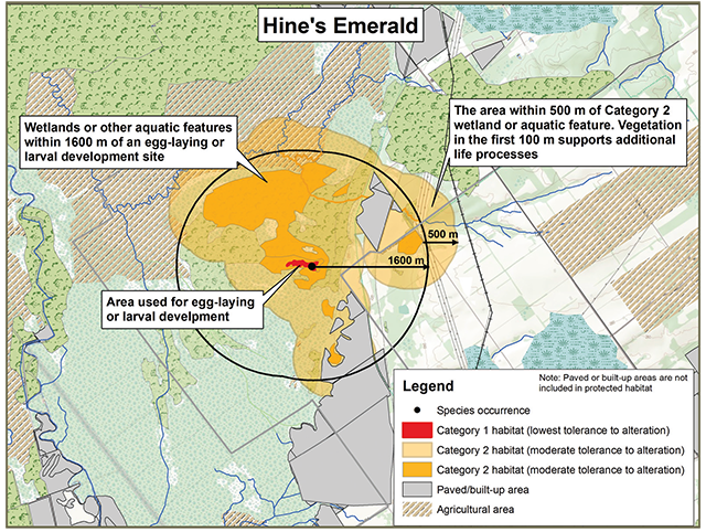
Brief description of the habitat regulation
The habitat regulation for Hine’s Emerald protects the part of a fen, marsh, spring or seepage area, or other aquatic feature that is being used for egg-laying or larval development. Suitable wetland and aquatic areas are protected within 1600 metres of an egg-laying or larval development site, plus an additional 500 metre area around these wetland or aquatic features. Areas that do not allow water to filter into the soil, such as paved areas and buildings, are not included in the 500 metre area.
Habitat categorization
The following text indicates how the species’ habitat would be categorized, as per the policy Categorizing and Protecting Habitat under the Endangered Species Act.
Category 1 (Red)
- The part of a wetland or aquatic feature used for breeding (e.g., egg-laying or larval development)
Category 2 (Orange)
- The part of a wetland or aquatic feature (including streams, ponds, or temporary pools) that is within 1600 metres of a breeding site (Category 1 habitat)
- Permeable areas within 500 metres of those wetland or aquatic features listed above. These areas contribute to the maintenance of groundwater flow into the wetlands or aquatic areas.
- Vegetation such as forests, shrub thickets, old fields, tree plantations, or hedgerows within 100 metres of a protected wetland or aquatic feature that is suitable for foraging, mating, and refuge
Sample application of the habitat regulation
Enlarge Figure 1: Sample application of the habitat regulation (PDF)
This content is summary only. For accurate reference of the regulation, please view Ontario Regulation 242/08 on e-laws.
This protection applies to areas that are used or were used by the species anytime in the past.
The regulation applies where the species is found in the City of Barrie, and the lower-tier municipalities of Adjala-Tosorontio, Clearview, Essa, Innisfil, Springwater, and Wasaga Beach within Simcoe County.
Supporting rationale
- Hine’s Emeralds rely on slow-moving, calcareous water with emergent vegetation for egg-laying and larval development. These conditions are associated with fens, marshes or areas where groundwater rises to the surface.
- Larvae depend on crayfish burrows for refuge from drought and for over-wintering. Crayfish burrows can be found along riparian edges.
- Adult Hine’s Emeralds travel to areas of natural vegetation for foraging, mating, and refuge. Because of the difficulty of flying through thickets and forests, Hine’s Emeralds typically stay near the edge of these types of habitats, which is approximately the first 100 metres.
- 1600 metres represents the average distance Hine’s Emerald will travel to carry out life processes.
- Alteration to the quantity and quality of groundwater moving into the wetlands used by the species is the greatest threat to its survival. Protecting the area within 500 metres of these wetlands will help to reduce these threats and is essential to maintaining breeding habitat for Hine’s Emerald.
Activities in Hine’s Emerald habitat
Activities in regulated habitat can continue as long as the function of these areas for the species is maintained and individuals of the species are not killed, harmed, or harassed. Activities are evaluated on a case-by-case basis for compatibility with regulated habitat.
Generally compatible:
- Removal of an individual shrub or tree for maintenance purposes
- Yard work such as the maintenance of existing lawns and gardens
- Renovations of small structures, such as a shed or a deck
- Regular use of well water for household and farm purposes
- Non-motorized vehicle use of existing recreational trails
Generally not compatiblefootnote *
- Alteration of aquatic or wetland habitat, such as altering water quality, flows, levels, vegetation characteristics, or increasing sediment deposition
- Large-scale construction, such as housing development or roads
- Significant reduction or clearing of forests and other vegetation (other than agricultural crops) within 100 metres of wetland or aquatic areas
- Broad-scale application of road salt, fertilizers, or pesticides, including drift or run-off into protected habitat
Landowners with species at risk habitat on their property may be eligible for funding programs that support stewardship activities to help protect and recover species at risk, such as the Species at Risk Stewardship Fund or the Species at Risk Farm Incentive Program. Visit Species at risk or contact your local MNRF office for more information.
Key terms
- Fen: A fen is a type of wetland that accumulates peat. They are located in areas where mineralized groundwater comes to the surface. Water pH is slightly acidic to neutral. Typical fen vegetation includes sedges and mosses, grasses, reeds, low shrubs, and sometimes a sparse layer of tamarack and white cedar. Fen communities are defined according to the Ecological Land Classification (ELC) for Southern Ontario: First Approximation and its Application dated September, 1998 and published by the Ontario Ministry of Natural Resources.
- Groundwater: Water that collects underground through percolation from the surface. It can be found in the spaces between soil and rock, and in underground formations of permeable rock, such as an aquifer. Groundwater interacts with surface water by feeding into lakes, streams, wetlands, or seeps and is a significant source of drinking water.
- Seepage area: An area where groundwater emerges at the surface, such as a spring.
- Vernal pool: A temporary pool of water which collects in a landform depression following snowmelt and heavy spring rains.
Footnotes
- footnote[*] Back to paragraph If you are considering an activity that may not be compatible with regulated habitat, please contact your local MNRF office for more information. Please note that any activity that occurs outside of regulated habitat but that has a reasonable potential to negatively impact regulated habitat could require authorization under the ESA.