Habitat Protection Summary for Wavy-rayed Lampmussel
This document outlines a brief description of the area that is protected as habitat for Wavy-rayed Lampmussel through a habitat regulation under the Endangered Species Act.
Species Conservation Act now in force
The Endangered Species Act, 2007 (ESA) and its regulations have been repealed. The Species Conservation Act, 2025 (SCA) and its regulations are now in force. Find more information on the Environmental Registry of Ontario (notice 025-0380 , notice 025-0909) and e‑Laws.
This information provides general guidance only. If you are planning an activity that may affect a species on the Protected Species in Ontario List, review the SCA and its regulations. You should also seek appropriate advice, such as legal or scientific advice, or contact SAROntario@ontario.ca.
If there is any inconsistency between this webpage and the SCA or its regulations, the legislation prevails.
The Wavy-rayed Lampmussel is a small freshwater mussel recognized by its yellow or yellowish-green rounded shell that has numerous thin wavy green lines. It is typically found in gravel or sandy bottomed areas of small to medium sized rivers where it requires a host fish to complete its lifecycle. The species is also found in Lake St. Clair however the invasion of Zebra Mussels has led to declines in this population. The Wavy-rayed Lampmussel was assessed by the Committee on the Status of Species at Risk in Ontario (COSSARO) and listed as threatened on September 28, 2010. More information about the species’ status and where it occurs in Ontario can be found on the Wavy-rayed lampmussel page.
Brief description of the habitat regulation
The habitat regulation for Wavy-rayed Lampmussel protects the watercourse segment up to the high water mark of a stream order greater than two in which Wavy-rayed Lampmussel has been found. This includes but is not limited to areas within the Grand, Thames, Maitland, Sydenham and Ausable River watersheds. Areas with natural and semi-natural vegetation, such as forest, woodland, thicket, wetland, old field, pasture, or meadow, within 30 metres of the occupied watercourse segment are also protected. Lawns and areas of agricultural cropland are not included.
In Lake St. Clair and the St. Clair River, the habitat regulation protects the area of the lake or river up to the high water mark within 5 kilometres of where a Wavy-rayed Lampmussel has been found. Unoccupied tributaries of Lake St. Clair and the St. Clair River are not included. In Lake St. Clair this protection is limited to areas where the water depth is 2 metres or less.
The regulation does not apply to areas of the Sydenham River downstream of the bridge on County Road 21 in the town of Dresden.
Habitat categorization
The following text indicates how the species’ habitat would be categorized, as per the policy Categorizing and Protecting Habitat under the Endangered Species Act.
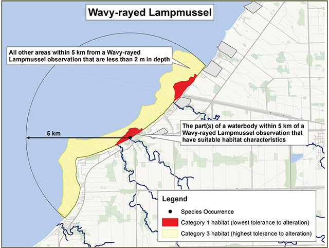
Category 1 (Red)
- the part(s) of Lake St.Clair, the St. Clair River, or watercourse segments with a stream order greater than two that are within 5 kilometres of where a Wavy-rayed Lampmussel has been found and that meet the following habitat characteristics:
- riffle/run habitat (in riverine systems),
- water depth of 2 metres or less (Lake St. Clair only),
- having substrates consisting of a mixture of fine particles, gravel and rocks, and
- provides access to suitable host fish
Category 2 (Orange)
- the part(s) of an occupied watercourse segment that meet the habitat characteristics described above but are further than 5 kilometres from a Wavy-rayed Lampmussel
- all other areas within the watercourse segment that are within 5 kilometres of the species
Category 3 (Yellow)
- all other areas in Lake St.Clair and the St. Clair River that are within 5 kilometres of a Wavy-rayed Lampmussel. For Lake St. Clair, this is limited to the areas less than 2 metres in depth
- all other areas within the watercourse segment further than 5 kilometres from a Wavy-rayed Lampmussel
- areas of natural or semi-natural vegetation within 30 metres of the occupied watercourse segment
Figure 1: Sample application of the habitat regulation for Wavy-rayed Lampmussel in watercourses
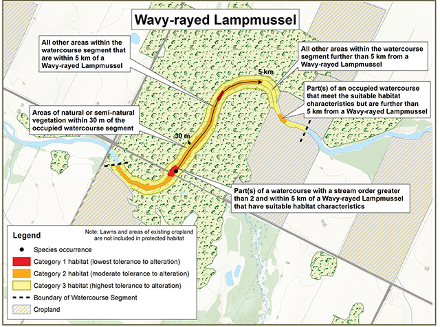
Figure 2: Sample application of the habitat regulation for Wavy-rayed Lampmussel in lakes
This content is summary only. For accurate reference of the regulation, please view Ontario Regulation 242/08 on e-laws.
This protection applies to areas that are used or were used by the species anytime in the past.
The regulation applies where the species has been found in the Municipality of Chatham-Kent, the Regional Municipality of Waterloo, the counties of Brant, Wellington, Perth, Huron, Lambton, Middlesex and Oxford, and Lake St. Clair and the St. Clair River.
Supporting rationale
- Wavy-rayed Lampmussel has been found in small to medium streams.
- the main factor limiting the species’ occurrence is likely the availability of silt-free, riffle/run habitat.
- if a population has been found in one part of a watercourse segment, it is likely to be found in suitable habitat in other areas of the same segment.
- inclusion of habitat upstream and downstream of known Wavy-rayed Lampmussel locations allows for dispersal of the species through host fish movement.
- declining water quality is one of the primary threats to riverine populations of Wavy-rayed Lampmussel. Protecting vegetated areas within 30 metres of the high water mark will reduce contamination of the aquatic habitat.
Activities in Wavy-rayed Lampmussel habitat
Activities in regulated habitat can continue as long as the function of these areas for the species is maintained and individuals of the species are not killed, harmed, or harassed. Activities are evaluated on a case-by-case basis for compatibility with regulated habitat.
Generally compatible
- recreational use of the water such as swimming and boating
- recreational fishing
- continuing to farm croplands already in production
Generally not compatiblefootnote *
- significant alteration of aquatic habitat (e.g. vegetation, streambed), water temperature and water chemistry
- dredging, installation of bridges, culverts or pipeline crossings or the construction of dams
- land-based activities that significantly affect water quality (e.g. through input of nutrients, sediment or toxic substances)
Landowners with species at risk habitat on their property may be eligible for funding programs that support stewardship activities to help protect and recover species at risk, such as the Species at Risk Stewardship Fund or the Species at Risk Farm Incentive Program. Visit Ontario.ca/speciesatrisk or contact your local MNRF office for more information.
Key terms
- Watercourse segment:
- A distinct section of a river or stream characterized by relatively similar hydrography and surficial geology and which is not separated by in-stream barriers that prevent fish movement. The “Protocol for Applications Used in the Aquatic Landscape Inventory Software Application for Delineating, Characterizing and Classifying Valley Segments within the Great Lakes Basin” (Stanfield and Kuyvenhoven, 2002) describes in more detail how the boundaries of segments are delineated. This protocol and files which show the mapped watercourse segments are available through Land Information Ontario.
- Stream order:
- means the order of a stream as defined by Strahler, where the smallest unbranched channels are considered as 1st order, whereby the joining of two such channels forms a 2nd order, and subsequent unions of similar stream orders results in successively higher stream order.
Footnotes
- footnote[*] Back to paragraph If you are considering an activity that may not be compatible with regulated habitat, please contact your local MNRF office for more information. Please note that any activity that occurs outside of regulated habitat but that has a reasonable potential to negatively impact regulated habitat could require authorization under the ESA.