Minister’s Five Year Report on Lake Simcoe: To protect and restore the ecological health of the Lake Simcoe watershed
The Minister’s Five-Year Report on Lake Simcoe outlines actions taken to address the goals of the Lake Simcoe Protection Plan and summarizes the results of ongoing environmental monitoring in the watershed.
Minister’s message
I am pleased to share the first Five-Year Report on Lake Simcoe. This report highlights some of the work that Ontario and its partners are undertaking to protect and restore this cherished natural asset.
There is good news to report. Our data tells us that the health of the lake is improving. More oxygen is available in the deep cold parts of the lake compared to 30 years ago, and we have seen encouraging signs of recovery in coldwater fish species. We are also seeing indications that overall total phosphorus has decreased significantly in most of the watershed’s tributaries.
However, there’s more work to be done. Further effort is needed to protect and restore the health of the Lake Simcoe watershed. Continued monitoring and research are important in assessing the watershed’s health and understanding interactions between stressors and indications of health.
We will continue to work on reducing Lake Simcoe’s phosphorus levels, restoring a self-sustaining coldwater fishery, responding to adverse effects related to climate change and invasive species, protecting the ecological health of the watershed, improving water quality, and promoting environmentally sustainable practices around the lake. We will also apply the lessons learned here to our work in the Great Lakes and other watersheds in the province.
It has taken a long time for the Lake Simcoe watershed to get to its present state, and it will take time to see substantial improvement. Our management approach is adaptive, incorporating results of research and monitoring to improve our methods as we go.
We are working with many partners to protect the lake and its watershed. I look forward to building on the spirit of collaboration that defines the effort to protect the Lake Simcoe watershed. Our collective action to improve its health will ensure that the lake continues to be drinkable, swimmable and fishable, and remain a resource our children and grandchildren will be able to enjoy.
As part of our commitments made in the Lake Simcoe Protection Act, 2008, this report provides key results of our monitoring efforts and the progress we, and our partner agencies, are making toward the objectives of the Lake Simcoe Protection Plan.
The Honourable Glen Murray
Minister of the Environment and Climate Change
Government of Ontario
Background
As the largest lake in southern Ontario outside of the Great Lakes, the Lake Simcoe watershed contains significant natural, urban and agricultural systems including parts of the Oak Ridges Moraine and the Greenbelt. It also holds provincially significant wetlands, woodlands, and prime agricultural areas, including specialty crop areas such as the Holland Marsh.
Six water treatment plants draw water from the lake providing purified, clean drinking water for several communities. The Lake Simcoe watershed is home to many species, including over 75 fish species, with over 50 in the lake alone, and at least 30 species at risk. The watershed is home to 18 distinct subwatersheds.
The lake and watershed also provide diverse recreational opportunities, from ice-fishing and snowmobiling in the winter to boating, fishing and hiking in the summer. The lake and tributaries are also receiving water bodies for 14 municipal (and one industrial) water pollution control plants (WPCPs).
Human activity has significantly affected the ecological health of the watershed. Development in the area has changed the natural landscape; excessive nutrients and other contaminants have degraded water quality, threatening native aquatic life in the lake, such as coldwater fish. Other issues include shoreline hardening and erosion, loss and fragmentation of natural areas, invasive species and climate change.
Coordinated action to restore the lake began in the early 1990s with the Lake Simcoe Environmental Management Strategy.
The Ontario government developed Canada’s first lake-specific legislation in 2008: the Lake Simcoe Protection Act. This act enabled the creation of the Lake Simcoe Protection Plan (the Plan) in 2009 that takes into account the lake’s 722 square-kilometres of water surface and the 2,899 square-kilometre watershed that drains into Lake Simcoe. In 2010, we released the Lake Simcoe Phosphorus Reduction Strategy to guide the implementation of phosphorus reduction efforts across multiple partners.
The Plan focuses on six key themes that will improve the health of the watershed and the lake – aquatic life, water quality, water quantity, shorelines and natural heritage, other threats and activities (e.g., invasive species, climate change and recreational activities) and implementation. Each chapter contains targets, indicators and policies.
A Science Committee was created in 2010 to review progress on environmental indicators and provide advice on an ongoing basis. As a result, scientific evidence and advice that reflects a broad range of expertise plays an important role in decisions about the lake and watershed. A multi-stakeholder Coordinating Committee representing a variety of interests in the watershed was also established to provide advice to guide the implementation of the Plan. These two committees work closely together to provide advice to the Minister on the path forward for Plan implementation.
The province and partners have deployed a variety of innovative and adaptive tools to implement the Plan. Our work in Lake Simcoe is an example for coordinating other watershed improvement efforts across the province.
Progress to date
The province and our partners are committed to monitoring ecosystem indicators defined in the Plan, and to reporting on them every five years. In 2014, the ministry worked with the Ministry of Natural Resources and Forestry (MNRF) and the Lake Simcoe Region Conservation Authority (LSRCA) to analyze all available data collected on Lake Simcoe monitoring programs. The resulting Monitoring Report1 includes data trends from as early as the 1960s up to 2012 on the indicators identified in the Plan.
This Minister’s Five Year Report on Lake Simcoe translates the detailed scientific and technical data in the Monitoring Report into information that is relevant and accessible to all of our partners and the general public. It summarizes the advice provided to the ministry by the Minister’s Advisory Committees (see appendix), provides evidence of the collective action being taken to implement the Plan, and highlights how everyone can get involved. It describes the results of monitoring programs and the extent to which the objectives of the Plan are being achieved. In this way, this Minister’s Five Year Report on Lake Simcoe addresses requirements under both section 12.1 and 12.2 of the Lake Simcoe Protection Act. The report also provides an update on the implementation and progress of the Phosphorus Reduction Strategy, as required under the amended Policy 4.24 of the Plan.
We are seeing encouraging signs of improvement in the long-term health of the lake:
- The concentration of total phosphorus has decreased significantly in most of the watershed rivers and streams
- Levels of deepwater dissolved oxygen at the end of summer have significantly improved, and
- As a result, sensitive aquatic life such as lake trout, lake whitefish and cisco (lake herring) have shown signs of recovery.
However, there are a number of stressors affecting the health of Lake Simcoe and its watershed:
- The watershed is currently home to more than 435,000 people based on a 2011 census, an increase of approximately of 135 per cent since 1981.
- The amount of natural and woodland cover mapped in 2008/09 was below the levels recommended for wildlife habitat. More than half of the lake’s shoreline has been altered from a natural state.
- The aquatic life of Lake Simcoe continues to be affected by poor water quality, climate change and invasive species.
Further effort is needed to protect and restore the health of the Lake Simcoe watershed. Continued monitoring and research are important in assessing the watershed’s health and understanding interactions between stressors and recovering trends in indicators.
It has taken a long time for the Lake Simcoe watershed to get to its present state, and it will take time to see substantial improvement. The management approach is adaptive, incorporating results of research and monitoring to improve our methods as we go.
1 Young, J. and H. Jarjanazi, 2015. Lake Simcoe Monitoring Report, 2014. Ministry of Environment and Climate Change, Environmental Monitoring and Reporting Branch. PIBS 9823e.
Priorities
The first five years of the Plan’s implementation focused on the issues identified as the most critical to the health of Lake Simcoe:
- Restoring the health of aquatic life within the Lake Simcoe watershed
- Improving water quality, including reducing loadings of phosphorus to the lake
- Maintaining sufficient water quantity
- Improving the health of the ecosystem by protecting and rehabilitating important areas such as shorelines and natural heritage areas, and
- Addressing impacts of invasive species, climate change, and recreational activities.
A subwatershed approach has helped to determine priorities in different areas of the watershed, depending on environmental conditions and specific management considerations. This approach has been critical to prioritizing initial actions and moving forward with an action plan.
Restoring Aquatic Life
Aquatic life in the tributaries and the lake is an important indicator of ecosystem health. Key native lake species such as lake trout, lake whitefish and cisco depend on cold, well-oxygenated water to swim, feed and grow (see Figure 1). Habitat degradation and low dissolved oxygen are a primary cause of failure for many coldwater species in Lake Simcoe.
Plan Objective: restore a self-sustaining coldwater fish community in Lake Simcoe.
Restoring the coldwater fish community depends on improved water quality and the protection of habitat as well as sound, strategic fisheries management. Indicators of progress include:
- Natural reproduction and survival of native aquatic communities
- Presence and abundance of key sensitive species (e.g., lake trout and brook trout), and
- Shifts in cold, warm and tributary fish community composition.
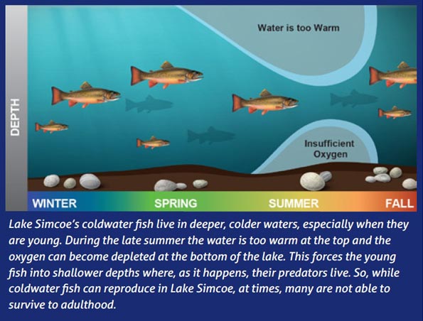
Figure 1: Relationship between dissolved oxygen and health of aquatic life.
Actions to Improve Aquatic Life
To protect and restore coldwater fish and other aquatic life we need to improve the deep, coldwater habitat of the lake. Excess phosphorus loading to the lake is identified as a significant stressor and has led to the depletion of dissolved oxygen in deep waters of the lake that provide essential habitat for coldwater species. This report provides detail on the actions taken to date to reduce phosphorus loading in order to work towards reaching the target of 7 milligrams per litre of dissolved oxygen.
In addition to the actions taken to reduce phosphorus loading to the lake and rivers, MNRF is leading additional actions to improve the health of Lake Simcoe’s fish communities and aquatic life. MNRF is working with local partners to implement the policies under the Plan related to:
- Supporting the recovery of species such as walleye and muskie by re-establishing lost habitat through wetland enhancement and spawning area creation.
- Understanding the current socio-economic value and significance of the Lake Simcoe fishery and aquatic community to help inform management decisions in the watershed
- Enhancing long-term aquatic community monitoring programs – MNRF has monitored Lake Simcoe since the 1950s. Monitoring work by MNRF’s Lake Simcoe Fisheries Assessment Unit includes surveys of winter and open-water anglers, monitoring of fish diet and growth, monitoring nearshore and offshore fish communities, biodiversity, and invasive species.
- Employing innovative research techniques and new technology to understand and assess the health of the aquatic communities of Lake Simcoe. MNRF has conducted baseline mapping of all known aquatic habitats, and has used hydroacoustics to learn how invasive species and climate change have impacted the offshore aquatic community.
Evidence of Recovery
We are seeing several signs of recovery in the aquatic life of Lake Simcoe. Figure 2 shows evidence of recovery in the sensitive, native coldwater fish community from MNRF’s offshore monitoring program that began in 2003.
After almost 20 years, evidence of natural lake trout reproduction was observed in 2001, and wild lake trout have been consistently collected each year since 2003. The wild lake whitefish catch has also increased in abundance in recent years. This means that more lake trout and lake whitefish are reproducing naturally, and more are surviving into adulthood. This is also evidenced by the proportion of naturally-reproduced lake trout and lake whitefish caught by anglers, which rose from less than 20 per cent in the mid-2000s to more than 50 per cent in the winter of 2014. In addition, both monitoring and hydroacoustic research have confirmed that cisco abundance has increased significantly, with excellent year classes in 2004, 2008 and 2012.
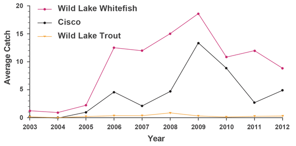
Figure 2: Native Lake Simcoe coldwater fish catch
In addition to fish communities, benthic invertebrate communities in the lake are showing signs of recovery. Benthic invertebrates are small organisms without backbones that live on, under, or around the rocks and sediment at the bottom of waterbodies. Benthic invertebrates are an important component of watershed biodiversity. Several species of benthic invertebrates that are sensitive to low oxygen conditions have reappeared in recent years, including three sensitive insects in the chironomid genera family (non-biting midges), as well as the opossum shrimp.
In Lake Simcoe’s rivers, there is still work to do to improve ecological health. Since 2002 the LSRCA has assessed fish and benthic invertebrate communities at more than 200 tributary sites across the watershed. Less than one-quarter of the sites were identified as having “good” ecological health based on the fish species present and just over one-third based on the benthic invertebrate communities.
Using Evidence to Manage Fisheries
MNRF is working together with scientists, the federal government, local municipalities, the LSRCA, research organizations and key stakeholders to use this evidence to inform fisheries management decisions.
They established a Lake Simcoe Fisheries Stakeholder Committee and participated in the development and implementation of the Lake Simcoe Fish Community Objectives (FCOs). This is the first set of FCOs outside of the Great Lakes and they have influenced key management decisions about the Lake Simcoe fishery as indicated by a few recent examples:
- After the coldwater fish community experienced a collapse starting in the 1960s for some species, regulations and special management actions were put in place to protect species such as lake trout, lake whitefish and cisco. With low levels of natural reproduction, lake trout and lake whitefish populations have since been maintained by a stocking program. In the hope of encouraging natural reproduction, the fishery management decided to close the cisco fishery in 2001.
- Based on the signs of recovery in natural populations (see Figure 2), MNRF reviewed the coldwater fish stocking program and established new stocking targets, guided by the Fish Community Objectives. In 2010, the ministry reduced the stocking of lake trout clipped yearlings by one-half (from 100,000 to 50,000) to further support natural reproduction of the species.
- Following observed improvements in cisco abundance, (see Figure 2), MNRF reintroduced an open season for cisco in January 2015, for the first time in 14 years.
Improving Water Quality
Degraded water quality has placed significant stress on Lake Simcoe. Increased urban, rural, recreational and agricultural activities have resulted in increased pollutants.
The Plan establishes several targets related to water quality:
- reduce phosphorus loadings to achieve a target for dissolved oxygen of 7 milligrams per litre in the lake (long-term goal currently estimated at 44 tonnes per year)
- reduce pathogen loading to eliminate beach closures, and
- reduce contaminants to levels that achieve Provincial Water Quality Objectives or better.
The Plan builds on protections for the watershed that are provided by provincial plans and legislation, including the Clean Water Act, 2006, the Conservation Authorities Act, the Ontario Water Resources Act, and the Planning Act. For example, the Clean Water Act requires local multi-stakeholder committees to identify activities that pose a risk to municipal drinking water sources, and develop plans to manage the risks.
The Source Protection Plan for the South Georgian Bay Lake Simcoe Source Protection Region has been approved and came into effect on July 1, 2015. Source protection is a shared responsibility between municipalities, conservation authorities, provincial ministries and others. For example, the legislation and plans introduce various tools to manage land uses and give municipalities the authority to address activities that pose a risk of contaminating sources of municipal drinking water on a site-specific basis. The province has invested nearly $28 million towards protecting drinking water sources in the region. While the Source Protection Plan focuses on risks to quality and quantity of sources of municipal drinking water, the Lake Simcoe Protection Plan enhances that protection by requiring protection and restoration of key ecosystem functions.
Efforts to Reduce Phosphorus
Excessive phosphorus is considered the most significant cause of water quality impairment in the Lake Simcoe watershed and its tributaries. Too much phosphorus leads to excessive aquatic plant and algal growth. When algae die and decay in the deeper areas of the lake, they create an oxygen shortage that affects coldwater fish such as lake trout and lake whitefish. These fish need oxygen to survive and reproduce.
Plan Objective: reduce loadings of phosphorus and other nutrients of concern to Lake Simcoe and its tributaries.
There are two reliable measures of phosphorus for the lake: phosphorus loads and phosphorus concentrations. The total amount of phosphorus carried into Lake Simcoe is the phosphorus load. In this report, it is expressed in metric tonnes (1 tonne = 1,000 kg), and is measured over a hydrological year (from June 1 to May 31). The phosphorus concentration is the amount of phosphorus in each litre of water.
In 2010, the province worked with partners to develop the Phosphorus Reduction Strategy, an aggressive plan to reduce phosphorus loading in the lake by almost 40 per cent — from 72 tonnes to 44 tonnes per year — by 2045. This target is the loading estimated to achieve the deepwater dissolved oxygen target of 7 milligrams per litre, the optimal concentration to support a sustainable coldwater fish community.
Since the launch of the Phosphorus Reduction Strategy, the ministry and our partners have delivered several key actions to reduce phosphorus load from all major sources:
- Sewage Treatment Plants (STPs) – There are 15 STPs in the watershed that process sewage before disposing of the treated effluent into the lake or rivers. Although all are operating at a level that meets or is better than provincial standards, the discharge still contains some phosphorus.
- Baseline phosphorus effluent concentrations (limits) and loading caps were established for each STP under the Phosphorus Reduction Strategy. In June 2012, the Environmental Compliance Approvals (ECA) for all of the lake’s STPs were amended by the ministry to include new limits and loads. This drove the need for some STPs to upgrade their treatment technology to meet the new ECA requirements. As of June 2015, all STPs in the watershed are in compliance with their ECAs, including their annual phosphorus limits. The ministry continues to work with municipalities to ensure compliance post-2015.
- This regulatory action led to improvements in phosphorus removal technology, and despite significant population growth, the STPs in the Lake Simcoe watershed are now some of the most effective at removing phosphorus in Ontario. The total phosphorus reduction from the 1980s to present is approximately 30 tonnes.
Table 1 – Phosphorus Loadings of Sewage Treatment Plants in the Lake Simcoe Watershed: 2010-2014
Sewage Treatment PlantPRS
Limit (kg/y)Annual Loads (kg/y)
2010Annual Loads (kg/y)
2011Annual Loads (kg/y)
2012Annual Loads (kg/y)
2013Annual Loads (kg/y)
2014Lake Simcoe (Beaverton) 190 33 19 25 41 50 Bradford 698 149 151 147 204 232 Sutton 187 49 69 53 42 53 Beaverton River 2 Lagoon (Cannington) 97 34 56 43 48 34 Innisfil (Alcona) 629 176 215 134 171 160 Orillia 996 600 504 501 471 510 Barrie 2774 1423 1346 1154 1524 876 Uxbridge Brook 286 89 86 87 100 96 Holland Landing Lagoon 124 62 32 40 47 29 Keswick 655 385 652 452 193 77 Mount Albert 75 7 9 14 15 20 Schomberg 75 11 11 9 11 16 Lagoon City 124 32 30 27 34 35 Beaverton River 1 Lagoon (Sunderland) 58 8 8 7 11 14 Silani Sweet Cheese 27 14 23 19 12 9 Total 6995 3073 3211 2711 2924 2211 - The Keswick STP is an example of how new technology can impact the operation of an STP. The recent upgrading of their facility (following the completion of an Environmental Assessment) has allowed the plant not only to accommodate future growth in the area, but advanced treatment has reduced their phosphorus discharge significantly as demonstrated in Table 1. The Phosphorus Reduction Strategy highlighted the importance of innovation and new technology in achieving the long term phosphorus targets and the Keswick STP is an example of how this can be achieved.
- Septic System Inspections and Decommissioning – A properly functioning and maintained septic system reduces or eliminates the release of pathogens into soil, groundwater, surface water and air and provides adequate treatment of sanitary sewage and effluent. Inspecting and decommissioning failing septic systems will go a long way to reduce phosphorus loading, while protecting Ontario’s drinking water and the natural environment.
- There are approximately 3,700 septic systems within 100 metres of the lake. Phosphorus loading from septic systems is estimated to contribute approximately 5 per cent of the phosphorus load to Lake Simcoe. Identifying malfunctioning septic systems that may be contributing to the contamination of Lake Simcoe will help protect the quality of our drinking water and environment. A new Building Code regulation is now in place to require municipalities, health units and conservation authorities to inspect septic systems every five years. All systems within 100 metres of lakes, ponds, and permanent rivers or streams in the Lake Simcoe watershed shall have a septic re-inspection completed before January 1, 2016 and every five years thereafter.
- Some municipalities have already made significant progress on re-inspection and decommissioning, for instance, the Township of Ramara completed inspections of 1,254 properties in 2014.
- Two ongoing stewardship and incentive programs offer funding for eligible septic system improvements. These are the LSRCA’s Landowner Environmental Assistance Program, and the federally-funded Lake Simcoe & South-eastern Georgian Bay Community Stewardship Program. From 2009 to 2012, the Community Stewardship Program co-funded the upgrading or replacing of more than 130 septic systems. Since 2009, the LSRCA has provided technical and financial support through the Landowner Environmental Assistance Program to upgrade, repair and replace 400 faulty or malfunctioning septic systems.
- The Ministry of Agriculture, Food and Rural Affairs (OMAFRA) has produced and distributed more than 3,500 copies of a SepticSmart DVD, educational booklets, and maintenance checklists across the province. The videos are available here.
- Atmospheric Deposition – Major sources of atmospheric phosphorus come from unpaved roads, construction sites, agriculture and aggregate operations, as well as natural sources like pollen, human sources like the burning of fossil fuels, and through wind transport of disturbed or exposed soil. In 2013, the ministry worked with partners to examine the issue of atmospheric deposition. The report identifies the most effective opportunities to reduce atmospheric deposition loads.
- OMAFRA has helped establish several demonstration sites and hosted workshops for farmers and practitioners on the use of windbreaks to reduce atmospheric deposition of phosphorus. Several videos are available here.
- MNRF encourages aggregate operations to adopt best management practices to minimize phosphorus contributions through atmospheric deposition. The Aggregate Resources Act includes standards requiring operators to minimize adverse impacts on the environment. Because of location, distance from lake and emission controls/best practices in place, the contribution of aggregate operations is minor.
- Some activities on construction sites can cause dust containing phosphorus to be deposited into the lake and rivers. If trees and plants are removed during the process of land development, natural drainage pathways are altered and soils are stripped away by wind and water erosion. Some municipalities have bylaws or municipal codes but practices in the watershed vary widely, suggesting significant room for greater uptake. The ministry is working with the LSRCA to support municipalities and developers with adopting erosion and sediment control policies and practices at locations within the Lake Simcoe watershed.
- Holland Marsh and Smaller Polders – Polders are former wetlands that are drained for agricultural use. There are five polders in the watershed, including the Holland Marsh. Water pumped from the polders can contain high levels of phosphorus from fertilizers or vegetable wash water. The province is working closely with all partners to find cost-effective ways to reduce phosphorus loading from the polders:
- OMAFRA partnered with the Universities of Waterloo and Windsor, the LSRCA and the Holland Marsh Growers’ Association to test and demonstrate small-scale wastewater treatment systems for farm field runoff and vegetable processing in the Lake Simcoe watershed.
- The ministry and OMAFRA are working with the Holland Marsh Growers’ Association and the farmers and vegetable washing operators to ensure that the water used to wash and process vegetables is treated and discharged according to the requirements under the Ontario Water Resources Act.
- The LSRCA is also looking at the feasibility of treating pump-off water from the Holland Marsh to reduce annual phosphorus loading and potential opportunities for phosphorus recovery pilot projects in the marsh.
- Watershed Streams and Tributaries – When water from rain or melted snow flows over land, it picks up dirt, dust, oil, salt, fertilizers, manure, animal waste and detergents that wash into creeks and rivers and into the lake. The tributaries deliver the largest portion of the phosphorus load to Lake Simcoe with an average of 67 per cent of the load to the lake.
a. Actions to reduce loading to Tributaries from Agricultural/Rural Sources:
OMAFRA has worked extensively to reduce phosphorus and improve sustainable agriculture practices in the watershed through a variety of projects. OMAFRA has collaborated with local universities, conservation authorities, research institutes and agricultural associations to:
- Share information on nutrient management through demonstration sites
- Research the most effective and efficient phosphorus application rates
- Understand the quality of field runoff water under different cropping practices
- Collect and reduce the agricultural waste being burned or buried on farms
- Understand the influence of land ownership on farmers’ decisions to adopt recommended practices
- Develop best practices with sod farmers to reduce soil loss and nutrient loading
- Encourage the use of windbreaks in the croplands west of Lake Simcoe, where windborne soil erosion may be impacting water quality in the lake
- Develop soil phosphorus testing methods specifically for muck soils in areas such as the Holland Marsh
- Produce seven videos and a documentary on successful stewardship projects in the Holland Marsh.
- Understand how farmers are motivated by different types of incentives to adopt best management practices that reduce fertilizer and manure runoff
- Provide guidance on water treatment technology for the greenhouse vegetable, greenhouse floriculture and container nursery sectors, and
- Reduce phosphorus loading and improve riparian health in the Talbot River subwatershed.
The Lake Simcoe Farm Stewardship Program provided environmental cost-share funding for farmers in the Lake Simcoe watershed to implement best management practices. The program operated from 2008 through 2012, funded in part by both the federal and provincial governments. During this time, 440 on-farm projects were completed in the watershed to implement best practices that reduce phosphorus runoff and improve water quality in nearby rivers and streams, and improve wildlife habitat.
b. Actions to reduce loading to Tributaries from Urban Sources
The rivers in the Lake Simcoe watershed with the highest phosphorus concentrations are those that drain from urban and agricultural lands, including the East Holland River downstream of Newmarket and Aurora. When land is developed, the natural water cycle is changed. More hard surfaces (pavement) increase runoff and prevent rain and snow from infiltrating into the ground.
Growth approved under the Places to Grow Act will continue into 2031. Urban land cover in the watershed is projected to add approximately 12,235 hectares of new growth by 2031. Urban stormwater run-off is a major contributor of pollutants entering Lake Simcoe.
Plan Objective: promote environmentally sustainable land and water uses, activities and development practices.
The LSRCA and the ministry are working together with local municipalities and partners to explore innovative approaches for new development and ways to manage stormwater runoff.
Through a market transformation program called ‘RainScaping’, LSRCA is moving in a new direction to manage stormwater. This program is designed to build more sustainable communities by incorporating low impact development (LID) practices into new development projects.
The core principle is modeled after nature and mimics the natural flow of water as it infiltrates into the soil. This minimizes the impact of urban development by reducing the volume of stormwater runoff as well as potential pollutants the runoff may carry.
Approaches include taking advantage of natural landscape features, minimizing impervious surfaces like pavement, and treating stormwater as a resource rather than a waste product.
In 2015, the LSRCA updated its stormwater management guidelines to require low impact development as a first line of defense in stormwater management, and is working to support implementation:
- To encourage new developments to incorporate LID features into their design, LSRCA is:
- Working with developers to incorporate LID technology into site design
- Providing training on LID for developers and approval agencies
- Workshops with over 200 municipal staff on LID as a stormwater tool, and identifying opportunities to implement in each municipality.
- LSRCA’s efforts have been recognized by all watershed municipalities, and many are adapting their local approaches and policies. Through federal funding, LSRCA is supporting completion of eight municipal LID demonstration projects. Barrie, Newmarket and Aurora have, or are in the process of creating LID demonstration sites or rainscaping gardens to help residents and landowners understand the benefits of LID.
- There are more than 200 traditional stormwater ponds in the watershed. These ponds capture and slowly release the water that can’t easily infiltrate into the ground because of the paved surfaces in urban environments. An assessment of stormwater ponds in 2010 revealed that many of the ponds are not operating at their intended efficiency. The LSRCA is providing technical support to municipalities to determine the effectiveness of existing stormwater management assets in settlement areas around the watershed.
- Regional and local governments, together with the LSRCA, have identified opportunities to upgrade municipal stormwater facilities to improve overall treatment and phosphorus removal at the source. Several retrofits have been completed in Newmarket, the Town of East Gwillimbury and the Town of Uxbridge since 2010. They continue to be monitored and their improvements to water quality evaluated.
- The Plan requires that watershed municipalities prepare Stormwater Master Plans for each settlement area in the watershed. In April 2011, the LSRCA released “Comprehensive Stormwater Management Master Plan Guidelines” to support municipalities in their assessment of the facilities and the development of master plans. At the time of this report, all watershed municipalities had initiated the development of their master plans, and several had initiated their implementation. The ministry and LSRCA are working to provide guidance and support to municipalities throughout the master planning process.
- The ministry has also supported research on the measures to reduce phosphorus by controlling sediment and erosion from construction sites. A recent project with Ryerson University reviewed best practices in implementing erosion and sediment control programs, evaluated the effectiveness of the practices, and identified preferred measures for our watershed. On this front, the LSRCA has offered Certified Inspector of Sediment and Erosion Control training to over 140 participants.
Recognizing Innovators:
LSRCA has collaborated with York Region, the Toronto Region Conservation Authority and Mosaik Homes to incorporate LID solutions in Newmarket. Runoff from the roofs, roads and driveways will be infiltrated close to source through rain gardens, bioswales and wetland features. Incorporating the LID features has eliminated the need for a stormwater pond. This enables water to be stored during high flow periods to be released slowly into wetland area.
The ministry commissioned a study in 2010 to assess the feasibility of water quality trading to help reduce nutrient loads, while also balancing potentially competing objectives of growth and improved environmental quality. The study concluded that trading could be a viable option for the watershed, however the ministry decided that further evaluation and discussions were needed, in consultation with watershed stakeholders.
In 2013, the LSRCA received funding through the province’s Showcasing Water Innovations program and support from watershed stakeholders to research and design a potential water quality trading program to address excess phosphorus The LSRCA has developed a proposed approach to pilot and is seeking feedback and future support for the initiative (for more information, visit the Lake Simcoe Region Conservative Authority).
The intent of the LSRCA program would be to address nutrient contributions from urban sources and help finance phosphorus reduction activity across a broad range of opportunities.
Phosphorus Reduction Strategy Review
The 2010 Phosphorus Reduction Strategy was developed to support the phased reduction of phosphorus. The strategy relies on adaptive management, which means it should be amended and updated as necessary to reflect ongoing research and technological advancements. As part of this Minister’s Five Year Report, the ministry is required to review and report on the implementation and progress of the Phosphorus Reduction Strategy.
Actions and strategic directions under the Phosphorus Reduction Strategy were reviewed in 2015, with input from key partners. Recognizing that the province and our partners remain in the early stages of implementation, significant changes to the content or direction of the strategy are premature at this time. That said, several key recommendations have been identified to support the continued implementation of the Phosphorus Reduction Strategy:
- Improve the tracking of actions taken by various partners to reduce phosphorus loads to watershed streams and tributaries from agricultural and urban areas
- Ensure effective tools are in place to manage the impacts of growth on the lake (e.g. low impact development)
- Promote the optimization of new and existing stormwater management facilities
- Discuss opportunities with all stakeholders on the potential of implementation of water quality trading
- Continue to promote and support site-level stewardship and best management practices
- Support the development of innovative new technology for the treatment of wastewater, stormwater and agricultural runoff, and
- Promote the development and implementation of strategies to mitigate the effects of extreme weather events and associated phosphorus loading.
Encouraging Trends
The ministry partners with the LSRCA to monitor the lake and streams to assess trends in the health of our watersheds. With the launch of the Plan, monitoring stations were added to sample more sites, more often and under a variety of conditions in the lake and across the watershed. Ministry labs analyze more than 30,000 lab samples per year from the across the watershed. This information is shared widely – the ministry has responded to almost 200 requests to compile data for individual research projects since 2008.
Our monitoring data show encouraging long-term trends in both phosphorus loads and phosphorus concentrations, despite annual variations. You can read more about phosphorus loads in the Lake Simcoe Phosphorus Loading Reports released every three years in collaboration with the LSRCA.
The graph below (Figure 3) shows that the average annual phosphorus load to Lake Simcoe is lower now than it was during the early 1990s when it was often more than 100 tonnes per year. The largest phosphorus loads came from the tributaries, which are dependent on both the volume of water in the tributary and the phosphorus concentration. Therefore loads are largely affected by yearly fluctuations in weather, with more precipitation causing greater flows and higher phosphorus loads. This was clear in 2008 when both tributary flow (see grey line in chart) and nutrient load in the tributaries were much greater than normal.
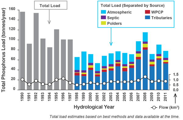
Figure 3: Annual phosphorus loads and total flows to Lake Simcoe (1990 to 2011)
Spring phosphorus concentration, measured in April and May once the ice is off the lake is also improving. The graph below shows a significant decrease in spring phosphorus concentration despite annual variations (see Figure 4).
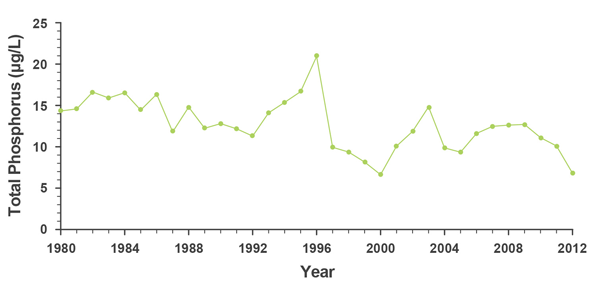
Figure 4: Lake spring phosphorus concentration (1980-2012)
These phosphorus reductions are helping to improve conditions for aquatic life. Figure 5 shows that, while levels can vary from year to year, dissolved oxygen levels are slowly increasing. There is more oxygen available now in the deep cold parts of the lake than there was 30 years ago and this supports the recovery that has been observed of coldwater fish species and other aquatic life.
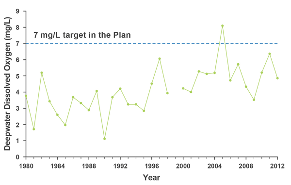
Figure 5: The end-of-summer volume-weighted deepwater dissolved oxygen concentration in Kempenfelt Bay (1980-2012)
These trends in decreasing phosphorus and increasing dissolved oxygen are particularly encouraging, given that they have occurred during a time of significant population growth and increasing urbanization in the watershed. Continuing to track trends over time will help to guide the ministry and our partners as we work to further reduce the sources of phosphorus to the lake.
Although increased deepwater dissolved oxygen in the lake is improving the habitat for sensitive aquatic life, the deepwater dissolved oxygen at the end of summer is not consistently at the Plan target of 7 milligrams per litre. There is still much work to do to raise the oxygen levels to an optimal level for a self-sustaining coldwater fish community. Monitoring programs and research must continue to support decisions that will help reduce phosphorus loading and improve dissolved oxygen concentrations.
Actions to Address Other Emerging Water Quality Threats
In addition to phosphorus, several other contaminants make their way into the lakes, including heavy metals, organic chemicals, chloride, pathogens and pharmaceuticals. Not all of these are measured annually in Lake Simcoe, but research is underway to identify emerging trends.
Plan Objective: reduce the discharge of pollutants to Lake Simcoe and its tributaries.
The Plan prescribes activities to identify and address the causes of water quality impairment and enhance existing water quality. Actions taken to reduce phosphorus also contribute to the reduction of other contaminants and water quality threats including:
- Heavy metals, organic chemicals and total suspended solid
- Heavy metals and organic chemicals settle into the lake sediments, which are monitored through sediment surveys every 5-10 years. A 2008 survey showed that metal concentrations of historical concern (e.g., chromium) have decreased from peak levels due to improved wastewater treatment and changes in industrial activity, while metals typically found in uncontrolled urban stormwater run-off (e.g., zinc) remain at elevated concentrations.
- Total suspended solids can cloud water, decreasing water clarity and impairing spawning habitat for some fish species. The LSRCA and the ministry are currently monitoring total suspended solids regularly in tributaries.
- Chloride
- Although present naturally in the environment, chloride can cause harm to sensitive biota at high concentrations. The most obvious source is road salt used in winter to improve traction. Melting ice and snow carry salt into the stormwater drains and the lake or its inflowing rivers. As the population grows and new roads and subdivisions are built, road salt application increases. The highest concentrations of chloride in Lake Simcoe monitoring data were recorded in tributaries that drained from urban areas or land located near highways.
- Chloride concentrations have greatly increased at all tributary and lake stations in the Lake Simcoe watershed. At the lake’s outflow, where measurements have been made since 1971, there has been a four-fold increase in chloride concentration (see Figure 6). If chloride continues to increase at the same rate as the last decade, the lake will reach the chronic objective of 120 milligrams per litre in 57 years, which could affect aquatic life.
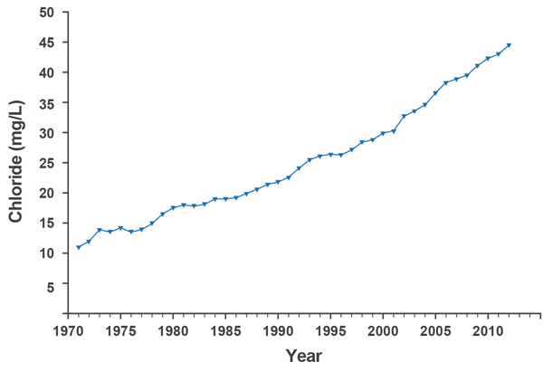
Figure 6: Chloride concentrations from 1971 to 2012 at the lake’s outflow (Atherley Narrows)
- The ministry is partnering with the LSRCA and local municipalities to raise awareness of the vulnerability of Lake Simcoe and its tributaries to chloride impacts. A key focus is on promoting the use of best practices to control snow and ice to commercial parking lot operators and road managers, balancing the need to reduce hazards, such as slipping on ice, with the need to protect the watershed ecosystem from de-icing chemicals like road salt. The project has already successfully:
- Mapped salt vulnerable areas in the Lake Simcoe watershed to support watershed municipalities in decision making about snow and ice controls based on location
- Provided training on snow and ice control practices that reduce the risk of road salt contamination to more than 100 individuals including municipal staff, facility managers, and private sector contractors with two new sessions planned in the fall of 2015
- Evaluated the likelihood of trained contractors to adopt snow and ice control best practices while recognizing the need to balance winter safety with environmental protection, and
- Monitored road salt application rates and measured chloride concentrations in surface water and stormwater in priority subwatersheds to better understand the cumulative effects of road salt transported to the environment, informing the development of best practices for snow and ice control.
- Contaminants of Emerging Concern
- The ministry has completed several monitoring and treatment technology evaluations for sewage treatment plants over the last 10 years and has monitored emerging contaminants in treated drinking water from Lake Simcoe. In 2013, we funded Trent University to conduct research on contaminants of emerging concern in the treated effluent of several sewage treatment plants that discharge to Lake Simcoe. The study looked at several indicator substances such as personal care products, pharmaceuticals, steroids and hormones and artificial sweeteners.
- The results indicated that while the sewage treatment process did not entirely remove contaminants of concern, sewage treatment plant discharges are not a significant source of these compounds in the Lake Simcoe watershed. More research is needed to compare these rates with other treatment technologies, and to understand the long-term impact these substances may have on the ecosystem.
- Pathogens – beach contaminants
- The Lake Simcoe watershed has an abundance of public beaches within 10 kilometres of most settled areas. A target in the Plan is to reduce the number of times that a beach is posted with a swimming advisory when it is suspected that pathogens might be present.
- Health Unit monitoring data shows that beach postings were uncommon along most of the shore of Lake Simcoe. From 2009–2012 there were fewer than 10 advisory postings along the north shore and in Kempenfelt Bay – all but one lasting fewer than 16 days. Along the southern and eastern shores of the main part of the lake (e.g., in York and Durham Regions), beaches were posted more often and for longer durations. The duration of postings at Durham beaches was the longest, partly due to weekly rather than daily retesting. Although the frequency of retesting has remained the same, the duration of postings at Durham region beaches has increased significantly since 1998.
- Research by Environment Canada, the University of Guelph and the ministry indicates that stormwater runoff, bird droppings and manure are potential sources of pathogens to these beaches. The researchers also found that changes in weather played a role in beach postings with the southern and eastern beaches of the lake more exposed to onshore winds and susceptible to storms.
- The ministry is working with Environmental Defence to promote Blue Flag Beach Certification for beaches in the watershed and has developed a “How to” Guide for achieving beach certification.
Ensuring Sufficient Water Quantity
Maintaining adequate water flows through the watershed is essential to the protection of ecological integrity and to meeting community water needs. Increased population and climate change can cause water quantity stress, resulting in changes in the aquatic habitats of rivers and streams and impacting aquatic communities. Certain subwatersheds are already under water quantity stress.
Plan Objective: protect, improve or restore the elements that contribute to the ecological health of the Lake Simcoe watershed, including hydrology
The province supports research to estimate how much water is stored in watershed streams and aquifers, and how water moves between these elements. Understanding the relationship between surface and groundwater is essential to ensuring there is sufficient water for multiple competing demands. Maintaining the flows necessary to preserve the habitat required by plants, fish and other organisms will protect aquatic ecosystems and build climate change resiliency.
- Water Budgets and Stress Assessments
- With provincial support, the LSRCA has completed water budget studies for every subwatershed in the Lake Simcoe basin. We now have groundwater flow models that help us improve our water resources management activities. These water budgets provide necessary information for subwatershed planning.
- In-stream flows
- The Plan supports research to estimate the reserve flows required to maintain healthy aquatic ecosystems in the watershed, and requires the development of in-stream flow targets for water quantity-stressed subwatersheds. A target and a low-flow threshold have been established for the Maskinonge River, a stressed and priority subwatershed. A framework for understanding environmental flows is being developed through a pilot project in the Lovers Creek Subwatershed. The project uses flow data from the ministry and the LSRCA to calibrate a model for use in other subwatersheds. Specific targets for protecting water quantity will be developed once the research has been completed.
- The LSRCA estimates the tributaries annually contribute 10 per cent of the total lake volume. The tributaries originating in the Oak Ridges Moraine along with the Talbot River contribute the greatest flow. The temporal discharge trends did not change significantly in the five tributaries for any season.
- Ecologically Significant Groundwater Recharge Areas
- Ecologically significant groundwater recharge areas are areas that provide water to ecologically-significant features, such as coldwater streams and significant wetlands. The LSRCA is working with the province to map these areas, and has completed mapping areas of high volume recharge for entire watershed.
- In early 2014, the LSRCA, together with MNRF, the ministry, and with input from watershed municipalities, developed guidance for managing ecologically significant groundwater recharge areas to assist municipalities in protecting and restoring these important areas.
- Water Conservation and Efficiency
- The Plan also promotes greater efforts to conserve and use water more efficiently in order to maintain future demands for water within sustainable limits. York Region’s “Water for Tomorrow” program offers residents information and rebates on selected water-saving appliances for businesses. Since 1998, York Region residents have saved 26 million litres of water per day with the support of the Water for Tomorrow program.
- Encouraging Low Impact Development
- LID provides a solution to both water quality and water quantity issues. LID approaches use a number of measures to manage runoff and keep it as close to its source as possible. This can start on individual properties using design features that manage runoff as much as possible, then at a broader scale, includes a treatment technology in the water course to deal with excess runoff. The result is a community that has more green space and native landscaping, and is more resilient to the effects of climate change.
Targeting Causes of Stress
Climate Change
The effects of climate change are already evident from the long-term monitoring programs on the Lake Simcoe watershed. The following are observations of the climate change indicators identified in the Plan:
- Meteorological trends: Annual air temperature from 1980 to 2012 has increased an average of 1.6 degrees Celsius in the watershed. Precipitation measured at the Barrie weather station was relatively unchanged over the 32-year period. Modelling results from Trent University predicted that overall annual average air temperatures could increase by 2 to 6 degrees Celsius by the 2070s in the Lake Simcoe watershed, but changes in precipitation will be variable.
- River Hydrology (flow of water in rivers): Preliminary analysis using climate projections indicate that flows in the tributaries may increase in the winter and decrease in the spring due to warmer winter temperatures causing smaller snow melt events, or rain-on-snow incidents. As the nutrient loads to the lake from tributaries are largely dependent on the amount of flow, this could have an effect on phosphorus loads. With support from the ministry, Trent University recently compared phosphorus loads and flow over a 30-year baseline (1968–1997) period to two modelled future periods: 2020–2049 and 2060–2089. Predicted changes to phosphorus loads in the rivers differed depending on soil type and geology, highlighting the importance of tailoring phosphorus reduction and adaptation approaches to individual watersheds.
- Lake Ice Cover: The direct effects of climate change are most apparent on the lake itself. Higher air temperatures are delaying the timing of surface freezing (ice-on) in the late fall or early winter, and promoting earlier thawing (ice-off) in the late winter or early spring, resulting in a shorter duration of ice cover. Since 1989 (when observations at Sibbald Point began), ice cover duration has been a full day shorter each year on average (see Figure 7). A shorter duration of ice cover lessens the safe on-ice time for anglers during the ice-fishing season.
- Lake Thermal Trends: In the summertime, a lake naturally stratifies into layers of water of different temperatures; colder water is denser and sinks to the bottom while warmer, lighter water floats at the surface. Stratification starts in the spring after the ice has melted from the lake surface and ends in the fall when waters cool down and mix from top to bottom. Because air temperatures are getting warmer in the spring and the fall the lake is stratifying earlier in the spring and mixing later in the fall. This has resulted in a longer duration of stratification; for example, in Kempenfelt Bay, the duration of thermal stratification was 28 days longer on average in 2012 than it was in 1980.
- Timing of Seasonal Processes: The observed changes in lake ice cover and thermal structure can affect the timing of seasonal processes for biota due to an earlier exposure to light and wind, and increases in temperature. Research has shown that during the spring, lake trout spawning appears to happening later, and that a mismatch might be occurring between phytoplankton and zooplankton abundance peaks that could have effects on fish recruitment.
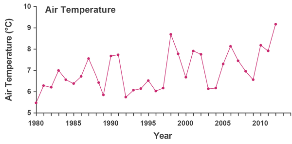
Figure 7a: Annual climate change indicators for Lake Simcoe from 1980-2012. Increase in air temperature measured near Barrie.
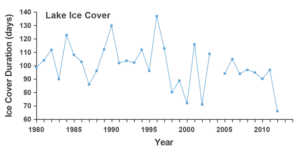
Figure 7b: Annual climate change indicators for Lake Simcoe from 1980-2012. Decrease in duration of ice cover observed from Barrie.
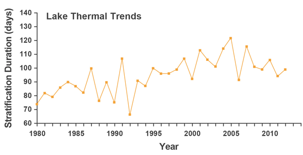
Figure 7c: Annual climate change indicators for Lake Simcoe from 1980-2012. Increase in duration of summer thermal stratification in the main basin.
Climate model projections indicate the potential for significant change in ecosystem function in natural heritage areas and subsequent effects on nature-based tourism, resulting in many possible management implications. For example, climate conditions that provide habitat for boreal species such as black spruce are projected to disappear while those ideal for more southerly species such as willow oak are projected to develop in the Lake Simcoe area. Projections from climate models point towards substantial reductions in the length of ice fishing, alpine and Nordic skiing, and snowmobiling seasons.
In addition, increased frequency and intensity of extreme weather events such as flooding, drought, and windstorms as well as wider distribution and increased abundance of invasive species could affect human health and safety and the condition of natural heritage areas throughout the watershed. To reduce the negative impacts of this change and to take advantage of any new opportunities presented, local municipalities will need to adapt.
Plan Objective: improve the Lake Simcoe watershed’s capacity to adapt to climate change.
Actions taken to protect natural heritage, reduce stormwater and phosphorus, improve water conservation, build the capacity for on-site infiltration and retrofit aging infrastructure all help build resiliency in the watershed, and increase the local capacity to adapt.
Climate Change Adaptation
The ministry is developing a Climate Change Adaptation Strategy for the Lake Simcoe watershed to help local governments and First Nations and Métis communities manage the effects of climate change. A draft Lake Simcoe Climate Change Adaptation Strategy was posted for public comment on the Environmental Bill of Rights Registry on October 31, 2013.
The province has since released a change discussion paper and held public consultation sessions across the province. The results of these consultations will be incorporated into the Lake Simcoe Climate Change Adaptation Strategy.
The ministry is working with its partners to build resilience of the Lake Simcoe watershed to climate change in the following areas:
- The ministry has supported the creation of an online Community of Practice to encourage practitioners to share information and support the integration of climate change adaptation into decision-making. Visit the Ontario Centre for Climate Impacts and Adaptation Resources online Community of Practice.
- The ministry worked with partners to conduct Vulnerability Assessments to determine which natural systems are most vulnerable, by identifying key risks, and ‘best-bet’ options for adapting to those risks.
- The ministry is partnering with local universities and leading research institutions to develop regionally-focused climate data.
- The ministry is supporting York University on a project to understand the impacts of climate change on algal growth in the watershed.
- OMAFRA supported a project managed by the Mining Innovation Rehabilitation and Applied Research Corporation to develop agricultural and rural components of the Climate Change Adaptation Strategy and deliver a workshop to help farmers understand climate change.
- The Chippewas of Georgina Island First Nation is taking action to address climate change at a local level by developing a climate change adaptation plan for their community that is informed by local traditional ecological and community knowledge.
Invasive species
Invasive species, those that are not native to the watershed, are another stress to the Lake Simcoe watershed. There are currently 48 invasive species detected in the watershed: 32 land-based (e.g., emerald ash borer) and 16 aquatic invasive species (e.g., spiny water flea, dreissenids and round goby, among others). Some have already had a significant effect on the lake’s ecosystem and its food web. The proximity of Lake Simcoe to the Great Lakes results in the Great Lakes being a principal source of aquatic invasive species.
Plan Objective: respond to adverse effects related to invasive species and, where possible, to prevent invasive species from entering the Lake Simcoe watershed.
Through some of the ongoing aquatic monitoring programs and/or research efforts, detailed information is available for Lake Simcoe on four invaders:
- Zebra mussels invaded the lake in 1992 and the quagga mussel was first detected in Lake Simcoe in 2004. The zebra mussel abundance appears to be declining and the quagga mussel has apparently increased, especially at deepwater sites. A possible reason is predation by round goby. However more monitoring and research is needed to confirm the shift and determine the cause and the potential ecological effects.
- The round goby is a small, bottom-dwelling fish spotted in the watershed in 2004 and fully established in the lake by 2010. The round goby can negatively affect native fish species by outcompeting for food as well as eating their eggs and young.
- The spiny water flea is a species of zooplankton, which are small crustaceans that inhabit the open water of lakes. It was first observed in Lake Simcoe in 1993 and was well established in the lake by 1994. Since 1999 its abundance has shown an apparent decrease.
The terrestrial or land-based invasive species threatening the ecological health of the Lake Simcoe watershed include a variety of vascular plants, animals (including insect forest pests) and disease. The Lake Simcoe watershed has a history of terrestrial invasive species becoming established, starting in the 1960s or earlier.
- Several invasive species are well-established and widespread in the Lake Simcoe watershed. Invasive tree species include common buckthorn, Manitoba maple and Norway maple, and invasive vascular plant and shrubs species include garlic mustard, dog strangling vine, and giant hogweed.
MNRF is working with its partners to limit the spread and reduce the impact of invasive species. Actions include:
- Undertaking research to identify high-risk areas and pathways and developing outreach/education targeting these pathways.
- Created and shared a Watch List poster for invasive species in the watershed to identify the species with the greatest potential to be introduced or to spread into the watershed.
- Teaching the value of washing your boat and not dumping bait, through the Operation Boat Clean and Operation Bait Bucket Campaigns. Research indicates boaters/anglers are a significant potential pathway for the spread of invasives to Lake Simcoe. In the summer, mobile boat wash units were located at various access points around the lake for boaters to clean vessels entering and leaving Lake Simcoe. In 2013, one permanent boat washing station was established at the City of Barrie Marina.
- Updating and posting invasive species signage along highways and other locations to encourage sustainable bait management and sound natural resource practices.
- Holding invasive plant workshops for landowners and making available a Landowner’s Guide to Managing and Controlling Invasive Plants.
- Supporting local non-governmental organizations in their efforts to remove terrestrial invasive species.
- Working with the Ontario Federation of Anglers and Hunters to make EDD maps (Early Detection and Distribution Mapping System), a system for real-time tracking of invasive species occurrences, available in the watershed. The system provides information to identify invasive species, and encourages people to submit early detection reports electronically. The information is then uploaded to local and national distribution maps so everyone can see where the hotspots are.
There are several other citizen science programs in Ontario and many of them are active in the Lake Simcoe watershed. Each program adds value to the monitoring programs conducted by provincial and federal governments and conservation authority scientists.
Protecting and Restoring Important Natural Areas
Promoting and protecting the ecological health of the lake’s shoreline and the watershed’s natural heritage are important to fostering a resilient, adaptable and sustainable watershed.
Threats to natural heritage features such as climate change can lead to drastic and detrimental changes such as drought and flooding, shifts or loss in biodiversity, changes in species composition and unknown impacts to wetland functions.
Plan Objective: protect, improve or restore the elements that contribute to the ecological health of the Lake Simcoe watershed, including … key natural heritage features and their functions, and key hydrologic features and their functions.
Shorelines and Streambanks
Shorelines connect land and water and are important to fostering a resilient, adaptable and sustainable watershed. Natural shorelines prevent erosion, filter contaminants, and provide key habitat for native species, as well as recreational opportunities.
There is more than 300 kilometres of shoreline around Lake Simcoe, with natural surfaces ranging from stone and sand to nutrient rich organics with diverse wetland and aquatic plant communities. The Plan calls for no further loss of Lake Simcoe shoreline, and more naturalized shorelines along the lake and its tributaries. Progress will be measured by the amount of shoreline that is undeveloped, naturalized or maintained in a naturalized state.
An increase in urban and rural development and recreational uses in the watershed has caused significant alteration to the shoreline. MNRF conducted a comprehensive inventory of the Lake Simcoe shoreline in 2008-09.
Of the 358 kilometres of shoreline classified, over half was found to be in an altered state. The rest of the shoreline was a mix of natural vegetative cover (39 per cent), open beach/bar (10 per cent) and undetermined (Figure 8). In total, there were over two thousand shoreline and nearshore structures in Lake Simcoe. The majority of these structures were docks followed by marinas and boathouses, with boathouses having the largest footprint on the lake.
This inventory provides a baseline for the state of the Lake Simcoe shoreline when the Plan was released. To report on the targets and indicators of the Plan, this inventory should be repeated at a regular interval of 5–10 years to allow for the monitoring of land use change and shoreline naturalization over time.
In 2014, MNRF acquired oblique imagery of Lake Simcoe shoreline, to complement existing orthophotography for the improved interpretation of shoreline features and the updating of shoreline mapping. The imagery will also provide a snapshot in time, capturing the current condition of the Lake Simcoe shoreline. This information is now available on Land Information Ontario.
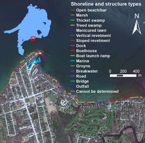
Figure 8: Shoreline inventory: digitized shoreline of Jackson’s Point
MNRF is leading the development of a Shoreline Management Strategy that will address best management practices for the shoreline including restoration, protection and land use planning. Upon completion of the Shoreline Management Strategy, municipal official plans will be amended to ensure they are consistent with the recommendations of the strategy. To support the implementation of the strategy, the province is working with local partners to:
- Provide guidance on shoreline protection for landowners, contractors and municipalities. Developed by the MNRF in partnership with Dufferin Simcoe Land Stewardship Network, a Landowner’s Guide is available. The “Professional’s Guide to Healthy Shoreline Management for Lake Simcoe” is available. The development of the municipal guide is underway.
- Pilot demonstration projects for ecologically sensitive approaches to shore protection and shoreline structures. For example, MNRF is piloting a ‘live siltation’ project at the north beach of Beaverton Harbour in Brock Township that uses native plants to encourage the natural colonization of the beach’s upland areas.
- Deliver OMAFRA’s Water’s Edge Transformation pilot project to protect streams, shorelines, wetlands, ponds or rivers on farm properties. To date, five riparian projects have successfully reduced erosion around livestock intensive areas, protecting a designated provincially significant wetland and reducing phosphorus loading to the watershed’s tributaries.
- Establish a 2.5 metre vegetative buffer (where feasible) along both sides of the Holland River Municipal Drain to reduce soil erosion and nutrient runoff.
- Restore streambanks and shorelines through the LSRCA’s Landowner Environmental Assistance Program. Since 2009 LSRCA has provided technical and financial support through this program to implement over 150 restoration projects in the watershed. These have included the planting of native trees and shrubs, installation of cattle restriction fencing, removal of instream barriers and online ponds, and the use of bioengineering solutions as part of natural channel designs. Collectively, these have contributed to improvements in habitat for native species, expanded riparian cover, and reduced sediment and nutrient inputs to the lake.
Protecting Natural Heritage and Key Hydrological Features
A key goal of the Plan is to protect, improve and restore the elements that contribute to the watershed’s ecological health. These include wetlands, significant woodlands, significant valleylands and natural areas abutting Lake Simcoe, such as wetlands, permanent and intermittent streams.
Natural cover in the Lake Simcoe watershed is facing considerable stress from fragmentation and degradation due to invasive species, as well as development, climate and environmental change. There have been significant increases in human population growth and urbanization, and almost half of the watershed is being used for agriculture.
MNRF, with key partners, has mapped and identified key natural heritage areas, shorelines, wetlands and woodlands. Since 2009 the following data layers have been mapped and posted to the Land Information Ontario:
- Landscape level data for woodlands and wetlands
- Natural areas abutting Lake Simcoe
- Shoreline characteristics (e.g., per cent natural), and
- “High quality” natural cover areas in the watershed (natural areas greater than 25 hectares in size).
MNRF captures large scale information through orthophotography (aerial photos) to estimate how much terrestrial vegetation is in the watershed, and digitizes the information through the Ecological Land Classification, which is available to the public on the Land Information Ontario website. The last orthophotography was captured in 2012-13, and is in the process of being digitized, verified, and analyzed to compare gains and loses across watershed since the launch of the Plan.
The Plan establishes a target of 40 per cent high qualitynatural vegetative cover in the watershed, and targets the achievement of greater proportion of natural vegetative cover in large high quality patches. Although the watershed as a whole has 35 per cent natural cover, the amounts vary by subwatershed. Eight of the 21 subwatersheds in particular having low amounts of natural cover (below Environment Canada’s Natural Heritage guidelines). The amount of natural cover within riparian zones was below guidelines in all subwatersheds. While the amount of wetland cover met the guideline level in almost all subwatersheds, there is a need to improve and protect wetland coverage, because wetlands are ecologically important and are excellent phosphorus filterers.
Three subwatersheds had less than 20 per cent natural cover: Maskinonge River, and Hewitts and Barrie Creeks. A minor decline in the amount of natural cover in these subwatersheds may result in dramatic changes in biodiversity and ecological functions of vegetation, including impacts on water quality.
Reliable site level information (e.g., vegetation structure, species composition and age) is currently not available to indicate how much of that 35 per cent is ‘high quality’. We know that much of it exists in a fragmented state and is facing considerable stress from degradation due to invasive species, development, climate and environmental change.
In order to better gauge the quality of these natural areas as habitat for sensitive elements of biodiversity, MNRF and the ministry are working with the University of Toronto to establish a terrestrial site-level monitoring approach for the Lake Simcoe watershed.
With terrestrial monitoring we will be able to determine the proportion of high quality natural vegetative cover, and make forecasts that would allow the implementation of timely watershed management actions. This work will inform the necessary frequency, location and choice of long-term monitoring parameters that are critical for understanding the terrestrial ecosystem and its connection to the lake, and will also give us valuable information on the status of invasive species.
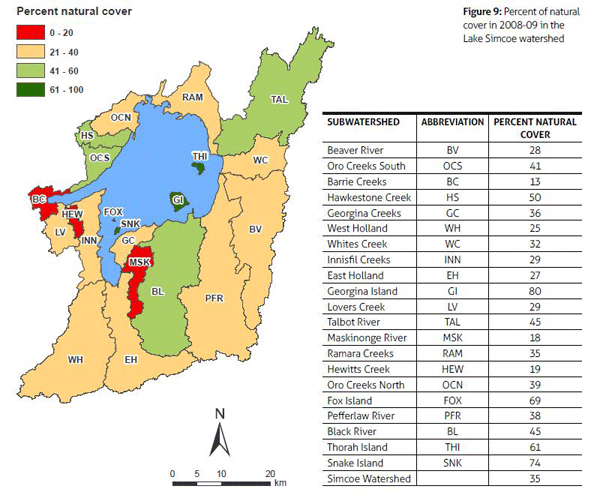
Figure 9: Percent of natural cover in 2008-09 in the Lake Simcoe watershed.
Data download for figure 9 available in csv format.
The province is working closely with watershed municipalities, the LSRCA, Ontario universities and non-profit organizations such as Ducks Unlimited, Ontario Streams, Dufferin Simcoe Land Stewardship Network, and Nottawasaga Community Economic Development Corporation to implement the Plan’s natural heritage policies.
- In 2013, MNRF worked with partners to develop technical papers to assist municipalities with identifying and protecting their key natural heritage and key natural hydrologic features. These papers provide important information to assist in the interpretation and application of the policies in the Plan pertaining to natural heritage features.
- Through the subwatershed planning process, we are mitigating further loss of natural areas. For example, the Oro Creeks Subwatershed Plan recommended that the LSRCA and subwatershed municipalities develop Official Plan policies to mitigate loss of natural heritage features that are not defined as “key” or “significant”, to ensure no net loss in overall vegetative cover. The LSRCA is currently working on guidelines for mitigation policy.
- In collaboration with MNRF and Kawartha Conservation, the LSRCA is prioritizing restoration efforts and is identifying areas of greatest potential gains for:
- Protecting cold water streams
- Reducing phosphorus loads
- Increasing shoreline cover
- Increasing overall natural heritage cover
- Decreasing fragmentation, and
- Mitigating climate change.
- Since 2009, more than 342,000 trees have been planted and more than 15 kilometres of streambank and shoreline restored under the LSRCA’s Landowner Environmental Assistance Program.
- The subwatershed planning process also helps promote wildlife passage. Also in the Oro Creeks Subwatershed Plan, it was recommended that Environmental Assessments give due consideration to the preservation of barrier-free connectivity for wildlife. The LSRCA hosted a Wildlife Passage workshops in 2014 with municipalities to discuss the planning process, existing hotspots and case studies and other mitigation tools.
Priorities for Local Action
A key principle guiding our implementation of the Plan is the subwatershed approach. This approach considers the area-specific hydrologic, hydrogeologic functions and natural heritage resources (e.g., wetlands, woodlands and fish habitat). Local priorities are incorporated into the development of Subwatershed Plans. Through a consultative process, stakeholders define targets and local priority actions required to conserve and restore ecological functions (e.g., stormwater retrofits, aquatic habitat restoration, etc.).
- With support from watershed municipalities and the province, the LSRCA has developed Subwatershed Plans for all priority subwatersheds. All subwatersheds will have Plans by the end of 2016, as the final two are currently being prepared: Ramara Creeks (for completion in 2015), and Whites Creek and the Upper Talbot (for completion in 2016).
- In addition, the ministry is working with the Chippewas of Georgina Island First Nation, the LSRCA, and the Ontario Centre for Climate Impacts and Adaptation Resources to develop a Subwatershed Plan for Georgina, Snake and Fox Islands. This plan will incorporate Traditional Ecological Knowledge of climate change impacts to address risks associated with climate change.
The LSRCA and MNRF are working in each subwatershed to develop tools to identify restoration priorities.
- The MNRF is working with partners to identify wetland, riparian and other natural heritage areas most in need of restoration. Starting with the East Holland subwatershed, the mapping initiative is focused on identifying the linkages/corridors that have little or no natural cover vegetation and riparian areas that are below the 75 per cent riparian vegetation recommended for a functioning system. This information will assist municipalities, stewardship and other organizations with identifying priority areas for restoration.
- With the support of the federal and provincial governments, the LSRCA has mapped over 3,000 locations in the watershed where stewardship projects could improve fish habitat and reduce phosphorus loading in Lake Simcoe’s tributaries.
Encouraging Local Action
Great Lakes Guardian Community Fund in Lake SimcoeThe province’s Great Lakes Guardian Community Fund provides grants of up to $25,000 to help communities, including those in the Lake Simcoe watershed, take action to protect and restore the watersheds in the Great Lakes and St. Lawrence River Basin.
- In the Lake Simcoe watershed, this program has funded 15 projects with a provincial investment of $340,642.
- Projects ranged from wetland restoration, community festivals, urban stewardship programs, invasive species control, aquatic and riparian habitat restoration, species at risk, beach naturalization, community stormwater management, and community outreach and education.
Stewardship, education and outreach activities help us understand our cumulative influences on the watershed, and encourage everyone to voluntarily take responsible and sustainable action. By engaging local businesses, government, community groups and landowners, we can ensure lasting positive change in the Lake Simcoe watershed.
- The Lake Simcoe Stewardship Network continues to thrive since its launch in 2010. The network brings citizens, business, industry, educators and all levels of government together to share stewardship and conservation knowledge, ideas and accomplishments. It also encourages partnerships and opportunities that support the Plan’s stewardship objectives. The Helping Lake Simcoe section of the OurLakeSimcoe.com website has been redeveloped to engage partners, profile their work and share success stories, identify restoration priorities and share technical information.
- Three programs operate in the watershed to support landowners, community groups and local governments to support of Plan objectives:
- MNRF’s Lake Simcoe Community Stewardship Program ran from 2009 to 2012 and provided financial and technical support to watershed landowners. Led by Dufferin Simcoe Land Stewardship Network, this program is now known as the Lake Simcoe and Georgian Bay Stewardship Program. With federal and provincial support, the program continues to motivate and provide financial incentives to local landowners and community groups to improve water quality.
- OMAFRA’s Lake Simcoe Farm Stewardship Project ran from 2009 to 2012. During this time, farmers in the Lake Simcoe watershed were trained on the Environmental Farm Plan and created action plans for their farms to identify on-site environmental projects. With provincial and federal funding to offset the project costs, farmers were able to build manure storage facilities, control runoff and erosion, modify equipment, and manage water wells. Figure 10 illustrates the top 12 on-farm best practices implemented under the Lake Simcoe Farm Stewardship Program.
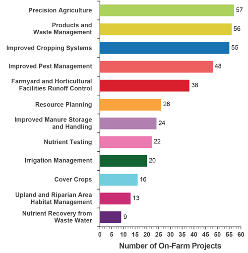
Figure 10: Top 12 On-farm best management practices implemented under the Lake Simcoe Farm Stewardship Program (2008-2012)
Data download for figure 10 available in csv format.
- The LSRCA’s Landowner Environmental Assistance Program, an ongoing watershed-wide program that started in 1989, offers watershed residents the opportunity to improve water quality and wildlife habitat. The program offers financial incentives to watershed residents, and opportunities for collaboration with other agencies on environmental projects. The program is funded by watershed municipalities and investments leveraged by external funding partners (e.g. Lake Simcoe Conservation Foundation, provincial and federal programs, others). More than $22.4 million has been invested in projects since 2009 resulting in a reduction of over 1.4 metric tons of phosphorus annually.
- The collective stewardship action that occurred from 2009 to 2012 under these three programs, has resulted in many significant accomplishments:
- More than 1,500 restoration projects completed across the watershed ranging from private landowner projects to large-scale community projects.
- More than 181,000 trees and shrubs have been planted.
- More than 10,000 metres of shoreline/stream bank have been stabilized, including a live stake shoreline planting to enhance shoreline stabilization projects, and a shoreline planting blitz completed in Innisfil to stabilize the shoreline.
Connecting People to Nature
As the population in southern Ontario continues to grow, demand for recreational activities will increase. Without careful planning, recreational activities have the potential to impact water quality, water quantity, aquatic life and the spread of invasive species. A major challenge for the Lake Simcoe area is how to provide quality recreational opportunities while minimizing congestion, conflicts between competing uses and users, and impacts to the natural environment.
Plan Objective: improve conditions for environmentally sustainable recreation activities related to Lake Simcoe and to promote those activities.
The province is fostering sustainable, low-impact opportunities to enjoy the lake in ways that encourage more people to value and protect it.
The Ladies of the Lake Conservation Association, now part of the Ontario Water Centre, with support from the ministry, conducted research in 2013 on the best ways to engage shoreline residents and communities and encourage practices that lead to healthy shoreline stewardship. The research has pointed to the need for innovative ways to inspire people through new forms of community action.
With support from both the provincial and federal governments the Ontario Water Centre is taking this knowledge and is piloting an approach to “re-wilding” that builds capacity for people to improve the built environment, public greenlands and waterways. The project will create three ‘incubators’ – one for citizen science, one to showcase natural design, and one to develop new creative ways to measure and showcase success.
The province has further helped connect people to nature by:
- Helping the Ontario Water Centre develop an innovative toolkit that will help the public ‘re-wild’ and restore under-valued shoreline environments.
- Better understanding what motivates businesses to adopt environmentally sustainable tourism practices through research at Ryerson University.
- Helping local tourism businesses develop and implement green business strategies based on a Sustainable Tourism Toolkit and Greening Guides developed by Tourism Barrie.
- Encouraging festival organizers to manage environmental impacts of festivals with Ryerson University’s Festival Greening Guide. To date, Ryerson has worked with the Mariposa Festival and Brock Big Bite Festival looking at waste generation, energy and water use.
- Connecting residents and visitors to sustainable recreational experiences in the Lake Simcoe watershed on the Ontario Water Centre’s OurLakeSimcoe.com website.
- Restoring wild rice, a culturally significant native plant, through a planting partnership between MNRF and the Chippewas of Georgina Island First Nation.
- Engaging youth in the watershed – through MNRF’s Stewardship Youth Ranger program, youth implement natural resource management projects in the Lake Simcoe watershed. Young people have created habitat, removed invasive species, and participated in cultural and community events. Also, the Chippewas of Georgina Island First Nation and the MNRF have set up a small classroom hatchery in an aquarium to educate youth on the Lake Simcoe’s ecosystem, biodiversity, and the Plan.
Advancing and Sharing Knowledge
The Lake Simcoe Protection Plan must adapt to what we learn from ongoing scientific research and monitoring in the watershed. Collectively, the key research and monitoring actions required in the Plan help improve our understanding of how the watershed functions, increase our ability to detect changes in the natural environment and inform the adaptive management approach used in the Plan.
Plan Objective: provide for ongoing scientific research and monitoring related to the ecological health of the Lake Simcoe watershed.
The province has implemented several key priorities in the first five years of the Plan’s implementation:
- The ministry worked with partners to develop a comprehensive monitoring strategy for the Lake Simcoe watershed that was released in 2015 as a companion to the 2014 Monitoring Report. A multi-agency comprehensive monitoring strategy working group found that many important indicators identified in the Plan are monitored. The strategy also included recommendations for monitoring, as well as management and reporting, of ecological data. These are informing our priorities for the next five years.
- There are approximately 100 researchers and monitoring groups working in the Lake Simcoe watershed. Their investigations cover a wide range of the aspects of the ecological health of the watershed from water quality, fish communities and other aquatic life, agricultural best management practices, innovative infrastructure, and forest management, to name a few. To bring these groups together, the ministry, MNRF, OMAFRA and the LSRCA have partnered to host two biennial Lake Simcoe Science Forums in 2011 and 2013. The third Science Forum will take place in November 2015 and will be integrated as a one-day session stream dedicated to Lake Simcoe within the Latornell Conservation Symposium, one of Ontario’s premier environmental events.
- Two special issues of scientific journals in 2011 (Journal of Great Lakes Research) and 2013 (Journal of Inland Waters) were released. These journals focus on the research and monitoring underway in the Lake Simcoe watershed.
- Provincial staff and partners have co-chaired four special sessions on Lake Simcoe at the International Association for Great Lakes Research’s Conference in 2008, 2010, 2012 and 2014. The sessions included presentations on findings from Lake Simcoe monitoring and research, facilitating the transfer of scientific information and knowledge in our efforts to protect the ecological health of Lake Simcoe and its watershed.
Summary
Ontario is working with its partners to protect and restore Lake Simcoe. We have deployed a variety of innovative and adaptive tools to implement the Plan. Our efforts have included:
- Direct management action and regulatory controls
- On-the-ground restoration action with community partners
- Support for landowners as stewards of the watershed
- Encouraging innovation through targeted research
- Extensive monitoring to track our collective progress, and
- Education and outreach to engage and motivate those who live, work and play in the watershed.
Together we have moved closer toward achieving the Plan objectives and have made significant progress towards the key priority areas identified for the first five years of Plan implementation:
- Restoring aquatic life:
- Levels of dissolved oxygen at the end of summer have significantly improved since the 1980s
- Lake trout, lake whitefish and cisco (lake herring) are showing signs of recovery, and
- We now have enhanced monitoring and research programs to better inform fisheries management decisions.
- Improving water quality and reducing phosphorus:
- Total phosphorus has decreased significantly in most of the watershed rivers and streams since the 1990s
- We have set targets for phosphorus loading from significant sectors such as agriculture, streams and tributaries, and sewage treatment plants
- Loadings from point sources, such as sewage treatment plants, have been reduced despite significant population growth
- Farmers and rural landowners have implemented best practices on 440 on-farm projects to reduce phosphorus runoff into rivers and streams and improve wildlife habitat
- Developers and municipalities are changing their land management and development practices to provide longer-term environmental benefits, and
- We are working with our partners on solutions to combat the increase in chlorides from winter road salt use due to urbanization.
- Improving the ecosystem by protecting and rehabilitating shorelines and natural heritage areas:
- Watershed municipalities now have the tools necessary to evaluate and protect local natural heritage features
- Over 1,500 restoration projects have been completed, and more than 181,000 trees and shrubs have been planted across the watershed, and
- With the help of our comprehensive mapping and monitoring activity, we are developing a Shoreline Management Strategy that will address shoreline restoration and protection. Currently, more than 10,000 metres of shoreline/stream bank have been stabilized.
- Addressing the impacts of invasive species, climate change and recreational activities:
- We have observed the effects of climate change on air temperature and ice cover. We support local municipalities and First Nations groups in their climate change adaptation planning. By identifying infrastructure retrofits and promoting low impact development to control runoff, we are helping to increase the watershed’s resiliency to climate change
- We have established invasive species watch lists, identified high-risk pathways and implemented programs to prevent their spread and the introduction of new invasive species to the watershed, and
- We have studied the barriers to adopting sustainable recreation practices and are working with local stakeholders to overcome them.
Beyond 2015, we will continue to assess and modify our approaches based on implementation experience and the evidence collected though our monitoring and research programs.
We will continue to evaluate incremental improvements, reflect on and celebrate local successes, and evaluate and promote new innovations.
Our efforts over the next five years will include a focus on promoting innovation – both social innovation (e.g. new ways to provide information to watershed residents and visitors) and technological innovation (e.g. phosphorus recovery opportunities).
We will continue to support the implementation of local priorities identified in Subwatershed Plans.
We will work closely with municipalities and stakeholders to continue implementation of the Plan, including the roll-out of the Lake Simcoe Climate Change Adaptation Strategy and the Lake Simcoe Shoreline Management Strategy.
The Lake Simcoe Protection Plan builds on the protections for the watershed that are provided under provincial land use plans that apply in all or part of the Lake Simcoe watershed. These include the Oak Ridges Moraine Conservation Plan, the Greenbelt Plan and the Growth Plan for the Greater Golden Horseshoe. These plans work together to manage growth, protect the natural environment and support economic development in the watershed.
The legislated 10-year review of these provincial land use plans is currently underway. Lessons learned during the implementation of the Lake Simcoe Protection Plan will inform the broader review of these plans. Similarly, the results of the coordinated plan review will inform the review and update to the Lake Simcoe Protection Plan, required by 2019.
We will work with partners to identify new and emerging priorities and opportunities, as per the adaptive management principle of the Plan.
Lake Simcoe is an example for other watershed improvement efforts across the province.
We have made progress, but there is still much work to do.
As we continue to work with our partner agencies to develop solutions for protecting and restoring Lake Simcoe, we will also apply these best practices to our work in the Great Lakes and other watersheds in the province.
Appendix: advice from the minister’s advisory committees
Two publicly appointed Committees were established in 2010 under the Lake Simcoe Protection Act – the Lake Simcoe Coordinating Committee and the Lake Simcoe Science Committee. These committees provide advice to the Minister of Environment and Climate Change on the implementation of the Lake Simcoe Protection Plan and the ecological health of the Lake Simcoe watershed. The government recognizes and thanks all committee members for their commitment to Lake Simcoe and for providing us with their best advice.
A. Lake Simcoe Science Committee
As required in the Act, a Science Committee was created in 2010 to review progress on environmental indicators and provide advice on an ongoing basis. As a result, scientific evidence and advice that reflects a broad range of expertise play an important role in decisions about the lake and watershed.
In 2012, the Lake Simcoe Science Committee prepared a full report with 41 recommendations for the Minister. The report celebrated the important advancements made towards the implementation of the Plan, recent advancements in applied science, and the strong partnerships built. Since then, six additional recommendations have been composed, which have been communicated via Lake Simcoe Science Committee meeting minutes.
Key themes of the advice to the Minister from the Lake Simcoe Science Committee to date:
- Continue to focus on reducing phosphorus loads, especially in light of projected population growth. Twenty recommendations have been made relating to the reduction of phosphorus loads to the tributaries and lake. For example,
- Continue to promote the development and implementation of innovative approaches to reduce phosphorus loads
- Promote implementation measures, in partnership with the municipalities, to reduce phosphorus inputs from urban stormwater and new urban developments
- Improve the characterization of non-point phosphorus sources and promote and facilitate the necessary actions that need to be taken to address them.
- Continue to increase the protection and re-naturalization of shoreline and natural heritage areas, with nine recommendations, including:
- Completing a comprehensive inventory of shorelines, and
- Protecting all wetlands
- Other threats: invasive species and climate change. Four recommendations were made, including:
- Release the Climate Change Adaptation Strategy and commit to the strategic directions outlined, and
- Develop a rapid response plan to invasive species.
- Continue a comprehensive water quality monitoring program to better understand and reduce the risk of emerging water contaminants. Recommendations were made on:
- Monitoring pharmaceuticals and contaminants of emerging concern
- Identifying sources of pathogens and reducing levels at beaches
- Continuing to support projects to reduce winter salt application rates including research management options and policy gaps, and
- Monitoring iron in stormwater retrofit ponds
- Continue leading edge research and monitoring activities and improve where needed, with eight related recommendations including:
- implementing recommendations in the comprehensive monitoring strategy such as the implementation of natural heritage monitoring programs.
- Transfer scientific information to policy makers, stakeholders and the public in plain language. Three recommendations were specific to communication, such as:
- Developing communication materials to engage and inform public, and
- Creating a dedicated webpage to host reports and information about Lake Simcoe and the Science Committee in particular.
B. Lake Simcoe Coordinating Committee
A multi-stakeholder coordinating committee representing a variety of interests in the watershed was established in 2010 to provide advice to guide the implementation of the Plan. The Lake Simcoe Coordinating Committee meets quarterly to provide advice to the Minister on the implementation of the Plan and on the types of measures that could be taken to deal with the threats to the ecological health of the Lake Simcoe watershed, including policies that could be included in the Plan or regulations that could be made under an Act.
In addition to regular advice provided to provincial staff during committee meetings, four advice notes (2011-2014) have been submitted to the Minister with recommendations to support the Plan’s implementation. Advice provided by the committee informs the adaptive management process. Key themes have included:
- Continued provincial investment to support the implementation of the Plan
- The committee recognized progress on a variety of goals in the initial Plan, and commended all levels of government for their investments to improve the health of the lake.
- Noting that much still remains to be done, the committee recommended continued multi-year funding for lake protection and restoration, especially in the face of projected population growth in the watershed.
The province has continued its commitment to take strong action to protect and restore the ecological health of Lake Simcoe and its watershed.
- Growth and development
- Recognizing that the growth that is already approved in the watershed could increase phosphorus loading substantially, the committee recommended that the province support efforts to reduce the area of impervious surface, and control stormwater flows from individual lots.
- Impacts of growth need to be closely monitored and requirements strengthened for ‘greener’ development, such as low impact development, innovative sewage treatment, linkages with subwatershed plans and provisions in environmental assessments for infrastructure.
Working closely with the LSRCA, local municipalities, developers, and landowners, the ministry is supporting innovative approaches to land development (or re-development) that will help mitigate the impacts of approved growth.
- Stewardship
- Continued promotion of stewardship, education, and identification of priorities are needed to promote collective cumulative action and behavior change. The committee recommended that the province continue to support the strategic coordination of MNRF, LSRCA and OMAFRA stewardship and remediation actions.
The Lake Simcoe Stewardship Network continues to seek innovative ways to engage the community in stewardship activities since its launch in 2010. The province continues to support the Network through the OurLakeSimcoe.com portal, where Network members can share information and learn more about the good work underway in the watershed. As per the adaptive management principle of the Plan, the province continues to assess and modify our approaches based on implementation experience and monitoring evidence.
- Innovation
- The committee reiterated the need for innovative solutions to reducing phosphorus, and achieving the overall targets in the Plan. Continued science and planning studies are essential to fine tune actions and ensure goals are monitored, measured and achieved. Innovation should not be limited to technological innovation – social and economic innovation tools are essential as well.
The province continues to encourage innovation through targeted research, including support for social and economic innovation to inspire change.
- Protecting Green Space
- Recognizing that it can be difficult for smaller municipalities to keep track of the many environmental and land use plans they must follow, the committee recommended that the protection of natural heritage systems would be strengthen by requiring natural heritage maps in Official Plans.
This recommendation was shared with the Ministry of Municipal Affairs and Housing and addressed through the updated Provincial Policy Statement (2014).
- Shoreline Protection
- The committee recognized that there were potential opportunities for efficiency in shoreline protection legislation, between the Conservation Authorities Act (Ontario Regulation 179/06), the Lakes and Rivers Improvement Act, the Public Lands Act and the Beds of Navigable Waters Act.
A working group has been formed to investigate which shoreline alteration problems persist and how to most effectively enforce existing rules.
- Support for Municipal Implementation
- The committee recommended that the province provide support for local municipal implementation of the Plan by enhancing outreach, collaboration and information sharing with municipalities.
In 2015, the ministry consulted with municipalities on the scope and potential priorities for a municipal toolkit on Plan implementation anticipated for release in 2015-16, and continues to work with the LSRCA to support municipal implementation in priority areas.