Proposed new fishing rules on the lower Ganaraska River
Share your feedback on proposed changes to recreational fishing rules on the lower Ganaraska River.
This survey closed on August 22, 2024 — midnight.
Overview
We are proposing a recreational fishery rule change to the lower Ganaraska River in Fisheries Management Zone 17.
The changes will:
- help protect vulnerable migrating Chinook salmon during peak migration
- provide extended angling opportunities for Atlantic salmon, brown trout, Pacific salmon, and rainbow trout in the fall season
This proposal is only about the recreational fishery. It does not affect Indigenous communities exercising their constitutionally protected rights to fish.
Ganaraska River fall salmon migration
In some years, over 30,000 Chinook salmon migrate through the lower Ganaraska River in Port Hope on their way to spawning habitat upstream. This makes the migratory run in the Ganaraska one of the largest in Ontario.
This population is:
- naturally sustained through wild production, meaning there is no supplemental stocking
- an important contributor to Lake Ontario’s fishery and ecosystem
Migration barriers
The lower Ganaraska River contains numerous bottlenecks that can slow down migration.
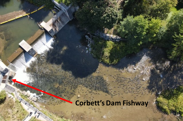
The main obstacle is Corbett’s Dam and Fishway, located about 3 kilometers upstream from Lake Ontario. While the fishway allows fish to pass, it slows down migrating fish while they learn to navigate it. This is especially true during large runs like the fall Chinook salmon migration, when hundreds of fish gather below the dam.
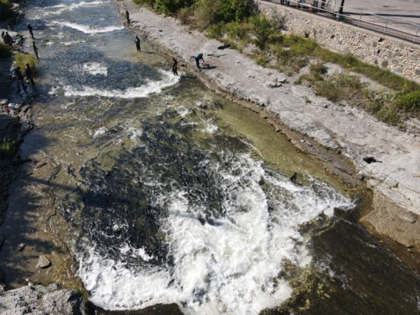
Downstream of the dam, channel modifications for flood control make fish migration more complicated. Fish accumulate in engineered step pools separated by shallow limestone stretches.
During the peak Chinook salmon migration, the dam and step pools cause thousands of fish to build up in the lower river. The fish that are below the existing sanctuary are vulnerable to angling.
The existing fish sanctuary (from the 401 to south side of Jocelyn Street) was put in place to protect migrating fish held up by the dam. This sanctuary is not large enough to protect the Chinook salmon in the fall when they are at peak abundance.
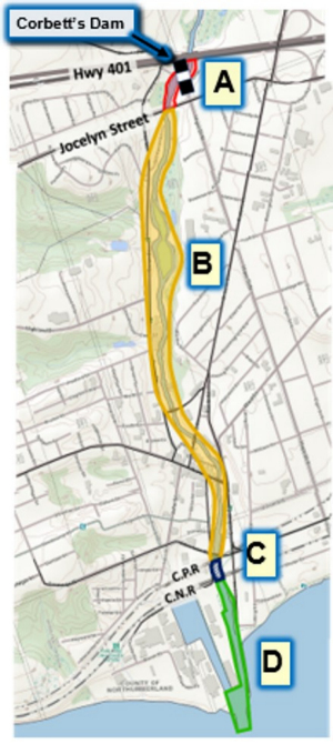
Map 1. Existing fishing areas and rules
Existing rules for the lower Ganaraska River
| Area description | Existing rules (seasons and sanctuaries) |
|---|---|
| Area A – from Highway 401 to the south side of Jocelyn Street | Closed all year – fish sanctuary |
| Area B – from south side of Jocelyn Street to south side of CPR bridge | Open from the fourth Saturday in April to September 30 |
| Area C – downstream of the south side of CPR bridge | Open – extended fall season Open from the fourth Saturday in April to December 31 |
| Area D – south side of CNR right-of-way to Lake Ontario | Open all year |
Proposed changes
New fish sanctuary
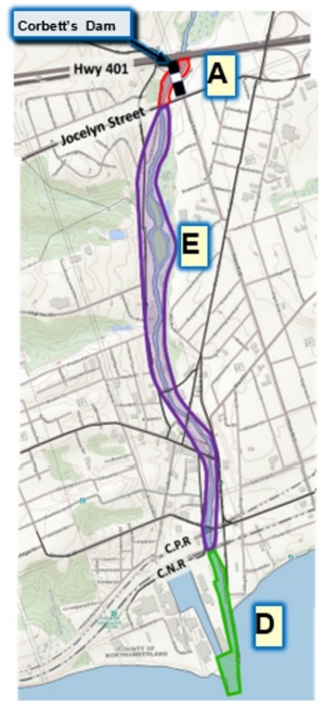
We are proposing a new fish sanctuary on the Ganaraska River between the Jocelyn Street bridge and the CNR bridge, from September 1 to October 14 (Map 2, Area E).
The fish sanctuary would:
- prohibit fishing in this area from September 1 to October 14, providing a 44-day sanctuary to protect Chinook salmon
- provide protection for about 90% of migrating Chinook salmon, based on our data from 2017 to 2023
This proposed sanctuary is in addition to the existing year-round sanctuary that is currently in place from Highway 401 to the Jocelyn Street bridge (Maps 1 and 2, Area A).
New extended fall season
We are proposing an ‘extended fall season’ from October 15 to December 31 for the waters between the Jocelyn Street bridge and the CNR bridge (Map 2, Area E).
This proposal would:
- increases the number of days open to angling to 78 days
- increase the amount of fishable water available, more in line with other Lake Ontario tributaries such as Duffins Creek, Oshawa Creek, Bowmanville Creek and Wilmot Creek
- provide more opportunities for anglers targeting fall running rainbow trout
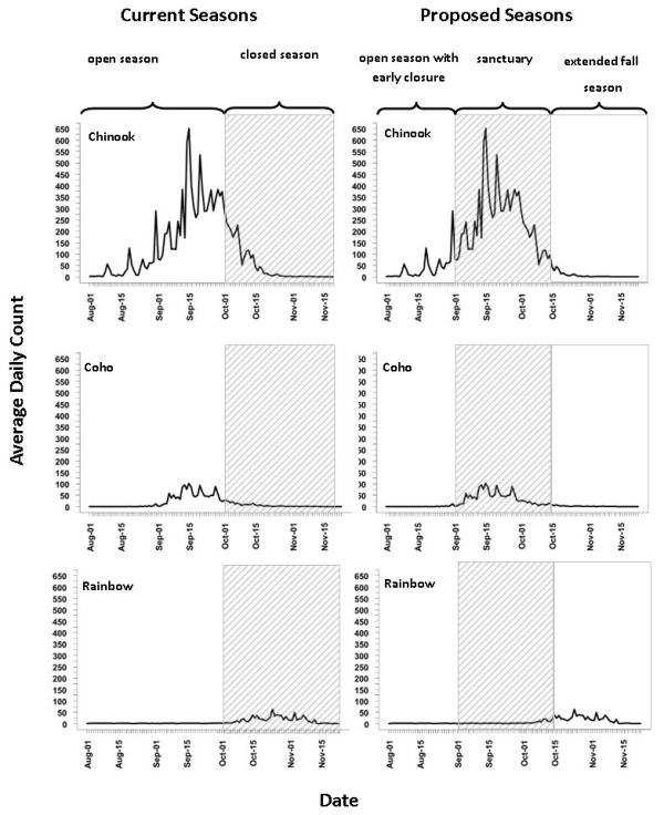
Densities of fall-running rainbow trout are much lower than the densities of Chinook salmon (see Figure 1), so we do not anticipate accumulations of confined fish below the sanctuary.
Map 2. Proposed fishing areas and rules
Proposed rules for the lower Ganaraska River
| Area description | Proposed rules (seasons and sanctuaries) |
|---|---|
| Area A – from Highway 401 to the south side of Jocelyn Street | Closed – all year (fish sanctuary) |
| Area E – from south side of Jocelyn Street to south side of CNR right-of-way | Open – fourth Saturday in April to August 31 Closed – September 1 to October 14 (fish sanctuary) Open – October 15 to December 31 (extended fall season) |
| Area D – South side of CNR right-of-way to Lake Ontario | Open all year |
Why we selected these dates
The dates we selected for the proposed seasons are based on fish passage information collected at Corbett’s Dam using new fish counter technology, known as Riverwatcher.
Riverwatcher uses infra-red scanners and high-resolution cameras to count daily upstream and downstream movements of fish. The number of fish passing through the fishway in a day correlates with the number of fish in the lower river.
First installed in 2017, we use Riverwatcher to monitor multiple years of fish passage data. This includes years with both late and early run timing, allowing us to better estimate expected densities in the lower river (Figure 1).
Figure 1. The graphs show how the current and proposed season scenarios line up with the migration timing of:
- Chinook salmon
- coho salmon
- rainbow trout
How to participate
This survey closed on August 22, 2024 — midnight.
For more information, please contact us at FishPTBO@ontario.ca.
