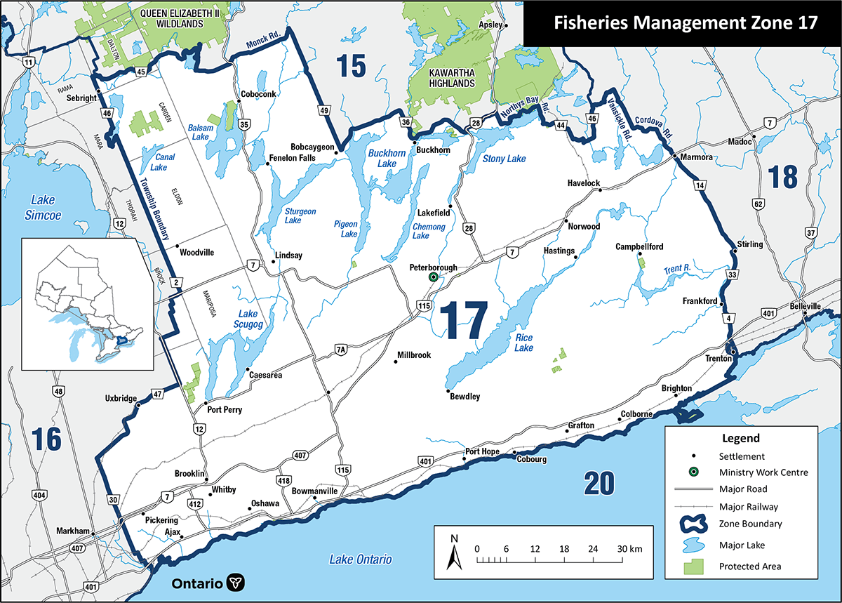
Fisheries Management Zone 17 (FMZ 17)
Information about fishing and how fish resources are managed in Fisheries Management Zone 17 (Peterborough and the Kawarthas).
News and updates
Changes to recreational fishing rules in FMZ 17
From July 24 to August 22, 2024, we consulted on proposed changes to recreational fishing rules on the lower Ganaraska River in the Town of Port Hope.
Summary of changes
The following changes take effect Sunday, September 1, 2024.
New fish sanctuary (all species):
- Ganaraska River: from the south side of the Jocelyn Street Bridge (43°58′1.77″N., 78°17′43.77″W.) to the southerly limit of the C.N.R. right-of-way (43°56′48.51″N., 78°17′31.93″W.)
- no fishing from September 1 to October 14
New expanded extended fall season (Atlantic salmon, brown trout, Pacific salmon and rainbow trout):
- Ganaraska River: from the south side of the Jocelyn Street Bridge (43°58′1.77″N., 78°17′43.77″W.) to the southerly limit of the C.N.R. right-of-way (43°56′48.51″N., 78°17′31.93″W.)
- open from:
- the fourth Saturday in April to August 31
- October 15 to December 31
These changes will:
- help protect vulnerable migrating Chinook salmon during peak migration
- provide additional angling opportunities for Atlantic salmon, brown trout, Pacific salmon and rainbow trout in the fall season
Read the Ontario Fishing Regulations Summary to learn more about the rules for fishing in the Ganaraska River.
Lake Scugog walleye fishery closed
This change is reflected in the 2016 Ontario Fishing Regulations Summary.
The comments received through the public consultation process helped the ministry determine the regulation change for the Lake Scugog walleye fishery.
Fishing rules
You can:
- find specific rules for fishing in FMZ 17
- use the Fish on-Line mapping tool
- find a complete set of fishing rules in the Ontario Fishing Regulations Summary
About this zone
FMZ 17, the smallest FMZ, is located in southern Ontario. This zone has:
- important recreational and tourism-based fisheries
- recreational fisheries for walleye, bass, panfish
- the highest use because of its superb fishing and urban location
FMZ 17 is one of 20 fisheries management zones in the province.
Location
FMZ 17:
- includes the Kawartha Lakes, Trent and Crowe River watersheds, and the eastern rivers and streams of the Oak Ridges Moraine
- is bordered by Lake Ontario to the south (FMZ 20)
Legal boundary map and detail maps
Legal boundary map for FMZ 17 and detail maps 1 - 16 (PDF)
Monitoring reports and management plans
Zone advisory council
The FMZ 17 council provides advice during the development of fisheries objectives and strategies. Council members represent a broad range of views including:
- angling groups
- scientists and researchers
- conservation groups
- interested community members
The advisory council participates in fisheries management by:
- sharing ideas and expertise with the ministry
- helping to develop and implement management strategies
- communicating with the local and angling community
For more information about the Fisheries Management Zone 17 advisory council, please email the council.
