Rabies cases
Annual summaries and maps of confirmed cases of rabies in Ontario for the past 5 years.
Recent rabies cases
Active surveillance for wildlife rabies in Ontario, including current cases, can be found on our rabies outbreak and control operations page. Our surveillance map is updated monthly.
Rabies case data summaries for previous years are available on the open data catalogue. The maps and tables identify areas with positive rabies cases, using information reported by the Canadian Food Inspection Agency.
Rabies cases in 2025
In 2025, there were 121 cases of rabies confirmed in Ontario comprised of 116 bat variant cases and 5 Arctic fox variant cases.
Table and map: positive rabies cases by region (with data from the Canadian Food Inspection Agency)
| Municipality | Species | Bat variant | Arctic fox variant |
|---|---|---|---|
| City of Barrie | Big brown bat | 2 | 0 |
| City of Belleville | Big brown bat | 1 | 0 |
| City of Brantford | Big brown bat | 3 | 0 |
| City of Brockville | Big brown bat | 2 | 0 |
| City of Cornwall | Big brown bat | 1 | 0 |
| City of Cornwall | Silver-haired bat | 1 | 0 |
| City of Hamilton | Big brown bat | 10 | 0 |
| City of Kawartha Lakes | Big brown bat | 3 | 0 |
| City of Kingston | Big brown bat | 1 | 0 |
| City of London | Big species | 1 | 0 |
| City of London | Big brown bat | 4 | 0 |
| City of North Bay | Big brown bat | 1 | 0 |
| City of Orillia | Big brown bat | 1 | 0 |
| City of Ottawa | Big brown bat | 7 | 0 |
| City of Pembroke | Big brown bat | 1 | 0 |
| City of Peterborough | Big brown bat | 1 | 0 |
| City of Toronto | Big brown bat | 3 | 0 |
| City of Toronto | Silver-haired bat | 1 | 0 |
| City of Windsor | Big brown bat | 1 | 0 |
| County of Brant | Big brown bat | 2 | 0 |
| County of Bruce | Big brown bat | 2 | 0 |
| County of Dufferin | Big brown bat | 2 | 0 |
| County of Elgin | Big brown bat | 2 | 0 |
| County of Frontenac | Big brown bat | 1 | 0 |
| County of Grey | Silver-haired bat | 1 | 0 |
| County of Haliburton | Big brown bat | 1 | 0 |
| County of Haliburton | Little brown bat | 1 | 0 |
| County of Hastings | Big brown bat | 1 | 0 |
| County of Huron | Big brown bat | 4 | 0 |
| County of Lambton | Big brown bat | 2 | 0 |
| County of Lennox and Addington | Big brown bat | 1 | 0 |
| County of Middlesex | Big brown bat | 2 | 0 |
| County of Oxford | Big brown bat | 3 | 0 |
| County of Perth | Big brown bat | 1 | 0 |
| County of Peterborough | Big brown bat | 1 | 0 |
| County of Simcoe | Big brown bat | 1 | 0 |
| County of Simcoe | Little brown bat | 1 | 0 |
| County of Wellington | Big brown bat | 1 | 0 |
| Haldimand County | Big brown bat | 1 | 0 |
| Municipality of Callander | Big brown bat | 1 | 0 |
| Municipality of Chatham-Kent | Big brown bat | 1 | 0 |
| Municipality of Chatham-Kent (Walpole Island First Nation) | Big brown bat | 1 | 0 |
| Municipality of Temagami (Bear Island, Teme Augama Anishinabek) | Little brown bat | 1 | 0 |
| Rainy River District | Bat species | 1 | 0 |
| Regional Municipality of Durham | Big brown bat | 4 | 0 |
| Regional Municipality of Halton | Big brown bat | 3 | 0 |
| Regional Municipality of Niagara | Big brown bat | 8 | 0 |
| Regional Municipality of Peel | Big brown bat | 3 | 0 |
| Regional Municipality of Waterloo | Big brown bat | 2 | 0 |
| Regional Municipality of York | Big brown bat | 11 | 0 |
| Town of Gananoque | Big brown bat | 1 | 0 |
| Town of Prescott | Big brown bat | 1 | 0 |
| Township of Assiginack | Little brown bat | 1 | 0 |
| United Counties of Prescott and Russell | Red fox | 1 | 0 |
| Far north region | Red fox | 0 | 5 |
| Total | N/A | 116 | 5 |
Map of 2025 reported rabies cases
Arctic fox variant rabies is widespread and regularly occurring, across Arctic and sub-Arctic habitats in Canada. The rabies virus is known to cycle in fox populations in the North, so the risk in wildlife, especially foxes, is always present, but can also naturally vary from year to year.
Cases detected in 2025 were all found within the endemic range (shown in red).
There were no cases of raccoon variant rabies detected in Ontario for the second year in a row.
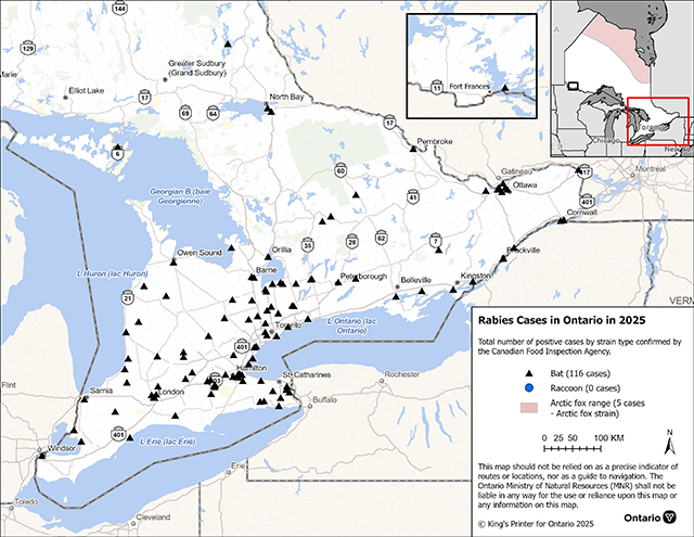
Enlarge rabies positives map — 2025.
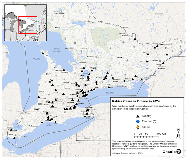
Rabies cases in 2024
In 2024, there were 91 cases of rabies confirmed in Ontario.
Table and map: positive rabies cases by region (with data from the Canadian Food Inspection Agency)
| Municipality | Species | Bat strain |
|---|---|---|
| City of Belleville | Big brown bat | 1 |
| City of Brantford | Big brown bat | 2 |
| City of Hamilton | Big brown bat | 5 |
| City of Kawartha Lakes | Silver-haired bat | 1 |
| City of Kingston | Big brown bat | 1 |
| City of London | Big brown bat | 2 |
| City of Ottawa | Big brown bat | 2 |
| City of Peterborough | Big brown bat | 2 |
| City of Peterborough | Silver-haired bat | 1 |
| City of St. Thomas | Big brown bat | 1 |
| City of Stratford | Big brown bat | 1 |
| City of Toronto | Big brown bat | 12 |
| City of Toronto | Hoary bat | 1 |
| City of Toronto | Silver-haired bat | 1 |
| City of Windsor | Big brown bat | 1 |
| County of Brant | Big brown bat | 1 |
| County of Brant | Human | 1 |
| County of Bruce | Big brown bat | 3 |
| County of Bruce | Little brown bat | 1 |
| County of Elgin | Big brown bat | 4 |
| County of Elgin | Hoary bat | 1 |
| County of Essex | Big brown bat | 1 |
| County of Grey | Big brown bat | 1 |
| County of Huron | Big brown bat | 1 |
| County of Lanark | Big brown bat | 2 |
| County of Lennox and Addington | Big brown bat | 1 |
| County of Lennox and Addington | Silver-haired bat | 1 |
| County of Northumberland | Big brown bat | 2 |
| County of Oxford | Big brown bat | 1 |
| County of Perth | Big brown bat | 2 |
| County of Peterborough | Big brown bat | 1 |
| County of Peterborough | Silver-haired bat | 1 |
| County of Renfrew | Big brown bat | 1 |
| County of Simcoe | Big brown bat | 4 |
| County of Simcoe | Little brown bat | 1 |
| County of Wellington | Big brown bat | 2 |
| Regional Municipality of Durham | Big brown bat | 5 |
| Regional Municipality of Durham | Little brown bat | 1 |
| Regional Municipality of Halton | Big brown bat | 2 |
| Regional Municipality of Halton | Little brown bat | 1 |
| Regional Municipality of Niagara | Big brown bat | 5 |
| Regional Municipality of Peel | Big brown bat | 2 |
| Regional Municipality of York | Big brown bat | 5 |
| Regional Municipality of York | Silver-haired bat | 1 |
| United Counties of Leeds and Grenville | Big brown bat | 1 |
| United Counties of Stormont, Dundas and Glengarry | Big brown bat | 1 |
| Total | N/A | 91 |
Map of 2024 reported rabies cases

Enlarge rabies positives map — 2024
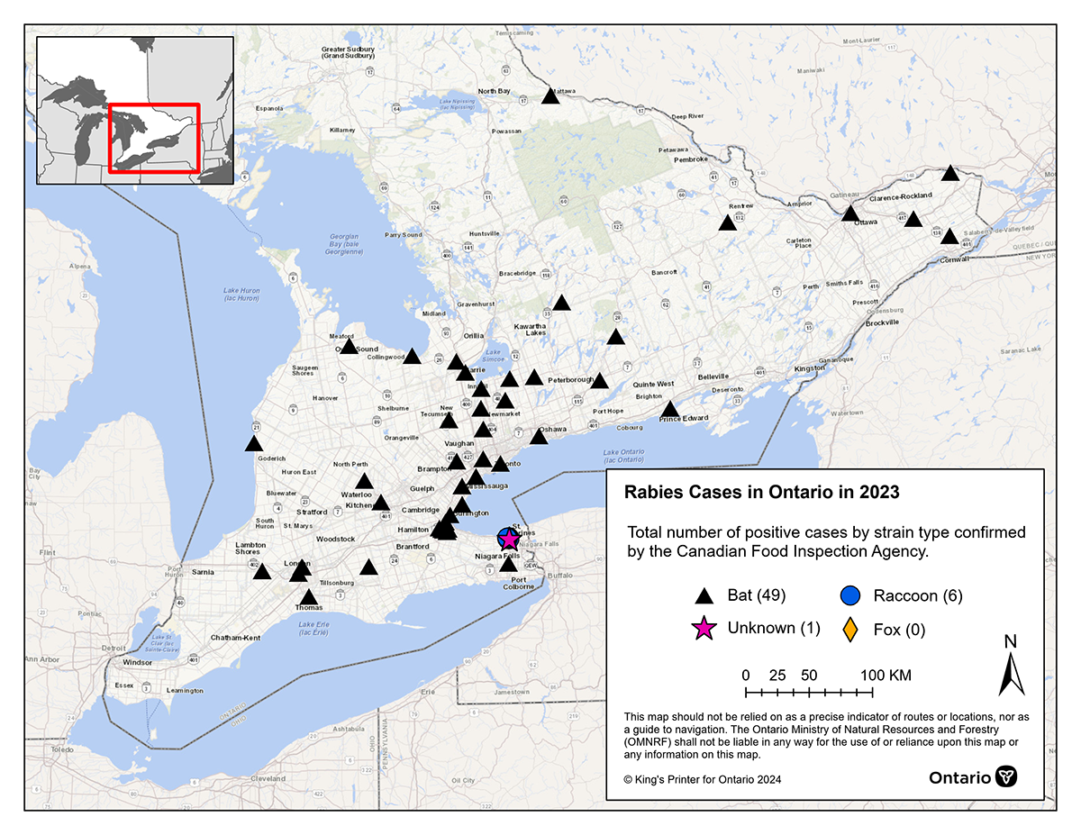
Rabies cases in 2023
In 2023, there were 56 cases of rabies confirmed in Ontario.
Table and map: positive rabies cases by region (with data from the Canadian Food Inspection Agency)
| Municipality | Species | Bat strain | Raccoon strain |
|---|---|---|---|
| City of Barrie | Big brown bat | 1 | 0 |
| City of Hamilton | Big brown bat | 8 | 0 |
| City of Kawartha Lakes | Big brown bat | 1 | 0 |
| City of London | Big brown bat | 3 | 0 |
| City of Ottawa | Hoary bat | 1 | 0 |
| City of Peterborough | Big brown bat | 1 | 0 |
| City of Quinte West | Big brown bat | 1 | 0 |
| City of St.Thomas | Big brown bat | 1 | 0 |
| City of Toronto | Big brown bat | 4 | 0 |
| County of Grey | Little brown bat | 1 | 0 |
| County of Haliburton | Big brown bat | 1 | 0 |
| County of Huron | Big brown bat | 1 | 0 |
| County of Middlesex | Big brown bat | 1 | 0 |
| County of Oxford | Big brown bat | 1 | 0 |
| County of Peterborough | Big brown bat | 1 | 0 |
| County of Renfrew | Big brown bat | 1 | 0 |
| County of Simcoe | Big brown bat | 2 | 0 |
| County of Simcoe | Little brown bat | 1 | 0 |
| County of Wellington | Big brown bat | 1 | 0 |
| District of Nipissing | Big brown bat | 1 | 0 |
| Regional Municipality of Durham | Big brown bat | 2 | 0 |
| Regional Municipality of Halton | Big brown bat | 3 | 0 |
| Regional Municipality of Niagara | Big brown bat | 1 | 0 |
| Regional Municipality of Niagara | Cat | 1 | 0 |
| Regional Municipality of Niagara | Skunk | 0 | 6 |
| Regional Municipality of Peel | Big brown bat | 2 | 0 |
| Regional Municipality of Waterloo | Big brown bat | 1 | 0 |
| Regional Municipality of York | Big brown bat | 3 | 0 |
| Regional Municipality of York | Little brown bat | 1 | 0 |
| United Counties of Prescott and Russell | Big brown bat | 2 | 0 |
| United Counties of Stormont, Dundas and Glengarry | Big brown bat | 1 | 0 |
| Total | NA | 50 | 6 |
Map of 2023 reported rabies cases

Enlarge rabies positives map — 2023
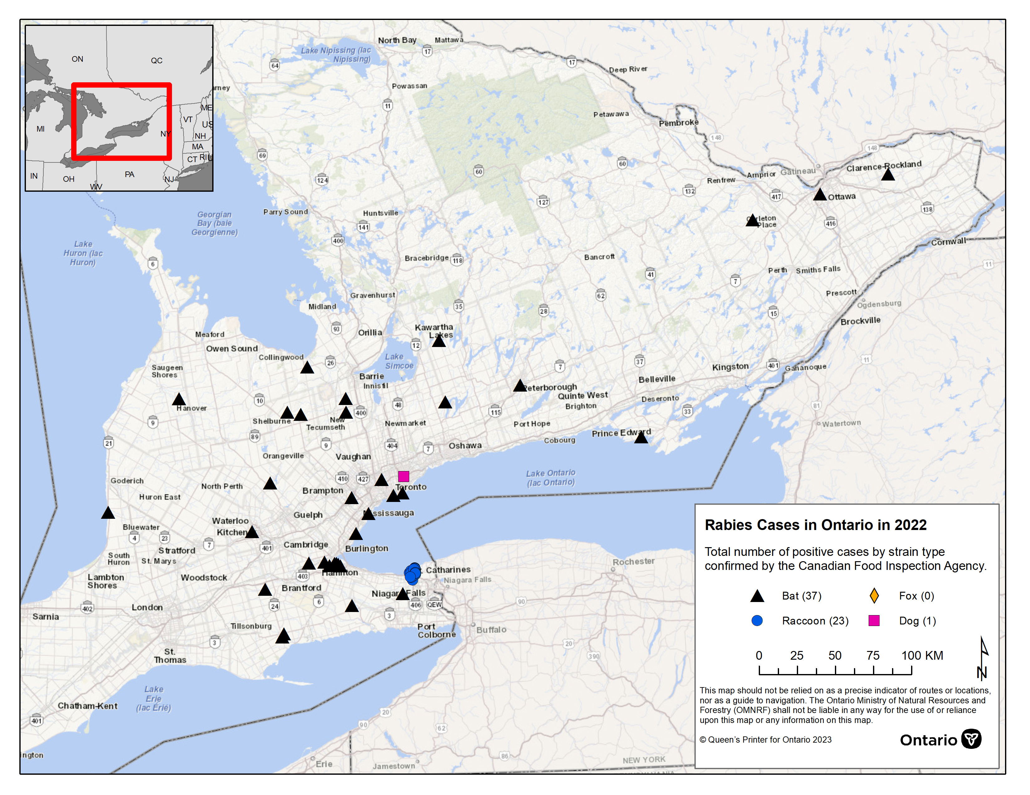
Rabies cases in 2022
In 2022, there were 61 cases of rabies confirmed in Ontario.
Table and map: positive rabies cases by region (with data from the Canadian Food Inspection Agency)
| Municipality | Species | Bat strain | Dog strain | Raccoon strain |
|---|---|---|---|---|
| City of Hamilton | Big brown bat | 6 | 0 | 0 |
| City of Hamilton | Skunk | 1 | 0 | 0 |
| City of Kawartha Lakes | Big brown bat | 2 | 0 | 0 |
| City of Ottawa | Little brown bat | 1 | 0 | 0 |
| City of Peterborough | Big brown bat | 1 | 0 | 0 |
| City of Toronto | Big brown bat | 4 | 0 | 0 |
| City of Toronto | Dog | 0 | 1 | 0 |
| City of Toronto | Silver-haired bat | 1 | 0 | 0 |
| County of Brant | Big brown bat | 1 | 0 | 0 |
| County of Bruce | Big brown bat | 2 | 0 | 0 |
| County of Dufferin | Big brown bat | 1 | 0 | 0 |
| County of Dufferin | Silver-haired bat | 1 | 0 | 0 |
| County of Huron | Big brown bat | 1 | 0 | 0 |
| County of Lanark | Big brown bat | 1 | 0 | 0 |
| County of Prince Edward | Big brown bat | 1 | 0 | 0 |
| County of Simcoe | Big brown bat | 3 | 0 | 0 |
| County of Wellington | Big brown bat | 1 | 0 | 0 |
| Haldimand County | Big brown bat | 1 | 0 | 0 |
| Norfolk County | Big brown bat | 2 | 0 | 0 |
| Regional Municipality of Halton | Big brown bat | 1 | 0 | 0 |
| Regional Municipality of Niagara | Big brown bat | 1 | 0 | 0 |
| Regional Municipality of Niagara | Raccoon | 0 | 0 | 5 |
| Regional Municipality of Niagara | Skunk | 0 | 0 | 18 |
| Regional Municipality of Peel | Big brown bat | 2 | 0 | 0 |
| Regional Municipality of Waterloo | Skunk | 1 | 0 | 0 |
| United Counties of Prescott and Russell | Big brown bat | 1 | 0 | 0 |
| Total | NA | 37 | 1 | 23 |
Map of 2022 reported rabies cases

Enlarge rabies positives map — 2022
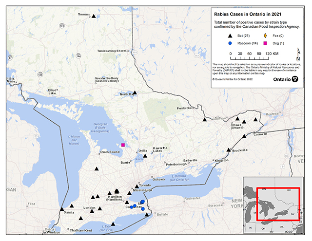
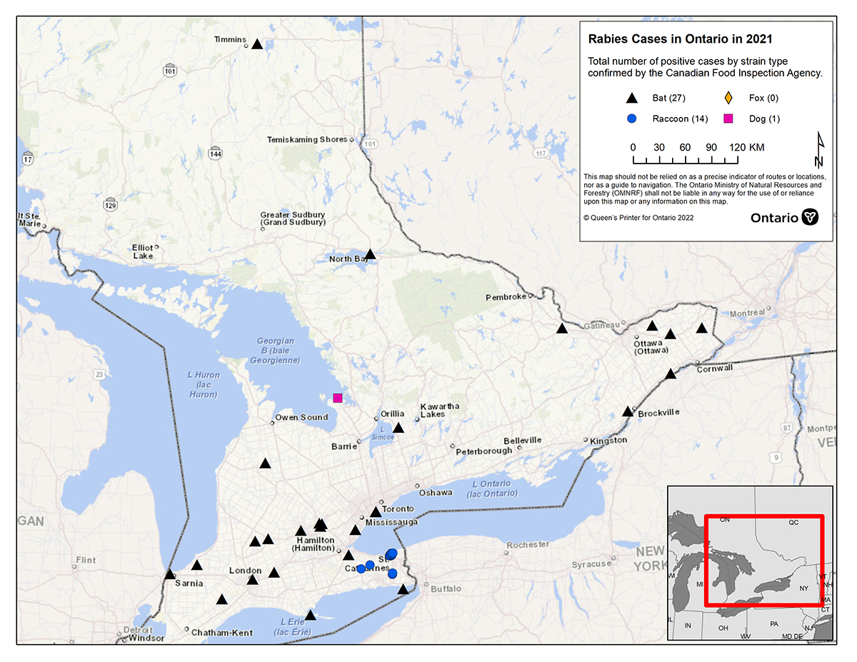
Rabies cases in 2021
In 2021, there were 42 cases of rabies confirmed in Ontario.
Table and map: positive rabies cases by region (with data from the Canadian Food Inspection Agency)
| Municipality | Species | Bat strain | Dog strain | Raccoon strain |
|---|---|---|---|---|
| City of Guelph | Big brown bat | 2 | 0 | 0 |
| City of Hamilton | Big brown bat | 1 | 0 | 0 |
| City of London | Big brown bat | 1 | 0 | 0 |
| City of Ottawa | Big brown bat | 1 | 0 | 0 |
| City of Stratford | Big brown bat | 1 | 0 | 0 |
| City of Toronto | Big brown bat | 1 | 0 | 0 |
| City of Toronto | Little brown bat | 1 | 0 | 0 |
| County of Grey | Big brown bat | 1 | 0 | 0 |
| County of Lambton | Big brown bat | 2 | 0 | 0 |
| County of Middlesex | Big brown bat | 1 | 0 | 0 |
| County of Oxford | Big brown bat | 1 | 0 | 0 |
| County of Perth | Big brown bat | 1 | 0 | 0 |
| County of Renfrew | Big brown bat | 1 | 0 | 0 |
| County of Simcoe | Dog | 1 | 1 | 0 |
| County of Wellington | Little brown bat | 1 | 0 | 0 |
| District of Cochrane | Little brown bat | 1 | 0 | 0 |
| District of Nipissing | Big brown bat | 1 | 0 | 0 |
| Norfolk County | Big brown bat | 1 | 0 | 0 |
| Regional Municipality of Durham | Big brown bat | 1 | 0 | 0 |
| Regional Municipality of Halton | Big brown bat | 1 | 0 | 0 |
| Regional Municipality of Niagara | Big brown bat | 1 | 0 | 0 |
| Regional Municipality of Niagara | Raccoon | 0 | 0 | 2 |
| Regional Municipality of Niagara | Skunk | 0 | 0 | 12 |
| Regional Municipality of Waterloo | Big brown bat | 1 | 0 | 0 |
| United Counties of Leeds and Grenville | Big brown bat | 1 | 0 | 0 |
| United Counties of Prescott and Russell | Big brown bat | 1 | 0 | 0 |
| United Counties of Stormont, Dundas and Glengarry | Big brown bat | 2 | 0 | 0 |
| Total | NA | 27 | 1 | 14 |
Map of 2021 reported rabies cases
Footnotes
- footnote[1] Back to paragraph human with bat strain rabies
- footnote[2] Back to paragraph variant typing not done, classified as bat strain.
- footnote[3] Back to paragraph imported dog with Iranian dog strains.