Recovery strategy for the Massasauga
Read the recovery strategy for the Carolinian and the Great Lakes – St. Lawrence populations of the Massasauga (Sistrurus catenatus), a species of snake at risk in Ontario.
Cover photo by Joe Crowley
About the Ontario recovery strategy series
This series presents the collection of recovery strategies that are prepared or adopted as advice to the Province of Ontario on the recommended approach to recover species at risk. The Province ensures the preparation of recovery strategies to meet its commitments to recover species at risk under the Endangered Species Act, 2007 (ESA) and the Accord for the Protection of Species at Risk in Canada.
What is recovery?
Recovery of species at risk is the process by which the decline of an endangered, threatened, or extirpated species is arrested or reversed, and threats are removed or reduced to improve the likelihood of a species' persistence in the wild.
What is a recovery strategy?
Under the ESA a recovery strategy provides the best available scientific knowledge on what is required to achieve recovery of a species. A recovery strategy outlines the habitat needs and the threats to the survival and recovery of the species. It also makes recommendations on the objectives for protection and recovery, the approaches to achieve those objectives, and the area that should be considered in the development of a habitat regulation. Sections 11 to 15 of the ESA outline the required content and timelines for developing recovery strategies published in this series.
Recovery strategies are required to be prepared for endangered and threatened species within one or two years respectively of the species being added to the Species at Risk in Ontario list. Recovery strategies are required to be prepared for extirpated species only if reintroduction is considered feasible.
What’s next?
Nine months after the completion of a recovery strategy a government response statement will be published which summarizes the actions that the Government of Ontario intends to take in response to the strategy. The implementation of recovery strategies depends on the continued cooperation and actions of government agencies, individuals, communities, land users, and conservationists.
For more information
To learn more about species at risk recovery in Ontario, please visit the Ministry of Natural Resources and Forestry Species at Risk webpage.
Recommended citation
Ontario Ministry of Natural Resources and Forestry. 2016. Recovery Strategy for the Massasauga (Sistrurus catenatus) – Carolinian and Great Lakes – St. Lawrence populations in Ontario. Ontario Recovery Strategy Series. Prepared by the Ontario Ministry of Natural Resources and Forestry, Peterborough, Ontario. v + 9 pp. + Appendix ix + 37 pp. Adoption of the Recovery Strategy for the Massasauga (Sistrurus catenatus) in Canada (Parks Canada Agency 2015).
© Queen’s Printer for Ontario, 2016
ISBN 978-1-4606-7675-2 (HTML)
ISBN 978-1-4606-7684-4 (PDF)
Content (excluding the cover illustration and images in the appended federal recovery strategy) may be used without permission, with appropriate credit to the source.
Cette publication hautement spécialisée « Recovery strategies prepared under the Endangered Species Act, 2007 », n'est disponible qu'en anglais en vertu du Règlement 411/97 qui en exempte l'application de la Loi sur les services en français. Pour obtenir de l'aide en français, veuillez communiquer avec recovery.planning@ontario.ca.
Acknowledgments
We thank Matthew Allender of the University of Illinois, Doug Campbell of the Canadian Wildlife Health Cooperative, Mike Colley of Laurentian University, Jonathan Choquette of SCC Ecological and Joe Crowley of the Ontario Ministry of Natural Resources and Forestry (OMNRF) for providing information that assisted in the development of this recovery strategy.
Declaration
The recovery strategy for the Carolinian and Great Lakes – St. Lawrence populations of the Massasauga was developed in accordance with the requirements of the Endangered Species Act, 2007 (ESA). This recovery strategy has been prepared as advice to the Government of Ontario, other responsible jurisdictions and the many different constituencies that may be involved in recovering the species.
The recovery strategy does not necessarily represent the views of all of the individuals who provided advice or contributed to its preparation, or the official positions of the organizations with which the individuals are associated.
The goals, objectives and recovery approaches identified in the strategy are based on the best available knowledge and are subject to revision as new information becomes available. Implementation of this strategy is subject to appropriations, priorities and budgetary constraints of the participating jurisdictions and organizations.
Success in the recovery of this species depends on the commitment and cooperation of many different constituencies that will be involved in implementing the directions set out in this strategy.
Responsible jurisdictions
Ontario Ministry of Natural Resources and Forestry
Environment and Climate Change Canada – Canadian Wildlife Service, Ontario
Parks Canada Agency
Executive summary
Executive summary of Ontario’s recovery strategy
The Endangered Species Act, 2007 (ESA) requires the Minister of Natural Resources and Forestry to ensure recovery strategies are prepared for all species listed as endangered or threatened on the Species at Risk in Ontario (SARO) List. Under the ESA, a recovery strategy may incorporate all or part of an existing plan that relates to the species.
The Massasauga (Sistrurus catenatus) is listed as two distinct populations on the SARO List: the Carolinian population is listed as endangered and the Great Lakes – St. Lawrence population is listed as threatened. The Massasauga (Sistrurus catenatus) is listed as threatened under the federal Species at Risk Act (SARA). The Parks Canada Agency prepared the Recovery Strategy for the Massasauga (Sistrurus catenatus) in Canada in 2015 to meet its requirements under the SARA. This recovery strategy is hereby adopted under the ESA. With the additions indicated below, the enclosed strategy meets all of the content requirements outlined in the ESA.
Based on the most recent COSEWIC assessment and status report, abundance of the Massasauga (Carolinian population) is estimated at 80 (±30) mature individuals. Extinction of the Ojibway subpopulation is considered imminent with current abundance estimated to be as low as 10 – 40 adults. Abundance of the Great Lakes – St. Lawrence population is roughly estimated to be 16,000 (9,100 – 22,200) mature individuals. Recent publications, with new information concerning the feasibility of the Ojibway subpopulation recovery, are also discussed in this adoption.
In addition to the threats outlined in the federal recovery strategy, Snake Fungal Disease (SFD) and climate change may impact the Massasauga in Ontario. Snake Fungal Disease has been recently documented in an Eastern Foxsnake in southwestern Ontario. Since SFD is still poorly understood and has the potential to cause widespread decline of snake populations, further research and monitoring is required to assess the spread of SFD in Ontario. A recent assessment of the effects of climate change on the Massasauga found that the species is likely to decline throughout its range as a result of climate change, although declines are expected to be less severe at the northern extent of its range in Ontario.
The Critical Habitat section of the federal recovery strategy provides an identification of critical habitat (as defined under the SARA). Identification of critical habitat is not a component of a recovery strategy prepared under the ESA. However, it is recommended that the approach used to identify critical habitat in the federal recovery strategy, together with the General Habitat Description for Massasauga in Ontario and relevant research, be considered when developing a habitat regulation under the ESA.
Executive summary of Canada’s recovery strategy
The Massasauga (Sistrurus catenatus) is a stout-bodied, relatively small rattlesnake that feeds primarily on small mammals. It is assessed as Threatened by the Committee on the Status of Endangered Wildlife in Canada (COSEWIC) due to a historical population decline, continued habitat fragmentation and loss, and human persecution, and is listed as Threatened on Schedule 1 of the Species at Risk Act (SARA). Canada hosts 8-10% of the global distribution of this species. The eastern Georgian Bay and Bruce Peninsula Massasauga populations are believed to be the largest and most secure found anywhere across the species entire range.
Within Canada, the Massasauga is known to occur in four separate regional populations in Ontario: (1) eastern Georgian Bay (including Big Chute on the Trent-Severn Waterway); (2) Bruce Peninsula (including Manitoulin Island, Vidal Island, and Fitzwilliam Island); (3) Wainfleet Bog near Port Colborne; and (4) the Ojibway Prairie complex in Windsor and the Town of LaSalle. These populations occupy a broad range of natural communities (e.g. forests, wetlands, grasslands, alvars) and are situated within a variety of landscapes, ranging from largely natural, forested landscapes, to predominantly agricultural, to predominantly urban.
Threats to the Massasauga are primarily related to human population growth in southern Ontario and associated influences on the natural environment, including habitat loss, fragmentation, and road mortality. Also persecution, the pet trade, forest management, and peat extraction, have all been detrimental to the survival of the species.
The long-term recovery goal for the Massasauga in Ontario is the persistence of the species throughout its current range, by preventing extirpation of the Ojibway population; securing viable populations in the Wainfleet, Bruce Peninsula, and eastern Georgian Bay regional populations; and retaining a sufficient distribution and degree of habitat connectivity among local populations to maintain the current extent and area of occupancy throughout the Bruce Peninsula and eastern Georgian Bay regional populations. Accordingly, specific population and distribution objectives are set for each of the four regional populations. Critical habitat targeted to meet those objectives, is identified in this recovery strategy, for all four regional populations, based on the best available information. Activities likely to result in the destruction of critical habitat have been identified, while a schedule of studies lists the additional steps required to complete critical habitat identification.
Recovery approaches to achieve the population and distribution objectives for the Massasauga include habitat management and protection, habitat restoration, communication and outreach, research, and population management, and these are presented in detail in Section 6.2, Strategic Direction for Recovery.
One or more action plans will be completed by December 2020.
Adoption of federal recovery strategy
The Endangered Species Act, 2007 (ESA) requires the Minister of Natural Resources and Forestry to ensure recovery strategies are prepared for all species listed as endangered or threatened on the Species at Risk in Ontario (SARO) List. Under the ESA, a recovery strategy may incorporate all or part of an existing plan that relates to the species.
The Massasauga (Sistrurus catenatus) is listed as two distinct populations on the SARO List: the Carolinian population is listed as endangered and the Great Lakes – St. Lawrence population is listed as threatened. The Massasauga (Sistrurus catenatus) is listed as threatened under the federal Species at Risk Act (SARA). The Parks Canada Agency prepared the Recovery Strategy for the Massasauga (Sistrurus catenatus) in Canada in 2015 to meet its requirements under the SARA. This recovery strategy is hereby adopted under the ESA. With the additions indicated below, the enclosed strategy meets all of the content requirements outlined in the ESA.
Species assessment and classification
Table 1. Species assessment and classification of the Massasauga (Carolinian population) and Massasauga (Great Lakes – St. Lawrence population) (Sistrurus catenatus). The glossary provides definitions for the abbreviations within, and for other technical terms in this document.
| Assessment | Status |
|---|---|
| SARO list classification | Massasauga (Carolinian population) – Endangered Massasauga (Great Lakes – St. Lawrence population) – Threatened |
| SARO list history | Massasauga (Carolinian population) – Endangered (2014) Massasauga (Great Lakes – St. Lawrence population) – Threatened (2014) Massasauga – Threatened (2008), Threatened – Not Regulated (2004) |
| COSEWIC assessment history | Massasauga (Carolinian population) – Endangered (2012) Massasauga (Great Lakes – St. Lawrence population) – Threatened (2012) Massasauga – Threatened (2002, 1991) |
| SARA schedule 1 | Massasauga: Threatened (2005) |
| Conservation status rankings | Massasauga (Carolinian population) GRANK: NR NRANK: NR SRANK: S1 Massasauga (Great Lakes – St. Lawrence population) GRANK: NR NRANK: NR SRANK: S3 Massasauga GRANK: G3G4 NRANK: N3 SRANK: NR |
COSEWIC (2012) recognizes two separate populations for the Massasauga (Sistrurus catenatus) in Ontario: the Carolinian and Great Lakes – St Lawrence populations. The populations are considered discrete and significant based on: genetic distinctiveness, eco-geographic regions, range disjunction, and ecological setting. They are currently separated by approximately 200 km of intensively modified landscape. Analysis of mitochondrial DNA showed a genetic clustering of Great Lakes – St. Lawrence subpopulations (Parry Sound and Bruce County) and a significant divergence between those populations and one of the Carolinian subpopulations (Ojibway Prairie) (COSEWIC 2012).
Both populations occur in distinct ecological settings that are likely to lead to local adaptations (COSEWIC 2012). The Carolinian population persists in tallgrass prairie-oak-savannah (Ojibway Prairie) and a peat land-swamp / forest-bog complex (Wainfleet Bog). The Great Lakes – St. Lawrence population occurs in a landscape where alvar and rock barren habitats are abundant and are used extensively by Massasaugas, giving rise to different patterns of habitat use compared to other parts of their North American range. Local behavioural adaptations in this landscape include long-distance dispersal to and from these sites.
Distribution, abundance and population trends
Based on the most recent COSEWIC assessment and status report, abundance of the Massasauga (Carolinian population) is estimated at 80 (±30) mature individuals (COSEWIC 2012). Extinction of the Ojibway subpopulation is considered imminent with current abundance estimated to be as low as 10 – 40 adults (COSEWIC 2012). Abundance of the Great Lakes – St. Lawrence population is roughly estimated to be 16,000 (9,100 – 22,200) mature individuals (COSEWIC 2012).
Additional information pertaining to the feasibility of recovery of the Ojibway Prairie subpopulation has become available since the publication of the federal recovery strategy. A report by Choquette et al. (2015) provides new information on the Ojibway Prairie subpopulation related to the potential for habitat improvement and connectivity, the potential for population augmentation, and local stakeholder commitment to recovery, among other things. Harvey et al. (2014) provides additional information pertinent to the feasibility of captive-breeding and release of Massasaugas for the purpose of population augmentation.
Habitat needs
Additional information on the habitat needs of the Massasauga, not referenced in the federal recovery strategy, can be found in the General Habitat Description for Massasauga in Ontario (OMNR 2013). This document provides a technical description of the habitat on which this species depends in the province.
Threats to survival and recovery
Snake Fungal Disease
Snake Fungal Disease (SFD), which is caused by the fungus Ophidiomyces ophiodiicola, is a significant emerging threat to North American snakes. This pathogen was first documented in 2006 in the eastern United States and has caused widespread mortality and population declines in a wide range of snake species throughout the eastern United States (Allender et al. 2015b). For example, SFD has been identified as one of the primary causes of a 50 percent decline in a Timber Rattlesnake population in New Hampshire over a two-year period (Clark et al. 2011). Pit vipers (snakes of the subfamily Crotalinae, which includes rattlesnakes) appear to be very susceptible to SFD (Allender et al. 2015b), and SFD has been documented in wild populations of Massasauga in Illinois and Michigan (Allender et al. 2011, Allender et al. 2015a, Tetzlaff et al. 2015). Skin lesions and subcutaneous swelling are the primary symptoms of SFD in Massasaugas, and mortality rate of infected Massasaugas can be as high as 95 percent (M.C. Allender, pers. comm. 2015). Snake Fungal Disease has been confirmed in an Eastern Foxsnake from the Point Pelee area of Ontario (D. Campbell, pers. comm. 2015), and there are several reports of symptoms that are consistent with those of SFD in other snake populations in Ontario (D. Campbell, pers. comm. 2015). Considering the susceptibility of Massasaugas to SFD and the extremely high mortality rates that have been documented in the U.S., this emerging threat has the potential to cause widespread decline of snake populations if it becomes established in Ontario. Additional research and monitoring is required to understand the ecology of SFD and assess distribution and prevalence in wild populations. A proactive approach to prevent the spread of SFD and to manage outbreaks is necessary (Allender et al. 2015a), consistent with recommended conservation responses to emerging wildlife diseases at their invasion front (Langwig et al. 2015).
Climate change
Massasauga populations are vulnerable to the effects of climate change, specifically increases in the frequency of severe weather events such as precipitation, flooding and drought (Pomara et al. 2014a). A recent assessment of the effects of climate change on the Massasauga found that this species is likely to continue to decline throughout its range as a result of climate change, although declines are expected to be less severe at the northern extent of its range in Ontario (Pomara et al. 2014b). In 2014 – 2015, over-winter mortality of Massasaugas in a portion of the eastern Georgian Bay population was unusually high; this mortality event is believed to have been caused by freeze-thaw cycles and flooding of hibernation sites in the late fall of 2014 (M. Colley pers. comm. 2015). Climate change also has the potential to exacerbate other stressors on Massasauga populations. For example, temperature affects the growth and prevalence of Snake Fungal Disease, and milder winters resulting from climate change may increase the vulnerability of snake populations to SFD (Allender et al. 2015b).
Approaches to recovery
New information under the section on Threats to Survival and Recovery above is not discussed in the federal recovery strategy. The federal recovery strategy does not include recovery actions to address these threats. Therefore, consideration should be given to relevant recovery actions that would help to address these new threats when developing recovery initiatives for this species in Ontario.
Area for consideration in developing a habitat regulation
Under the ESA, a recovery strategy must include a recommendation to the Minister of Natural Resources and Forestry on the area that should be considered in developing a habitat regulation. A habitat regulation is a legal instrument that prescribes an area that will be protected as the habitat of the species. The recommendation provided below will be one of many sources considered by the Minister, including information that may become newly available following completion of the recovery strategy, when developing the habitat regulation for this species.
The Critical Habitat section of the federal recovery strategy provides an identification of critical habitat (as defined under the SARA). Identification of critical habitat is not a component of a recovery strategy prepared under the ESA. However, it is recommended that the approach used to identify critical habitat in the federal recovery strategy, together with the General Habitat Description for Massasauga in Ontario (OMNR 2013) and relevant research, be considered when developing a habitat regulation under the ESA.
Glossary
- Committee on the Status of Endangered Wildlife in Canada (COSEWIC):
- The committee established under section 14 of the Species at Risk Act that is responsible for assessing and classifying species at risk in Canada.
- Committee on the Status of Species at Risk in Ontario (COSSARO):
- The committee established under section 3 of the Endangered Species Act, 2007 that is responsible for assessing and classifying species at risk in Ontario.
- Conservation status rank:
- A rank assigned to a species or ecological community that primarily conveys the degree of rarity of the species or community at the global (G), national (N) or subnational (S) level. These ranks, termed G-rank, N-rank and S-rank, are not legal designations. Ranks are determined by NatureServe and, in the case of Ontario’s S-rank, by Ontario’s Natural Heritage Information Centre. The conservation status of a species or ecosystem is designated by a number from 1 to 5, preceded by the letter G, N or S reflecting the appropriate geographic scale of the assessment. The numbers mean the following: 1 = critically imperilled
2 = imperilled
3 = vulnerable
4 = apparently secure
5 = secure
NR = not yet ranked - Endangered Species Act, 2007 (ESA):
- The provincial legislation that provides protection to species at risk in Ontario.
- Species at Risk Act (SARA):
- The federal legislation that provides protection to species at risk in Canada. This act establishes Schedule 1 as the legal list of wildlife species at risk. Schedules 2 and 3 contain lists of species that at the time the Act came into force needed to be reassessed. After species on Schedule 2 and 3 are reassessed and found to be at risk, they undergo the SARA listing process to be included in Schedule 1.
- Species at Risk in Ontario (SARO) List:
- The regulation made under section 7 of the Endangered Species Act, 2007 that provides the official status classification of species at risk in Ontario. This list was first published in 2004 as a policy and became a regulation in 2008.
References
Allender, M.C., M. Dreslik, S. Wylie, C. Phillips, D.B. Wylie, C. Maddox, M.A. Delaney, and M.J. Kinsel. 2011. Chrysosporium sp. infection in eastern massasauga rattlesnakes. Emerging Infectious Diseases 17:2383-2384.
Allender, M.C, E. Hileman, J. Moore, and S. Tetzlaff. 2015a. Ophidiomyces detection in the Eastern Massasauga in Michigan. Report prepared for the U.S. Fish and Wildlife Service, East Lansing Field Office. [website accessed September 2015].
Allender, M.C, D.B. Raudabaugh, F.H. Gleason, and A.N. Miller. 2015b. The natural history, ecology, and epidemiology of Ophidiomyces ophiodiicola and its potential impact on free-ranging snake populations. Fungal Ecology 17:187-196.
Allender, Matthew C., pers. comm. 2015. Personal communication to Joe Crowley (OMNRF) during the Canadian Herpetological Society workshop on reptile and amphibian emerging infectious disease in St. John, NB. Assistant Professor, University of Illinois.
Campbell, Doug, pers. comm. 2015. Email correspondence to Joe Crowley (OMNRF) on September 11, 2015. Pathologist, Canadian Wildlife Health Cooperative, Pathobiology, OVC, University of Guelph.
Choquette, J., M. Campbell, and C. Cooper. 2015. Ecological and socioeconomic feasibility of recovering the Ojibway Prairie population of Eastern Massasauga. Report to Environment Canada and Ontario Ministry of Natural Resources and Forestry. SCC Ecological, Guelph, Ontario. 92 pp.
Clark, R.W., M.N. Marchand, B.J. Clifford, R. Stechert, and S. Stephens. 2011. Decline of an isolated timber rattlesnake (Crotalus horridus) population: interactions between climate change, disease, and loss of genetic diversity. Biological Conservation 144:886-891.
Colley, Mike, pers. comm. 2015. Email communication to Joe Crowley (OMNRF). M.Sc. student at Laurentian University, Sudbury.
COSEWIC. 2012. COSEWIC assessment and status report on the Massasauga Sistrurus catenatus in Canada. Committee on the Status of Endangered Wildlife in Canada. Ottawa. xiii + 84 pp.
Harvey, D.S., A.M. Lentini, K. Cedar, and P.J. Weatherhead. 2014. Moving Massasaugas: Insight into rattlesnake relocation using Sistrurus c. catenatus. Herpetological Conservation and Biology 9(1):67-75.
Langwig, K.E., J. Voyles, M.Q. Wilber, W.F. Frick, K.A. Murray, B.M. Bolker, J.P. Collins, T.L. Cheng, M.C. Fisher, J.R. Hoyt, D.L. Lindner, H.I. McCallum, R. Puschendorf, E.B. Rosenblum, M. Toothman, C.K.R. Willis, C.J. Briggs, and A.M. Kilpatrick. 2015. Context-dependent conservation responses to emerging wildlife diseases. Frontiers in Ecology and the Environment 13(4):195-202.
OMNR. 2013. General habitat description for the Massasauga (Sistrurus catenatus). Ontario Ministry of Natural Resources, Peterborough, Ontario. [website accessed March 2016].
Pomara, L.Y., O. LeDee, K.J. Martin, and B. Zuckerberg. 2014a. Demographic consequences of climate change and land cover help explain a history of extirpations and range contraction in a declining snake species. Global Change Biology 20:2087-2099.
Pomara, L.Y., B. Zuckerberg, O. LeDee, and K.J. Martin. 2014b. A Climate Change Vulnerability Assessment for the Eastern Massasauga Rattlesnake. A report prepared for the Upper Midwest and Great Lakes Landscape Conservation Cooperative. 4 pp. [website accessed May 2016].
Tetzlaff, S., M. Allender, M. Ravesi, J. Smith, and B. Kingsbury. 2015. First report of snake fungal disease from Michigan, USA involving Massasaugas, Sistrurus catenatus (Rafinesque 1818). Herpetology Notes 8:31-33.
Appendix 1. Recovery strategy for the Massasauga (Sistrurus capenatus) in Canada
Federal cover illustration: © Joe Crowley
Document information
Recommended citation
Parks Canada Agency. 2015. Recovery Strategy for the Massasauga (Sistrurus catenatus) in Canada. Species at Risk Act Recovery Strategy Series. Parks Canada Agency. Ottawa. ix + 37pp.
Additional copies
Additional copies can be downloaded from the SARA Public Registry.
Également disponible en français sous le titre
« Programme de rétablissement du massasauga (Sistrurus catenatus) au Canada»
© Her Majesty the Queen in Right of Canada, represented by the Minister of the Environment, 2015. All rights reserved.
ISBN 978-1-100-21044-5
Catalogue number En3-4/142-2015E-PDF
Content (excluding the illustrations) may be used without permission, with appropriate credit to the source.
Preface
The federal, provincial, and territorial government signatories under the Accord for the Protection of Species at Risk (1996) agreed to establish complementary legislation and programs that provide for effective protection of species at risk throughout Canada. Under the Species at Risk Act (S.C. 2002, c.29) (SARA), the federal competent ministers are responsible for the preparation of recovery strategies for listed Extirpated, Endangered, and Threatened species and are required to report on progress within five years.
The Minister of the Environment and the Minister responsible for the Parks Canada Agency are the competent ministers for the recovery of the Massasauga, and have prepared this strategy, as per section 37 of SARA. It has been prepared in cooperation with the Province of Ontario as per section 39(1) of SARA.
Success in the recovery of this species depends on the commitment and cooperation of many different constituencies that will be involved in implementing the directions set out in this strategy, and will not be achieved by Environment Canada and Parks Canada Agency, or any other jurisdiction, alone. All Canadians are invited to join in supporting and implementing this strategy for the benefit of the Massasauga and Canadian society as a whole.
This recovery strategy will be followed by one or more action plans that will provide information on recovery measures to be taken by Environment Canada and the Parks Canada Agency, and other jurisdictions and/or organizations involved in the conservation of the species.
Implementation of this strategy is subject to appropriations, priorities, and budgetary constraints of the participating jurisdictions and organizations.
Recommendation and approval statement
[blank in html version – see federal pdf version for statement]
Acknowledgments
Much of the information and many of the concepts and ideas presented in this recovery strategy were provided by the Massasauga Recovery Team members and advisors; past, and present; and they are thanked for their collective, enormous contribution to this recovery strategy:
Present members:
Andrew Promaine (Chair; Parks Canada Agency, Georgian Bay Islands National Park)
Karine Bériault (Ontario Ministry of Natural Resources)
Mark Browning (Ontario Ministry of Natural Resources)
Melody Cairns (Ontario Parks)
Karen Cedar (City of Windsor)
Kim Frohlich (Niagara Peninsula Conservation Authority)
Andrew Lentini (Treasurer; Toronto Zoo)
Judy Rhodes-Munk (Niagara Escarpment Commission)
Michael Patrikeev (Parks Canada Agency, Bruce Peninsula National Park)
Suzanne Robinson (Ontario Ministry of Natural Resources)
Jeremy Rouse (Ontario Ministry of Natural Resources)
Anne Yagi (Ontario Ministry of Natural Resources).
Advisors to the team:
Ron Black (Ontario Ministry of Natural Resources)
Gabriel Blouin-Demers (University of Ottawa)
Glenda Clayton (Georgian Bay Biosphere Reserve)
Joe Crowley (Ontario Ministry of Natural Resources)
John Gerrath (Nature Conservancy of Canada)
Lisle Gibbs (Ohio State University)
Stephen Lougheed (Queens University)
John Middleton (Brock University)
Kent Prior (Parks Canada Agency)
Patrick Weatherhead (University of Illinois).
Past members:
Ron Black (Ontario Ministry of Natural Resources)
Kim Borg (Parks Canada Agency)
Frank Burrows (Parks Canada Agency)
Bill Crins (Ontario Ministry of Natural Resources)
Bob Gray (Ontario Ministry of Natural Resources)
Brian Hutchinson (Parks Canada Agency)
Bob Johnson (Toronto Zoo)
Burke Korol (Ontario Ministry of Natural Resources)
John Middleton (Brock University)
Chris Parent (Ontario Ministry of Natural Resources)
Paul Pratt (City of Windsor)
Kent Prior (Parks Canada Agency)
Darlene Upton (Parks Canada Agency)
Michel Villeneuve (Parks Canada Agency)
Paul Zorn (Parks Canada Agency).
Most helpful in developing the approach and mapping for critical habitat at the Ojibway and Wainfleet areas were workshops at which the participation of the following municipal and conservation authority representatives was integral: Larry Silani and Terry Fink (Town of LaSalle), Thom Hunt, Paul Pratt, and Tom Preney (City of Windsor), Grant Munday (Township of Wainfleet), Shannon Laroque (City of Port Colborne), Dan Lebedyk and Michael Nelson (Essex Region Conservation Authority), and Kim Frolich (Niagara Peninsula Conservation Authority). Also very helpful were comments and suggestions provided by Matthew Child, Essex Region Conservation Authority; and input from Jonathan Choquette and Tom Preney, drawing on their experience as authors of the COSEWIC Status Update Report for the Massasauga.
Gratitude is also expressed to the following individuals, who provided information and assistance in the development of the document: G. Allen, K. Borg, J. Y. Chu, G. Clayton, W. J. Crins, K. Hartley, D. Harvey, S. Liipere, S. McCanny, M.J. Oldham, S. Parker, J. Planck, H. Parsons, K. Prior, H. Reinert, M. Rothfels, R. Seigel, D. Sweiger, R. E. Tervo, P. Weatherhead, W. Weller, and K. Woeller. Thanks are due to the many individuals whose review comments and suggestions received during the jurisdictional review process served to improve the scientific accuracy and utility of this document in preparation for posting: Amelia Argue, Karine Beriault, Ron Black, Nikki Boucher, Vivian Brownell, Mark Browning, Melody Cairns, Stephen Casselman, Joe Crowley, Sandy Dobbyn, Jean Enneson, Ron Gould, Leanne Jennings, Chuck Miller, Brian Naylor, Suzanne Robinson, Jeremy Rouse, D.A. Sutherland, Jason Travers, Bree Walpole, Allen Woodliffe, and Anne Yagi, all with the Ontario Ministry of Natural Resources; and Madeline Austen, Graham Bryan, Angela Darwin, Leslie Dunn, Ewen Eberhardt, Susan Humphrey, Paul Johanson, Christina Rohe, Barbara Slezak, and Ken Tuininga, with Environment Canada. Comments and advice were provided during the internal reviews of the document by Parks Canada staff at the Georgian Bay and Ontario East Field Unit, and the Southwestern Ontario Field Unit, and by Kara Vlasman and Richard Pither at Parks Canada National Office.
Consultation with First Nations on the draft recovery strategy was led by Kim Borg and Aimee Johnson (Parks Canada), supported by Brian Charles (Georgian Bay and Ontario East Field Unit, Parks Canada), and the input from the following First Nations is acknowledged: Beausoleil, Caldwell, Chippewas of Nawash, Chippewas of Saugeen, Moose Deer Point, Shawanaga, Wahta, Walpole Island, Wasauksing, and Wikwemikong. Clint Jacobs, Jared Macbeth, and Dean Jacobs of Walpole Island First Nation were most helpful in providing comments on the draft recovery strategy, and in particular with suggesting the textual references on Traditional Ecological Knowledge. The consultation with private landowners and other stakeholders was led by Scott Currie (Georgian Bay and Ontario East Field Unit, Parks Canada).
Mike Oldham, Patricia Workman, and Jim Mackenzie are thanked for providing access to element occurrence data for the species housed at the Natural Heritage Information Centre (NHIC), Peterborough, Ontario. The GIS and problem solving skills of Jeff Truscott and Melanie Desjardins (Georgian Bay and Ontario East Field Unit, Parks Canada) are acknowledged in creating the numerous maps and figures for the document.
Executive summary
The Massasauga (Sistrurus catenatus) is a stout-bodied, relatively small rattlesnake that feeds primarily on small mammals. It is assessed as Threatened by the Committee on the Status of Endangered Wildlife in Canada (COSEWIC) due to a historical population decline, continued habitat fragmentation and loss, and human persecution, and is listed as Threatened on Schedule 1 of the Species at Risk Act (SARA). Canada hosts 8-10% of the global distribution of this species. The eastern Georgian Bay and Bruce Peninsula Massasauga populations are believed to be the largest and most secure found anywhere across the species entire range.
Within Canada, the Massasauga is known to occur in four separate regional populations in Ontario: (1) eastern Georgian Bay (including Big Chute on the Trent-Severn Waterway); (2) Bruce Peninsula (including Manitoulin Island, Vidal Island, and Fitzwilliam Island); (3) Wainfleet Bog near Port Colborne; and (4) the Ojibway Prairie complex in Windsor and the Town of LaSalle. These populations occupy a broad range of natural communities (e.g. forests, wetlands, grasslands, alvars) and are situated within a variety of landscapes, ranging from largely natural, forested landscapes, to predominantly agricultural, to predominantly urban.
Threats to the Massasauga are primarily related to human population growth in southern Ontario and associated influences on the natural environment, including habitat loss, fragmentation, and road mortality. Also persecution, the pet trade, forest management, and peat extraction, have all been detrimental to the survival of the species.
The long-term recovery goal for the Massasauga in Ontario is the persistence of the species throughout its current range, by preventing extirpation of the Ojibway population; securing viable populations in the Wainfleet, Bruce Peninsula, and eastern Georgian Bay regional populations; and retaining a sufficient distribution and degree of habitat connectivity among local populations to maintain the current extent and area of occupancy throughout the Bruce Peninsula and eastern Georgian Bay regional populations. Accordingly, specific population and distribution objectives are set for each of the four regional populations. Critical habitat targeted to meet those objectives, is identified in this recovery strategy, for all four regional populations, based on the best available information. Activities likely to result in the destruction of critical habitat have been identified, while a schedule of studies lists the additional steps required to complete critical habitat identification.
Recovery approaches to achieve the population and distribution objectives for the Massasauga include habitat management and protection, habitat restoration, communication and outreach, research, and population management, and these are presented in detail in Section 6.2, Strategic Direction for Recovery.
One or more action plans will be completed by December 2020.
Recovery feasibility summary
Sufficient differences exist between the regional populations (Bruce Peninsula, eastern Georgian Bay, Wainfleet, and Ojibway) in terms of their habitats and history, to warrant consideration of distinct recovery feasibilities for each regional population. Massasauga recovery is considered feasible for the Bruce Peninsula, eastern Georgian Bay, and Wainfleet regional populations. The feasibility of recovery for the Ojibway regional population is unknown. Maintaining the genetic diversity provided by all four populations is considered important to the conservation of the species, and strategies are outlined in the document to address this.
- Individuals of the wildlife species that are capable of reproduction are available now or in the foreseeable future to sustain the population or improve its abundance.
Yes, reproductive individuals are present in all regional populations.
- Sufficient suitable habitat is available to support the species or could be made available through habitat management or restoration.
Yes, sufficient habitat is available for Bruce Peninsula, eastern Georgian Bay, and Wainfleet. Broad expanses of undisturbed habitat remain in the northern regions, and most of the available habitat at Wainfleet is owned or managed by the Niagara Peninsula Conservation Authority and the Ontario Ministry of Natural Resources.
Unknown for Ojibway. It is unclear whether the network of available habitat within an urban landscape can support viable Massasauga populations. Intensive management is thought necessary to prevent extirpation in the next 25 to 50 years.
- The primary threats to the species or its habitat (including threats outside Canada) can be avoided or mitigated.
Yes, the Massasauga’s primary threats, anthropogenic mortality, and habitat loss, can be avoided and mitigated.
- Recovery techniques exist to achieve the population and distribution objectives or can be expected to be developed within a reasonable timeframe.
Yes, for Bruce Peninsula, eastern Georgian Bay, Wainfleet: Sufficient techniques are available to engage in Massasauga recovery and ongoing research should improve the efficacy of these techniques over time. Progress has been made towards the effective use of habitat management, road effects mitigation, public outreach, and translocation, as recovery tools.
Unknown for Ojibway: The limited amount of habitat available at Ojibway may prevent recovery regardless of the state of available recovery techniques. Strategies are proposed to expand suitable habitat and habitat connectivity. Advisement was tabled in 2011 respecting removal of the remaining individuals to protect genetic stock in captivity. To address this in the Recovery Strategy, it is recommended to investigate the feasibility of a re-introduction/augmentation program for this population and develop an implementation plan. If it is deemed feasible to increase abundance or viability through the use of captive-breeding and augmentation, recommendations for the establishment and management of a captive population are made in Table 3. Intensive population/genetic management techniques like repatriation and augmentation with "head-started" juveniles will almost certainly have to be tried at Ojibway, and possibly at Wainfleet as well.
1. COSEWIC species assessment information
Date of assessment: November 2012 (Reassigned)
Common name (population): Massasauga
Other names: Eastern Massasauga, Eastern Massasauga Rattlesnake
Scientific name:Sistrurus catenatus
COSEWIC status: Two distinct populations: Endangered – Carolinian population, Threatened – Great Lakes/St. Lawrence population.
Reason for Designation – Carolinian Population: The population is reduced to two highly isolated and restricted areas surrounded by intense threats from neighbouring development and subject to illegal exploitation. The sub-populations are small and subject to genetic and demographic stochasticity that endangers future growth. Habitat quality also continues to decline.
Great Lakes/St. Lawrence Population: The number of adults may be fewer than 10,000 and is declining because of continued degradation and loss of habitat, increasing mortality on roads and ongoing persecution of this venomous species.
Canadian occurrence: ON
COSEWIC status history: The species was considered a single unit and designated Threatened in April 1991. Status re-examined and confirmed in November 2002. Split into two populations in November 2012; the same date the Carolinian population was designated as Endangered and the Great Lakes / St. Lawrence population as Threatened.
COSEWIC – Committee on the Status of Endangered Wildlife in Canada
With respect to nomenclature, NatureServe (2010) recognizes the subspecies of Sistrurus catenatus catenatus (Eastern Massasauga) as the subspecies occurring in the Great Lakes Region and the only subspecies occurring in Canada (McDiarmid et al. 1999). Unless otherwise stated, hereinafter the recovery strategy will refer to the taxon only as "Massasauga".
2. Species status information
The Massasauga occurs in the Great Lakes Region of Canada and the United States. In Canada, the species is listed as Threatened under both the federal Species at Risk Act (2002) and Ontario’s Endangered Species Act, 2007. In the United States, the Massasauga is a candidate for listing under the Endangered Species Act. In individual states, the conservation status ranks for the Massasauga are as follows: critically imperiled (Iowa, Minnesota, Missouri, New York, Pennsylvania); imperiled (Illinois, Indiana); vulnerable/apparently secure (Michigan); and unranked (Ohio and Wisconsin) (NatureServe 2009).
Canada hosts more than half the species' latitudinal range and approximately 8 to 10% of the global distribution of this species (Oldham et al., 1999; United States Fish and Wildlife Service 2009). The eastern Georgian Bay and Bruce Peninsula Massasauga populations are believed to be the largest and most secure found anywhere across the species' entire range (Rouse and Willson 2002, Harvey 2008). Table 1 summarizes the conservation status ranks for the species.
Table 1. List and Description of Various Conservation Status Ranks for the Massasauga (NatureServe 2009)
| Global (G) Rank | National (N) Rank | Sub-national (S) Rank | COSEWIC Status | |
|---|---|---|---|---|
| Massasauga (Sistrurus catenatus) | G3 (vulnerable) | Canada - N3 (vulnerable) USA - N3/N4 (vulnerable/apparently secure) |
Ontario (S3; COSSARO - TH) | TH (Threatened) |
S1: Critically Imperiled; S2: Imperiled; S3: Vulnerable; S4: Apparently Secure; S5: Secure; SNR: Unranked; SNA: Not Applicable; COSSARO: Committee on the Status of Species at Risk in Ontario.
3. Species information
3.1 Species description
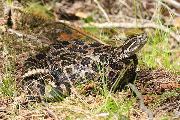
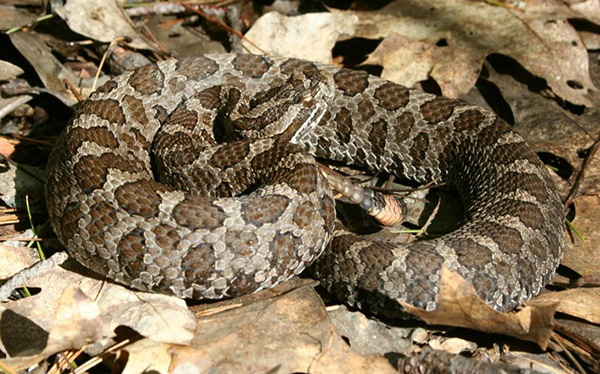
The Massasauga, eastern Canada’s only venomous snake, is a stout-bodied, relatively small rattlesnake. Adults are typically 50 to 70 cm long. It has a diamond-shaped head, vertical pupils, heat sensitive pits on each side of the face between the nostril and eye, and the tail ends in a small, well-developed rattle. The rattle is made up of loosely attached segments of keratin that vibrate against each other and create a rattle or buzzing sound when the tail is shaken. The sides and back of the Massasauga are typically grey to dark brown, with a row of darker brown butterfly or saddle-shaped blotches down the centre of the back alternating with rows of smaller lateral spots, providing camouflage in its typically vegetated surroundings. The ventral scales are dark brown or black, often with white mottling. Young snakes resemble the adults - except that the rattle is less developed and their background colouration is greyer, resulting in a greater contrast with the brown blotches. A more detailed account of the Massasauga can be found in McDiarmid et al. (1999).
3.2 Population and distribution
The Massasauga occurs in the Great Lakes Region, including portions of Ontario and ten U.S. states (Figure 1). The species range extends west from New York State to Minnesota and Iowa, reaching the southern limit of its range in Illinois and Missouri, and the northern limit in central Ontario. Although the global range is similar to what was seen historically, and the distribution of the Massasauga has always been somewhat discontinuous (Beltz 1993), over time it has become increasingly fragmented and populations have become smaller and more isolated as the result of human development (Szymanski 1998; Rouse and Willson 2002).
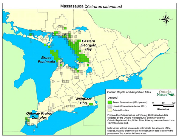
In Ontario, the Massasauga occurs as four distinct regional populations: 1) Ojibway Prairie Complex in the City of Windsor and the Town of LaSalle; 2) Wainfleet Bog near Port Colborne; 3) Bruce Peninsula (including Manitoulin Island, Vidal Island, and Fitzwilliam Island); and 4) eastern Georgian Bay (including Big Chute on the Trent-Severn Waterway) (Figure 2). Historically, the Massasauga was once more widespread in southwestern and west-central Ontario (Szymanski 1998). They may also have occurred along the north shore of Lake Ontario (Weller and Oldham 1993), although this has not been confirmed.
Figure 1. Global Range and Distribution of the Massasauga.
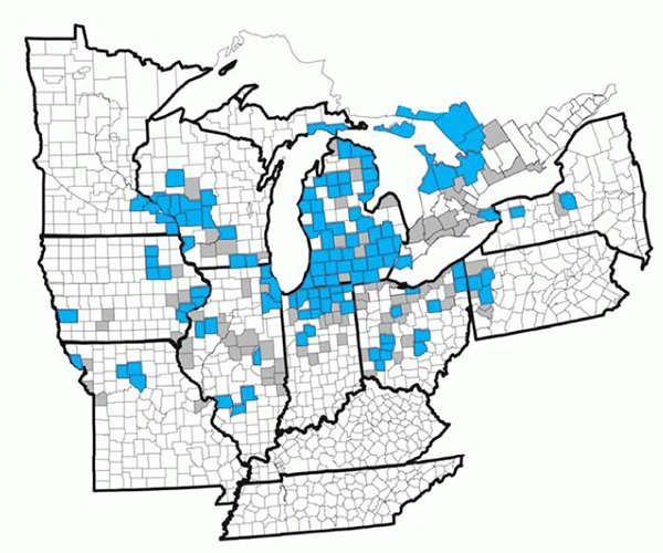
Current (blue) and historic (grey) range of the Massasauga in the Great Lakes Region by county and district (modified from Ray 2009 and USFWS 2009) (Sudbury District was clipped back to the south end of its huge boundaries, to where the Massasauga actually occurs, to prevent a false impression of the northern extent of the species). Note that massasaugas in southwestern Iowa and western Missouri are generally considered to be the Western Massasauga (Sistrurus c. tergeminus).
It is estimated that as much as half of the historical range of the species in Ontario has been lost over the past two centuries (Weller and Oldham 1993).
In Ontario, the Massasauga occurs in some habitats considered as rare ecological communities. The Ojibway Massasauga population is the only one remaining today in Canada in tallgrass prairie-savannah, a vegetation community type which spread for approximately 820 km2 in the pre-settlement landscape of southern Ontario (Rodger, 1998). The extent of occurrence (EO)
The size of the Massasauga population in Canada is difficult to determine or even estimate, due to the species' cryptic behaviour and the general inaccessiblity of much of its habitat. The relative size of each of the regional populations is believed to be roughly proportional to the amount of habitat in each area (Rouse and Willson 2002). Estimates of the number of mature individuals in Ojibway (10-15) (Pratt pers. comm. 2010) and Wainfleet (40-70) (Yagi pers. comm. 2009) are several orders of magnitude smaller than for the Bruce Peninsula (4,000-8,000) and eastern Georgian Bay (13,000-22,000) (Rouse and Willson 2002). More recent studies estimated approximately 10,000 snakes on the upper Bruce Peninsula (Harvey 2008).
Genetic differences among the four regional populations are sufficient to suggest isolation occurred prior to European settlement (Gibbs et al. 1997). The Massasauga displays high levels of genetic differentiation (overall hFst = 0.21) and populations represent unique genetic clusters even at regional spatial scales (Chiucchi and Gibbs 2010).
3.3 Needs of the Massasauga
The Massasauga hibernates for up to six months of the year in rodent and crayfish burrows, root systems, rock crevices, and sphagnum hummocks (e.g. Harvey and Weatherhead 2006a). Hibernation sites must provide insulated and moist subterranean spaces below the frost line where individuals can avoid freezing and dehydration (Sage 2005). Individuals tend to show hibernation site fidelity, although exceptions have also been observed. At Wainfleet, snakes rarely used the same hibernation tunnel in subsequent years, but certainly were within 100m of the old site (Yagi pers. comm. 2011). Massasaugas hibernate either singly or in small groups or clusters, aggregating where favourable microhabitats occur.
The Massasauga is an opportunistic ambush predator that feeds primarily on small mammals (Weatherhead et al. 2009), and this has significant implications for how they use macrohabitat versus microhabitat for thermoregulation and the effectiveness of this thermoregulation (Harvey and Weatherhead 2006b). Younger individuals consume a wider range of prey including snakes, frogs, and invertebrates (Shepard et al. 2004). The Massasauga remains close to vegetative ground cover during the active season, likely to reduce predation risk (Harvey and Weatherhead 2006b). Although Massasaugas have specific habitat requirements for hibernation and gestation, during the active season they tend to be habitat generalists, using a variety of habitat types (Harvey and Weatherhead 2006b). It may be simpler to list what they don't use: dense forests, open water, and areas with little to no ground cover (e.g. wide, sandy beaches). Foraging conditions are ideal when canopy closure is less than 50% (Harvey 2006) and vegetative ground cover is greater than 60% (Bissell 2006). Fire has been an important disturbance factor at Wainfleet Bog as well as at Cicero Swamp in New York State. In both wetlands the old burn areas are now the most used habitats by the Massasauga (Yagi pers. comm. 2011).
Figure 2. Massasauga range and distribution in Ontario by regional population.
Enlarge Figure 2. Massasauga range and distribution in Ontario by regional population map.
Courtesy of the Ontario Reptile and Amphibian Atlas Project, Ontario Nature.
The Massasauga is live-bearing and requires approximately three months of gestation prior to giving birth. Gestation occurs where thermal conditions are favourable for embryonic development (Harvey 2006). Gestation sites must have low crown closure, surrounding vegetative ground cover, and a feature that provides relatively warm refuge during cool weather (e.g. large rock, beaver lodge, stump, brush or debris pile). Local gestation sites may be used by several females in a given season and are often used by the same individuals in successive breeding years. Because the active season is short (approximately 6 months, May to October) and the gestation period relatively long in Ontario, most females are believed to only be able to acquire the necessary energy to reproduce every two to three years. Low juvenile recruitment likely limits the northern distribution of the species and is probably an important limiting factor in all Ontario populations (Harvey 2006).
For populations of the Massasauga to persist they need access to hibernation sites, gestation sites, and foraging habitat. Hibernation sites are often located on the periphery of individual home ranges. Telemetry data from Ontario indicates movements of greater than 2 km linear distance from hibernation site to maximum edge of activity range (Harvey unpublished data, Yagi unpublished data). Population viability may be threatened if commuting corridors are obstructed by significant barriers (e.g. housing, roads) which hinder movements, isolate habitat components, and potentially increase anthropogenic mortality.
Estimates of home range size (1-136 ha) vary widely between populations; home range size is likely a function of the relative proximity of the requisite habitat components and prey density (Reinert and Kodrich 1982, Durbian et al. 2008). Durbian et al. (2008) recommended
Massasauga refuges of at least 100 ha of contiguous area in order to support viable populations, based on studies in the American Midwest. Given the geographic variation in home range size, minimum habitat areas to support viable populations in Ontario may need to be somewhat larger than 100 ha.
4. Threats
4.1 Threat assessment
Threats to the Massasauga are primarily related to human population growth in southern Ontario and associated influences on the natural environment, including habitat loss, fragmentation, and road mortality. Persecution, collection for the pet trade, forest management entailing large clear cuts, and peat extraction, have all been detrimental to the survival of the species.
Table 2. Threats to Massasauga recovery.
Habitat loss and degradation
| Threat | Level of concern | Extent | Occurrence | Frequency | Severity | Causal certainty |
|---|---|---|---|---|---|---|
| Development - roads | High | Widespread | Current | Continuous | High | High |
| Development - other than roads (e.g., housing, golf courses, agriculture) | High | Widespread | Historic and Current | Continuous | High | High |
| Peat extraction | High | Localized | Historic | Continuous | High | High |
| Mineral extraction | High | Localized | Historic and Current | Continuous | High | High |
| Forest management | Medium | Historically widespread, currently localized | Historic and Current | Continuous | Unknown | Low |
Disturbance or persecution
| Threat | Level of concern | Extent | Occurrence | Frequency | Severity | Causal certainty |
|---|---|---|---|---|---|---|
| Discriminate killing | Medium High | Widespread | Historic and Current | Seasonal | Historically High, Currently Medium | High |
| Recreational vehicle use | Medium | Widespread | Historic and Current | Continuous | Unknown | Low |
Consumptive use
| Threat | Level of concern | Extent | Occurrence | Frequency | Severity | Causal certainty |
|---|---|---|---|---|---|---|
| Pet trade | Low (high for Wainfleet and Ojibway populations) | Widespread | Historic and Current | Seasonal | Low - Medium | Low - Medium |
Natural processes or activities
| Threat | Level of concern | Extent | Occurrence | Frequency | Severity | Causal certainty |
|---|---|---|---|---|---|---|
| Small population size | Unknown | Localized | Current | Continuous | Unknown | Medium |
Level of Concern: signifies that managing the threat is of (high, medium or low) concern for the recovery of the species, consistent with the population and distribution objectives. This criterion considers the assessment of all the information in the table).
Severity: reflects the population-level effect (High: very large population-level effect, Moderate, Low, Unknown).
Causal certainty: reflects the degree of evidence that is known for the threat (High: available evidence strongly links the threat to stresses on population viability; Medium: there is a correlation between the threat and population viability e.g. expert opinion; Low: the threat is assumed or plausible).
4.2 Description of threats
-
Development – roads (construction of new roads and improvement of existing)
Snakes may be killed during the construction or upgrading of roadways or while crossing or basking on existing roads. Road kill may be extensive in areas where roadways intersect with snake movement paths (Weatherhead and Prior 1992). This includes minor roads such as cottage and forest management access roads. Road mortality tends to be male-biased and concentrated in late summer when males are actively searching for mates (Shepard et al. 2008a). Further to increases in direct mortality, roads may serve as an impermeable or semi-permeable barrier to snake movement (Shepard et al. 2008b), resulting in 1) habitat degradation and 2) population fragmentation.
-
Development – other than roads
Many types of development (e.g. housing, golf courses, agriculture) negatively impact the Massasauga via direct loss of habitat, habitat fragmentation, and the increased likelihood of a lethal human encounter (e.g. discriminate killing). An increased human presence in an area can also have subtle effects on snake behaviour with negative fitness consequences (e.g. reproductive rate (Parent and Weatherhead 2000)). The largest remaining Massasauga populations (Bruce Peninsula, eastern Georgian Bay) clearly inhabit the least developed areas of the species' historic range in Ontario (Crowley 2006). Threats from development are particularly acute for the Ojibway and Wainfleet populations that are surrounded by urban and agricultural development, respectively.
-
Forest management
Forest management operations pose a risk to the Massasauga and its habitat requirements. Mitigation measures implemented in Massasauga habitat can help reduce this risk. Access roads not decommissioned post-harvest continue as a contributor to direct snake mortality.
-
Peat extraction
An historic threat unique to the Wainfleet population, is peat extraction. This activity lowers the elevation of the aerobic peat layer, thus reducing the space between the water table, frost line, and any remaining aerobic peat soil. It thus reduces the quality of hibernation habitat, by rendering hibernation sites vulnerable to stochastic flooding events once drains are no longer maintained (Yagi and Planck, In Prep).
-
Mineral extraction
Mineral aggregate extraction activities on Crown and private lands in the eastern Georgian Bay and Bruce Peninsula Massasauga regional populations including road construction, quarrying, blasting, and excavation continue to be a major concern.
-
Discriminate killing, the pet trade, and inappropriate releases
Discriminate killing is a direct threat faced by all snakes, non-venomous and venomous, including the Massasauga. Education and awareness initiatives have reduced this threat, but are unlikely to eliminate it entirely (e.g. Christoffel 2007). Poaching for the pet trade is known to have occurred recently in Ontario. Besides directly reducing the viability of small populations (e.g. Ojibway and Wainfleet), removal of individuals may promote disease transmission and gene pool contamination if they are subsequently released in areas other than where they were caught. Gravid females may be especially conspicuous, due to their tendency to bask in the open, therefore they may be disproportionately targeted for discriminate killing and collection (Harvey 2006). In addition to the removal of individuals over the years, evidence of inappropriate releases of the Massasauga into Wainfleet Bog has been recently documented using DNA analysis (Yagi pers. comm. 2011).
-
Recreational vehicle use
Populations on the Bruce Peninsula and eastern Georgian Bay are particularly vulnerable to the impacts of recreational vehicle use, with direct mortality to individuals. There is also a minor impact to Massasauga habitat with uncontrolled vehicle use.
-
Small population size
Populations at Ojibway and Wainfleet are isolated and relatively small compared to the northern populations, and thus have an increased risk of extirpation from stochastic events (e.g. disease and flooding). Early spring flooding, followed by a freeze, is suspected of having impacted the Ojibway population, as these conditions likely contributed to the death of a number of individuals translocated into Ojibway Prairie Provincial Nature Reserve in 2006-07.
Other potential threats
The widespread degradation of suitable habitat and the trend in southern Ontario of forested areas closing in from succession present significant challenges in maintaining the species on the landscape over the long term. Wildfire occurred at many sites on the Bruce Peninsula over the past 150 years (Schaefer 1996, Jones and Reschke 2005), and the Massasauga likely continues to benefit today from habitat created by those fires. While it can be difficult to gauge the effects or urgency of the threat of succession, creative ways of incorporating disturbance into these natural systems, e.g. prescribed burning, vegetation management, good forest management practices, or flooding (e.g. via beaver meadow cycle), should be considered.
Although the impact of hydro-electric dams has not been studied directly, there is good reason to believe that their construction and operation results in the destruction of habitat and is a threat to the Massasauga. Hydro-electric dams predictably flood impoundments. If an area used as habitat by the Massasauga (e.g. hibernacula) becomes flooded, it will be open water and no longer suitable. In addition, the effects of road development and construction, which are elements of hydro development, are well documented. There are currently hydro proposals within the range of the Massasauga. With the current influx of hydro proposals in Ontario, this is likely to become a more prevalent threat to the species.
5. Populations and distribution
5.1 Population and distribution objectives
The long-term recovery goal for the Massasauga in Ontario is the persistence of the species throughout its current range, by preventing extirpation of the Ojibway population; securing viable populations at Wainfleet, the Bruce Peninsula, and eastern Georgian Bay; and retaining a sufficient distribution and degree of habitat connectivity among local populations to maintain the current extent and area of occupancy throughout the Bruce Peninsula and eastern Georgian Bay regional populations. Although the Massasauga has been the subject of several studies, there are still many knowledge gaps that complicate recovery planning and prevent the articulation of specific quantitative objectives. For example, it is unclear how many snakes would be required to ensure a 90% probability of persistence over 100 years, or how much habitat would be required to support a viable population. Consequently, the following objectives focus on the maintenance of populations and/or habitat, while the feasibility of population augmentation and habitat restoration are explored.
- Ojibway:
- Maintain the habitat in Ojibway to allow for the survival of the extant individuals while the probability of long-term persistence of the population is assessed;
- Maintain the current distribution (5 km2 extent of occurrence, 6 km2 area of occupancy
footnote ii ); - Determine the feasibility of population augmentation and habitat restoration to increase population size and distribution.
- Wainfleet:
- Maintain the Wainfleet population of the Massasauga;
- Maintain the current distribution (6.9 km2 extent of occurrence, 10 km2 area of occupancy);
- Determine the feasibility of population augmentation and habitat restoration to increase population size and distribution.
- Bruce Peninsula (including Manitoulin, Vidal, and Fitzwilliam Islands):
- Maintain the Bruce Peninsula regional population of the Massasauga;
- Maintain the current distribution (1,594 km2 extent of occurrence, 512 km2 area of occupancy).
- Eastern Georgian Bay (including Big Chute):
- Maintain the Georgian Bay regional population of the Massasauga;
- Maintain the current distribution (8,466 km2 extent of occurrence, 1,108 km2 area of occupancy).
Rationale
The objectives listed above are based on criteria that are considered by COSEWIC when assessing a wildlife species' risk of extinction (COSEWIC 2009), and specifically those under which the Massasauga was designated in 2002 (COSEWIC). The species was confirmed as Threatened because of its continuing decline in distribution and abundance. Distribution parameters (extent of occurrence and index of area of occupancy) were chosen as recovery targets because population size requirements for viability are currently unclear due to the difficulty in obtaining the demographic information necessary to make population viability assessments (Harvey 2008). By meeting these objectives, the recovery goal of long-term persistence of this species throughout its current range will likely be achieved.
6. Broad strategies and approaches to recovery
6.1 Actions already completed or currently underway
The Massasauga Recovery Team, led by Parks Canada, has been active for over 15 years. During this period, many recovery tasks have been accomplished in the areas of habitat restoration, scientific research, public outreach, and policy formulation.
6.2 Strategic direction for recovery
Table 3. Broad strategies and approaches needed to achieve the population and distribution objectives for the Massasauga.
| Priority | Threat(s) addressed | Broad strategies to address threat(s) | Recommended approaches |
|---|---|---|---|
| High | Roads | Habitat management and protection, Communication and outreach, Research |
|
| High | Habitat loss and degradation | Habitat management and protection, Habitat restoration, Communication and outreach, Research, Traditional Ecological Knowledge |
|
| Medium | Discriminate killing | Communication and outreach |
|
| Medium | Pet trade | Communication and outreach |
|
| High (at Ojibway and Wainfleet only) | Small population size | Habitat management and protection, Population management |
|
6.3 Narrative to support the recovery planning table
Recovery for the two southern populations focuses on habitat management and protection, whereas the larger northern populations support more active research programs (e.g. Pratt et al. 1999, Yagi and Planck In prep, Harvey 2006, Rouse 2006). Public outreach and awareness programs are active throughout Ontario. A Species Survival Plan (SSP) for the Massasauga is being developed by the American Zoo and Aquarium Association (Earnhardt et al. 2009). In addition to increasing public awareness through educational programs, an SSP establishes a captive population as an insurance policy, should reintroduction be required at some time in the future. In 2003, four massasaugas (including two gravid females) were rescued from an imminent development project at Ojibway and housed at the Toronto Zoo, where the two gravid females gave birth. In 2006, 27 of these captive-born massasaugas were repatriated into the Ojibway Prairie Provincial Nature Reserve, but were unable to successfully colonize the area. In 2011 the Massasauga Recovery Team resolved that given the current population estimate for Ojibway, that the remaining individuals should be captured and brought into captivity, to prevent the loss of this genetic stock. Because population size estimation is problematic for the Massasauga, relatively coarse measures (e.g. presence/absence, habitat availability) may be required to gauge the efficacy of recovery efforts (Harvey 2008).
First Nation communities have maintained local ecosystems for generations through the use of community Traditional Ecological Knowledge. It is important to gather and share Traditional Ecological Knowledge from Knowledge Holders to others as a means for species and ecosystem protection and recovery. Traditional Ecological Knowledge and science can, together, better inform assessment, monitoring, and recovery of the ecosystems that support specific species at risk.
7. Critical habitat
SARA defines critical habitat as the habitat that is necessary for the survival or recovery of a listed wildlife species and that is identified as the species' critical habitat in the recovery strategy or in the action plan for the species. It must be identified in a recovery strategy or action plan, to the extent possible using the best available information. The purpose of identifying critical habitat is to then ensure that it is protected from human activities that would result in its destruction. Both location and biophysical characteristics of critical habitat need to be described.
Critical habitat is identified in this strategy for the four population regions (Figure 3), based on the best existing available information. This is not a complete identification, as critical habitat has not been identified on First Nation reserves. The Government of Canada continues to work with First Nations towards identification of critical habitat and will update this document as appropriate, once cooperation and consultation efforts are completed.
A schedule of studies, which outlines the work required to complete the identification of critical habitat, is included below. Future identification of critical habitat will also be undertaken, as needed, to support the population and distribution objectives of the species, if future information indicates it is necessary. Critical habitat for all populations may be refined as better information becomes available. Differences inherent to the southern versus the northern populations necessitated the use of different methods for identification, as described below.
7.1 Information and methods used to identify critical habitat
The locations and attributes of critical habitat were identified using confirmed records of the species. The main source of information on the Massasauga for all four regions was observation data from the Natural Heritage Information Centre (NHIC) in Peterborough, Ontario (NHIC 2010), including NRVIS (Natural Resource Values Information System) data. The NHIC compiles data from a variety of sources (e.g. Ontario Ministry of Natural Resources, Parks Canada, the general public, university researchers, consultants, aboriginal, and local knowledge), and of different types (e.g. opportunistic, surveys, telemetry). As the Massasauga is a cryptic species, and challenging to census, observations from a 40 year period, 1971 to 2010, were used in the calculations for critical habitat. For records with an accuracy measure indicated, only those of 100 metres or better were accepted. Any records from anonymous observers were rejected.
Figure 3. Areas within which critical habitat for the Massasauga is found at the four regional populations.
-
Southwestern Ontario regional populations (Ojibway and Wainfleet)
In southwestern Ontario, the Massasauga is restricted to a few of the last remaining natural and semi-natural sites in the Ojibway area and in the Wainfleet area. At Wainfleet, all of the few natural and semi-natural sites that remain and within which Massasauga were observed in the 1971 to 2010 period have been identified as critical habitat. For Ojibway, the three primary sites which provide supporting habitat for the Massasauga, and in which the species has been observed in the 1971 to 2010 period, have been identified as critical habitat: Ojibway Prairie Provincial Nature Reserve, Spring Garden Natural Area, and LaSalle Woodlot. While this approach captures the majority of occurrences of the species over the past 40 years, the Ojibway landscape in particular is highly fragmented, and not all semi-natural remnants where snakes have been observed are considered to be critical habitat. It is recognized that the current methods do not satisfy all the needs of the Massasauga at Ojibway, nor perhaps at Wainfleet, and that other tools must be drawn upon to meet these needs, some having already been utilized for years, e.g. acquisition of potential habitat, and restoration of such habitat to a natural state.
The three critical habitat parcels at Ojibway total 413ha (77ha - LaSalle Woodlot, 175ha - Ojibway Prairie Provincial Nature Reserve, and 161ha - Spring Garden Natural Area). Natural boundaries were defined where possible by interpretation of 30cm resolution orthophotography from 2006 (South Western Ontario Orthorectification Project 2006), and were reviewed by local experts.
The fact that Ojibway Prairie Provincial Nature Reserve and Spring Garden Natural Area are above the threshold of 100ha to sustain a viable population (see Durbian et al. 2008), and that there have no been observations of the Massasauga within these properties in the past ten years, brings into question the use of size alone as a determinant of population viability. Although size is likely important, there are other variables we need to consider in determining the long term viability of subpopulations within core areas (e.g. the effect of intensive management regimes such as fire, edge effects resulting in increased access by poachers, road mortality, persecution, etc.). It is thus also acknowledged that the presence and extent of existing and additional threats might reduce the ability of even large core reserves to maintain this population at the Ojibway area into the long term.
The Wainfleet critical habitat tract is 1581 ha. Permanent open water areas within the wetland feature at Wainfleet are not considered critical habitat.
-
Bruce Peninsula and Eastern Georgian Bay regional populations
Massasauga habitat in the Bruce Peninsula and in eastern Georgina Bay is still widespread, despite the loss of habitat over the past century. Critical habitat is identified using an occurrence-based approach, by plotting all valid records and buffering the centroid of these occurrences with a 1.2km radius, to capture most of the home range for any occurrence. This is founded on the average maximum distance that snakes move from hibernacula over the course of an active season, as derived from detailed radio telemetry studies on the Bruce Peninsula (Harvey, unpublished) and eastern Georgian Bay populations (Rouse et al. 2011). These polygons were modified to eliminate open water, but permanent and non-permanent wetlands were included. The occurrence-based approach can only be applied to lands where occurrences have been recorded, by definition. We are not able to identify critical habitat on landscape characteristics alone at this time.
In total, 8810 observation records of the Massasauga for the Bruce Peninsula (2085) and eastern Georgian Bay (6725) ranges were used to identify and plot critical habitat. A total of 567km2 of critical habitat is identified for the Bruce regional population and 1371km2 for the eastern Georgian Bay regional population. These totals currently exceed the respective index of area of occupancy objectives for the two ranges of 512km2 and 1108km2 respectively. Critical habitat represents the area necessary for the survival or recovery of the species, while the IAO represents the area in which snakes have been detected with a given search effort. An allowance is made for a slightly larger area containing critical habitat, as it is based on a 40 year sampling regime, rather than the 20 years required by COSEWIC for the IAO.
7.2 Geographic locations and biophysical attributes of critical habitat
Using the methods described above, critical habitat has been identified in all four regions of Massasauga occurrence (Figure 3). Overview maps of the four regional populations are provided in Figures 4 through 7 below, while detailed maps of the critical habitat parcels for Wainfleet and Ojibway are illustrated in Figures 8 and 9 of Appendix B. Detailed maps depicting the locations of critical habitat for the Massasauga can be found on the Government of Canada’s Species at Risk (SAR) Public Registry.
For the four regional populations, critical habitat within the areas indicated in Figures 4-7 is identified as the habitat meeting the biophysical attributes described below. Unsuitable habitat within these areas, such as existing infrastructure (e.g. roads, trails, parking lots, and buildings), the footprint of existing cultivated areas (e.g. agricultural fields), or unnatural vegetation types (e.g. baseball fields, manicured lawns, and septic beds), is not necessary for the survival or recovery of the Massasauga, and is thus not critical habitat.
For the areas within the identified critical habitat to function as such, the following biophysical attributes (almost all of which have been adopted from the Guidelines for Identifying Significant Habitat, Eastern Massasauga Recovery Team 2005) apply:
- Hibernation site attributes:
- On the Bruce Peninsula, sites are typically located in forested areas (dense and sparse forest) on karst topography with fissures extending to ground water.
- In eastern Georgian Bay, sites are most often found in conifer or shrub swamps and swales, poor fens, or depressions in bedrock terrain where water saturated soils have supported the development of vegetation communities characterized by sparse tree cover or shrubs with sphagnum moss or sedge hummock ground cover.
- Insulated and moist subterranean spaces that are aerobic and frost free, where individuals can avoid freezing and dehydration.
- Gestation & Basking site attributes:
- Sites are typically found in areas of low canopy cover, such as forest openings, areas of bedrock outcropping, alvars, and along the shorelines of water bodies.
- Characterized by the presence of large table rocks (typically 1 x 1.5 m), flat (usually no more than 0.30m thick) with portions lying slightly raised off the substrate or perched so that an opening exists underneath.
- They are usually surrounded on several sides by grass or low-lying shrubs.
- In areas devoid of large, flat table rocks, functionally equivalent rock piles, raised cobble beaches, old tree stumps, earth mounds, brush and debris piles, may be used.
- Foraging & Mating site attributes:
- Sites where physical and vegetative structures support populations of small rodents, the snake’s principal prey. These include marshes, fens and swamps, fields and grasslands, sparse forests, as well as edge habitats, such as the periphery of alvars and rock outcrops. In heavily forested areas, the edges of human created clearings, such as hydro lines, railway lines, and road edges may be particularly favoured (e.g. Harvey and Weatherhead 2006b).
Revision of critical habitat would take place periodically, as further information on the species becomes available.
Figure 4. Areas within which critical habitat for the Massasauga is found at the Bruce Peninsula regional population.
Figure 5. Areas within which critical habitat for the Massasauga is found at the Eastern Georgian Bay regional population.
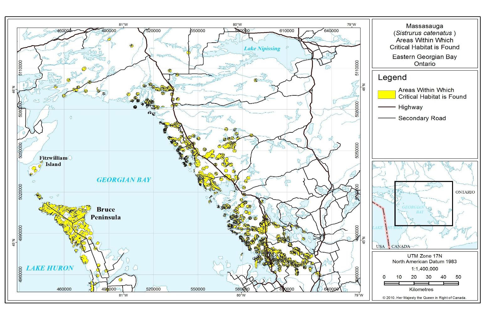
Figure 6. Critical habitat for the Massasauga at Wainfleet.
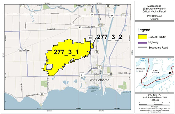
Enlarge Figure 6. Critical habitat for the Massasauga at Wainfleet map.
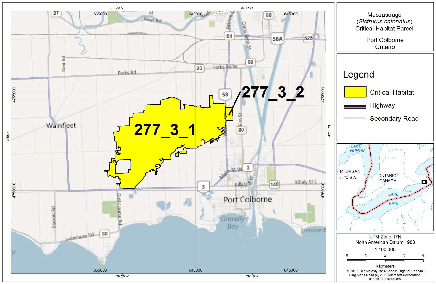
Figure 7. Critical habitat for the Massasauga at Ojibway.
Enlarge Figure 7. Critical habitat for the Massasauga at Ojibway map.
7.3 Activities likely to result in the destruction of critical habitat
Activities that are likely to result in the destruction of critical habitat are provided in Table 4. Destruction is determined on a case-by-case basis. Destruction of critical habitat would result if any part of the critical habitat were degraded, either permanently or temporarily, such that it would not serve its function when needed by the species. Destruction may result from single or multiple activities at one point in time, or from the cumulative effects of one or more activities over time, depending on their frequency and intensity.
In the Bruce Peninsula and Georgian Bay regions, where large amounts of natural habitat remain, some activities conducted in isolation are unlikely to destroy critical habitat. Low intensity development (e.g. single residence, hiking trail) results in minimal loss and/or fragmentation of natural habitat, which may be balanced by an increased prey availability in these areas (Eastern Massasauga Recovery Team 2005). The federal government will work with provincial regulatory authorities and land users to develop a better understanding of cumulative effects, thresholds of activities leading to destruction, and mitigation guidelines (such as restrictions on activities in certain areas and over certain time periods), with a view to supporting the development of a best management practices guidance document for the Massasauga, for use by planners and others.
In the Ojibway and Wainfleet regions, where little natural habitat remains and populations are small and tenuous, it is believed that cumulative activities (in particular habitat loss) have already surpassed the threshold, such that the survival of local populations is already jeopardized. Therefore, any additional activity listed in Table 4 would constitute destruction of critical habitat in those regions.
Table 4. Examples of activities likely to result in the destruction of critical habitat.
| Activity likely to destroy critical habitat | Potential effect(s) on attributes at local scale | Potential effect(s) on attributes at landscape scale |
|---|---|---|
|
|
|
|
|
|
|
|
|
|
|
|
7.4 Schedule of studies to identify critical habitat
To complete critical habitat for the species, the federal government will work with First Nations and relevant federal departments on the further identification of critical habitat on federal lands.
| Description of activity | Outcome/rationale | Timeline |
|---|---|---|
| The federal government will continue to work with First Nations to complete the identification of all known critical habitat on First Nation reserve land, by applying the 1.2 km radius around valid occurrences adjacent to reserve lands. | Critical habitat mapped in part on FNs lands, if appropriate. | 5 years (dependent on progress respecting consultation with FNs). |
| The federal government will continue to work with First Nations to complete critical habitat identification on First Nation reserve land, including a method for sharing information regarding occurrences on reserve lands. | Critical habitat mapped in entirety on FNs lands, if appropriate. | On-going, pending progress respecting consultation with FNs. |
| Parks Canada will work with other federal departments to determine whether individuals and suitable habitat are present at federal properties. | Status of species on federal properties determined, with critical habitat identified and mapped, if appropriate. | 3 years. |
8. Additional information requirements about the species
Available knowledge is adequate to set sound recovery objectives. However certain gaps remain, limiting the extent to which recovery actions can be specified.
Survey requirements
- Conduct inventories in remaining natural areas at the Ojibway regional population to determine movement patterns and whether corridors should be identified as critical habitat.
- Additional surveys to update our knowledge of the species' distribution for the Bruce and eastern Georgian Bay regional populations. Current data is highly biased towards roads and publicly accessible lands.
- Survey selected isolated sites with observations older than 30 years to test the reliability of older observations.
- Better documentation of research effort in inventories of this species is needed to calibrate observation data over time.
Biological and ecological research requirements
- Establish demographic targets for population viability and the quantity of habitat required for population persistence.
- Estimate the feasibility of achieving viable populations in Ojibway and Wainfleet.
- Juvenile mortality in the Massasauga is known to be high, ranging from 50-70% in the first year (Szymanski 1998). Age-based mortality curves would be helpful for all four regional populations.
- At Wainfleet there is a significant gap in our knowledge of neonate and juvenile habitat use, behaviour, and survival.
- Translocation as a management tool needs further evaluation, as well as research on augmentation and repatriation, to determine whether they can be used effectively for the small southern populations in particular.
- Headstarting neonates or mass breeding and release of neonates need to be tested as viable management options for Ojibway and Wainfleet.
- Fine-scale estimates of genetic structure and the mechanisms by which it is maintained will improve our understanding of how to manage for population viability and connectivity (Lougheed et al. 2000).
- Develop a better biologically-based understanding of cumulative effects, the thresholds at which various activities lead to destruction at the landscape scale, i.e. > 1ha, and a system for tracking cumulative habitat loss.
- Develop a model for the identification of habitat for the purpose of maintaining connectivity between sub-populations.
- Evaluate whether the 2005 Guidelines for Identifying Habitat require updating for the current application of identifying the biophysical attributes of critical habitat under SARA.
Threat clarification and mitigation research requirements
- Research and analysis is also underway at Wainfleet to understand the impact of the restoration of mined peatlands (includes manipulation of the water table, re-creation of hummock/hollow microtopography, cutting of non-native European Birch, and planting of native bog species) on the existing Massasauga population there (Yagi and Planck In prep).
9. Measuring progress
Evaluation of the progress toward achieving Massasauga recovery will be reported in five years following final posting of this recovery strategy on the Species at Risk Public Registry, and every five years following, as per SARA (s. 46). The criteria indicated in Table 5 will be used to evaluate the progress of the overall recovery strategy for the Massasauga. Each of the criteria is directly linked to the key objectives of this recovery strategy, as indicated.
Table 5. Performance measures for progress of Massasauga recovery.
| Criteria | Links to objective number | Evaluation timeframe (years after final posting of recovery strategy) |
|---|---|---|
| 1. Index of area of occupancy for the 4 regional populations maintained at current levels. This would include new target areas for inventory in the species' range which are not well inventoried, with prioritized search effort, and a focus on 30-year+ observations. Habitat suitability models developed for eastern Georgian Bay and the Bruce Peninsula will be considered to help predict areas with preferred biophysical attributes. | 1,2,3,4 | Measured at five-year intervals |
| 2. Extent of occurrence for the 4 regional populations maintained at current levels. | 1,2,3,4 | Measured at five-year intervals |
| 3. Targets established for population viability and quantity of habitat required for population persistence. | 1,2,3,4 | 5 |
| 4. Application of existing knowledge or new research into the most efficient means of affording protection for corridors among local populations. | 1,2,3,4 | Measured at five-year intervals |
| 5. A communications strategy developed for the 4 regional populations, targeted to private landowners and stewardship practices. | 1,2,3,4 | 3 |
| 6. A dialogue begun with First Nations partners and stakeholders e.g. municipalities and corporate quarry owners, about stewardship possibilities. | 1,2,3,4 | 3 |
| 7. Research into appropriate habitat management initiated e.g. Bruce: experimental burns on alvar; Wainfleet: openings managed by beaver-meadow cycle to create gestation sites, abundant feeding areas. | 1,2,3,4 | 5 |
10. Statement on action plans
One or more action plans will be completed by December 2020.
References
Beltz, E. 1993. Distribution and status of the eastern massasauga rattlesnake, Sistrurus catenatus catenatus (Rafinesque, 1818), in the United States and Canada. Pp. 26-31 in B. Johnson and V. Menzies (eds.), International Symposium and Workshop on the Conservation of the Eastern Massasauga, Toronto Zoo, Toronto, ON.
Bissell, K. M. 2006. Modeling habitat ecology and population viability of the eastern massasauga rattlesnake in southwestern lower Michigan. MSc thesis, Michigan State University, East Lansing, MI.
Chiucchi, J.E. and H.L. Gibbs. 2010. Similarity of contemporary and historical gene flow among highly fragmented populations of an endangered rattlesnake. Molecular Biology 19: 5345-5358.
Christofell, R. A. 2007. Using human dimensions insights to improve conservation efforts for the eastern massasauga rattlesnake (Sistrurus catenatus catenatus) in Michigan and the timber rattlesnake (Crotalus horridus horridus) in Minnesota. PhD thesis, Michigan State University, East Lansing, MI.
COSEWIC. 2009. Wildlife Species Assessment. COSEWIC's Assessment Process and Criteria. Government of Canada.
Crowley, J. 2006. Are Ontario reptiles on the road to extinction? Anthropogenic disturbance and reptile distributions within Ontario. M.Sc. Thesis, University of Guelph, Guelph, ON.
Durbian, F. E., King, R. S., Crabill, T., Lambert-Doherty, H. and Seigel, R. A. 2008. Massasauga home range patterns in the Midwest. Journal of Wildlife Management 72: 754759.
Earnhardt J., Mulkerin, D., Long, S. and Groome, C. 2009. Population analysis and breeding plan update May 2009: eastern massasauga rattlesnake Sistrurus catenatus catenatus Species Survival plan. Unpublished report for the Population Management Center, Lincoln Park Zoo, Chicago, IL.
Eastern Massasauga Rattlesnake Recovery Team and Toronto Zoo. 2002. The Eastern Massasauga Rattlesnake Stewardship Guide: A Resource and Field Guide for Living with Rattlesnakes in Ontario. Habitat Stewardship Program for Species at Risk. 84pp.
Eastern Massasauga Rattlesnake Recovery Team. 2005. Guidelines for Identifying Significant Habitat, and Significant Wildlife Habitat, for the Eastern Massasauga Rattlesnake in Eastern Georgian Bay and Bruce Peninsula Populations, Ontario. Version 1.1, July 2005. 20pp.
Gibbs, H. L., Prior, K. A., Weatherhead, P. J. and Johnson, G. 1997. Genetic structure of populations of the threatened eastern massasauga rattlesnake, Sistrurus c. catenatus: evidence from microsatellite DNA markers. Molecular Ecology 6: 1123-1132.
Harvey, D. S. 2006. The role of temperature in habitat selection by eastern massasaugas rattlesnakes (Sistrurus catenatus catenatus) near their northern range limit. PhD thesis, University of Illinois, Urbana-Champaign.
Harvey, D. S. 2008. Bruce Peninsula National Park / Fathom Five National Marine Park massasauga monitoring – analysis and recommendations. Unpublished report for Bruce Peninsula National Park, Tobermory, ON.
Harvey, D. Unpublished. Notes from field surveys associated with Ph.D. research on Massasauga on the Upper Bruce Peninsula from 2001 to 2004. Provided by Dan Harvey to Parks Canada Agency.
Harvey, D. S. and Weatherhead, P. J. 2006a. Hibernation site selection by eastern massasauga rattlesnakes (Sistrurus c. cateanatus) near their northern range limit. Journal of Herpetology 40: 66-73.
Harvey, D. S. and Weatherhead, P. J. 2006b. A test of the hierarchical model of habitat selection using eastern massasauga rattlesnakes (Sistrurus c. catenatus). Biological Conservation 130: 206-216.
Jones, J.A. and Reschke, C. 2005. The role of fire in Great Lakes alvar landscapes. Michigan Botanist (44)1: 13-27.
Lougheed, S. C., Gibbs, H. L., Prior, K. A. and Weatherhead, P. J. 2000. The relative utility of RAPD versus microsatellite DNA markers for assessing population structure in the eastern massasauga rattlesnake. Journal of Heredity 91: 458-463.
Manly, B.F.J., McDonald, L.L., and Thomas, D.L. 1993. Resource Selection by Animals: Statistical Design and Analysis for Field Studies. Chapman & Hall, London. 177pp.
McDiarmid, R. W., Campbell, J. A. and Touré, J. A. 1999. Snake species of the world: A taxonomic and geographic reference. The Herpetologists' League, Washington, D.C.
Natural Heritage Information Centre (NHIC). 2010. Element occurrence, natural areas, vegetation communities and species databases and species lists. Natural Heritage Information Centre, Ontario Ministry of Natural Resources, Peterborough, Ontario. On-line electronic databases.
NatureServe. 2009. NatureServe Explorer: An online encyclopedia of life [web application]. Version 7.1. NatureServe, Arlington, Virginia. (Accessed: 2009).
NatureServe. 2010. NatureServe Explorer: An online encyclopedia of life [web application]. Version 7.1. NatureServe, Arlington, Virginia. (Accessed: 11 November 2010).
Oldham, M. J., Austen, M., J., and Sorrill, P. J. 1999. A review and evaluation of eastern massasauga observations in Ontario: applications for conservation and management. Pp, 67-76 In: Second International symposium and Workshop on the Conservation of the Eastern Massasauga Rattlesnake, Sistrurus catenatus catenatus: population and habitat management issues in urban, bog, prairie and forested ecosystems. (Bob Johnson and Mark Wright, editors.)
Ontario Nature. 2011. Ontario Reptile and Amphibian Atlas. Web application, updated February, 2011.
Parent, C. and Weatherhead, P. J. 2000. Behavioral and life history responses of eastern massasauga rattlesnakes (Sistrurus catenatus catenatus) to human disturbance. Oecologia 125: 170-178.
Parks Canada Agency. 2010. Unpublished calculations on file at National Office, Gatineau, QC.
Pratt, Paul. 2010. Personal communication with Gary Allen. Paul was the Head Naturalist at the Ojibway Nature Centre, City of Windsor.
Pratt, P. D., Cedar, K. and Pocock, E. 1999. Setting fires and saving rattlers: managing an urban prairie. Pp. 135-136 in B. Johnson and V. Menzies (eds.), International Symposium and Workshop on the Conservation of the Eastern Massasauga Rattlesnake, Toronto Zoo, Toronto, ON.
Ray, J. W. 2009. Conservation genetics and ecological niche modeling of Kirtland’s snake, Clonophis kirtlandii, and the eastern massasauga rattlesnake, Sistrurus catenatus catenatus. MSc thesis, Northern Illinois University, Dekalb, Illinois.
Reinert, H. K. and Kodrich, W. R. 1982. Movements and habitat utilization by the massasauga, Sistrurus catenatus catenatus. Journal of Herpetology 16: 162–171.
Rodger, L. 1998. Tallgrass Communities of Southern Ontario: A Recovery Plan. Prepared for World Wildlife Fund Canada and the Ontario Ministry of Natural Resources. 66 pp.
Rouse, J. D. 2006. Spatial ecology of Sistrurus catenatus catenatus and Heterodon platirhinos in a rock-barren landscape. M.Sc. thesis, University of Guelph, Guelph, ON.
Rouse, J. D. and Willson, R. J. 2002. COSEWIC assessment and update status report on the massasauga Sistrurus catenatus in Canada. Unpublished report for the Committee on the Status of Endangered Wildlife in Canada, Ottawa, Ontario.
Rouse, J.D., R.J. Willson, R. Black and R.J. Brooks. 2011. Movement and Spatial Dispersion of Sistrurus catenatus and Heterodon platirhinos: Implications for Interactions with Roads. Copeia 3: 443-456.
Sage, J. R. 2005. Spatial ecology, habitat utilization, and hibernation ecology of the eastern massasauga (Sistrurus catenatus catenatus) in a disturbed landscape. M.Sc. thesis, Purdue University, West Lafayette, IN.
Schaefer, C.A. 1996. Comments on the role of fire in the Bruce Peninsula alvars. Prepared for the Federation of Ontario Naturalists, Don Mills, Ontario. 6pp.
Seigel, R. A. and Sheil, C. A. 1999. Population viability analysis: applications for the conservation of massasaugas. Pp. 17-22 in B. Johnson and V. Menzies (eds.), International Symposium and Workshop on the Conservation of the Eastern Massasauga Rattlesnake, Toronto Zoo, Toronto, ON.
Shepard, D. B., Phillips, C. A., Dreslik, M. J. and Jellen, B. C. 2004. Prey preference and diet of neonate eastern massasaugas (Sistrurus c. catenatus). American Midland Naturalist 152: 360368.
Shepard, D. B., Dreslik, M. J., Jellen, B. C. and Phillips, C. A. 2008a. Reptile road mortality around on oasis in the Illinois corn desert with emphasis on the endangered eastern massasauga. Copeia 2008: 350-359.
Shepard, D. B., Kuhns, A. R., Dreslik, M. J. and Phillips, C. A. 2008b. Roads as barriers to animal movement in fragmented landscapes. Animal Conservation 11: 288-296.
Shoemaker, K. T. 2007. Habitat manipulation as a viable strategy for the conservation of the massasauga rattlesnake in New York state. MSc thesis, Statue University of New York, Syracuse, NY.
South Western Ontario Orthorectification Project (SWOOP). 2006. Satellite imagery for Southern Ontario.
Szymanski, J. 1998. Status assessment for the eastern massasauga (Sistrurus c. catenatus). Unpublished report for the United States Fish and Wildlife Service, Fort Snelling, MN.
United States Fish and Wildlife Service. 2009. Species assessment and listing priority assignment form for the eastern masssasauga rattlesnake. Washington, DC.
Weatherhead, P. J. and Prior, K. A. 1992. Preliminary observations of habitat use and movements of the eastern massasauga rattlesnake (Sistrurus c. catenatus). Journal of Herpetology 26: 447-452.
Weatherhead, P. J., Knox, J. M., Harvey, D. S., Wynn, D., Chiucchi, J. and Gibbs, H. L. 2009. Diet of Sistrurus catenatus in Ontario and Ohio: effects of body size and habitat. Journal of Herpetology 43: 693-697.
Weller, W. F. and Oldham, M. J. 1993. Historic and current distribution and status of the eastern massasauga (Sistrurus catenatus) in Ontario, Canada. Pp. 35-39 in B. Johnson and V. Menzies (eds.), International Symposium and Workshop on the Conservation of the Eastern Massasauga Rattlesnake, Toronto Zoo, Toronto, ON.
Yagi, A.R. 2011. Personal communication with Gary Allen. Anne is a Management Biologist with the Ontario Ministry of Natural Resources. Her responsibilities include the Massasauga population at Wainfleet Bog.
Yagi, A. and Frohlich, K. 1999. An interim report on Wainfleet Bog restoration: challenges and future direction. Pp. 164-169 in B. Johnson and V. Menzies (eds.), International Symposium and Workshop on the Conservation of the Eastern Massasauga Rattlesnake, Toronto Zoo, Toronto, ON.
Yagi A.R and Planck, R. Jon. In Prep. Identification, Characterization and Subterranean Delineation of Critical Massasauga Hibernation Habitat in a Partially Mined Peatland for the Purposes of Species Recovery.
Appendix A: Effects on the environment and other species
A strategic environmental assessment (SEA) is conducted on all SARA recovery planning documents, in accordance with the Cabinet Directive on the Environmental Assessment of Policy, Plan and Program Proposals. The purpose of a SEA is to incorporate environmental considerations into the development of public policies, plans, and program proposals to support environmentally sound decision-making.
Recovery planning is intended to benefit species at risk and biodiversity in general. However, it is recognized that strategies may also inadvertently lead to environmental effects beyond the intended benefits. The planning process based on national guidelines directly incorporates consideration of all environmental effects, with a particular focus on possible impacts upon nontarget species or habitats. The results of the SEA are incorporated directly into the strategy itself, but are also summarized below in this statement.
In general, the strategies and approaches prescribed for the recovery of the Massasauga are expected to have no significant adverse impacts. Most actions are expected to have a positive environmental effect on the environments in which the Massasauga is found, as well as on the other species occupying those areas. Recovery approaches focus on resolving and/or mitigating threats to the Massasauga and its habitat (habitat loss or degradation, road mortality, discriminate killings, human disturbance of individuals, small population size, and the pet trade – section 4.2). Approaches aimed at meeting the population and distribution objectives (section 6.2) are expected to benefit the Massasauga and have overall benefits to the broad range of natural communities (e.g. forests, wetlands, grasslands, alvars) and the variety of landscapes, ranging from largely natural, forested landscapes, to predominantly agricultural, to predominantly urban, which the species occupies.
Positive impacts related to other wildlife species include reduced road mortalities through the implementation of ecopassages or fencing to help guide movement of species across road barriers. Promotion of alternatives to roadway construction may allow for alternatives that incorporate the environmental qualities of the site, with reduced footprints and environmental effects. The implementation of habitat protection measures (through critical habitat, enforcement, or land acquisition) will also promote the persistence of those areas and the species that occupy them. Additional research and monitoring requirements will increase the knowledge relating to the ecosystem, habitats, and closely associated species, while public awareness initiatives may assist in raising awareness of other species at risk and shared threats.
Negative environmental effects arising from this strategy will likely be confined to the implementation of active habitat management techniques or through efforts to reintroduce the Massasauga. Although approaches will have an overall positive effect on the Massasauga and its habitats, potential negative impacts on species that occupy the same area, with conflicting habitat requirements, may arise (e.g. Spotted Turtle). Therefore, proposed management strategies will require the consideration of all species and the adoption of an ecosystem-based or balanced approach, in order to mitigate any adverse environmental effects.
Management techniques proposed to restore open habitats and to minimize or prevent succession to closed canopy habitats (e.g. prescribed burns or mechanical removal) may adversely impact other species. Effects could include potential loss of individuals of other species, including other species at risk, potential loss of mature forest, woodland and/or thicket habitats, and loss of downed woody debris that can provide important microhabitat to other species. Removal of larger trees could potentially disturb or damage nesting and nests of rare and migratory birds, small mammals, and other wildlife species utilizing them as habitat. Removal programs would require careful field surveys prior to removal, and if migratory birds or other species at risk are found, then the appropriate Agency must be contacted prior to removal activities in order to mitigate any potential effects.
Gaps in the forest created through removals may promote the growth of invasive species. Soil disturbance should therefore be kept to a minimum. Native species recruitment in these gaps should be promoted through plantings, as well as immediate removal of colonizing invasive species, or through other means. Vegetation removal in hibernation areas of Massauga may also be detrimental to the species itself. Therefore, proposed techniques must be site sensitive, with on-site personnel knowledgeable of the species needs. Restorationists at Wainfleet for example have adopted an ecosystem-based approach during the active restoration stage, to try and balance the needs of regionally rare bog plants with faunal species-at-risk.
Population management techniques, particularly the reintroduction of Massasauga individuals, may also have the potential to negatively impact other species. Increased numbers of snakes may result in an increase in predation of small mammals or other species. New individuals may also be vectors for new diseases and will require careful screening and planning prior to reintroduction efforts.
The potential loss of individual plants from trampling and disturbance due to Massasauga research and/or monitoring activities could also occur, particularly in sensitive alvar habitats.
In public areas or where public funds are involved, a screening level environmental assessment under the Canadian Environmental Assessment Act (1992, c. 37) (CEAA) to address project specific concerns may be required.
Appendix B: Critical habitat maps
Figure 8: Fine-scale map of Massasauga critical habitat Parcels 3_1 and 3_2 for Wainfleet.
Figure 9: Fine-scale map of Massasauga critical habitat parcels 4_1, 4_2, and 4_3 for Ojibway.
Footnotes
- footnote[i] Back to paragraph Extent of occurrence (EO) is the area included in a polygon without concave angles that encompasses the geographic distribution of all known populations of a wildlife species (COSEWIC 2009).
- footnote[ii] Back to paragraph Index of area of occupancy (IAO) is an estimate of the number of grid squares occupied by extant populations (COSEWIC 2009). This is not intended to be a population estimate, but rather an index of the amount of area in which the species occurs. A 2X2 km grid was used for the Bruce and eastern Georgian Bay populations (the standard used by COSEWIC), whereas a 1X1 km grid was used for Ojibway and Wainfleet, due to the unique situation of the small remaining occupied habitat. The IAO was calculated using a 20-year time frame, as prescribed by COSEWIC.