Introduction
SECTION 1. Introduction
Places to Grow - The Growth Plan for the Greater Golden Horseshoe
On June 16, 2006, the Government of Ontario released the Growth Plan for the Greater Golden Horseshoe, 2006. It was prepared under the Places to Grow Act, 2005, as part of the Places to Grow initiative to plan for healthy and prosperous growth throughout Ontario.
Figure 1 below shows the Greater Golden Horseshoe Growth Plan Area.
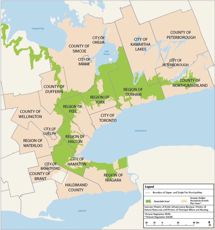
Figure 1: The Greater Golden Horseshoe (Source: Schedule 1, the Growth Plan for the Greater Golden Horseshoe, 2006).
The Growth Plan for the Greater Golden Horseshoe, 2006 aims to:
- Revitalize downtowns to become vibrant centres;
- Create complete communities that offer more options for living, working, shopping and playing;
- Provide greater choice in housing types to meet the needs of people at all stages of life;
- Curb sprawl and protect farmland and green spaces; and
- Reduce traffic gridlock by improving access to a greater range of transportation choices
The Built Boundary and the Growth Plan for the Greater Golden Horseshoe
This paper outlines the methodology to delineate the built boundary, and provides maps of the built boundary for each single- and upper-tier municipality in the Greater Golden Horseshoe for use in implementing the Growth Plan for the Greater Golden Horseshoe, 2006.
The Growth Plan for the Greater Golden Horseshoe, 2006 supports the creation of compact, mixed-use and transit-supportive communities. It requires municipalities to accommodate a significant portion of future residential and employment growth through intensification.
Intensification is the development of a property, site or area at a higher density than currently exists through:
- redevelopment, including the reuse of brownfield sites;
- the development of vacant and/or underutilized lots within previously developed areas;
- infill development; or
- the expansion or conversion of existing buildings.
Intensification yields many benefits, such as:
- revitalizing neighbourhoods and downtowns;
- making more efficient use of existing infrastructure;
- supporting more frequent transit service;
- reducing development pressures on valuable agricultural lands and important natural spaces; and
- providing a wider range of housing choices closer to amenities such as shopping and schools, which in turn increases convenience and reduces the amount of time spent traveling between destinations.
Figures 2a and 2b illustrate the transformation of a hypothetical site in a downtown through intensification. Through the addition of a few mid- and low-rise buildings on vacant sites, and pedestrian-oriented landscaping and paving, the neighbourhood depicted below is revitalized and transformed into a more vibrant and complete community.
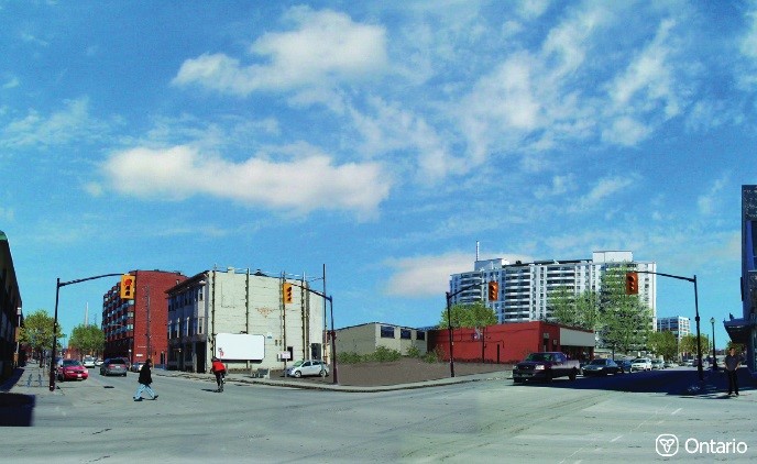
Figure 2a: Before.
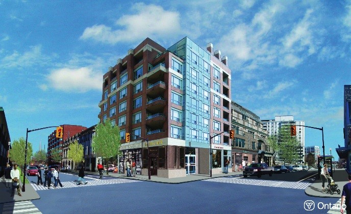
Figure 2b: After.
A key policy in the Growth Plan is the establishment of an intensification target, which specifies that by 2015 and each year thereafter, a minimum of 40 per cent of new residential development will occur within the built-up areas of each upper- or single-tier municipality [Growth Plan Policy 2.2.3.1]. The intensification target is a minimum target and municipalities are encouraged to plan for higher densities in built-up areas. Municipalities, through their intensification strategies, will identify areas appropriate for intensification within their built boundary.
Built-up areas are defined as the lands within the built boundary. They are those parts of a community's settlement area that are already developed.
Figure 3 below illustrates the Growth Plan definitions and terminology relevant to the built boundary.
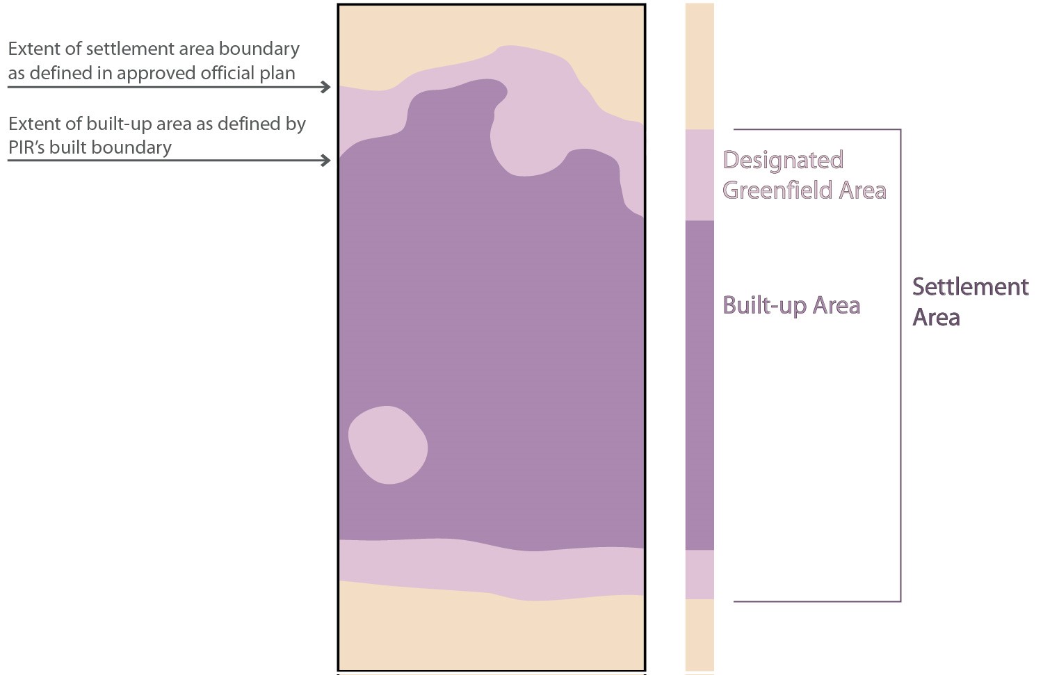
Figure 3: Terminology relevant to the built boundary.
The built boundary identifies the built-up area as of June 16, 2006, which is the effective date of the Growth Plan. The built boundary is fixed in time for the purposes of implementing and monitoring a number of key policies of the Growth Plan. Residential development occurring within the built boundary will be counted towards achievement of the intensification target. Lands that lie outside the built boundary but that are within the settlement area are subject to the Growth Plan's designated greenfield area policies, including the designated greenfield area density target. The settlement area boundary is defined by the respective municipal official plan. The Growth Plan's minimum density target for designated greenfield areas will be measured over the entire designated greenfield area of each upper- or single-tier municipality, and not on individual plans of subdivision.
The Province and municipalities will be able to measure the achievement of the Growth Plan's intensification and designated greenfield area policies, assess municipal land needs, as well as monitor the implementation and effectiveness of the objectives of the Growth Plan in building more complete, transit-supportive, vibrant and diverse communities and maximizing the use of existing infrastructure.
It is important to emphasize that the built boundary is not a land-use designation and the delineation of the built boundary will not confer any new land-use designations, nor alter existing land-use designations. Any development on lands within the built boundary is still subject to the relevant provincial and municipal land-use planning policies and approval processes.
The inclusion of lands within the built boundary does not necessarily mean that these lands will be developed or built upon. For example, the inclusion of a municipal park that is in its final form and within the built-up area does not imply that it will be redeveloped. Similarly, existing stable neighbourhoods within the built-up area might not be a focus for intensification.
Developing the Built Boundary for the Greater Golden Horseshoe
The Growth Plan defines the built boundary as "the limits of the developed urban area as defined by the Minister of Public Infrastructure Renewal in accordance with Policy 2.2.3.5". Policy 2.2.3.5 of the Growth Plan states that the Minister, in consultation with affected municipalities will verify and delineate the built boundary.
Between 2005-2007, the Ministry of Public Infrastructure Renewal reviewed existing methodologies and available data sources, and developed an innovative methodology to verify and delineate the built boundary for the Greater Golden Horseshoe. A summary of this review is included in Appendix 4 of this paper.
In November 2006, the Ministry of Public Infrastructure Renewal released the Technical Paper on a Proposed Methodology for Developing a Built Boundary for the Greater Golden Horseshoe which described four proposed steps to delineate the built boundary. The Ministry received numerous submissions and comments on the proposed methodology. Based on the input received, the methodology was finalized.
In late 2006, a preliminary draft built boundary was derived using data from the Ontario Parcel Alliance (OPA), the Municipal Property Assessment Corporation (MPAC) and datasets maintained by Land Information Ontario. The Ministry of Public Infrastructure Renewal verified this preliminary draft version of the built boundary, the underlying data and assumptions with all municipalities in the Greater Golden Horseshoe in the winter and spring of 2007.
Feedback and advice from municipalities based on their local, expert knowledge, was used to delineate a proposed final built boundary. In November 2007, the Ministry of Public Infrastructure Renewal released a technical paper titled Proposed Final Built Boundary for the Growth Plan for the Greater Golden Horseshoe, 2006 which contained the final methodology and maps of the proposed final built boundary. Suggested refinements and corrections to the mapping, proposed by municipalities and stakeholders, were reviewed and used to finalize the built boundary contained in this document.
This paper contains the full methodology to delineate the built boundary, and provides maps of the built boundary for each single- and upper-tier municipality in the Greater Golden Horseshoe for use in implementing the Growth Plan for the Greater Golden Horseshoe, 2006.
A PDF copy of this paper and the maps are available on the Places to Grow website at www.placestogrow.ca. The built boundary is also available in geographic information system (GIS) format from the Ministry upon request and is subject to an end-user license agreement with the Ministry.