Ministry review of the Scarborough waterfront project environmental assessment
Read our evaluation of the environmental assessment for a proposed system of parks on the Lake Ontario shoreline between Bluffer’s Park and East Point Park.
Environmental Assessment Act, R.S.O. 1990, subsection 7(1)
This review is subject to the provisions of Ontario Regulation 616/98 which sets out a deadline for the completion of this document. This paragraph and the giving of the notice of completion are the notices required by subsection 7(3) of the Environmental Assessment Act.
The review documents the ministry’s evaluation of the environmental assessment and takes the comments of the government agencies, the public and Indigenous communities into consideration.
Summary of our review
Who
Toronto and Region Conservation Authority (TRCA)
What
The TRCA is proposing the creation of a system of connected greenspaces, improved pedestrian and cyclist access to the waterfront, terrestrial and aquatic habitat enhancement, and provision of a safe and enjoyable waterfront experience by undertaking erosion protection measures along the Scarborough Waterfront.
When
EA submitted: June 15, 2018
EA comment period (7 weeks): June 15–August 3, 2018
Amendments to the EA submitted: September 4, 2018
The construction period for the project is approximately 12 years. The construction activities will not be in any one location for the entire time
Where
An 11 kilometre portion of the Lake Ontario shoreline from Bluffer’s Park east to East Point Park/Highland Creek, in the City of Toronto.
Why
The project is being proposed to improve access to the waterfront, address safety and erosion, and provide opportunities for habitat enhancements. This is consistent with and supports the objectives of other City of Toronto plans and guidelines such as the 1967 Waterfront Plan for the Metropolitan Toronto Planning Area and the 1996 Integrated Shoreline Management Plan for the shoreline between Tommy Thompson Park and Frenchman’s Bay. These plans introduced a shoreline management approach to limit shoreline erosion and to create a system of connected greenspaces and parks along the Toronto waterfront.
Conclusions
The ministry review concludes that the environmental assessment (EA) was prepared in accordance with the approved terms of reference (ToR) and contains sufficient information to assess the potential environmental effects of the proponent’s undertaking. The EA demonstrated that the TRCA will be able to meet the objectives set out in its ToR.
Conditions of approval are recommended to ensure additional consultation during the project’s detailed design phase.
1. Environmental assessment process
The Environmental Assessment Act (EAA) provides a proponent driven planning process designed to incorporate the consideration of the environment into decision-making by assessing the effects of an undertaking on the environment. In Ontario, the EAA sets out the general requirements for the preparation of an environmental assessment (EA), as well as the Ministry of the Environment, Conservation and Parks’ (MECP/ministry) evaluation process. For those proponents and undertakings subject to the EAA, approval under the EAA is required before the undertaking can proceed.
Proponents address a wide range of potential effects on the natural, social, cultural and economic environments to ensure the protection, conservation and wise management of the environment. An EA determines, on the basis of the environmental effects, if an undertaking should proceed, and if so, how environmental effects can be managed.
EAs may identify a problem or opportunity, consider alternative ways of addressing the problem or opportunity, evaluate the environmental effects of the alternatives and select a preferred undertaking from the alternatives. The proponent must consider actions to avoid, reduce and mitigate potential environmental effects as well as the advantages and disadvantages of the undertaking. In preparing the EA, the proponent completes various studies and consults with interested stakeholders including government agencies, the public and affected Indigenous communities to evaluate the alternatives and determine the preferred undertaking. If the undertaking is approved, the proponent is required to monitor to demonstrate compliance with standards, regulations and guidelines of the EAA approval.
1.1 Terms of reference
Completing the EA process involves two separate steps—the terms of reference (ToR) and the EA. The first step requires the proponent to prepare and submit a ToR to MECP for review and a decision. The ToR is the work plan or framework for how the EA will be prepared.
The ToR provided for a focussed EA pursuant to sections 6(2)(c) and 6.1(3) of the EAA. This allowed the proponent to focus the assessment in the EA on providing a process to identify and assess alternative designs and locations (alternative methods) for waterfront improvements. These improvements are intended to address the problems/opportunities or the project objectives identified by the Toronto and Region Conservation Authority (TRCA/proponent) in the ToR (e.g. risks from erosion, public access to the waterfront, opportunities for habitat enhancement, etc.).
On December 15, 2015, the former Minister of the Environment and Climate Change approved TRCA’s ToR. The ToR established the framework for the preparation of the EA, including:
- describing the purpose and the rationale for the undertaking
- identifying and evaluating potential environmental effects (both positive and negative)
- proposing mitigation measures as well as a consultation plan for obtaining input from the public, government agencies and Indigenous communities during the preparation of the EA
1.2 Environmental assessment
Once the ToR is approved by the Minister, the proponent can proceed to the second step of the process and carry out the EA. The EA must be prepared in accordance with the approved ToR and the requirements of the EAA. Once the proponent has completed the EA, including consultation, the EA is submitted to the ministry for review and a decision.
A draft EA was made available to the public and agencies between August 17, 2017 and October 2, 2017. On June 15, 2018, the proponent submitted the Scarborough waterfront project to the ministry for a decision on the proposed undertaking. The EA submission comment period ended on August 3, 2018.
The EA was circulated for review to a Government Review Team (GRT). The GRT included federal, provincial and local agencies, who reviewed the EA to ensure that the information and conclusions of the EA were valid, based on their agencies’ mandates. The public and Indigenous communities also had an opportunity to review the EA and submit their comments to the ministry. All comments received by the ministry are considered by the Minister before a decision is made about the undertaking.
The EA was amended on September 4, 2018 to address the outstanding concerns of the ministry and the Ministry of Natural Resources and Forestry (MNRF). The ministry’s Source Protection Programs Branch, Indigenous Consultation Advisor and Environmental Assessment Services Section had comments regarding the mitigation measures proposed to address impacts to highly vulnerable aquifers and protect drinking water sources, the completion of the Indigenous consultation record, and the residual effects associated with each alternative. MNRF had concerns regarding fish habitat and construction timing, and wanted a commitment from TRCA to work with MNRF during detailed design to ensure that shoreline works are appropriate and that subsequent approvals and permits can be obtained. The TRCA amended the EA to address these comments. The ministry and MNRF are satisfied with the amended EA and have no further outstanding comments.
1.3 Ministry review
The EAA requires the ministry to prepare a review of the EA, known simply as the ministry review (review). The review is the ministry’s evaluation of the EA and any amendments thereto. The purpose of the review is to determine if the EA has been prepared in accordance with the approved ToR and meets the requirements of the EAA, and whether the evaluation in the EA is sufficient to allow the Minister to make a decision about the proposed undertaking.
A notice of completion of the review was issued indicating that this review has been completed and is available for a five-week comment period. Copies of the review have been placed in the same public record locations where the EA was available, and copies have been distributed to the GRT members and potentially affected or interested Indigenous communities. Those members of the public who submitted comments during the EA comment period have also received copies of the review.
2. The proposed undertaking
Historical context
The “Waterfront Plan for the Metropolitan Toronto Planning Area“ (1967) introduced a shoreline management approach to limit shoreline erosion while creating a number of large parkland areas and public marinas connected by a waterfront trail system. In 1971, TRCA was designated by the province as the lead implementing agency for the Etobicoke to Ajax shoreline, which led to the creation of waterfront plans based on an integrated shoreline management approach. In 1992, the Royal Commission on the Future of the Toronto Waterfront (Royal Commission) released its final report entitled “Regeneration: Toronto Waterfront and the Sustainable City“, which outlined the lack of a coordinated, ecosystem approach to shoreline regeneration. The Royal Commission recommended that a shoreline regeneration plan be prepared to protect and regenerate the Lake Ontario shoreline from the City of Burlington in the west to the community of Newcastle in the east.
To implement this recommendation, the Ontario Government established the Waterfront Regeneration Trust in June of 1992, who initiated the creation of a Shoreline Management Strategy for the Lake Ontario shoreline from Burlington Bay to the Trent River. The Shoreline Management Strategy became a component of the overall “Lake Ontario Greenway Strategy“ released by the Waterfront Regeneration Trust in May 1995.
The “Lake Ontario Greenway Strategy“ (1995) recommended that Integrated Shoreline Management Plans be developed to provide a framework for future development and management of the Lake Ontario shoreline. Based on the traditional shoreline hazard management activities undertaken by Conservation Authorities, Integrated Shoreline Management Plans are intended to be more comprehensive in their scope, addressing the need to limit high rates of erosion, while enabling safe public access, and the creation of regional scale parkland and waterfront recreation opportunities. The Integrated Shoreline Management Plan for the section of shoreline between Tommy Thompson Park and Frenchman’s Bay was released in 1996. The plan provided the strategic direction for TRCA to develop the Scarborough Waterfront Project.
Since 1996, TRCA has been undertaking ongoing work to fulfill the strategic direction of the plan, including addressing areas of highest risk to loss of life and property due to erosion through the South Marine Drive Erosion Projection, Meadowcliffe Drive and Sylvan Avenue erosion control projects. In addition, a number of recent studies have further identified opportunities to enhance terrestrial and aquatic environments and public access along this length of shoreline, including a Terrestrial Biological Inventory and Assessment for the Scarborough Shoreline (2012), an Urban Recreational Fisheries Plan (2014) and the Bikeway Trails Implementation Plan (2012).
Study area and purpose
Study area
The project study area extends approximately 11 kilometres along the Lake Ontario shoreline, from Bluffer’s Park in the west to the mouth of Highland Creek in the east, north to Kingston Road/Lawrence Avenue, and to a maximum of one kilometre offshore. Please refer to Figure 1 for a map of the area. Included in the project study area is the following:
- the Bluffs, which rise approximately 90 metres from the water, and include both the top and bottom of the Bluffs
- Great Lakes Waterfront Trail which runs along the top of the Bluffs and through residential neighbourhoods
- access routes to the shoreline: Brimley Road (only road access), Doris McCarthy Trail (formal existing pedestrian access), and Guild construction access route and Beechgrove Drive (informal existing pedestrian access points)
- existing formal trails and informal trails along the top and bottom of the Bluffs due to the discontinuous access to and along the shoreline
- parks and ravines (from west to east): Scarborough Crescent Park, Bluffer’s Park, Brimley Road Ravine, Sunny Point Ravine, Broadmead Valley, Cathedral Bluffs Park, Cudia Park, Meadowcliffe Valley, Bellamy Ravine, Sylvan Park/Gates Gully, South Marine Drive Park, Guild Park and Gardens, Grey Abbey Park, Grey Abbey Ravine, Easterly Filtration Plant Ravine, Beechgrove Ravine and East Point Park
- Metrolinx Lakeshore East and Canadian National Railway corridor right-of-way and railway running east west on top of the Bluffs, south of Kingston Road
- three Areas of Natural and Scientific Interest (ANSI) and five Environmentally Significant Areas (ESAs) are dispersed throughout the entire study area
- existing shoreline is a mix of open coast with headland features, open coast with retaining wall features and non-engineered shoreline
The project’s shoreline is a combination of both public and privately owned land. Formalized public vehicle road access is currently restricted to the west portion of the project study area along Brimley Road and through Bluffer’s Park, which includes the Bluffer’s Park marina and Bluffer’s Park Beach and parking area. Formal public access stops at the end of Bluffer’s Park Beach. A narrow stretch of beach also exists in this section of the project study area below the Cudia Park Bluffs, immediately east of the Bluffer’s Park Beach. The lake often reaches the bottom of the bluffs through this short stretch, limiting pedestrian access along the shoreline.
A large portion of the remaining shoreline consists of an informal and unmaintained access route through the central portion of the project study area (the Guild construction access route) that is secured by existing shoreline protection works and is not formally open for public use; however, pedestrians often use it. In the east portion of the project study area, from Morna Avenue eastward, approximately 490 metres of the sand shoreline has been modified by private landowners and the City of Toronto. Access to this area is restricted as it is privately owned. While the shoreline below Grey Abbey Park is public land, it is inaccessible due to the private land to the west and east of Grey Abbey Ravine and restricted access around the F.J. Horgan Water Treatment Plant. The shoreline through East Point Park is informally accessible to the public, but does not accommodate access for people of all abilities.
The project study area consists of a mixture of neighbourhoods, parks, natural areas and open spaces. The City of Toronto’s Official Plan designates the bottom of the Bluffs, along the shoreline, as parks and natural areas. The top of the Bluffs consist of a mix of residential communities, businesses, parks, natural areas and other open space areas.
Purpose
The focus of the proposed project will be to address the remaining risks to public safety and public property and to link public spaces along the shoreline, both along the top and bottom of the Bluffs. The project will strategically identify areas that pose risks to public safety (fall, trip hazards) and public property (loss of property due to erosion), while integrating new public access (trails), recreational opportunities (trails, green spaces) and improvements to the natural habitat along the Scarborough Bluffs. The EA indicates that implementation of shoreline erosion protection is needed as the risk to people and roads/infrastructure is considerable. The EA identifies that over the next 60 years (the risk assessment timeframe for the project) roads/infrastructure are at risk of being destroyed and people are at risk of falling or having land fall on them, thus requiring protection in accordance with Provincial guidelines.
The objectives of the proposed project are to:
- protect and enhance terrestrial and aquatic natural features and linkages through approaches such as constructed wetlands and creating and linking natural terrestrial habitats
- manage public safety and property risk through improved access to the waterfront areas and continuing erosion control works
- provide an enjoyable waterfront experience through creating a diversity of experiences, including moving the Great Lakes Waterfront Trail down along the shoreline and making it a multi-use recreation trail
- provide consistency and coordination with other initiatives and planning that has been conducted in this area including the Lake Ontario Greenway Strategy, the Urban Fish Management Plan and the Guild Park and Gardens Management Plan
- achieve value for cost through maximizing benefits achieved in relation to the estimated project cost
Description of the proposed undertaking
The project study area is divided into three segments:
- west segment (Bluffer’s Park to Meadowcliffe)
- central segment (Meadowcliffe to Grey Abbey)
- east segment (Grey Abbey to East Point Park/Highland Creek)
The project study area refers to the area along the shoreline, including both the top and bottom of the Bluffs and the identified access routes.
The key components of the proposed undertaking include:
- moving the Great Lakes Waterfront Trail down along the shoreline and making it a continuous multi-use trail
- improved pedestrian access from the top of the Bluffs to the waterfront
- changes to the shoreline to provide erosion control and to increase aquatic and terrestrial habitat
West segment
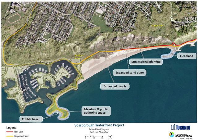
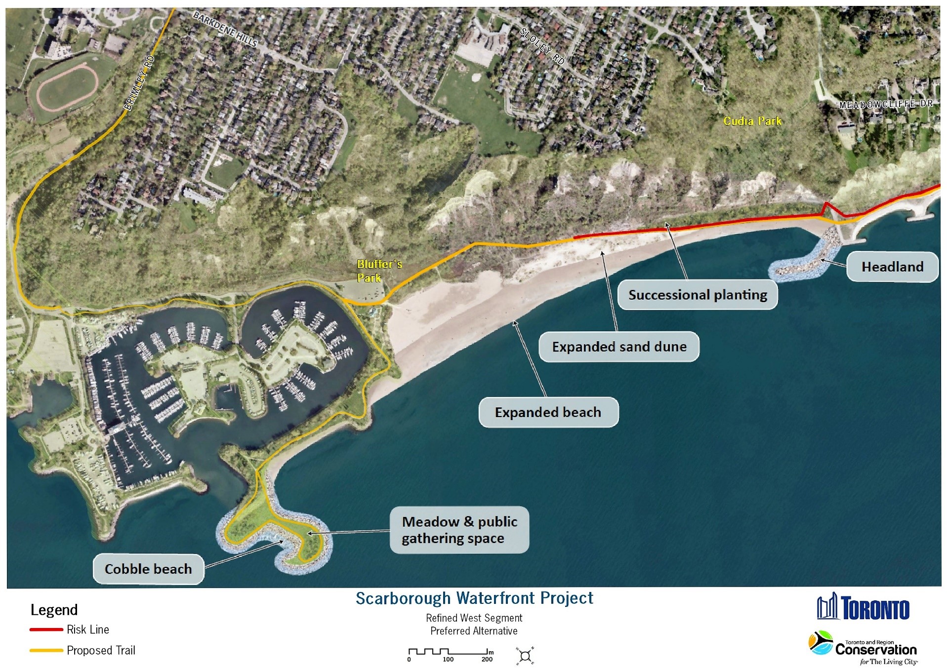
The west segment will consist of an extension to the existing headland at the west end, near Bluffer’s Park, by approximately 230 metres into Lake Ontario. The altered headland will include a small cobble beach to provide access to the water and to enhance fish habitat. The existing armourstone headland at the east end of the segment will be extended by approximately 200 metres into Lake Ontario. Bluffer’s Park Beach will expand approximately 400 metres in length and 60 metres in depth which will close the gap along the shoreline below Cudia Park, provide a continuous connection between the west and central segments of the study area and halt the erosion at the base of Cudia Park. This will be facilitated through the implementation of a raised berm with cobble and sand placed in front (lakeside), which will be kept in place by a temporary low wall (groyne). Placement of the raised berm will be positioned approximately 30 metres from the Bluffs to allow safe public access, outside of the erosion hazard risk area, into the central segment. The longer, more irregular shoreline of the expanded headlands and the addition of larger material, such as cobbles or boulders, will enhance aquatic habitat (e.g. fish habitat). A new multi-use trail on the east side of Brimley Road will be constructed to provide safe pedestrian and cyclist access to the shoreline. The proposed new multi-use trail will connect with the existing pedestrian trail at the bottom of the Bluffs and will extended eastward along the shoreline through the segment. Please refer to Figure 2 for a detailed map of the west segment.
Central segment
At the base of the Doris McCarthy Trail, near the west end of this segment, a new headland beach system, with two new headlands and the extension of an existing headland, will be constructed into Lake Ontario. The new headland beach system will be designed to provide a gathering space, reduce wave overtopping and provide safe access along the shoreline. Also, a veneer of rock and/or stone material will be applied on top of the existing shoreline to create a cleaner cover and provide suitable aquatic habitat. In the Guild Park and Gardens area, new headland features, with cobble beaches in-between, will address current aesthetic concerns by covering the existing exposed rebar along the shoreline. The maximum distance of the extension from the shoreline into the water will be 100 metres. Additionally, a new, approximately 130 metre-long headland will be constructed at the base of the existing Guild construction access route. The trail from the west segment will be carried through the central segment along the bottom of the Bluffs by improving the existing Guild construction access route. The existing shoreline access routes, Doris McCarthy Trail and Guild construction access route, will receive minimal improvements due to the significant negative impact on the natural environment. However, minor improvements will be made such as the addition of level rest areas which will consist of a hardened flat surface and may include benches. Please refer to Figure 3 for a detailed map of the central segment.
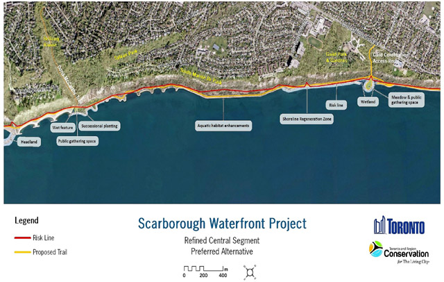
The EA indicates that while the existing rubble along the shoreline is protecting the bottom of the Bluffs, it does not provide long-term shoreline protection. The addition of the headland beach system will increase diversity of fish habitat and provide long-term shoreline protection.
East segment
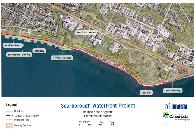
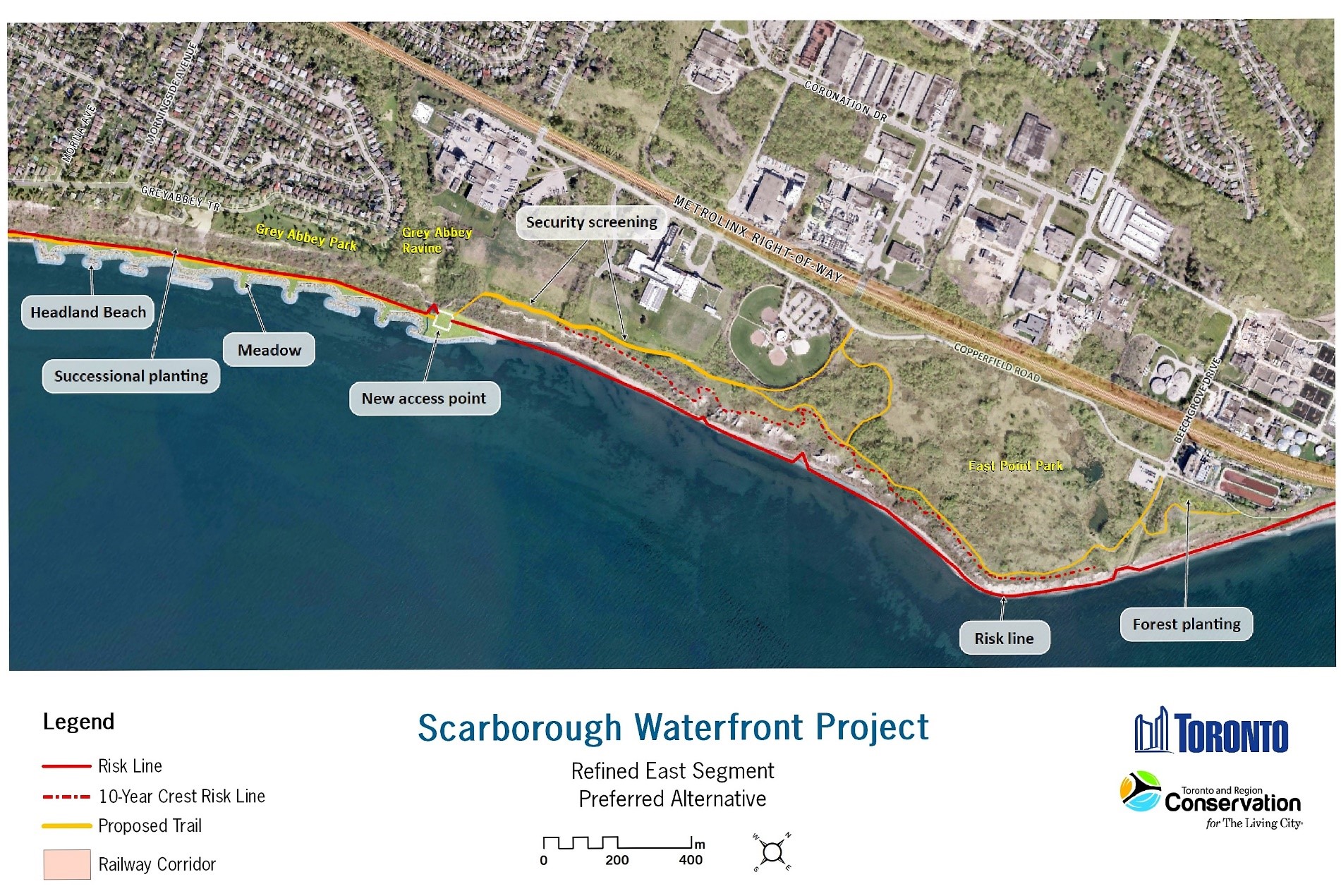
The east segment will consist of a headland beach system that extends from below Morna Avenue to the east side of the Grey Abbey Ravine. This will provide a continuous shoreline connection from the central segment to the eastern edge of the ravine, eliminating the current limited public access due to private property. The headlands will extend approximately 80 metres into Lake Ontario and will vary in length from approximately 40 to 100 metres, with the easternmost headland being approximately 180 metres. Between the headlands will be beaches and the beach cobble size will vary depending on the headland length and spacing. The headland beach system proposed below Grey Abbey Park will stop erosion at the base of the Bluffs and slow erosion at the top of the Bluffs, allowing the Bluffs to reach their stable slope. Access to the water will be facilitated through the cobble beaches of the headland beach system, which will have a gradual slope down to the water’s edge.
Near the bottom of the Grey Abbey Ravine, a structure will extend upwards to provide access and connect the shoreline trail with a new trail that will run along the top of the Bluffs to connect with East Point Park. Please refer to Figure 4 for a detailed map of the east segment.
Construction timing and cost
Construction is expected to begin following all necessary permits and approvals. Construction of the proposed project would cost approximately $170 million and require acquisition of approximately 28 hectares of water lots and approximately 14 hectares of private property. Construction is predicted to last approximately 12 years and be built out in three phases as per the three segments. The first phase will be the west segment, followed by the central segment, ending with the east segment.
If EAA approval is granted, the undertaking will be completed in accordance with the terms and provisions outlined in the amended EA, any proposed conditions of approval and will include the details outlined above. In addition, TRCA must still obtain all other legislative approvals it may require for the undertaking.
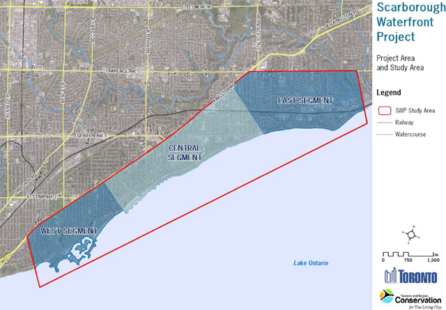
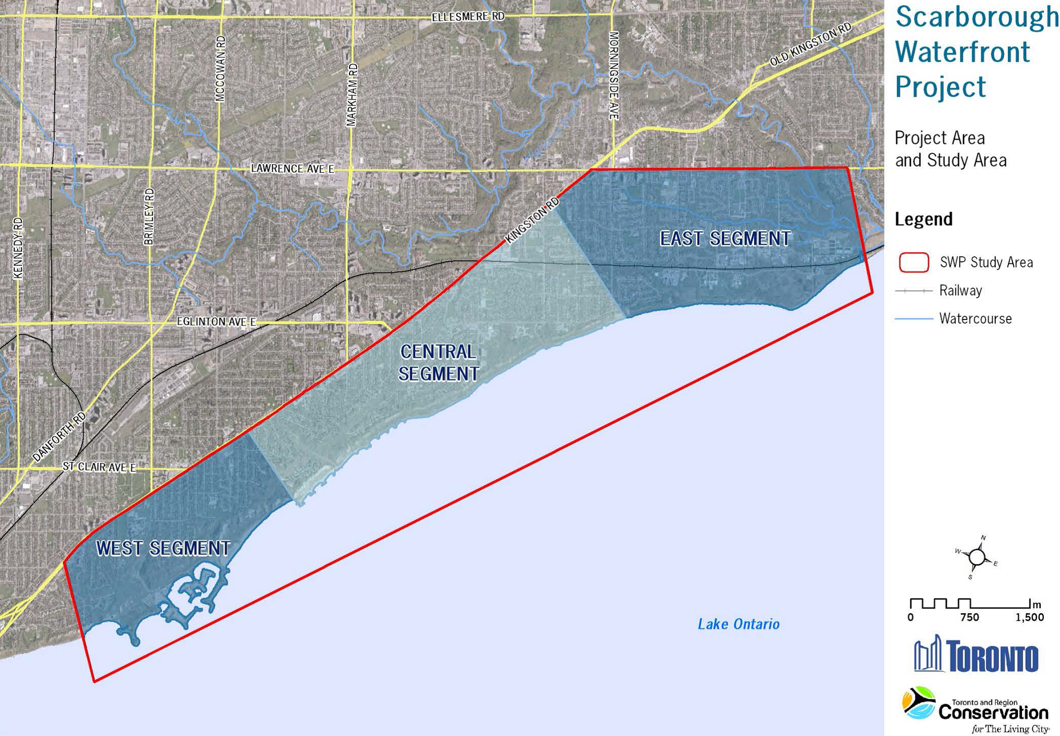
Figure 1: Project location/study area
View a larger version of this map (JPEG)
This figure shows the Scarborough waterfront project study area, specifically from Kingston Road south to Lake Ontario and from Midland Avenue east to Port Union Road.
This figure also highlights three segments within the study area:
- west segment (from Bluffer’s Park to Meadowcliffe Drive)
- central segment (from Meadowcliffe Drive to Grey Abbey)
- east segment (from Grey Abbey to East Point Park/Highland Creek)
Figure 2: Preferred alternative—west segment
View a larger version of this map (JPEG)
This figure depicts the preferred alternative for the west segment. This includes a proposed multi-use trail along Brimley Road down to the waterfront and along the shoreline towards the central segment.
This figure also depicts two headland features: one with a cobble beach, meadow and gathering space at the mouth of the Bluffer’s Park Marina and the other with armourstone at the east end of the segment. Between the two headlands, Bluffer’s Beach will be expanded in length and depth which allows for the multi-use trail to run along the base of the Bluffs.
Figure 3: Preferred alternative—central segment
View a larger version of this map (JPEG)
This figure depicts the preferred alternative for the central segment. This includes a multi-use trail along the shoreline through the entire segment and improvements to the Doris McCarthy Trail and the Guild construction access route which provide access down to the waterfront.
This figure also depicts shoreline works which consist of headlands and beaches in the west end of the segment, two public gathering spaces at the base of the Doris McCarthy Trial and the Guild construction access route, and updates to the existing shoreline materials.
Figure 4: Preferred alternative—east segment
View a larger version of this map (JPEG)
This figure depicts the preferred alternative for the east segment. This includes a multi-use trail along the shoreline to Grey Abbey Ravine where a structure will be built to extend upwards to provide access and connect the trail with a new trail that will run along the top of the Bluffs and connect with East Point Park.
This figure also depicts shoreline works at the base of Grey Abbey Park which include a headland and beach system.
3. Results of the ministry review
The review provides the analysis of the EA. The review is not intended to summarize the EA, nor present the information found in the EA. For information on the decision making process, refer to the EA itself. The EA and supporting documentation outlines the EA planning process and demonstrates how the proponent has selected the preferred undertaking and made the final decision.
3.1 Conformance with ToR and EAA
3.1.1 Ministry analysis
The ministry coordinated an analysis of the EA with the Government Review Team (GRT) that, in part, looked at whether the requirements of the ToR have been met. The ministry has concluded the amended EA followed the framework outlined in the ToR, and has addressed the commitments made in the ToR.
Appendix A summarizes this analysis and identifies how the ToR requirements have been addressed in the amended EA. Conditions of approval may be proposed to ensure continued consultation, as described in Section 3.3 of this review.
3.1.2 Consultation
One of the key requirements of the EAA is pre-submission consultation completed during the preparation of the EA. This consultation is the responsibility of the proponent and must be taken prior to the submission of the EA to the ministry and must be in accordance with the consultation plan outlined in the ToR.
Government Review Team
Consultation with the GRT was conducted throughout the EA process. This included:
- pre-submission discussions
- technical meetings with ministry staff
- one meeting with the Technical Advisory Committee which was disbanded in favour of individual meetings
- meetings with two agency working groups (Aquatic Habitat Toronto and the Bank Swallow Working Group)
- meetings with key members of the GRT
- providing an opportunity to review the draft EA
Many of the comments provided on the draft EA were incorporated into the final EA which was submitted to the ministry.
The MNRF, Ministry of Tourism, Culture and Sport (MTCS), MECP and City of Toronto all provided comments throughout the EA process and on the draft EA. MNRF comments on the draft EA included protecting natural heritage features, minimizing loss of areas designated as ANSIs, maintaining a natural erosion/deposition of Lake Ontario, ensuring Species-at-Risk are addressed appropriately, and the need for further discussions between MNRF and TRCA. TRCA committed to working with MNRF during detailed design to address these comments. MTCS indicated that it was satisfied with TRCA conducting the Stage 2 Archaeological Assessment during detailed design. TRCA updated the EA documentation to reflect this. MECP and City of Toronto comments covered a multitude of topics, ranging from what permits may be required to additional descriptions of the alternatives considered, and can be found in Appendix L of the EA. TRCA amended the EA to address some of the comments.
Comments from MNRF, MECP and the City of Toronto were received during the EA submission comment period. MECP and MNRF are satisfied that the amended EA addresses the comments made. Refer to Section 3.3 of this review or Appendix B for discussion on these comments.
Public consultation
The proponent used a variety of consultation methods to consult with the public including:
- public notices
- three public information centres
- a Stakeholder Committee consisting of 20 key interest groups
- direct community engagement
- individual stakeholder meetings
- online engagement
The notice of commencement for the undertaking was issued on January 7, 2016. The proponent made the draft EA and its supporting documents available on the project website to members of the public for comment from August 17, 2017 to October 2, 2017. A notice of submission for the draft EA was published in the Scarborough Mirror and distributed to local businesses and households within the study area via mail and social media. The proponent received 112 comments from members of the public on the draft EA report. Comments were made with respect to the following themes: access, beach, marina, climate change, construction, consultation, erosion, alternative options, safety, aquatic habitat and water quality. A summary of participant feedback, included in Appendix L of the EA, outlines concerns raised and the proponents’ responses. The final EA and consultation record was revised to address the public input received on the draft EA.
The notice of submission of the final EA was published on June 15, 2018 in the Scarborough Mirror and distributed to the GRT, Indigenous communities and members of the public who had provided comments on the draft EA. The ministry received 33 comments from five community organizations, one company and the general public. These comments largely mirrored comments on the draft EA with respect to the selection of the preferred alternative, its cost and its effects to the environment being the most prominent concerns. Refer to Section 3.3 of this review for a discussion of these comments.
Indigenous community consultation
In addition to the EAA requirement that interested persons be consulted, proponents are required to consult with Indigenous communities who have credibly asserted or established Aboriginal or treaty rights that may potentially be negatively impacted by the proposed undertaking.
The proponent developed a list of potentially impacted Indigenous communities and provided them with information on the EA throughout the process. The list of Indigenous communities that were contacted included:
- Beausoleil First Nation
- Chippewas of Georgina Island First Nation
- Chippewas of Rama-Mnjikaning First Nation
- Conseil de la Nation Huronne-Wendat
- Curve Lake First Nation
- Haudenosaunee Confederacy Chiefs Council c/o Haudenosaunee Development Institute
- Hiawatha First Nation
- Kawartha Nishnawbe First Nation
- Métis Nation of Ontario
- Mississaugas of Alderville First nation
- Mississaugas of the New Credit First Nation
- Mississaugas of Scugog Island First Nation
- Six Nations of the Grand River
- Williams Treaties First Nation Claims Coordinator
The list was developed in consultation with the ministry, searching the Aboriginal and Treaty Rights Information System, contacting the Ministry of Indigenous Affairs and through community contacts lists from the City of Toronto.
Formal study notices were circulated to Indigenous communities. Correspondence invited the communities to participate during the ToR phase of the study and each round of EA consultation. Meetings took place with Curve Lake First Nation and the Mississaugas of the New Credit First Nation. During preparation of the EA, the above listed communities were kept informed of the progress of the EA and received a copy of the draft EA to review and provide comments on. The following is a summary of the comments submitted by Indigenous communities during the preparation of the EA.
The Conseil de la Nation Huronne-Wendat, Chippewas of Georgina Island First Nation and Mississaugas of the New Credit First Nation corresponded with the proponent and advised that they had an interest in the archaeological works being completed for the project. The Mississaugas of the New Credit First Nation advised that it would like to have monitors on site for all environmental and archaeological assessments. The proponent has committed to continue to engage with the community during detailed design, providing updates on additional archaeological work.
Curve Lake First Nation, the Mississaugas of the New Credit First Nation and Hiawatha First Nation raised concerns with respect to the protection of the water and water sources with fish habitat and/or spawning areas as well as the potential impacts to aquatic and terrestrial life during the construction period. The proponent has committed to continue to engage with the community during the detailed design phase in this regard.
The Conseil de la Nation Huronne-Wendat and the Mississaugas of Scugog Island First Nation asked the proponent to consider including historical information sites within the project study area and educating the public on the history of the lakefront from the First Nation perspective respectively. The proponent has committed to continue to engage with these communities during detailed design phase with respect to including historical/commemorative sites and incorporation of public education pieces.
Comments from Curve Lake First Nation were received during the EA submission comment period. No other Indigenous communities submitted comments on the final EA. Refer to Section 3.3 of this review for discussion of these comments.
3.1.3 Conclusion
The EAA requires that the proponent consult with all interested persons during the preparation of the EA and report on the results of that consultation. The EA adequately describes the consultation that was undertaken and the outcomes of the various consultation activities/events. The EA documents how input received throughout the consultation program influenced the study, and ultimately the preferred alternative. The proponent has undertaken a fulsome consultation program as part of the EA.
The ministry is satisfied that the level of consultation undertaken with the public, Indigenous communities and GRT was appropriate for this proposed undertaking.
Overall, the ministry believes that the proponent provided sufficient opportunities for the public, interested stakeholders, government agencies and Indigenous communities to be consulted during the preparation and finalization of the EA. The proponent has committed to continue to engage Indigenous communities, interested stakeholder groups and agencies during detailed design and construction phases of the proposed undertaking.
The ministry is satisfied that the consultation undertaken is consistent with the Code of Practice for Consultation in Ontario’s EA Process and best practices, meets the requirements of the EAA, and is consistent with the approved ToR.
3.2 EA process
In accordance with the approved ToR, the EA included a description of the purpose and rationale for the undertaking in Chapter 2 of the EA as well as a description of the existing environment in Chapter 3 of the EA considering the broad environment as required under the EAA. The existing environment was separated into three categories: physical environment, natural environment and socio-economic environment. Each of the three categories contained sub-categories such as hydrogeology, surface water quality, coastal processes, shoreline and Bluff erosion, terrestrial habitat, aquatic habitat, species at risk, land use, population and demographics, access, traditional use, and cultural heritage.
Alternatives assessment
A framework for the identification, rationale and evaluation of alternative methods was developed and used by the proponent in accordance with the ToR. The alternatives selection was broken down into several steps in Chapter 5 of the EA. For an analysis of the alternatives assessment please refer to Appendix A.
The following steps were performed separately for each shoreline segment and the proposed alternatives were only compared with other alternatives within the same segment. This was done to simplify the comparison of alternatives and address segment-specific problems. Eight alternatives were considered for the west segment, two for the central segment, and nine for the east segment. The alternative methods differ by design and trail position, and in the east segment, location. The Do Nothing alternative was also considered for each segment.
- The first step in the development of alternatives was the consideration of existing physical, natural and socio-economic conditions in the study area. As part of this step, a bottom-of-slope risk line and top-of-bluffs erosion hazard limit was identified, which indicated the lines beyond which public safety risks have been adequately mitigated, but not eliminated. These lines are calculated on the basis of MNRF's technical guidelines, geotechnical engineering criteria, observation and professional judgement.
- For each segment the problems (limited access to and along the waterfront, erosion and risk to public safety and property, and habitat integrity) and opportunities for improvement (reduce the risk to public safety and property and provide a continuous trail along the shoreline) were identified.
- Considering the baseline conditions, the risk line and erosion hazard limit, and identified problems/opportunities, a range of shoreline protection options were identified for each segment that would accommodate safe public access beyond the risk line/ erosion hazard limit and stop erosion. As part of this process, existing shoreline protection works were also evaluated for need of maintenance, repair or retrofit.
- Following the development of shoreline protection options, access improvement options along the waterfront were considered through trail routing, with the goal of re-aligning the current Great Lakes Waterfront Trail (multi-use trail) into public ownership along the shoreline, where possible.
- With all of the above in mind, each segment alternative and the preferred undertaking was individually assessed using the five objectives of the project. Refer to the Purpose section of this review for an outline of the project objectives.
In order to determine the preferred alternative for each segment, a logical and easy to follow comparative assessment was completed. The preferred alternative was subsequently refined through further public, government agency and other stakeholder consultation.
Evaluation of environmental effects and the undertaking
All segment alternatives and the preferred undertaking were comparatively assessed for each of the five project objectives using environmental criteria and indicators. In accordance with the ToR, the criteria and indicators were used to identify and assess environmental effects of the various alternatives and the preferred undertaking including net effects (effects remaining after mitigation is applied; refer to amended Chapters 5 and 7 of the EA). Criteria and indicators were developed in consultation with the public and other stakeholders. The ministry gained an understanding of the advantages and disadvantages of the proposed undertaking through the comparison provided in the EA of the other alternatives and the Do Nothing alternative. The EA also concluded that during construction that the project will not result in significant negative effects after the application of mitigation measures, such as providing construction activity timing windows to avoid effects and use of best management practices during construction for dust, emissions and noise.
The final preferred alternative was chosen as it best met the objectives for the project. This included for example:
- providing and enhancing natural heritage features—increasing terrestrial and wildlife habitat (e.g. fish habitat along the shoreline)
- public health and safety by providing long term erosion control improvements for the Bluffs and safe public access
- providing an enjoyable waterfront experience by increasing pedestrian access down to the shoreline and providing continuous pedestrian access along the shoreline
- consistency and coordination with other initiatives through adherence to other regulatory requirements and plans (e.g. City’s Official Plan and the Wet Weather Flow Master Plan, Accessibility for Ontarians with Disabilities Act, etc.)
- value for cost by providing operation and maintenance costs that were reasonable for the project
A description of the preferred alternative is provided in Chapter 6 of the EA.
Refer to Appendix A of this review for the ministry’s analysis of how the EA met the requirements of the EAA and the approved ToR.
Monitoring and commitments
In addition to the proposed compliance monitoring for the commitments in the EA and any potential conditions of approval, TRCA is proposing to monitor the baseline environmental conditions to identify any changes that may affect project outcomes as part of the detailed design. TRCA is also proposing to monitor environmental performance during operations. An adaptive environmental management approach will be undertaken for both monitoring approaches.
Table 8-1 in Chapter 8 of the amended EA outlines commitments to future work and consultation including environmental monitoring for the proposed undertaking.
3.2.1 Conclusion
Overall, the ministry, in consultation with the GRT, is satisfied with the proponent’s decision making process. The EA contains an explanation of the problem and previous studies that prompted the EA and the opportunities that can be realized as part the proposed undertaking. A reasonable range of alternatives and designs were considered for the project, consistent with the project objectives, and it is evident that public and government agency input was considered in the creation, evaluation and selection of these alternatives.
The EA provides a description of the potentially affected environment in the study area and identifies the potential effects of the alternatives. Net effects are identified in the amended EA and commitments to monitoring are made to ensure any potential negative effects from the undertaking are minimized.
The EA adequately described the advantages and disadvantages of the proposed undertaking to the environment based on potential residual environmental effects. Requirements of the EAA for consultation with the public, GRT and Indigenous communities have been met. The ministry is satisfied that the EA has been completed in accordance with the approved ToR and meets the requirements of the EAA.
3.3 Comments on the undertaking
3.3.1 Key issues
Issues and concerns from the GRT, public and Indigenous communities regarding the proposed undertaking were received by MECP during the review and comment period that followed the submission of the EA. All comments received, along with the responses provided by TRCA, are included in Tables 1, 2 and 3 in Appendix B of this review. This section summarizes the key issues that were raised during the EA process.
Government Review Team comments
Government agencies that provided comments on the EA submission include MECP, MNRF and the City of Toronto. For more information on the proponent’s responses to these comments and the ministry’s conclusions, please refer to Table 1 of Appendix B.
Ministry of Natural Resources and Forestry
MNRF had concerns regarding the sampling techniques and data provided on the fish community, timing windows for in-water works and the classification of Species at Risk. MNRF was also concerned with TRCA deferring important details, such as the land required and the amount of permanent infrastructure associated with the trail, to later stages of the project with no guarantee for on-going involvement, input and review from MNRF.
TRCA amended the EA and committed to continued consultation during detailed design with MNRF. A condition of approval is recommended to require TRCA to consult with MNRF during the detailed design phase. MNRF indicated that it is satisfied with the amended EA.
City of Toronto
The City of Toronto indicated that the City of Toronto Council’s decision on May 22, 2018, along with TRCA’s report, constitute the City of Toronto’s final comments. The City of Toronto Council endorsed the EA for submission to the ministry for review and a decision. The decision included a request for TRCA to: maximize, maintain and/or create new sandy shorelines, including a further review of key sand shorelines such as Grey Abbey; explore ways to protect existing wave conditions; and include public amenities such as accessible washroom facilities, all as part of the next stage of design and in keeping with the key project objectives and commitments of the EA.
TRCA understands that refinements to the east segment preferred alternative may be required due to the changes that may occur before construction in the east segment will begin, including the impact of Metrolinx’s Lakeshore East Rail Corridor expansion, the development of a Master Plan for East Point Park and additional erosion monitoring data. This additional information will assist in refining the east segment preferred alternative, consistent with the direction from the City of Toronto Council. TRCA has committed in the amended EA to on-going consultation with stakeholders in the east segment throughout the detailed design phase.
Public comments received by the ministry also referenced the City of Toronto Council’s decision.
TRCA has stated that if approval is obtained for the undertaking, it will continue to work with the public and other stakeholders and discuss refinements to project components in the east segment as additional information becomes available. A condition of approval is recommended as part of the Minister’s decision to require the proponent to continue to work with the City of Toronto and stakeholders to refine the east segment and look at ways to incorporate sandy shorelines consistent with the project’s objectives.
Public comments
A total of 33 interested persons provided comments to the ministry on the EA submission which include the following organizations:
- Lake Ontario Waterkeeper
- Save Grey Abbey Beach
- The Wild Bluffs
- Alliance to Protect Environmentally Sensitive Areas
- Toronto Natural Shorelines
For more information on the proponent’s responses to these comments and the ministry’s conclusions, please refer to Table 2 in Appendix B of the review.
Grey Abbey Park shoreline
The majority of public comments received by the ministry cited concerns with impacts to the Grey Abbey Park shoreline, located in the east segment of the project. The public would like the shoreline to be left untouched rather than reinforced with cobbles and boulders and are concerned that reinforcement of the shoreline will limit public and wildlife access to the water and destroy a natural sand beach. The public is also concerned with re-routing the current Great Lakes Waterfront Trail, which goes through the neighbourhood near the top of the Bluffs, to the shoreline.
The EA demonstrates that a range of alternatives were assessed for the east segment, which contains the Grey Abbey Park shoreline. Some of the alternatives included the “Do Nothing” alternative, which would leave the Grey Abbey Park shoreline as it is, a headland beach system with a multi-use trail along the shoreline to East Point Park, and a mixture of the headland beach system and bridges connecting the headlands. These alternatives did not meet the objectives of the project. Specifically, the EA indicates that the shoreline protection structures such as headlands and beaches consisting of boulders and cobble stone are required at the bottom of Grey Abbey Park as the roadway and associated infrastructure at the top of the Bluffs is at risk from erosion and there is currently no formal safe public access to the shoreline in this area.
Based on input from stakeholders during the EA process, the preferred alternative for the east segment, which includes Grey Abbey Park shoreline, was refined by the proponent. The EA indicates that the Grey Abbey Park shoreline will now include minimized headlands with smaller cobble beaches between them that are sloped. The smaller cobble stone size and slope to the land will allow for wildlife and the public to access water. The proposed works will also enhance the existing wildlife corridor by expanding the existing land base and creating fish habitat. As well, the proponent indicated that the preferred alternative for the sand shoreline at East Point Park, east of Grey Abbey Ravine, was refined through consultation and TRCA decided to leave the sand shoreline untouched.
The Grey Abbey Park shoreline is currently a mix of public and private land. While people are known to access the entire Grey Abbey shoreline, use of private land is considered trespassing. Through the EA process, TRCA has heard from private property owners that they do not want people trespassing over their property to continue. TRCA plans to acquire certain lands to create a continuous multi-use trail along the shoreline that will be accessible by the public.
The EA includes a proposed multi-use trail for the bottom of the Bluffs along the shoreline in this location. Due to the planned expansion of the nearby railway corridor, on the top of the Bluffs south of Kingston Road, there are safety concerns with leaving the current Great Lakes Waterfront Trail at the top of the Bluffs. In the EA, all of the alternatives that were assessed for the east segment, except for the Do Nothing alternative, placed the multi-use trail along the shoreline at Grey Abbey Park as being preferred.
The ministry recognizes that the public would like to maintain the sandy beach below Grey Abbey Park. However, TRCA determined that the loss of publically inaccessible sandy shoreline below Grey Abbey Park is offset by an increase in overall safe shoreline access. However, it is noted that TRCA will continue to work with stakeholders during the detailed design phase to determine and refine improvements to this area. A condition of approval is recommended to consider this issue.
The ministry is satisfied that the proponent met the requirements of the ToR and the objectives for the study as stated in the EA.
Access
Public comments received by the ministry indicate that residents are concerned that access to the shoreline and the water for people and wildlife will be limited or not available.
As part of the preferred alternative in the EA, two new access points will be formalized at the Guild and East Point Park, for a total of four access points to the waterfront (including Brimley Road and Doris McCarthy Trail). Access along Brimley Road will be improved through the implementation of a separated, multi-use path on the east side of the road, which will provide safe pedestrian and cyclist access away from vehicles down to Bluffer’s Park. In the west segment, continuous access will be provided along the water’s edge via a multi-use trail and a wider, longer beach (expansion by 400 metres in length and 60 metres in depth) allowing for increased direct access into the water. The headland near the marina will also allow for improved navigation conditions to the marina for boaters. Continuous access along the water’s edge in the central segment will also be provided via a multi-use trail. The addition of sloped cobble beaches as part of the new headland beach system will allow for increased access to the water and space for a lookout/gathering space. In the east segment, continuous access along the water’s edge via a multi-use trail which then transitions up to the top of the Bluffs and connects with existing trails.
No new roads or parking structures are proposed; however, public transit has increased service to the study area on a trial basis by adding a new bus service that runs from May to October from Kennedy Station to Bluffer’s Park Beach.
The proponent has indicated that formal public access along the shoreline will now be provided through areas that are currently constrained by private property and sloped cobble beaches between the headlands will allow for access to the water. While the project will result in a net loss in sand/gravel shoreline, the project, over all three segments, will provide an increase in overall beach (predominantly cobble) and a more accessible water’s edge, including improved opportunities for cycling and walking.
The ministry is satisfied that what is proposed meets the project objectives and that access will be available for wildlife and the public through the provision of new access points, the creation of a new multi-use trail, the development of an expanded sandy beach at Bluffer’s Park and sloped cobble beaches between the headlands. The ministry is also satisfied that the proponent met the requirements of the ToR.
Erosion control and public safety
Members of the public have called into question the nature of the risk to public property and safety from erosion, as well as the validity of shoreline hardening as a method to prevent erosion.
The proponent has advised that based on the determination of the erosion hazard limit/risk line and the alternatives assessment for all three segments, the selected preferred alternative will minimize the risk to public safety by improving formal access routes from the top to the bottom of the Bluffs and by developing a multi-use trail that is located outside of the risk line. Risk to public property will also be minimized by eliminating erosion at the bottom of the Bluffs and slowing slope crest migration rates with the extension of the beach (width and length) and the construction of headlands, cobble beaches and revetments.
TRCA determined the area of risk based on the provincial regulatory standard, as outlined in MNRF's report Understanding Natural Hazards: Great Lakes – St. Lawrence River System and Large Inland Lakes, River and Stream Systems and Hazardous Sites (MNR, 2001). As well, TRCA states that the rate of erosion is a monitored rate based on data as detailed in the EA. TRCA established that the rate of erosion over 60 years (the timeframe used for the project) and the associated risk would impact current infrastructure and public safety. MNRF has not raised a concern regarding TRCA’s use of its guidance material or the determination of the erosion hazard limit/risk line.
In regards to shoreline reinforcement as discussed in the EA, TRCA has undertaken technical studies to determine site appropriate shoreline erosion protection measures (refer to Appendix C of the EA). The shoreline erosion protection works proposed for the project are specific to the Bluffs and the project’s objectives.
The ministry is satisfied that TRCA has appropriately determined the risk of erosion for the project study area and that MNRF has not raised concerns regarding this issue. The ministry is satisfied that the proponent met the requirements of the ToR and the objectives for the study as stated in the EA.
Impacts to the natural environment and Species at Risk
Many public comments received by the ministry included concerns over negative impacts on the natural environment, noting that they felt the project would negatively affect dozens of sensitive terrestrial Species at Risk (e.g. beach vegetation, shore birds, bats, snapping turtles, Bank Swallows) and their habitat and that the shoreline should be protected under the ANSI and ESA policies.
TRCA has advised that as a result of the preferred alternative’s longer, more irregular shoreline created by the expanded headlands and new headland beach systems, and the addition of cobble and/or boulder substrate, increased diversity of fish habitat will occur across all three project study area segments. Overall, the project will provide a net gain of approximately 17 hectares of new natural terrestrial habitat. In the west segment, the wider and longer beach will allow for the possible expansion of existing sand dune vegetation communities and will provide an enhanced land-water interface for fauna species. In the central segment, no impacts to vegetation communities, positive or negative, are expected as documented in the EA. Increases in the length of shoreline also provides a land-water interface for fauna species. In the east segment, there will be moderate impact to vegetation communities of concern. However, there is potential to reduce impacts on vegetation communities of concern by redirecting public access along formal trails and decommissioning approximately 8 kilometres of informal trails through East Point Park. Decommissioning techniques will be explored by TRCA during detailed design with implementation anticipated during construction of the new multi-use trail in the east segment.
As outlined in the EA, terrestrial Species at Risk were identified within the project study area and any potential effects to Species at Risk, such as Bank Swallow, were assessed as part of the EA and the selection of the preferred alternative. TRCA has stated that there will be no loss of habitat to rare and threatened species and that if EA approval is obtained for the undertaking, TRCA will apply for the appropriate permits under the Species at Risk Act and the Endangered Species Act before proceeding with the project. MNRF is satisfied with TRCA’s commitment to involve MNRF in the detailed design phase to address its Species at Risk comments on the EA. A condition of approval is recommended as part of the Minister’s decision to require the proponent to consult with MNRF and MECP during the detailed design phase prior to the construction phase.
The EA identifies three ANSIs and five ESAs dispersed over the entire project study area. However, impacts related to the disturbance or removal of vegetation are not expected to reduce ecosystem function within the existing ANSIs and ESAs, and together with informal trail decommissioning and the development of a Bluffer’s Park Revitalization Plan, an East Point Park Revitalization Plan and a Scarborough Waterfront Project Operations and Maintenance Plan, the project will result in benefits to ANSIs and ESAs. MNRF is satisfied with TRCA’s commitment to involve MNRF in the detailed design phase to address its ANSI and ESA comments on the EA. A condition of approval is recommended as part of the Minister’s decision to require the proponent to consult with MNRF and MECP during the detailed design phase.
The ministry is satisfied that the natural environment will be enhanced through the project design, such as an increase in length and irregularity of shoreline. The ministry is satisfied that the proponent met the requirements of the ToR and the objectives for the study as identified in the ToR and the amended EA.
Indigenous community comments
Curve Lake First Nation indicated that it would like an acknowledgement of the history of the Mississauga Anishinabeg along the north shore of Lake Ontario, within the project study area. Curve Lake First Nation has requested a meeting to discuss this matter further with TRCA. TRCA amended the EA to include a commitment to continue engagement with Curve Lake First Nation with respect to including interpretive signage.
Hiawatha First Nation, Conseil de la Nation Huronne-Wendat and Six Nations of the Grand River all indicated that they have no further concerns or comments on the EA. For more information on the proponent’s responses to these comments and the ministry’s conclusions, please refer to Table 3 in the review appendices.
3.3.2 Conclusion
Ministry staff are satisfied that the proposed Scarborough Waterfront Project will be designed and constructed in compliance with the ministry’s standards and that the environmental effects of the proposed undertaking can be managed through the commitments made in the amended EA and recommended conditions or through future approval applications, if the undertaking as described in the amended EA is approved.
4. Other considerations
Source water protection
The proponent’s consideration of source water protection is described in Section 3.1.3 of the EA. The project is located in the Credit Valley, Toronto and Region and Central Lake Ontario Source Water Protection Region. In the study area, there are no wellhead protection areas. However, parts of the project are located in an intake protection zone and Highly Vulnerable Aquifer. As such, the ministry requested that TRCA provide further information regarding the mitigation measures proposed to address impacts to Highly Vulnerable Aquifers and protect drinking water sources. TRCA amended the EA to provide the requested information and the ministry is satisfied.
Air quality and extreme weather events
As identified in Section 6.3 of the EA there are no significant greenhouse gas emissions associated with the construction and operation of the project. During construction there will be some emission from construction equipment that will be managed through best management practices including ensuring that equipment and vehicles are in good repair and idling will be managed, etc.
The potential effects from extreme weather events has been considered through the alternatives assessment and will be a component of the detailed design work to ensure that there is resiliency to extreme weather events including high water levels and wave energy. Improvements will also be made to some storm water management components to manage potential increases to overland flow (e.g. Brimely Road Trail).
The EA was prepared in accordance with the ministry’s guideline, Consideration of Climate Change in Environmental Assessment in Ontario.
Cumulative effects
The proponent considered cumulative effects based on residual effects of the preferred alternative from disturbances related to construction associated with multiple other projects including traffic and other construction impacts. The project is not otherwise anticipated to negatively contribute to cumulative effects in the study area.
There are several projects/activities in the project study area that are planned to be carried out within the same time periods including Metrolinx projects:
- Lakeshore East rail east corridor expansion
- Eglinton light rail transit from Kennedy to Morningside
- grade separations for Morningside Avenue and Galloway Road
- various condominium developments along Kingston Road
- redevelopment of the Guild Inn site
- ongoing operations at the Highland Creek wastewater treatment plant
It is noted that cumulative effects are mostly anticipated to be construction-based (e.g. disturbance from dust, noise and/or traffic delays) and would subside during operation. Cumulative effects from construction will be minimized through coordination with other construction projects using best management practices.
5. Summary of the ministry review
The review has explained the ministry’s analysis for the Scarborough Waterfront Project.
This review concludes the amended EA:
- complies with the requirements of the approved ToR and has been prepared in accordance with the EAA
- has provided sufficient information to enable a decision to be made about the application to proceed with the undertaking
- has assessed and evaluated alternative methods to arrive at the preferred undertaking
- has assessed the potential environmental effects of the alternative methods and the proposed undertaking
- has assessed the advantages and disadvantages of the preferred alternative
- provides a description of mitigation and monitoring measures to address the potential negative environmental effects of the proposed undertaking
MECP is satisfied that TRCA provided sufficient opportunities for the GRT, the public and Indigenous communities to comment during the development of the EA. Concerns raised by the GRT, the public and Indigenous communities have been considered by TRCA, or a commitment has been made to continue to consider concerns through further discussions, commitments and future permitting and approval processes.
MECP may consider conditions of approval related to further consultation with MNRF and MECP during detailed design and construction, as well as further work with the City of Toronto and stakeholders to refine the east segment and look at ways to incorporate sandy shorelines, consistent with the project’s objectives.
If approval of the undertaking is obtained under the EAA, standard conditions of approval are also recommended for the implementation of the undertaking including:
- general requirements to comply with the EA as amended and any commitments provided
- obtain other approvals and permits under other statutes
- documentation requirements for the public record
- compliance monitoring provisions for the proponent to conduct and report on compliance
- amending procedures
- the preparation of a complaints protocol to respond to all complaints received during construction
6. What happens now
The review will be made available for a five-week comment period. During this time, all interested parties, including the public, the GRT and Indigenous communities can submit comments to the ministry about the proposed undertaking, the amended EA and/or the ministry review. At this time, anyone can make a written request that the Minister refer either all or part of the amended EA to the Environmental Review Tribunal for a hearing if there are outstanding environmental concerns have not already been considered.
At the end of the review comment period, ministry staff will make a recommendation to the Minister concerning whether the amended EA has been prepared in accordance with the ToR and the requirements of the EAA and whether the proposed undertaking should be approved. When making a decision, the Minister will consider the purpose of the EAA, the ToR, the amended EA, the review, the comments submitted during the EA and the review comment periods and any other matters the Minister may consider relevant.
The Minister will make one of the following decisions:
- give approval to proceed with the undertaking
- give approval to proceed with the undertaking subject to conditions
- refuse to give approval to proceed with the undertaking
Prior to making that decision, the Minister may also refer either part of or the entire amended EA to mediation or refer either part of or the entire amended EA to the Environmental Review Tribunal for a decision.
If the Minister approves, approves with conditions or refuses to give approval to the undertaking, the Lieutenant Governor in Council must concur with the decision.
6.1 Additional approvals required
If EAA approval is granted, the proponent will still require other legislative approvals to design, construct and operate this undertaking. Section 1.4.2 and Table 1-2 of the EA outlines additional approvals that may be required. These approvals may include:
- permits from Environment Canada regarding the Species at Risk Act (SAR) 2002 and the Migratory Birds Convention Act 1994
- authorizations from the Department of Fisheries & Oceans under the Fisheries Act, 1985 including the SAR Act for aquatic species
- notice for Transport Canada for pathways listed under the Railways Safety Act, 1985 and notice in-water works and/or shoreline alteration listed under the Navigation Protection Act, 2014
- Permit to Take Water from the MECP
- approval from the MNRF regarding the Public Lands Act, 1990
- permit from the MNRF regarding the SAR Act, 2002 and/or the Fish and Wildlife Conservation Act, 1997
- clearance from the MTCS regarding the Ontario Heritage Act, 1990
- compliance with the TRCA under the Conservation Authority Act and Regulations 166/06
- permits from the City of Toronto, Urban Forestry regarding the Ravine and Natural Feature Bylaw
- permits from the City of Toronto, Toronto Water regarding the potential extension of outfalls
- permits from the City of Toronto regarding temporary access agreements
- permits from the City of Toronto, Toronto Water regarding access across the F.J. Horgan Wastewater Treatment Plant site
These approvals cannot be issued until approval under the EAA is granted.
6.2 Modifying or amending the proposed undertaking
Given the long build out of the undertaking over a 12 year period and the adaptive management approach, it is anticipated that there could potentially be proposed changes to the design and implementation of the project. Chapter 9 of the EA identifies that where modifications to the project are identified, the proponent will conduct an effects assessment related to the change to assess whether there are changes to any of the identified environmental components in the EA and the desired project outcomes. The EA indicates that this assessment will determine the need for further review by MECP based on the potential effects identified. Notwithstanding the provisions in the EA, the MECP shall be responsible for reviewing and approving any modifications and confirming the appropriate use of these amending procedures. A condition of approval is recommended in this regard.
Any changes outside the scope of these amending procedures may be considered a new undertaking under section 12 of the EAA and may require a new individual EA or potentially could proceed through a Class EA as may be applicable.
Public record locations
The public record for this environmental assessment can be reviewed during normal business hours at the following ministry office:
Ministry of the Environment, Conservation and Parks
Environmental Assessment and Permissions Branch
135 St. Clair Avenue West, 1st Floor
Toronto, Ontario
Tel: 416-314-8001 Toll-free: 1-800-461-6290 Fax: 416-314-8452
The review and notice of completion are also available at the following locations:
Ministry of the Environment, Conservation and Parks
Toronto District Office
5775 Yonge Street, 8th Floor
North York, Ontario
M2M 4J1
Toronto City Clerk’s Office (Registry Services)
Toronto City Hall, 1st Floor West
Toronto, Ontario
M5H 2N2
Cliffcrest Library
3017 Kingston Road
Toronto, Ontario
M1M 1P1
Guildwood Library
123 Guildwood Parkway
Toronto, Ontario
M1E 4V2
Morningside Library
4279 Lawrence Avenue East
Toronto, Ontario
M1E 2S8
TRCA Head Office
101 Exchange Avenue
Vaughan, Ontario
L4K 5R6
Making a submission
A five-week public review period ending on March 29, 2019 will follow publication of this review. During this time, any interested parties can make submissions about the proposed undertaking, the environmental assessment or this review. Should you wish to make a submission, please send it to:
Director
Environmental Assessment and Permissions Branch
Ministry of the Environment, Conservation and Parks
135 St. Clair Avenue West, 1st Floor
Toronto, Ontario
M4V 1P5
Re: Scarborough waterfront project environmental assessment
Attention: Cindy Batista, Special Project Officer
All personal information included in a submission—such as name, address, telephone number and property location of requester—is collected, maintained and disclosed by the ministry for the purpose of transparency and consultation. The information is collected under the authority of the Environmental Assessment Act or is collected and maintained for the purpose of creating a record that is available to the general public as described in section 37 of the Freedom of Information and Protection of Privacy Act.
Personal information that is submitted will become part of a public record that is available to the general public unless a request is made that personal information remain confidential. For more information, the ministry’s Freedom of Information and Privacy Coordinator can be contacted at
Appendix A: Environmental Assessment Act and terms of reference requirements
Summary of the EA
Regulation 334, section 2.(1)
| EA decision making process | Description and characteristics of the requirements |
|---|---|
| Reg. 334 EAA requirements | EA should contain a brief summary of the EA organized in accordance with the approved ToR. |
Analysis of the EA
Executive summary is included.
Section 1.4 “EA Framework” details how the EA was completed as per the requirements of the EAA and in accordance with the ToR.
A concordance table (Table 1-1) indicates where in the EA the commitments made in the ToR have been met.
List of proponent-led studies
Regulation 334, section 2.(1)
| EA decision making process | Description and characteristics of the requirements |
|---|---|
| Reg. 334 EAA requirements | EA should contain a list of studies and reports which are under the control of the proponent and which were done in connection with the undertaking or matters related to the undertaking. |
Analysis of the EA
Chapter 12 is a list of references and works cited for the EA.
List of additional studies
Regulation 334, section 2.(1)
| EA decision making process | Description and characteristics of the requirements |
|---|---|
| Reg. 334 EAA requirements | EA should contain a list of studies and reports done in connection with the undertaking or matters related to the undertaking of which the proponent is aware and that are not under the control of the proponent. |
Analysis of the EA
Chapter 12 is a list of references and works cited for the EA.
Maps
Regulation 334, section 2.(1)
| EA decision making process | Description and characteristics of the requirements |
|---|---|
| Reg. 334 EAA requirements | Where the EA is for an undertaking with a fixed location, at least two unbound, well-marked, legible and reproducible maps that are an appropriate size to fit on a 215 millimetre by 280 millimetre page, showing the location of the undertaking and the area to be affected by it. R.R.O. 1990, Reg. 334, s. 2 (1); O. Reg. 263/07, s. 1. |
Analysis of the EA
In the Executive Summary of the EA there are multiple figures that show the project study area and the preferred alternatives for each segment (Figures 1, 10, 11 and 12 in the EA).
Additional figures are used throughout the EA to help indicate locations of various features.
Identify an existing problem or opportunity
Purpose of the rationale for the undertaking: ToR s. 3.1, EA s. 6(2)(c), s. 6.1(3), s. 6.1(2)(a) and s. 6.1(2)(b)(i)
| EA decision making process | Description and characteristics of the requirements |
|---|---|
| Problem/Opportunities | The EA should contain a brief explanation of the problem or opportunity that prompted the proposed activity. If a specific undertaking has been identified provide a brief description. |
Analysis of the EA
The ToR indicated that the EA would be completed under the focussing
provisions of the EAA, Sections 6(2) (c) and 6.1(3).
Section 1.2 of the EA provides the project vision which guides the purpose of the project. This section also outlines the project objectives. Sections 2.1 and 2.2 of the EA further explain the purpose of the undertaking.
The purpose of the undertaking is to:
- Protect and enhance terrestrial and aquatic natural features and linkages
- Manage public safety and property risk
- Provide an enjoyable waterfront experience
- Coordinate and be consistent with other initiatives
- Achieve value for cost
The existing waterfront from Bluffer’s Park to East Point Park includes discontinuous trails, inadequate and unsafe access routes, eroding shoreline and bluffs.
Description and statement of the rationale for the alternative methods
Alternative methods: s. 6(2)(c), s. 6.1(3) and s. 6.1(2)(b)(ii)
| EA decision making process | Description and characteristics of the requirements |
|---|---|
| Alternatives | Alternative methodsinclude a description of different ways of implementing the project (locations and designs). A reasonable range of alternative methodsshould be identified and outlined. Do Nothing alternative should also be considered. |
Analysis of the EA
Chapter 5: Description, Evaluation and Rationale for Alternative Methods explains how the alternative methods were formulated, and describes the methodology followed to identify the preferred alternative method for implementing the undertaking.
Due to the length of the project along the shoreline and variability in the physical and natural environment and social conditions, the project study area was broken into three segments: west segment, central segment and east segment.
Eight alternatives were generated for the west segment, two for the central segment, and nine for the east segment. The Do Nothing alternative was also considered for each segment.
West segment
Alternatives:
- Headland beach system just east of Bluffer’s Beach.
-
- Short span bridge connecting the existing multi-use trail to the central segment.
- Long span bridge connecting the existing multi-use trail to the central segment.
-
- Islands, with short span bridges between them, connecting the existing multi-use trail to the central segment.
- Islands, with long span bridges between them, connecting the existing multi-use trail to the central segment.
- Causeway connecting the existing multi-use trail to the central segment.
-
- Narrow width extension of the Bluffer’s Beach, two extended headlands near the Bluffer’s Park marina and at the east end of this segment, and a short span bridge connecting the existing multi-use trail to the central segment.
- Wide width extension of the Bluffer’s Beach and two extended headlands near the Bluffer’s Park marina and at the east end of this segment (selected as the preferred alternative).
Each of the alternatives included a pedestrian/cyclist trail east of Brimley Road down to the waterfront, as well as various habitat improvement options and different locations/designs for the multi-use trail along the shoreline.
Different types of shoreline protection works to manage erosion and extend access to the shoreline were considered such as bridges, a causeway, headland beach systems, etc., as noted above.
Central segment
Alternatives:
- Two headland beach systems, one at the bottom of the Doris McCarthy Trail and the other at the bottom of the Guild Park and Gardens construction access route (selected as the preferred alternative).
- One headland beach system at the bottom of the Doris McCarthy Trail and a retaining wall/revetment shoreline at the bottom of the Guild Park and Gardens Construction access route.
East segment
Alternatives:
-
- Headland beach system with top-of-Bluff’s multi-use trail connection.
- Headland beach system with multi-use trail along the base-of-Bluffs (revetment shoreline from Grey Abbey Ravine eastward).
-
- Bridge and headland beach system with top-of-Bluff’s multi-use trail connection.
- Bridge and headland beach system with multi-use trail along the base of the Bluffs (revetment shoreline from Grey Abbey Ravine eastward).
-
- Island-bridge and headland beach system with top-of-Bluff’s multi-use trail connection.
- Island-bridge and headland beach system with multi-use trail along the base of the Bluffs (revetment shoreline from Grey Abbey Ravine eastward).
-
- Headland beach system with revetment shoreline to East Point Park.
- Headland beach system to East Point Park (selected as the preferred alternative).
- Tableland multi-use trail connection over Grey Abbey Ravine (no shoreline works).
The ministry is satisfied that a reasonable range of alternative methods were considered, consistent with the project objectives and the EAA.
The following steps were performed separately for each shoreline segment and the proposed alternatives were only compared with other alternatives within the same segment.
- The first step in the development of alternatives was the consideration of existing physical, natural and socio-economic conditions in the project study area. As part of this step, a toe-of-slope risk line and top-of-bluffs erosion hazard limit (EHL) were identified, which indicate the lines beyond which public safety risks have been adequately mitigated, not eliminated. These lines are calculated on the basis of MNRF technical guidelines, geotechnical engineering criteria, observation and professional judgement. This information is included in the baseline conditions in Chapter 3 of the amended EA.
- For each segment the problems (limited access to and along the waterfront, erosion and risk to public safety and property, and habitat integrity) and opportunities for improvement were identified.
- Considering the baseline conditions, the risk line and EHL, and identified problems/opportunities, a range of shoreline protection options were identified for each segment that would accommodate safe public access beyond the risk line/EHL and stop toe erosion. As part of this process, existing shoreline protection works were also evaluated for need of maintenance, repair or retrofit.
- Following the development of shoreline protection options, access improvement options along the waterfront were considered through trail routing, with the goal of re-aligning the Great Lakes Waterfront Trail into public ownership along the shoreline, where possible.
- With all of the above in mind, each segment alternative was individually assessed using the five objectives of the project:
- to protect and enhance terrestrial and aquatic natural heritage features and linkages
- to manage public safety and property risk
- to provide an enjoyable waterfront experience
- to provide consistency and coordination with other initiatives
- to achieve value for cost
The segment alternatives were comparatively assessed based on the five project objectives to determine the preferred alternative for each project study area segment. This is consistent with the approved ToR.
Description of the environment
s. 6(2)(c) and s. 6.1(3)
| EA decision making process | Description and characteristics of the requirements |
|---|---|
| Evaluation | Proponents must consider the broad definition of the environment including the natural, biophysical, social, economic, built and cultural conditions. The EA must provide a description of the existing environmental conditions in the study area. The EA must identify those elements of the environment that may be reasonably expected to be affected, either directly or indirectly, by the proposed undertaking and/or the alternatives. |
Analysis of the EA
A preliminary description of the existing environmental conditions was provided in the approved ToR. The ToR contained the commitment that the existing environment will be further characterized in the EA.
Existing environment
The existing environment is described in Chapter 3 of the EA. The purpose of describing the existing environment is to establish baseline conditions and identify the potentially affected environment.
The existing environment covers the following environmental criteria, which addresses the broad definition of the environment:
- natural environment (aquatic habitat, fisheries, vegetation, wildlife, ground and surface water, coastal processes, geomorphology)
- cultural environment (archaeological and cultural heritage)
- socio-economic environment (recreational, marine uses, economic activities, existing and planned land uses)
Study area (Chapter 2 of the EA)
The project study area extends approximately 11 kilometres along the shoreline, from Bluffer’s Park in the west to the mouth of Highland Creek in the east, north to Kingston Road/Lawrence Avenue above the Bluffs, and to a maximum of one kilometre offshore.
Included in the project study area is both the top and bottom of the Bluffs, which rise approximately 90 metres from the water.
Access routes to the shoreline include Brimley Road (only road access) in the west segment, Doris McCarthy Trail (formal existing pedestrian access) and Guild Construction Access Route in the central segment, and Beechgrove Drive and Grey Abbey Trail (informal existing pedestrian access points) in the east segment.
Great Lakes Waterfront Trail that runs along the top of the Bluffs through residential neighbourhoods.
The project study area consists of a mixture of neighbourhoods, parks, natural areas and open spaces. The City of Toronto’s Official Plan designates the bottom of the Bluffs, along the shoreline, as parks and natural areas. The top of the Bluffs consist of a mix of residential, employment, parks, natural areas and other open space areas.
The shoreline is combination of both public and privately owned land.
The EA also identifies a broader study area where there may be direct and indirect effects from the construction of the proposed undertaking. This was categorized as a regional study area and looked at issues such as sediment transport and archaeology.
The ministry is satisfied that a broad definition of the environment was considered and a description of existing environmental conditions in the study area are provided.
Description of the potential environmental effects
s. 6(2)(c), s. 6.1(3) and s. 6.1(2)(c)(ii)
| EA decision making process | Description and characteristics of the requirements |
|---|---|
| Evaluation | Both positive and negative environmental effects should be discussed. The EA must identify methods and studies used to analyze the potential environmental effects. The methods used are contingent on the type of project. Impact assessment methods and criteria used during the evaluation should be identified. The methods chosen must be clear, traceable and replicable so that interested parties can understand the analysis and logic used throughout the EA. |
Analysis of the EA
Potential environmental effects are evaluated throughout the EA for the alternatives and the preferred undertaking.
Predicted environmental effects were identified in Chapters 5, 7 and 11 of the amended EA. Both positive and negative effects of the alternatives are discussed in Tables 5-3 to 5-7. Potential environmental effects were predominately related to the construction.
The methodology for assessing effects is provided in amended Chapter 5 of the EA. To assess effects, a logical and easy to follow comparative evaluation was completed through a comprehensive process for which all objectives, criteria and indicators were used evenly to assess project-environment interactions, effects prior to mitigation, and net effects after mitigation is applied.
Various studies help to define the potential effects to the environment including various baseline studies such as Toronto Waterfront Aquatic Habitat Restoration Strategy; A Volumetric Analysis of Erosion; and, Slope Stability Analysis and Slope Monitoring Brimley South Slope Landfill which were listed and/or described in the EA.
The ministry’s technical reviewers are satisfied with the EA. The ministry is satisfied that the evaluation method in the EA was clear, traceable and replicable. The proponent used the comparative evaluation methodology to assess the alternatives in a qualitative manner.
Description of the actions necessary to prevent, change, mitigate or remedy the environmental effects
s. 6(2)(c), s. 6.1(3) and s. 6.1(2)(c)(iii)
| EA decision making process | Description and characteristics of the requirements |
|---|---|
| Evaluation | A description of future commitments, studies and a work plan may be included as part of the actions necessary to prevent, change, mitigate or remedy environmental effects for each alternative for the ultimate purpose of comparing them. |
Analysis of the EA
Mitigation measures for the alternatives and the preferred undertaking have been considered in Chapters 5, 6 and 7 and Appendix H of the amended EA.
The EA was amended to clarify the mitigation measures proposed for each alternative as well as the resulting net effects. See amended Chapter 5 of the EA.
Predicted environmental effects, proposed mitigation and net effects are described in Chapter 7 and Tables 7-3, 7-5, 7-8, 7-10, 7-11, 7-13, 7-15, 7-18 and 7-19.
Chapter 7 of the amended EA describes the net effects, effects remaining after mitigation is applied, for the preferred alternative. Appendix H also describes the standard construction techniques and mitigation measures proposed.
In Chapter 7 of the amended EA, net effects for the preferred alternative were determined to be positive, negligible or no effect. For the Consistency and Coordination with other Initiatives objective the net effects were determined to be negative/cumulative due to the potential for effects to residents in the local community during construction associated with the undertaking and other potential projects. The net effects for cost were not assessed in this manner as all alternatives, besides the Do Nothing, incur costs.
On-going monitoring is proposed in Chapter 8 of the amended EA and includes baseline conditions monitoring, EA compliance monitoring and environmental performance monitoring.
Evaluation of advantages and disadvantages to the environment
s. 6(2)(c), s. 6.1(3) and s. 6.1(2)(d)
| EA decision making process | Description and characteristics of the requirements |
|---|---|
| Evaluation | The preferred alternative should be identified through this evaluation. |
Analysis of the EA
Advantages and disadvantage to the environment are evaluated throughout the EA.
Advantages and disadvantages to the environment are understood through a review of the comparative evaluation of alternatives provided in Chapter 5 of the amended EA.
The advantages and disadvantages to proceed with the preferred undertaking compared with doing nothing are also identified in Chapter 11 of the EA.
In general, the proponent’s decision making is clear and traceable with respect to the evaluation and selection of alternatives.
The EA adequately describes the advantages and disadvantages of the proposed undertaking to the environment based on potential residual environmental effects.
Description of consultation with interested stakeholders
s. 6(2)(c), s. 6.1(3) and s. 6.1(2)(e)
| EA decision making process | Description and characteristics of the requirements |
|---|---|
| Evaluation | A description of stakeholder consultation that occurred during the preparation of the EA needs be documented and should include consultation methods used, frequency of consultation, dates that events occurred, target audience, descriptions of key milestones for which stakeholders are providing input, comments received. The EA must identify any Aboriginal consultation efforts that have been made including methods for identifying potentially interested First Nations, who was consulted, when and how consultation occurred and any comments received from First Nations. The EA should outline conflict resolution techniques used by the proponent to resolve outstanding issues with any stakeholders. There must be clear documentation as to how issues and concerns have been addressed. |
Analysis of the EA
Chapter 10 of the EA provides a consultation program overview, documenting key consultation activities and summarizing major consultation events. The detailed record of consultation can be found in Appendix L.
Key consultation methods include notifications, letters, phone calls, emails, social media, meetings and information sessions.
Consultation with the public, agencies and Indigenous communities was considered by the proponent and resulted in changes to the EA as documented in Chapters 8 and 10 of the EA.
The ministry is satisfied that the public, agencies and Indigenous communities had opportunities to comment and provide input on the EA throughout the process.
The ministry is satisfied that the consultation undertaken is consistent with the Code of Practice for Consultation in Ontario’s EA Process, meets the requirements of the EAA and is consistent with the approved ToR.
The results of consultation and how issues were considered and addressed are clearly documented in the EA. The EA was amended to include further detail regarding the Indigenous consultation that occurred.
Commitments for further consultation are stated in the amended EA, Section 10.9 and Table 8-1.
Conditions of approval are proposed to ensure further consultation with MNRF during detailed design, as well as further work with the City of Toronto and stakeholders in order to refine the east segment and look at ways to incorporate sandy shorelines in accordance with the project objectives.
The ministry is satisfied with the consultation undertaken during the development of the EA and the commitments made by TRCA for further consultation during the detailed design and construction phases. The ministry’s conditions of approval are to ensure further consultation occurs with MNRF and east segment stakeholders during the detailed design phase.
Proposed undertaking
Description and statement of the rationale for the undertaking: s. 6(2)(c) and s. 6.1(3)
| EA decision making process | Description and characteristics of the requirements |
|---|---|
| Selection process | The description of the undertaking should specify what the proponent is seeking approval for under the EAA. The description should include information on the location, attributes, dimensions, emissions, etc. The evaluation process should identify which is the preferred undertaking. |
Analysis of the EA
The evaluation process in Chapter 5 of the amended EA explains why alternatives were chosen and why the preferred undertaking was selected.
Chapters 5 and 6 provide a description and rationale for the preferred undertaking.
The preferred alternative was chosen, and subsequently refined through further public, agency and other stakeholder consultation, as it best met the objectives of the project. A high level summary of this is provided as follows:
1. To protect and enhance terrestrial and aquatic natural heritage features and linkages
As a result of the longer, more irregular shoreline created by the expanded headlands and new headland beach systems, and the addition of cobble and/or boulder substrate, increased diversity of fish habitat will occur across all three project study area segments. Overall, the project will provide a net gain of approximately 17 hectares of new natural terrestrial habitat.
West segment—The wider and longer beach will allow for the possible expansion of existing sand dune vegetation communities and will provide an enhanced land-water interface for fauna species.
Central segment—No impacts to vegetation communities, positive or negative, are expected. Increases in the length of shoreline that provides a land-water interface for fauna species will be provided.
East segment—Moderate impact to vegetation communities of concern. However, there is potential to reduce impacts on vegetation communities of concern by redirecting public access along formal trails and decommissioning approximately 8 kilometres of informal trails through East Point Park. No direct impacts to Bank Swallow habitat.
2. To manage public safety and property risk
For all three segments, the risk to public safety is minimized by improving formal access routes and by developing a multi-use trail that is located outside of the risk line. Access will also be provided for emergency services vehicles along the length of the project study area segments. Risk to public property will also be minimized by eliminating toe erosion and lowing slope crest migration rates with the extension of the beach (width and length) and the construction of headlands, cobble beaches and revetments.
3. To provide an enjoyable waterfront experience
As part of the preferred alternative, two new access points will be formalized at the Guild and East Point Park, for a total of four access points to the waterfront (including Brimley Road and Doris McCarthy Trail). Access along Brimley Road will be improved through the implementation of a separated, multi-use path on the east side of the road, which will provide safe pedestrian and cyclist access away from vehicles down to Bluffer’s Park.
West segment—continuous access along the water’s edge via a multi-use trail and a wider, longer beach allowing for increased direct access into the water will provide for an enjoyable waterfront experience. The headland near the marina will also allow for improved navigation conditions to the marina for boaters.
Central segment—continuous access along the water’s edge via a multi-use trail. The addition of cobble beaches as part of the new headland beach system will allow for increased access to the water and space for a lookout/gathering space.
East segment—continuous access along the water’s edge via a multi-use trail which then transitions to the top of the Bluffs and connects with existing trails. Formal public access along the shoreline will now be provided through areas that are currently constrained by private property. Cobble beaches between the headlands will allow for increased access to the water.
4. To provide consistency and coordination with other initiatives
For all three segments, the multi-use trail will be compliant with requirements outlined in the Accessibility for Ontarians with Disabilities Act. The project elements will also be consistent with the goals, policies and guiding principles outlined in the relevant planning and policy documents, which include City of Toronto Official Plan, TRCA Living City Policies, Great Lakes Fishery Commission’s Fish Community Objectives for Lake Ontario, Management Plan for the Guild Park and Gardens, and Wet Weather Flow Master Plan. The project will be compatible with existing land uses, with the exception of the industrial facility in the vicinity of East Point Park, as industrial representatives have raised concern regarding the proximity of the industrial facility to the proposed trail.
5. To achieve value for cost
For all three segments, the operation and maintenance costs are low, with a total estimated capital cost of approximately $170 million for the preferred alternative.
The preferred undertaking provides a clear description of all of the components of the undertaking including the shoreline characteristics, habitats, safety and erosion control measures, and the multi-use trail location.
Given the 12 year project implementation schedule, an amending procedure is proposed to address needed changes and support the adaptive environmental management measures and any resulting changes which may be applied between the time of possible EA approval and implementation of the project. Chapter 9 describes the EA amendment process.
If approval of the undertaking is obtained under the EAA, standard conditions of approval are recommended for the implementation of the undertaking including:
- general requirements to comply with the amended EA and any commitments provided
- obtain other approvals and permits under other statutes; documentation requirements for the public record
- compliance monitoring provisions for the proponent to conduct and report on compliance
- amending procedures
- preparation of a complaints protocol to respond to all complaints received during construction
The ministry is satisfied that the preferred alternative meets the project objectives as per the approved ToR.
Additional ToR commitments
| EA decision making process | Description and characteristics of the requirements |
|---|---|
| Next steps and additional commitments | Outline any further commitments made by the proponent in the ToR. |
Analysis of the EA
Table 1.1 of the EA is the concordance table of commitments made in the ToR. The table also details where each commitment is addressed in the EA.
Chapter 8 of the EA, Monitoring and Adaptive Environmental Management, describes the monitoring program that will inform both the Detailed Design process and the Adaptive Environmental Management process to ensure that the project objectives are met.
Table 8-1 contains a list of commitments made in the amended EA.
Additional approvals
| EA decision making process | Description and characteristics of the requirements |
|---|---|
| Next steps and additional commitments | Outline additional approval requirements. Provide sufficient detail about the nature of the approval. |
Analysis of the EA
Table 1-2 of the EA contains a comprehensive list of potential provincial, federal and other agency permits and approvals expected to be required.
These approvals may include:
- permits from Environment Canada regarding the Species at Risk Act (SAR) 2002 and the Migratory Birds Convention Act 1994
- authorizations from the Department of Fisheries & Oceans under the Fisheries Act, 1985 including the SAR Act for aquatic species
- notice for Transport Canada for pathways listed under the Railways Safety Act, 1985 and Notice in-water works and/or shoreline alteration listed under the Navigation Protection Act, 2014
- Permit to Take Water from the MECP
- Approval from the MNRF regarding the Public Lands Act, 1990
- Permit from the MNRF regarding the SAR Act, 2002 and/or the Fish and Wildlife Conservation Act, 1997
- Clearance from the MTCS regarding the Ontario Heritage Act, 1990
- Compliance with the TRCA under the Conservation Authority Act and Regulations 166/06
- permits from the City of Toronto, Urban Forestry regarding the Ravine and Natural Feature Bylaw
- permits from the City of Toronto, Toronto Water regarding the potential extension of outfalls
- permits from the City of Toronto regarding temporary access agreements
- permits from the City of Toronto, Toronto Water regarding access across the F.J. Horgan Wastewater Treatment Plant site
Appendix B: Submissions received during the initial comment period
You can review the submissions in hard copy at the public record locations listed in this ministry review.
Table 1: Government Review Team comment summary table
Ministry of Natural Resources and Forestry—Lake Ontario Management Unit
Summary of comments
In section 3.2 Natural Habitat Section 3.2.2 Aquatic Habitat and Fish Community the proponent describes the fish community and makes inferences about the habitat from many years of data collected by boat electrofishing. MNRF would like to echo the proponent’s concern regarding the bias associated with the sole use of this sampling gear, with the frequency and seasonality of the data collections and would encourage the use of multiple gear types and accepted basin wide protocols to describe the fish community.
In 3.2 Natural Habitat Section 3.2.2 Aquatic Habitat and Fish Community there are many data discrepancies, particularly with the summarized catch data contained in Table 3.4 of the EA.
The catch data provided in Table 3.4 does not agree with the raw data provided in Appendix E of the Natural Environment Report. The raw data does not include catches of brook stickleback a species that is included as being caught in Table 3.4. The raw data (Appendix E—of the Natural Environment Report) also indicates the capture of Trout Perch. Trout Perch catches are not included in Table 3.4 of the EA.
The same table indicates that the listed thermal guild designations (Cold / Cool / Warm) are based on those outlined in Coker et al. (2001), however there are many inconsistencies with the designations provided in that document. This reviewer has provided a table with the discrepancies and has provided some additional data from another paper to support changing several thermal guild designations in Table 3.4 of the EA. The additional reference is: Hasnain, S.S, C.K. Minns, and B.J. Shuter. (2010). Key Ecological Temperature Metrics for Canadian Freshwater Fishes. Applied Research and Development Branch Ontario Ministry of Natural Resources Climate Change Research Report (Online); CCRR-17.
The authors use these designations to describe the distribution of catch by thermal guild to describe the dominant fish community types (Warm/Cool/Cold) and hence the types of habitats themselves. This categorization changes drastically when the appropriate thermal guilds are applied. This is particularly true as Alewife the most abundant fish in all habitat types is classified as belonging to the cold water guild in both Coker et al 2001 and in Hassnain et al. 2010 making that guild (Cold water) the dominant one in all habitats. Changes to the text and several figures will be needed to reflect the correct thermal designations. If the proponent did not follow the designations provided in Coker et al. 2001 then the appropriate reference needs to be included.
The correct assignment of dominant thermal guilds may influence the use of appropriate in-water work timing restrictions.
The proponent discusses the use of restrictive timing windows in Section 7.3 Effects Assessment by Objective, Indicator: Disruptions to Fish and Fish Habitat (Page 7-6). In this section the proponent describes the use of an evidence-based approach to help determine more appropriate restrictive timing window for this project than the ones provided by the Province. This entails the proponent developing their own work windows based on their own data. In Ontario, the MNRF has the responsibility (mandate) for setting timing window guidelines. Changing this mandate is out of the scope of this EA. Furthermore, allowing proponents to establish their own work windows based on their own data standards (see above section of sampling bias) may represent a potential conflict of interest.
These timing windows are conservative in nature to afford broad protection for multiple fish species during critical life stages. Several species and critical life stages (e.g. egg and larval) are not easily documented with the gear suggested in the evidence-based approach (electrofishing). Furthermore, the proponent states that sampling will only be conducted in the active construction areas
which is insufficient for documenting work impacts that may affect species utilizing habitats in close proximity but not directly in the work area.
It is suggested that the proponent fully vet this proposal with regulators prior to citing it as a mitigative step in the EA. With that said, the Province is interested in seeing that the works are conducted in a timely manner to avoid undue hardship to both the residents and the natural environment.
Lastly, in Section 3.2.3 Species at Risk (SAR) and particularly Section 3.2.3.4 Fish SAR the proponent discusses two fish species as being included in provincial and federal (schedule 1) lists.
These being:
- Atlantic Salmon: extirpated under the federal Species at Risk Act
- American Eel: threatened under the Ontario Endangered Species Act
These classifications are incorrect and should be updated to reflect their new status.
Correct status: Atlantic Salmon, Lake Ontario population—Status assessment by the Committee on the Status of Endangered Wildlife in Canada (COSEWIC): Extinct. As such the federal Species at Risk Act does not apply to extinct species.
American Eel—status Endangered under the Ontario Endangered Species Act—the elevation of this species from threatened to endangered may influence work activities and required permits. This species has been captured within the work area of the project.
Proponent’s response
TRCA has cross-referenced the raw electrofishing data against the data presented in Chapter 3 of the final EA and in the body of the Natural Environment Report.
The record of brook stickleback has been removed from Table 3-4. This species was last captured in the project study area in 2004, which is outside the decade-long monitoring period (2006-2016) that the draft and final EA were refined to include (as opposed to records dating back from 1989). Trout perch has been added into Table 3-4, as the raw data in the Natural Environment Report is accurate and this species was observed within the presented decade.
Coker et al. (2001) was used to identify the general definition of the preferred temperature range for the cold, cool and warm thermal guild designations (p. 3–80). Dietrich et al. (2008) was used as the primary resource for assigning the thermal guild designations for each fish species captured within the project study area. However, upon further review of Coker et al. (2001), Hasnain et al. (2010), and several additional resources, TRCA will update the thermal guild designations presented in the EA to maintain consistency with the general industry consensus on thermal guild assignments. The thermal guild designations will be updated to maintain alignment with the temperature preferences published in the Royal Ontario Museum’s Field Guide to Freshwater Fishes of Ontario (Holm, Mandrak and Burridge, 2009). This will be appropriately referenced in both the EA document and the Natural Environment Report.
TRCA acknowledges that updates to the thermal guild designations may contribute to the determination of restricted activity timing windows, but also notes that spawning periods in addition to other biological factors contribute to the activity timing window assignment; therefore, TRCA also does not expect that any updates to the thermal guild designations for the fish species observed, including Alewife, will have an impact on the project’s design and implementation.
TRCA also acknowledges that the intent of the restricted activity timing windows is to be conservative in nature in order to afford broad protection for multiple fish species during critical life stages. TRCA would like to clarify that the purpose of the evidence-based approach wording in Section 7.3 was not to disregard the MNRF's responsibility for setting timing window guidelines. As with all other projects, TRCA will consult with MNRF to determine the appropriate activity timing windows based on the fish species present within the project study area. The wording in Section 7.3 has been updated to clarify that, where appropriate, and in consultation with MNRF, TRCA will undertake an evidence-based monitoring approach to help refine the restricted activity timing windows using appropriate monitoring methods. Given the conservative nature of the restricted activity timing windows, there may be certain circumstances where adherence to the prescribed timing window may result in undue hardship to both the natural environment and the residents in the study area. As noted by reviewer, the Province has an interest in seeing that the works are conducted in a timely manner to avoid these negative impacts. Implementation of an evidence-based monitoring approach to help refine the restricted timing windows, in consultation with MNRF, will maximize efficiency, ensuring construction activities for specific project components are responsive to the fish species present, while minimizing the negative impacts experienced by both the residents and the natural environment through potential reductions in construction timelines and repeated mobilization/demobilization.
The noted species at risk updates for Section 3.2.3.4 have been made in the final EA to maintain consistency with updated classifications. If EA approval is achieved, during detailed design, TRCA will apply for the appropriate permits under the Species at Risk Act, as determined by the appropriate regulatory agencies, in order to proceed to construction.
Status
MNRF has indicated that it is satisfied with the amended EA and has no further comments. The ministry is satisfied this comment has been addressed.
Ministry of Natural Resources and Forestry—Aurora District
Summary of comments
A number of important details have been deferred to later stages of the project (e.g. detailed design) MNRF's on-going interests includes the following:
- Requirement to obtain authorizations pursuant to the Endangered Species Act (ESA) to undertake certain restoration works. It is recommended that TRCA continue to meet with MNRF to ensure obligations under the ESA are met.
- The proponent will be required to obtain appropriate approvals and/or dispositions pursuant to the Public Lands Act for activities on the bed of Lake Ontario. At this point in time, the specifics on what land is required is outstanding. TRCA has been advised of MNRF's current policy to obtain full market value when disposing of Crown Land.
- MNRF staff have an interest in ensuring the shore of Lake Ontario and the Scarborough Bluffs Area of Natural and Scientific Interest (ANSI) retains as much of its natural character as possible. This will require minimizing the amount of permanent infrastructure associated with the trail (e.g. paths, lighting, manicured vegetation/landscaping). These details have not been finalized.
- Shoreline treatments should be constructed in a manner that improves nature heritage values and fish habitat. It is MNRF's understanding that shoreline treatments have not yet been finalized and are subject to further review.
- The proponent will need to ensure that construction associated with this EA is undertaken in a manner that minimizes disruption on terrestrial and aquatic ecosystems (appropriate mitigation, timing windows, etc.). It would appear that the EA contemplates the potential for certain construction activities to occur outside of established timing windows.
MNRF requests that the EA approval include the requirement for on-going involvement, input and review from MNRF during the subsequent phases of this project.
Proponent’s response
Comments noted. TRCA will continue to engage and consult with MNRF during the detailed design phase of this project, when additional details regarding design, construction and mitigation are available.
TRCA will continue to work with MNRF during detailed design to ensure that Endangered Species Act considerations are appropriately addressed. TRCA will obtain all appropriate authorizations, as required, pursuant to the Endangered Species Act.
TRCA will obtain all appropriate approvals and/or dispositions, as required, pursuant to the Public Lands Act for activities on the bed of Lake Ontario.
Discussions with MNRF will continue during detailed design to ensure impacts on ANSIs are minimized. However, ANSIs in the project study area are currently being negatively impacted by unmanaged public use and fragmented by informal trails created by users attempting to gain access to the slope crest and water’s edge. Implementation of a formalized trail through the project study area will benefit ANSIs through managing public use and decommissioning the informal trails fragmenting sensitive habitats. No servicing (i.e. lighting) is being proposed as part of the project.
TRCA agrees that natural heritage values and features should be improved, and this consideration has guided the development and assessment of alternatives to date and will be factored into the detailed design phase of the shoreline protection treatments, in consultation with MNRF and other applicable regulatory agencies.
As clarified in Section 7.3.1, during the detailed design project phase, TRCA will consult with MNRF to determine the appropriate fisheries timing windows based on the fish species present within the project study area. However, given the conservative nature of the restricted activity timing windows, there may be certain circumstances where adherence to the prescribed timing window may result in undue hardship to both the residents in the project study area, and the natural environment. Where appropriate, and in continued consultation with MNRF, an evidence-based approach will be applied to help refine the restricted activity timing windows to ensure construction activities are responsive to the fish species present, while minimizing the negative impacts experienced by both the community and the natural environment.
Status
MNRF is satisfied that TRCA has committed to further consultation with MNRF to address this issue. The ministry is satisfied that the condition of approval proposed will address the commitment.
Ministry of the Environment, Conservation and Parks—Source Protection Screening
Summary of comments
Parts of the project are located in highly vulnerable aquifers (HVAs). The EA should address protection of sensitive hydrologic features including HVAs and other sources of drinking water not explicitly addressed in source protection plans. Protecting these sensitive hydrologic features can also protect future drinking water sources, and the project should identify ways to mitigate potential impacts to the drinking water system during construction and operational phases of the project.
Section 2.1 of Appendix B—Geotechnical Report, identifies three of the most significant aquifer zones within the project area. However, it is not clear in the EA if the project activities have measures in place to specifically consider and protect HVAs (EA Section 7 and Appendix H—Mitigation Tables identify the potential effects and mitigation measures).
Significant drinking water threat policies do not apply within HVAs, but there may be moderate and low threat policies in the Credit Valley, Toronto and Region, and Central Lake Ontario (CTC) Source Protection Region source protection Plan that apply, such as implementing best management practices for the application of road salt during the operation of newly constructed roads. The EA should clearly indicate that the proponent consulted the CTC Source Protection Region source protection plan to determine whether any moderate and low threat policies apply.
Even if there are no source protection plan policies that apply, the proponent should take care to ensure that the protection of drinking water sources is considered during the construction phase of the project. In vulnerable areas, the proponent may also wish to implement best practices for fuel storage such as refueling of construction machinery and vehicles outside of HVAs where possible. We understand that the normal operation phase of the project may not pose a significant threat to sources of drinking water; however, activities occurring during the construction phase might. We note that Appendix H—Mitigation Tables also proposes spill prevention and response measures for fuel and chemical handling and storage, to mitigate possible impacts to surface and groundwater. These measures could be revised to mitigate risks to sources of drinking water and should be discussed in the EA. This information could be included where a demonstrated consideration of source water protection is already mentioned, such as 3.1.3 through 3.1.6, and 7.3.2.2 of the main EA document.
Proponent’s response
TRCA has consulted with the Project Manager for Drinking Water Source Protection at TRCA (the local source protection authority); their assessment of the vulnerable areas, prescribed threats, and applicable CTC policies as they relate to the project study area have been included as a new Appendix (Appendix N).
Section 3.1.3 has been updated to include a description of the two types of vulnerable areas situated within the project study area—HVAs and IPZ-2. It is noted that the CTC Source Protection Plan contains no policies to address activities which take place within IPZ-2 given that significant drinking water threats cannot be found in this area. The CTC Source Protection Plan contains policies to address the application of road salt, as well as the handling and storage of dense non-aqueous phase liquids and organic solvents in highly vulnerable aquifers. As the completion of the project will not require the use of such chemicals, nor the use of road salt, these policies also do not apply to the project.
Best management practices that will be investigated for use to ensure protection of source water is considered during construction and have been updated and are included in Appendix H. Examples of these include ensuring the appropriate notification protocols are in place and up-to-date in the event of a spill, measures are in place to contain liquid fuel on site, and regular equipment inspection (Appendix H).
Section 7.3.2.2 has also been updated to further clarify that, based on the vulnerability scoring of the sensitive areas identified in Section 3.1.3, no significant drinking water threats to the F.J. Horgan Water Treatment Plant (WTP) intake pipe are anticipated as a result of the activities expected to take place through the completion of the project. This is further corroborated by water quality modelling conducted using the regional water quality model for the Greater Toronto Area (Appendix I), which showed that no significant differences were observed at the F.J. Horgan WTP intake pipe for any of the segment-level alternatives, or the preferred alternative.
Status
The ministry is satisfied that TRCA provided additional information to MECP to address the comments and concerns. TRCA amended the final EA to include the additional information and clarity requested by MECP. MECP is satisfied with the amendments TRCA made to the EA to include this information and has no further comments or concerns.
Ministry of the Environment, Conservation and Parks—Indigenous Consultation Advisor
Summary of comments
Issues were raised during the EA process that are not summarized in the EA documentation (i.e., Section 10.5 Indigenous Consultation). For example:
- Curve Lake First Nation expressed interest in opportunities to create interpretive signage related to First Nations history in the area. Curve Lake First Nation also expressed concern for archaeological resources and their protection.
- Hiawatha First Nation asked to know what steps are being taken to ensure there will be very little to no loss to the aquatic and terrestrial life and stated concerns about access to/use of lands/resources.
It is the expectation of this reviewer that issues raised by Indigenous communities be summarized in the main body of the EA. Further, it is important to demonstrate how issues raised have been or will be addressed or resolved (e.g. how have comments informed the design of the undertaking?). It would have been great to see TRCA commit to working with Indigenous communities to create some interpretative signage related to Indigenous history in response to comments raised.
It is suggested that Table 10-14: Responses from Indigenous Communities be updated with a Comment Consideration
(or similar) column (see Table 10-12) to summarize how Indigenous input helped inform the EA. The proponent should make sure to include all issues raised by communities in this table. It is also expected that the proponent include a complete record of consultation as part of the formal EA submission.
There is little evidence that Indigenous communities reviewed and/or submitted comments on the draft EA, and no comments have been received on the final EA. It is the expectation of this reviewer that the proponent follows-up with Indigenous communities to confirm that they received the draft and final EA and to see if they have any comments. In the absence of comments from communities, evidence of communities indicating that they have no comments or concerns would be appreciated. Should communities raise issues (comments, concerns, questions) during the review of the draft or final EA, it is the ministry’s expectation that responses will be provided to communities, and that this be summarized in the main body of the EA (e.g. section 10.5) and included in an updated record of consultation appended to the EA.
Proponent’s response
Table 10-14 has been updated to include the comments/issues not previously noted that were provided by Indigenous communities during the EA consultation process. An additional column was also added to Table 10-14 to detail how the comment was considered/address within the EA, and any future commitments made by TRCA to address the comments/concerns/general interests.
The complete record of Indigenous consultation has been included in Appendix L10 to show the full extent of outreach and subsequent follow up conducted by TRCA through the process. TRCA was responsible for collecting comments from Indigenous communities on the draft EA. The MECP Environmental Assessment & Permissions Branch was responsible for following up and collecting comments from Indigenous communities on the final EA. The only comment received on the final EA has already been addressed within the amended EA (see Table 10-14, Curve Lake First Nation’s interest in exploring interpretive signage).
Status
The ministry is satisfied that TRCA provided additional information to MECP to address the comments and concerns. TRCA amended the final EA to include the additional information and clarity requested by MECP. MECP is satisfied with the amendments TRCA made to the EA to include this information and has no further comments or concerns.
Ministry of Tourism, Culture and Sport
Summary of comments
No further comments.
Proponent’s response
No response required.
Status
The ministry is satisfied that no comments or concerns were received from MTCS on the final EA.
Fisheries and Oceans Canada (DFO)
Summary of comments
No further issues at this point. As the conceptual stage leads into the design phase and a project proposal is formed, that is when DFO will review a formal project for impacts to fish and fish habitat. As always, the concepts and design can and will continue through AHT before a project proposal is completed where I can give advice on process or fisheries impacts and designs.
Proponent’s response
Comment noted. TRCA will continue to consult with DFO during the detailed design and construction phases of the project.
Status
The ministry is satisfied that TRCA has committed to continue to engage with DFO during the detailed design and construction stages.
City of Toronto
Summary of comments
The City of Toronto Council’s decision along with the TRCA’s report, constitute the final City of Toronto Comments.
The Council’s decision was the following:
- to endorse the submission of the Scarborough Waterfront Project EA to the MECP
- authorize TRCA to pursue eligible funding program opportunities from the provincial and federal government
- authorize TRCA to advance to Stage 2 Work Plan
- City Council request that the cost estimates for the erosion control, multi-use trail and waterfront access be provided as part of the completed stage-gate 3 class 3 costing
- request that TRCA, in consultation with City staff, maximize, maintain and/or create new sandy shorelines, including a further review of key sand shorelines such as Grey Abbey; explore ways to protect existing wave conditions; and include public amenities such as accessible washroom facilities as part of the next stage of design and keeping with the key Objectives and commitments of the EA
Request TRCA to make its first funding priority the west segment of the project, in particular the public safety issues related to the necessity for Brimley Road South to be reconstructed.
Proponent’s response
If EA approval is achieved, the City of Toronto motions will be addressed by TRCA during the detailed design phase of the project. The timing for detailed design will be dependent upon project funding availability. The project design and construction will start in the west and move to the east over the next 12 years. As such, TRCA will continue to monitor the aquatic and terrestrial natural heritage system, along with the physical environment (e.g. bluff crest and shoreline erosion). Over the next several years, TRCA will also have a better understanding of:
- the impact of the Metrolinx Lakeshore East Rail Corridor Expansion project in the area
- a resolution for a permanent fix for the stormwater outfalls in Grey Abbey Ravine
- the proposed development of a Master Plan for East Point Park
- and ongoing intensification in adjacent neighborhoods
This additional information and understanding will be used to update the baseline conditions of the project study area, and through continued consultation with appropriate stakeholders, will be used to determine if refinements to the preferred alternative are required, or if new alternatives are to be considered, consistent with the direction from the City of Toronto Executive Committee. Should post-EA modifications be required, they will be implemented as per the post-EA amendment process described in Chapter 9.
TRCA restates their commitment to continue working with all landowners, applicable agencies, and interested stakeholders through the detailed design phase of the project to address their concerns.
Status
The ministry is satisfied that TRCA has taken note of the City of Toronto’s comments and will ensure that the City of Toronto Council’s decision is abided by.
The ministry is also satisfied that the condition of approval proposed will address TRCA’s commitment to abide by the City of Toronto Council’s decision.
Table 2: Public comment summary table
Commenter numbers are approximate, to provide an indication of what issues are of greater interest. A total of 33 letters were received detailing comments on the final EA. The number of comments below refers to comments within those letters.
Support for the project
Comment #1
Three commenters have expressed support for the project in general. Specifically, support was given for:
- an accessible waterfront trail
- providing a waterfront that is swimmable, fishable and drinkable
- increasing access to and into the water
Proponent’s response
Comment noted.
Status
The ministry acknowledges support for the project.
Comment #2
One commenter noted a desire for a proper path, accessible for both pedestrians and cyclists, down to the waterfront to promote healthier lifestyles and fewer disturbances to the natural environment through reductions in vehicle usage.
Proponent’s response
TRCA agrees, and as such, has proposed a multi-use trail to and along the water’s edge, with multiple access points between Bluffer’s Park and East Point Park, as part of the final EA. This will encourage active transportation (walking, biking), and manage informal public use that has a negative effect on the natural environment.
Status
The ministry is satisfied that TRCA considered this issue.
Environmental assessment process
Comment #3
One commenter felt that the EA Report should be prepared by an unbiased third party, to be hired by the Ministry of Environment Conservation and Parks (MECP) has no association with the project. The commenter felt that the EA report should have considered the impacts on the natural environment, not just mankind.
Proponent’s response
EA process is proponent driven, as stipulated in the Environmental Assessment Act (EAA). This means the proponent, in this instance TRCA, undertakes the EA and it undergoes a comprehensive government review. The definition of environment is very specific under the act and includes consideration of natural, social, cultural and economic components of the environment. Please refer to how the natural environment was considered in Section 1.2, Section 2.2, Section 2.5.3, Section 3.2, Section 5.4, Section 6.2.2, Section 7.3.1, and Table 11-1 of the EA.
Status
The ministry is satisfied that as per the EAA, the EA considered the natural, social, cultural and economic environments.
Grey Abbey shoreline
Comment #4
Two commenters expressed concern regarding the hardening of the Grey Abbey sand shoreline below Grey Abbey Park, dismissing the erosion risk to Grey Abbey Trail (the road and associated infrastructure) as an immediate concern. Furthermore, the same commenters have rejected the Ministry of Natural Resources and Forestry (MNRF) guidance on managing this risk and have presented alternate approaches.
Proponent’s response
The Grey Abbey sand shoreline referenced in the comments refers to the stretch of sand shoreline between Morna Avenue and the east side of Grey Abbey Ravine (approximately 1,250 metres in length). From Morna Avenue east to Grey Abbey Park, the shoreline has already been modified to include shoreline protection works. Grey Abbey Trail (the road) runs east from Morningside Avenue to Grey Abbey Ravine. The shoreline below Grey Abbey Park has not been previously modified and poses a short-term risk from erosion to the park, roadway and the associated infrastructure. A geotechnical assessment using prescribed Provincial regulatory guidelines has determined that this area will require erosion protection in the project planning horizon (i.e. within 60 years).
Grey Abbey Trail (the road and associated infrastructure) and Grey Abbey Park must be protected from erosion in accordance with MNRF's Understanding Natural Hazards: Great Lakes–St. Lawrence River System and Large Inland Lakes, River and Stream Systems and Hazardous Sites (MNR, 2001). The project provides a long-term comprehensive solution that protects the park, road and associated infrastructure, moves the shoreline into public ownership, provides safe multi-use trail access, enhances ecological conditions, and is consistent with long-term planning.
Status
The ministry recognizes that the public would like to maintain the sandy beach below Grey Abbey Park. However, TRCA determined that the loss of publically inaccessible sandy shoreline below Grey Abbey Park is offset by an increase in overall safe shoreline access and decrease in erosion risk.
MNRF has not raised concerns with the use of their guidance material.
Comment #5
Two commenters expressed the opinion that the majority of the Grey Abbey shoreline is public, and that public usage and enjoyment along the existing private property is not a concern. One commenter felt that the only way to guarantee continued public access along the Grey Abbey shoreline is to keep it in private ownership.
Proponent’s response
This shoreline is a mixture of private and public ownership, and while it is understood that many people are currently enjoying the Grey Abbey shoreline, it is only accessible by trespassing on private property. From Morna Avenue east to Grey Abbey Park, the shoreline is a mix of private and public ownership, while the shoreline from the east side of Grey Abbey Ravine to the west side of East Point Park is constrained by private property and critical public infrastructure.
Through the EA process, TRCA has heard from private property owners that do not want access and trespass over their property to continue. This issue will be resolved by TRCA acquiring land and creating a continuous multi-use trail along the shoreline that will be accessible by the public.
Status
The ministry is satisfied that TRCA has considered this issue.
Comment #6
Five commenters have referred to Grey Abbey shoreline as a natural sand beach
.
Proponent’s response
As indicated in Section 2.5.1.1, Section 3.1.2, Section 3.1.8.5, and Section 3.3.6.2 of the EA, the entire project study area shoreline had been altered through the historical practice of stonehooking through the 1800s and into the early 1900s, where large cobble and boulder substrate was removed from the nearshore zone for city building development.
The properties of this existing shoreline are further described in Section 3.1.8.4 of the EA. The Grey Abbey shoreline does not meet the MNR (2001) definition of a dynamic sand beach. A fully developed sand beach is one where the sand deposit across the beach is wide enough and deep enough, such that the sand is not all fully mobilized during storm conditions, and there is no erosion of the material below the sand. Shoreline types are defined by the underlying substrate. The Grey Abbey shoreline has an underlying clay-base with a sand deposit on top. That sand deposit is considered by the public to be a beach because it extends both above and below the waterline when environmental conditions allow informal usage along this stretch of shoreline. However, during intense storm conditions the surficial sand deposit is removed by wave action, leaving the underlying clay-base exposed and susceptible to erosion.
Status
The ministry is satisfied that TRCA considered this issue.
Comment #7
Nineteen commenters have raised concerns about effects to the natural character of the Grey Abbey shoreline.
Proponent’s response
The project proposes to implement a headland beach system along approximately 1,250 m of the Grey Abbey shoreline, of which approximately 490 m has already been previously modified with shoreline protection works between Morna Avenue and Grey Abbey Park. The shoreline east of Grey Abbey Ravine to Highland Creek (approximately 2.4 kilometres) will remain in its existing state.
Also, as part of the City of Toronto Council’s decision to endorse the Scarborough Waterfront Project EA was a request for TRCA, in consultation with appropriate City staff, to:
- maximize, maintain and/or create new sandy shorelines, including a further review of key sand shorelines such as Grey Abbey
This motion will be addressed by TRCA during the detailed design phase of the project if EA approval is achieved. The timing for detailed design will be dependent upon project funding availability. In the meantime, TRCA will continue to monitor the aquatic and terrestrial natural heritage system, along with the physical environment (e.g. Bluff crest and shoreline erosion). Over the next several years, TRCA will also have a better understanding of:
- the impact of the Metrolinx Lakeshore East Rail Corridor Expansion project
- a resolution for a permanent fix for the stormwater outfalls in Grey Abbey Ravine
- the proposed development of a Master Plan for East Point Park
- ongoing intensification in adjacent neighbourhoods
This additional information and understanding will be used to update the baseline conditions of the east segment, and through continued consultation with appropriate stakeholders, will be used to determine if refinements to the preferred alternative are required, or new Alternatives are to be considered, consistent with the direction from the City of Toronto Executive Committee. Should post-EA modifications be required, they will be implemented as per the post-EA amendment process described in Chapter 9.
Status
The ministry is satisfied that the preferred alternative meets the project objectives of enhancing habitat and managing public safety and property risk. The ministry is also proposing a condition to ensure that the City of Toronto comments are considered during the detailed design phase.
Comment #8
Ten commenters have raised concerns about effects to the natural environment along the Grey Abbey shoreline, specifically with respect to its ability to function as a wildlife corridor, and the elimination of access to water for animals.
Proponent’s response
Access to the water for wildlife will be provided through cobble beaches as part of the shoreline erosion protection works proposed below Grey Abbey Park. The proposed works will also enhance the existing wildlife corridor through expansion of the existing land base, which will be naturalized, and through management of public use that currently fragments these ecosystems.
Status
The ministry is satisfied that an increase in land surface will be provided as part of this project, thus creating a larger wildlife corridor.
Comment #9
Nine commenters felt that the proposed shoreline works along the Grey Abbey shoreline would prevent public access into the water and limit recreational opportunities, such as swimming, surfing, paddle boarding, fishing and other water-based activities.
Proponent’s response
The new shoreline erosion protection works will include armourstone headlands with cobble beaches that have a gradual slope, enabling direct access down and into the water, and will not preclude the recreational activities noted. However, some of these areas along the shoreline may not be maintained and supervised by the City of Toronto for swimming and other recreational activities.
Status
The ministry is satisfied that TRCA considered this issue.
Comment #10
One commenter felt that, based on personal observations, there is no evidence of slumping or landslides as a result of bluff stabilization processes along the Grey Abbey shoreline, dismissing the risk to public safety in this area.
Proponent’s response
Erosion risk at the top and bottom of the Bluffs along this section of shoreline was determined based on the Provincial regulatory standard, as outlined in the MNRF's Understanding Natural Hazards: Great Lakes–St. Lawrence River System and Large Inland Lakes, River and Stream Systems and Hazardous Sites (MNR, 2001) report. The consideration of public safety contained in the EA is consistent with provincial regulations.
Aerial and drone imagery collected in 2017 has documented slumping and landslide activity along the shoreline between Morna Avenue and Grey Abbey Park under high water level conditions.
Status
MNRF has not raised objections with the use and development of erosion hazard limits and the determination of the rate of erosion. The ministry is satisfied that TRCA considered this issue.
Great Lakes Waterfront Trail (trail) alignment
Comment #11
One commenter, an industrial user, has asked that the trail be placed at the toe/bottom of the Bluffs in order to address safety concerns associated with a trail on top of the Bluffs.
Proponent’s response
TRCA recognizes and understands these concerns. If EA approval is achieved, the project design and construction will start in the west and move to the east over the next 12 years. As such, there will be continued opportunities for discussion and refinement as additional information becomes available. In the next several years, TRCA will have a better understanding of:
- the impact of the Metrolinx Lakeshore East Rail Corridor Expansion project in the area
- a resolution for a permanent fix for the outfalls in Grey Abbey Ravine
- the development of a Master Plan for East Point Park
- ongoing intensification in adjacent neighbourhoods
- additional erosion and natural environment monitoring data
This additional information and understanding will help better inform the refinement of the trail through the east segment consistent with the direction from the City of Toronto Executive Committee.
TRCA restates their commitment to continue working with all landowners through the detailed design phase of the east segment to address their concerns.
Status
The ministry is satisfied that TRCA will continue to work with stakeholders during the detailed design and construction stages to further refine project details.
Comment #12
Two commenters suggested that TRCA does not support and did not adequately consider the re-routing of the trail, which currently runs along residential streets through the project study area, along the tablelands above the Grey Abbey shoreline. The commenters disagree with the approach to re-routing the trail along the water’s edge, despite the constraints posed by the Metrolinx Lakeshore East Rail Corridor Expansion project.
Proponent’s response
As presented in Section 5.3.3 of the EA, ten alternatives, including a Do Nothing
alternative and a Tableland Connection over Grey Abbey Ravine alternative, were considered and evaluated. The Do Nothing
and Tableland Connection over Grey Abbey Ravine
alternatives were not selected as preferred for several reasons, including the fact that neither option addressed the risk to Grey Abbey Trail (road and associated infrastructure). Additionally, a connection over Grey Abbey Ravine was found to have a significant negative impact on the vegetation communities found within the ravine system.
As discussed in Section 5.3 of the EA, through the east segment, the trail is located on the tablelands or on roadways. The planned expansion of the rail corridor through this segment will constrain the trail through this area. In addition, with the expansion of the rail corridor, trains are anticipated to cross every seven minutes in either direction. Metrolinx has included TRCA in on-going consultation as a landowner and stakeholder with regards to the Lakeshore East Rail Corridor Expansion. Some of the information provided to TRCA as a landowner and stakeholder has not yet been made publicly available by Metrolinx.
To avoid the constraints posed by rail corridor expansion, manage the risk posed to critical public property and infrastructure, limit the impacts on the vegetation communities of concern in Grey Abbey Ravine, and provide a publicly accessible multi-use trail outside of the erosion hazard risk, the trail is proposed to be re-routed along the shoreline, along the base of the Bluffs between Morningside Avenue and the east side of Grey Abbey Ravine, with a transition to a tableland trail through East Point Park.
Status
The ministry is satisfied that TRCA assessed a range of alternative methods for the project.
Increased access (to the shoreline, to the water’s edge, into the water)
Comment #13
One commenter noted a desire for more areas to be accessible.
Proponent’s response
One of the primary objectives of the project was to make the Scarborough waterfront shoreline more accessible. All alternatives looked at providing safe multi-use trail access along the shoreline, in addition to improved access to the waterfront. The preferred alternative selected will provide improved access to and along the water’s edge through the implementation of a multi-use trail with multiple access points across the study area.
Status
The ministry is satisfied that TRCA assessed a range of alternative methods for the project.
Comment #14
Twelve commenters spoke to the desire for public access into the water, expressing the opinion that the proposed shoreline erosion protection works for the project would not allow for public access into the water.
Proponent’s response
The new shoreline erosion protection works will include armourstone headlands with cobble beaches that have a gradual slope, enabling direct access down and into the water. However, some of these areas along the shoreline may not be maintained and supervised by the City for swimming and other recreational activities.
Status
The ministry is satisfied that TRCA considered this issue and that access to the water will be provided.
Comment #15
One commenter expressed concern that the lake will no longer be accessible from the beach, and was unsure there would be any beach left in the project study area.
Proponent’s response
As discussed in Section 7.3.3.2 of the EA, Bluffer’s Park Beach will be expanded by 400 m in length and 60 m in depth, providing an increase in the formal direct public access to the lake at Bluffer’s Park. Approximately 1,250 m (of which approximately 490 m has been previously modified) of sand shoreline below Grey Abbey Park to the east side of Grey Abbey Ravine will be replaced with a headland beach system, which will include gradually sloped cobble beaches that will provide formal direct public access into the lake. The sand shoreline east of Grey Abbey Ravine to Highland Creek will remain in its existing condition, with informal public access available from the west side of East Point Park to Highland Creek.
Status
The ministry is satisfied that TRCA considered this issue and that access to the water will be provided.
Comment #16
One commenter felt that access to the shoreline was not adequately considered in the EA. The commenter felt that new roads, parking structures, and new entry/exit points are required.
Proponent’s response
Please refer to Chapter 6 of the EA. The project proposes formalizing two new access points at the Guild and East Point Park, for a total of four access points across the study area (including Brimley Road and Doris McCarthy Trail). Access along Brimley Road will be improved through the implementation of a separated, multi-use path on the east side of the road, which will provide safe pedestrian and cyclist access away from vehicles down to Bluffer’s Park. No new roads or parking structures have been proposed as part of the project.
Status
The ministry is satisfied that TRCA assessed a range of alternative methods for the project.
Comment #17
One commenter requested that sharrows
be painted on the road between Birchmount Road to Morningside Avenue for cyclists.
Proponent’s response
This is beyond the scope of the EA.
Status
The ministry is satisfied that this comment is out of scope.
Erosion control/public safety
Comment #18
Two commenters reflected on the nature of the risk to public property from erosion and the risk to public safety created by erosion. Comments suggest a lack of understanding as to how risk is characterized and calculated in accordance with Provincial regulations and guidelines. It has been perceived that these calculations are based either on a TRCA-developed academic model or inaccurate data. Most comments are in reference to erosion along the Grey Abbey shoreline.
Proponent’s response
TRCA did not develop an academic model to calculate the area of risk. It is based on the Provincial regulatory standard, as outlined in the MNRF's Understanding Natural Hazards: Great Lakes–St. Lawrence River System and large Inland Lakes, River and Stream Systems and Hazardous Sites (MNR, 2001) report. The consideration of public safety contained in the EA is consistent with Provincial regulation. Furthermore, the rate of erosion is not a matter of opinion; it is a monitored rate based on actual measured data as detailed in Appendix B of the EA. In addition, TRCA evaluates drone footage to assess landslides and erosion activity.
As discussed in Section 3.1.10.2 and Appendix B of the EA, the erosion hazard limit (referred to in the EA as the top-of-bluffs risk line) and calculation of the 60 year risk at Grey Abbey Trail is based on the MNRF's Understanding Natural Hazards: Great Lakes–St. Lawrence River System and Large Inland Lakes, River and Stream Systems and Hazardous Sites (MNR, 2001) report.
Status
MNRF has not raised objections with the use and development of erosion hazard limits and the determination of the rate of erosion. The ministry is satisfied that TRCA considered this issue.
Comment #19
Eleven commenters called into question the validity of shoreline hardening to prevent erosion for the project, citing references from other coastal areas.
Proponent’s response
Many of the resources being cited with respect to shoreline hardening are not specific to the Great Lakes coastal context with eroding bluffs. TRCA undertakes technical studies to determine site appropriate shoreline erosion protection measures. The shoreline erosion protection works proposed for the project provide erosion protection specific to the Bluffs and the need to protect public infrastructure on the tablelands, provide for safe public access to areas currently being accessed unsafely, enhance ecological conditions, and are consistent with local and provincial planning and regulations.
Status
The ministry is satisfied that TRCA considered this issue.
Comment #20
Three commenters raised concerns that TRCA’s existing shoreline protection works did not work as landslides continue to occur in areas with shoreline protection.
Proponent’s response
TRCA acknowledges that landslides are a natural part of the bluff stabilization process, and these will continue even with shoreline protection in place as it can take decades for the stable slope to be reached once toe erosion has been eliminated at the base of the Bluffs. The project takes into consideration this natural process and plans for it, by further removing the public from this risk as they continue to use the shoreline at the base of the Bluffs.
Status
The ministry is satisfied that TRCA considered this issue.
Comment #21
One commenter expressed the opinion that lake water is not the cause of erosion along the shoreline. The commenter feels that most of the erosion is caused by above ground water and tree removal on the tablelands.
Proponent’s response
Please refer to Section 3.1.8 and 3.1.10 of the EA. While overland surface flow and ground water play a role in erosion of the Bluffs, waves have been identified as the major driver of shoreline erosion, and while the lake water may not touch the Bluffs during low water levels, waves associated with storms still drive erosion. Please note that once shoreline protection is in place it takes decades for the Bluffs to reach a stable slope and for erosion to subside.
Status
The ministry is satisfied that an assessment of erosion for the project was undertaken and documented for the project.
Comment #22
Two commenters noted their concern that TRCA and its consultants had never been to this section of shoreline. They felt that the true conditions of the shoreline had not been accurately reflected in the EA.
Proponent’s response
TRCA and its consultants cannot trespass on private property. TRCA staff and consultants preparing the EA have visited the shoreline where permissions were granted, viewed inaccessible areas from the lake by boat, in addition to analyzing aerial and drone photos.
Status
The ministry is satisfied that TRCA considered this issue.
Comment #23
One commenter noted their opinion that a stable slope will not form naturally. The commenter feels that stable slopes can only form once human intervention has taken place.
Proponent’s response
Based on a geological assessment of the project study area, it has been determined that regardless of the implementation of shoreline erosion protection works as part of the project, some sections of the Bluffs will naturally undergo self-stabilization, such as the Bluffs below Cudia Park, which are expected to undergo self-stabilization within the next 100 years.
Status
The ministry is satisfied that TRCA considered this issue.
Comment #24
One commenter noted their disagreement with the practice of shoreline hardening in general, due to the impact significant weather events in recent years have had on existing TRCA shoreline infrastructure across the waterfront.
Proponent’s response
The shoreline erosion protection works proposed as part of the project are appropriate for Great Lakes coastal shorelines with eroding bluffs. The areas of shoreline that are not currently protected, or have been protected with revetments suffered significant damage during the high water levels in 2017. The areas of shoreline protected with headlands and cobble beaches (e.g. Meadowcliffe in the project study area, and the Port Union shoreline east of the study area) performed very well under extreme conditions of high lake levels and intense storms and wave action.
Climate change, which includes extreme weather events, was considered in the development and evaluation of the preferred alternative.
Status
The ministry is satisfied that extreme weather events were considered when selecting the preferred alternative.
Comment #25
One commenter noted their disagreement with the practice of shoreline hardening in general, as it does not prevent flooding.
Proponent’s response
TRCA has never been stated that hardening of the shoreline would prevent flooding; the shoreline erosion protection works proposed are designed to address erosion issues on the Bluffs. However, the implementation of the project will result in resiliency to climate change since climate change, such as extreme weather events, was considered in the development and evaluation of the preferred alternative.
Status
The ministry is satisfied that climate change was considered when selecting the preferred alternative.
Impacts to the natural environment and Species at Risk (SAR)
Comment #26
Eighteen commenters expressed their concern over negative impacts on the natural environment, noting that they felt the project would negatively affect dozens of sensitive terrestrial Species at Risk (e.g. beach vegetation, shore birds, bats, snapping turtles, Bank Swallows) and their habitat. They are of the opinion that overall benefits of the project will not outweigh the cost to the natural environment, and that impacts to Species at Risk were not adequately considered.
Proponent’s response
As detailed in Chapter 7, Section 7.3.1 of the EA, the project will result in the creation of up to 17.6 hectares (ha) of new naturalized terrestrial habitat, including meadow, forest, wetland, beach and dune habitat, which will offset the removal of approximately 2.90 ha of existing terrestrial habitat. Overall, the project provides the opportunity to manage human use through these sensitive ecosystems, while allowing for the protection and enhancement of terrestrial and aquatic natural features and linkages across the project study area.
As presented in Section 3.2.3 of the EA, a total of 14 terrestrial Species at Risk (two plants, 12 animals) were identified within the project study area. Any potential effects to Species at Risk have been assessed as part of the project. Please refer to Table 5.1, and Section 5.4 and Section 7.3.1 of the EA to review how impacts to Species at Risk and their habitat were considered throughout the alternatives development, evaluation, and preferred alternative refinement process, including proposed mitigation measures. There will be no loss of habitat to rare and threatened species. If EA approval is achieved, during detailed design, TRCA will apply for the appropriate permits under the Species at Risk Act (SARA) in order to proceed to construction.
Status
The ministry is satisfied that TRCA has considered Species at Risk. TRCA will obtain the required permits and approvals.
MNRF reviewed and commented on the Species at Risk assessment done for the EA and is satisfied that TRCA has committed to further consultation with MNRF to address this issue. A condition of approval is recommended to require the proponent to continue consultation with MNRF and MECP during the detailed design and construction phases.
MNRF did not raise concerns with Species at Risk identified by the public.
Comment #27
Five commenters reflected on how the 2012 Terrestrial Biological Inventory Report was used in project planning and felt that the 2012 report recommendations should have had more influence on the EA recommendations.
Proponent’s response
The 2012 Terrestrial Biological Inventory was used to characterize the existing terrestrial conditions of the project study area for the EA.
In addition to the Terrestrial Biological Inventory, there have been many other studies undertaken for this stretch of shoreline, including:
- aquatic monitoring
- erosion and safety assessments
- informal trail mapping
- coastal assessments
All of this information was used to characterize the environmental conditions, understand problems to be addressed and inform the development and evaluation of alternatives. The EA includes consideration of the 2012 Terrestrial Biological Inventory recommendations, particularly those around unmanaged public use in sensitive ecosystems.
Status
The ministry is satisfied that TRCA considered this issue.
Comment #28
Three commenters felt the shoreline should be protected under the Environmentally Sensitive Area (ESA) and Area of Natural and Scientific Interest (ANSI) policies.
Proponent’s response
As highlighted in Section 3.2.1.5 of the EA, both ANSIs and ESAs have been identified within the project study area. Although ANSIs and ESAs are a conservation designation, trails and erosions control projects can occur within them, if the appropriate studies have been undertaken. ESAs, in particular, are protected under the City of Toronto Official Plan Policy 3.4.13 (City of Toronto, 2015a; Amendment No. 262). Currently, the ANSIs and ESAs within the project study area are under pressure from unmanaged increases in public use, with networks of informal trails observed to bisect portions of each.
Status
MNRF reviewed and commented on the EA specific to ANSIs and ESAs. MNRF is satisfied that TRCA has committed to further consultation with MNRF to address this issue.
A condition of approval is recommended to require the proponent to continue consultation with MNRF and MECP during the detailed design and construction phases.
The ministry is satisfied that the condition proposed will address the commitment.
Comment #29
Three commenters expressed concern over the potential impacts to the bird sanctuary along the sand shoreline between Morningside Avenue and East Point Park, suggesting that this sand shoreline provides a staging and resting area for local and migrating birds. One commenter felt this stretch of shoreline should be protected under the ESA and ANSI policies.
Proponent’s response
The East Point Park bird sanctuary is located on the tablelands within East Point Park, and does not include the sand shoreline below nor does it extend west to Morningside Avenue. The project proposes to manage public use in East Point Park by formalizing a trail, resulting in the decommissioning of approximately 8 km of informal trails through the park.
As highlighted in Section 3.2.1.5 of the EA, both ANSIs and ESAs have been identified within the project study area. Although ANSIs and ESAs are a conservation designation, trails and erosions control projects can occur within them, if the appropriate studies have been undertaken. ESAs, in particular, are protected under the City of Toronto Official Plan Policy 3.4.13 (City of Toronto, 2015a; Amendment No. 262). Currently, the ANSIs and ESAs within the project study area are under pressure from unmanaged increases in public use, with networks of informal trails observed to bisect portions of each.
Status
MNRF reviewed and commented on the EA and did not raise concerns regarding birds or bird sanctuaries.
TRCA has committed, as requested by MNRF, to involve MNRF in the detailed design phase to ensure any potential impacts to ANSIs and ESAs are minimized as part of the implementation of the project.
The ministry is satisfied that the condition of approval proposed will address the commitment.
Comment #30
Four commenters felt that the shoreline protection works proposed would prevent access to water for animals.
Proponent’s response
Where shore protection works are proposed, cobble beaches will enhance the water’s edge access for fauna. Existing backshore pools and wet areas, which are currently used by fauna, will not be affected by the project.
Status
The ministry is satisfied that the project objective of improved access will be met.
Comment #31
One commenter expressed their concern over adding a second paved access trail between the Copperfield Road waterfront trail and the crest of the Bluffs, as they felt would negatively impact significant meadow habitat on the tablelands through East Point Park.
Proponent’s response
The preferred alternative does not propose adding a second paved access trail between Copperfield Road and the Bluffs. It is proposed that the Great Lakes Waterfront Trail will realigned through East Point Park, using the existing primary trail and an existing informal trail.
Status
The ministry is satisfied that TRCA considered this issue.
Comment #32
One commenter felt that bird and mammal sampling did not follow any rigorous sampling methodology and was not factual data. The commenter feels that some of the information presented is opinion-based and speculative, rather than an educated assessment based on factual data.
Proponent’s response
As discussed in Appendix D, Section 2.2.1.2 of the EA, amphibian and bird surveys were conducted according to the monitoring protocol outlined in TRCA, 2007. It was noted that mammals recorded were incidental observations during the vegetation and fauna (bird and amphibian) surveys, with the exception of bats, which were surveyed by the Royal Ontario Museum (refer to Appendix D within the Natural Environment Report of the EA).
An educated assessment of the information included in the EA, and supporting Natural Environment Report (Appendix D) was provided by professional biologists, and reviewed through the appropriate working groups (e.g. Bank Swallow Working Group, Aquatic Habitat Toronto—refer to Section 10.6.1 for agencies involved).
Status
MNRF reviewed the EA and did not raise concerns with respect to bird and mammal sampling.
The ministry is satisfied that TRCA considered this issue.
Comment #33
One commenter questioned the educated assessment that the bat species found in the project study area is unlikely to be using the Bluffs for roosting or nesting activity, as it was noted in Section 3.2.1.4.3 of the EA that resident and roosting activity was not assessed as part of the bat survey work.
Proponent’s response
With respect to bat roosting and nesting habits in the project study area, both Section 3.2.1.4.3 of the EA, and Appendix D, state …based on their habitat preferences it is unlikely that any of the species use the Bluffs for roosting or nesting activity, and instead are likely using the surrounding forest habitats, or even residential properties (e.g. attics) (B. Lim to K. McDonald, personal communication, May 17, 2016).
Status
MNRF reviewed the EA and did not have any concerns in this regard.
The ministry is satisfied that TRCA considered this issue.
Comment #34
One commenter noted that all bat species are threatened due to habitat loss.
Proponent’s response
As specified in Section 3.2.1.4.3 of the EA, six bat species were identified within the project study area, two of which have been assessed as Species at Risk. Based on their habitat preferences, it is unlikely that any of the species identified are using the Bluffs for roosting and nesting activity. No impacts to bats or their habitat are anticipated as a result of the project.
Status
MNRF reviewed the EA and did not have any concerns in this regard.
The ministry is satisfied that TRCA considered this issue.
Comment #35
One commenter expressed the opinion that human intervention along the central segment shoreline has caused the loss of Bank Swallow habitat in the project study area. They felt that the addition of new shoreline erosion protection works as part of the project will result in a significant collapse of Bank Swallow colonies.
Proponent’s response
The largest colony of Bank Swallows is located in west segment, specifically at the Cathedral Bluffs in an area where shoreline erosion protection works have been in place since the 1970s, and where there is significant use by people. It should also be noted that regardless of the implementation of shoreline erosion protection works as part of the project, the Bluffs below Cudia Bluffs will naturally undergo self-stabilization within the next 100 years. Given the persistence of Bank Swallows in areas at Bluffer’s Park where shoreline erosion protection works have been in place for several decades, it is not expected that they will displaced at the Cudia Bluffs in the west segment as a result of the beach expansion, or other areas along the shoreline where new shoreline works are proposed.
Status
MNRF reviewed the EA and did not have any concerns in this regard.
The ministry is satisfied that TRCA considered this issue.
Accessibility
Comment #36
Sixteen commenters disagreed with the approach to incorporate a paved, multi-use pathway as part of the project.
Proponent’s response
The trail must be hardened in accordance with City of Toronto multi-use trail guidelines, with consideration of Accessibility for Ontarians with Disabilities Act (AODA) requirements for improved accessibility, where possible.
Status
The ministry is satisfied that TRCA considered this issue.
Comment #37
Two commenters expressed the opinion that it is not necessary to further make the shoreline accessible for people of all abilities.
Proponent’s response
Accessibility is a desired where possible and articulated in both Provincial legislation (AODA), and Toronto’s Official Plan. The project has tried to accommodate AODA requirements where possible and has also applied the City of Toronto’s Multi-use Trail guidelines to ensure that the trail can be safely used by both pedestrians and cyclists. Many members of the public have expressed a desire for safe access for people of all abilities.
Status
The ministry is satisfied that City of Toronto’s guidelines were considered and that the preferred alternative will meet the project objective of being consistent with other initiatives.
Public consultation
Comment #38
Ten commenters felt that the opposition to the project was not properly reflected by TRCA in Chapter 10 of the EA, at public meetings, or at TRCA’s Authority Board meeting in July 2017. These commenters felt that the public was overwhelmingly opposed to the shoreline protection works and trail along the Grey Abbey shoreline, based on an online petition that contains over one thousand signatures. There is concern that TRCA has discredited this petition. These commenters felt that this opposition should have played a larger role in project decision making.
Proponent’s response
The consultation undertaken for the EA is consistent with the Code of Practice for Consultation in Ontario’s EA Process and best practices. An EA is not a referendum and while TRCA notes there is opposition to the project, there is also a great deal of support, as documented in Chapter 10 and Appendix L9 of the EA.
The petition referred to is discussed in section 10.4.5 of the EA. TRCA did not receive the petition formally. TRCA understands 1,029 people signed the petition; however, it is unclear if any of the signatures are duplicates and where the signatories reside given limited access to the petition information. Also discussed in Section 10.4.5 is the petition signed by 273 people in support of shore protection works and a trail all along the shoreline.
Status
The ministry is satisfied that the consultation undertaken for the EA is consistent with the ministry’s Codes of Practice.
Comment #39
Two commenters suggested that insufficient notification was given for public consultation meetings and events.
Proponent’s response
Please refer to Chapter 10 of the EA for a detailed description of all the consultation channels used to engage the public. These included flyer mail drops, newspaper ads, digital newsletters, social media updates, and email notifications.
Status
The ministry is satisfied that the consultation undertaken for the EA is consistent with the ministry’s Codes of Practice.
Comment #40
Three commenters felt that the opinion of the Stakeholder Committee was not given enough consideration with respect to selection of the preferred alternative, as some members expressed their disapproval for the preferred alternative.
Proponent’s response
The Stakeholder Committee was an advisory body centered largely around public issues and consultation materials and was to function in accordance with its Charter. This did not include providing consent for the project. Four meetings were held to discuss the development and evaluation of alternatives, selection of the preferred alternative, and refinements to the preferred alternative. At all meetings and in written submissions received from committee members after the meetings, comments both for and against the preferred alternative, and its refinements, were expressed, and all comments were taken into consideration by TRCA in finalizing the evaluation and refinements. This was evidenced by the reduction in the length of shoreline erosion protection proposed along the east segment shoreline by approximately 650 m.
With respect to the submission of the draft EA to the ministry, letters of support have been received from several members of the Stakeholder Committee and the organizations they represent while letters criticizing the EA have been received from other members of the Stakeholder Committee.
Status
The ministry is satisfied that TRCA considered this issue.
Evaluation of alternatives, selection of the preferred alternative, proposal of alternative plans
Comment #41
One commenter noted their disagreement with the selected preferred alternative for the east segment, and suggested an alternate plan, which was considered and evaluated in the EA. This commenter also suggested that top dumping could be implemented to address the erosion risk to Grey Abbey Trail (road and associated infrastructure) in the future, rather than implement shoreline erosion protection works now.
Proponent’s response
An alternate plan for the project was provided by Friends of the Bluffs. This plan has been reviewed and evaluated in the EA (Section 5.5 and Appendix G). It was determined that the alternate plan does not meet the project objectives for the following reasons:
- Natural environment objective
- does not provide for the decommissioning of informal trails and has the potential to make informal trails worse by not providing formalized access between Guild Park and Gardens and Beechgrove Drive
- does not provide comparable opportunities to improve aquatic habitat along the shoreline below Grey Abbey Park and east to East Point Park
- Risk objective
- recreational users along the existing sandy shoreline below Grey Abbey Park will be within the risk line for slope failure, and use of this area will be at their assumed risk and will require trespassing
- Grey Abbey Trail (the road and associated infrastructure) at the western end of Grey Abbey Park will continue to be at risk from erosion within 60 years
- emergency services access to the shoreline between the Guild Park and Gardens and Beechgrove Drive will not be improved
- Experience objective
- does not address the displacement or disruption of the existing on-road and off-road sections of the Great Lakes Waterfront Trail between Grey Abbey Trail and Beechgrove Drive, resulting from the expansion of the Metrolinx Lakeshore East rail corridor
- provides limited opportunities to access the new beach proposed at the base of the Guild Park and Gardens as part of the Alternate Plan; trail improvements to the Guild construction access route are impossible without significant impacts to the natural environment and private properties
- lack of appropriate access is likely to negatively impact residents through increases in street parking and trespass for informal access
- achieving Blue Flag Beach status for the proposed beach requires that a number of criteria be met including the provision of washrooms and parking which cannot be achieved at the base of the Guild Park and Gardens
- the creation of a long headland to achieve sand accumulation in the central segment will preclude the accumulation of sand at Bluffer’s Park Beach as part of the west segment preferred alternative; filling of the beach in the alternate plan through purchased material to enable sand accumulation at Bluffer’s Park is very expensive
- Co-ordination objective
- potential to create significant problems for adjacent residential properties either with respect to loss of the public infrastructure due to erosion, parking problems associated with access, and increased use of the Great Lakes Waterfront Trail within residential areas
- does not consider the projected population increase in the City of Toronto (24.9% increase over the next 30 years) or the resultant pressure of increased use on greenspace
- Value for cost objective
- the lower cost of the alternate plan does not offset the other disadvantages listed above
The proposed top dumping is difficult to permit and does not achieve the additional project objectives of safe public access, as this would not provide the land area required to allow a multi-use trail outside the erosion hazard area. As well, the dumping of stone material on the Bluff’s face would not provide opportunities for any significant terrestrial or aquatic habitat enhancement along the shoreline or in the nearshore zone of the lake, and would result in the damage and/or removal of terrestrial habitat on the Bluff’s face where material is dumped.
Status
The ministry is satisfied that a reasonable range of alternative methods were assessed for the project.
Comment #42
One commenter suggested that a new access path down to the shoreline could be developed at Grey Abbey Ravine, instead of the shoreline protection works and tableland transition proposed below Grey Abbey Park to the east side of Grey Abbey Ravine.
Proponent’s response
Grey Abbey Ravine is not appropriate for a trail because it is highly eroding and the stormwater outfalls within the ravine have been blown out, causing considerable damage to infrastructure and private property. Furthermore, placement of a multi-use trail through Grey Abbey Ravine would result in significant negative impacts and degradation to this sensitive ecosystem.
Status
The ministry is satisfied that TRCA considered this issue.
Comment #43
One commenter noted their disagreement with the selected preferred alternative for the east segment, and suggested that rate of erosion would be subject to debate and differing opinions. The commenter felt that there are more appropriate ways to address this erosion with reference to past projects along the project shoreline (Bluffer’s Park and the beach), current TRCA projects in other areas of the jurisdiction (Toronto Islands), and the preferred alternative approach to other segments in the project study area (west segment, Bluffer’s Park Beach expansion).
Proponent’s response
Approaches to erosion control used across TRCA’s jurisdiction are very site-specific and, where possible, TRCA tries to achieve multiple objectives for that location in examining the alternatives to erosion control. The rate of erosion is not a matter of opinion; it is a monitored rate based on actual measured data as detailed in Appendix B of the EA.
Chapter 5 of the EA details all the shoreline protection alternatives considered and evaluated, and all were assessed using approved coastal engineering modeling techniques to choose the best alternative to provide erosion protection at the bottom of the Bluffs for this specific site.
Status
The ministry is satisfied that TRCA undertook a comparative evaluation of all alternative methods and based on specific criteria and indicators, selected the preferred alternative that best met the project objectives.
Comment #44
One commenter noted their disagreement with the selected preferred alternative for the west segment (alternative 5B), suggesting that another alternative included in the evaluation process (alternative 3A) would be more appropriate, as it would not result in putting the public and Emergency Services close to a high risk geohazard zone along the base of the Cudia Park Bluffs, nor would it result in the loss of geological features at the Cudia Park Bluffs, the increase in human impact on the wildlife that use Cudia Ravine as an access point for the shore of Lake Ontario, and the destruction of Bank Swallow habitat.
Proponent’s response
In order to provide access and a trail along the base of the Bluffs outside the risk of landslides, all of the alternatives provide a degree of protection at the bottom of the Bluffs which will over time stabilize the Bluff’s face. Alternative 3A also will, over time, change the dynamic nature of the bluff but will not achieve the recreational resource and the terrestrial habitat enhancements achieved by alternative 5B. The project seeks to manage public use and access to minimize disruption of sensitive ecosystems and improve public safety. The importance of the Bluffs as a geological resource has been weighed carefully against the need to protect sensitive species and the need to provide safe access throughout project planning.
Status
The ministry is satisfied that TRCA undertook a comparative evaluation of all alternative methods and based on certain criteria and indicators selected the preferred alternative that best met the project objectives.
Comment #45
One commenter indicated that the 1989 Master Plan for East Point Park and the proposed marina should be considered as part of the project alternatives.
Proponent’s response
The 1989 Master Plan was never approved or funded for implementation. While the Master Plan was completed in 1989, completion does not imply approval nor funding for implementation. Very few people have expressed an interest in the 1989 Master Plan.
Status
The ministry is satisfied that TRCA considered this issue.
Comment #46
One commenter disagreed with the selection of a preferred alternative that will result in the hardening of the shoreline between Morningside Avenue and the Rouge.
Proponent’s response
Please refer to Chapter 6 of the EA. The project proposes shoreline protection works below Grey Abbey Park, from Morna Avenue to the east side of Grey Abbey Ravine. The shoreline east of Grey Abbey Ravine will remain in its existing condition.
Status
The ministry is satisfied that TRCA considered this issue.
Toronto Region Conservation Authority (TRCA) mandate
Comment #47
Five commenters noted that they felt that TRCA’s primary mandate should be to identify and conserve vulnerable ecosystems. Commenters suggested that TRCA’s current mandate seemed to be prioritizing construction and development projects.
Proponent’s response
In 1971, TRCA was designated the implementing authority for the 1967 Waterfront Plan, and by virtue of this, is responsible for the safe access to recreational spaces along the waterfront. In accordance with Section 28 of the Conservation Authorities Act, TRCA regulates development, interference and alterations in or near valleys, streams, wetlands and along the Lake Ontario shoreline. TRCA also has a delegated responsibility, as a Conservation Authority, to represent the Provincial interest in natural hazards as described in Section 3.1 of the Provincial Policy Statement (PPS). TRCA provides technical advice to assist our public agency partners in implementing the natural hazard, natural heritage and water management sections of the PPS from a science-based, watershed perspective. With respect to the project, TRCA has a role in safeguarding terrestrial and aquatic habitats, managing shoreline flood and erosion risk, and providing safe access to public recreational spaces. The project preferred alternative, including hardening the shoreline, balances management of the ecological system with management of public safety and public property risk from erosion and the provision of recreational spaces.
Status
The ministry is satisfied that TRCA considered this issue.
Comment #48
One commenter questioned TRCA’s legal authority to acquire private land.
Proponent’s response
As per the Conservation Authorities Act, section 21(1)(c) states that for the purposes of accomplishing its objects, an authority has power, to acquire by purchase, lease or otherwise and to expropriate any land that it may require, and subject to subsection (2), to sell, lease or dispose of land so acquired
. All alternatives considered as part of the project would require the acquisition of riparian rights and hazard lands for those private properties, where they exist.
Status
The ministry is satisfied that TRCA considered this issue.
City of Toronto Executive Committee meeting
Comment #49
Five commenters reflected on the delegations presented at the City of Toronto Executive Committee Meeting, and the resultant Executive Committee decision to proceed with submission of the EA and ask TRCA to look at refinements to the east segment during detailed design. Some commenters felt that the Executive Committee decision meant that the refinements should occur before submission of the EA.
Proponent’s response
On May 14, 2018, at the City of Toronto Executive Committee, 18 verbal and 45 written submissions were received. Five members of the public submitted multiple pieces of written correspondence. As is typical for projects of this nature, those seeking to oppose the project were represented in greater numbers than those in support. Eleven speakers and 25 written submissions indicated opposition to the project, specifically with respect to the preferred alternative proposed for the east segment; while two speakers and five written submissions indicated opposition to the proposed preferred alternative for the west segment and its potential impacts on surfing conditions. One speaker and 14 written submissions indicated opposition to the project in general. Written support of the project was provided by the Scarborough Community Renewal Organization and the five executive committees of the Community Associations, representing an approximate total of 17,000 households in East Scarborough. Speakers also provided support from the Highland Yacht Club, representing over 150 boating families, from the Honourable David Crombie on behalf of the Waterfront Regeneration Trust, from one member of the public expressing their desire for improved access along the water’s edge for people of all abilities, and from multiple City Councilors whose wards are situated within the project study area.
The City of Toronto Executive Committee voted to endorse the Scarborough Waterfront Project EA and the preferred alternative for submission to the MECP for review and decision. Included in the decision to endorse and submit the project EA was a request for TRCA, in consultation with appropriate City staff, to:
- maximize, maintain and/or create new sandy shorelines, including a further review of key sand shorelines such as Grey Abbey
- explore ways to protect existing wave conditions
- include public amenities such accessible washroom facilities, through continued engagement of interested stakeholders during the detailed design process
in accordance with the commitments made within the Environmental Assessment, as part of the next stage of design and in keeping with the key Objectives and commitments of the Environmental Assessment.
The City of Toronto motions will be addressed by TRCA during the detailed design phase of the project if EA approval is achieved. The timing for detailed design will be dependent upon project funding availability. The project design and construction will start in the west and move to the east over the next 12 years. As such, TRCA will continue to monitor the aquatic and terrestrial natural heritage system, along with the physical environment (e.g. Bluff crest and shoreline erosion). Over the next several years, TRCA will also have a better understanding of:
- the impact of the Metrolinx Lakeshore East Rail Corridor Expansion project in the area
- a resolution for a permanent fix for the stormwater outfalls in Grey Abbey Ravine
- the proposed development of a Master Plan for East Point Park
- ongoing intensification in adjacent neighbourhoods
This additional information and understanding will be used to update the baseline conditions of the east segment, and through continued consultation with appropriate stakeholders, will be used to determine if refinements to the preferred alternative are required, or if new alternatives are to be considered, consistent with the direction from the City of Toronto Executive Committee. Should post-EA modifications be required, they will be implemented as per the post-EA amendment process described in Chapter 9.
Status
TRCA has committed to continue working with stakeholders during detailed design to refine the Grey Abbey Park shoreline and to use additional information such as monitoring data to further inform their decision.
The ministry is satisfied that the condition of approval proposed will address the commitment.
Construction
Comment #50
Six commenters have commented on the nature of the materials to be used as part of the construction, and reference them as toxic or contaminated construction garbage.
Proponent’s response
The EA indicates in Section 5.3, Section 7.3.1.1 and Appendix H that fill material will meet the MOECC’s Fill Quality Guide and Good Management Practices for Shore Infilling in Ontario, and, as such, does not pose a risk to water quality or the environment and the material used will not be “toxic” or “contaminated” as suggested by the comments.
Status
The ministry is satisfied that TRCA considered this issue.
Comment #51
One commenter commented on inconvenience of construction traffic through the Guildwood neighbourhood and reflected that TRCA had not considered the impact of the Metrolinx Lakeshore East Rail Corridor Expansion project.
Proponent’s response
With respect to construction traffic TRCA acknowledges in Section 7.3.4.1 of the EA that construction traffic associated with project is a negative effect to the Guildwood neighbourhood residents. TRCA will work with Metrolinx and the City of Toronto to ensure effects are minimized to the extent possible. With respect to the Metrolinx proposal, TRCA is aware of the project and participates in regular meetings. The Metrolinx project is referenced in Sections 2.2, 3.3, 5.4.4 and 7.3.4 of the EA. Section 10.6.3.4 of the EA details meetings held with Metrolinx.
Status
The ministry is satisfied that TRCA considered this issue.
Comment #52
One commenter suggested that TRCA wanted the project to proceed so TRCA could make money through tipping fees.
Proponent’s response
TRCA will be exploring all funding opportunities available including funding from all levels of government and nontraditional sources to fund the implementation of the project.
Status
The ministry is satisfied that TRCA considered this issue.
Table 3: Indigenous communities comment summary table
Curve Lake First Nation
Summary of comments
Curve Lake First Nation would like to see some kind of joint Mississauga Anishinabeg acknowledgement/history along the Scarborough Waterfront. The Mississauga Nation includes Curve Lake First Nation, Hiawatha First Nation, Alderville First Nation, Scugog Island First Nation, Mississaugas of New Credit First Nation and Mississauga 8 First Nation. It is important to include this information along the North shore of Lake Ontario as this history can become misleading and in some cases completely forgotten.
They recommend a meeting with representatives from the First Nations as well as elders who hold traditional knowledge for their communities.
Curve Lake First Nation also has a Treaties Video which provides a good historical context for the area as well as Doug Williams (Curve Lake Elder) recently released book called “Michi Saagiis Nishnaabeg: This is our Territory”.
Proponent’s response
TRCA commits in the amended EA to continue engagement with the Curve Lake First Nation community and the City of Toronto during the detailed design phase of the project, with respect to including historical/commemorative sites and interpretive signage.
Status
The ministry is satisfied with TRCA’s commitment to continue to engage with the community.
Six Nations of the Grand River
Summary of comments
No comments or concerns at this time. They wish to be kept up to date as the project continues.
Proponent’s response
TRCA commits in the amended EA to continue engagement with the Six Nations of the Grand River Territory community during the detailed design phase of the project, as more information becomes available.
Status
The ministry is satisfied with TRCA’s commitment to continue to engage with the community.
Conseil de la Nation Huronne-Wendat
Summary of comments
No further comments. They wish to be involved if any further archaeological work is necessary for the project.
Proponent’s response
TRCA commits in the amended EA to continue engagement with the Conseil de la Nation Huronne-Wendat community during the detailed design phase of the project, providing updates on additional archaeological work undertaken.
Status
The ministry is satisfied with TRCA’s commitment to continue to engage with the community.
Hiawatha First Nation
Summary of comments
No comments.
Proponent’s response
No response required.
Status
The ministry is satisfied.