Understanding groundwater
Learn about about groundwater and private water supplies. This technical information is for farmers and rural residents.
ISSN 1198-712X, Published June 2021
Introduction
All Ontarians can play a role in protecting groundwater quality and quantity. This is the first fact sheet of seven in a series that will help Ontario’s farmers and rural residents learn more about groundwater and private water supplies. This fact sheet discusses what conditions affect its presence, movement and quality, how to protect this largely invisible subsurface resource and why some subsurface materials are a better source of water than others.
The OMAFRA fact sheets in the groundwater series are:
- Understanding groundwater
- Managing the quantity of groundwater supplies
- Protecting the quality of groundwater supplies
- Private Rural Water Supplies
- Highly vulnerable water sources
- Disinfecting private water wells
- Testing and treating private water wells
Water is always on the move. It is important to understand where groundwater comes from, how it is replenished and how it moves in the subsurface. Groundwater terms and concepts such as “aquifer,” “aquitard,” “porosity,” “formations” and “permeability” are explained. The other fact sheets in the series explore different factors that affect the integrity of well water, provide tips to minimize the risk of contamination and help ensure a potable water supply.
You can determine if your water supply is suitable for potable use (that there is no significant evidence of bacterial contamination) by submitting water samples to Public Health Ontario or to your local public health unit.
A reliable supply of potable water is essential to the health of Ontarians and to the health of rural businesses, especially farming businesses. In Ontario, 23% of the population, including most rural homes and businesses, depend on groundwater for their water supply. In some areas, groundwater is the only source of water.
The water cycle
Water is continually moving from one location to another and even changes from one form to another — from vapour to liquid, from liquid to solid and then back to liquid or vapour.
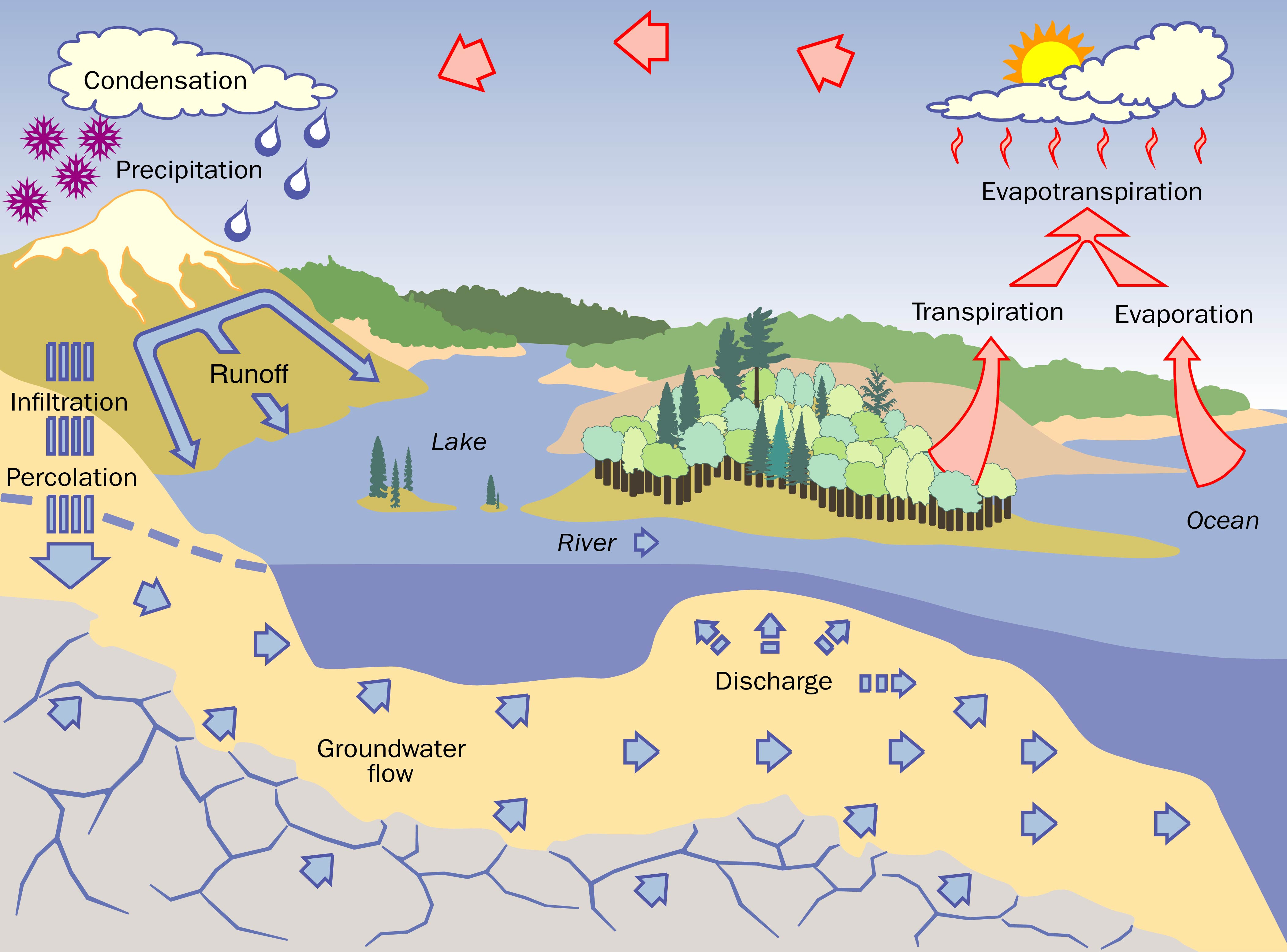
Water’s endless journey takes a series of pathways called the hydrologic cycle or the water cycle (Figure 1). Rain (or melting snow) at the soil surface can take several routes. It can run off over land into surface water bodies such as streams or lakes. It can seep (infiltrate) into the ground to be used directly by plants or to recharge groundwater. It can evaporate from the ground or surface water bodies or be released by plants (transpiration) to return to the atmosphere in a process called evapotranspiration. The cycle is complete when water in the atmosphere returns to the land as rain or snow.
Water in the ground
Groundwater is water that seeps into the ground and passes through subsurface materials such as soil, sediment and bedrock. Eventually it reaches a spring, stream, lake or wetland, where it discharges to the surface, becoming surface water. This may take as little as a few days or as much as centuries.
Groundwater is found in and moves through subsurface materials. Near and below the surface, there are different types of bedrock, such as granite, shale, sandstone and limestone. In many areas, the bedrock is covered with soil and deposits of sediments, including clay, silt, sand or gravel. A layer of bedrock or sediment that consists primarily of a certain type (or combination of types) of geological material is called a “formation.”
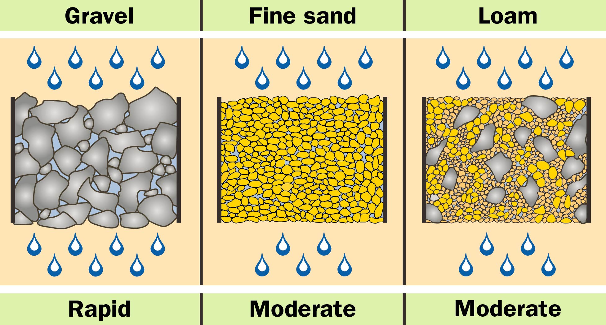
Geological formations contain pores or small openings. The percentage of the total volume of pore space in bedrock or sediment is called its “porosity.” The greater the porosity of a formation, the greater the volume of water that can be held in the pores. Different formations have different degrees of porosity. For example, sand and gravel formations can have a porosity percentage as high as 25%–50%, while for dense, solid bedrock, it may be less than 0.1%.
The rate (slow to rapid) and amount of water that can move through a formation depends on its porosity and on how well the pores are connected. Large amounts of water move rapidly through formations with many large connected pores, such as gravel or highly fractured bedrock (water flows through cracks and fractures in the rock instead of through pore spaces). Water moves slowly through formations with small, poorly connected pores such as clay. Formations that allow large amounts of water to flow rapidly, such as sand and gravel deposits or sandstone, are called highly permeable. In contrast, clay, silt and granite formations are much less permeable (Figure 2).
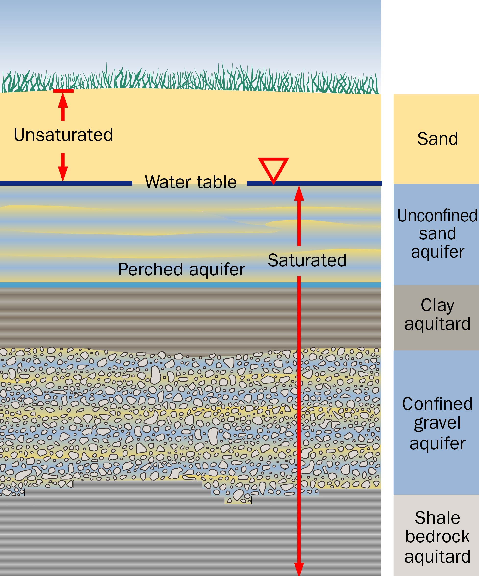
Near the ground surface, pores usually contain a mixture of air and water — in water terms, they are considered unsaturated. At greater depths, the pores become full of water or completely saturated. The water table is defined as the level in the ground above which pores are unsaturated, and below which pores are saturated.
Over time, the water table moves up and down with changes resulting from variations in rainfall, evapotranspiration and the pumping of wells. All wells draw their water from below the water table.
Recharging water collects and forms a perched aquifer on a layer of low permeable sediment, located above the main water table. Perched aquifers are usually small and are usually not a reliable source of groundwater.
Pumping a well changes the amount and direction of movement of groundwater within the subsurface. This concept is explored in more detail in the OMAFRA fact sheet, Managing the quantity of groundwater supplies.
In Ontario, Regulation 903 (the Wells Regulation) prescribes requirements for the construction, maintenance and abandonment of private water wells. The Wells Regulation requires that the well owner must maintain the well in a way that prevents the entry of surface water and other foreign materials into the well. Proper construction and maintenance of a well will help prevent it from becoming a pathway for surface water and contaminants to reach the groundwater. If a well is no longer used, it must be properly abandoned (plugged and sealed). The requirements for construction change periodically, and it is recommended that well owners refer to the current requirements under the Wells Regulation.
Aquifers and aquitards
An aquifer is a permeable, saturated formation that will yield useful amounts of water when pumped. The most productive aquifers, such as sands and gravels, are typically thick and large in area and are replenished or recharged by infiltrating rainwater. Other formations, called aquitards (or confining layers), are made up of materials with low permeability, such as layers of clay and shale, which prevent any significant movement of water. Contrary to popular belief, groundwater does not flow in underground rivers.
There are three main types of aquifers:
Unconfined aquifers (or water table aquifers) — where the top of the aquifer is also the water table
Confined aquifers — where the permeable formation is located below an aquitard or confined between two aquitards
Semi-confined aquifers or “leaky” aquifers — similar to a confined aquifer, except that the aquitards next to it are more permeable and let significant amounts of water move through them to the aquifer
Unconfined aquifers are often the shallowest and most easily accessed, whereas confined and semi-confined aquifers are often found at greater depths. The greater the depth, thickness and type of material overlying a semi-confined or confined aquifer, the less prone it, and the groundwater it contains, is to contamination. The importance of this is discussed in the OMAFRA fact sheets Protecting the quality of groundwater supplies and Highly vulnerable water sources.
Figure 3 shows examples of different aquifers. For the unconfined sand aquifer, the water table is also the top of the aquifer. The confined gravel aquifer occurs where the permeable formation is confined and is located below the clay aquitard and above the shale bedrock aquitard as shown.
How groundwater flows
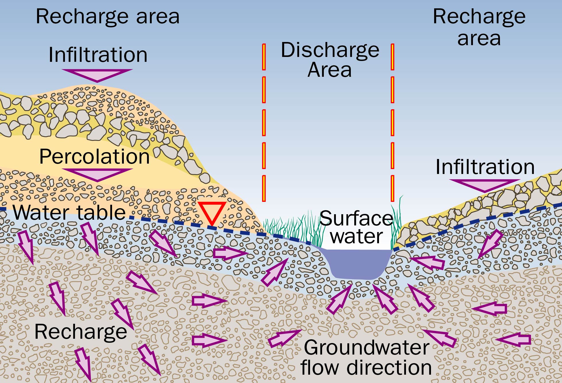
Water infiltrates below ground and recharges groundwater in areas where permeable deposits are found at the ground surface. Once in the aquifer, the permeability, porosity and other factors determine how fast the groundwater moves.
Groundwater can flow a few centimetres to a few metres a day in sand or gravel aquifers, and tens of metres a day (rapid) or more in some highly fractured bedrock aquifers. In some aquitards, the water may move less than a few millimetres in a day (slow). In general, groundwater moves from areas of recharge toward areas of discharge such as springs, streams, lakes or wetlands, etc. Water infiltrating or recharging in the hills or uplands of a river valley travels down to the water table aquifer, then moves horizontally through the various formations until it reaches and discharges into a surface water body.
The exact path that the water flows along can be complex, but most of the water will take the path of least resistance, flowing through the most permeable formations. Some recharged water can also flow downward through unconfined aquifers to recharge deeper confined aquifers. Eventually it flows to discharge locations that can be several kilometres away.
Recharge areas
Recharge areas infiltrate a significant amount of water into the subsurface. Sometimes these areas are concentrated, covering a small part of the total land area. For instance, 80% of the groundwater recharge may occur in 20% of the land area that has more permeable sands and gravels.
In other places with a flat landscape or low‑permeability soils (such as clays and silts), a small amount of infiltration may take place over a large area. Wherever precipitation happens, there is potential for some amount of infiltration and recharge to occur (Figure 4).
Age of groundwater
The age of groundwater refers to how long the water has been in the ground. It may take a very long time between the time the water infiltrates into the ground to when the water reaches a discharge area or is pumped from the ground through a well. Several methods are used to find which way groundwater is moving, how fast it is moving and its age.
For shallow water wells constructed in the top of permeable unconfined aquifers, the pumped groundwater may only be weeks, months or years old. For deep wells constructed in confined aquifers, the pumped groundwater may be decades to hundreds of years old — sometimes even older!
The importance of water’s age in protecting individual water wells is explained in more detail in the OMAFRA fact sheets Protecting the quality of groundwater supplies and Highly vulnerable water sources.
A reliable supply of potable water is essential to our health and the health of rural business, especially the farm operation. Knowing how water moves and is replenished will help minimize the risk of contamination. Regular testing is a good way to monitor water quality. When a well produces water that is not potable, the well owner may seek advice and take steps directed by the local public health unit as an alternative to immediately abandoning the well.
Information on how and when to test your private water well, and how to interpret the test results is provided in the OMAFRA fact sheet, Testing and treating private water wells. Information on how to disinfect your private water well is provided in the OMAFRA fact sheet Disinfecting private water wells.
This fact sheet is consistent with, but does not reflect the full detail, of the Wells Regulation. For assistance with the Regulation, seek advice from the Ontario Ministry of the Environment, Conservation and Parks (MECP) through the Wells Help Desk. Call
Resources
Ontario Ministry of the Environment, Conservation and Parks:
Ontario Soil and Crop Association:
- Information on different actions that can be taken to protect the quality of groundwater and your drinking water supply is provided in the Canada-Ontario Environmental Farm Plan workbook and associated Infosheets.
This fact sheet was updated by Dr. Hugh Simpson, program analyst (retired), OMAFRA, Jim Myslik, JPM consulting and Brewster Conant, Jr. It was reviewed by John Warbick, engineer, crop systems & environment, OMAFRA.