Woodland Caribou Recovery Strategy
Read the strategy for the recovery of Woodland Caribou, a species at risk in Ontario.
Species Conservation Act now in force
The Endangered Species Act, 2007 (ESA) and its regulations have been repealed. The Species Conservation Act, 2025 (SCA) and its regulations are now in force. Find more information on the Environmental Registry of Ontario (notice 025-0380 , notice 025-0909) and e‑Laws.
This information provides general guidance only. If you are planning an activity that may affect a species on the Protected Species in Ontario List, review the SCA and its regulations. You should also seek appropriate advice, such as legal or scientific advice, or contact SAROntario@ontario.ca.
If there is any inconsistency between this webpage and the SCA or its regulations, the legislation prevails.
About the Ontario recovery strategy series
This series presents the collection of recovery strategies that are prepared or adopted as advice to the Province of Ontario on the recommended approach to recover species at risk. The Province ensures the preparation of recovery strategies to meet its commitments to recover species at risk under the Endangered Species Act, 2007 (ESA, 2007) and the Accord for the Protection of Species at Risk in Canada.
What is recovery?
Recovery of species at risk is the process by which the decline of an endangered, threatened, or extirpated species is arrested or reversed, and threats are removed or reduced to improve the likelihood of a species’ persistence in the wild.
What is a recovery strategy?
Under the ESA, 2007, a recovery strategy provides the best available scientific knowledge on what is required to achieve recovery of a species. A recovery strategy outlines the habitat needs and the threats to the survival and recovery of the species. It also makes recommendations on the objectives for protection and recovery, the approaches to achieve those objectives, and the area that should be considered in the development of a habitat regulation. Sections 11 to 15 of the ESA, 2007 outline the required content and timelines for developing recovery strategies published in this series.
Recovery strategies are required to be prepared for endangered and threatened species within one or two years respectively of the species being added to the Species at Risk in Ontario list. There is a transition period of five years (until June 30, 2013) to develop recovery strategies for those species listed as endangered or threatened in the schedules of the ESA, 2007. Recovery strategies are required to be prepared for extirpated species only if reintroduction is considered feasible.
What’s next?
Nine months after the completion of a recovery strategy a government response statement will be published which summarizes the actions that the Government of Ontario intends to take in response to the strategy.The successful implementation of recovery strategies is dependent on the continued cooperation and actions of many partners including all levels of government, individuals, aboriginal communities, land users, and conservationists.
For more information
To learn more about species at risk recovery in Ontario, please visit the Species at Risk webpage.
Adoption of recovery strategy
The Recovery Strategy for Woodland Caribou (Forest-dwelling, Boreal population) in Ontario was prepared prior to June 30, 2008 to meet the Ontario government’s commitments under the Accord for the Protection of Species at Risk in Canada. This recovery strategy is being adopted under the Endangered Species Act, 2007 (ESA, 2007), which requires the Minister of Natural Resources to ensure recovery strategies are prepared for all species listed as endangered or threatened. With the additions indicated below, the enclosed strategy meets all of the content requirements outlined in the ESA 2007.
Recommendations for habitat regulation
The ESA, 2007 requires that a recovery strategy include recommendations on the areas that should be considered in developing a habitat regulation. Section 4.0 of the recovery strategy outlines an approach to identifying recovery habitat and provides recommendations on how that habitat should be protected. This section is considered to meet the intent of the ESA, 2007 content requirements and this information will be considered in the habitat regulation process.
Recommended citation
Ontario Woodland Caribou Recovery Team. 2008. Woodland Caribou (Rangifer tarandus caribou) (Forest-dwelling, Boreal Population) in Ontario. Prepared for the Ontario Ministry of Natural Resources, Peterborough, Ontario. 93 pp.
Content (excluding the cover illustration) may be used without permission, with appropriate credit to the source.
Declaration
The Ontario Ministry of Natural Resources has led the development of this recovery strategy for the Woodland Caribou (forest-dwelling, boreal population), under the Accord for the Protection of Species at Risk in Canada.
This proposed recovery strategy has been prepared as advice to the responsible jurisdictions and the many different constituencies that may be involved in recovering the species. The recovery strategy does not necessarily represent the views of all individuals of the recovery team or the official positions of the organizations with which the individual recovery team members are associated.
The goals, objectives and recovery approaches identified in the strategy are based on the best existing knowledge and are subject to modifications resulting from new findings and revised objectives. Implementation of this strategy is subject to appropriations, priorities, and budgetary constraints of the participating jurisdictions and organizations.
Success in the recovery of this species depends on the commitment and cooperation of many different constituencies that will be involved in implementing the directions set out in this strategy.
Recovery team members (current and former)
- Ted Armstrong (Co-chair) - Northwest Region, OMNR, Thunder Bay
- Peter Davis (Co-chair) - Northeast Region, OMNR, South Porcupine
- Rodger Leith (Co-chair)
footnote 1 - Northeast Region, OMNR, South Porcupine - James Rettie (Co-chair)
footnote 1 - Northeast Science & Information, OMNR, South Porcupine - Brad Allison - Centre for Northwest Forest Ecosystem Research, OMNR, Thunder Bay
- Glen Brown - Northeast Science & Information, OMNR, South Porcupine
- Natasha Carr - Northwest Park Zone, OMNR, Thunder Bay
- Jenn Chikoski - Northwest Region, OMNR, Thunder Bay
- Neil Dawson - Northwest Science & Information, OMNR, Thunder Bay
- Mike Ferguson - Parks Canada, Pukaskwa National Park, Marathon
- Steve Ferguson
footnote 1 - Lakehead University, Thunder Bay - Mick Gauthier - Cochrane District, OMNR, Cochrane
- Hilary Gignac - Northwest Region, OMNR, Thunder Bay
- Jeri Graham - Sioux Lookout District, OMNR, Sioux Lookout
- Karen Hartley - Species at Risk Unit, OMNR, Peterborough
- Rosemary Hartley - Nipigon District, OMNR, Nipigon
- Glen Hooper - Northwest Region, OMNR, Thunder Bay
- Brian Hutchinson - Parks Canada, Ottawa
- Steve Kingston - Northwest Park Zone, OMNR, Thunder Bay
- Dana Kinsman - Forest Management Planning Section, OMNR, Sault Ste. Marie
- Catherine Lipsett-Moore
footnote 1 - Northwest Region, OMNR, Thunder Bay - Geoff Lipsett-Moore
footnote 1 - Northwest Park Zone, OMNR, Thunder Bay - Greg Lucking - Northeast Region, OMNR, South Porcupine
- Kirsten Querbach - Parks Canada, Peterborough
- Gerry Racey - Northwest Science and Information, OMNR, Thunder Bay
- Art Rodgers - Centre for Northern Forest Ecosystem Research, OMNR, Thunder Bay
- Arnie Saari
footnote 1 - Sioux Lookout District, OMNR, Sioux Lookout - Jim Schaefer
footnote 1 - Trent University, Peterborough - Barb Selkirk
footnote 1 - Species at Risk Unit, OMNR, Peterborough - Jen Theberge
footnote 1 - Parks Canada, Pukaskwa National Park, Marathon - Keith Wade
footnote 1 - Parks Canada, Pukaskwa National Park, Marathon - Lyle Walton - Northeast Region, OMNR, South Porcupine
Acknowledgements
The Ontario Woodland Caribou Recovery Team acknowledges the leadership and generous financial support of the Province of Ontario (OMNR - Species at Risk Program and Ontario's Living Legacy) and the Government of Canada (Federal Species at Risk Habitat Stewardship Program). Input and advice from the Ontario Woodland Caribou Advisory Committee was very helpful in developing the Recovery Strategy, as were OMNR review comments and public comments from the posting of the draft Recovery Strategy on the Environmental Registry.
This recovery strategy has benefited greatly from the past input and involvement of several former recovery team member and co-chairs, and their involvement and assistance are acknowledged.
Executive summary
Woodland caribou (Rangifer tarandus caribou) (forest-dwelling, boreal population) have disappeared from much of their historical range in Ontario and other parts of Canada and the United States. In Ontario, it has been estimated that the range of forest-dwelling woodland caribou has decreased by 40% to 50% since the mid-1800s. The decline in caribou range and populations has been attributed to several inter-related factors, including human settlement and land clearing, forest harvesting, landscape fragmentation, past over-hunting, disease and predation.
The boreal population of forest-dwelling woodland caribou is designated as Threatened by OMNR, and is also designated as Threatened by the Committee on the Status of Endangered Wildlife in Canada (COSEWIC) and listed in Schedule 1 of the federal Species at Risk Act. This provincial Recovery Strategy has been prepared to improve the status of forest-dwelling woodland caribou in Ontario by providing guidance and advice on the actions needed for recovery of the species. Concurrently, the National Boreal Caribou Technical Steering Committee has been developing a National Recovery Strategy for Woodland Caribou, Boreal Population. The Province of Ontario is represented on this committee, to ensure actions taken in Ontario are integrated with those taken by other provinces and territories.
The goal of the provincial Woodland Caribou Recovery Strategy is to "Maintain self-sustaining, genetically-connected local populations of forest-dwelling woodland caribou where they currently exist; ensure security for and (reproductive) connections among currently isolated mainland local populations; and re-establish caribou in strategically selected landscape units to achieve self-sustaining local populations and ensure connectivity."
Woodland caribou recovery in Ontario is considered biologically and technically feasible. To meet the recovery goal, 11 recovery objectives have been identified as well as a number of recommended recovery approaches. This Recovery Strategy is intended to be the first part of a two-part recovery plan. The second part of the recovery plan, consisting of one or more action plans, is still to be developed. Five recovery zones that encompass all of Ontario's range for forest-dwelling woodland caribou are proposed based on differences in caribou distribution, ecological conditions, and threats. Specific guiding principles are proposed for each recovery zone to assist with the development of individual action plans. It is anticipated that the success of the Recovery Strategy will be evaluated based on a number of indicators, with provincial range occupancy and population health acting as the overall measures of caribou recovery. Recovery success will depend on a long-term commitment and a balance of art and science, to recognize where recovery is biologically, socially, and economically feasible, and where it is not.
Introduction
The boreal population of forest-dwelling woodland caribou
In response to the Threatened designation of caribou, an Ontario Woodland Caribou Recovery Team (henceforward recovery team) was established to develop the Recovery Strategy for Woodland Caribou in Ontario (henceforward recovery strategy or strategy) to provide direction and advice on the actions needed to improve the status of caribou in Ontario. The recovery strategy is intended to be the first part of a two-part recovery plan. The second part of the recovery plan, consisting of one or more action plans, is still to be developed. This strategy is the most recent initiative to protect and recover caribou in the province and builds upon earlier work. In the past two decades, substantial effort has been directed at the conservation of caribou populations and habitats (see Section 9.0). It is expected that the strategy will be reviewed every five years, providing the opportunity to incorporate new knowledge into management actions and complete the adaptive management cycle.
The recovery strategy was developed with input from the Ontario Woodland Caribou Recovery Advisory Committee, a stakeholder group comprised of representatives from forestry, mining, prospecting, trapping, tourism, conservation, environmental and municipal organizations and the academic community. First Nation treaty organizations and communities within caribou range were contacted during the development of the strategy to invite discussion and involvement in caribou recovery. Additional input is expected from First Nations, other organizations and the public as action plans are developed. It is anticipated that actions taken in Ontario will be integrated with those taken by other Canadian jurisdictions through inter-agency dialogue and representation on the National Boreal Caribou Technical Steering Committee.
A multi-scalar landscape approach to the recovery of woodland caribou is required, due to the scale at which caribou use the boreal forest landscape, and seasonal and geographical variations in habitat use and threats across Ontario. Five recovery zones are proposed based on ecoregional boundaries, areas of known caribou use and known regional threats. Strategic principles and approaches to management and habitat conservation are identified to assist with the development and implementation of geographically-based action plans for recovery zones.
Recovery of woodland caribou will require the resolution of complex biological, social and economic issues, and involves the maintenance and suitable positioning of large tracts of mature forest, which may limit some land and resource uses. Recovery initiatives will apply to large areas, and will require a sustained commitment and consideration of social and environmental trends over many decades.
Organization of the recovery strategy
The recovery strategy was prepared based on the template provided in the national guidelines for recovery planning (National Recovery Working Group 2001). There are two primary components to the strategy, those being recovery and background.
Section III (Recovery) includes the recovery goal, objectives, recommended strategies to achieve the objectives in support of the goal, approaches to habitat identification and conservation, recovery potential, recent and current research, and anticipated challenges. Strategic principles for each recovery zone are proposed and indicators are described to evaluate the success of the recovery strategy.
Section IV (Background) provides the context for the goal, objectives and recommended recovery approaches presented in the first part of the recovery strategy. This part of the document includes information on caribou biology, distribution and populations, threats and biologically limiting factors, habitat requirements, and knowledge gaps.
Sections III and IV are interdependent and must be considered together in assessing the strategic direction provided in this recovery strategy and in developing and implementing action plans.
Recovery
1.0 Recovery goal
The recovery team has identified the following recovery goal to improve the status of woodland caribou in the province from its current threatened designation to a lower risk category:
"Maintain self-sustaining, genetically-connected local populations of forest-dwelling woodland caribou where they currently exist; ensure security for and (reproductive) connections among currently isolated mainland local populations; and re-establish caribou in strategically selected landscape units to achieve self-sustaining local populations and ensure connectivity."
2.0 Recovery objectives
The Recovery Team has developed the following recovery objectives to guide both development and implementation of the Recovery Strategy and associated action plans:
- Maintain or enhance the status and health of provincial and local woodland caribou populations consistent with the strategic principles for specific recovery zones across Ontario.
- Protect caribou ranges in support of local caribou survival and recovery.
- Reduce known threats associated with range recession and local population decline of woodland caribou through immediate action on ranges within the Lake Nipigon, Central Highlands, and Lake Superior Coast recovery zones.
- Reduce known threats associated with provincial range recession and local population decline in the area of continuous woodland caribou range, specifically in the northwest and northeast recovery zones.
- Delineate and establish range management plans for all caribou ranges, including specific objectives for range components.
- Develop policies and legislation to promote the protection and recovery of woodland caribou.
- Establish benchmarks for range occupancy and population health of woodland caribou across Ontario in order to track changes and monitor recovery.
- Establish and maintain a woodland caribou range occupancy database and related map to track changes in occurrence and connectivity of populations to monitor recovery.
- Define metapopulations, refine recovery zones and identify recovery priorities by investigating genetic relationships among local woodland caribou populations in Ontario.
- Better understand populations, metapopulations, habitat, threats, genetics, and other knowledge gaps by conducting and supporting scientific research to support recovery.
- Generate support and partnerships for recovery implementation by promoting education and awareness of woodland caribou and boreal forest ecosystems.
3.0 Strategies and approaches for recovery
Recommended recovery actions and approaches considered necessary to achieve the objectives are listed in Table 1, sub-divided into the following categories:
- Legislation and policy;
- Inventory, monitoring and reporting;
- Population management;
- Land use planning and management;
- Habitat management;
- Research; and
- Communications and outreach.
These categories are not mutually exclusive; several of the recovery approaches require coordinated implementation and could not be efficiently implemented alone. Specific recovery approaches have been ranked as 'High', 'Medium', or 'Low' priority based on an assessment of relative urgency and contribution to the recovery goal and objectives. This priority ranking may change for individual recovery zones as action plans are developed. The context and rationale for these recovery approaches are discussed in detail in the subsequent text of this recovery strategy.
The recovery team endorses the precautionary principle, i.e. "where there are threats of serious or irreversible damage, lack of full scientific certainty shall not be used as a reason for postponing cost-effective measures to prevent environmental degradation" (Cooney 2004), and adaptive management (Walters 1986) where feasible, to implement, monitor and adjust management policies and practices. Adaptive management and the precautionary principle go hand in hand; the management approaches that are chosen should minimize the probability of undesired or irreversible outcomes and maximize the probability of caribou recovery.
4.0 Recommended approach to identification and protection of habitat
Recovery zones have been proposed to provide geographical context for future action planning, with the biological unit of conservation being the local population
The following outlines a recommended approach to the identification and protection of habitat necessary for the survival and recovery of woodland caribou in Ontario, in support of the goal of this strategy (see Section 1.0). The concepts are adapted from and consistent with the approaches under development by the National Boreal Caribou Technical Steering Committee.
Generally, woodland caribou require seasonal ranges in the order of tens, hundreds, or thousands of square kilometres of undisturbed or little-disturbed boreal forest (Racey et al. 1999, Rettie and Messier 2001, Brown et al. 2003). Specific requirements vary with local conditions, but large areas are a defining characteristic of caribou habitat. Identification and delineation of habitat for the maintenance of self-sustaining populations must address appropriate spatial and temporal scales, and functional roles for various range components.
The proposed approach to identifying and affording effective protection for woodland caribou habitat is consistent with the following concepts:
- Specific habitat requirements must be taken into account at multiple spatial scales, as woodland caribou satisfy their life requirements at different scales. Generally, habitat to reduce predation is provided at coarser scales (e.g. the landscape level requirement for a continuous supply of large tracts of suitable habitat within which woodland caribou can reduce predation risk), and habitat for forage or calving is provided at finer scales (e.g. the need for appropriate forest patches or stands that produce lichens and other forage).
- Specific habitat requirements must be considered and addressed at multiple temporal scales. The dynamic nature of the boreal forest, and hence woodland caribou habitats, must be incorporated into recovery habitat identification, planning and management. Caribou habitat can be degraded by both natural factors and human disturbances, but it can recover naturally, given sufficient time for vegetation growth and succession, or by active management for habitat renewal or reclamation (Racey et al. 1996). Hence the spatial configuration of habitat components within a range will change over time, although the overall habitat requirements of a given local population may remain relatively constant. There are many management implications of considering multiple temporal scales in recovery habitat identification. For instance, the potential for catastrophic events, such as a major wildfire, could be addressed by maintaining sufficient areas of suitable replacement habitat on the landscape, even if not currently used by woodland caribou. In addition, recovery habitat planning must incorporate appropriate timeframes for habitat recovery or restoration following disturbance. Planning for areas that may be suitable in the future should be a component of a long-term range management plan, but should not occur at the expense of currently occupied and suitable ranges.
- Recovery habitat planning and management must consider the ecological functions provided by habitat, in addition to physical features such as vegetation cover or topographic features. It is important to recognize that the value of habitats to woodland caribou can be compromised by human developments (e.g. roads, utility corridors, human activities, etc.), even if actual forest stands remain largely intact. Various studies have demonstrated that woodland caribou avoid the vicinity of industrial and other human developments, even when forest habitat conditions adjacent to these developments are otherwise suitable (Dyer et al. 2001, Mahoney and Schaefer 2001, Dyer et al. 2002), resulting in functional habitat loss. Industrial developments can also directly increase the probability of caribou mortality as the associated linear features allow access for harvesters, poachers or predators.
4.1 Identification of woodland caribou ranges
Landscape-level habitat management has the greatest potential to contribute to, and is necessary for, woodland caribou recovery (e.g. Seip 1998, Racey et al. 1999, Courtois et al. 2004). Therefore, local population ranges are considered equivalent to recovery habitat for this species. Ranges, and their key range components (e.g. seasonal ranges, high use areas and calving sites), collectively provide for the sustainability of local populations by meeting their life history requirements.
The range provides the ecological and management context within which range components provide for the life history requirements of caribou. After range delineation, it will be necessary to identify and provide for effective protection of range components and ecological functions within each range over space and time. Affording effective spatial and temporal protection to individual range components must be done within the context of the entire range and with consideration of all other range components. Recovery habitat may include working landscapes managed to support self-sustaining local populations of woodland caribou, as well as parks and other protected areas. Once population ranges have been delineated, industrial and other human activities may occur within recovery habitat, as long as such activities are compatible with caribou recovery and provide an adequate amount and spatial distribution of necessary habitat components through time. Examples of range delineation criteria, habitat functions, activities likely to impair caribou habitat quality, and measures contributing to effective protection for range components are described in Appendix A-1. It is understood that protection in this context can include active resource management activities. Management plans for caribou ranges, which may take several forms, must be designed to achieve the provisions of a sustainable habitat supply over time.
The general approach to the identification and delineation of caribou ranges (recovery habitat) can be described in four broad steps:
- Assemble knowledge (both western and indigenous) on habitat suitability, current and historical range occupancy, habitat use patterns and other information that supports inferences about habitat required to support self-sustaining populations.
- Delineate caribou ranges using one of two methods:
- The first method, recommended for discrete or isolated populations that are geographically isolated by water (e.g. Lake Superior) or by habitat loss, is to delineate range to encompass the current local caribou population distribution (based on best available information and professional judgment). These ranges may include areas that are currently unoccupied and areas that provide for projected future woodland caribou use.
- The second range delineation method, recommended for diffuse and/or wide-ranging populations or metapopulations on highly dynamic landscapes (i.e. the majority of caribou distribution in Ontario), is to delineate a portion of the boreal forest landscape based on biophysical characteristics and management considerations, within which a self-sustaining local population of caribou may be sustained. Special consideration is needed to determine the amount of space required to support a viable local population, the spatial arrangement and abundance of range components, alternate and projected future habitat use, and the anticipated natural and anthropogenic disturbance regime. In general, the caribou ranges will be large and consistent with the nature and extent of the human and natural disturbance regime, and will often be contiguous with one another.
- Consider historical range and habitat connectivity between local populations.
- Determine the amount and spatial distribution of individual range components required within the caribou ranges. To the extent possible, and bearing in mind the precautionary principle, this process should strive to specify the type, quality, amount and spatial distribution of habitat components required now and into the future to provide for self-sustaining local caribou populations, and to meet the goal and objectives of the recovery strategy.
4.2 Destruction or degradation of habitat
Human developments or natural disturbances that result in landscape alteration are risk factors that have the potential to destroy habitat
The effects of human developments and natural disturbances should be evaluated and managed at appropriate temporal and spatial scales for each range component. For example, a wildfire may have a substantial effect on habitat quality at the forest stand level or even a large portion of a single seasonal range, while at the range level the effects may be minimal if alternate habitats and multiple range components exist within the range. The reverse may also be true, with developments such as linear features having relatively minor effects at the stand level but substantial cumulative effects at the range level.
4.3 Recommended approaches to habitat protection
Human developments and natural disturbances can act cumulatively to reduce the quantity and quality of ranges or their components and hence should be jointly and concurrently managed. One approach is to stipulate targets or thresholds for acceptable levels of habitat change within woodland caribou ranges. Hence "protection" means to protect ranges, associated range components and essential habitat functions through management of the amount and type of human developments and potential natural disturbances, not by prohibiting all activity. The landscape, stand and site, and silviculture forest management guides being developed by the Ministry of Natural Resources will provide an important tool to integrate landscape analysis, allocation of human development activities and target setting, and work towards target achievement for range and range component composition (see recovery approaches 26 and 27, Table 1).
Measures must be identified and put in place to maintain, and where required improve, the integrity of ranges and range components at appropriate spatial scales. Habitat protection may take a variety of forms from managing very coarse landscape patterns to provide for the distribution of seasonal ranges, connectivity and alternate habitats using habitat planning targets, to fine-scale or stand level prescriptions related to silvicultural treatments or access road management relevant to caribou refuge, foraging or calving site conditions. Assessment and management of the cumulative effects of disturbances to caribou habitat and populations will generally be required. Caribou are long-lived, have low fecundity, and are dependent on components within a range to provide essential habitat functions. The cumulative effects of multiple disturbance factors may have a delayed impact on local caribou populations, taking considerable time to become evident (Schaefer 2003, Vors 2006). Once cumulative impacts exceed a threshold value, it can be very difficult and potentially nearly impossible to alter the outcome. Therefore, any thresholds for human activity, habitat change or natural disturbances on woodland caribou ranges derived from studies of current conditions must consider cumulative effects, the likelihood of a delayed response and the potential for overestimation of threshold values.
4.4 Habitat protection and land ownership
Caribou habitat occurs almost exclusively on public land. Parks and protected areas (i.e. national and provincial parks, and conservation reserves) can contribute to recovery habitat provided that important habitat attributes and functions are maintained over time, and boreal forest dynamics within those protected areas contribute to overall range integrity.
Parks and protected areas can provide refuge to caribou by reducing many of the known threats to caribou persistence (see Section 12), and maintaining a natural predator-prey community balance. Most of the southern remnant caribou populations persist within parks on the north shore of Lake Superior (e.g. Pukaskwa National Park, and Lake Superior, Michipicoten Island, Neys and Slate Islands provincial parks). Some northern provincial parks, especially the large wilderness class parks such as Opasquia, Wabakimi and Woodland Caribou, provide not only refuge value for local populations and anchors to support caribou recovery across occupied range, but also benchmarks to support the monitoring of caribou conservation on the broader landscape (Duinker et al. 1998). The recent addition of new protected areas (e.g. Nagagamisis, St. Raphael and Lake Nipigon signature sites) (OMNR 1999b) further increased caribou habitat protection.
Guidance on the modification of forest management practices to protect caribou habitat are currently provided in northwestern Ontario through the application of OMNR’s forest management guidelines (Racey et al. 1999). Regional direction for forest management planning in woodland caribou range in northeastern Ontario is currently being developed (OMNR 2006b).
5.0 Proposed approach to recovery implementation
The national model for recovery planning proposes a two-part process consisting of the development of a recovery strategy followed by the preparation of one or more action plans. Action plans are intended to elaborate on and operationalize recommendations in recovery strategies, while ensuring consideration of the socio-economic effects of implementing recovery actions. Due to the complexity of caribou recovery, the large number of stakeholders, and the potential for socio-economic impacts, it is strongly recommended that this approach be adopted to facilitate and coordinate implementation of this recovery strategy.
An approach for organizing the development and delivery of action plans is proposed below, involving establishment of recovery implementation groups (RIGs) to prepare action plans for geographically-defined recovery zones.
5.1 Recommended scale for recovery
Recovery initiatives will apply to local populations and their ranges within and across recovery zones and will require a sustained commitment and consideration of social and environmental trends over many decades. Recovery zones are recommended as a basis for recovery action plans. The recovery of woodland caribou will involve the maintenance and provision of large tracts of mature conifer-dominated forest and restrictions on some land uses consistent with the proposed approach to recovery habitat (see Appendix A-1). The maintenance of large tracts of mature conifer-dominated forest as a recovery approach for woodland caribou will benefit many boreal forest species (particularly wolverine (Gulo gulo) – see Section 8.2.1) as well as ecosystem processes and linkages.
5.2 Recovery zones
Five recovery zones (Figure 1 and Table 2) are proposed to provide a geographic context within which recovery actions are proposed, evaluated and implemented, and within which ranges will be delineated. Recovery zones include all areas currently occupied by woodland caribou as well as historically occupied areas where there is a biologically feasible opportunity for successful reoccupation (i.e. includes all proposed recovery habitat). The five recommended recovery zones are the:
- Central Highlands;
- Lake Nipigon;
- Lake Superior Coast;
- Northeast; and
- Northwest recovery zones.
Recovery zones provide a context and scale for future action plans, and are based on ecoregional or ecodistrict boundaries (Crins et al. 2006), social (e.g. roads, communities, historical development patterns) and ecological factors. Ranges may span recovery zone boundaries. In much of the Northwest and Northeast recovery zones, ranges will be contiguous with each other and will have some degree of animal exchange among them.
A recovery zone may include areas of suitable caribou habitat, as well as areas where the management of forests, wildlife and human activity may be required to reduce risk to caribou survival within ranges. The designation of a recovery zone does not imply management actions to recover caribou will occur across the entire zone, or that the entire area within the recovery zone will be identified as part of a caribou range for the identification and protection of recovery habitat. Each recovery zone will require specific management approaches that maintain an adequate spatial arrangement of suitable habitat over time, consistent with preliminary recovery zone objectives (Appendix A-2). Recovery zones are considered that portion of historic caribou range most likely to contribute significantly to the maintenance and support of self-sustaining local populations, although continued occupancy (i.e. multiple, successive observations in the same vicinity) of areas by caribou outside these recovery zones would still require a management response.
5.3 Recovery implementation groups and action plans
The recovery team recommends the immediate establishment of recovery implementation groups (RIGs) to develop and coordinate the delivery of action plans, consistent with the recovery strategy’s goal and objectives for each of the five recovery zones. Until an action plan is completed, the recovery team strongly recommends that the OMNR continues to apply existing OMNR management direction and legislation as follows:
- for northwestern Ontario, the existing Northwest Region caribou management framework (OMNR 1999a) and the Forest Management Guidelines for the Conservation of Woodland Caribou (Racey et al. 1999); and,
- for northeastern Ontario, direction for forest management plans in woodland caribou range that is currently being developed (OMNR 2006b). Interim regional direction, which provides the current legal and planning context to address caribou habitat needs in forest management plans across recovery zones, is in place.
Given the high risk to many local populations in Ontario, it is essential that RIGs be established, and action plans initiated and completed as soon as possible. It is recommended that a central coordination body be identified for RIGs (see Section 5.4) as it is anticipated that several recovery approaches will be common to more than one recovery zone. As such, harmonization of efforts will lead to increased efficiencies and effectiveness of recovery actions, while avoiding duplication of effort amongst RIGs. Ongoing caribou management and conservation efforts are expected to continue while action planning is underway, and it is anticipated that RIGs may recommend the immediate implementation of specific actions considered necessary to reduce known threats while action plans are being developed.
Three regionally based RIGs are proposed: 1) Lake Nipigon-Central Highlands-Lake Superior Coast; 2) Northwest and; 3) Northeast Recovery Zone. RIGs should be responsible for developing and coordinating the implementation of recovery action plans consistent with the goals and objectives of the Recovery Strategy. Representation should be encouraged from people with caribou expertise as well as community, industrial, environmental, government, First Nation, academic and resource groups. RIGs would be expected to provide a forum for local and regional representatives of government agencies, First Nations and stakeholders to discuss and coordinate implementation of action plans. Both biological and socio-economic evaluations should be considered during the development of action plans.
The recovery team recognized that some recovery approaches were better addressed, or were more urgently required, in some recovery zones than in others. Appendices A-1 and A-2 contain recommendations specific to each recovery zone.
First Nations have a unique and important role in the conservation and recovery of woodland caribou due to the significance of this species to some communities, and the exercise of Aboriginal and treaty rights. In view of this, a separate process for establishing dialogue and partnerships with First Nations for action planning and implementation of the strategy may be desirable.
5.4 Provincial woodland caribou recovery team or technical committee
In addition to zone-specific management recommendations for individual action plans, there will be a need to integrate some actions across all action plans and recovery zones. Some actions will be common to all action plans, and there will also be a need to address some non-geographically-based policy, management and technical concerns. There will continue to be a need for a team to coordinate and advise on caribou recovery implementation, including such matters as:
- the integration of actions or action plans;
- the development of communications and education strategies;
- information management;
- research, inventory, and monitoring;
- the evaluation and tracking of population health and range occupancy measures at a provincial scale; and
- the periodic review of and revisions to the recovery strategy.
The membership of the recovery team could be adjusted to reflect broader membership, including representation from each RIG as well as caribou scientists, traditional knowledge holders, resource and environmental organizations, and policy makers. If the recovery team is not continued, a new Provincial Woodland Caribou Technical Committee or similar body should be established to undertake these roles.
6.0 Evaluation
Recovery will depend on successful implementation of the strategies and recommended recovery approaches included in this recovery strategy (see Section 3.0 and Table 1) and in subsequent recovery action plans. Goal achievement should be measured through performance indicators applied at the range, recovery zone and provincial levels. Performance indicators will need to be established and monitored to assess:
- changes in ecosystem health (e.g. indicators of range occupancy, local population health, future habitat supply, and landscape and population connectivity); and
- changes in level of societal involvement (e.g. indicators such as degree of human involvement and intervention, extent of public awareness, and level of public and stakeholder support for the recovery goal and efforts).
Assessing the achievement of the recovery goal and objectives will require sustained long-term monitoring of ecological and social indicators over large areas. Ecological indicators reflect the response of caribou to recovery actions and the suitability of the landscape to support populations, while social indicators reflect the extent to which recovery approaches have been successfully implemented. The spatial and temporal scale of the indicators may vary among the recovery zones, but will usually be applied at the range level (see Section 4.0). Regular monitoring and reporting on these indicators will be required to allow comparison against desired outcomes and to identify additional required recovery approaches. Indicators for each recovery zone, the recommended monitoring approach, their required precision, the appropriate spatial and temporal scales for their monitoring, and an evaluation cycle should be established at the action planning stage. This information and an evaluation cycle should be included in each action plan.
A timeframe for the evaluation cycle will need to be developed based upon the level of risk faced by each local population (e.g. greater risk = greater monitoring frequency and/or intensity) or through the application of one level of monitoring and evaluation across all geographically defined ranges. This will provide a progressive evaluation of the strategy and an opportunity to identify additional needed recovery approaches.
6.1 Success in meeting strategy objectives
6.1.1 Provincial range occupancy
Abundance and distribution of caribou are linked (Messier et al. 1988), and the retraction or expansion of range can usually be interpreted as a change in population size (Hobbs and Mooney 1998, Schaefer et al. 2001). Occupied range (occurrence) is a concept applied across large spatial extents where habitat varies in suitability for caribou over space and time. Criteria for occurrence may vary by recovery zone in terms of the definition of suitable habitat, length of time for disturbed areas to become suitable, and proximity to currently used habitats. Currently occupied range, as defined by the present zone of continuous distribution and current use patterns of known local populations, will serve as a baseline for assessing recovery initiatives. Changes within this range will reflect the relative success of recovery approaches. A significant reduction in range occupancy of any geographically defined caribou population will require additional remedial action. A reduction in range occupancy should be considered significant if:
- occupied provincial range (expressed at a scale compatible with local caribou range use) is no longer used; and
- management of previously-used habitat is unlikely to restore suitable caribou habitat.
6.1.2 Population Health
Monitoring of survival and recruitment rates of local populations can yield an estimate of the intrinsic rate of increase (r) as an indicator of population health (Caughley 1977). Positive, zero, or negative values of r suggest a population that is increasing, stable, or declining, respectively. However, fluctuations in r are expected and long-term monitoring is necessary to overcome effects of annual or seasonal variation. As r is based on recruitment and survival (assuming immigration = emigration), it has the desirable property of assessing the ability of a local population to replace itself.
Presently, little information is available on the rates of growth of Ontario caribou populations (see Section 13.0). With the exception of closed island populations (e.g. Slate Islands and Michipicoten Island provincial parks), recovery efforts may be deemed successful if:
- negative r values do not persist for given populations and are offset by positive values;
- negative r values occur only in a small proportion of local populations sampled; and
- neutral or positive r values are observed for a large proportion of local populations at the edge of current caribou range.
Population health can also be explored by tracking estimates of population size, calf survival, and pregnancy rates in local populations. Tools to assess these measures are currently being developed through recent advancements in the use of genetic analysis for estimating population size and calf survival, and hormonal testing of females to determine pregnancy rates, both based on non-invasive faecal pellet sampling techniques (see Section 9.6). The ability to document changes in population trends depends on a research program directed at quantifying rates of mortality and recruitment (Parmesan et al. 1999).
6.1.3 Connectivity
The long-term success of maintaining isolated mainland local populations depends on the maintenance and expansion of linkages among local populations and ranges to allow for migration and genetic exchange. Evidence of animal movement among local populations in the Northwest and Northeast recovery zones, the Lake Nipigon Recovery Zone and the Lake Superior Coast and Central Highlands recovery zones is important. This evidence may result from monitoring marked animals, other sightings information, or other future research initiatives (e.g. genetic analyses). Lack of connectivity and movement between any local populations will indicate the need for remedial action, possibly including animal translocations.
Efforts to maintain or restore reproductive connectivity among populations should include the provision of habitat to improve the potential for caribou occupancy in landscapes that separate populations. Habitat connectivity among isolated local populations must be measured at scales comparable to large-scale caribou movements and range occupancy. Quantifying habitat connectivity requires information about the composition and configuration of cover types on the landscape, as well as an understanding of the tendency of caribou to move through each cover type. Ferguson and Elkie (2004a) examined the habitat requirements of woodland caribou in northwestern Ontario during travel seasons (i.e. post-calving to late winter, late winter to calving) and found that habitat used in migration corridors could not be distinguished by any particular habitat type, although caribou were more likely to use conifer forests. Caribou did not avoid disturbed habitat such as recently burned or harvested areas and did not appear to select for waterways or open areas. Brown (2005) found that the abundance of mature conifer forest was more important than other land cover types in explaining woodland caribou daily area and seasonal range selection during both sedentary and travel seasons. Threshold probabilities for caribou traveling among fragmented habitat patches relative to dispersal distance and habitat structure are poorly understood, but this information would improve management actions to restore connectivity among isolated caribou populations in Ontario.
6.2 Progress in implementing recovery strategy
For the recovery process to succeed, government, First Nations, stakeholders and the public must be involved in and supportive of the Recovery Strategy and subsequent action plans. RIGs or the Technical Committee should develop a suite of indicators to monitor changing levels in public and stakeholder awareness and participation. These indicators and their monitoring protocols should form part of each action plan.
The recovery team supports the proposal to legislate mandatory reporting by the Ontario Government on its programs and progress towards protecting and recovering species at risk (OMNR 2006c).
6.2.1 Human intervention
Although direct human intervention may be required in the short term to re-introduce or re-establish local populations, or to mitigate existing adverse circumstances, the degree of human intervention required to achieve the recovery goal should decline through time if recovery is successful. Monitoring and reporting on human intervention efforts is required to evaluate the dependence of population sustainability on human intervention.
6.2.2 Public consultation and public support
During the preparation of this recovery strategy, the recovery team concluded that successfully reaching the recovery goal will not be accomplished without the long-term involvement of many diverse partners. The involvement of resource development industries (especially forestry and mining), the academic community, non-government organizations (e.g. environmental groups, fishing and hunting organizations), First Nation communities and the general public will be key to successful implementation of the strategy. Societal indicators may include:
- defining and meeting caribou sustainability indicators within forest management plans and development activities (e.g. infrastructure projects, mineral exploration and mining activities);
- quantity and extent of relevant research sponsored and conducted by academic and non-government organizations;
- public attitudes towards caribou conservation; and
- compliance by the general public and First Nation communities with voluntary measures regarding resource and land use activities affecting caribou.
Regular monitoring and reporting on the above indicators will allow comparison against desired outcomes.
6.3 Other measures
In addition to the general evaluation criteria listed above, potential evaluation measures to determine the success of the strategy in specific recovery zones are recommended in Appendix A-3.
7.0 Recovery potential and rationale
7.1 Ecological and technical feasibility of species recovery
The recovery team has concluded that recovery of woodland caribou within recovery zones is ecologically and technically feasible. However, full recovery of historic range southwards to Lake Nipissing, Manitoulin Island and the Minnesota border is not considered feasible or realistic. Biological, social and economic constraints dictate that even the maintenance of currently occupied ranges and local populations will be a significant challenge. Recovery of former provincial range will likely be limited to specific ranges and local populations along the southern limit of current continuous provincial range, and the re-establishment of linkages with isolated populations. Recovery will be an extremely difficult, expensive and long-term commitment, at a spatial and temporal scale not previously envisioned for other species at risk.
The recovery team suggests that after provincial range and occupancy are stabilized, initial recovery efforts should concentrate on areas within current ranges that have potential to become future caribou habitat. Examples would include large burns or cutovers adjacent to occupied range. Recovery of former habitat will take decades to achieve. In the case of logged areas, recovery of suitable habitat will be dependent on successful silvicultural treatments to re-establish black spruce (Picea mariana)-jack pine (Pinus banksiana) dominated landscapes.
Under very specific circumstances the translocation of caribou along with habitat rehabilitation is a potential means of restoring caribou to their former range. Biological factors to consider prior to releases include the availability of suitable habitat, proximal habitat for dispersing animals, site connectivity to existing populations, road density, predator density, the density of white-tailed deer (Odocoileus virginianus) and moose (Alces alces), the incidence of the parasitic meningeal worm or brainworm (Parelaphostrongylus tenuis) (Jordan et al. 1998)(see Section 14.6), and the availability of suitable (quantitatively, genetically and phenotypically) donor populations. Parks and protected areas with high density caribou populations can be potential source habitats for caribou population expansion (e.g. Slate Islands Provincial Park). Translocations also show some potential for augmentation of small, isolated local populations (Audet and Allen 1996).
7.2 Anticipated challenges and benefits
Recovery of woodland caribou may affect many diverse stakeholders and their interests. Anticipated challenges identified by the Advisory Committee are summarized in Table 3. Similar challenges and issues have been identified in other fora (Racey and Armstrong 1996, Greig and Duinker 1997, Armstrong 1998).
The benefits of caribou recovery are significant. Historically, woodland caribou have clearly been negatively affected by human development and disturbance across their range, and there is a significant opportunity to recognize, learn from, and redress this history. The continued existence of a healthy caribou population in the boreal forest is a significant indicator of a healthy boreal forest, and an important symbol to many environmentally aware Ontarians. Forestry practices that recognize and consider caribou habitat needs in their planning and implementation will also be important considerations in forest certification. Deferral of older forest tracts for caribou purposes can also assist in meeting old growth targets, both spatially and aspatially. Conservation measures to support caribou recovery, in concert with efforts to emulate natural disturbance patterns, will also have positive benefits for other boreal forest species. As the only other wide-ranging mammalian species using large landscapes in the boreal forest at a scale comparable to caribou, wolverine stand to gain significantly from caribou recovery efforts (see Section 8.2.1 for more details). American marten (Martes americana) can also benefit, particularly when efforts are made to align caribou mosaic deferral tracts with marten habitat core areas. Sections 17.0 and 18.0 further outline the ecological and societal importance of the continued existence of caribou in the boreal forest.
8.0 Potential management implications - other species or ecological processes
8.1 Ecological processes
Fire has been an integral component of the dynamics of the boreal forest for thousands of years. (Perera et al. 1998) provided a spatial and temporal analysis of Ontario’s forest fire history from 1921-1995.
Human-caused disturbances have been largely additive landscape disturbances above and beyond natural fire disturbances since the 1800’s; these have resulted from a combination of significant infrastructure developments (e.g. railway lines, highways, hydro-electric transmission corridors), human settlement patterns and associated developments, land-clearing activities and human-caused fires. Since the 1950s human fire suppression, logging and land-clearing have significantly altered natural fire regimes within the managed forest. Implementation of forestry practices that more closely emulate the size and shape of natural fires (OMNR 2001) provide forest conditions more consistent with woodland caribou habitat requirements; temporal disturbance rates are also a key consideration (see Bridge 2001). Although logging cannot emulate all natural disturbance processes (e.g. nutrient recycling, insect damage), recent changes to forestry practices (Racey et al. 1999, OMNR 2006b) are important steps toward restoring ecological processes.
Within the managed forest, forest management operations within caribou range are designed as a long-term mitigation approach, so that harvest, renewal and leave area block design (i.e. habitat mosaics) largely replace natural fire. Within this context, large natural disturbances can have cumulative impacts on suitable caribou habitat when the available wood supply is fully allocated, and thus there may be a need for active forest fire suppression within forest management landscapes.
8.2 Other species
It is anticipated that management for the landscape patterns and forest composition required by woodland caribou will not adversely impact other species across their ranges (Seip 1998, Euler 1998), although in areas of sympatric range, management objectives for all cervids should be integrated within an ecological framework (Elder 2006).
Timber harvesting in the boreal forest creates early successional forest that typically provides browse for ungulates such as moose and white-tailed deer, with moose densities generally decreasing 25+ years after harvest (Fisher and Wilkinson 2005). Harvesting practices and silvicultural treatments to provide future suitable caribou habitat conditions typically attempt to ensure reforested composition of predominantly coniferous tree species and protect terrestrial lichen layers. From the time of timber harvest to "establishment stage", (i.e. 11-25 years) (Fisher and Wilkinson 2005), it may be reasonable to permit increased hunting opportunities in harvest blocks as a tool to limit the growth of moose and deer populations. Such resource management approaches are best considered during the development of action plans which will integrate cervid management strategies and forest management planning approaches, including road use strategies (Elder 2006) (see Section 5.3).
8.2.1 Wolverine
The wolverine is listed as a Threatened species on the Species at Risk in Ontario List (OMNR 2006a). The national western population of wolverine, which includes Ontario, is designated as Special Concern by COSEWIC (COSEWIC 2003).
Wolverines feed on ungulate carrion and are likely to target ungulate wintering areas (Copeland 1996, Carroll et al. 2001). While we are just beginning to gain an understanding of wolverine ecology in Ontario, wolverine population dynamics may be directly linked with woodland caribou populations, and boreal forest management actions that benefit caribou may also benefit wolverine populations. The recovery planning process for wolverines in Ontario was initiated in 2005, and it is likely that proposed recovery actions for caribou will be of benefit to and enhance effectiveness of recovery actions for wolverine (Ontario Wolverine Recovery Team In Prep.).
8.2.2 Moose
As forest disturbance from logging occurs, moose populations are expected to increase in the short-term in response to increases in early successional forest, browse and edge following logging, and are subsequently expected to decline as the forest matures (Fisher and Wilkinson 2005). Consequently, moose populations within areas being managed for caribou recovery should remain at levels similar to those occurring under natural disturbance and succession regimes, if natural forest disturbance patterns and processes are adequately emulated at appropriate spatial and temporal scales within forest management plans.
8.2.3 White-tailed deer
White-tailed deer populations are expected to respond similarly to moose populations where caribou habitat management actions are implemented. In most of caribou range in Ontario, severe winters limit deer, although several mild winters with little snow can allow deer populations to grow rapidly and reach high densities. Deer were much more abundant in northern parts of Ontario in the 1950s and 1960s, after which their range receded with the increase in winter severity (Williamson 1979). In recent years, deer numbers have again been increasing and the range expanding. This has been particularly dramatic in northwestern Ontario, although the same trend has occurred in northeastern Ontario. Across northern Ontario the last severe winters occurred in 1995-96 and 1996-97.
There are also implications related to the potential transmission of the meningeal worm from deer to caribou (see Section 14.6).
9.0 Actions already completed or underway
The study and management of woodland caribou has a long but intermittent history in Ontario. These efforts have increased substantially since the mid-1980s. The following summarizes some past and present key actions involving woodland caribou conservation.
9.1 Legislation
Although woodland caribou is designated as a game species in Ontario under the Fish and Wildlife Conservation Act, hunting by non-Aboriginals has been prohibited since 1929. Woodland caribou were listed as a threatened species in Schedule 1 of the federal Species at Risk Act when this legislation was proclaimed in 2003. The OMNR designated woodland caribou (forest-dwelling, boreal population) as a threatened species on the Species at Risk in Ontario List in 2004.
The Crown Forest Sustainability Act is based upon two key principles:
- Large, healthy, diverse and productive Crown forests and their associated ecological processes and biological diversity should be conserved; and
- The long term health and vigour of Crown forests should be provided for by using forest practices that, within the limits of silvicultural requirements, emulate natural disturbances and landscape patterns while minimizing adverse effects on plant life, animal life, water, soil, air and social and economic values, including recreational values and heritage values.
These principles, with their emphasis on the conservation of biological diversity and the emulation of natural disturbance and landscape patterns, provided important support for the development and implementation of the initial caribou habitat management measures within forest management plans, prior to the designation of woodland caribou as a species at risk.
At the time of submission of this Recovery Strategy, the OMNR was undertaking a review of the provincial Endangered Species Act (OMNR 2006c). Several of the proposed changes have potential implications for the protection and recovery of woodland caribou and its habitat.
9.2 Population and status reviews
A number of status reports over the years have highlighted concerns with the status of woodland caribou in Ontario. In 1949, DeVos (1949) concluded that "Of all the game animals in Ontario today, the one most in danger of extinction is the Woodland Caribou…Only drastic protection measures, taken immediately, can save the species from complete extermination in Ontario". The earliest systematic status review for woodland caribou in Ontario was compiled in 1951 by DeVos and Peterson (1951). They concluded that "for all practical purposes (woodland caribou) may be considered as now absent from their former range in the Forest Districts of Sault Ste. Marie, Chapleau, Gogama, Timiskaming, Sudbury, and North Bay".
In the first COSEWIC status report, Kelsall (1984) indicated that woodland caribou were not threatened or endangered in Canada; however, he noted that “their range and numbers have diminished, notably along the whole of the southern peripheries…From Quebec to British Columbia caribou range is substantially reduced along its southern peripheries, and the southernmost herds tend to be reduced in numbers and scattered”. Population estimates at various times are enumerated in Section 13.0. Both national (Thomas and Gray 2002) and provincial (Harris 1999) status reports for woodland caribou have been produced in recent years. Both reports highlighted the dramatic range recession that woodland caribou have experienced across their range both nationally and provincially. These status reports were instrumental in the eventual designation of the boreal population/forest-dwelling ecotype of woodland caribou as threatened both nationally and provincially.
9.3 Translocations
Bergerud and Mercer (1989) reviewed 33 translocations of woodland caribou in eastern North America between 1924 and 1985. Some of these were introductions to try to establish new populations, while others were transfers of animals to supplement low populations or re-introductions to try to re-establish locally extirpated populations. Newfoundland, with an absence of both gray wolves (Canis lupus) and white-tailed deer, accounted for 22 of the 33 introductions, 17 of which were successful in establishing viable populations. Of the remaining 11 translocations only 2 resulted in the establishment of populations that have persisted, one in Ontario and one in Quebec. Attempts to reestablish caribou populations have been made at 4 locations in Ontario. The only successful translocation in Ontario, where caribou have persisted, was from a source population of 8 animals transferred to Michipicoten Island Provincial Park from Slate Islands Provincial Park in 1982, which increased to over 200 by 2003 (OMNR, 2003). This was the only Ontario release location that lacked both predators and whitetailed deer. An additional 35 caribou were released onto the eastern Lake Superior shoreline in Lake Superior Park in 1989. While many of the animals died in the first winter, the survivors scattered widely and caribou persist at low numbers in the area, with reports of a few animals being sighted annually.
9.4 Habitat and population assessment
The earliest caribou habitat assessments were conducted during the mid-to-late 1960s (Brokx 1965, Simkin 1965, Ahti and Hepburn 1967). Substantial habitat-related research was carried out in the Lake Nipigon and Armstrong areas during the late 1970s and throughout the 1980s (Bergerud and Butler 1975, Paulsen 1976a and 1976b, Walroth 1980 and 1981, Cumming and Beange 1987). The numerous aerial and ground surveys, habitat inventories and telemetry projects conducted throughout the 1990s and early 2000s improved local and regional knowledge of caribou habitat use and distribution. Established OMNR habitat delineation survey protocols are available for late winter, summer and calving habitat (Timmermann 1998a and 1998b).
Several protocols have been developed to assist in surveying caribou populations (see Section 13.0). More recently, a “two-stage survey” technique shows promise of providing both minimum population counts as well as measures of population health (Racey and Klich 2003).
9.5 Habitat management
Modifying forest management practices in attempts to mitigate the effects of timber harvesting on woodland caribou habitat (e.g. late winter areas) has been underway since the mid-1970s (Brousseau 1979, Darby and Duquette 1986, Darby et al. 1989). Early attempts were generally directed primarily at the forest stand scale and were unsuccessful. Habitat guidelines entitled Forest Management Guidelines for the Conservation of Woodland Caribou: A landscape approach were developed in the 1990s for use in caribou range in northwestern Ontario (Racey et al. 1999); these have been applied in all relevant forest management plans since 1994 (Armstrong 1998). In northeastern Ontario, woodland caribou habitat management efforts have focused on minimizing disturbance of core caribou range and attempting to ensure connectivity of habitat. Regional direction for forest management plans in woodland caribou range in northeastern Ontario is currently being developed (OMNR 2006b).
9.6 Research
Major completed and/or ongoing caribou research initiatives in Ontario are summarized below:
- The Slate Islands Provincial Park woodland caribou population has presented unique opportunities for the long-term study of a high density woodland caribou population occurring in a predator-free environment near the southern limit of range (Cringan 1957, Bergerud 1974, Bergerud and Butler 1975, Euler et al. 1976, Butler and Bergerud 1978, Bergerud 1980, Bergerud 1985, Ferguson et al. 1988, Bergerud and Mercer 1989). More recent joint research is looking at long-term impacts of caribou on terrestrial vegetation communities (Gorkiewicz et al. In Prep.).
- Some of the early research in northwestern Ontario centred on caribou in the Lake Nipigon, Armstrong and the Wabakimi Provincial Park area (Walroth 1980, Walroth 1981, Cumming 1982, Cumming 1987, Cumming and Beange 1987, Bergerud 1989, Duinker et al. 1998, Cumming and Hyer 1998).
- A telemetry study was conducted in northwestern Ontario to obtain habitat information for input into forest management plans, and to test hypotheses related to caribou habitat requirements during travel seasons (Ferguson and Elkie 2004a), use of lake areas in winter (Ferguson and Elkie 2005) and seasonal movement patterns (Ferguson and Elkie 2004b). Further research efforts related to data from these studies are ongoing.
- A telemetry study was conducted in northeastern Ontario to examine woodland caribou population dynamics, test hypotheses related to caribou spatial behaviour and habitat selection as inferred from available forest inventories, and develop forest management strategy alternatives for caribou (Brown et al. 2003, Brown 2005, Brown et al. 2006). Concurrent studies of this population were conducted to examine habitat characteristics of late winter feeding areas (Wilson 2000) and calving areas (Lantin 2003), as well as the impact of different logging techniques on the availability of caribou forage (Proceviat 2003, Proceviat et al. 2003). OMNR and Mushkegowuk Environmental Research Centre (MERC) have worked together on caribou radio-collaring projects in northeastern Ontario.
- Studies evaluating the spatial separation hypotheses involving gray wolf, moose and caribou seasonal home ranges, the effects of variable snow depths, and demographics and spatial organization (metapopulation structure) of woodland caribou were conducted in and around Pukaskwa National Park (Forshner 2000, Neale 2000, Burrows 2001, Forshner et al. 2004).
- The use of faecal material as a non-invasive source of DNA for caribou conservation genetics, and the development of a protocol for characterizing faecal DNA are being evaluated using fluorescence quantification assays (Ball and Wilson 2007, Ball et al. In press). The Natural Resources DNA Profiling and Forensic Centre, Ontario Parks and OMNR districts (in collaboration with industries and First Nations) have been collecting caribou faecal pellets and/or tissue samples from across Ontario’s caribou range, sampling both forest-dwelling and forest-tundra ecotypes. Faecal pellet collections provide high quality DNA samples (Ball et al. In Press) and enable metapopulation analyses of genetic relationships to continue. While still in its infancy, faecal pellet sampling is showing promise in estimating caribou population size through mark and recapture techniques, calf survival rates, and pregnancy rates through hormonal testing.
- The relationship between anthropogenic landscape disturbance and woodland caribou range occupancy was examined across Ontario’s southern woodland caribou range (Schaefer 2003, Vors 2006).
- A comparative study of site fidelity and habitat characteristics of woodland caribou (Rangifer tarandus) nursery areas was conducted in Wabakimi and Woodland Caribou provincial parks (Carr In Prep.).
- Survey of MNR staff and external interests (i.e., academics, industry, and environmental, outfitters and hunting organizations) in spring 2006 to identify most urgent woodland caribou research questions based on previous workshops and reviews (OMNR 2006d). Workshop held in November 2006 to refine research questions into specific scientific hypotheses, develop preliminary experimental designs and identify potential partnerships and funding sources.
- A synthesis of aerial surveys, partial winter systematic surveys, summer photographic surveys, incidental observations and telemetry studies conducted between 1954 and 2000 was done to assess past distribution and relative abundance data of woodland caribou in the Hudson Plain Ecozone (Magoun et al. 2005).
- Characterization of forest-dwelling woodland caribou distribution in each of the proposed recovery zones (see Figure 1) and across all zones for summer and winter to generate resource selection functions and assess habitat potential (Pearce and Eccles 2004).
- Development of caribou habitat models at three spatial scales for use with the Boreal Forest Landscape Dynamics Simulator (BFOLDS), in the development of the Landscape Guide for Forest Management in Ontario.
- Incorporation of woodland caribou resource selection functions into Landscape Scripting Language (LSL) for use with the Patchworks sustainable forest management optimization model, as part of the OMNR Climate Change and Forest Management Project.
- Completed a literature review of all published (e.g. scientific journals, books) and unpublished (e.g. theses, government and consultant reports) caribou literature up to July 2006 (available as a PROCITE or EXCEL database from the Centre for Northern Forest Ecosystem Research).
9.7 Sightings and data management
The OMNR has developed a province-wide corporate caribou database to consolidate all woodland caribou observations and satellite telemetry locations in Ontario. Initial steps to identify sources of caribou information were completed as of October 2006, and the OMNR is currently working on gathering and organizing caribou data to be entered into the database. Information in this database will be accessible to OMNR staff through the Natural Resource Values Information System (NRVIS) and to partners through the Ontario Geospatial Data Exchange (OGDE). The database will be a critical component of the long-term monitoring process required to effectively track range occupancy.
Traditional indigenous knowledge can add considerable value to caribou recovery plans (see Southern Lakes Caribou Recovery Program (1996)). The consideration and application of indigenous knowledge is a relatively new approach in Ontario, although there have been recent efforts in northeastern Ontario as well as the Whitefeather Forest (Pikangikum First Nation and OMNR 2006).
9.8 Outreach initiatives
The OMNR produced and distributed posters and postcards to communities, tourist outfitters, trappers, moose hunters, Aboriginal communities, and sportsman's shows throughout woodland caribou range for the purpose of soliciting sighting reports. Each initiative led to additional sightings being reported to OMNR. Presentations to promote awareness and consideration of woodland caribou and their habitat requirements continue to be made to a diverse audience, including resource managers, land-use decision makers and the general public.
Aboriginal communities have a long history of involvement with caribou across many parts of Ontario, and their involvement is considered important to the conservation and recovery of this threatened species. Several opportunities were provided during the development of the recovery strategy to contact and invite First Nations involvement. This included letters of support from OMNR to three treaty organizations (Nishnawbe Aski Nation, Union of Ontario Indians, Grand Council Treaty 3) and all First Nation communities within caribou range to invite discussion on caribou conservation. Followup meetings were held with the Union of Ontario Indians and Gull Bay First Nation. In addition, individuals from Treaty 3 and the Robinson-Superior Treaty area met with the recovery team to provide advice on ways to engage First Nations. Based upon this advice and assistance, representatives of the recovery team discussed the woodland caribou status and recovery with the Fish and Wildlife Committee of the Resource Management Council (a joint committee of Union of Ontario Indians and OMNR) and staffed a display at the National Assembly of Treaty 3. Continued efforts to engage First Nations and work in partnership with them in action planning and implementation are essential. In addition, Ontario is obliged to consult with First Nations on any actions under consideration that could infringe on Aboriginal and treaty rights or interests.
Further to Section 9.9, the development of draft caribou habitat guidance for northeastern Ontario, and efforts to increase awareness of the draft recovery strategy, have included discussions and participation with members of local citizens’ committees, Tembec Inc., Domtar Inc., Abitibi Consolidated Inc., Northwatch, Wildlands League, Earth Roots, Peaceful Parks Coalition and Moose Cree First Nation. Presentations to increase awareness of caribou have also recently been made to a regional forum of local citizen committees and planning members of the Northern Boreal initiative.
9.9 Concurrent initiatives
Concurrent with the development of the provincial Recovery Strategy, several policy and planning initiatives with the potential to influence and support caribou conservation efforts are underway. Coordination with these initiatives in support of caribou recovery is essential during the planning stages. These are summarized in Table 4.
Background
This portion of the Recovery Strategy provides background information on caribou biology, management, and related items that are relevant to caribou recovery.
10.0 Species information
Scientific Name: Rangifer tarandus caribou
Common Name: Woodland Caribou (forest-dwelling ecotype, boreal population)
Current COSEWIC Status (Year of Designation): Threatened (2002)
Current Ontario Status (Year of Designation): Threatened (2004)
GRANK: G5TNR (subspecies not ranked)
SRANK: S3? (Vulnerable in the province due to a restricted range, relatively few populations (often 80 or fewer), recent and widespread declines, or other factors making it vulnerable to extirpation)
Range in Canada (provinces and territories where found): YT, NWT, BC, AB, SK, MB, ON, QC, NF
Range in Ontario: Mainly north of 50o from the Manitoba to the Quebec border
Rationale for Status in Canada and Ontario: Range recession across boreal forests of northern Canada. Threatened by habitat loss and fragmentation, human disturbance and increased predation.
11.0 Distribution
11.1 Global and North American range
Rangifer tarandus is a circumpolar species (Figure 2) commonly referred to as reindeer in Eurasia and as caribou in North America. In North America, caribou were historically distributed from Alaska to Newfoundland and as far south as northern portions of the contiguous United States (Banfield 1974). However, the southern edge of their continuous distribution has receded northward in the face of advancing human disturbance (Bergerud 1974, Darby et al. 1989, Edmonds 1991, Racey and Armstrong 2000) (Figure 3). A small population of mountain caribou in the mountains of northern Idaho and northeastern Washington is now the only extant population in the United States outside Alaska (USFWS 1994), while a small endangered population in the Gaspé Peninsula of Québec is the only remaining group of caribou south of the St. Lawrence River (Thomas and Gray 2002).
There are 3 main sub-species of caribou recognized within Canada: R.t. groenlandicus, the migratory barren ground caribou, R.t. pearyi, the Peary caribou found on islands in the high arctic, and R.t. caribou, the woodland caribou (Banfield 1974). All woodland caribou inhabit forested areas for at least part of the year. Thomas (1996) classified caribou into ecotypes according to their winter habitat, summer habitat and migratory behaviour. This includes non-migratory forest-dwelling caribou (FF), migratory forestdwelling caribou (F-F), migratory forest-tundra caribou (F-T), forest-alpine caribou (FA and F-A) and tundra caribou (TT and T-T). Woodland caribou have a high degree of behavioural plasticity and have adopted both sedentary and migratory behaviours, incorporating tundra, forest and alpine environments. All caribou found east of Manitoba and south of Nunavut are considered woodland caribou, although of varying ecotype (Thomas and Gray 2002).
11.2 Ontario range
11.2.1 Provincial caribou range occupancy
In Ontario, caribou are now found primarily north of approximately 50oN (Figure 4). The location of all woodland caribou populations in Ontario is not known, nor is all current and potential habitat. Broad caribou distribution for the period prior to 1970, and subsequent decades is shown in Figure 5. The map was created using observational data compiled from OMNR regional and district offices across caribou range. Information was derived from a variety of sources, including:
- sighting reports from OMNR staff, the general public, anglers, hunters, trappers, outfitters, etc.;
- moose aerial inventories;
- caribou aerial and ground field surveys; and
- satellite or radio telemetry locations from research studies.
Caribou across this distribution are assumed to comprise a number of local populations, each occupying ranges. Identification and delineation of local populations and their ranges is an action identified in this recovery strategy (Recommended recovery Ontario caribou can be found in two general distribution patterns: i) a zone of continuous distribution, and ii) isolated local populations (mainland or insular). The zone of continuous distribution is comprised primarily of the proposed Northwest Recovery Zone, the majority of the Northeast Recovery Zone and portions of the Lake Nipigon Recovery Zone. This area includes known local populations, their ranges and associated range components.
Isolated populations are found at locations along the Lake Superior coast and between Lake Superior and continuous range to the north, including Caramat, Flanders Township, Hagarty Road, Neys Provincial Park and environs, Slate Islands Provincial Park and Pukaskwa National Park (Darby et al. 1989). Recent sparse sightings of caribou within the Central Highlands Recovery Zone (e.g. Nagagami Lake area) indicate the existence of other isolated populations. A healthy introduced population on Michipicoten Island Provincial Park in Lake Superior was established in the early 1980s (Bergerud and Mercer 1989). Isolated populations may be reproductively separated from each other. Generally these populations occur in areas that have been heavily fragmented by human disturbances (e.g. Central Highlands, Lake Superior Coast and Lake Nipigon recovery zones). Within these recovery zones, isolated populations also occur in provincial and national parks, both in the absence of predators (e.g. Slate Islands and Michipicoten Island provincial parks) and with predators present (e.g. Pukaskwa National Park and Neys Provincial Park).
The forest-tundra ecotype of woodland caribou ranges as far north as the Hudson and James Bay coasts, including a large nomadic population in the extreme northwestern portion of the province (Thompson and Abraham 1994, Harris 1999, Magoun et al. 2005) (Figure 6). Further understanding is required to better delineate the ecotypes geographically (Thomas 1996). The southern boundary of Wildlife Management Units (WMU) 1A and 1B is currently considered as the boundary between the two ecotypes.
11.2.2 Provincial range trends
Woodland caribou were once found in Ontario as far south as Lake Nipissing and were abundant on Manitoulin Island (Crignan 1957, Cumming and Beange 1993). Since the late 1800’s the southern edge of woodland caribou provincial range has receded northward to about 50°N, with the exception of the few, isolated populations along the Lake Superior shore. This represents an approximate 40% decrease from historic provincial range (Harris 1999). Schaefer (2003) suggested that range loss could be as great as 50%. This translates into an average loss of 34 800 km2 of range per decade since 1880 (Schaefer 2003).
12.0 Nationally significant populations
Forest-dwelling woodland caribou populations are declining across Canada (Thomas and Gray 2002). Population declines are characterized by a pattern of range fragmentation accompanied by an immediate population decline, followed by a period of persistence of isolated populations exhibiting slow decline and eventual extirpation (Bergerud 1974, Edmonds 1991, Racey and Armstrong 2000). Populations large enough to be considered as nationally significant are not those directly at risk. However, many local woodland caribou populations are sparsely distributed and could readily experience range fragmentation and further range loss. Given the past range recession in Ontario and the degree of range connectivity, all forest-dwelling woodland caribou populations in Ontario, therefore, should be regarded as part of a population network and important to protect.
13.0 Population sizes and trends
Caribou population estimates derived from aerial surveys are typically imprecise and of limited value for monitoring purposes because woodland caribou typically have a clumped distribution and occur at very low densities on the landscape (Bradshaw and Hebert 1996, Cumming 1998, Thomas 1998). As a consequence of the difficulties inherent in population estimation, the Recovery Team has adopted provincial range occupancy as a more feasible index of population health. Despite its crudeness, range occupancy is reflective of a level of population stability and thus is applicable to recovery in a more meaningful way than a specific population target. The ability to document changes in population trends depends on a research program directed at quantifying rates of mortality and recruitment (Parmesan et al. 1999). A “two-stage survey”, combining an extensive fixed-wing transect survey followed by a more intensive rotarywing plot-based survey, shows high potential as a caribou survey methodology that may provide both minimum population counts as well as measures of population health (Racey and Klich 2003).
Ontario’s caribou population has most recently been estimated at 21 000 animals (Cumming 1998). This estimate was based on expert opinions of OMNR staff from aerial surveys, ground surveys and other accumulated knowledge. Owing to the lack of precise data and differences in survey techniques, it is not possible to determine confidence limits of population estimates and to quantitatively determine population trends. Cumming’s (1998) estimate was broken down into 11 000 animals in the Pen Islands herd (F-T ecotype), 5000 animals elsewhere in the Hudson Bay Lowland (mostly F-T ecotype), 2000 animals in the northern boreal forest (north of commercial forest operations – FF or F-F ecotype) and 3000 animals in the southern boreal forest (commercial forests and parks - FF or F-F ecotype).
Earlier provincial population estimates varied widely due to the survey methodology used and source information available at the time of the status report, e.g. 1000 - 3000 animals (DeVos and Peterson 1951), 7200 animals (Cringan 1957), 13 000 animals (Simkin 1965) and 10 700 animals (Darby et al. 1989). Interpretation and exploration of population estimates by various authors, and the diverse and increasingly refined manner by which they were obtained in recent decades, clearly show that these population estimates do not actually reflect a stable or increasing trend in the population. Range recession data suggest a 40-50 % reduction in caribou range since the late 1800's (Harris 1999, Schaefer 2003). Correlations between caribou populations and range support the conclusion that this likely represents a comparable loss of population (Schaefer et al. 2001). Schaefer (2003) estimated that woodland caribou would be extirpated from Ontario before the end of this century if range recession continued to occur at historic rates (~35,000 km2 per decade).
Research studies across Canada where the population rate of increase (r) has been measured have generally indicated negative rates of population growth:
- Alberta: r = -0.04 (Fuller and Keith 1981), r = -0.12 (Edmonds 1988), r = -0.08 (Stuart-Smith et al. 1997)
- Saskatchewan: r =-0.05 (Rettie and Messier 1998)
- Quebec: r = -0.09 (Ouellet et al. 1996)
- Labrador: r = -0.13 to -0.26 (Schaefer et al. 1999).
The exception to this trend is one study from Manitoba that reported positive growth (r = 0.17) (Brown et al. 2000). The only direct measure for population growth in Ontario comes from a recent study south of James Bay where r was determined to be -0.11 (J. Rettie unpublished data).
14.0 Threats
Woodland caribou face a wide range of threats to their continued survival and recovery. Cardillo et al. (2006) concluded that North America’s northern forests were "hotspots of latent extinction risk in nonmarine mammals", containing largely intact forests with largebodied ungulates that have slow life histories and low maximum rates of population growth, which would be typified by woodland caribou. As early as the mid-1960s, Ahti and Hepburn (1967) predicted that "future management of caribou range might well be concentrated north of the northern C.N.R. line, since human disturbances will almost certainly result in further deterioration of the range to the south". Crête and Daigle (1999) concluded that of all cervid populations in North America, the most threatened were forest and mountain dwelling populations of woodland caribou. They went on to state that “The conservation of forest-dwelling caribou which live at low density… in the presence of increasing forest exploitation likely poses the greatest challenge to deer managers [in North America]…".
Many of the apparent threats to the viability of caribou populations are summarized by Harris (1999) and Racey and Armstrong (2000). While some of the threats listed below lack empirical evidence to conclusively link them to caribou range and population decline, there are strong indications that they have played a role at the local population level. Research is required to determine the degree of connectivity between direct and indirect threats and the mechanisms involved. Determining the cumulative impact of the threats facing woodland caribou will be a long-term science challenge. Knowledge of individual threats and their cumulative effects will aid in maintaining woodland caribou populations by guiding policy development and interpretation, and in planning at appropriate spatial and temporal scales. Pruitt (1997) concluded that woodland caribou in the taiga (boreal forest) face very significant threats to their survival.
14.1 Habitat loss and degradation, and related indirect effects
While direct habitat loss or change through logging, access, or other human development is a concern, the indirect consequences of the changes to the landscape caused by these activities may be as important as habitat loss itself. As described in Section 8.2, habitat change resulting from forestry activities often leads to improved habitat conditions for deer and moose, which can lead to greater predator densities. This habitat change favouring other cervids can be a temporary phenomenon, such as old forest converting to younger forest through fire, blowdown or logging, or it may be more permanent, such as a silvicultural failure where the original spruce-jack pine dominance converted to mixedwood or hardwood dominance, or even forest conversion to agricultural land uses. In addition, roads and trails may facilitate travel and more effective searches by predators.
A shift in predator-prey balance may have been underway before widespread human disturbance in northern Ontario. Moose appear to have invaded northern Ontario from the Lake of the Woods area to the west and the North Bay area to the east as recently as the late 1800s (Peterson 1955). Peterson (1955) suggested that the invasion may have been a continuation of post-glacial dispersion from south of the Great Lakes. Human-caused changes, including increased fire frequency along rail lines, may have accelerated the dispersion (Peterson 1955, Racey and Armstrong 2000). A similar moose expansion occurred in central and southern British Columbia in the early 1900s (Spalding 1990) and was followed by increased wolf numbers and a decline in caribou (Bergerud and Elliot 1986). White-tailed deer are also recent migrants to northern Ontario, first emigrating to the North Bay area in northeastern Ontario and from northern Minnesota to northwestern Ontario in the late 1800’s.
While it remains possible that caribou declines may be partially attributable to loss of forage, reported minimum parturition rates in the boreal forest are typically high, ranging from 71 to 90 % (Edmonds and Smith 1991, Rettie and Messier 1998, Schaefer et al. 1999), thus implicating factors other than poor nutrition. The early study of caribou range by Ahti and Hepburn (1967) supported the conclusion that “lichen resources are more than sufficient for the present population”. The importance of nutrition to reproduction in woodland caribou populations is little studied and cannot be discounted. The crude assessment of the abundance of lichens is not sufficient by itself to identify interactions among limiting factors, and does not address the importance of vascular vegetation in summer for growth and lactation. Although caribou in Alaska exhibited low recruitment due to predation, research also revealed that severe winter weather and delayed calving date also reduced neonatal survival (Adams et al. 1995b). In addition, the mortality rate for neonates was inversely correlated with calf birth weight (Adams et al. 1995a).
14.2 Habitat fragmentation
It is important to consider woodland caribou decline and recovery at a range of scales from the forest stand to the landscape. Much of the range recession of woodland caribou populations over the past century and more in Ontario can be traced to complex ecosystem interactions resulting from the landscape-level fragmentation of habitat and the subsequent isolation of caribou populations due to human settlement, land clearing, logging, and roads (Racey and Armstrong 2000).
14.3 Highways, roads and other linear features
Inherent with development across the boreal forest is the creation of roads and other linear corridors (e.g. gas pipelines, hydro-electric transmission lines, etc.). These linear corridors fragment existing habitat tracts and may impede woodland caribou movements, distribution and survival. Dyer’s (1999) work in Alberta demonstrated that avoidance of human developments by woodland caribou resulted in a 28-70% reduction in total range. The barrier effect increased with increased traffic levels and was greatest in late winter, with caribou crossing roads 6 times less frequently than predicted (Dyer et al. 2002). Roads and linear corridors also alter movements, distribution and search efficiency of wolves, who use linear corridors as winter travel paths (Thurber et al. 1994) and travel faster on corridors than through forest (James and Stuart-Smith 2000).
Linear corridors, especially those bisecting caribou winter range, may directly relate to increased mortality. James and Stuart-Smith (2000) found that the mortality sites of radio-collared caribou killed by wolves were closer to linear corridors than the locations of live animals. Caribou mortality due to collision with vehicles or trains, often involving groups of animals, has been documented in Ontario (Cumming 1992), British Columbia (Johnson 1985), and Alberta (Brown and Ross 1994).
14.4 Disturbance by other human activities
Caribou can modify their behaviour including abandoning parts of their range to avoid human activity (e.g. Murphy and Curatolo 1987). Recent behavioural studies of woodland caribou show that caribou avoid burns and clear-cuts when compared to other habitat types (Rettie and Messier 2000) and tend to avoid areas near linear corridors such as logging roads (James and Stuart-Smith 2000). Smith et al. (2000) found mountain caribou also avoided forestry disturbances (i.e. harvest blocks). Woodland caribou in Newfoundland were displaced from areas undergoing clearcutting, although some animals become habituated to traffic and other noise and eventually resumed use of their former range (Chubbs et al. 1993). When compared to winters when a logging road was not in use, caribou in northwestern Ontario were displaced 8 to 60 km from a traditional wintering area when the road was ploughed and used regularly for log hauling (Cumming and Hyer 1998).
14.5 Hunting and subsistence harvest
Hunting has been implicated in the early decline of numerous caribou populations (Bergerud 1974). DeVos (1949) considered hunting by early prospectors and professional hunters to be an important factor in the early decline of caribou in Ontario. Hunting by non-Aboriginals was banned in Ontario in 1929, apparently due to early concerns over the status of the species.
Subsistence hunting by native people with treaty rights continues in Ontario. Total annual caribou harvest by Aboriginal peoples in Ontario was estimated at 610 - 730 animals by Darby et al. (1989), of which approximately 400 - 500 were the more northern forest-tundra animals. While harvest of caribou by Aboriginal peoples does not appear excessive (Darby et al. 1989), in the absence of harvest data the impact is unknown. Interviews with Aboriginal trappers in the West Patricia Planning Area of northwestern Ontario yielded estimates of approximately 100 caribou harvested annually during the 1960s and 1970s, representing an estimated 3.4% of the population (Gray 1978).
Poaching by non-Aboriginals probably occurs at low levels (Darby et al. 1989); there have been a small number of legal prosecutions, but few data are available.
14.6 Disease and parasites
Caribou are subject to many parasites. The most significant parasite in Ontario may be from the meningeal worm or brainworm, whose normal host is white-tailed deer (Whitlaw and Lankester 1994). This parasite can be transmitted to caribou (Anderson and Strelive 1968), and has been implicated in the decline of caribou herds where deer and caribou range overlap, including the Red Lake bog in northwestern Minnesota (Berg 1992). The failure of several caribou translocation attempts has been attributed to meningeal worm (Bergerud and Mercer 1989, Cumming 1992) and it is a significant consideration in proposals to re-establish woodland caribou in former range (e.g. Cochrane 1996, Jordan et al. 1998). The present pattern of climate change may continue to favour the expansion of white-tailed deer range, and thus the risk of parasitic transmission to caribou (Racey 2005). Ongoing monitoring for the distribution of white-tailed deer and the incidence and prevalence of brainworm is important (Schott 2006).
The captive rearing and propagation of various cervid species poses some threat to wild caribou populations, both direct and indirect, particularly with regard to an increased risk of disease transmission or genetic dilution.
14.7 Weather
Deep snow or severe crusting can negatively affect caribou body condition, reproductive success and survival (Dzus 2001). Based upon a risk analysis, Race (2005) concluded that “climate change as described in current projections will almost certainly increase risk to woodland caribou survival in northwestern Ontario”. Climate change leading to changes in precipitation, decreased fire return intervals, increased severity of fires and changing vegetation communities could affect caribou by reducing available habitat, influencing availability of or access to forage, and changing the relative density and distribution of alternate prey, predators and parasites (Racey 2005). However, in general, there is still a high level of uncertainty about the magnitude of impacts of climate change on woodland caribou and their habitat.
Snow accumulation greatly affects lichen availability (Rominger and Oldemeyer 1990) and extreme snow depths may prohibit foraging on terrestrial lichens. Conversely, sufficient snow accumulation and compaction may be required to access arboreal lichens (Rominger et al. 1996), particularly if lichens have been heavily grazed on the lower portions of trees. Negative relationships have been reported between the reproductive performance or survival in Rangifer and severe weather conditions (Ferguson and Mahoney 1991, Adams and Dale 1998). Edmonds and Smith (1991) found that calf recruitment in mountain caribou of Alberta was lower in years following relatively high snowfall in April and May of the previous spring.
14.8 Continued Viability of Isolated Populations
While populations of caribou continue to exist along the shoreline of Lake Superior, on Lake Superior islands and portions of the mainland, their long-term survival is in question. Population viability analysis suggests a high probability of extinction of the Slate Islands Provincial Park caribou population within the next century (Shuter et al. 2005). To reduce the extirpation risk associated with small populations, recovery efforts in each of these three zones will require management efforts that strengthen genetic connectivity with caribou occupying the more contiguous Northwest or Northeast recovery zones.
15.0 Biologically limiting factors
15.1 Predation
Predation is generally believed to be the key proximate factor limiting populations of woodland caribou across North America (Bergerud 1974 and 1980, Ferguson et al. 1988, Edmonds 1988, Seip 1992, Ouellet et al. 1996, Stuart-Smith et al. 1997, Rettie and Messier 1998, Schaefer et al. 1999). While black bear (Ursus americanus), wolverine and lynx (Lynx canadensis), are predators of woodland caribou in forested habitats (Stephenson 1991, Ballard 1994), gray wolves are typically the primary predator. Increased predation on caribou has been attributed to higher densities of moose and white-tailed deer resulting from habitat disturbance (see Section 8.2) that in turn support more wolves (Bergerud 1974, Bergerud and Ballard 1988, Schwartz and Franzmann 1989). Ultimately, forest habitat alteration may be the factor underlying increased predation on woodland caribou by increasing abundance of other ungulate species (Cumming 1992) and facilitating travel by wolves (James and Stuart-Smith 2000). Increases in moose density follow habitat disturbance from logging (Heikkilä and Härkönen 1996, Rempel et al. 1997) or burning (Peek 1974, Schwartz and Franzmann 1989, Forbes and Theberge 1993), and wolf numbers can increase in response to the increased prey (Ballard et al. 2000). Caribou populations appear to be very sensitive to subtle changes in the predator population. The preference of wolves for caribou and other small ungulates over moose (Holleman and Stephenson 1981) means that caribou must avoid wolves, especially during calving (Bergerud and Page 1987). Caribou cows typically achieve this by spacing themselves away from each other and calving alone (Fuller and Keith 1981, Bergerud et al. 1984, Bergerud 1985, Brown and Theberge 1985, Edmonds 1988, Bergerud 1996, Rettie and Messier 1998). This reproductive strategy, as well as the tendency for caribou to abandon forests in early seral stages following fire (Schaefer and Pruitt 1991) or logging (Rettie and Messier 2000, Smith et al. 2000), underscore the need to examine and understand caribou response to disturbance in an exceptionally broad spatial context.
16.0 Habitat requirements
Woodland caribou occur at low densities over large areas of the boreal forest in northern Ontario. Their low densities and use of large tracts of older conifer forest and peatlands allow caribou to isolate themselves from moose and deer and their associated predators (Bergerud et al. 1984, Bergerud 1985, Bergerud and Page 1987, Seip 1992, Cumming et al. 1996). Older conifer forests provide caribou with a source of arboreal and terrestrial lichens, which are important winter dietary items for many populations (Schaefer and Pruitt 1991). Mature conifer forests are generally used less by other cervid species, which are more reliant on early successional forest (Simkin 1965, Klein 1982, Bjorge 1984, Darby and Pruitt 1984, Edmonds and Bloomfield 1984).
There is growing awareness of the importance of space in providing refugia from predation (Schaefer et al. 2001). This habitat function is further described in Section 15.1.
To reduce encounters with predators, female caribou often disperse into areas where wolves and alternative prey such as moose and other caribou are scarce prior to calving (Bergerud and Page 1987). Females often exhibit a degree of fidelity to calving areas (Brown et al. 1986, Schaefer et al. 2000), but not always (Rettie and Messier 2001).
Within Ontario, regional differences in habitat use occur because of variations in climate, forest types, populations of other animal species and topography. Across the province, caribou may also exhibit seasonal differences in habitat use depending on the particular habitat types available. Winter and summer caribou ranges may differ, and habitat used by isolated populations may be atypical from that of caribou in the continuous range.
17.0 Ecological role
Large mobile mammals like caribou may be good ecological indicator species because they are most vulnerable to human-caused habitat changes (Bergerud 1988). Others have questioned the usefulness of caribou as an indicator species because of their ability to move about freely, and their use of a wide range of resources and conditions to meet their life requirements (McLaren et al. 1998). Given their requirements for space and their sensitivity to changes in forest patterns and processes, woodland caribou appear to be a good ecological indicator of healthy natural boreal forest. The Canadian Council of Forest Ministers has recognized the value of woodland caribou as an indicator of ecosystem function and sustainable forest management activities (Canadian Council of Forest Ministers 2000). Additionally, caribou provide a food source for predators and scavengers, and the conservation of caribou populations is important to maintain biodiversity in northern boreal forests (Thomas and Gray 2002).
18.0 Importance to people
Woodland caribou are highly valued for their intrinsic “existence” value. To many people, caribou symbolize intact northern wilderness and are associated with healthy boreal ecosystems. A glimpse of a caribou or even caribou sign during outdoor excursions in northern Ontario is often considered the highlight of a trip and the ultimate wilderness experience. Several provincial and federal parks provide high quality woodland caribou viewing opportunities, and numerous tourism operators market such viewing opportunities. The chance to see caribou in a natural setting has been identified as a primary consideration for guests selecting their chosen locations.
Woodland caribou are also seen by many individuals and organizations as an important indicator of a healthy and naturally-functioning boreal forest.
Humans and caribou evolved together in Asia, Europe and North America (Kelsall 1984). Aboriginal peoples have long held a cultural and spiritual relationship with caribou due to their subsistence dependency on caribou (Thomas and Gray 2002). For the Aboriginal peoples of northern Ontario, caribou were traditionally a principal source of meat, while hides were used for clothing, lodge coverings, containers and as a binding material (Rogers 1970). First Nations had a highly developed religious philosophy that was deeply rooted in the search for food, and caribou, along with beaver (Castor canadensis) and black bears, were of great ritual importance (Rogers 1970). Today, caribou remain a source of subsistence food in many northern communities. All First Nation communities north of Moosonee reported harvesting caribou during a harvest study in the early 1980s (Thompson and Hutchinson 1987).
As noted previously, there has been no hunting season for woodland caribou in the province since 1929. Although woodland caribou remain listed as a game animal, there is no direct revenue generated by a sport-hunt.
19.0 Knowledge gaps
19.1 Threat clarification research requirements
While many threats to caribou persistence and recovery have been identified (see Section 14.0), many linkages between specific threats and caribou population and range responses remain speculative or only partially understood. Additional research is required in this area, in particular looking at the relationship between threats, population viability and cumulative impacts.
19.2 Biological and ecological research requirements
The persistence of woodland caribou in Ontario will depend on an adaptive management process that incorporates long-term research (e.g. see Walters 1986). As new knowledge is generated through research, the objectives and recovery approaches in the Recovery Strategy should be reviewed and revised on a 5-year cycle to ensure objectives remain current, and set the direction for subsequent research. At present, critical questions remain unanswered with respect to the interactions among various factors, including:
- caribou occurrence and density;
- forest landscape parameters and densities of other ungulates;
- predation;
- caribou habitat dynamics and habitat selection;
- the ability of forest harvesting and silvicultural practices to create a future managed forest suitable for caribou; and
- the cumulative impact of direct and indirect threats to woodland caribou.
Predictive models are required to assist in evaluating ways in which landscapes can be modified to maintain and improve caribou population persistence (probability of survival and reproduction) under increased economic activities and climate change (Wang et al. 2002).
A recent survey of provincial caribou experts indicated that the most important caribou habitat research areas were forest management regimes (disturbance and techniques), land use planning/policy and management, and road and other corridors effects (OMNR 2006d). The survey also identified the highest priority specific research questions related to woodland caribou habitat conservation and management in Ontario (OMNR 2006d) as:
- Evaluation of the effects of landscape disturbances created by commercial forest operations on caribou populations and ecology;
- Determining the mechanisms driving caribou population dynamics in modified landscapes; and
- Evaluating the thresholds of disturbance at which caribou abandon previously occupied habitat.
Major research objectives must include an examination of the effects of landscape disturbances created by commercial forestry operations on woodland caribou populations in Ontario. A direct assessment of the changes in local caribou populations and their range occupancy over time is the best measure of the effect of logging activities and associated landscape changes on caribou. Explaining these changes will require a long-term commitment to obtain information on caribou survival, causes of mortality, calf recruitment, habitat selection at different scales, the changing abundance of moose and deer, and predation by wolves and bears. Previous research has confirmed the avoidance of burned and logged forests by caribou, the correlation between habitat disturbance and increasing moose density, and the correlation between increasing moose density and declining caribou density, but cause-and-effect relationships between forest disturbance and caribou population decline have not been definitively established. The implementation of research initiatives should be closely linked to resource management and land use planning activities.
Critical factors in establishing the mechanisms by which forest harvesting leads to a declining caribou population are the temporal changes in habitat selection during logging and the causes and timing of population decline. Research must therefore occur over a long temporal scale as well as a large spatial scale. As caribou numbers are poorly suited to direct population assessment, research initiatives must investigate direct measures of population health (e.g. measures of population growth) in relation to the pattern, quantity, and distributions of various habitats, and especially habitat attributes considered in forest management planning. Tracking silvicultural effectiveness to ensure maintenance of the conifer-dominated forest to the condition that existed prior to harvesting is essential. Establishing relationships between population health and landscape composition and pattern will permit indirect management of caribou populations through habitat management.
19.3 Caribou population and range occupancy survey requirements
As provincial range occupancy and local population health are primary measures of assessing the effectiveness of the recovery strategy (see Section 6.1), research into appropriate methods and standards for monitoring these parameters is required. This will require a detailed survey protocol, and criteria for frequency, intensity, and survey area selection. Both survey effort and observations must be documented in a central database. In addition, the continued receipt and database storage of information on caribou sightings from all sources is essential to documenting habitat values and range occupancy (see Section 9.7).
20.0 References cited
Adams, L.G. and B.W. Dale. 1998. Reproductive performance of female Alaskan caribou. J. Wildl. Manage. 62: 1184-1195.
Adams, L.G., B.W. Dale and L.D. Mech. 1995a. Wolf predation on caribou calves in Denali National Park, Alaska. Pages 245-260 In L.N. Carbyn, S.H. Fritts and D.R. Seip. Ecology and conservation of wolves in a changing world. Canadian Circumpolar Institute, Occasional Publication no. 35.
Adams, L.G., F.J. Singer and B.W. Dale. 1995b. Caribou calf mortality in Denali National Park, Alaska. J. Wildl. Manage. 59: 584-594.
Ahti, T., and R.L. Hepburn. 1967. Preliminary studies on woodland caribou range, especially on lichen stands, in Ontario. Wildlife Research Report No. 74. Ontario Department of Lands and Forests.
Anderson, R.C. and U. Strelive. 1968. The experimental transmission of Pneumostrongylus tenuis to caribou. Can. J. Zool. 46: 503-510.
Armstrong, T. 1998. Integration of woodland caribou habitat management and forest management in northern Ontario - current status and issues. Rangifer Spec. Iss. 10: 221-230.
Audet, S. and H. Allen. 1996. Selkirk Mountains woodland caribou herd augmentation in Washington: A cooperative interagency plan. U.S. Fish Wildl. Serv. Rep., Spokane, Washington.
Ball, M.C., R. Pither, M. Manseau, J. Clark, S.D. Petersen, S. Kingston, N. Morrill and P. Wilson. In Press. Characterization of target nuclear DNA from faeces reduces technical issues associated with the assumptions of low-quality and quantity template. Conservation Genetics published online (10.1007/s10592-006-9193-y).
Ball, M. and P. Wilson. 2007. Determining the genetic population structure and landscape connectivity of woodland caribou in northern Ontario. Final report on work conducted from 01-Apr-2006 – 15-Dec-2006. Natural Resources DNA Profiling and Forensic Centre, Trent Univ. Peterborough, Ontario.
Ballard, W.B. 1994. Effects of black bear predation on caribou - a review. Alces 30: 25- 35.
Ballard, W.B., P.R. Krausman, S. Boe, S. Cunningham, and H.A. Whitlaw. 2000. Shortterm response of gray wolves, Canis lupus, to wildfire in northwestern Alaska. Can. Field-Nat. 114: 241-247.
Banfield, A.W.F. 1974. The Mammals of Canada. Univ. Toronto Press, Toronto, Ontario.
Berg, W.E. 1992. Large Mammals. Pages 73-84 In The patterned peatlands of Minnesota. Edited by H.E. Wright, Jr., B.A. Coffin and N.E. Aasend. Univ. Minnesota Press, Minneapolis, Minnesota.
Bergerud, A.T. 1974. Decline of caribou in North America following settlement. J. Wildl. Manage. 38: 757-770.
Bergerud, A.T. 1980. A review of the population dynamics of caribou and wild reindeer in North America. Pages 556-581 In Proceedings of the Second International Reindeer/Caribou Symposium, Røros, Norway. Edited by E. Reimers, E. Gaare, and S. Skjenneberg. Direktoratet for vilt og ferskvannsfisk, Trondheim.
Bergerud, A.T. 1985. Antipredator strategies of caribou Rangifer tarandus dispersion along shorelines. Can. J. Zool. 63: 1324-1329.
Bergerud, A.T. 1988. Caribou, wolves and man. TREE 3: 68-72.
Bergerud, A.T. 1989. Aerial census of caribou and wolves in Wabakimi Provincial Park, March 1989. MS Rep. prepared for the Ont. Min. Natur. Resour. Bergerud & Associates, Fulford Harbour, BC.
Bergerud, A.T. 1996. Evolving perspectives on caribou population dynamics, have we got it right yet? Rangifer Spec. Iss. 9: 95-115.
Bergerud, A.T., and H.E. Butler. 1975. Some rambling thoughts on caribou distribution and abundance in the Armstrong-Nipigon region. MS Rep., Ont. Min. Natur. Resour., Nipigon, Ontario.
Bergerud, A.T., H.E. Butler, and D.R. Miller. 1984. Antipredator tactics of calving caribou: dispersion in mountains. Can. J. Zool. 62: 1566-1575.
Bergerud, A.T., and J.P. Elliot. 1986. Dynamics of caribou and wolves in northern British Columbia. Can. J. Zool. 64: 1515-1529.
Bergerud, A.T., and W.B. Ballard. 1988. Wolf predation on caribou: the Nelchina herd case history, a different interpretation. J. Wildl. Manage. 52: 344-357.
Bergerud, A.T., and W.E. Mercer. 1989. Caribou introductions in eastern North America. Wildl. Soc. Bull. 17: 111-120.
Bergerud, A.T., and R.E. Page. 1987. Displacement and dispersion of parturient caribou at calving as antipredator tactics. Can. J. Zool. 65: 1597-1606.
Bjorge, R.R. 1984. Winter habitat use by Woodland Caribou in West Central Alberta, with implications for management. Pages 335-342 In Fish and Wildlife Relationships in Old-Growth Forests: Proceedings of a Symposium. Edited by W.R. Meehan, T. R. Merrell, Jr., and T.A. Hanley.
Bradshaw, C.J.A., and D.M. Hebert. 1996. Woodland caribou decline in Alberta: fact or fiction? Rangifer Spec. Iss. 9: 223-234.
Bridge, S.R.J. 2001. Spatial and temporal variations in the fire cycle across Ontario. Northeast Sci. & Technol. Tech. Rep. TR-043, Ont. Min. Natur. Resour., S. Porcupine, Ontario
Brokx, P.A.J. 1965. Hudson Bay Lowland as Caribou Habitat. M.Sc. Thesis. Univ. Guelph. Guelph, Ontario.
Brousseau, C. 1979. Trends in the woodland caribou (Rangifer tarandus) population in the Cliff Lake area of Dryden District. Ont. Min. Natur. Resour. Rep., Dryden, Ontario.
Brown, G.S. 2005. Habitat selection by woodland caribou in managed boreal forest of northeastern Ontario. Ph. D. thesis, Univ. Guelph, Guelph, Ontario.
Brown, G.S., F.F. Mallory, and W.J. Rettie. 2003. Range size and seasonal movement for female woodland caribou in the boreal forest of northeastern Ontario. Rangifer Spec. Iss. 14: 227-233.
Brown, G.S., W.J. Rettie and F.F. Mallory. 2006. Application of a variance decomposition method to compare satellite and aerial inventory data: a tool for evaluating wildlife-habitat relationships. J. Appl. Ecol. 43: 173-184.
Brown. K.G., C. Elliott, and F. Messier. 2000. Seasonal distribution and population parameters of woodland caribou in central Manitoba: implications for forestry practices. Rangifer Spec. Iss. 12: 85-94.
Brown, W.K., J. Huot, P. Lamothe, S. Luttich, M. Paré, G. St. Martin, and J.B. Theberge. 1986. The distribution and movement patterns of four woodland caribou herds in Quebec and Labrador. Rangifer Spec. Iss. 1: 43-49.
Brown, W. K., and I. Ross. 1994. Caribou-vehicle collisions: a review of methods to reduce caribou mortality on Highway 40, West-Central Alberta. Alberta Environmental Protection, Fish and Wildlife Services and Alberta Transportation and Utilities, Research and Development Branch, Calgary, Alberta.
Brown, W.K., and J.B. Theberge, J.B. 1985. The calving distribution and calving-area fidelity of a woodland caribou herd in central Labrador. Proc. 2nd North American Caribou Workshop, McGill Subarctic Research Paper No. 40: 57-67.
Burrows, F. 2001. The effects of landscape disturbance on the population dynamics and behaviour of moose (Alces alces) in the greater Pukaskwa ecosystem, Ontario. M.Sc. thesis, Lakehead Univ., Thunder Bay, Ontario.
Butler, H.E., and A.T. Bergerud. 1978. The unusual story of the Slate Islands caribou. Nature Canada 7: 37-40.
Canadian Council of Forest Ministers (CCFM). 2000. Criteria and indicators of sustainable forest management in Canada: National Status 2000. Natural Resources Canada. Canadian Forest Service, Ottawa, Ontario.
Cardillo, M., G.M. Mace, J.L. Gittleman and A. Purvis. 2006. Latent extinction risk and the future battlegrounds of mammal conservation. Proc. National Acad. Sciences USA 103: 4157-4161. www.pnas.org/cgi/doi/10.1073/pnas.0510541103.
Carr, N. In Prep. Site fidelity of woodland caribou (Rangifer tarandus) to nursery areas in Wabakimi and Woodland Caribou provincial parks. Draft M.Sc. thesis, Lakehead Univ., Thunder Bay, Ontario.
Carroll, C., R.F. Noss, and P.C. Paquet. 2001. Carnivores as a focal species for conservation planning in the Rocky Mountain region. Ecol. Appl. 11: 961-980.
Caughley, G. 1977. Analysis of Vertebrate Populations. John Wiley and Sons, London, U.K.
Chubbs, T.E., L.B. Keith, S.P. Mahoney, and M.J. McGrath. 1993. Responses of woodland caribou (Rangifer tarandus caribou) to clear-cutting in east-central Newfoundland. Can. J. Zool. 71: 487-493.
Cochrane, J. 1996. Woodland caribou restoration at Isle Royale National Park. A feasibility study. U.S. Dept. Int., National Park Service, Tech. Rep. NPS/NRISRO/NRTR/96-03. Denver, Colorado.
Cooney. R. 2004. The precautionary principle in biodiversity conservation and natural resource management: An issues paper for policy-makers, researchers and practitioners. IUCN Policy and Global Change Series no. 2. The International Union for the Conservation of Nature and Natural Resources, Gland, Switzerland and Cambridge, U.K.
Copeland, J.P. 1996. Biology of the wolverine in central Idaho. M.Sc. thesis Univ. Idaho, Moscow, Idaho.
COSEWIC. 2003. COSEWIC assessment and update status report on the wolverine Gulo gulo in Canada. Committee on the Status of Endangered Wildlife in Canada Report, Ottawa, Ontario.
Courtois, R., J.-P. Ouellet, C. Dussault and A. Gingras. 2004. Forest management guidelines for forest-dwelling caribou in Quebec. For. Chron. 80: 598-607.
Crete, M. and C. Daigle. 1999. Management of indigenous North American deer at the end of the 20th century in relation to large predators and primary production. Acta Vet. Hung. 47: 1-16.
Cringan, A.T. 1957. History, food habits and range requirements of the woodland caribou of continental North America. Trans. North Am. Wildl. Conf. 22: 485-501.
Crins, W.J., P.A. Gray and P.W.C. Uhlig. 2006. The ecosystems of Ontario, Part 1: Ecozones and ecoregions. Ont. Min. Natur. Resour. Draft Manuscript, Peterborough, Ontario.
Cumming, H.G. 1982. Progress report on caribou research, 1980-82. MS Report, School of Forestry, Lakehead Univ., Thunder Bay, Ontario.
Cumming, H.G. 1987. Perceived value of woodland caribou in establishing a northwestern Ontario park. Pages 347-351 In Valuing Wildlife – Economic and Social Perspectives. Edited by Decker, D.J. and G.R. Goff Westview Press, Boulder, Colorado.
Cumming, H.G. 1992. Woodland caribou: facts for forest managers. For. Chron. 68: 481-491
Cumming, H.G. 1998. Status of woodland caribou in Ontario: 1996. Rangifer, Spec. Iss. 10: 99-104.
Cumming, H.G., and D.B. Beange. 1987. Dispersion and movements of woodland caribou near Lake Nipigon, Ontario. J. Wildl. Manage. 51: 69-79.
Cumming, H.G., and D.B. Beange. 1993. Survival of woodland caribou in commercial forests of northern Ontario. For. Chron. 69: 579-588.
Cumming, H.G., and B.T. Hyer. 1998. Experimental log hauling through a traditional caribou wintering area. Rangifer Spec. Iss. 10: 241-258.
Cumming, H.G., D.B. Beange, and G. Lavoie. 1996. Habitat partitioning between woodland caribou and moose in Ontario: the potential role of shared predation. Rangifer Spec. Iss. 9: 81-94.
Darby, W.R., and L.S. Duquette. 1986. Woodland caribou and forestry in Northern Ontario, Canada. Rangifer Spec. Iss. 1: 87-93.
Darby, W.R., and W.O. Pruitt, Jr. 1984. Habitat use, movements and grouping behaviour of woodland caribou, Rangifer tarandus caribou, in Southeastern Manitoba. Can Field-Nat. 98: 184-190.
Darby, W.R., H.R. Timmermann, J.B. Snider, K.F. Abraham, R.A. Stefanski, and C.A. Johnson. 1989. Woodland caribou in Ontario. Background to a policy. Ont. Min. Natur. Resour., Toronto, Ontario.
DeVos, A. 1949. Status of the woodland caribou in Ontario. Silva 4: 16-23.
DeVos, A., and R.L. Peterson. 1951. A review of the status of woodland caribou (Rangifer tarandus) in Ontario. J. Mamm. 32: 329-337.
Duinker, P.N., T.R. Armstrong, B.T. Hyer and B. Petersen. 1998. Using caribou knowledge in expanding the Wabakimi protected area. Rangifer Spec. Issue 12: 183-193.
Dyer, S. J. 1999. Movement and distribution of woodland caribou (Rangifer tarandus caribou) in response to industrial development in northeastern Alberta. M.Sc. thesis, Univ. Alberta, Edmonton, Alberta.
Dyer, S.J., J.P. O’Neill, S.M. Wasel and S. Boutin. 2001. Avoidance of industrial development by woodland caribou. J. Wildl. Manage. 65:531-542
Dyer, S.J, J.P. O'Neill, S.M. Wasel, and S. Boutin. 2002. Quantifying barrier effects of roads and seismic lines on movements of female caribou in northeastern Alberta. Can. J. Zool. 80: 839-845.
Dzus, E. 2001. Status of the woodland caribou (Rangifer tarandus caribou) in Alberta. Alb. Env. Fish. and Wildl. Manage. Div., and Alb. Cons. Assoc., Wildl. Status Report No. 30. Edmonton, Alberta.
Edmonds, E.J. 1988. Population status, distribution, and movements of woodland caribou in west central Alberta. Can. J. Zool. 66: 817-826.
Edmonds, E.J. 1991. Status of woodland caribou in western North America. Rangifer Spec. Iss. 7: 91-107.
Edmonds, E.J., and M. Bloomfield. 1984. Study of woodland caribou (Rangifer tarandus caribou) in west central Alberta. Alb. Dep. Energy and Natur. Resour., Edmonton, Alberta.
Edmonds, E.J., and K.G. Smith. 1991. Mountain caribou calf production and survival, and calving and summer habitat use in west-central Alberta. Alb. Fish and Wildl. Div. Wildl. Res. Series No. 4. Edmonton, Alberta
Elder, D.R. 2006. An ecological framework for cervid management decisions in Ontario version 1. Ont. Min. Natur. Resour. draft report, Peterborough.
Environment Canada. 2004. Species at Risk Act: Program guidance. A guide to the critical habitat provisions of the Species at Risk Act. Environment Canada, Ottawa, Ontario.
Euler, D.L. 1998. Will ecosystem management supply woodland caribou habitat in Northwestern Ontario? Rangifer Spec. Iss. 10: 25-32.
Euler, D.L., B. Snider and H.R. Timmermann. 1976. Woodland caribou and plant communities on the Slate Islands, Lake Superior. Can. Field-Natur. 90:17-21.
Ferguson, S.H., A.T. Bergerud, and R. Ferguson. 1988. Predation risk and habitat selection in the persistence of a remnant caribou population. Oecologia 76: 236- 245.
Ferguson, S.H. and P.C. Elkie. 2004a. Habitat requirements of boreal caribou during the travel seasons. Basic Appl. Ecol. 5: 465-474.
Ferguson, S.H. and P.C. Elkie. 2004b. Seasonal movement patterns of woodland caribou (Rangifer tarandus caribou). J. Zool. 262: 125-134.
Ferguson, S.H. and P.C. Elkie. 2005. Use of lake areas in winter by woodland caribou. Northeast Natur. 12:45-66.
Ferguson, S.H. and S.P. Mahoney. 1991. The relationship between weather and caribou productivity for the LaPoile caribou herd, Newfoundland. Rangifer Spec. Iss. 7: 151-156.
Fisher, J.T. and L. Wilkinson. 2005. The response of mammals to forest fire and timber harvest in the North American boreal forest. Mammal Review 35: 51-81.
Forbes, G.J., and J.B. Theberge. 1993. Multiple landscape scales and winter distribution of moose, Alces alces, in a forest ecotone. Can. Field-Nat. 107: 201-207.
Forshner, A. 2000. Population dynamics and limitation of wolves (Canis lupus) in the greater Pukaskwa ecosystem, Ontario. M. Sc. thesis, Univ. Alberta, Edmonton, Alberta.
Forshner, S.A., P.C. Paquet, F.G.M. Burrows, G.K. Neale, K.D. Wade and W.M. Samuel. 2004. Demographic patterns and limitations of wolves (Canis lupus) in and near Pukaskwa National Park, Ontario. Can. Field-Nat. 118: 95-104.
Fuller, T.K., and L.B. Keith. 1981. Woodland caribou population dynamics in northeastern Alberta. J. Wildl. Manage. 45: 197-213.
Gorkiewicz, L.M., A.J. Rebertus, P. Jordan and T. Armstrong. In Prep. Effects of selective herbivory on savanna/woodland groundcover vegetation on Isle Royale and the Slate Islands. Northern Michigan Univ., Marquette, Michigan.
Gray, P.A. 1978. Native peoples harvest of woodland caribou (Rangifer tarandus caribou) in the West Patricia Planning Area, 1960 to 1978. West Patricia Land Use Plan, Wildl. Tech. Rep. no. 3, Ont. Min. Natur. Resour., Red Lake, Ontario. 37 pp.
Greig, L. and P. Duinker. 1997. Toward a strategy for caribou habitat management in northwestern Ontario. Final report of Northwest Region Caribou Strategy Advisory Panel for the Ont. Min. Nat. Resour. ESSA Technologies Ltd., Richmond Hill, Ontario.
Harris, A. 1996. Post-logging regeneration of reindeer lichen (Cladina spp.) as related to woodland caribou habitat. Northwest Sci. and Technol. Tech. Rep. TR-69, Ont. Min. Nat. Resour., Thunder Bay, Ontario.
Harris, A. 1999. Report on the Status of Woodland Caribou in Ontario. Report prepared for the Committee on the Status of Species at Risk in Ontario (COSSARO), Ont. Min. Nat. Resour., Thunder Bay, Ontario.
Heikkilä, R., and S. Härkönen. 1996. Moose browsing young Scots pine stands in relation to forest management. For. Ecol. Manage. 88: 179-186.
Hobbs, R. J., and H.A. Mooney. 1998. Broadening the extinction debate: population deletions and additions in California and Western Australia. Cons. Biol. 12: 271- 283.
Holleman, D.F., and R.G. Stephenson. 1981. Prey selection and consumption by Alaskan wolves in winter. J. Wildl. Manage. 45: 620-628.
James, A.R.C., and A.K. Stuart-Smith. 2000. Distribution of wolves in relation to linear corridors. J. Wildl. Manage. 64: 154-159.
Johnson, D.R. 1985. Man-caused deaths of mountain caribou, Rangifer tarandus, in southeastern British Columbia. Can. Field-Nat. 99: 542-544.
Jordan, P.A., J.L. Nelson, and J. Pastor. 1998. Progress towards the experimental reintroduction of woodland caribou to Minnesota and adjacent Ontario. Rangifer Spec. Iss. 10: 169-181.
Kelsall, J.P. 1984. Status report on woodland caribou. Committee on the Status of Endangered Wildlife in Canada. Ottawa, Ontario.
Klein, D.R. 1982. Fire, lichens, and caribou. J. Range Manage. 35: 390-395.
Lantin, E. 2003. Évaluation de la qualité des habitats d’alimentation pour le caribou forestier en foret boréale du nord-ouest du Québec. M. Sc. thesis, Univ. du Québec a Montréal, Montreal, Quebec.
Magoun, A.J., K.F. Abraham, J.E. Thompson, J.E. Ray, M.E. Gauthier, G. Brown, G. Woolmer and N. Dawson. 2005. Caribou distribution and relative abundance in the Hudson Bay Lowland of Ontario. Rangifer Spec. Issue 16 : 105-121.
Mahoney, S.P. and J.A. Schaefer. 2001. Hydroelectric development and the disruption of migration in caribou. Presentation at 9th North American Caribou Workshop, Kuujjuaq, Quebec.
McLaren, M.A., I.D. Thompson, and J.A. Baker. 1998. Selection of vertebrate wildlife indicators for monitoring sustainable forest management in Ontario. For. Chron. 74: 241-248.
Messier, F., Huot, J., D. Le Henaff, and S. Luttich. 1988. Demography of the George River caribou herd: evidence of population regulation by forage exploitation and range expansion. Arctic 41: 279-287.
Murphy, S.M., and J.A. Curatolo. 1987. Activity budgets and movement rates of caribou encountering pipelines, roads, and traffic in Northern Alaska. Can. J. Zool. 65: 2483-2490.
National Recovery Working Group. 2001. A Working Draft - Recovery Operations Manual, November 20, 2001. Recovery of Nationally Endangered Wildlife, Ottawa, Ontario.
Neale, G. 2000. Effects of snow depths on seasonal movements and home range distributions of wolves, moose, and woodland caribou in and around Pukaskwa National Park, Ontario, Canada. M.S. Thesis. Univ. Montana, Bozeman, Montana.
OMNR. 1999a. A Management Framework for Woodland Caribou Conservation in Northwestern Ontario. MS Report, Ont. Min. Natur. Resour., Thunder Bay, Ontario.
OMNR. 1999b. Ontario’s Living Legacy Land Use Strategy. Ont. Min. Natur. Resour., Queen’s Printer for Ontario, Toronto, Ontario.
OMNR. 2001. Forest management guide for natural disturbance pattern emulation. Version 3.1. Ont. Min. Natur. Resour., Queen’s Printer for Ontario. Toronto, Ontario.
OMNR, 2003. Michipicoten Post and Michipicoten Island Management Plan Terms of Reference. Ont. Min. Natur. Resour. Ont. Parks, Wawa, Ontario.
OMNR. 2006a. Species at risk in Ontario list. Ont. Min. Natur. Resour. Report, Peterborough, Ontario.
OMNR 2006b. Forest management planning direction for the maintenance of woodland caribou habitat in northeastern Ontario. Draft report, Ont. Min. Natur. Resour. S. Porcupine, Ontario.
OMNR. 2006c. Towards better protection of species at risk in Ontario – Discussion paper on proposed species at risk legislation, May 2006. Ont. Min. Natur. Resour., Toronto, Ontario.
OMNR. 2006d. CNFER – Forest-dwelling woodland caribou research program. Ont. Min. Natur. Resour. MS Rep., Thunder Bay, Ontario.
Ontario Wolverine Recovery Team. In Prep. Recovery Strategy for Wolverine (Gulo gulo) in Ontario. Prepared for the Ontario Ministry of Natural Resources, Peterborough, Ontario.
Ouellet, J.-P., J. Ferron, and L. Sirois. 1996. Space and habitat use by the threatened Gaspé caribou in southeastern Quebec. Can. J. Zool. 74: 1922-1933.
Parmeson,C., N. Ryrholm, C. Stefanescu, J.K. Hill, C.D. Thomas, H. Descimon, B. Huntley, L. Kullberg, T. Tammaru, W,J, Tennent, J.A. Thomas, and M. Warren. 1999. Poleward shifts in geographical ranges of butterfly species associated with regional warming. Nature. 399: 579-583.
Paulsen, H.E. 1976a. 1975-1976 Caribou Studies. Unpublished report. Ont. Min. Natur. Resour., Nipigon, Ontario.
Paulsen, H.E. 1976b. Winter range of the Armstrong caribou herd. Unpublished report. Ont. Min. Natur. Resour., Nipigon, Ontario.
Pearce, J. and G. Eccles. 2004. Characterizing forest-dwelling woodland caribou distribution in Ontario, Canada. Can. For. Serv. Report, Sault Ste. Marie, Ontario.
Peek, J.M. 1974. Initial response of moose to a forest fire in northeastern Minnesota. Am. Midl. Nat. 91: 435-438.
Perera, A., D. Baldwin, F. Schneckenburger, J. Osborne and R. Bae. 1998. Forest fires in Ontario: A spatio-temporal perspective. Ont. Min. Natur. Resour. OFRI Research Rep. no. 147, Sault Ste. Marie, Ontario.
Peterson, R.L. 1955. North American Moose. Univ. Toronto Press, Toronto, Ontario.
Pikangikum First Nation and OMNR. 2006. Keeping the Land – A Land Use Strategy for the Whitefeather Forest and Adjacent Areas. Pikangikum First Nation and Ont. Min. Natur. Resour., Pikangikum and Red Lake, Ontario.
Proceviat, S.K. 2003. Impact of careful logging on availability of woodland caribou (Rangifer tarandus caribou) and moose (Alces alces) forage and habitat in northeastern Ontario lowland black spruce stands. M.Sc. thesis, Laurentian Univ., Sudbury, Ontario.
Proceviat, S.K., F.F. Mallory, and W.J. Rettie. 2003. Estimation of arboreal lichen biomass available to woodland caribou in Hudson Bay lowland black spruce sites. Rangifer Spec. Issue no. 14: 95-99.
Pruitt, W.O. Jr. 1997. Threats to woodland caribou and the taiga. Global Biodiversity 7: 25- 31. Can. Mus. Nature, Ottawa, Ontario.
Racey, G.D. 2005. Climate change and woodland caribou in northwestern Ontario: a risk analysis. Rangifer Special Issue no. 16:123-136.
Racey, G.D. and E.R. Armstrong. 1996. Towards a caribou habitat management strategy for northwestern Ontario: running the gauntlet. Rangifer Spec. Issue no. 9: 73-83.
Racey, G.D., and T. Armstrong. 2000. Woodland caribou range occupancy in northwestern Ontario: past and present. Rangifer Spec. Issue no. 12: 173-184.
Racey, G.D., A.G. Harris and R.F. Foster. 1996. Caribou winter habitat in the new forest: Lessons from Lucy Lake. Northwest. Sci. & Technol. Tech. Rep. TR-103, Ont. Min. Natur. Resour., Thunder Bay, Ontario.
Racey, G.D., A. Harris, L. Gerrish, T. Armstrong, J. McNicol, and J. Baker. 1999. Forest management guidelines for the conservation of woodland caribou: A landscape approach. Ont. Min. Natur. Resour. Report, Thunder Bay, Ontario.
Racey, G. and M. Klich. 2003. Woodland caribou winter distribution in the Northern Boreal Initiative Study Area 2003. Ont. Min. Natur. Resour. Northern Boreal Initiative Prog. Rep., Sept. 30, 2003. Thunder Bay, Ontario.
Rempel, R.S., P.C. Elkie, A.R. Rodgers and M.J. Gluck. 1997. Timber-management and natural-disturbance effects on moose habitat: landscape evaluation. J. Wildl. Manage. 61: 517-524.
Rettie, W.J., and Messier, F. 1998. Dynamics of woodland caribou populations at the southern limit of their range in Saskatchewan. Can. J. Zool. 76: 251-259.
Rettie, W.J., and Messier, F. 2000. Hierarchical habitat selection by woodland caribou: its relationship to limiting factors. Ecography 23: 466-478.
Rettie, W.J., and Messier, F. 2001. Range use and movement rates of woodland caribou in Saskatchewan. Can. J. Zool. 79: 1933-1940.
Rogers, E.S. 1970. The Indians of Canada - A survey. Royal Ontario Museum. Toronto, Ontario.
Rominger, E.M. and J.L. Oldemeyer. 1990. Early-winter diet of woodland caribou in relation to snow accumulation, Selkirk Mountains, British Columbia, Canada. Can. J. Zool. 68: 2691-2694.
Rominger, E.M., C.T. Robbins and M.A. Evans. 1996. Winter foraging ecology of woodland caribou in northeastern Washington. J. Wildl. Manage. 60: 719-728.
Schaefer, J.A. 2003. Long-term range recession and the persistence of caribou in the taiga. Cons. Biol. 17:1435-1439.
Schaefer, J.A., C.N. Bergman and S.N. Luttich. 2000. Site fidelity of female caribou at multiple spatial scales. Landsc. Ecol. 15: 731-739.
Schaefer, J.A., and W.O. Pruitt, Jr. 1991. Fire and woodland caribou in southwestern Manitoba. Wildl. Monogr. 116: 1-39.
Schaefer, J.A., A.M. Veitch, F.H. Harrington, W.K. Brown, J.B. Theberge, and S.N. Luttich. 1999. Demography of decline of the Red Wine Mountains caribou herd. J. Wildl. Manage. 63: 580-587.
Schaefer, J.A., A.M. Veitch, F.H. Harrington, W.K. Brown, J.B. Theberge, and S.N. Luttich. 2001. Fuzzy structure and spatial dynamics of a declining woodland caribou population. Oecologia 126: 507-514.
Schott, R. 2006. The prevalence of Parelaphostrongylus tenuis in the white-tailed deer in Dryden District. MS Report, Ont. Min. Natur. Resour., Dryden, Ontario.
Schwartz, C.C., and A.W. Franzmann. 1989. Bears, wolves, moose, and forest succession, some management considerations on the Kenai Peninsula, Alaska. Alces 25: 1-10.
Seip, D.R. 1992. Factors limiting woodland caribou populations and their interrelationships with wolves and moose in southeastern British Columbia. Can. J. Zool. 70: 1494-1503.
Seip, D.R. 1998. Ecosystem management and the conservation of caribou habitat in British Columbia. Rangifer Spec. Iss. 10: 203-211.
Shuter, J., S. Kingston and G. Lipsett-Moore. 2005. Slate Islands Provincial Park - Detailed life science report. Ontario Parks Report, Ont. Min. Natur. Resourc.,Thunder Bay, Ontario.
Simkin, D.W. 1965. A preliminary report on the woodland caribou study in Ontario. Section Report (Wildlife) no. 59. Ont. Dep. Lands Forests, Toronto, Ontario.
Smith, K.G., E.J. Ficht, D. Hobson, T.C. Sorensen, and D. Hervieux. 2000. Winter distribution of woodland caribou in relation to clear-cut logging in west-central Alberta. Can. J. Zool. 78: 1433-1440.
Southern Lakes Caribou Recovery Program. 1996. Southern Lakes caribou recovery program progress report 1992-1996. Whitehorse, Yukon.
Spalding, D.J. 1990. The early history of moose (Alces alces): distribution and relative abundance in British Columbia. Contributions to Natural Science, Royal B.C. Museum. Victoria, B.C.
Stephenson, S.K. 1991. Forestry and caribou in British Columbia. Rangifer Spec. Iss. 7: 124-129.
Stuart-Smith, A.K., C.J.A. Bradshaw, S. Boutin, D.M. Hebert, and A.B. Rippin. 1997. Woodland caribou relative to landscape patterns in northeastern Alberta. J. Wildl. Manage. 61: 622-633.
Thomas, D.C. 1996. A review of wolf-caribou relationships and conservation implications in Canada. Pages 261-273 In Ecology and Conservation of Wolves in a Changing World. Edited by L.N. Carbyn, S.H. Fritts, and D.R. Seip. Canadian Circumpolar Institute. Edmonton, Alberta.
Thomas, D.C. 1998. Needed: Less counting of caribou and more ecology. Rangifer Spec. Iss. 10: 15-23.
Thomas, D.C., and D.R. Gray. 2002. Update COSEWIC status report on the woodland caribou Rangifer tarandus caribou in Canada. Environment Canada, Committee on the Status of Endangered Wildlife in Canada, Ottawa, Ontario.
Thompson, J.E., and K.F. Abraham. 1994. Range, seasonal distribution and population dynamics of the Pen Islands caribou herd of Southern Hudson Bay: final report. Ont. Min. Natur. Resour. Moosonee, Ontario.
Thompson, J.E., and W.H. Hutchinson. 1987. Resource use by native and non-native hunters of the Ontario Hudson Bay Lowland. MS Report, Ontario Min. Natur. Resour., Moosonee, Ontario.
Thurber, J.M., R.O. Peterson, T.D. Drummer and S.A. Thomasma. 1994. Gray wolf response to refuge boundaries and roads in Alaska. Wildl. Soc. Bull. 22: 61-68.
Timmermann, T. 1998a. Identification and delineation of woodland caribou winter habitat. Pages 113-122 In Selected wildlife and habitat features: Inventory manual. Edited by B. Ranta. Ont. Min. Natur. Resour. Peterborough, Ontario.
Timmermann, T. 1998b. Identification of woodland caribou calving and nursery sites. Pages 125-136, In Selected wildlife and habitat features: Inventory manual. Edited by B. Ranta. Ont. Min. Natur. Resour. Peterborough, Ontario.
USFWS 1994. Recovery plan for woodland caribou in the Selkirk Mountains. U.S. Fish & Wildl. Serv. Rep., Portland, Oregon.
Vors, L.S. 2006. Woodland caribou extirpation and anthropogenic landscape disturbance in Ontario. M. Sc. thesis, Trent Univ., Peterborough, Ontario.
Walroth, R. 1980. Caribou field trip. Whitesand River area. September 25th, 1979; Winter observations of Armstrong caribou herd 1979-80; Assessment of caribou lichen plots. Pages 169-175 In Nipigon District Annual Fish and Wildlife Report 1979/80, Ont. Min. Natur. Resour. Nipigon, Ontario.
Walroth, B. 1981. Caribou pellet group and lichen (Cladonia) survey, Armstrong, May 1981. Pages 135-148 In Ont. Min. Natur. Resour. Nipigon District Annual Fish and Wildlife Report 1982-83. Edited by P. Burkhardt. Ont. Min. Natur. Resour., Nipigon, Ontario.
Walters, C. 1986. Adaptive management of renewable resources, MacMillan Publ. Co., New York, New York.
Wang, G., N.T. Hobbs, F.J. Singer, D.S. Ojima, and B.C. Lubow. 2002. Impacts of climate change on elk population dynamics in Rocky Mountain National Park, Colorado, USA. Climate Change 54: 205-223.
Whitlaw, H.A. and M.W. Lankester. 1994. The co-occurrence of moose, white-tailed deer, and Parelaphostrongylus tenuis in Ontario. Can. J. Zool. 72: 819-825.
Williamson, J.C. 1979. The white-tailed deer within the West Patricia Land Use Planning Area. Ont. Min. Natur. Resour., West Patricia Land Use Plan Wildlife Technical Report no. 11. Red Lake, Ontario. 23 pp.
Wilson, J.E. 2000. Habitat characteristics of late wintering areas used by woodland caribou (Rangifer tarandus caribou) in northeastern Ontario. M.Sc. thesis, Laurentian Univ., Sudbury, Ontario.
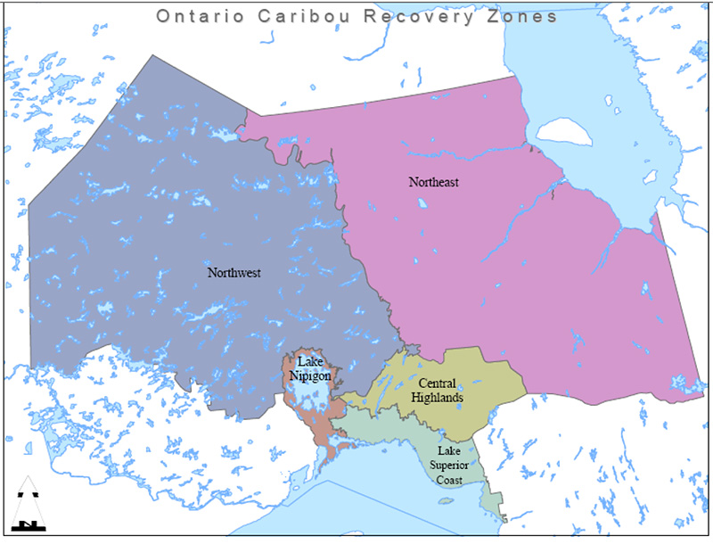
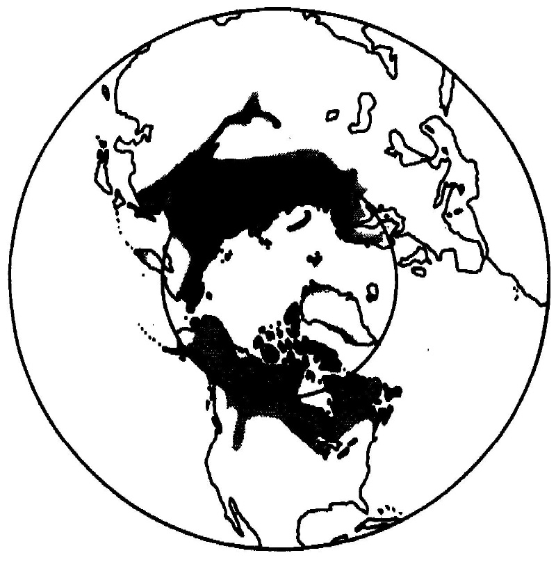
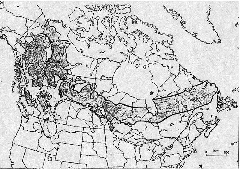
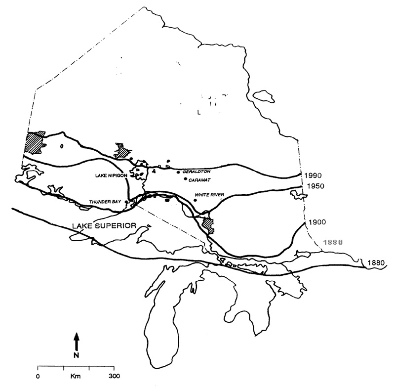
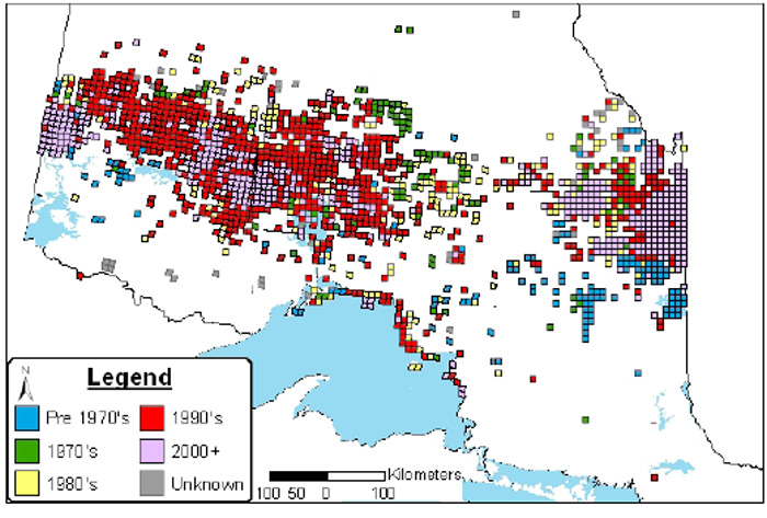
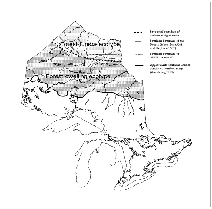
Tables
Table 1. Recommended recovery approaches for achieving woodland caribou recovery objectives in Ontario and their anticipated effects (Immediate implementation of an approach may be necessary to reduce known threats associated with range recession and population decline of woodland caribou).
| Recovery approach number | Priority | Links with Objectives | Recommended Recovery Approach | Anticipated Effects |
|---|---|---|---|---|
| 1 | High | 1,2,3,4,5,6 | Develop a provincial road strategy that considers woodland caribou recovery at landscape and ecoregional scales. | Establishes strategic access planning approaches at a landscape scale to mitigate the effects of roads on woodland caribou movements, distribution and survival. |
| 2 | High | 6 | Develop and implement a definition of habitat for woodland caribou consistent with that developed by the National Boreal Caribou Technical Steering Committee. | Provides standardized working definition for the management and protection of woodland caribou habitat across all jurisdictions. |
| 3 | High | 6 | Develop a comprehensive provincial woodland caribou policy; review every 5-10 years and revise as required. | Establishes strategic provincial direction resulting in improved coordination of resource and land use planning for protection and recovery of woodland caribou populations and habitat. |
| 4 | Medium | 6 | Review existing relevant policies and legislation to determine current level of protection afforded woodland caribou and recommend appropriate improvements. | Identifies and remedies gaps in current legislative and policy tools for woodland caribou conservation in Ontario. |
| 5 | High | All | Review and revise Recovery Strategy on 5 year cycle; report on progress; revise objectives and priorities as required. | Ensures that objectives and implementation priorities remain current. This re-evaluation step is critical to maintaining a Recovery Strategy that is effective under the conditions present at the time. |
| Recovery approach number | Priority | Links with Objectives | Recommended Recovery Approach | Anticipated Effects |
|---|---|---|---|---|
| 6 | High | 7,8,9 | Develop and implement a standardized inventory and monitoring program for provincial woodland caribou range, local populations and ranges; provide training for surveyors; submit data to centralized provincial database. | Establishes standardized methods for collecting range, population and habitat data; allows evaluation of population health and range occupancy for assessing the success of the strategy; provides information for land use and resource management planning. |
| 7 | High | 8 | Create and maintain a centralized provincial database for point, linear and polygon data in a standardized, accessible format for woodland caribou observations and surveys. | Provides a central repository for all woodland caribou data collected in the province; supports population, range and habitat monitoring, evaluation and modeling, as well as policy and legislative development. |
| 8 | High | 5,7 | Develop and maintain a provincial range map of historic and current occupancy utilizing all available verified data; update every 5 years. | Provides a tool to track and report on changes in provincial range and connectivity of populations over time and evaluate recovery actions. |
| 9 | High | 6,7,8,10 | Increase awareness and monitoring of woodland caribou occurrence by promoting and distributing woodland caribou sightings post card. | Provides caribou sightings information that through a validation process can be incorporated into centralized observation databases; increase public awareness and support. |
| Recovery approach number | Priority | Links with Objectives | Recommended Recovery Approach | Anticipated Effects |
|---|---|---|---|---|
| 10 | High | 1,3,4,5,6,9 | Develop and implement a provincial cervid ecological management framework to integrate management decisions for all cervid species. Within this context, species-specific management objectives in association with habitat and landscape management prescriptions for woodland caribou, moose and deer would be collectively established. Objectives for each cervid species would be biologically feasible, with consideration of the least resilient species. | Allows evaluation of risk of prey base changes and risk of predation and transmission of brainworm in areas where deer, moose and woodland caribou range overlap; maintains and restores landscape patterns conducive to maintaining woodland caribou; would ensure no compromise of objectives set for the most “at risk” species. |
| 11 | Medium | 6,10,11 | Work with First Nations, treaty organizations, Tribal Councils and communities to determine the extent of subsistence harvest; if necessary, support development of sustainable harvest strategies by First Nation communities and/or organizations. | Provides more reliable data on subsistence harvest and direct human-caused woodland caribou mortality; enables assessment of human-caused woodland caribou mortality over time. |
| 12 | Low | 7,10 | Establish and implement a monitoring protocol for prevalence, distribution and intensity of brainworm. | Monitors potential threat of brainworm to woodland caribou populations; provides insight relative to informed decision-making regarding translocations. |
| 13 | Low | 1,6,10 | Evaluate the use of translocations as a means for population re-establishment or augmentation; develop criteria and guidance, including risk analysis, for when it would be an appropriate management approach; consider parks and protected areas with high density woodland caribou populations as potential sources for translocations. | Provides an assessment of a tool to aid in population recovery in areas where populations have been extirpated or severely depleted. |
| 14 | Medium | 3,4,6,7,10 | Consider the re-establishment and/or expansion of deer seasons within woodland caribou range as a tool to support woodland caribou recovery, and increase monitoring of white-tailed deer populations in woodland caribou range. | Provides a management option to help manage the potential threat of brainworm, as well as elevated predation levels, to woodland caribou populations; provides data comparable to that collected across deer range to indicate deer population trends in northern WMUs; relates this information to potential threats to woodland caribou population health. Note that there is an anticipated linkage with recommended recovery approach #10. |
| 15 | Low | 6,10 | Evaluate the role of predator management as a potential tool for selective application in support of woodland caribou recovery, including the identification of possible methods (e.g., indirectly via habitat management, directly via sterilization) and situations where each may be considered. Evaluations must also consider predator population status and the effects of management on predator populations. | Will provide for the option of site-specific predator management, if required, to address a situation where a local woodland caribou population is imperiled. |
| Recovery approach number | Priority | Links with Objectives | Recommended Recovery Approach | Anticipated Effects |
|---|---|---|---|---|
| 16 | High | 3,4,5,6 | Incorporate woodland caribou recovery habitat requirements into environmental assessments, review and implementation of significant development proposals, and all federal, provincial, and Aboriginal (and, where applicable, municipal) land use planning initiatives, including consideration of cumulative impacts. | Allows for the identification, protection, provision and restoration of habitat in permitted developments, land use and resource management plans to sustain and recover populations and mitigate potential negative impacts of activities. Monitoring of approaches for effectiveness is required. |
| 17 | High | 1,4,5,6,9 | Undertake a comprehensive land-use planning process for the northern boreal forest north of the current managed forest that incorporates woodland caribou recovery habitat requirements into environmental assessments, implementation of development proposals, and all federal, provincial and Aboriginal and use planning initiatives, including consideration of cumulative impacts. | Incorporates woodland caribou range and habitat requirements in a strategic land-use planning context for the northern boreal forest; allows for the identification, protection, provision and restoration of habitat in permitted developments, land use and resource management plans to sustain and recover populations and mitigate potential negative impacts of activities; requires monitoring of approaches for effectiveness. |
| 18 | High | 3, 4, 6, 10 | Develop and implement supplementary management direction to address cumulative effects of all human developments, and to ensure such development is consistent with the protection of recovery habitat, including access, hydro-electric developments, peat exploration and development, tourism, mineral exploration, mining and other development activities. | Mitigates cumulative effects on local populations of various industrial and social developments associated with land use and resource management plans; ensures the interpretation and application of Landscape, Stand and Site and Silvicultural guides work collectively towards recovery habitat protection. |
| 19 | Medium | 1,2,5,6 | Establish large parks and protected areas located within or adjacent to current or future woodland caribou range within the managed forest and the northern boreal forest; complete park management plans for existing protected areas within or adjacent to current or future woodland caribou range and consider woodland caribou recovery as a primary consideration in those plans; integrate protected areas into planning initiatives for the broader landscape. | Provides refuges from known threats to woodland caribou conservation within the managed landscape, as well as benchmarks to support the monitoring of woodland caribou conservation on the broader landscape; ensures a high priority for management planning is given to protected areas within woodland caribou range to assist in the provision of woodland caribou habitat and recovery; ensures consideration of the role of protected areas in woodland caribou recovery in a landscape context and increases the integration of park management practices with those in the adjacent managed landscape. |
| 20 | High | 3,4,6,11 | Initiate action planning by establishing RIGs for the Lake Nipigon-Central Highlands-Lake Superior Coast, Northwest and Northeast recovery zones, and a Provincial Woodland Caribou Technical Committee to address technical non-geographically-based issues. | Leads to operational recovery planning and implementation; ensures that the Recovery Strategy is translated into actual recovery efforts; and provides a forum for increased public input into woodland caribou recovery. |
| Recovery approach number | Priority | Links with Objectives | Recommended Recovery Approach | Anticipated Effects |
|---|---|---|---|---|
| 21 | High | 5,9,10 | Delineate and describe ranges, range components and local populations within and among recovery zones. | Defines the specific geographic scope of future recovery efforts and the units of land within which the recovery habitat approach will be applied; recognizes the large areas required by woodland caribou to meet their life history requirements and avoid predators, rather than focusing on the identification of discrete landscape elements. |
| 22 | High | 2,3,4,5,6,7 | Develop woodland caribou range management plans for all delineated woodland caribou ranges. | Allows for integration of woodland caribou habitat approaches for a variety of linked initiatives at a range of scales; provides linkages with ecoregional targets (e.g. Landscape Guide). |
| 23 | High | 1,2,3,4,5,6 | Consider and adopt approaches to effectively protect woodland caribou and its habitat. | Ensures appropriate protection for woodland caribou and its habitat which is critical to recovery. |
| 24 | Medium | 5,10,11 | Initiate and establish relationships with provinces of Manitoba and Quebec to delineate ranges of local populations shared with Ontario. Establish management protocols to contribute collectively to habitat protection where ranges cross jurisdictional boundaries. | Continues and formalizes existing relationships; acknowledges mutual interests of woodland caribou conservation across jurisdictional boundaries and provides for joint responsibility for sustainability of shared local populations. |
| 25 | High | 5,6,9,10 | Develop and test spatial and non-spatial habitat suitability models using existing woodland caribou and landscape data sets (and further data as they become available); identify ranges and current and future range components; utilize model outputs for land use and resource management planning. | Allows for the identification of existing and future habitat tracts, landscape linkages and rehabilitation areas, in order to devise appropriate and effective land use and resource planning strategies to support recovery within ranges. |
| 26 | High | 2,5 | Emulate natural disturbances and landscape patterns in resource management and land use planning to maintain woodland caribou, moose and other boreal species on the boreal forest landscape within the range of natural variation. | Reduces the risk of range loss due to habitat loss and landscape fragmentation, as well as increased predation due to changes in the landscape caused by human activities. |
| 27 | High | 1,5,6,9 | Develop specific guidance to protect recovery habitat (ranges and range components) through development and implementation direction associated with provincial Landscape, Stand and Site, and Silviculture forest management guides. | Provides direction and guidance to identify and provide habitat in forest management plans and contribute to local population recovery; includes specific direction to integrate decisions from the stand level through to forest landscape level so that range integrity is provided through time. |
| 28 | High | 1,6,9 | Provide input into the review of provincial and regional fire strategies in the interest of maintaining current or creating future woodland caribou range; provide input on future fire management planning in protected areas; provide input on annual fire response values identification and priority setting process. | Ensures habitat requirements for woodland caribou are recognized in provincial fire management strategies; allows for strategic creation of new habitat (e.g. disturbance events) and protection of key habitat tracts, as appropriate. |
| 29 | High | 1,3,4,5,6,7 | Develop silvicultural strategies within forest management plans to ensure linkages between woodland caribou habitat conservation needs and required future forest stand conditions. | Recognizes silvicultural follow-up after logging is recognized as equally as important as landscape pattern to the long-term maintenance of woodland caribou, in managed forests. |
| 30 | High | 1,2,3,4,5,6,7 | Ensure that resource management and other development proposals within woodland caribou range consider and mitigate the potential effects of roads, both their location and use, on woodland caribou habitat values. | Ensures that the direct and indirect effects of roads on woodland caribou are considered and mitigated; ensures that where roads are required, they are located in ways that least fragment the landscape and have least harmful effect upon woodland caribou habitat and habitat use. |
| Recovery approach number | Priority | Links with Objectives | Recommended Recovery Approach | Anticipated Effects |
|---|---|---|---|---|
| 31 | High | 2,9,10 | Identify populations and metapopulations based on genetics, movement and ecological considerations. | Allows for the refinement of recovery zones and associated strategies; enables identification of geographic linkages and barriers between populations; provides information for comparisons with adjacent forest-tundra populations. |
| 32 | High | 1,5,9 | Investigate the effectiveness of forest management, silvicultural, tourism and other resource and land use planning guidelines for conserving woodland caribou habitats and populations. | Provides information for improving guidelines to support recovery by mitigating the effects of human activities. |
| 33 | Medium | 9,10 | Investigate the socio-economic implications of action plans that arise out of the implementation of the strategy. | Provides an analysis of the effects of the proposed strategy and insight into potential opportunities for mitigative measures. |
| 34 | High | 3,4,10 | Develop and test hypotheses to clarify and quantify threats and biologically limiting factors. | Improves understanding of cause and effect relationships of woodland caribou decline; provides science-based information for improving land use and resource management to minimize threats and the effects of limiting factors. |
| 35 | Low | 7,10 | Conduct population viability analysis modeling to assess the cumulative effects of direct and indirect threats to persistence to local populations and recovery zones. | Informs the development of population performance measures, disturbance thresholds and management priorities for recovery zones. |
| Recovery approach number | Priority | Links with Objectives | Recommended Recovery Approach | Anticipated Effects |
|---|---|---|---|---|
| 36 | High | 6,11 | Develop partnerships with Aboriginal communities and organizations within woodland caribou recovery range to share information on woodland caribou ecology and significance to Aboriginal peoples, obtain input on woodland caribou recovery, and implement recovery actions. | Improves understanding of historic and current reliance on woodland caribou by Aboriginal peoples, historic range and habitat use; establishes partnerships for woodland caribou recovery efforts with First Nations. |
| 37 | High | 11 | Develop and implement a provincial woodland caribou communications strategy. | Increases awareness of the ecology and status of woodland caribou; builds public and organizational support for recovery. |
| 38 | High | 11 | Disseminate knowledge on woodland caribou recovery needs to agencies and groups with responsibility for land use or resource management planning within or adjacent to woodland caribou range (e.g. forest management planning teams, local citizens committees, Ministry of Northern Development and Mines, etc.). | Promotes increased awareness of decision-making agencies; supports adoption of effective, efficient, coordinated actions to protect and recover woodland caribou in planning initiatives. |
| 39 | Medium | 7,11 | Continue to liaise and share data with national and provincial agencies involved with woodland caribou management and recovery. | Promotes coordination of woodland caribou management and conservation with other provincial and national agencies. |
| 40 | Medium | 11 | Encourage development of woodland caribou interest groups (e.g. “Friends of” organizations) and partnerships. | Provides further opportunities to increase awareness, support and resources for woodland caribou conservation; leads to involvement of the public which is considered one indicator of Recovery Strategy success. |
| 41 | Medium | 11 | Integrate woodland caribou recovery activities with other boreal species at risk recovery initiatives, such as development and implementation of the Recovery Strategy for Wolverine in Ontario. | Ensures consistent approaches to boreal forest conservation; provides for synergy in recovery efforts. |
2. Descriptions of proposed recovery zones for woodland caribou in Ontario and their anticipated roles in achieving the recovery goalfootnote 7
- Northwest Recovery Zone (NWRZ)
footnote 8 - Includes portions of currently occupied range in ecoregions 2W, 3S, 3W and 4S. The northern boundary of this zone is defined as the southern boundary of WMUs 1A and 1B. The southern boundary is primarily defined by the southern boundary for the caribou habitat tract mapping as identified in forest management plans. Forest management and historical land use pose significant challenges to caribou recovery. Major ecological factors include the drier boreal climate, a shorter fire interval regime, large expanses of bedrock-dominated terrain and large areas of northern forest not yet allocated for forest management. This zone includes the western portion of the zone of continuous range occupancy, and it is important to retain healthy caribou populations, sustainable habitat supply, and habitat connectivity both across the recovery zone and with adjacent recovery zones to the east and south.
- Northeast Recovery Zone (NERZ)
footnote 8 - Includes portions of currently occupied range in ecoregions 2E and 3E. The northern boundary of this zone is defined as the southern boundary of WMUs 1A and 1B. The southern boundary is defined firstly by the southern boundary for the caribou habitat tract mapping as identified in forest management plans. Where habitat tract mapping is not available, the southern boundary is defined by a combination of ecoregion, physical features, including established road networks and intensive forest harvesting, and includes the zone of range occupancy. Forest management and historical land use pose significant challenges to caribou recovery. Major ecological factors include the moist boreal climate, large expanses of boreal wetlands associated with the Hudson Bay Lowlands and portions of the typically boreal clay plain, much of which is not yet allocated for forest management. This zone includes the eastern portion of the zone of continuous range occupancy, and it is important to retain healthy caribou populations, sustainable habitat supply, and habitat connectivity both across the recovery zone and with adjacent recovery zones to the west and south.
- Lake Superior Coast Recovery Zone (LSCRZ)
- Includes ecodistricts 3W5 and 3E4 inclusive of the shoreline and adjacent islands of Lake Superior from Wawa to Nipigon, including Michipicoten Island Provincial Park, Slate Islands Provincial Park, Pic Island and the Rossport Islands. The majority of caribou in this zone reside within provincial or national parks and/or on islands. These populations, particularly those of Pukaskwa National Park, appear to be resilient. To ensure long-term caribou survival, landscape linkages will be required to enable animal movement and genetic exchange. Populations such as those in Slate Islands and Michipicoten Island provincial parks may play a role as donor populations (as Slate Islands caribou have done in the past) should suitable recovery habitat become available and not be recolonized by adjacent resident populations.
- Lake Nipigon Recovery Zone (LNRZ)
- Includes ecodistrict 3W3 including all of Lake Nipigon and shoreline, and the Nipigon River south to Lake Superior, the Black Bay Peninsula and St. Ignace Island and environs in Lake Superior. Boundaries are based on existing calving activity and potential on the Lake Nipigon islands. Although there is significant human activity in the southern part of this zone, it remains a key bridge connecting isolated populations and habitat along the north shore of Lake Superior with populations within continuous range. It is surrounded on the north by the Northwest Recovery Zone, and with it forms part of continuous caribou range.
- Central Highlands Recovery Zone (CHRZ)
- Comprises portions of ecodistricts 3E2, 3E4 and 3W4, covers the area lying south of the Northwest and Northeast recovery zones, and links with the Lake Superior Coast Recovery Zone to the south and the Lake Nipigon Recovery Zone to the west. This zone represents range formerly occupied by caribou, but within which only scattered sightings of caribou have been reported (e.g., Nagagami Lake, Hillsport, Hornepayne, etc.) over the last couple of decades. A small number of caribou are believed to be permanently resident within this recovery zone. It represents an important landscape for potentially linking the Lake Superior shoreline populations to the continuous range of the Northeast and Northwest recovery zones.
| Category | Anticipated Challenge(s) |
|---|---|
| Implications of caribou recovery to wood supply and forest management |
|
| Implications of caribou recovery to the mining industry |
|
| Implications of caribou recovery to the tourism industry |
|
| Effects of tourism and other human activity on caribou |
|
| Implications of caribou recovery to other wildlife management concerns |
|
| Implications of caribou recovery to angling and hunting opportunities |
|
| Implications of access on recovery |
|
| Communications and awareness |
|
| Community concerns |
|
| First Nations Involvement |
|
| Ability to measure the success of caribou recovery |
|
| Linkages with other planning initiatives |
|
| Initiative | Linkage | Geographic scope |
|---|---|---|
| Crown Forest Sustainability Act | Provides strategic direction for forest management planning | Managed forests on Crown land |
| Endangered Species Act Legislative Review | Considering expansion of protection provisions to threatened species and their habitats; currently only endangered species are eligible for protection under the act | Province |
| Far North Planning Initiative | Land use planning | North of current managed forest |
| Lake Superior Bi-national Program | Support land use planning efforts to protect habitat and populations | Lake Superior basin in Canada and US |
| Landscape, Stand and Site Guides for Forest Management Planning (under development) | Provides direction for forest management planning | Managed forests on Crown land |
| Mineral exploration and development | Consider potential implications (e.g. increased access and associated human disturbance) to caribou recovery | Across northern boreal forest |
| National Marine Conservation Area | Protected areas establishment | North shore of Lake Superior |
| National Technical Committee [for boreal woodland caribou] |
| Canada-wide |
| Northern Boreal Initiative | Collect habitat and population information | North of the current managed forest |
| Ontario Wolverine Recovery Strategy (under development) | Integrate woodland caribou and wolverine recovery actions | Across northern boreal forest |
| Ontario-Manitoba hydroelectric transmission corridor | Consider potential landscape-level implications (e.g. landscape-level fragmentation, changes in caribou mortality) to caribou recovery | Across northern boreal forest |
| Permanent all-weather road establishment to all northern First Nation communities | Consider potential implications (e.g. landscape-level fragmentation, changes in caribou mortality) to caribou recovery | Across northern boreal forest |
| Provincial Cervid Ecological Management Framework (under development) | Hierarchy of wildlife management decisions to incorporate caribou conservation considerations | Province |
| Room to Grow Policy | Protected areas establishment | Managed forests on Crown land |
| Water and wind power development and expansion | Consider potential implications (e.g. increased access and associated human disturbance) to caribou recovery | Across northern boreal forest |
| Whitefeather Forest and Adjacent Areas Land Use Strategy implementation and the associated environmental assessment process for forest management planning | Will provide future direction for forest management planning | North of current managed forest |
Appendices
Approaches to recovery zone management and habitat conservation
These appendices are intended to assist with the development of action plans for each of the 5 recovery zones described in Section 4.1 and Table 2, and to provide more detail on the hierarchical approach to habitat conservation described in Section 4.2. Appendix A-1 outlines a framework for a hierarchical approach to recovery habitat conservation. In creating the recovery zones, the Recovery Team recognized differing opportunities and constraints to achieving the goal and objectives of the Recovery Strategy. These differences relate to the variation in landscape ecology, caribou distribution and the history of human uses across caribou range in northern Ontario. Appendix A-2 links strategic principles and specific components of the recovery goal to each recovery zone. Appendix A-3 indicates specific measures that RIGs may include in their action plans for each recovery zone.
Appendix A-1. Framework for a hierarchical recovery habitat conservation approach for forest-dwelling woodland caribou in Ontario
Habitat scale: Range
- Delineation/Definitional Criteria
- Large landscape unit that encompasses at least the known or inferred local population, or the portion of the boreal forest landscape within which a local population is to be sustained (diffuse and/or wide ranging populations on dynamic landscapes). Delineation and size consistent with local population sustainability objectives and landscape dynamics.
- Habitat functions provided at this scale
- Sustainable habitat supply to satisfy all life requirements of local populations over multiple generations, including provision of present suitable habitat, future habitat and alternate habitats; adequate space for predator avoidance strategies to operate.
- Activities likely to result in destruction or degradation of habitat
- Failure to provide for future habitat or alternate habitats to account for temporal and spatial dynamics of the landscape (fire, logging, succession); large human "footprint" contributing to increased predator numbers or hunting efficiency; landscape arrangement that reduces ability of caribou to evade predators or avoid predator encounters.
- Example measures contributing to effective protection
- Manage present and future forest cover and composition to ensure an adequate and sustainable supply of seasonal and year-round habitat. Strategically plan access and linear feature development to avoid present and anticipated high use areas or seasonal ranges. Define and manage towards a habitat planning target across the range that allows for achievement of desired local population response. Ensure number, spatial arrangement and timing of resource development, extraction and human activities are appropriate to manage risk at pre-defined levels.
- Comments
- Represents recovery habitat. Includes land and water area providing for present and future local population objectives. Provides context for conservation decisions regarding Seasonal Ranges, High Use Areas and Calving Sites. Suggests range-specific evaluation of threats and opportunities required to determine acceptable level and extent of industrial activities. Also suggests management through a range management plan. Caribou habitat values met within a managed and dynamic forest condition where present and future seasonal ranges and high use areas are sustained. May include dedicated protected areas, commercial forest or some combination of the two. General approach consistent with concepts proposed for Landscape Guide.
- Example data types to support delineation or effective protection
- Current and historical occurrence. Quantitative and/or qualitative descriptions of seasonal or year-round habitat. Local population demographics. Decision support models linking local population response to habitat thresholds or minimum viable populations. Forest dynamics parameters.
Habitat scale: Seasonal ranges
- Delineation/Definitional Criteria
- Component of range typically described as winter range or summer range but may also include specific travel linkages or spring/fall transition habitats. Usually associated with predictable landform, topographic, or hydrological landscape features and forest cover or compositional criteria.
- Habitat functions provided at this scale
- Provides for predator avoidance and forage availability best suited for specific seasonal life requirements. Large and diverse enough to provide for alternate habitat selection attributable to different levels of seasonal stress such as very severe seasonal weather patterns (precipitation, snow depth, crusting, etc.) or direct human or predator harassment.
- Activities likely to result in destruction or degradation of habitat
- Less area in suitable vegetative condition (age class, patch size, spatial arrangement and species composition) than required to provide effective refuge or forage required for the number/density of animals using the range, or the number of animals that must use this range in order to have a self-sustaining population. Harvest scheduling or silvicultural approaches inconsistent with achievement of future seasonal habitat requirements.
- Example measures contributing to effective protection
- Promote seasonal range conservation through protective measures such as fire suppression; precautionary allocation (forest management/mineral exploration) and avoidance of adjacent development activities that may encourage habitat for alternate prey species or otherwise increase the relative abundance, distribution or mobility of predators within or near seasonal ranges. Manage density and rehabilitation of linear features that may increase predator mobility. Ensure forest management practices such as harvest, renewal and tending are consistent with short and long term objectives for renewal of effective seasonal ranges and their habitat components.
- Comments
- Seasonal ranges may or may not exist for some local populations or within some ranges. Where they do exist, they tend to be more dynamic in space and time than the overall range depending on the specific biological functions being provided. These areas are generally suitable for current use and typically receive more precise prescriptions for conservation or management than that portion of the range between seasonal habitats. Future planning will require a strong and consistent link between Landscape, Stand and Site and Silviculture Guide with respect to creating future seasonal ranges (suitable forest attributes).
- Example data types to support delineation or effective protection
- Seasonal caribou distribution and habitat use surveys. Telemetry or satellite tracking studies. Habitat selection functions. Land suitability and capability assessments.
Habitat scale: High use areas
- Delineation/Definitional Criteria
- Component of a range or seasonal range regularly exhibiting higher than expected use, likely associated with especially desirable or effective habitat features such as forage or the absence of human, insect or predator harassment.
- Habitat functions provided at this scale
- Nursery or calving areas facilitate summer calf survival by providing refuge from predation in the vicinity of forage resources during this high risk period. Any reduction in calf mortality or improvement in body condition prior to winter will increase probability of recruitment into the local population. High use winter areas may provide high abundance or quality of forage, or efficient access to refuge or forage during extreme weather conditions. Usually associated with forest conditions that provide abundant lichen, less snow and/or good visibility.
- Activities likely to result in destruction or degradation of habitat
- Human disturbance that forces cows and calves to become separated, forces cows with calves into unnecessary movement (increases potential for predator encounters) or displaces cows with calves into higher risk environments. Habitat alteration that increases actual or potential predator activity in the vicinity of winter or summer High Use Areas including food subsidies; forest management practices that create and maintain high diversity, browse-rich or early seral stage forests; reduction or elimination of forage values due to changes in forest stand composition, structure or spatial arrangement. These changes may result from forest harvesting, natural disturbance (fire, blowdown, insects and disease) or from forest plant succession. Infrastructure or human activity that displaces caribou away from resources or into areas of greater predation risk. Any infrastructure development (roads/trails) that encourage or increase efficiency of predator activity in or around High Use Areas.
- Example measures contributing to effective protection
- Encourage direct or indirect forest management or access management practices in and around nursery areas that discourage predator numbers or hunting efficiency, enhance the ability of caribou to detect and escape from predators or enhance forage abundance. Avoid factors that accelerate decline, deterioration, reduction of the habitat attributes that make High Use Area desirable. Avoid linear corridor development into or adjacent to present and potential High Use Areas. Manage human activities, including research activities, to minimize displacement of caribou.
- Comments
- Many High Use Areas may be used some years but not others or for various times within a year depending on other environmental conditions. Degree of use may vary with extent or intensity of weather, disturbance or other events. Use may be related to quality of neighboring habitats or range components. Warrants management prescriptions with high degree of protection/conservation consistent with the expected or planned dynamics of the range and the type and magnitude of threats to the local population.
- Example data types to support delineation or effective protection
- Seasonal caribou distribution and habitat use surveys. Telemetry or satellite tracking studies. Habitat selection functions. Documentation of repeat caribou use. Land capability assessments. Vegetation dynamics.
Habitat scale: Calving sites
- Delineation/Definitional Criteria
- Typically small, discrete geographic unit with demonstrated evidence of repeat successful calving activity. May include islands, peninsulas or other specific topographic features.
- Habitat functions provided at this scale
- Provides for effective predator avoidance during parturition and vulnerable early calf development period. Expected to be very important from birth until calf is fully mobile and can travel freely with cow. Broader refuge values are provided by the Nursery Area.
- Activities likely to result in destruction or degradation of habitat
- Human infrastructure or activity that could displace cows before or during calving or cows with calves in early parturition period. Recreational activity, food subsidies, campsites, shore lunch fish cleaning locations that could attract predators; alteration of vegetative cover (succession, harvest, fire) that might cause cows to select a higher risk environment for calving.
- Example measures contributing to effective protection
- Prohibition of alteration to forest cover, human disturbance/activities during high risk period, or human infrastructure development within a functionally effective radius.
- Comments
- Many calving sites may occur within broader Nursery Areas and must be considered within the context of their respective Nursery Area. Very high level of precautionary principle is applied at this scale. If a functioning and repeat-use Calving Site, then prohibitions to development and human use may be in order. Functionally analogous to "residence" under SARA.
- Example data types to support delineation or effective protection
- High fidelity summer use by cows between 2 weeks before or 4 weeks after expected calving period. Proof of calving desirable but not necessary for delineation of value.
Appendix A-2. Proposed preliminary objectives and strategic principles for application of the recovery habitat conservation approach for each of the 5 recovery zones proposed for Ontario.footnote 10
| Recovery Zone | Preliminary Objective | Strategic Principles |
|---|---|---|
| Northwest and Northeast | Maintain self-sustaining genetically connected forest-dwelling woodland caribou populations where they currently exist. |
|
| Lake Superior Coast | Ensure security of individual populations from extirpation. Ensure (reproductive) connections among currently isolated mainland populations. |
|
| Lake Nipigon | Applies to all aspects of the goal statement. Prevent further isolation of individual populations and ensure security from extirpation. |
|
| Central Highlands | Ensure security of individual populations from extirpation. Ensure (reproductive) connections among currently isolated mainland populations. |
|
Appendix A-3. Potential caribou population and habitat evaluation measures for specific recovery zones.footnote 11
| Recovery zone | Evaluation measures |
|---|---|
| Central Highlands Recovery Zone |
|
| Lake Nipigon Recovery Zone |
|
| Lake Superior Coast Recovery Zone |
|
| Northwest and Northeast Recovery Zones |
|
Footnotes
- footnote[1] Back to paragraph Former recovery team member
- footnote[2] Back to paragraph There are two ecotypes of caribou in Ontario: forest-dwelling and forest-tundra. Forest-tundra caribou have been assessed as not-at-risk and are not addressed in this Strategy. Henceforward, the terms "woodland caribou" or "caribou" will refer to the forest-dwelling ecotype. Irrespective of forest type, all forest-dwelling woodland caribou in Ontario belong to the boreal population.
- footnote[3] Back to paragraph A group of boreal caribou occupying a defined range. This is the basic unit of conservation and management for woodland caribou recovery planning.
- footnote[4] Back to paragraph A broad geographical area used and/or required for a self-sustaining local population of woodland caribou and providing for both present and future habitat needs.
- footnote[5] Back to paragraph For the purposes of this recovery strategy, recovery habitat for woodland caribou is defined as equivalent with caribou ranges.
- footnote[6] Back to paragraph "Any alteration to the topography, geology, soil conditions, vegetation, chemical composition of air/water, surface or groundwater hydrology, microclimate or sound environment of such magnitude, intensity, or duration which significantly reduces the capacity of the habitat to contribute to the survival or recovery of the species at risk, based upon the biology of that species and as expressed in the approved recovery strategy/action plan" (Environment Canada 2004).
- footnote[7] Back to paragraph Ecodistricts and ecoregions based on Crins et. Al. (2006)
- footnote[8] Back to paragraph Northeast and Northwest recovery zones are based upon ecodistrict boundaries, not administrative ones.
- footnote[9] Back to paragraph Challenges as identified by public and user groups.
- footnote[10] Back to paragraph Proposed by the Ontario Woodland Recovery Team for consideration by RIGs responsible for action plan development.
- footnote[11] Back to paragraph These are in addition to measures recommended for application in all recovery zones (as per section 6.0).