Birds and bird habitats: guidelines for windpower projects
This guideline provides guidance on identifying and assessing bird habitat and addressing potential negative effects on birds and bird habitats during the planning construction and operation of onshore wind power projects in Ontario.
1.0 Introduction
The Green Energy Act, 2009 places a priority on expanding Ontario’s use of clean and renewable sources of energy such as wind, water, solar and bioenergy. Developing these resources is a cornerstone of the province’s plan to reduce the impacts of climate change and to build a greener economy for Ontario.
A key element of the Green Energy Act is a coordinated provincial approval process for renewable energy projects. This new process integrates into one process all provincial Ministry requirements for the review and decision making on proposed renewable energy generation facilities. The requirements are outlined under the Ministry of the Environment’s Renewable Energy Approvals Regulation (O.Reg. 359/09) and the Ministry of Natural Resources’ (MNR) Approval and Permitting Requirements Document for Renewable Energy Projects.
The Renewable Energy Approvals Regulation describes the requirements for wind power projects related to significant natural features, including significant wildlife habitat. Birds are important to Ontario’s biodiversity, and their habitats are identified as significant wildlife habitat (SWH) under the ministry’s Significant Wildlife Habitat Technical Guide.
This Guideline provides guidance on identifying and assessing bird habitat and addressing potential negative effects on birds and bird habitats during the planning, construction, and operation of onshore wind power projects in Ontario. This Guideline supports the Renewable Energy Approvals Regulation and is applicable to both Crown and private land.
1.1 Potential effects of wind power projects on birds
Bird mortality monitoring results from Ontario wind power projects are consistent with studies undertaken around the world. These studies identify that relatively low numbers of bird fatalities occur at Ontario wind power projects. Ontario results show that approximately 2.5 birds per year are killed by individual wind turbines. At current mortality levels, wind power projects are not a sustainability concern for most of Ontario’s bird populations.
The Renewable Energy Approvals Regulation and this Guideline focus on consideration and protection of bird SWH when selecting a project location. This habitat-based approach appears to be a key factor in preventing negative effects on birds and bird habitats. However, some knowledge gaps remain relating to disturbance, avoidance and bird migration.
This Guideline will assist in identifying and addressing concerns associated with bird SWH and interactions between wind turbines and birds and bird SWH, and contribute toward an adaptive management approach to protecting birds and bird habitats.
To this end, the Wind Energy Bird and Bat Monitoring Database for bird and bat data associated with wind power projects has been collaboratively established by the ministry, the Canadian Wind Energy Association, Environment Canada - Canadian Wildlife Service, and Bird Studies Canada. The intent of this database is to facilitate an improved understanding of the effects of wind turbines on birds and bats, and to allow for greater consistency in assessment of wind power effects.
Wind power projects have the potential to affect birds directly (i.e. collision mortality) and indirectly (i.e. disturbance and avoidance). Direct and indirect effects of potential wind power projects on birds and bird habitats are outlined below. A detailed summary of potential effects of wind power projects on birds can be found in Wind Turbines and Birds: A Background Review for Environmental Assessment (EC-CWS, 2007a).
Direct effects
Birds may be injured or killed through collisions with turbine blades and towers, guy wires, meteorological towers, and maintenance vehicles. In nocturnal birds, mortality may also arise from physical exhaustion associated with light-induced disorientation.
Three main factors contribute to avian mortality at wind power projects:
- density of birds in the area and their behaviours (e.g. flight displays, feeding, etc.);
- landscape features in the area (especially ridges, steep slopes, valleys and landforms such as peninsulas and shorelines that funnel bird movement); and
- poor weather conditions.
Appropriate selection of a project location is a key factor in preventing potential negative effects on birds.
Indirect effects
Indirect effects on bird habitat and behaviour are also important when considering potential adverse effects of wind power projects. Birds may be displaced from suitable habitat by wind power projects at any stage in their annual cycle (e.g. breeding, migration). Displacement may be due to direct loss of feeding, breeding, or migratory stopover habitat during construction and operation of a facility, or to active avoidance of structures, human activity, noise, or infrastructure (e.g. roads, cut forest edges). Quality of breeding habitat may also be diminished by fragmentation effects (e.g. openings in contiguous habitat to accommodate turbines, transmission lines, and service roads) that may lead to changes in predation and parasitism levels or to adverse effects on area-sensitive species. The extent of avoidance behaviour is species-specific, and may lead to reduced energy intake through lost feeding opportunities.
1.2 Regulatory framework
The Renewable Energy Approvals Regulation establishes requirements to ensure the specific protection of significant natural heritage features, including bird significant wildlife habitat. The Renewable Energy Approvals Regulation establishes study requirements for natural features, development prohibitions and setbacks from bird SWH, and establishes the requirement for the preparation of an environmental effects monitoring plan for birds. In accordance with section 24.(2) of the Renewable Energy Approvals Regulation, the applicant must use evaluation criteria or procedures established or accepted by the ministry in undertaking work related to significant wildlife habitat, and under section 23.1(2) they must prepare the environmental effects monitoring plan for birds in accordance with this Guideline.
This Guideline establishes the criteria and procedures for Class 3 and 4 wind power projects to fulfill the requirements related to birds and bird habitats established in the Renewable Energy Approvals Regulation including:
- the process, as part of the Natural Heritage Assessment, for identifying bird habitats and determining whether they are significant wildlife habitats that require protection under the Renewable Energy Approvals Regulation;
- the identification of potential negative effects on bird SWH, specific mitigation to be applied, and environmental effects monitoring for habitat as part of an environmental impact study; and
- Post-construction Environmental Effects Monitoring Plan requirements for potential negative environmental effect on birds (i.e. operational mortality) and additional monitoring and/or mitigation in the event that the monitoring indicates a negative environmental effect occurring at a level that exceeds the significant annual mortality threshold.
1.3 Ministry of Natural Resources role
The ministry is responsible for establishing or accepting evaluation criteria and procedures related to natural features, including bird habitat. Under section 28 of the Renewable Energy Approvals Regulation, the applicant must submit all reports to MNR related to the Natural Heritage Assessment and the Environmental Effects Monitoring Plan for birds. The ministry is responsible for reviewing the reports and will provide written confirmation when the applicant has conducted their Natural Heritage Assessment in accordance with the ministry criteria and procedures and may provide any additional comments in writing to the applicant. The ministry is also responsible for providing the applicant with comments on the Environmental Effects Monitoring Plan for birds. The ministry confirmation and comments are required under section 28.(3) of the Renewable Energy Approvals Regulation, submitted as part of an application to the Ministry of the Environment for a Renewable Energy Approval.
The ministry’s Natural Heritage Assessment Guide for Renewable Energy Projects provides procedures and evaluation criteria for conducting Natural Heritage Assessments and may provide additional procedural guidance relevant to the consideration of bird habitat.
Environment Canada is the federal agency responsible for protection of migratory birds through the administration of the Migratory Birds Convention Act and has responsibilities under the federal Species at Risk Act. During a federal environmental assessment under the Canadian Environmental Assessment Act, Environment Canada will provide advice on migratory birds, federal species at risk (including special concern) and other areas related to its mandate. Where the Canadian Environmental Assessment Act is not triggered, the ministry advises the applicant to seek migratory bird advice from Environment Canada.
The ministry has a responsibility for protecting the habitat of all bird species (migratory and non-migratory) in Ontario. Applicants will be able to more readily advance their projects by working closely with the ministry and Environment Canada to ensure that all bird and bird habitat information is identified and assessed
Provincially protected/managed birds are the mandated priority for the ministry, including:
- game birds listed in Schedule 3 of the Fish and Wildlife Conservation Act;
- specially protected species (raptors) listed in Schedule 7 of the Fish and Wildlife Conservation Act;
- specially protected species (other than raptors) listed in Schedule 8 of the Fish and Wildlife Conservation Act;
- all non-migratory bird species; and
- all species listed under the Endangered Species Act (2007).
This Guideline is not intended to replace any species-specific approaches that may be needed to comply with the Endangered Species Act. More information regarding the Endangered Species Act and how to identify locations for protected bird species and their habitats can be found in Appendix B of the ministry’s Approval and Permitting Requirements Document for Renewable Energy Projects and by contacting a local ministry office.
2.0 Assessment process for birds and bird habitats
As part of the Natural Heritage Assessment and required by the Renewable Energy Approvals Regulation, wildlife habitat, including bird habitat, must be considered and addressed. Reports associated with the Natural Heritage Assessment and Environmental Effects Monitoring Plan for birds must be submitted to the ministry. Applicants must prepare the following reports and plans:
- Records Review Report;
- Site Investigation Report;
- Evaluation of Significance Report (if applicable);
- Environmental Impact Study (EIS) Report (if applicable; including a description of mitigation and monitoring outlined in the Construction Plan Report and Environmental Effects Monitoring Plan); and
- Environmental Effects Monitoring Plan (all projects).
These reports and associated submission procedures are described in the Renewable Energy Approvals Regulation and Natural Heritage Assessment Guide for Renewable Energy Projects. The reports should provide information on pre-construction assessment and mitigation options, including: maps, field protocols, survey methods and criteria for mitigation implementation. If an EIS is required and mitigation is implemented to reduce the effects of the project on significant bird habitat, habitat-based monitoring is required, and will be outlined in the Environmental Effects Monitoring Plan.
The Renewable Energy Approvals Regulation requires that all bird monitoring data and associated reports to be consistent with the ministry’s procedures and protocols, and requires that applicants submit these data and reports to the Ministry of the Environment. This Guideline identifies that monitoring data and reports must satisfy the data standards and requirements of the Wind Energy Bird and Bat Monitoring Database. Bird survey data submitted will be entered into the database, analyzed, reported and used to address knowledge gaps and create data summaries.
Due to the potential negative environmental effects on birds from the operation of wind power projects, 3 years of annual post-construction bird mortality monitoring is required for all projects. This monitoring will be set out in the Environmental Effects Monitoring Plan. Should post construction monitoring show significant bird mortality (Section 4.1), operational mitigation may be required.
Figure 1 outlines the assessment process for identifying and evaluating bird habitat, addressing the potential negative effects to birds and their habitats and minimizing and monitoring of potential effects. At each stage of the assessment, applicants evaluate new information as it becomes available to identify candidate and confirmed significant wildlife habitat, develop mitigation measures and direct monitoring efforts. This process can be coordinated with the approach used to assess and evaluate potential impacts to bats.
Figure 1. Bird and bird habitat assessment process (as part of Natural Heritage Assessment)
Consultation with the ministry is recommended to ensure work is undertaken in a manner consistent with ministry guidelines and to assist in project review.
Applicants may choose to modify the project location as information becomes available during the natural heritage assessment or other requirements for relevant approvals.
- Project location
- Records review
- Site investigation
Options: Apply setback or Evaluate. If not significant, no setback, proceed to Environmental Effects Monitoring Plan.- Evaluation of significance
Options: Apply setback or Evaluate. If not significant, no setback, proceed to Environmental Effects Monitoring Plan.- Environmental impact study
- Environmental effects monitoring plan
- Three year post-construction monitoring
- No bird mortality/habitat concerns?
- No further action required
- Bird mortality/habitat concerns?
- Operational mitigation and/or additional monitoring
- No bird mortality/habitat concerns?
- Three year post-construction monitoring
- Environmental effects monitoring plan
- Environmental impact study
- Evaluation of significance
- Site investigation
- Records review
2.1 Project location
Selecting the location for the project is generally the most important consideration to minimize potential effects to birds and their habitats. Applicants should collect and consider all available bird and bird habitat-related information relevant to the proposed project location.
Landscape features in the area (especially ridges, steep slopes, valleys and landforms such as peninsulas and shorelines that funnel bird movement) may increase the risk associated with bird mortality at a wind power project.
2.2 Records review
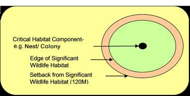
The applicant will ensure that a search for and analysis of records are conducted in respect of the air, land and water within 120 metres of the project location, as set out in the Renewable Energy Approvals Regulation. Wildlife habitat data collected during the records review will frequently identify habitat components (e.g. nest/colony), which appear as points on a map. While these habitat components may originate further than 120 metres from the project location, the associated candidate or confirmed significant wildlife habitat (Figure 2) can extend well beyond the point location itself (in some cases as much as 1000 metres). Applicants should consider and identify habitat components and associated wildlife habitat that may extend to or within 120 metres of the project location during the records review.
During the records review stage of the Natural Heritage Assessment, applicants will collect all available bird and bird habitat-related information for the proposed project location, including information on bird species, candidate and confirmed bird SWH and other relevant data. The ministry will provide the applicant with any known bird information relevant to the project and encourages consideration of additional sources of information (Appendix C). Information collected during the Records Review stage should be confirmed or verified during the Site Investigation and during the Evaluation of Significance (where applicable). In most cases, much of the required detailed project location information will be collected during the Site Investigation and Evaluation of Significance stages.
Bird and bird SWH related information should be collected as early as possible to expedite the Natural Heritage Assessment and renewable energy approvals process.
Records review information will generally include:
- species present (or likely) and relevant life cycle/history characteristics;
- information on any confirmed SWH;
- information on features associated with candidate SWH (e.g. wetlands, ridges, woodlands, major water bodies); and
- habitat types (e.g. Ecological Land Classification)
- other natural heritage features in near proximity to the proposed development
- potential feeding, migration, roosting and nesting areas
- information on species protected under the ESA 2007
- proximity to areas recognized as important for birds (e.g.IBA)
The Important Bird Areas (IBA) Program provides information on Important Bird Area sites in Ontario, including size, habitat, species, land use, and conservation status. IBAs may contain a number of candidate bird SWH. Records available from Important Bird Areas Canada (Appendix C) can be used in conjunction with the Significant Wildlife Habitat Technical Guide to identify and evaluate candidate bird SWH within IBA sites.
Additional information and required records to be searched are outlined in detail in the Natural Heritage Assessment Guide for Renewable Energy Projects and the Renewable Energy Approvals Regulation.
The Records Review Report should include: mapping products and spatial data that identify project location and study area boundaries, habitat types and features (e.g. forest, wetlands, topographic features, agricultural areas, etc.), existing roads, locations of any candidate or confirmed bird SWH, and distances of project to any features of potential concern.
2.3 Site investigation
The Applicant will ensure that a physical investigation of the air, land and water within 120 metres of the project location is documented, and determine if additional candidate bird SWH is present. During the site investigation, applicants should consider habitat components originating outside of 120 meters that may have associated candidate bird SWH that extends to or within 120 metres of the project location. Habitat boundaries for candidate and confirmed SWH should be mapped during the site investigation stage and the distance between natural features and project location indicated.
The ministry’s Significant Wildlife Habitat Technical Guide identifies and defines bird SWH, and outlines procedures to assist in completing the Site Investigation Report requirements. It is important to refer to the Significant Wildlife Habitat Technical Guide at this stage to identify candidate and confirmed bird SWH.
As outlined in Section 26 of the Renewable Energy Approvals Regulation, the Site Investigation Report should describe:
- date and times of the beginning and end of Site Investigation and duration of investigation;
- weather conditions during the Site Investigation;
- a summary of investigation methods;
- the name and qualifications of person(s) who conducted the Site Investigation;
- the field notes kept by site investigators;
- a summary of any corrections made to information collected during the records review (e.g. additional candidate bird SWH identified, etc.);
- information relating to the type, attributes, composition and function of each bird habitat feature identified; and
- a map showing the boundaries of any identified candidate or confirmed bird habitat within 120 metres of the project location, clearly identifying their distance from the project location.
For unevaluated habitat (i.e. candidate SWH), the applicant may consider those habitats as significant and apply the setback. If an applicant proposes a project location within the candidate bird SWH or setback, the significance of the habitat must be evaluated.
2.4 Evaluation of significance
As per Section 27 of the Renewable Energy Approvals Regulation, an applicant who proposes a project location within 120 metres of a candidate or confirmed bird SWH is required to conduct an evaluation of significance. The ministry encourages applicants to consider applying setbacks as the first option, prior to moving forward with an evaluation of significance and possibly an EIS.
The Evaluation of Significance report should provide:
- A determination of significance for each natural feature on the Site Investigation map;
- A summary of the evaluation criteria or procedures used in determining significance;
- The names and qualifications of person(s) who applied the evaluation criteria or procedures; and
- The dates of the beginning and completion of the evaluation.
The Significant Wildlife Habitat Technical Guide identifies and provides criteria for identifying candidate bird SWH, confirming bird SWH and defining an area that supports the form and function of bird SWH (Figure 2).
The following bird SWH are described in the Significant Wildlife Habitat Guide:
Seasonal concentration areas
- Colonial Nesting Bird Breeding Habitat;
- Waterfowl Stopover and Staging Areas;
- Shorebird Migratory Stopover Areas;
- Songbird Migratory Stopover Areas;
- Raptor Wintering Areas;
- Bald Eagle Winter Habitat.
Rare or specialised habitats for wildlife
- Cliff/Prairie/Alvar/Savannah Selected Bird Preferred Habitat;
- Waterfowl Nesting Areas;
- Woodland Raptors Nesting Habitat;
- Osprey and Bald Eagle Nesting, Foraging and Perching Habitat.
Habitat of species of conservation concern
- Grassland and Shrubland Bird Habitats;
- Area Sensitive Forest Habitats;
- Marsh Bird Breeding Habitat.
Criteria from the Significant Wildlife Habitat Technical Guide should be used in conjunction with methods found in Appendix A for evaluating significance of bird SWH. Where criteria for confirming bird SWH are not defined in the Significant Wildlife Habitat Technical Guide, bird habitats cannot be evaluated.
If a candidate bird SWH is evaluated and confirmed within the project location, applicants may set back 120m or conduct an Environmental Impact Study (Section 3.0) as part of the Natural Heritage Assessment to determine whether potential negative environmental effects can be avoided or effectively mitigated.
Applicants are encouraged to contact the local ministry office regarding the evaluation of significance of bird habitats prior to submitting their report, to assist in expediting the Natural Heritage Assessment review process.
3.0 Environmental impact study
An Environmental Impact Study (EIS) is required if a project location is proposed within 120 metres of confirmed bird SWH. The ministry encourages applicants to consider a setback of 120 metres as the first option. By applying a setback, the applicant is not subject to the EIS requirements outlined in this section.
An EIS must be prepared to address direct and indirect negative environmental effects related to bird SWH in accordance with procedures established by the ministry’s Natural Heritage Assessment Guide describing:
- any negative environmental effects of the project to bird SWH;
- mitigation measures for any negative environmental effects to bird SWH; and
- how the construction plan report and the Environmental Effects Monitoring Plan address any negative environmental effects to bird SWH.
The Significant Wildlife Habitat Technical Guide and supporting documents provide bird SWH mitigation considerations for renewable energy projects. These documents should be referred to for complete and up to date requirements for bird habitat mitigation.
General approaches to minimizing potential negative effects to birds or bird SWH include:
- careful consideration of project location relative to bird SWH and areas recognized as important for birds (e.g. IBA);
- avoidance of wind turbine placement near water or in riparian habitat in an otherwise dry area, as bird activity and collisions are expected to be higher in these areas;
- construction at ―less-sensitive‖ times of the year to avoid disturbing natural bird processes and habitat; and
- restoration of habitat disturbed during construction.
4.0 Environmental effects monitoring plan
The Environmental Effects Monitoring Plan for birds, shall be prepared in accordance with this Guideline and will describe any bird SWH mitigation and monitoring required as determined through the EIS (where applicable). The Natural Heritage Assessment Guide for Renewable Energy Projects provides examples of mitigation measures for potential negative environmental effects associated to bird SWH.
In addition, for all Class 3 and 4 wind power projects, the Environmental Effects Monitoring Plan will outline post-construction bird mortality survey requirements for 3 years, to address potential negative environmental effects to birds.
As outlined in Item 4 of Table 1 of the Renewable Energy Approvals Regulation, the Environmental Effects Monitoring Plan should provide:
- performance objectives related to negative effects to bird SWH;
- mitigation measures to assist in achieving the performance objectives; and
- a program for monitoring negative environmental effects, including a contingency plan to be implemented if any mitigation measures fail.
The Environmental Effects Monitoring Plan will also identify subsequent mortality and effects monitoring at individual turbines associated with high mortality (and unmonitored turbines in near proximity) for 2 years, following any given year where an annual post-construction bird mortality report identifies significant bird or raptor mortality, as defined in Section 4.1 of this Guideline.
Based on the results of monitoring, mitigation options should be considered at individual turbines where a mortality effect has been identified or significant mortality persists. Where mitigation is implemented, 3 years of effectiveness monitoring is required.
As outlined in Item 4 of Table 1 of the Renewable Energy Approvals Regulation, the Environmental Effects Monitoring Plan should provide:
- performance objectives related to negative effects to bird SWH;
- mitigation measures to assist in achieving the performance objectives; and
- a program for monitoring negative environmental effects including a contingency plan to be implemented if any mitigation measures fail.
Post-construction monitoring surveys may be conducted in conjunction with post-construction bat surveys.
To avoid any delays in evaluating whether an application is complete, applicants should submit the post- construction monitoring and mitigation plan to the ministry in advance of the complete submission. The ministry will review the applicant’s proposed Environmental Effects Monitoring Plan to ensure that the proposed survey design meets the standards established in Appendix B.
4.1 Mortality thresholds
A threshold approach will be used to identify and mitigate potential negative environmental effects resulting from the operation of wind turbines (i.e. significant bird mortality).
Bird mortality is considered by this Guideline to be significant when a threshold of annual bird mortality exceeds:
- 14 birds/ turbine/ year at individual turbines or turbine groups;
- 0.2 raptors/ turbine/ year (all raptors) across a wind power project;
- 0.1 raptors/ turbine/ year (provincially tracked raptors) across a wind power project; or
- 2 raptors/wind power project (<10 turbines)
Provincially tracked raptors are defined as raptors of provincial conservation concern by the Ministry of Natural Resources Natural Heritage Information Centre (Appendix C).
Bird mortality thresholds have been established based on the range of bird mortality at wind power projects in Ontario and in comparison with jurisdictions across North America. The annual bird mortality threshold of 14 birds/ turbine/ year is below the 95th percentile of bird mortality rates in Ontario.
Establishing the bird mortality threshold below the 95th percentile requires outlier turbines with significant bird mortality to be addressed through mitigation and/or additional scoped monitoring.
These thresholds are not intended to replace any species-specific approaches that may be needed to comply with the Endangered Species Act.
Studies indicate that turbine-related mortality maintained at current levels is unlikely to affect most bird populations. Post-construction mortality reports from wind power projects in Ontario have shown that approximately 2.5 birds per year are killed by individual wind turbines.
A monitoring year is considered to be from May 1 – October 31 and continues until November 30 specifically for raptor monitoring. Additional bird mortality reported through supplemental monitoring (e.g. associated with SWH) and using the same standard protocols, should be included in the calculation of mortality rates. In this case, a monitoring year is defined as all reporting periods in one calendar year (i.e. from January 1 – December 31).
4.2 Post-construction monitoring
Post-construction monitoring is required for 3 years at all Class 3 and 4 wind power projects, as part of the Environmental Effects Monitoring Plan. Post-construction monitoring methods are set out in Appendix B.
Post-construction monitoring will consist of:
- regular bird mortality surveys around specific wind turbines;
- monitoring of bird carcass removal rate by scavengers (or other means);
- monitoring of searcher efficiency (i.e. number of bird fatalities present that are actually detected by surveyors);
- avoidance- disturbance effects monitoring (where a project is located within 120m of bird SWH);
- subsequent 2 years of scoped mortality and cause and effects monitoring at individual turbines (and unmonitored turbines in near proximity), following any given year where an annual post- construction mortality reports identifies significant bird or raptor mortality; and
- an additional 3 years of effectiveness monitoring where mitigation applied.
Post-construction bird mortality surveys may identify specific species, specific periods of high bird mortality, or specific turbines/ turbine groups linked to bird mortality. This knowledge can be used to identify and scope subsequent monitoring, evaluate the success of mitigation measures (i.e. siting), establish protocols for operational mitigation and inform adaptive management.
Searcher efficiency and carcass removal by scavengers are highly variable among sites (varying by vegetation cover, terrain and season) and must be considered when estimating total bird mortality.
In Ontario, the post-construction monitoring season for birds is based on bird activity patterns, covering spring activity through fall migration; thus monitoring occurs from May 1 to October 31 for all birds and continues until November 30 specifically for raptor monitoring.
Monitoring effort and timing requirements
Table 1 identifies the minimum requirements for post-construction monitoring.
Table 1. Minimum Requirements for post-construction monitoring effort and timing
[Table converted to a list]
- Post-construction monitoring (including mortality surveys, carcass removal and searcher efficiency trials) should be conducted during the core season when birds are active (i.e. May 1st – October 31st) for the first 3 years of wind turbine operation.
- Bird mortality surveys should be conducted at each monitored turbine twice per week (3 and 4 day intervals) from May 1 – October 31; surveys for raptor mortality should be continued once per week from November 1 – November 30.
- Bird mortality surveys should occur at all turbines at wind power projects ≤ 10 turbines. For wind power projects >10 turbines, a sub-sample of at least 30% of turbines (minimum 10 turbines) should be selected to cover representative areas throughout the project location.
- All turbines within the project location should be monitored once a month during the May 1- October 31 survey period for evidence of raptor mortalities.
- Where significant annual bird mortality is identified, subsequent scoped mortality and cause and effects monitoring should be conducted for 2 years at individual turbines (and unmonitored turbines in near proximity).
- Where mitigation has been implemented, effectiveness monitoring at individual turbines should be conducted for an additional 3 years.
Post-construction mortality monitoring should begin on May 1st of the year that the wind power project is fully operational. If full project commissioning is delayed, post-construction monitoring of a partially completed project should not be delayed for longer than 1 year. If the project is constructed in phases, mortality monitoring for each phase should coincide with the commencement of operation of that phase. When available, post-construction monitoring data may be useful in considering potential effects to bird and bird habitat in adjacent phases.
Post-Construction Monitoring Reports should be submitted to the Ministry of the Environment for each monitoring year, as part of the Environmental Effects Monitoring Plan.
4.3 Post-construction mitigation
Post-construction mitigation, including operational mitigation and contingency plans, are to be identified in the Environmental Effects Monitoring Plan. Post-construction mitigation or additional scoped monitoring may be required at individual turbines or groups of turbines where post construction monitoring identifies significant annual bird mortality, disturbance effects associated with bird SWH, or significant bird mortality events.
For turbines located outside 120 metres of bird SWH, 2 years of subsequent scoped mortality and cause and effects monitoring is required where a significant annual mortality threshold has been exceeded. Following scoped monitoring, post-construction mitigation (e.g. operational mitigation) and effectiveness monitoring may be required at individual turbines where a mortality effect has been identified or significant annual mortality persists.
For turbines located within 120 metres of bird SWH, immediate post-construction mitigation (including operational mitigation), as identified in the Environmental Impact Study, and 3 years of effectiveness monitoring may be required where monitoring identifies significant annual bird mortality or disturbance effects associated with bird SWH.
Operational mitigation techniques may include periodic shut-down of select turbines and/ or blade feathering at specific times of the year when mortality risks to the affected bird species is particularly high (e.g. migration). Emerging and new technologies should be considered that may reduce bird fatalities.
Post construction mitigation considerations for wind power developments are outlined the Significant Wildlife Habitat Technical Guide and in the Environment Canada guidance document, “Wind turbines and birds: a guidance document for environmental assessment”(EC-CWS, 2007b).
4.4 Contingency plans
A contingency plan addresses immediate mitigation actions necessary in case of a significant bird mortality event, or if mitigation actions fail. A contingency plan allows additional mitigation measures to be implemented in the event that unanticipated negative environmental effects are observed during a single mortality monitoring survey. The applicant should identify contingency mitigation actions and monitoring measures to be implemented in the Environmental Effects Monitoring Plan.
A significant bird mortality event is defined by this Guideline to have occurred when bird mortality during a single mortality monitoring survey exceeds:
- 10 or more birds at any one turbine; or
- 33 or more birds (including raptors) at multiple turbines.
The distribution and species composition (e.g. provincial conservation concern species) of bird fatalities should be considered when developing contingency plans. The ministry’s Natural Heritage Information Centre (Appendix D) is a useful source for identifying and considering birds of provincial conservation concern.
Appendix A: methods for evaluating bird Significant Wildlife Habitat
The following methods are sourced from ‘Recommended Protocols for Monitoring Impacts of Wind Turbines on Birds’ (EC-CWS, 2007c) and applicable methods should be used in conjunction with criteria from the Significant Wildlife Habitat Technical Guide for identifying candidate and confirmed bird SWH and defining an area that supports the form and function of bird SWH.
Details of selected sampling protocols
This Appendix provides details on some of the sampling protocols that are likely to be appropriate for bird monitoring in the context of wind energy.
Note that for all sampling methods used, a complete written field protocol describing the exact sampling methods should be provided as part of the documentation and reporting. This documentation should include precise coordinates of all locations surveyed (preferably from GPS).
Area searches
- Area searches are intensive searches with the goal of finding as many bird species as possible present in an area and providing very general information on bird abundance and status.
- Area searches must be undertaken by a qualified biologist or contractor skilled at bird recognition by song (during the breeding season) and by sight (at all times of year) of all bird species likely to occur in an area.
- The minimum search effort for obtaining a list of breeding species in an area is: a few hours for a small wind energy installation; ten or more hours for a medium wind energy installation; and 20 or more for a large wind power project (for details on what constitutes a small, medium, etc., wind energy installation see Environment Canada’s Wind Turbines and Birds: a Guidance Document for Environmental Assessment). For very large wind energy installations, bird range maps or breeding bird atlas data combined with habitat information, can be used to determine the number of species expected in the area. Searching should continue for at least 20 hours, or until at least 80% of the expected number of species have been found (on the assumption that remaining species are probably present in very low numbers).
- For breeding season studies in areas with a variety of natural habitats, multiple visits increase the chances of detecting species that breed early or late in the season. Searches can be made more efficient by concentrating at times of peak bird activity (e.g. early morning for most songbirds, late morning or early afternoon for soaring raptors, and early evening for owls and other crepuscular/nocturnal species).
- All main habitat types (including edge habitat) in the area must be searched, all birds seen and heard recorded, and an estimate made of the number of individuals detected on each visit. In addition, for breeding season studies, any evidence of breeding should be recorded.
- Data recorded should include:
- The level of effort for each visit (date, start time, finish time, hours of searching, weather conditions during the survey and a measure of the area searched, such as the distance covered, or a map of the area that was searched).
- A complete list of species detected on each visit/each day.
- For breeding season surveys, data on any breeding evidence detected, using standard breeding bird atlas codes (EC-CWS, 2007c).
- A basic description of the habitats searched.
- A GPS track log or shape file representing area searched.
- Data should be retained for entry into the database.
- Summary data should be calculated for all species detected at each season, with estimates of peak numbers and total sampling effort.
Standardized area searches
- Standardized area searches are a quantitative variation on an area search in which the area being searched and the search effort are strictly standardized and the number of individuals of each species detected during the sampling period is recorded to provide an index of abundance.
- Recording songbirds during the breeding season, especially in forested habitats, is harder to standardize than point counts. However, they may be the best available option for counts outside the breeding season, for sampling species that are not readily detected by song, or when surveying sites that are too small to fit more than a few point counts.
- Sampling usually involves only a portion of the study area, unless the study area or the particular habitats of concern (e.g., wetlands or tidal mudflats) can all be sampled on a single survey session. One variation on standardized area searches is a fixed width transect, in which a route (transect) is selected, and all birds within a fixed distance of the transect are recorded. The appropriate transect width depends on habitat and species of interest: for songbirds in heavily vegetated areas, few birds are detected more than 100 m away; for raptors or waterbirds in open areas, birds may be detected and identified at distances of 1 km or more with good optical equipment.
- Square, circular or rectangular plots up to 1 km2 have also been used in various circumstances; the area(s) to be surveyed can be any shape, provided that the shape is clearly documented, the effort is standardized, and the same areas are surveyed on each occasion.
- Data recorded should be the same as for other area searches (see above).
Line transects (distance sampling)
- A line transect is a form of distance sampling which, if assumptions are met, can be used to provide density estimates.
- The assumptions of line transect sampling are: that transects are placed randomly with respect to habitat; that distance between the transect line and the bird can be accurately estimated (e.g. using a laser range finder); that all birds very close to the transect are detected; that the birds do not move before being detected; and that birds are not counted more than once.
- Random placement of transects is usually only possible in fairly uniform areas. In terrestrial habitats, this is most likely to be possible in grasslands or low shrub areas, but can also sometimes be done in forested areas.
- Line transect sampling can be a particularly useful technique for shipboard surveys in marine environments (but distance sampling methods can not be used to estimate density for water bird surveys conducted from a beach or shoreline, because the distribution of birds with respect to the coast is usually not random).
- Transects may be any length that can be conveniently surveyed within the optimal survey times (e.g. early morning for songbirds).
- Line transect sampling involves travelling along the transect at a fairly uniform speed, and recording the shortest (perpendicular) distance from the transect to the position where each bird is first detected (note that this would normally be less than the distance between the observer and the bird).
- Data can be grouped into distance categories (e.g., 25 m distance bands), but if possible, it is preferable to estimate actual distances. If necessary, these can always be grouped during data analysis. If birds are present in flocks or groups, then the distance to the centre of each flock should be recorded, along with the estimated number of birds in the flock.
- The position of birds along the transect should be also recorded. This is usually done by dividing the transect into segments, and recording the segment in which each bird is observed. Segments may range from 100–500 m long, depending on the total transect length and range of habitats traversed.
- Data recorded for each transect survey should include:
- Start and end locations for each segment on the transect, as well as the whole transect (or details. If the transect is not in a straight line, provide details of the complete path of the transect preferably in the form of a Geographic Information System (GIS) shape file.
- Date, start time, and end time for each individual survey.
- Individual records for each bird (or flock) with its distance from the transect, segment number, and flock size.
- Alternatively, records can be kept of the total number of birds of each species in each distance band for each segment along the transect.
- Weather conditions
Behavioural studies (watch counts)
- Behavioural studies are intended primarily to determine how birds are using an area. For wind power projects, behavioural studies are particularly used to determine whether birds are regularly flying through anticipated blade-sweep areas, or are using project locations or habitats that will be directly affected by the construction process.
- Behavioural studies may be required to determine the behaviour of birds present in or around a project location that might lead to a significant risk of mortality from wind energy installations.
- Optimal protocols depend on the species being observed and the topography of the project location; a customized design will be required in most cases. This design should be developed by the applicant and submitted to the ministry for review before implementation. A typical study might involve finding a suitable vantage point from which birds can be observed and recording the movements of birds and the major habitats that they are using at different times throughout the day.
- Observations should only be undertaken during the appropriate season, on days when significant numbers of the species of interest are present in the area, and should typically be undertaken on multiple days to assess day-to-day variation in activity.
- Data recorded will depend on details of the sampling protocol but, as a minimum, should include:
- information on dates and times when surveys were undertaken;
- summary statistics on the frequency and number of birds flying through potential turbine locations;
- location of bird flights relative to anticipated blade height;
- frequency of use of project locations that will be disturbed by construction.
Point counts
- To be effective, point counts must be placed at well-chosen locations, carried out by experienced observers (unless microphones are being used to record counts – see next section) and performed at the appropriate time of day in appropriate weather conditions.
- Point count placement:
- Point count locations may be chosen either randomly or systematically (e.g., at regular intervals along a route) within the target habitats. If they are placed systematically, then the starting point of the route should be randomly chosen, if possible. Point count locations should be chosen to emphasize areas near prospective turbine locations to the extent possible. Point counts should generally not be placed on roadsides, but it is acceptable to select a starting point for a route along an access road.
- If the project location consists of relatively large areas of homogeneous habitat, then point counts should be placed within each major habitat type, ideally with the centre point at least 100 m from the habitat edge.
- If the project location consists of a fragmented mosaic of habitats (e.g., small fields interspersed with hedgerows and small woodlots) such that it would be hard to place many points >100 m from a habitat edge, it may be more effective to consider the whole landscape as one habitat and place point counts randomly or systematically within it.
- Every major habitat type within the project area likely to support significant numbers of breeding birds should be included.
- At least 20 points are normally required to sample a habitat adequately, spaced at least 250 m apart in forest, or 500 m apart in open habitat. These point locations may be distributed among several different blocks of habitat.
- The number of points per habitat can be reduced if the total area of a particular habitat within the project location is too small to support 20 point locations– contact the ministry for guidance on sample size.
- Once point locations have been selected, they can be grouped into routes in a way that allows for maximum efficiency of visits – it is not necessary to visit all points for a particular habitat type on the same day.
- Post-construction monitoring seeks to assess the impact of turbines on bird abundance and distribution.
- Two alternative designs for point count placement can be considered:
- One approach is to survey the exact same locations as were surveyed during pre-construction. This approach gives information on the overall, landscape- level impact of the turbines, but less information on the specific impact of the turbines.
- Another approach is to select new point count locations in relation to the turbines (e.g., points 100, 300, 400m away from turbines). The number of points and number of turbines sampled would depend on their configuration and on the diversity of habitats in which they are located. Stations should be selected so that some are downwind of turbines, based on prevailing wind direction, while others are upwind, as the noise impacts, and hence disturbance effects on birds may differ.
- An ideal design would incorporate both approaches, by selecting pre-construction point count locations in relation to proposed project locations based on the above design. However, this may not always be possible for various reasons, including uncertainty at the time of the initial surveys in the eventual location of the turbines.
- The appropriate design for a particular project location should be determined in consultation with the ministry.
- The extent and intensity of monitoring expected will depend on the species richness and densities present in the project location pre-construction surveys.
- Two alternative designs for point count placement can be considered:
- Each point location must be geo-referenced by GPS.
- If a complete habitat map for the area has been prepared, points should be placed on that habitat map. Alternatively, the habitat within 100 m of the point location should be described in qualitative terms. The habitat description should incorporate summary information on habitat structure (e.g., forest, marsh, field), dominant vegetation types within the habitat (e.g., major tree species), and, for forest or shrub habitats, an estimate of stand age and average stand height.
- The habitat coding system used by the Ontario Nest Records Scheme is recommended for coding the major structural habitat types in most parts of Canada.
- Point count timing and survey conditions:
- During the breeding season, point counts must be performed in the early morning, between dawn (one half hour before sunrise) and about 4 hours after sunrise. Later in the season, singing drops off more quickly; surveys in late June and early July should usually be completed within 3 hours of sunrise.
- The peak breeding season varies geographically, but in most parts of Canada it extends from late May to early July. Consult the ministry for the optimal sampling dates for a particular region.
- Each station should be surveyed a minimum of 3 times, conducted early in the season, mid season and later in the season (at least 10 days between surveys at a particular station).
- Point counts should be performed when there is as little wind as possible, because wind affects the observer’s ability to hear birds. Usually, this means that wind speeds should be 3 or less on the Beaufort scale.
- It is important to always begin point counts as early as possible in the morning (but not earlier than one half-hour before local sunrise), when the wind is generally calm so that windy conditions that may arise later in the morning can be avoided.
- Point counts should not be conducted if it is raining unless precipitation is not more than a light drizzle (birds tend to stop singing in the rain).
- During post-construction point counts, in some areas, the sound of the turbines may affect the ability to hear birds. If this is a problem, it may be necessary to stop turbines near the point location while the point count is being undertaken; if wind conditions are low enough for point counts, then energy production from the turbine is likely to be minimal at that time anyway. Failure to control turbine noise during post-construction surveys may lead to under- detection of birds and over-emphasis of the impact of turbines on bird communities.
- If turbine noise is a problem and cannot be adequately controlled, then the ministry should be consulted to determine whether an alternative point placement design may be feasible.
- Data recording:
- At each station, the surveyor should listen for ten minutes, recording all species seen or heard, along with an estimate of the number of individuals of each species.
- The surveyor should estimate the distance to each bird using a scale of 0–50 m, 50–100 m and further than 100 m. Birds that move during the survey should be recorded in the closest distance category that they entered during the survey. Distances can often be difficult to judge when a bird is only heard singing in dense habitats, in which case the observer should provide a best estimate. This will still be valuable for differentiating birds that are close from those that are very distant.
- Data that need to be reported are the number of birds of each species detected in each distance band. It is often easiest to track individual birds if they are first mapped onto a circular diagram using a standard set of symbols, and then the number of individuals counted up afterwards.
- Birds that fly over without stopping should be recorded separately as “fly-overs”.
- Additional information that should be recorded include:
- Weather conditions (temperature, wind speed (on a Beaufort scale), % cloud cover, and presence of any precipitation should be recorded).
- Date and time of day.
- GPS coordinates of the point location.
- Name of the observer doing field work.
- A data form (EC-CWS, 2007c) may be used.
Playback counts
- Playback of recordings is used primarily to detect secretive species, such as owls or marsh birds, or to obtain more information on particular species, such as species at risk, where the presence of even a few individuals of a species may be of concern.
- In many cases, it is sufficient to do this qualitatively, to detect the presence of particular species, through integration into an area search protocol.
- Quantitative surveys may be expected in some areas, such as if an area contains extensive wetlands that might contain significant numbers of marsh birds. Nationally standardized protocols for marsh bird monitoring, using playback, are currently being developed. A number of regionally appropriate standard protocols exist for nocturnal owls.
- Playback counts involve:
- Playback of recordings of territorial songs or calls of target species (alarm calls are not appropriate) that are of particular concern and may be expected in the habitat. Each playback should be followed by a period of silent listening to detect responses. Multiple recordings may be played (either repeats of the same species, or different species), followed by silent listening.
- Playback must be done at the appropriate time of day:
- Early morning for most songbirds.
- Early morning or evening for marsh birds.
- After dark for most owls.
- Playback should also be done at the appropriate time of year, depending on the species and region. The peak calling period for many owls can be one to two months earlier than the main breeding season for songbirds. Marsh birds tend to be most vocal early in the breeding season.
- Playback can be attempted in any patches of habitat suitable for the target species. The appropriate spacing will depend on the distribution of habitats. For habitats that are difficult to enter (e.g., wetlands), it is usually acceptable to use playback from the edge of the habitat.
- Unless following a protocol that has been previously approved specifically for a quantitative survey, playback of calls for a species at risk should be stopped as soon as the species presence has been confirmed, to minimize disturbance to the species.
Stopover counts
- The purpose of stopover counts is to estimate the abundance of birds using the project area as a stopover site on migration, whether for resting or for foraging. The optimal design of a stopover count will depend on the nature of the habitats in the area, and the types of species that might be expected.
- The usual sampling method will be a variation on the standardized area search methods.
- For large open area birds (waterfowl, shorebirds, other waterbirds, etc.), a route should be developed that provides a vantage point over all of the major habitat areas where birds might be expected.
- In a large project area, this may involve a route of several kilometres, with driving in between observation sites.
- The objective of this survey should be to estimate the total number of individuals of each species present in the area on a particular visit.
- If the study area consists of several discrete patches of important habitat, then the number of individual birds of each species on each site should be recorded separately. This information may be important for turbine placement.
- Data recorded for these surveys should include a map of the route and the major observation sites, the date, the start and end time of each visit.
- Most waterbirds can be counted at any time during the day. However, in some areas birds may make daily movements from a roost site in one area to a foraging site in another area. Similarly, in tidal areas, birds may move among locations in response to tidal cycles. In these cases, counts should be timed to coincide with peak numbers present within the study area.
- If significant numbers of birds are located, then behavioural studies (see relevant section) should be considered to determine whether the behaviour of these birds is likely to put them at risk from the wind turbines.
- For songbirds, routes should be selected that sample the major habitats likely to be used by songbirds in the region.
- Routes can be placed along existing trails or roads. Foraging migrants are most readily detected at edges of habitats, in hedgerows, etc.
- A good quantitative design is to set out transects approximately 500 m long along trails or roads, placing at least two per major habitat type (e.g., forests, shrubland, grassland, etc.). Individual transects may traverse multiple habitats. However, transects can be any length, provided that the same routes are visited each time.
- Transects should be walked approximately twice a week in the early morning (sunrise to up to no more than 4 hours after sunrise) during the peak migration period for the species of interest.
- In most cases, it is sufficient to record the total number of birds of each species detected along the transect, using standardized area search methodology.
- In some habitats, it may be appropriate to use line transect methodology and record the distance to each bird, or the number of birds in fixed distance categories (e.g., 25 m distance bands), separately counting different segments of the transect.
Diurnal passage migration counts
- Passage migration counts are used to estimate the numbers of birds flying through an area during migration periods.
- For most songbirds, the spring migration period runs from early April to late May, the fall period from the end of August to the middle of October, although this varies by region, latitude and altitude. Migration of waterfowl may commence in March, while migration of eagles and some northern migrants extends into November.
- For raptors and other diurnal migrating birds the following protocol is recommended:
- Select an observation point from which a clear view is available of one or more potential turbine locations in areas that may represent migration concentration sites (e.g., ridge tops).
- Record the species and heights of all passing birds in relation to the height of the proposed turbines. Codes can be used for incompletely identified species (e.g., Accipiter sp.).
- Start at about 9 a.m. and record continuously for 6 hours, dividing the observations into one hour blocks. This will make the data comparable to most raptor monitoring stations.
- If daily observations are not possible, then observations should be carried out for at least 10 days spread over the peak migration period for species thought to be at risk (consult local naturalists for this information). Within this period, dates should be chosen with weather conditions favourable for migration or large movements (e.g., no precipitation and appropriate winds).
- Record weather conditions (temperature, wind speed and direction, sky cover, precipitation), date, time of day, GPS coordinates of the observation point, and the approximate area and direction over which most observations were made.
Acoustic monitoring of migrating birds
- Many species of songbirds regularly make flight calls during nocturnal migration; many calls can be identified to species. Microphones and digital recorders can be used to monitor these species during migration. However, not all species call during migration, and little is known about how often individual birds call and how much this varies from night to night or with weather conditions. To get a more complete picture of the number of birds migrating through another area, acoustic monitoring may need to be combined with other techniques such as radar, infrared video devices, or observations with a ceilometer (a laser beam continuously projected toward the sky to measure cloud cover). Nevertheless, acoustic monitoring alone may sometimes be sufficient for understanding regional variation in the concentrations of migrating birds or the heights of birds.
- A variety of systems have been used for monitoring nocturnal migrants ranging from single microphones connected to a digital recorder that provide an index of bird activity, to arrays of 4 or more microphones connected to a computer that can be used to calculate the height and position of each bird’s call.
- Note that acoustic systems used for monitoring birds are not suitable for monitoring bats, because of the difference in frequency range of their calls.
- In general, systems that monitor height are likely to be more relevant to wind energy installation monitoring than systems that only provide an index of total numbers.
- National standards have not yet been developed for acoustic monitoring. At present this technique is most likely to be required only in the context of a research project. If nocturnal flight call monitoring is required for a particular project, then a protocol should be worked out in conjunction with the ministry.
Radar monitoring
- Marine radar units can be used to monitor activity of birds and bats within a relatively large area (a few kilometres radius) from a single location.
- However, radar has the disadvantage that targets can rarely be positively identified to species. Methods for distinguishing birds from bats, based on flight patterns, are being developed, but have not been fully tested.
- A variety of systems have been developed for automated data collection and processing. This is particularly important for monitoring over longer time periods, such as a complete migration season. However, most of these automated systems are relatively expensive, and only a few consulting companies have expertise with this technology. Each company uses different approaches for automated processing of data and estimating trajectories and/or heights of flying birds and bats. Most of these approaches have not yet been compared and cross-validated; it is not yet possible to recommend one system over another.
- As such, radar is not generally required for monitoring unless there are particular risk factors involved, such as a migratory habitat for birds.
- If radar is selected, the ideal sampling scheme would involve monitoring on a daily basis through the main migration period for species of concern, especially if a fully automated system can be deployed.
- If this is not possible, because of limited availability of technology or other logistic constraints, then less intensive sampling may be acceptable. Various sampling schemes can be considered, depending on logistical constraints such as the remoteness of the site and the availability of radar. If daily coverage is not possible, the next most preferred option would involve monitoring at regular intervals throughout the season (e.g., one or two nights per week, preferably concentrated on nights when weather conditions are favourable for migration—tail winds that are not too strong, no precipitation). Another option would involve sampling for a few days in a row at longer intervals, e.g., for 2-3 days every two weeks. If data are available on the likely peak migration period for species of concern, then continuous monitoring for 1 or 2 weeks during this period may also be acceptable.
- Regardless of the sampling scheme, monitoring should continue through the night, either recording continuously (preferred) or for periodic intervals such as 15-30 minutes per hour.
- Data that are recorded should include:
- Technical information on the equipment used, including information on maximum range, minimum and maximum altitude at which targets can be detected at various distances, methods used for data analysis, etc.
- For each biological target detected, data should include information on its identity to the extent possible (e.g., bird vs. bat), its trajectory (including direction of travel and position in relation to potential turbine project locations), and altitude (if known).
- Data can then be summarized in various ways to indicate overall bird and bat activity, how this changes over the night and the season, and how it varies across the study area.
- Summary data should be provided as part of the Environmental Impact Assessment. Raw data (i.e., information on individual tracks) should be retained for inclusion in a central database, once appropriate data standards have been developed.
- As with acoustic monitoring, the uncertainty in protocols is such that this technique is most likely to be required only in the context of a research project. If radar monitoring is required for a particular project, then the most suitable protocol should be worked out in conjunction with the ministry.
Appendix B: post-construction monitoring methods
Bird mortality surveys identify the number of birds that are killed per turbine over a known period of time (expressed as birds/turbine/year). This value represents an estimate of bird mortality adjusted for bird carcass removal rates, searcher efficiency, and percent area searched. Standard methodologies for bird mortality surveys are identified below. Maps of areas searched for each surveyed turbine and raw data for all carcass searches, searcher efficiency trials and carcass removal trials will be required as part of the annual report.
Applicants are required to obtain a Wildlife Scientific Collectors Authorization or a Certificate of Reporting from the ministry if collecting specially protected raptors during bird mortality surveys.
Minimum requirements for mortality monitoring effort and timing are found in Section 4.2 (Table 1) of this Guideline. Data collected during post-construction monitoring should be submitted in accordance with the ministry data standards and templates.
Carcass searches
Bird mortality surveys should consider the following:
- The sub-sample of wind turbines that are monitored should include all habitat types and any significant wildlife habitat present at the site, and should cover the spatial distribution of the wind turbines. Wind turbines should be selected through a scientifically defensible system (e.g. stratification).
- The time required to search each turbine will vary depending on the surrounding habitat (e.g. open field vs. forest, etc.) and individual searchers, but searchers should aim for a consistent search time for all surveyed turbines (e.g. 20 minutes per turbine).
- Each surveyed turbine should have a search area that has a 50 metre radius.
- Within this 50 metre radius, the search area should be examined using transects 5.0 – 6.0 metres apart allowing for a visual search of 2.5 – 3.0 metres on each side. The search area may be rectangular, square or circular depending on turbine locations and arrangements and surrounding terrain.
- The search area of each turbine will be mapped into visibility classes according to the following table. It is recommended that those turbines where the majority of the search area would not be searchable due to vegetation cover or other impediments (e.g. Visibility Class 4) should not be included in the sub-sample of monitored turbines.
The search area of each turbine will be mapped into visibility classes according to the following table:
Visibility classes of turbine search areas % Vegetation Cover Vegetation Height Visibility Class ≥90% bare ground ≤ 15cm tall Class 1 (Easy) ≥ 25% bare ground ≤ 15cm tall Class 2 (Moderate) ≤ 25% bare ground ≤ 25% > 30cm tall Class 3 (Difficult) Little or no bare ground ≥ 25% > 30cm tall Class 4 (Very difficult) - Where possible, ground cover around turbines should be maintained at a low level in order to facilitate more accurate bat mortality surveys.
- Mortality surveys that incorporate the use of trained dogs (i.e. dog-handler teams to locate mortalities) improve searcher efficiency, and should be considered, particularly in difficult terrain.
- All carcasses found should be photographed and recorded/labelled with species, sex, date, time, location (UTM coordinate), carcass condition, searcher, injuries, ground cover, and distance and direction to nearest turbine. A data sheet sample should be provided in the mortality report.
- Weather conditions including wind speed and precipitation should be included as part of the data collection.
- The estimated number of days since death, and condition of each carcass collected should be recorded in one of the following categories:
- fresh
- early decomposition
- moderate decomposition
- advanced decomposition
- complete decomposition
- scavenged
- Carcasses found during mortality monitoring may be collected and stored in a freezer and used in carcass removal or searcher efficiency trials, assuming they are in reasonable condition
Raptor mortality surveys
- In addition to bird mortality survey monitoring, raptor mortality surveys should be conducted once a month at all turbines within the project location during the survey period.
- These additional surveys are not to be added to the sample survey mortality estimate calculations; the purpose of the raptor mortality surveys is to identify any individual or groups of turbines that may exceed the significant mortality threshold.
- Searcher efficiency and scavenger removal trials are only necessary for raptors considered as part of bird mortality survey monitoring, but are not necessary when conducting raptor mortality surveys.
- For the months of October and November, only weekly raptor mortality surveys are necessary at the sampled turbines in addition to the monthly surveys of the remaining turbines.
Carcass removal trials
Levels of carcass scavenging must be determined through carcass removal trials. In these trials, carcasses are planted around the wind turbines and monitored until they disappear. The average carcass removal time is a factor in determining the estimated bird mortality. As carcass removal rates vary considerably from one site to another and seasonally and should be conducted at every wind power project for every year of monitoring.
Below are some important considerations for conducting carcass removal rate trials:
- Carcass removal trials should be conducted at least once a season (spring, summer, fall), during the same period as the bat mortality surveys. Trials should be conducted once per month if vegetation changes occur during the season (e.g. crops grow, harvest, etc.).
- A minimum of 10 carcasses should be used for each trial.
- Carcasses should be monitored every 3-4 days in conjunction with carcass searches.
- Carcass removal trials should be conducted in a variety of weather conditions. Weather conditions should be recorded.
- Carcasses should be distributed across the range of different substrates/habitats and visibility classes of turbines being searched.
- To the extent possible, carcass removal trials should be conducted at turbines that are not part of the carcass search sub-sample.
- Carcasses should be placed before dusk using gloves and boots to avoid imparting human smell that might bias trial results (e.g. attract scavengers, etc.).
- Trials should continue until all carcasses are removed or have completely decomposed (generally for 2 weeks).
- To avoid confusion with turbine-related fatalities, trial carcasses should be discreetly marked (e.g. clipping of ear, wing leg, fur; hole-punching ear; etc.) with a unique identification, so they can be identified as trial carcasses.
- Carcasses used should be as fresh as possible since frozen or decomposed carcasses are less attractive to scavengers. If frozen carcasses are used, they should be thawed prior to beginning carcass removal trials.
- To the extent possible, bat carcasses should be used for at least one third of the carcass removal trials, and bird carcasses should comprise another third of the trial carcasses. Trials using other small brown mammal or bird carcasses (e.g. mice, brown chicks) may also be used when bird and bat carcasses are not available.
- Scavenging rates may change over time as scavengers become aware of and develop search images for new sources of food beneath turbines.
- Scavenging should be determined on a site-specific basis, and rates should not be assumed to be similar between sites or used in calculations for other projects.
Searcher efficiency trials
Searcher efficiency trials require a known number of discreetly marked carcasses to be placed around a wind turbine. Searchers examine the wind turbine area, and the number of carcasses that they find is compared to the number of carcasses placed. Searcher efficiency is another important factor in creating an estimate of total bat mortality. Searcher efficiency will vary considerably for each searcher and from one site to another and should be conducted as part of post-construction monitoring at every wind power project for every year of monitoring.
Below are some important considerations for conducting searcher efficiency trials:
- Searcher efficiency trials should be conducted at least once a season (spring, summer and fall) during the same period as the bat mortality surveys. Trials should be conducted once per month if vegetation changes occur during the season (e.g. crops grow, harvest, etc.).
- A tester should control the trials and return to collect marked trial carcasses at the completion of the trial to determine the number of carcasses remaining and if any carcasses were scavenged or removed during the trial.
- Searcher efficiency trials are to be conducted for each individual searcher or team involved in searching for carcasses (including teams using dogs). The searcher should not be notified when they are participating in an efficiency trial to avoid potential search biases.
- A minimum of 10 carcasses per searcher per season in all applicable visibility classes (see table above) are to be used. The average per searcher across all visibility classes will be used for calculations.
- Trial carcasses should be spread out over the trial period (month or season) and conducted with the bat mortality surveys. A maximum of 3 trial carcasses should be placed at any one time to avoid bias and flooding the area with carcasses.
- Trials carcasses are placed for one search period only and then removed and recorded by the ‘tester’.
- Trial carcasses should be randomly placed within the search area and location recorded so that they can be retrieved if they are not found during the trial.
- Trial carcasses should be discreetly marked (e.g. clipping of ear, wing leg, fur; hole-punching ear; etc.) with a unique identification so that they can be identified as a trial carcass by the tester.
- To the extent possible, bat carcasses should be used for at least one third of the carcass removal trials, and bird carcasses should comprise another third of the trial carcasses. Trials using other small brown mammal or bird carcasses (e.g. mice, brown chicks) may also be used when bird and bat carcasses are not available.
- If frozen carcasses are used, they should be thawed prior to beginning searcher efficiency trials.
- All observers, even those with trained dogs, will overlook some carcasses. This percentage will vary depending on the observer, the habitat and the area being searched, etc.
Proportion area searched
Based on current Ontario post-construction data, most birds appear to fall within 50 metre of a wind turbine base. This area therefore represents the maximum recommended search area. Since it may not always be possible to search the entire 50 metre radius because of the presence of thick or tall vegetation, steep slopes, active cultivation, etc., the actual area searched during the mortality surveys should be calculated at each turbine, using a GPS. A map of the actual search area for each turbine searched, and a description of areas deemed to be unsearchable (e.g. vegetation height, type, slope, etc.), should be provided in the mortality report.
Calculations
Scavenger correction factor
Proportions of carcasses remaining after each search interval are pooled to calculate the overall scavenger correction (Sc) factors:
Sc = (nvisit1 + nvisit2 + nvisit3) ÷ (nvisit0 + nvisit1 + nvisit2)
Sc is the proportion of carcasses not removed by scavengers over the search period
nvisit0 is the total number of carcasses placed
nvisit1 – nvisit3… are the numbers of carcasses remaining on visits 1 through 3
Searcher efficiency
Searcher efficiency (Se) will be calculated for each searcher as follows:
Se = number of test carcasses found ÷ (number of test carcasses placed – number of carcasses scavenged)
The number of turbines that each individual searches will vary so it will be necessary to calculate a weighted average that reflects the proportion of turbines each searcher searched. The weighted average or overall searcher efficiency will be calculated as follows:
Seo = Se1(n1/T) + Se2(n2/T) + Se3(n3/T)…
Seo is the overall searcher efficiency
Se1 and 2 and 3… are individual searcher efficiency ratings
N1 and 2 and 3… are number of turbines searched by each searcher
T is the total number of turbines searched by all searchers
Proportion area searched
Proportion area searched (Ps) is calculated as follows:
Ps = actual area searched ÷ πr2
r = 50m
Corrected mortality estimates
The minimum estimated bat mortality (C) is calculated as follows:
C = (c) ÷ (Se0 x Sc x Ps)
C is the corrected number of bat fatalities
c is the number of carcasses found
Se0 is the weighted proportion of carcasses expected to be found by searchers (overall searcher efficiency)
Sc is the proportion of carcasses not removed by scavengers over the search period
Ps is the proportion of the area searched.
Other notes and considerations
- The above calculations should be presented in corrected number of birds/turbine/year. In this context, the year is from May 1 to October 31 for all birds and continues until November 30 specifically for raptor monitoring.
- Additional bird mortality reported through supplemental monitoring (e.g. associated with SWH) and using the same standard protocols, should be included in the calculation of mortality rates. In this case, a monitoring year is defined as all reporting periods in one calendar year (i.e. from January 1 – December 31).
- Post-construction monitoring (including mortality surveys, carcass removal trials, and searcher efficiency trials) may be combined with the required post-construction bat mortality studies, provided the considerations described in this Guideline are given to See Environment Canada’s Recommended Protocols for Monitoring Impacts of Wind Turbines on Birds (EC-CWS, 2007) for further details pertaining to bird mortality studies.
- A separate calculation for raptor mortality should use the searcher efficiency and carcass removal results relevant to raptors.
- Bird carcasses may be discovered incidental to formal searches. These carcasses should be processed (i.e. collected, recorded, etc.), and fatality data should be included with the calculation of fatality rates. If the incidentally discovered carcass is found outside a formal search plot, the data should be reported separately.
- Tissue samples from bird carcasses may be used in a number of DNA analyses to provide insight into population size and structure, as well as the geographic origin migrants. The local ministry office may be contacted prior to disposing bird carcasses, to determine if this type of research is occurring in the area.
Appendix C: sources of information on birds and wind power
Bird observatories (conduct search of local area for observatories)
- Haldimand Bird Observatory, Ontario
- Prince Edward Point Bird Observatory, Ontario
- Bruce Peninsula Bird Observatory, Ontario
- Tommy Thompson Park Bird Research Station (formerly the Toronto Bird Observatory, Ontario)
- Long Point Bird Observatory, Ontario
- Thunder Cape Bird Observatory, Ontario
- Innis Point Bird Observatory, Ontario
- Holiday Beach Migration Observatory, Ontario
- Hawk Cliff Raptor Observatory, Ontario
- Niagara Peninsula Hawkwatch, Ontario
- Whitefish Point Bird Observatory, Michigan
- Rouge River Bird Observatory, Michigan
- Black Swamp Bird Observatory, Ohio
- Braddock Bay Bird Observatory, New York
- Derby Hill Bird Observatory, New York
- Cornell Laboratory of Ornithology, New York
- Pelee Island Bird Observatory, Ontario
Bird Studies Canada
Links to BirdMap Canada (an interactive mapping tool) and various other program areas
Canadian Wildlife Service (CWS) – Project WildspaceTM
Fifty years of wildlife surveys and research projects by the CWS in Ontario. Project Lead: Don McNicol, Canadian Wildlife Service, Telephone:
Conservation Ontario
Links to all Conservation Authorities in Ontario. Conservation Authority staff may be aware of important bird information within their respective watersheds.
Ducks Unlimited Canada
Links to local offices, information on protected areas, etc.
Environment Canada – Species at Risk
Information on species at risk, recovery strategies, and recovery team members
Hawk Migration Association of North America
Information on raptor migration throughout North America.
Important Bird Areas of Canada
IBA sites in Ontario – information on size, habitat, species, land use, & conservation status
Land Information Ontario (LIO) – Ontario’s Land Information Directory (OLID)
Ontario’s land information warehouse; including information on birds, bird habitat and other potentially useful data (e.g., bird banding sites, nesting sites, bird watching sites, etc.).
Website: http://lioapp.lrc.gov.on.ca/edwin/edwin.asp [Inactive link]
The Nature Conservancy of Canada (NCC)
Includes links to NCC projects
Contact email for Ontario office
Toll-free:
North American Bird Conservation Initiative
North American Waterfowl Management Plan
Ontario Bird Banding Association
Links to associated bird observatories
Ontario Breeding Bird Atlas
Breeding evidence and range maps
Ontario Eastern Habitat Joint Venture (implementing bird conservation projects)
Website: http://www.on.ec.gc.ca/wildlife/ehjv/oehjv-e.html [Invalid link]
Ontario Federation of Anglers and Hunters
Ontario Ministry of Natural Resources – Natural Resources & Values Information System (NRVIS)
Warehouse for natural resource data pertaining to the Precambrian Shield area.
Ministry Intranet: http://intranet.lrc.gov.on.ca/nrvis/About_NRVIS/NRVIS%20Intro/nrvisIntro.htm [Invalid hyperlink]
NRVIS Support: Phone:
Ontario Ministry of Natural Resources – Natural Heritage Information Centre (NHIC)
Compiles, maintains and provides information on rare, threatened and endangered species and spaces in Ontario.
Ontario Ministry of Mines (MINES)
Information on mining and geology in Ontario. Also home to the Ontario Geological Survey, which has information on provincial geology and landscapes.
Ontario Nature
Links to the Ontario Nature Network – 140 community conservation groups across Ontario
Ontario Nest Records Scheme
Manual recommended for coding the major structural habitat types
Ontario Shorebird Conservation Plan
Partners in Flight (Ontario)
Links to Ontario Land Bird Conservation Plans
Royal Ontario Museum
UNESCO Biosphere Reserves – Canadian Biosphere Research Network (CBRN)
Links to Ontario Biosphere Reserve sites
Upper Mississippi Valley/Great Lakes Waterbird Conservation Plan (including part of Ontario, PDF)
Appendix D: references
Arnett, E.B. 2006. Preliminary evaluation of the use of dogs to recover bat fatalities at wind energy facilities. Wildlife Society Bulletin 34: 1440-45.
Bird Studies Canada (BSC). 2003. Ontario Nocturnal Owl Survey: Nocturnal Owl Surveys in Central Ontario, A Citizen Scientist’s Guide. Bird Studies Canada, 2003. 22p.
Bonter, D.N., S.A. Gauthreaux, Jr. & T.M. Donovan. 2009. Characteristics of important stopover locations for migrating birds: Remote sensing with radar in the Great Lakes Basin. Conservation Biology 23: 440-448.
California Energy Commission and California Department of Fish and Game. 2007. California Guidelines for Reducing Impacts to Birds and Bats from Wind Energy Development. California Energy Commission, Renewables Committee, and Energy Facilities Siting Division, and California Department of Fish and Game, Resources Management and Policy Division. CEC-700-2007-008-CMF. October 2007. 165p.
Dawson, D.K. & M.G. Efford. 2009. Bird population density estimated from acoustic signals. Journal of Applied Ecology 46: 1201–1209.
De Lucas, M., G.F.E. Janss & M. Ferrer. 2005. A bird and small mammal BACI and IG design studies in a wind farm in Malpica (Spain). Biodiversity and Conservation 14: 3289-3303.
Dunn, E., D.J.T. Hussell & E. Ruelas I. 2008. Recommended Methods for Population Monitoring at Raptor-migration Watchsites. Pp. 447-460 in K.L. Bildstein, J.P. Smith, E. Ruelas I. & R.R. Veit (eds.). State of North America’s Birds of Prey. Nuttall Ornithological Club and American Ornithologists. Union Series in Ornithology No. 3. Cambridge, Massachusetts, and Washington, D.C.
Environment Canada – Canadian Wildlife Service (EC-CWS). 2007a. Wind turbines and birds: a background review for environmental assessment. Environment Canada - Canadian Wildlife Service, Gatineau, Quebec. (Kingsley and Whittam, eds.). Draft April 2, 2007. 80p.
Environment Canada – Canadian Wildlife Service (EC-CWS). 2007b. Wind turbines and birds: a guidance document for environmental assessment. Environment Canada - Canadian Wildlife Service, Gatineau, Quebec. April 2007. 46p.
Environment Canada – Canadian Wildlife Service (EC-CWS). 2007c. Recommended protocols for monitoring impacts of wind turbines on birds. Environment Canada - Canadian Wildlife Service, Gatineau, Quebec. April, 2007. 33p.
Erickson, W.P., G.D. Johnson, M.D. Strickland, D.P. Young, Jr., K.J. Sernka & R.E. Good. Avian Collisions with Wind Turbines: A Summary of Existing Studies and Comparisons to Other Sources of Avian Collision Mortality in the United States. National Wind Coordinating Committee. August 2001. 62p.
Farmer, C. J. & D.J.T. Hussell. 2008. The Raptor Population Index in Practice. Pp. 165-178 in K.L. Bildstein, J.P. Smith, E. Ruelas I. & R.R. Veit (eds.). State of North America’s Birds of Prey. Nuttall Ornithological Club and American Ornithologists. Union Series in Ornithology No. 3. Cambridge, Massachusetts, and Washington, D.C.
Gehring, J., P. Kerlinger & A.M. Manville, II. 2009. Communication towers, lights, and birds: successful methods of reducing the frequency of avian collisions. Ecological Applications 19(2): 505–514.
Goodrich, L.J. & J.P. Smith. 2008. Raptor Migration in North America. Pp. 37-150 in K.L. Bildstein, J.P. Smith, E. Ruelas I., and R.R. Veit (eds.). State of North America.s Birds of Prey. Nuttall Ornithological Club and American Ornithologists. Union Series in Ornithology No. 3. Cambridge, Massachusetts, and Washington, D.C.
Hawk Migration Association of North America (HMANA). 2006. Standard data collection protocol for raptor migration monitoring. 13p.
Kunz, T.H., E.B. Arnett, B.M. Cooper, W.P. Erickson, R.P. Larkin, T. Mabee, M.L. Morrison, M.D. Strickland & J.M. Szewczak. 2007. Assessing impacts of wind-energy development on nocturnally active birds and bats: a guidance document. Journal of Wildlife Management 71: 2449-2486.
Longcore, T., C. Rich & S.A. Gauthreaux. 2008. Height, guy wires, and steady-burning lights increase hazard of communication towers to nocturnal migrants: a review and meta-analysis. Auk 125(2): 485–492.
Masden, E.A., A.D. Fox, R.W. Furness, R. Bullman & D.T. Haydon. 2010. Cumulative impact assessments and bird/wind farm interactions: Developing a conceptual framework. Environmental Impact Assessment Review 30: 1–7.
National Wind Coordinating Collaborative. 2010. Wind Turbine Interactions with Birds, Bats, and their Habitats: A Summary of Research Results and Priority Questions.
New York State Department of Environmental Conservation. 2009. Guidelines for conducting bird and bat studies at commercial wind energy projects. Prepared by New York State Department of Environmental Conservation Division of Fish, Wildlife and Marine Resources. January 2009. 31p.
Ohio Department of Natural Resources. In prep. Pre- and Post-Construction Wildlife and Fisheries Monitoring Protocol for Commercial Wind Energy Facilities Sited in Ohio’s Waters of Lake Erie. 10p.
Ontario Ministry of Natural Resources (OMNR). In prep. Natural Heritage Assessment Guide for Renewable Energy Projects. Ontario Ministry of Natural Resources. In prep.
Ontario Ministry of Natural Resources (OMNR). 2010. Natural Heritage Reference Manual for Natural Heritage Polices of the Provincial Policy Statement, 2005 Second Edition. Ontario Ministry of Natural Resources. April 2010. 128p.
Ontario Ministry of Natural Resources (OMNR). 2000. Significant Wildlife Habitat Technical Guide. Fish and Wildlife Branch. October 2000. 151p.
Pearce-Higgins, J.W., L. Stephen, R.H.W. Langston, I.P. Bainbridge & R. Bullman. 2009. The Distribution of Breeding Birds Around Upland Wind Farms. Journal of Applied Ecology 46: 1323– 1331.
Pruett, C.L., M.A. Patten & D.H. Wolfe. 2009. Avoidance Behavior by Prairie Grouse: Implications for Development of Wind Energy. Conservation Biology 23(5): 1253–1259.
Smallwood, K.S., L. Rugge & M.L. Morrison. 2009. Influence of Behavior on Bird Mortality in Wind Energy Developments. Journal of Wildlife Management 73(7): 1082-1098.
The Wildlife Society. 2007. Impacts of Wind Energy Facilities on Wildlife and Wildlife Habitat. Technical Review. 54p.
United States Fish and Wildlife Service (USFWS). 2011. Draft Voluntary Land-Based Wind Energy Guidelines. 87p.