Ahmic Forest and Rock Barrens Conservation Reserve Management Statement
This document provides policy direction for the protection, development and management of the Ahmic Forest and Rock Barrens Conservation Reserve and its resources.
Ahmic Forest and Rock Barrens Conservation Reserve (C99)
Statement of Conservation Interest
Ministry of Natural Resources
Parry Sound District
Prepared with the assistance of:
Meteek & Company
Huntsville, Ontario
March, 2003
Approval statement
We are pleased to approve this Statement of Conservation Interest for Ahmic Forest and Rock Barrens Conservation Reserve (C99).
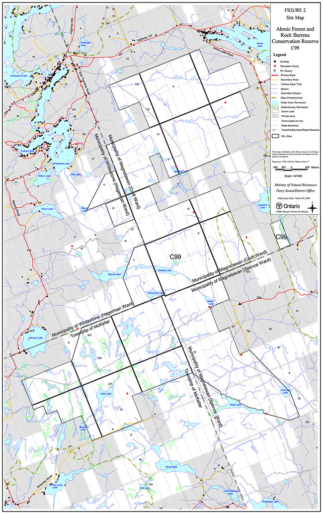
Ahmic Forest and Rock Barrens Conservation Reserve is a 6,081 hectare area of Crown land. It extends to 2 kilometres southeast of the hamlet of Dunchurch and 5 kilometres east of the hamlet of McKellar in the Territorial District of Parry Sound. The eastern half of the site is within the Municipality of the Township of Magnetawan (Croft and Spence wards), with lesser amounts within the Township of McKellar and the Municipality of Whitestone (Croft and Hagerman wards).
This large area contains approximately 55 different habitats that provide ecological representation in Site District 5E -8. This will ensure the protection of many landscape features in a single area. The rugged landscape includes sugar maple forests growing on hills of fine glacial deposits called tills, rock barrens with balsam fir and white cedar forests, and white pine, ash, red oak and maple forests growing on bare bedrock uplands. Wetlands also occur on a variety of landforms. This diversity of natural features adds to the significance of this site. Portions of this natural heritage area are within the Oranmore deer yard.
Ahmic Forest and Rock Barrens Conservation Reserve is one of 378 new protected areas approved through Ontario’s Living Legacy Land Use Strategy, aimed, in part, at completing Ontario’s system of parks and protected areas.
During the “Lands for Life” planning process, the public was widely consulted and provided valuable input into what became Ontario’s Living Legacy Land Use Strategy. During consultation related to the formal Public Lands Act (Ontario Regulation 805/94) regulation of the boundaries of this conservation reserve (in 1999 and 2000) a number of minor boundary changes were made to resolve concerns over access to private lands, and to ensure the boundaries reflected areas requiring protection. Comments received during the 2000 consultation were generally supportive of the protection of this area. Stakeholders who provided comment during the earlier consultation for this site were subsequently consulted regarding the draft Statement of Conservation Interest and their comments were considered in the finalization of this document.
This Statement of Conservation Interest provides guidance for the management of the conservation reserve and provides the basis for the ongoing monitoring of activities. More detailed direction is not anticipated at this time. Should more complex resource management or conservation issues arise or significant facility development be considered, then a detailed Resource Management Plan will be prepared with full public consultation.
Ahmic Forest and Rock Barrens Conservation Reserve is managed under the direction of the District Manager and the Parry Sound Area Supervisor of the Ministry of Natural Resources, Parry Sound District.
Approved by:
R. Griffiths
District Manager
Parry Sound District
Approved by:
Ron Running
Regional Director
Southcentral Region
1.0 Introduction
Ontario’s Living Legacy, the result of an extensive planning process that began in early 1997, culminated in the approval in July 1999 of a Land Use Strategy that identifies the intended strategic direction for Crown land, including the completion of Ontario’s system of parks and protected areas. This process, which included extensive public consultation, resulted in the recommendation for regulation of 378 new protected areas, including Ahmic Forest and Rock Barrens Conservation Reserve (C99).
Ahmic Forest and Rock Barrens Conservation Reserve is located in the Territorial District of Parry Sound. It extends to 2 kilometres southeast of the hamlet of Dunchurch and 5 kilometres east of the hamlet of McKellar in the Territorial District of Parry Sound. The eastern half of the site is within the Municipality of the Township of Magnetawan (Croft and Spence wards), with lesser amounts within the Township of McKellar and the Municipality of Whitestone (Croft and Hagerman wards).
Ahmic Forest and Rock Barrens Conservation Reserve encompasses a large area of remote forest and rock barrens habitat. Owing to its relatively large size of 6,081 hectares, the conservation reserve contains a diversity of botanical and wildlife habitats.
The conservation reserve is located southeast of Ahmic Lake, which is part of the Magnetawan River system. The northern portion of the reserve forms part of the Magnetawan River’s catchment area, while the southern portion drains into the Manitouwabing River and thence into the Seguin River. These three rivers, along with the French and Pickerel Rivers to the north, are historically significant.
Conservation reserves are established under the authority of the Public Lands Act, Ontario Regulation 805/94. Ahmic Forest and Rock Barrens Conservation Reserve was established by Ontario Regulation 86/01, an amendment of the Public Lands Act, on April 6, 2001.
A Statement of Conservation Interest (SCI) is prepared under the authority of Procedural Guideline A – Resource Management Planning (PL. Procedure 3.03.05). The purpose of this SCI is to identify and describe the values of Ahmic Forest and Rock Barrens Conservation Reserve. The SCI also outlines the activities that currently occur within the conservation reserve and provides guidelines for the management of current and future activities in the context of protecting the natural, recreational and cultural values.
1.1 Background information:
| Name | Ahmic Forest & Rock Barrens Conservation Reserve (C99) |
|---|---|
| Site Region/District | Georgian Bay 5E -8 |
| OMNR Administrative Region/District/Area |
Southcentral Region/Parry Sound District/ Parry Sound Area |
| Total Area (ha.) | 6,081 hectares |
| Regulation Date | April 6, 200 1 (O. Reg. 86/01) |
| First Nations | Robinson-Huron Treaty |
| OBM map sheets Topographic Map |
10 17 5850 50400, 10 17 5900 50500, 10 17 5950 50400, 10 17 5900 50450, 10 17 5950 50450, 10 17 5900 50500, 10 17 5950 50500, 10 17 5900 50550, 10 17 5950 50550 Magnetawan 31E/12 |
| UTM co-ordinates | 17T 594600 5048500 (Centroid) |
1.2 Representation:
Earth science representation:
Bedrock - Metagranodiorite to meta-quartz diorite are typical representations of the metaplutonic component of the Parry Sound Domain, Parry Sound Terrane, in the northwestern part of the Central Gneiss Belt of the Proterozoic Grenville Province.
Surficial - Sandy till of glaciolacustrine and sandy and gravelly till of glacicofluvial ice-contact origins and glaciolacustrine deposits are typical components of the Late Wisconsinan Stage of the Quaternary Era in southwestern Ontario.
Life science representation:
A large area of remote forest and rock barrens containing a diversity of botanical and wildlife habitats, including:
- rock barrens supporting a sparse forest of stunted red oak (Quercus rubra), white pine (Pinus strobus), red maple (Acer rubrum) and occasionally, large-toothed aspen (Populus grandidentata);
- deeper soil pockets supporting the same tree species, which, however, are much less stunted, with a forest understory which includes a greater diversity of herbaceous plants, such as wild sarsaparilla (Aralia nudicaulis), starflower (Trientalis borealis), long-awned wood grass (Brachyelytrum erectum ) and intermediate woodfern (Dryopteris intermedia);
- valley forests containing large, mature, mixed stands of sugar maple (Acer saccharum ), and yellow birch (Betula alleghaniensis) interspersed with eastern hemlock (Tsuga canadensis), and eastern white cedar (Thuja occidentalis);
- pockets of poorly drained silty clays, inherently moist and drought resistant, supporting either deciduous forests, (sugar maple, red maple, basswood (Tilia americana) yellow birch, and eastern hemlock) or conifers such as eastern hemlock or white spruce (Picea glauca). The associated forest supports herbaceous species such as large flowered trillium (Trillium grandiflorum), red trillium (Trillium erectum ), interrupted fern (Osmunda claytoniana), New York fern (Thelypteris noveboracensis), false Solomon’s seal (Maianthemum racemosum ) and bladder sedge (Carex intumescens);
- a variety of wetland types including minerotrophic graminoid/sedge marshes, a fen-type wetland (with yellow-eyed grass (Xyris difformis), a provincially rare post-glacial disjunct species usually associated with Atlantic coastal plains flora (ACPF)), and a lacustrine marsh, part of a much larger lacustrine marsh complex found in Crawford Lake and Neighick Lake.
Cultural resources representation:
Neither detailed cultural research nor invent ory has been carried out for this conservation reserve. However, there is some site evidence of early logging activity, probably ending by the 1940s. Evidence of pioneer homesteading (abandoned trails, old fields and clearings, and remnants of buildings) is also found within the conservation reserve. The conservation reserve is a part of two separate river systems which have historical significance: the northerly portion drains toward the Magnetawan River, and the southerly portion drains toward the Manitouwabing River and thence into the Seguin River. Recent regional evaluation (OMNR 2003) shows that this conservation reserve contains areas that have a high potential for cultural heritage sites.
Recreational opportunities:
A recreational inventory report was prepared for this site based on existing knowledge and data sources of MNR staff, and reflecting field observations made during the preparation of the life science report (Brown, 2002). The area is recognized as providing many recreation opportunities. It accommodates big and small game hunting, snowmobiling, and some sport fishing. All-terrain vehicle use is becoming increasingly common. Seven recreation camps, authorized by MNR through the Public Lands Act, Ontario Regulation 805/94, are located within the conservation reserve and three others are located close to the site boundaries.
1.3 Survey work:
| Survey Level | Earth Science |
Life Science | Cultural | Recreational | Other |
|---|---|---|---|---|---|
| Reconnaissance | Duba & Frey, 2001 | Blythe & Assoc., 2002 | OMNR, 2003 | Brown, 2002; (Inventory Report) | None |
| Detailed Requirement |
None None |
None Monitor the status/presence of significant species and associations. |
None Research to be encouraged. |
None Monitor use impacts |
None None |
2.0 Values to be protected
The conservation reserve is located entirely within Hills’ (1959) ecological Site District 5E -8. Values include earth science, life science and recreational/aesthetic values, with an emphasis on the life sciences.
2.1 Earth science:
Bedrock:
(Earth science information, unless otherwise noted, is taken from Duba and Frey, 2001)
Ahmic Forest and Rock Barrens Conservation Reserve is an area of extensive bedrock barrens interspersed with numerous lakes, interconnecting drainages and wetlands. The dominant rock types exposed are metagranodiorite or meta-quartz diorite of the Parry Sound Domain, Parry Sound Terrane in the Proterozoic Central Gneiss Belt of the Grenville Province. These are typical representations of the metaplutonic component of the Parry Sound Domain (Parry Sound Terrane). However, numerous other compositional and structural elements of the Parry Sound Domain probably are absent in this conservation reserve.
The Parry Sound Terrane is one of four lithotectonic terranes of the Central Gneiss Belt. Within the Parry Sound Terrane, the Parry Sound Domain is one of three structural domains. This geological environment is part of the modern organization of the complex products of the mid-Proterozoic Grenville orogenic events (Easton, 1992a & b). As such, its representation in Ahmic Forest and Rock Barrens Conservation Reserve contributes to the conservation of the Grenville continental accretion theme outlined by Davidson (1981).
The Grenville Province is the product of thrusting and imbrication of the earth’s crust to the northwest as it collided with a continental land mass to the southeast. The Grenville Orogeny, circa 1140 to 1070 million years ago, culminated more than 500 million years of crustal evolution. The eroded roots of the products of these events are displayed in the complexly metamorphosed and deformed rocks of the region (Easton, 1992b).
Within the Ontario Provincial Park system, the bedrock geological features observed in Ahmic Forest and Rock Barrens Conservation Reserve have regional significance.
Surficial:
Glacial striae on exposed bedrock provide evidence of the Late Wisconsinan glaciation. The area was flooded in the expansion of glacial Lake Algonquin during deglaciation, after about 11,500 years before present (BP) (Eschman and Karrow, 1985). With the retreat of the ice-front north and northeasterly, and the opening of successively lower outlets in the North Bay area, about 10,200 years BP, the glacial lake drained rapidly to the low level of glacial Lake Hough and the region was exposed for the first time since the onset of deglaciation.
More than 75% of the conservation reserve is underlain by thin (<1 m) discontinuous drift cover over bedrock, and bedrock drift complex comprising sandy till of glaciolacustrine and sand and gravel of glacicofluvial ice- contact origins. Glaciolacustrine deposits of clay, silt and sand with minor gravel occur as subordinate small patches throughout the area. (Kor and Delorme, 1989)
Organic deposits of drainages and wetlands underlie the low relief terrain between uplands.
The surficial geological features are locally significant. The topography of this site features rugged steep hills of granitic bedrock encompassing two similar landform types, “shallow till and rock ridges” and “rock ridges and shallow till”. (Chapman and Putnam 1984) The surficial topography has also been heavily influenced by glacial scouring, followed by erosion and reworking by the receding waters of post-glacial Lake Algonquin. The tills, sandy till of glaciolacustrine and sandy and gravelly till of glacicofluvial ice-contact origins, and glaciolacustrine deposits are typical components of the Late Wisconsinan Stage of the Quaternary Era in southwestern Ontario.
2.2 Life science:
(Life science information, unless otherwise noted, is taken from Blythe & Associates, 2002)
In late May 1997, the Ministry of Natural Resources (Natural Heritage Information Centre and Natural Heritage Section) carried out a natural heritage “gap analysis” project for Site District 5E -7 and 5E -8, in conjunction with Ontario Living Legacy’s Land Use Planning. The purpose of the gap analysis was to identify different vegetation and landform combinations that were not included in protected areas at that time. Geographic Information Systems technology was used and applied to the following criteria: 1) representation of landform -vegetation patterns; 2) diversity; 3) condition; 4) ecological considerations; and 5) special features (Crins and Kor 1998). Much of the area of Ahmic Forest and Rock Barrens Conservation reserve was identified through this gap analysis.
Representation:
Ahmic Forest and Rock Barrens Conservation Reserve encompasses a large area of remote forest and rock barrens habitat. Owing to its relatively large size the reserve contains a diversity of botanical and wildlife habitats.
The surficial topography has also been heavily influenced by glacial scouring, followed by erosion and reworking by the receding waters of post-glacial Lake Algonquin. These factors, in combination with logging activities of the late 19th and early 20th centuries and the influence of one or more large post-logging forest fires, have created the present day rock barrens environment that exists throughout much of the conservation reserve.
These rock barrens support a sparse forest of stunted red oak, white pine, red maple and occasionally, large- toothed aspen. The wide spacing between the trees and the predominant ground cover of poverty oat grass (Danthonia spicata) and common hairgrass (Deschampsia flexuosa) gives this landscape a savannah-like aspect. The actual hilltops are bare rock knobs that only support shrubs and grasses. Ubiquitous to the landscape are large desiccated and charred white pine stumps, remnants of a former white pine forest which was removed during the square timber logging era of the late 19th and early 20th centuries. Indeed, the majority of the conservation reserve shows evidence of a past fire -dependent ecosystem and evolution towards a similar fire -dependent regime.
The exceptions to this general trend are the frequently occurring shallow depressions in the bedrock. The shallow pools formed in these depressions have resulted in the formation of micro-wetlands — usually less than 100 m² — which dot the landscape. These wetlands produce a thin layer of organic soils over bedrock. In addition, there are other low lying areas, where the eroded soils from the original pre-logging soil mantle have accumulated and provide a relatively deep layer of sandy soil. The deeper soil pockets support the same tree species that grow on the rock barrens, however, the resultant red oak, white pine and red maple forest are much less stunted. In addition, the forest understory associated with these soil pockets includes a greater diversity of herbaceous plants, such as wild sarsaparilla, starflower, long-awned wood grass and intermediate woodfern.
In direct contrast with the predominant upland rock barren landscape, are the deeper valleys that lie between the rugged rock hills. These valley forests contain large, mature, mixed stands of sugar maple, and yellow birch interspersed with eastern hemlock, and eastern white cedar. In a few of the deeper more inaccessible valleys, it appears the forest may have been logged lightly, or not at all, as evidenced by the many large yellow birch, hemlock and cedar trees. These remote areas also lack obvious evidence of the cut stumps frequently observed in other parts of the conservation reserve.
Similarly, pockets of poorly drained silty clays, attributable to post-glacial lacustrine deposition, are located throughout the conservation reserve. Owing to the nature of their deposition, these soils occur in scattered areas and are generally found at lower elevations within the rocky terrain. The soils that have developed from silty clay parent materials are part of the Magnetawan Soil Series. They are noted for their relative fertility in relation to the dominant MonteagleGravelly Sand Complex (Hoffman et al. 1962). These fine textured soils are inherently moist and drought resistant and usually support either deciduous forests, or conifers such as eastern hemlock or white spruce. This is best exemplified in the northeast quadrant, where the hardwood forest is primarily mature and even-aged with sporadic occurrences of very large specimens of sugar maple, red maple, basswood, yellow birch, and eastern hemlock.
The forest understory in the northeast quadrant is best typified as medium rich and moist in character. It supports herbaceous species such as large flowered trillium, red trillium, interrupted fern, New York fern, false Solomon’s seal and bladder sedge. The even-aged characteristics of the forest stands, along with the size class of average trees, indicates the area was clear cut between 60 and 80 years ago. The silt loams grade out to gravelly sand on the higher points of land. In these locations, species such as red oak, white ash (Fraxinus americana) and hop hornbeam (Ostrya virginiana) predominate. This is also one of the few areas within the conservation reserve where few remnant white pine stumps were observed and where evidence of previous forest fires is not apparent.
Many of the low-lying areas between the rock hills are occupied by a variety of wetland types. Two of the most common wetland types are graminoid/sedge meadows, and flooded rock valleys filled with aquatic vegetation such as, fragrant water lily (Nymphaea odorata), bullhead lily (Nuphar variegatum), and watershield (Brasenia schreberi). Both of these wetland types owe their current charac teristics to either a presence, or absence, of active beaver colonies. The majority of wetlands in this particular area, and within the conservation reserve as a whole, are minerotrophic graminoid/sedge marshes. They are dependent on the activity of beaver for their existence. One small fen-type wetland was discovered at the end of Blackberry Lake. It did contain some species of plants typically associated with fen and bog environments, specifically pitcher plant (Sarracenia purpurea), sundew (Drosera spp.), beakrush (Rhynchospora spp.) and tawny cotton grass (Eriophorum virginicum). Of particular note in this portion of the conservation reserve was the discovery of yellow-eyed grass, a post-glacial disjunct species usually associated with Atlantic coastal plains flora (ACPF)). This species is considered provincially rare. In addition, some of the more common ACPF) species, such as twig rush (Cladium mariscoides), pickerel weed (Pontederia cordata) and floating heart (Nymphoides cordata) were observed throughout the conservation reserve.
A small portion of the conservation reserve lies east of the main site and directly south of Crawford Lake — part of the Ahmic Lake/Magnetawan River system. It is comprised of a one hundred acre lot through which the Neighick River flows. This disjunct portion of the conservation reserve is primarily a lacustrine marsh, which is part of a much larger lacustrine marsh complex found in Crawford Lake and Neighick Lake. A small portion of the lot, located on its western boundary, is an immature mixed wood stand. This wetland is dominated by aquatic plant species such as water horsetail (Equisetum fluviatile), floating burreed (Sparganium fluctuans), pickerel weed, floating heart, water shield, fragrant water lily, purple bladderwort (Utriculata purpurea ) and an assortment of pondweeds (Potamogeton spp.). This extensive area of aquatic vegetation is rich in species diversity and is critical habitat for both fish and assorted herpetofaunal species. It also provides valuable staging and feeding habitat for migratory waterfowl.
Condition:
While there is ample evidence of early logging throughout the site there have been no recent resource extraction activities in the conservation reserve and such activities are no longer permitted in the conservation reserve. Evidence from cut stumps would indicate that the most recent logging was approximately 60 years ago and confined to those portions of the hardwood forest located in the northeast quadrant of the conservation reserve. In this same area, there is evidence of an extensive axe girdling stand improvement operation conducted by the OMNR/Lands and Forests in the 1970’s.
In most parts of the site, where there are hardwood stands, traces of old logging roads are often encountered. Parts of these trails and roads now form the travel corridors of present day snowmobile and all -terrain vehicle trails. Some portions of the site reveal the passage of wildfires in forest stands as recently as 50 years ago. Evidence of these fires remains in cha rred stumps observed within intolerant hardwood stands of this approximate age.
An abandoned gravel pit, apparently used for local road construction, is located in the southeast quadrant of the conservation reserve. The pit is part of a now abandoned agricultural field and was at one time patented land that has since reverted to the Crown. A rough road leads north and westward from this field to the southwest shore of Nelson Lake to an OMNR land use permit (recreation camp).
A second recreation camp is also located in the southeast quadrant of the conservation reserve The camp consists of two buildings, one of which, an old squared log structure, may be part of the original pioneer settler’s dwelling. A trail leads away to the southwest and apparently ends at Ryder Creek, which flows into Ryder Lake. A more recently constructed metal clad recreation camp is located in the northeast quadrant of the site near a small beaver pond wetland complex. Access to this camp appears to be from the east via an unopened concession road allowance. Similarly, there are four other recreation camps scattered throughout the conservation reserve with additional three recreation camps close to its boundaries.
Access to the southern part of the conservation reserve is relatively easy with a two -wheel drive vehicle, via either the Nelson Lake Road in the southeast, or in the southwest quadrant, via Highway 124, to Centre Road, to Brownley Road and onto an unnamed cottage road north of Mary Jane Lake. A more difficult access route to the site is also available at the approximate midpoint of the western boundary. This access is from Highway 124, to Balsam Road, to the intersection of Carlton Road, approximately 4.23 kilometres west of the conservation reserve’s boundary. The Carlton Road access is extremely difficult; the road is very narrow and barely passable using a two-wheel drive vehicle. Eventually, the Carlton Road and the road/trail to the conservation reserve become impassable to all vehicles except four -wheel drive trucks and all -terrain vehicles. The recently constructed logging road is very rough and is now heavily overgrown with vegetation. There is no indication that this road, beyond the fork, receives any significant traffic.
In the northeast quadrant, the Ahmic Lake Road passes within a 100 -acre lot width of the conservation reserve’s boundary. Access by foot is possible, following the unopened road allowance west, from the southwest corner of Lot 20, Concession 7 in Croft Township.
The conservation reserve is also traversed by three snowmobile trails. The Ontario Federation of Snowmobile Clubs (OFSC) Trans Ontario Provincial Connector Trail, C101, more -or-less bisects the site on a north-south axis, while two local snowmobile trails, # 802 and # 803, intersect the provincial trail from the west and south respectively. Several smaller, unofficial, unmapped trails were also noted. The sections of trail observed by the survey team in 2002 appear to be relatively free from environmental degradation.
Currently, most all-terrain vehicle trails are associated with hunt camps and there does not appear to be any solely recreational all -terrain vehicle activity within the conservation reserve. If, however, the popularity of all- terrain vehicle use grows to the magnitude of recreational snowmobiling in the area, the negative impact on the reserve’s landscape and its wildlife habitats will increase. The recreational use of all-terrain vehicles, especially in the spring and summer months when vegetation is actively growing, can predispose an area to increased soil erosion. This is particularly true in areas of fine textured clay/silt soils and organic soils such as those associated with wetlands. As trails become increasingly rutted and eroded, broad, shallow mud holes form in depressions and at the bottom of slopes. The tendency of all-terrain vehicle operators to drive around these wet and muddy sections widens the trails and ultimately expands the areas of damage.
Diversity:
The general lack of soil, the exposed bedrock hills, and the dominance of the red oak/white pine savannah- like habitat, make this conservation reserve a good example of a fire -dependent ecosystem. The terrain itself is relatively diverse. It features rugged rock barren hills and plains, fertile valley lands, sporadic silt/clay loam pockets, wetlands, watercourses and lakes. From a visual landscape perspective, the site offers scenic vistas varying from steep 30 metre high cliff faces to flat rock barren plateaux.
Owing to the size of the conservation reserve, it provides a diversity of floral and faunal habitats ranging from the relatively nutrient poor areas of the rock barrens to the fertile graminoid/sedge wetlands and the silt loam pockets that support mature bottomland forests. In general, the areas of the conservation reserve richest in species are those valley bottomlands and associated wetlands. Approximately 215 botanical species were recorded in the conservation reserve during a five-day late summer botanical survey in August 2002. Although the vast majority of these species were relatively common, one, yellow-eyed grass was found to be provincially significant.
The forest is diverse. There are extensive areas of stunted red oak/white pine savannah-like barrens which have been subjected to one or more wildfire events, isolated ridges of mature white pine and hemlock, large mature, uneven-aged yellow birch/hemlock in deep valley forests, even-aged tolerant hardwood stands and very small pockets of even -aged intolerant poplar and white birch. The red oak/white pine forest situated on the rock barrens is currently in an early stage of succession. However, it appears to be advancing toward its former state of a fire-dependant white pine dominated ecosystem. Owing to the severity of the post-logging fires of the early 20th century, and the consequent loss of the thin layer of topsoil from the bedrock surface, this process may take several centuries. The remnant white pine stumps appear to play a key role in the slow re-vegetation process of the rock barren landscape. The decaying stumps and, much less frequently, tree trunks act as small islands of organic soils and reservoirs of moisture, relative to the rock barren itself. Individual stumps and the area immediately around them provide micro -climatic conditions that allow small trees and shrubs to grow. There is also some indication these stumps, and the soils associated with their spreading root architecture, may have protected and retained some of the former forest flora seed bank following fire events. In particular, small shrubs such as wintergreen (Gaultheria procumbens) and bunchberry (Cornus canadensis) are often found on the barrens growing in close proximity to the old pine stumps – these plants are common associates in the shaded understories of existing white pine stands.
From a wildlife perspective, the site is significant for a number of reasons. Its relative remoteness, size, and lack of anthropogenic disturbance throughout the conservation reserve provide ideal conditions for numerous species. In particular, the mixture of rock barrens, tolerant hardwood forests, and assorted wetlands seems to provide a large contiguous area of suitable habitat for several herpetofaunal species including, the threatened eastern hognose snake (Heterodon platirhinos ), although, no specimens of this snake were observed during the late summer survey of 2002. Similarly, the reserve appears to have some areas of habitat suitable to the Massasauga rattlesnake (Sistrurus catenatus catenatus), however, no rattlesnakes were observed and the inland climate, relative to their normal habitat in the Georgian Bay coastal barrens, may be too severe to allow their survival.
In most valleys and on slopes, where species such as hobblebush (Viburnum lantanoides) and red maple were observed, there is abundant evidence of winter moose browsing. Similarly, there was ample evidence that the area provides good summer range for white-tailed deer. Although, the conservation reserve does not contain any significant stands of eastern hemlock, portions of the Oranmore deer yard are located within the reserve boundary in the east, and the Mary Jane Lake deer yard is close to the southwest quadrant. The primary importance of the site to these deer wintering areas is the production of red oak acorn mast crops in the fall.
The rock barrens are also highly attractive to black bear as feeding sites during the late summer and autumn. The main food source is the acorn mast crop produced on the red oak/white pine savannah-like barrens. To a lesser extent, the rock barrens may, occasionally, produce crops of blueberries (Vaccinium myrtilloides and V. angustifolium). Black bear also tend to use the rock barrens as a source of invertebrate foods.
Open habitats of this type, with an abundance of water, scattered shrubs and stunted trees, are favoured as nesting habitats by a large number of avian species. Of particular note, the prairie warbler, a rare species in Ontario, prefers habitat of this type and is known to nest in the coastal barrens lands to the west of the conservation reserve (M.D. Cadman et al., 1987).
Ecological considerations:
By virtue of its large size, relatively undisturbed condition, and remote characteristics, this conservation reserve is unique. This site is just over 5 kilometres from Dutcher Lake Forest Conservation Reserve, C87, which has a similar rock barren environment. Together with the intervening lands, they provide diverse, relatively undisturbed habitat for moose, white-tailed deer, timber wolf (Canis lupus), coyote (Canis latrans) and black bear. All of these species commonly inhabit this remote part of the Parry Sound District.
The dominance of the red oak/white pine savannah-like forest and its periodic abundance of acorn mast crops provide an important source of food for white-tailed deer, black bear and 28 other species of wildlife that eat acorns in central Ontario (Naylor, 2000). The presence of this relatively uncommon forest type, and the mast crop it produces, is critical for the maintenance of wildlife populations well beyond the boundaries of the conservation reserve, as birds and large mammals will travel overland to feed on acorns in late summer and autumn.
In addition, the lacustrine marsh, located in the disjunct portion of the conservation reserve, provides a relatively uncommon and rich wetland habitat relative to those usually encountered on the Precambrian Shield. These marshes are an important source of habitat and food for a variety of fish, herpetofaunal and waterfowl
Special features:
With the exception of the occurrence of some common, and one rare species (Atlantic Coastal Plain flora) — yellow-eyed grass — the site does not appear to have any special botanical features. From a geological perspective, the rock barrens afford an excellent opportunity for understanding the underlying geological structure of the granite bedrock in the area.
2.3 Cultural values:
While no specific cultural studies or inventories have been undertaken within the conservation reserve, and no major cultural resource values have been evaluated or identified to date, there is physical evidence of early logging and homesteading throughout this conservation reserve, and other evidences of early 20th century use of area. (Blythe & Associates, 2002)
Recent regional evaluation (OMNR, 2003) shows that this conservation reserve contains areas that have a high potential for cultural heritage sites.
2.4 Recreational/aesthetic values:
Hunting and fishing appear to be the primary recreational activities that have traditionally occurred within the reserve’s boundaries. As previously noted, there are seven recreation camps (Land Use Permits) within the conservation reserve and an additional three are located on adjacent Crown land.
The conservation reserve supports the usual populations of large and small game. Most hunting activity within the site is focused on white-tailed deer (Odocoileus virginianus),), moose (Alces alces), and to a much lesser extent, black bear (Ursus americanus). The reserve is divided between three OMNR Bear Management Areas: PS-49-05, PS -49-06 and PS-49 -08.
The disjunct portion of the reserve, that area encompassing the Crawford Lake lacustrine marsh and the Neighick River, is a popular spot for waterfowl hunters. Approximately six duck blinds from the 2001 hunting season were noted in this small area. This portion of the conservation reserve is easily accessible by boat or canoe from the Ahmic Lake Road to the northeast.
Sport fishing also occurs as a secondary recreational activity, with game fish species recorded in at least three of the waterbodies within the site’s boundaries. (Shanty Lake, smallmouth bass (Micropterus dolomieui); Nelson Lake, smallmouth bass, largemouth bass (Micropterus salmoides), and yellow perch (Percaflavescens ); Ryder Lake, northern pike (Esox lucius) and yellow perch) In addition, the 100 -acre disjunct section of the reserve that encompasses a portion of the Crawford Lake lacustrine marsh and the Neighick River is excellent fish habitat and is directly linked to the Magnetawan River.
Snowmobiling is the only other significant recreational activity, which takes place within the conservation reserve as an organized sport. As previously noted, there are one major and two minor snowmobile trails that traverse the site. The de gree of use by hikers, birdwatchers, canoeist, mountain bikers, skiers, or snowshoe enthusiasts is, for the most part, unknown since these activities have a relatively low impact on the landscape, and tend not to be represented by organized user -group associations.
All-terrain vehicle use of the site has increased in recent years, with access gained by way of the snowmobile trails and other old trails. A number of all-terrain vehicle trails have developed, some of which may be in conjunction with a number of recreation camps within and near the conservation reserve.
3.0 Management guidelines
3.1 Land tenure:
Background:
Ahmic Forest and Rock Barrens Conservation Reserve comprises 6081 hectares of Crown land. There are adjacent Crown lands on the west and south boundaries, with other scattered Crown lots to the north and east, but most of the lands adjacent to the conservation reserve are in private ownership. There are no private lands included within conservation reserve boundaries. Most road allowances throughout and adjacent to the conservation reserve remain under the authority of the municipalities wherein they lie, and are not included as part of the conservation reserve. The exception is in Spence Township where the road allowances within the site were closed in December 1999 and those lands are now within the conservation reserve.
The conservation reserve is divided between three OMNR Bear Management Areas: PS-49 -005, PS -4 9-006 and PS-49 -008. (The McKellar portion of the conservation reserve is not within a Bear Management Area.) There are also three OMNR registered traplines that have portions of their harvest areas within the conservation reserve. The conservation reserve lies within parts of four commercial Bait Fish Blocks which are currently assigned.
There are seven recreation camps within the conservation reserve and an additional three recreation camps are located on adjacent Crown land, all authorized by Land Use Permits under the authority of the Public Lands Act, Ontario Regulation 805/94. There is also a trappers cabin.
The site is traversed by three snowmobile trails authorized by land use permit. The Ontario Federation of Snowmobile Clubs (OFSC) Trans Ontario Provincial Connector Trail, C101, more-or -less bisects the reserve on a north-south axis, while two local snowmobile trails, # 802 and # 803, intersect the provincial trail from the west and south respectively.
There are no authorized commercial boat caches within the conservation reserve. Some boats and canoes are located within the conservation reserve, possibly in connection with nearby recreation camps.
Guideline:
The sale of Crown lands within the conservation reserve is generally not permitted. Exceptions will only be considered under unusual circumstances, such as where a pre-existing adjacent privately owned parcel has inadequate area for the installation of a septic system.
There are no plans by the MNR to acquire private lands to add to the conservation reserve.
The commercial bear hunting service associated with the current Bear Management Areas is allowed to continue. Fur harvest is permitted to continue in the registered trapline areas. The Bait Fish Blocks are currently assigned and are permitted to continue.
Private boat caches are not allowed to occupy Crown land without authorization.
The existing recreation camps within the conservation reserve are permitted to continue. They may be eligible for “enhanced” tenure, but are not eligible for purchase of land. (See Appendix 4)
New recreation camps are not permitted.
3.2 Development:
Background:
There are no Crown owned buildings or other facilities within the conservation reserve.
Three authorized snowmobile trails pass through the conservation reserve. The Ontario Federation of Snowmobile Clubs (OFSC) Trans Ontario Provincial Connector Trail, C101, more-or -less bisects the reserve on a north-south axis, while two local snowmobile trails, # 802 and # 803, intersect the provincial trail from the west and south respectively. Unauthorized trails have also been noted.
Currently, most all-terrain vehicle use is associated with recreation camps (apparently used mostly during the late autumn hunting seasons). There is a network of trails that covers most of the conservation reserve (Brown, 2002). While there does not appear to be any solely recreational all-terrain vehicle activity within the conservation reserve, this use is expected to increase.
Guideline:
New roads for resource extraction and/or private use will not be permitted, nor will additions to existing roads, or up grading of existing roads be permitted. The only exception would be that new roads necessary to enable mineral exploration and development of mining claims and leases outside of the conservation reserve are permitted, with appropriate consideration for the protection of conservation reserve values.
No mineral exploration is permitted within this conservation reserve. This policy decision is based on a commitment made by the Ministry of Natural Resources and the Ministry of Northern Development and Mines in March 2002. This policy direction replaces that identified in the 1999 Ontario’s Living Legacy Land Use Strategy (OMNR, 1999), which stated that controlled mineral exploration would be permitted in new conservation reserves which were identified as having provincially significant mineral potential.
In general, existing authorized recreational trails may be permitted to continue in conservation reserves as long as they do not impair the natural features and values for which the ar ea is identified and as long as there are no significant environmental impacts. Accordingly, the three authorized snowmobile trails continue to be authorized, but their use will be monitored to ensure that conservation reserve values are not being adversely impacted. Additional recreational trails are not encouraged, but may be considered on a case by case basis. Public consultation will be an important part of the consideration of any new trails, and they would also be required to comply with Procedural Guideline B – Land Uses – Test of Compatibility (Appendix 1).
While there is no intent at present to provide or permit any new development in this conservation reserve that would require lighting, should this be considered at some point in the future the MNR will not allow unnecessary, undirected light pollution. This commitment recognizes the wilderness values provided by a pristine night sky.
3.3 Recreational activities:
Background:
Snowmobiling is the major significant recreational activity which takes place within the conservation reserve as an organized sport. As previously noted, there are one major and two minor authorized snowmobile trails that traverse the site, as well as some connecting trails.
Other existing recreational uses include hunting and sport fishing; there appears to be potential for increasing all-terrain vehicle use.
As noted in Section 2.4, hunting for white-tailed deer, moose and, to a much lesser extent, black bear is an important recreational activity within the conservation reserve. The disjunct portion of the conservation reserve, that area encompassing the Crawford Lake lacustrine marsh and the Neighick River, is popular for waterfowl hunting.
Sport fishing occurs in at least three of the waterbodies within the conservation reserve’s boundaries, and in the disjunct portion to the east.
All-terrain vehicle trails, mostly associated with the recreation camps, crisscross the conservation reserve. Although their use is primarily seasonal, associated with the fall hunting season, there is potential for the creation of unauthorized trails by all-terrain vehicles.
There is little evidence of the use of the conservation reserve by hikers, birdwatchers, canoeists, mountain bikers, skiers, or snowshoers.
Guideline:
Hunting and sport fishing are permitted to continue within the conservation reserve.
Recreational use such as hiking, wildlife viewing, snowshoeing, and cross -country skiing, while currently very limited in extent and therefore not managed, will be allowed to occur in the conservation reserve.
The existing authorized snowmobile trails will continue to be authorized, but their use will be monitored to ensure that the conservation reserve values are not being adversely impacted.
New recreational trails or changes to the existing routes are not permitted without prior MNR authorization. New trails are not encouraged, but may be considered on a case by case basis provided they meet the Procedural Guideline B - Land Uses - Test of Compatibility (Appendix 1) and the MNR’s Environmental Assessment Act requirements.
The use of existing unauthorized recreational trails, and any increase in use of all-terrain vehicles, will be monitored to ensure that conservation reserve values are not being adversely impacted. Depending on the results of monitoring, some of the unauthorized trails may need to be redirected from sensitive areas or eliminated completely. Otherwise, there is no intent to mark or upgrade these trails. Off-trail use of snowmobiles and all -terrain vehicles is permitted for the direct retrieval of game only.
New recreational activities will be considered on a case by case basis provided they are consistent with maintaining the values of the conservation reserve and comply with Procedural Guideline B - Land Uses - Test of Compatibility (Appendix 1). Emphasis will be placed on activities that have a low impact on the environment of the conservation reserve.
3.4 Commercial activities:
Background:
There has been no recent commercial forest harvesting or mining activity within the conservation reserve.
Commercial fur harvesting is authorized through registered traplines. The guiding of non -resident bear hunters is authorized through Bear Management Areas, and bait fish harvesting is authorized through Bait Fish Block licences within the conservation reserve.
Guideline:
Fur harvesting, bear hunting services and bait fish harvesting operations are allowed to continue within the conservation reserve.
Mineral exploration is not allowed in this conservation reserve, as discussed in Section 3.2.
Conservation reserve regulations do not permit mining, commercial forest harvesting, hydroelectric power development, the extraction of aggregate and peat or other industrial uses (Public Lands Act, Ontario Regulation 805/94). Other new commercial activities must meet the requirements of Procedural Guideline B - (see Appendix 1).
3.5 Aboriginal interests:
Background:
This site is located within the area of the Robinson – Huron Treaty of 1850, and as such the general area of this conservation reserve is known to be of interest to various First Nations.
Guideline:
The regulation and management of this conservation reserve will not impede the exercise of existing aboriginal or treaty rights. These rights include hunting, fishing, fur harvesting, gathering of plants for a variety of purposes, and the use of ceremonial sites. It is recognized that the manner in which these rights are carried out is not limited to the manner in which they were carried out in the past, but has evolved over time with changes in technology.
While there are no existing First Nation land claims that extend to this site, it is recognized that at some point in the future there is a possibility of a land claim in this area. If such a land claim is determined to be valid, the Conservation Reserve designation is not irreversible and does not preclude consideration of these lands in the settlement of a claim.
3.6 Natural resource stewardship:
Except for historic logging, and an extensive axe girdling stand improvement operation conducted by the OMNR/Lands and Forests in the1960’s (to improve stand spacing and remove undesirable tree species, or poorly formed commercial species) vegetation management for specific purposes is not known to have occurred in the past. Wildlife and fisheries management, particularly sport fishing, hunting and fur harvesting, have been occurring according to the prevailing policies and legislation.
The majority of the conservation reserve shows evidence of a past fire-depen dent ecosystem and evolution towards a similar fire-dependent regime.
The emphasis will be on ensuring that the natural values of the conservation reserve are not negatively affected by current and future activities. Therefore, applications for new specific uses will be carefully studied and reviewed. Necessary studies may be undertaken by proponents, the Ministry, and/or partner organizations.
Guideline – vegetation:
The intent of this site is to allow the existing vegetation communities to evolve naturally. The Ministry will continue to monitor for the status/presence of significant species and associations.
An exception to the above may occur in portions of Ahmic Forest and Rock Barrens Conservation Reserve that are located within the Oranmore deer yard. The Ontario’s Living Legacy Land Use Strategy (Appendix A -- Land Use Intent) provides direction that “Vegetation management (deer habitat) to be provided for and addressed in Statements of Conservation Interest”. Such land use and resource management policy direction for vegetation management and featured species management (deer in this case) is consistent with Conservation Reserve Policy PL 3.03.05.
The purpose of habitat management would be preservation and in some cases regeneration of the conifer trees, especially hemlocks, which provide cover from winter conditions, along with the creation of areas of browse in close proximity to conifer cover. It is anticipated that this habitat management would occur during the winter, thereby alleviating the need for any new/upgraded roads to undertake this activity.
Prior to work of this nature being done, a vegetation management plan would be completed by MNR and approved by the MNR District Manager. This vegetation management plan would be directed by local MNR specialists (e.g. area forester, area wildlife biologist) and reviewed with life science specialists/ecologists of Ontario Parks, to ensure that the habitat management would not adversely affect the natural heritage and ecological representation values of this conservation reserve. The habitat management prescriptions would generally be consistent with the approved Area of Concern provisions used for forestry operations in identified deer yards in the French-Severn Forest Management Plan, which in turn is derived from Forest Management Guidelines for the Provision of White-Tailed Deer Habitat (OMNR, 1997),except where modifications are needed to protect certain heritage values or features of this site.
The vegetation management plan could be implemented in several ways; for example, volunteer labour can be used if available or a commercial operator could be contracted by the MNR. In either case, it is expected that harvested forest products could be marketed commercially to offset the costs of the work.
The rock barrens and the coniferous forests on shallow glacial soil may both reflect past forest fires. The degree to which these environments are fire dependent should be examined, possibly through partnership research. Appropriate fire management direction may be developed in response to the results of such research.
The OMNR recognizes fire as an essential process fundamental to the ecological integrity of this conservation reserve. In accordance with existing conservation reserve policy and the Forest Management Strategy for Ontario, forest fire protection will endeavour to use “light on the land” techniques, which do not unduly disturb the landscape, in this conservation reserve. Examples of light on the land techniques may include limiting the use of heavy equipment, and limiting the number of trees felled during fire response efforts. Input from the local MNR Area Supervisor would be solicited if a forest fire threatens the area. Opportunities for prescribed burning to achieve resource management objectives may be considered. Plans for any prescribed burning will be developed in accordance with the OMNR Prescribed Burn Planning Manual.
Programs may be developed to control forest insects and diseases in the conservation reserve where these threaten significant values in or adjacent to the site. Where insects or disease threaten significant values, in or adjacent to the site, control will be directed as narrowly as possible to the specific insect or disease. Biological control will be used wherever possible. In all cases, regard shall be had for Procedural Guideline B - (see Appendix 1).
Guideline – wildlife and fisheries:
The relevant Ontario hunting and fishing policy and legislation of the time will guide hunting and fishing within Ahmic Forest and Rock Barrens Conservation Reserve. Fur harvesting and bait fishing will be managed through the maintenance of the current licencing system.
As noted above, this conservation reserve has portions within the Oranmore deer yard. Management for this species may involve vegetation management, as discussed above.
3.7 Cultural resource stewardship:
Background:
There is evidence of early logging throughout this conservation reserve and evidences of homesteading through remnant clearings, old roads and trails, and some relict buildings (a couple of which continue in use as part of recreation camp facilities). However, no specific cultural studies or inventories have been undertaken within the conservation reserve, and no specific significant cultural resource values have been evaluated or identified to date. Recent regional evaluation (OMNR 2003) shows that this conservation reserve contains areas that have a high potential for cultural heritage sites.
Guideline:
Should the MNR consider either carrying out or permitting new structural development, significant clearing of vegetation or altering of land within this conservation reserve, the MNR will adhere to the cultural heritage resource screening process as is identified in its Memorandum of Understanding (MOU) with the Ministry of Tourism, Culture and Recreation (MTCR). While the purpose of this MOU is to provide a process to identify and protect cultural heritage resources when the MNR is reviewing work permits or disposing of Crown rights under the authority of the Public Lands Act, Ontario Regulation 805/94, the considerations and criteria would also enable the MNR to identify high potential cultural heritage areas for other purposes within conservation reserves. If the screening process indicates that the site of a proposed activity is within an area of high cultural heritage potential, the MNR will consult with the MTCR to determine the appropriate cultural heritage assessment requirements and will undertake a preliminary archaeological assessment if appropriate.
Interested partners will be encouraged to undertake inventories, studies, and research to document the First Nations, resource harvest/management and recreation history in the area. The MNR will discuss the appropriateness of archaeological assessment with local First Nations and the Ministry of Tourism, Culture and Recreation.
3.8 Client services:
Background:
Access to the conservation reserve has generally been confined to traditional uses for the current commercial and recreational activities. There are no Crown facilities or services developed on or adjacent to the conservation reserve. The information fact sheet for this conservation reserve is currently available to the public through the Parry Sound District Office, or via the internet at www.ontarioslivinglegacy.com.
Guideline:
The focus will remain on low key information and self-interpretation of conservation reserve values and features. Consideration will be given to the preparation of an information brochure (with map) to highlight the features for which the area was identified and appropriate uses to ensure the protection of those features.
Consideration will be given to the strategic location of identity signs where the authorized snowmobile trails and other trails cross the conservation reserve boundary. There are no other plans for structural development within this conservation reserve.
3.9 Research:
Background:
Research to date has included the preparation of a number of check sheets to document life science values, an earth science values, and recreation potential and values.
Guideline:
Consideration will be given for additional inventory and documentation of natural values.
Research focussing on the assessment of use/activity impacts on sensitive species and habitats will be encouraged.
All research will be carried out in a non-destructive manner. Research proposals must follow Procedural Guideline C – Research Activities in Conservation Reserves (Appendix 3).
3.10 Marketing:
Background:
There has been no marketing of this conservation reserve to date. Promotion and information about this site has been primarily through the Ontario’s Living Legacy planning process and recent MNR Parry Sound District public consultation regarding the boundaries of this site.
Guideline:
Marketing activities of this conservation reserve will be kept to a minimum.
4.0 Implementation
Administrative responsibility for this conservation reserve belongs to the Parry Sound Area Office of the Parry Sound District of the Ministry of Natural Resources. The Area Office will continue to have the custodial care of Ahmic Forest and Rock Barrens Conservation Reserve. Emphasis will be placed on awareness information highlighting reserve values, and monitoring and managing the current approved uses.
Priorities will include:
- Ensure compliance to prescribed management policies of the approved SCI;
- GPS location of existing trails and classify their status and condition;
- Monitor and evaluate recreational and commercial use levels and impacts;
- Encourage further inventory and research of the significant life science resources of the conservation reserve;
- Encourage research about use/ activity impacts on wildlife species and habitats;
- Encourage research about the role of fire in the creation and maintenance of the major vegetation/landform complexes of this reserve;
- Support cooperative ongoing education of resource users with respect to resource and land stewardship values, in order to maintain the ecological integrity of the site and to provide long term recreational opportunities; and
- Provide client services (e.g. brochure or fact sheet) at nearby MNR offices.
5.0 Review and revision of the Statement of Conservation Interest
This Statement of Conservation Interest will be amended through a standard process of minor and major amendments. Minor amendments will be processed in a relatively informal manner and will require the approval of the Area Supervisor. These amendments will deal with uses and activities that do not affect any of the policies in this SCI (e.g. new uses and/or activities that are consistent with existing permitted uses).
Uses and/or activities that were not anticipated in the approved SCI and which may have an impact on the values of the reserve will require a major amendment. This will include an opportunity for public comment and input, will require the approval of the District Manager and Regional Director.
6.0 References
Blythe, C. and Associates. 2002. Natural Heritage Area – Life Science Checksheet Ahmic Forest and Rock Barrens Conservation Reserve. OMNR, Parry Sound.
Brown, B. 2002 Recreation Resource Inventory Report. Ahmic Forest and Rock Barrens Conservation Reserve. OMNR Parry Sound.
Brunton, D. F. 1992. Life Science Areas of Natural and Scientific Interest in Site District 5E-8. OMNR, Algonquin Region, Huntsville.
Chapman, L. J. 1975. The Physiography of the Georgian Bay - Ottawa Valley Area of Southern Ontario. Ontario Division of Mines, GR 128, 35p. Accompanied by Map 2228, scale 1 inch to 4 miles or 1:253,440.
Chapman, L. J. and Putman, D. F. 1966. The Physiography of Southern Ontario (second edition). University of Toronto, Toronto.
Chapman, L. J. and Putman, D. F. 1984. Ontario Geological Survey, Special Volume 2, The Physiography of Southern Ontario, Third Edition. OMNR.
Crins, W. J. and Kor, P. S. G. 1998. Natural Heritage Gap Analysis Methodologies Used by the Ontario Ministry of Natural Resources. Unpublished Paper. Peterborough: OMNR.
Davidson, R. J. 1981. A framework for the conservation of Ontario’s earth science features. Ontario Ministry of Natural Resources, Toronto, 262 p.
Duba, D. and Frey, E. D. 2001. C99 Ahmic Forest and Rock Barrens Conservation Reserve. Earth Science Report, OMNR Peterborough.
Easton, R. M. 1992a. The Grenville Province and the Proterozoic history of central and southern Ontario; in Geology of Ontario, Ontario Geological Survey, Special Volume. 4, Part 2, p.715-904.
Easton, R. M. 1992b. Tectonic evolution of Ontario. Part 3: Mesoproterozoic evolution of the sout heast margin of Laurentia; in Geology of Ontario, Ontario Geological Survey, Special Volume 4, Part 2, p.1302-1314.
Hills, G. A. 1959. A Ready Reference to the Description of the Land of Ontario and its Productivity. Ont. Dept. of Lands and Forests, Division of Research, Maple, Ontario.
Hoffman, D. W., Wicklund R. E. and Richards N. R 1962. Soil Survey of Parry Sound District. Report No. 31 of the Ontario Soil Survey. Research Branch, Canadian Department of Agriculture and the Ontario Agricultural College.
Kor, P. S. G. and Delorme, R J. 1989. Quatenary Geology of the Magnetawan Area, Southern Ontario: Ontario Geological Survey, Preliminary Map P. 3134, Scale 1:50,000
Noble, T. W 1983. Biophysiographic Analysis, Site Region 5E, Algonquin Region, Mini stry of Natural Resources. Algonquin Region, Huntsville.
Ontario Ministry of Natural Resources. 1999. Ontario’s Living Legacy: Land Use Strategy. Queen’s Printer for Ontario.
Ontario Ministry of Natural Resources. 2003. Cultural Heritage Registered Site Reserves and Areas of High Potential, Parry Sound District, Scale 1:150000.
Appendices
Appendix 1: Procedural Guideline B – Land Uses – Test of Compatibility (PL Procedure 3.03.05)
The conservation reserve policy provides broad direction with regard to the permitted uses. The policy provides only an indication of the variety of uses that will be considered acceptable in conservation reserves. The only caution is that “any new uses, and commercial activities associated with them, will be considered on a case by case basis, and, they must pass a test of compatibility to be acceptable.” What does a ’test of compatibility’ mean?
An examination of this must start from the premise of why an area is set aside – specifically, its representative natural heritage values. Criteria are then identified to guide compatibility considerations. These criteria apply to the long -term acceptability of both existing uses and new uses.
-
Conformity to SCI/RMP: SCI describe values for which an area has been set aside and the range of appropriate uses that will be permitted in the area. SCI may also speak to the acceptability of other ’new’ uses currently not occurring in the area.
The first ’test’ is: “do proposed new land uses and/or commercial activities conform to the direction of the SCI/RMP for the conservation reserve? Would the new use(s) depart from the spirit of appropriate indicator land uses in the SCI/RMP?”
- Impact Assessment: If the proposed use(s) pass test 1 it is important to determine their impact on the area before they are approved. This should include the following:
- Impact on natural heritage values: “will the new use(s) impact any natural values in the area? If so how and to what degree? Is it tolerable?”
- Impact on cultural values: “will the new use(s) impact an historical or archaeological values in the area?”
- Impact on research activities: “will the new use(s) affect research activities in the area?”
- Impact on current uses: “will the new use(s) have any negative impact on the array of current uses?”
- Impact on area administration: “will the new use(s) increase administrative costs and/or complexity?” (For example, the cost of area monitoring, security and enforcement).
- Impact on accommodating the use outside the conservation reserve: “Could the use(s) be accommodated as well or better outside the conservation reserve?”
- Impact on socio-economics of the area: “will the new use(s) affect the community(ies) surrounding the area in a positive or negative way?” (For example, will the new use make an area less remote thereby affecting a local tourism industry that is dependent on the area’s remoteness for its appeal?"
- Impact on area accessibility: “does the new use(s) give someone exclusive rights to the area or a portion of the area to the exclusion of other existing uses?”
The following table (Appendix 2) provides a guide of indicator uses for the consideration of uses that may be permitted within conservation reserves. For any specific conservation reserve that test of compatibility should be applied to determine which specific uses are acceptable.
Appendix 2: Indicator uses for conservation reserves: Generic and specific
Recreation
| Activities | Existing generic policy permitted? | New generic policy permitted? | Specific Application in Ahmic Forest and Rock Barrens Conservation Reserve |
|---|---|---|---|
| Sport fishing | Yes | Yes | Yes |
| Sport hunting | Yes | Yes | Yes |
| Food gathering | Yes | Yes | YesA |
| Facility infrastructure | Maybe | Maybe | Maybe |
| Non-trail snowmobiling | No1 | No1 | No1 |
| Non-trail all -terrain vehicle use | No1 | No1 | No1 |
| Rock climbing/caving | Maybe | Maybe | N/A |
| Canoeing/kayaking | Yes | Yes | Yes |
| Motorized boating | Yes | Yes | Yes |
| Picnicking | Yes | Yes | Yes |
| Camping | Maybe | Maybe | Yes |
| Trails: Hiking | Yes | Maybe | MaybeB |
| X-country skiing | Yes | Maybe | MaybeB |
| Cycling | Yes | Maybe | MaybeB |
| Horse riding | Yes | Maybe | MaybeB |
| Snowmobiling | Yes | Maybe | MaybeB |
| All-Terrain Vehicles | Yes | Maybe | MaybeB |
Science, education & heritage appreciation
| Activities | Existing generic policy permitted? | New generic policy permitted? | Specific Application in Ahmic Forest and Rock Barrens Conservation Reserve |
|---|---|---|---|
| Research | Yes | Yes | Yes |
| General walking | Yes | Yes | Yes |
| Photography & Painting Wildlife viewing |
Yes Yes |
Yes Yes |
Yes Yes |
| Outdoor Education/Interpretation Collecting |
Yes No |
Yes Maybe2 |
Yes Maybe2 |
Commercial activities
| Activities | Existing generic policy permitted? | New generic policy permitted? | Specific Application in Ahmic Forest and Rock Barrens Conservation Reserve |
|---|---|---|---|
| Food harvesting | Maybe | Maybe | No |
| Fishing | Maybe | Maybe | No |
| Baitfish harvesting | Yes | Maybe | Yes3 |
| Fur harvesting | Yes | Maybe | Yes3 |
| Trap cabins | Yes | No | NoC |
| Resort – outpost camp | Yes | No | NoC |
| Outfitting – bear management | Yes | No | Yes3 |
| Wild rice harvesting | Yes | Maybe | Maybe |
Resource management
| Activities | Existing generic policy permitted? | New generic policy permitted? | Specific Application in Ahmic Forest and Rock Barrens Conservation Reserve |
|---|---|---|---|
| Inventory monitoring | Yes | Yes | Yes |
| Featured species management | Maybe | Maybe | Maybe |
| Natural systems management | Maybe | Maybe | Maybe |
Industrial activities
| Activities | Existing generic policy permitted? | New generic policy permitted? | Specific Application in Ahmic Forest and Rock Barrens Conservation Reserve |
|---|---|---|---|
| Timber harvesting | No | No | No |
| Mineral exploration | No | No | No |
| Mining | No | No | No |
| Hydro generation | No | No | No |
| Energy transmission corridors | Yes | No4 | No4 |
| Communications corridors | Yes | No4 | No4 |
| Public transportation corridors | Yes | No4 | Maybe4 |
| Resource access roads | Maybe | No | No |
| Private access roads | Maybe | No5 | No5 |
Other activities
| Activities | Existing generic policy permitted? | New generic policy permitted? | Specific Application in Ahmic Forest and Rock Barrens Conservation Reserve |
|---|---|---|---|
| Land Disposition | Maybe6 | No6 | No6 |
| Recreation Camps | YesC | No | YesC,D |
Notes: On generic policy application in conservation reserves:
1For direct retrieval of game only.
2Only as a part of an approved research project.
3Transfer requests will be considered in the context of the Statement of Conservation Interest or Resource Management Plan for each conservation reserve.
4Existing use is permitted to continue. New transportation corridors, communications lines, and transmission lines are discouraged in conservation reserves except under unusual circumstances where there are no other viable alternatives.
5New private roads, including additions to existing roads, will not be permitted except where there are existing commitments.
6Sale of Crown lands in conservation reserves is not permitted, except for certain minor dispositions (e.g. sale of small parcel of land where adjacent private lot is too small to enable installation of a septic system, or to facilitate legal title to lands where there has been a long-standing encroachment of a dwelling on Crown land) where they do not detrimentally affect the values an area is intended to protect.
On specific policy application in Ahmic Forest and Rock Barrens Conservation Reserve:
AFood gathering is permitted for personal consumption only and must be conducted in a sustainable manner, and such that it does not harm the values of the conservation reserve.
BExisting authorized recreational trails are permitted to continue in conservation reserves as long as there are no significant environmental impacts and they do not impair the natural features and values for which the area is identified. Additional high impact recreational trails are discouraged, but new trails maybe considered on a case by case basis, provided they comply with Procedural Guideline B – Land Uses – Test of Compatibility (Appendix 1).
CExisting authorized uses can continue. New cabins, outpost camps and private recreation camps are not permitted.
D Existing authorized recreation camps are eligible for enhanced tenure, but not for the purchase of lands. A decision to grant enhanced tenure or to transfer recreation camps will be addressed through a screening process.
- For direct retrieval of game only.
- Only as a part of an approved research project.
- Transfer requests will be considered in the context of the Statement of Conservation Interest or Resource Management Plan for each conservation reserve.
- Existing use is permitted to continue. New transportation corridors, communications lines, and transmission lines are discouraged in conservation reserves except under unusual circumstances where there are no other viable alternatives.
- New private roads, including additions to existing roads, will not be permitted except where there are existing commitments.
- Sale of Crown lands in conservation reserves is not permitted, except for certain minor dispositions (e.g. sale of small parcel of land where adjacent private lot is too small to enable installation of a septic system, or to facilitate legal title to lands where there has been a long-standing encroachment of a dwelling on Crown land) where they do not detrimentally affect the values an area is intended to protect.
Appendix 3
Procedural Guideline C - Research Activities in Conservation Reserves (PL Procedure 3.03.05)
Purpose
To encourage contributions to the goal of conservation reserves by:
- Providing direction for research activities associated with conservation reserves; and
- Establishing a process for the review and approval of proposals by researchers, which could have an impact on the values protected by the conservation reserve.
Definition
Research means any investigation or study of the natural, cultural, economic, management or other features or characteristics of conservation reserves.
Guidelines
Research will be encouraged to provide a better understanding of the natural values protected by a conservation reserve and to advance their protection, planning and management. The Statement of Conservation Interest will define, for each conservation reserve, the key research issues, set out the parameters within which research may occur and identify research needs.
Applications and approvals
Researchers must apply in writing to the Area Supervisor for permission to conduct research. The request letter must contain a statement explaining why the proposed research should be undertaken in the particular conservation reserve in preference to another location.
Proposals will be reviewed and approved by the Area Supervisor, guided by the SCI prepared for each reserve (see Guideline A – Resource Management Planning) and using Guideline B – Land Uses – Test of Compatibility. Permission must be granted in writing, including any conditions to be met in conducting the research, prior to the undertaking of any research project.
Term and conditions
Permission to conduct research under this policy will be valid for a period of 12 consecutive months from the date of issue. Permission to continue a research project for an additional periods of 12 months or less may be granted upon submission of a written request and a progress report. The Ministry may require the posting of collateral to assure that the terms and conditions of granting permission are met.
The Area Supervisor may suspend or revoke permission at any time for failure on the part of the researcher to meet:
- The intent of this policy.
- The requirements under the Public Lands Act, Ontario Regulation 805/94 including all amendments, where applicable.
- The requirements under any other Act or regulations of Ontario or Canada, including those governing the taking, handling, storing, confining, fur harvesting, excavating and marketing any specimen, artifact, information or action (for example, scientific collector’s permit).
- The conditions and agreements specified in granting permission.
Final report
The researcher will submit copies of reports, publications and theses following the results of the project to the Area Supervisor.
Appendix 4: Recreation camp tenure
Existing recreation camps within conservation reserves are generally permitted to continue. They may be eligible for “enhanced” tenure, but are not eligible for purchase of land. There are 2 forms of enhanced tenure that may be considered (as per September 22, 2000 direction from MNR’s Assistant Deputy Ministers of Natural Resource Management and of Field Services):
- upgrade in the nature or type of tenure (e.g. from a Land Use Permit to a lease); and/ or
- an extension in the term of the tenure (e.g. from 1 year to 10 years).
Applications for enhanced tenure will be approved if determined acceptable using these screening criteria:
- Must follow the review process identified in MNR’s land disposition policies:
- MNR District Manager must ensure that there will be no serious, foreseeable resource management or user conflicts as a result of the enhanced tenure;
- The intended use/activity will not likely impact on Goal 1, 2 or 3 of the Provincial Policy Statement, issued under Section 3 of the Planning Act;
- The site conforms with the MNR’s land use planning direction;
- The disposition is reviewed under the Environmental Assessment Act’s Exemption Order MNR 26/7;
- The site is not within a Provincial Significant Wetland (PSW). If the site is adjacent to a PSW it must be determined that the proposed enhancement of tenure will not have a negative impact on the function or natural features of the wetland;
- If the site is on lake trout lake, a lease will only be considered after such time as the policy on development on such lakes has been approved;
- Would not result in increased negative impact on natural heritage, cultural heritage or recreational values of the conservation reserve, or on existing authorized land uses;
- Must be subject to consultation with affected First Nations, and be consistent with any aboriginal land claim negotiations or protocol agreements;
- All rents, taxes, fees, rates or charges must be paid up.
A change in tenure does not convey a commitment to provide for, or agree to, a change in the type or the standard of existing access to the recreation camp.
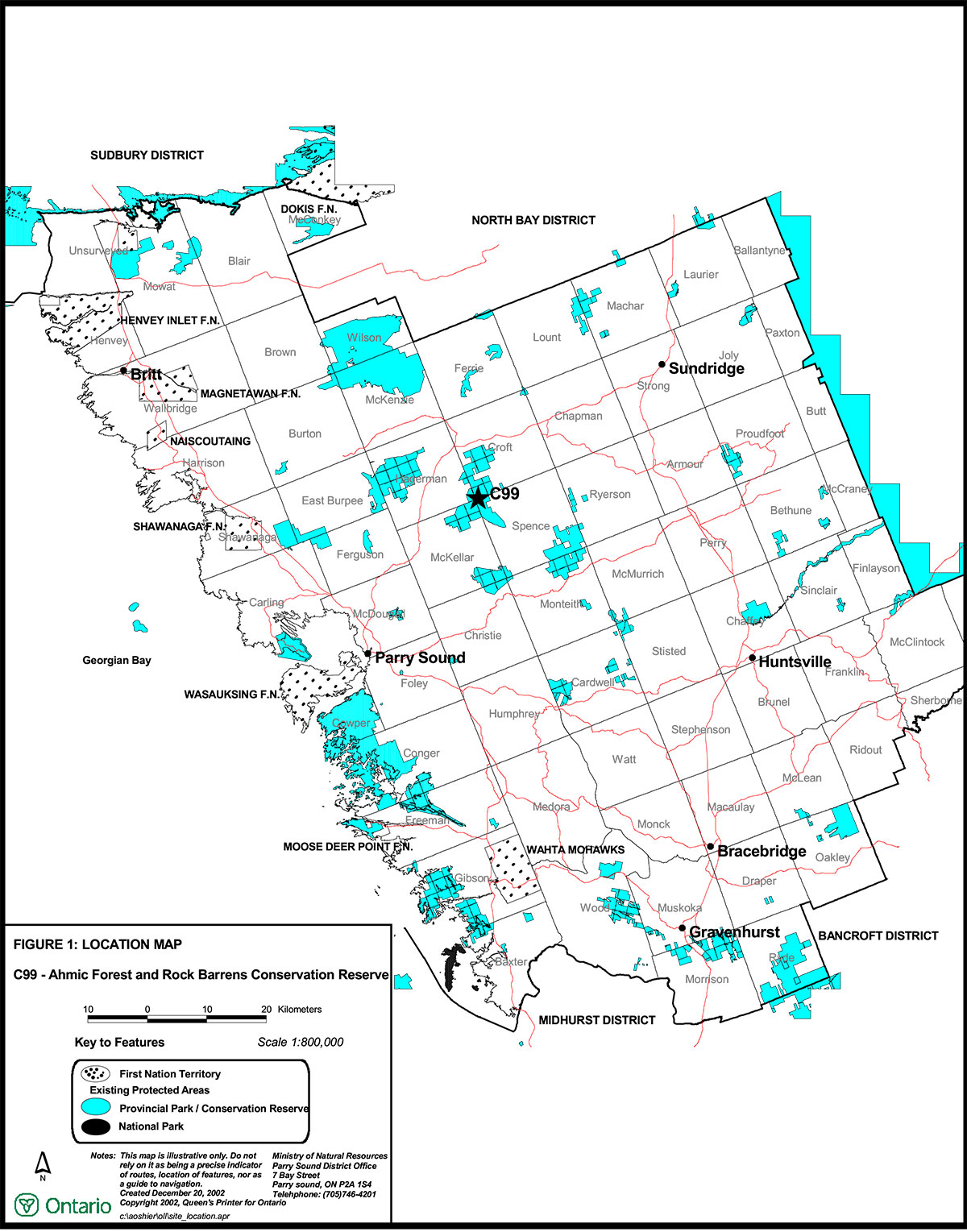
Figure 1. Location Map

Enlarge figure 1: Location Map
Figure 2.Site Map