Ballantyne Lake Drumlins Conservation Reserve Management Statement
This document provides policy direction for the protection, development and management of the Ballantyne Lake Drumlins Conservation Reserve and its resources.
Statement of Conservation of Interest
January 2005
Hearst District
Ministry of Natural Resources
Approval Statement
I am pleased to approve this Statement of Conservation Interest for the Ballantyne Lake Drumlins Conservation Reserve.
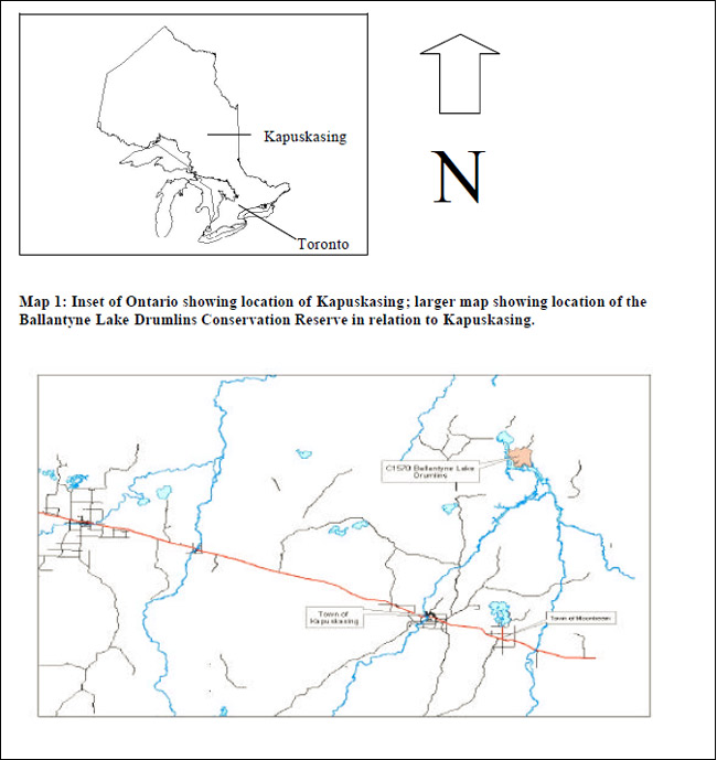
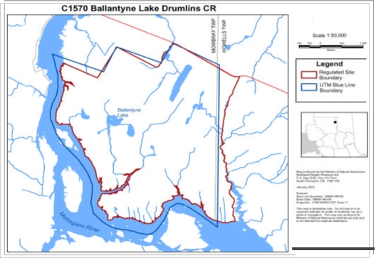
The Ballantyne Lake Drumlins Conservation Reserve totals 3,172 hectares in size and is found in the Smokey Falls 3E–1 Eco District, which is situated in the Lake Abitibi 3E Eco Region (Hills, 1959; Crins, 2000). The Reserve is 60 km north east of the Town of Kapuskasing within Mowbray and Howells Townships. The Ballantyne Lake Drumlins Complex Conservation Reserve is located within the Hearst District in the Northeast Region.
This site contains some exceptionally well developed examples of linear ice flow forms representing a late phase of the Cochrane Events environment during which glacial ice surged across the area in a fan shaped advance. Abundant ice–flow features ranging from drumlinoidal ridges to fluted forms are oriented southwest. The linear ice flow forms are composed of a carbonate rich, gravely silt till overlying an essentially massive, although fractured, silt unit. This site is associated with the lower Mattagami River Canoe Route.
Direction for establishing, planning and managing conservation reserves is defined under the Public Lands Act and current policy. "Ontario’s network of natural heritage areas has been established to protect and conserve areas representative of the diversity of the natural regions of the province, including species, habitats, features, and ecological systems which comprise that natural diversity." (Policy 3.03.05, MNR 1997). The specific direction for managing this conservation reserve is in the form of a basic SCI, which defines the area to which the plan applies, provides the purpose for which the conservation reserve has been proposed, and outlines the Ministry of Natural Resources' management intent for the protected area.
The public was informed and consulted prior to the regulation of the Ballantyne Lake Drumlins Conservation Reserve under the Public Lands Act as well as during the preparation and review of this Statement of Conservation Interest.
The Ballantyne Lake Drumlins Complex Conservation Reserve will be managed under the jurisdiction of the Hearst District Ministry of Natural Resources under the supervision of the Kapuskasing Area Office Supervisor as designated by the Hearst District Manager.
Compiled by:
Patrick Burrough
Recommended for approval by:
R. David Scott
District Manager
Hearst District
Date: March 24, 2005
Approved by:
Rob Galloway
Regional Director
Northeast Region
Date: April 10, 2005
1.0 Introduction
The Province of Ontario is home to a broad range of climate types, geography, and plant and animal species, all of which contribute to the variety and abundance of natural resources found here. The Ministry of Natural Resources is the lead conservation and resource management agency in the province and is therefore responsible for the management of these resources, in particular, forests, fisheries, wildlife, mineral aggregates and petroleum resources, Crown lands and waters, and provincial parks and protected areas MNR 2000).
The Ministry of Natural Resources (MNR) is committed to the protection of natural and cultural heritage values and as such has developed strategies that will maintain the integrity and sustainability of the parks and protected areas system. Recently the Government of Ontario conducted a major land use planning exercise, which resulted in the release of the Ontario’s Living Legacy Land Use Strategy (MNR 1999). The Land Use Strategy (LUS) focuses on four specific objectives that were established to guide the planning process. These are: to complete Ontario’s system of parks and protected areas; to recognize the land use needs of the resource–based tourism industry; to provide forestry, mining, and other resource industries with greater land and resource use certainty; and to enhance hunting, angling and other Crown land recreation opportunities.
The Ballantyne Lake Drumlins Conservation Reserve (C1570) was created as part of this expansion. As a result, the planning and management of this conservation reserve is consistent with the policies outlined in the Land Use Strategy. This conservation reserve is regulated under the Public Lands Act (PLA). Prior to its regulation, MNR met the Environmental Assessment Act requirements for the establishment and management of this conservation reserve.
Ontario’s network of natural heritage areas has been established to protect and conserve areas that represent the diversity of the natural regions of the province, including the species, habitats, special features and ecological systems which comprise that natural diversity. Protecting these natural heritage areas is the cornerstone to the sustainable management of natural resources. It ensures that representative sites are retained in their natural state and can continue to contribute to Ontario’s natural environment (MNR1997a).
In order to preserve these sensitive areas they require protection from incompatible uses to ensure their values will endure over time. Conservation reserves have been identified as a way of providing necessary protection from incompatible uses such as forestry and aggregate extraction, while still permitting many of the traditional uses that allow the people of Ontario to enjoy our special heritage. An approved Statement of Conservation Interest (SCI) or a Resource Management Plan (RMP) will guide the management and administration of each conservation reserve.
The management direction for this conservation reserve is a Statement of Conservation Interest. As a stewardship document, the SCI is the minimum level of management direction established for this conservation reserve. SCIs define the area that is being planned, the purpose for which the conservation reserve has been proposed, and it outlines the Ministry of Natural Resources' intent for the protected area. This SCI will govern the lands and waters within the regulated boundary of the conservation reserve. However, to ensure MNR protection objectives are being fully met within the conservation reserve, the surrounding landscape and related activities must consider the site’s objectives and heritage values. In addition, it is the intent of this SCI to create public awareness that will promote responsible stewardship of protected areas and surrounding lands. With management partners such as Ontario Parks, industry, local governments, etc. the MNR District Offices will be able to pursue and advance sound environmental, economic and social strategies and policies related to the protection of conservation reserves and provincial parks.
The purpose of this SCI is to identify and describe the values of the Ballantyne Lake Drumlins Conservation Reserve and outline the Ministry’s management intent. The management direction will protect the site’s natural heritage values for the benefit of all Ontario residents and demonstrate its compatibility within the larger sustainable landscape. This direction will comply with land use intent as stated by the Ontario’s Living Legacy Lands Use Strategy (MNR 1999).
The Ballantyne Lake Drumlins Conservation Reserve totals 3,172 hectares in size and is found in the Smokey Falls 3E–1 Eco District, which is situated in the Lake Abitibi 3E Eco Region (Hills, 1959; Crins, 2000). The Reserve is 60 km northeast of the Town of Kapuskasing within Mowbray and Howells Townships. The Ballantyne Lake Drumlins Conservation Reserve is located within the Hearst District in the Northeast Region. This site contains a provincially significant earth science site related to the Cochrane II Event sub–theme especially the southwest fluted till plain and iceberg keel marks.
Conservation reserves complement provincial parks in protecting representative natural areas and special landscapes. The guidelines for the management of this conservation reserve are found in this document.
2.0 Goals and Objectives
2.1 Goal of the Statement of Conservation Interest
The goal of a conservation reserve, as stated in Policy PL 3.03.05 (MNR 1997a), is to protect the natural heritage values on public lands while permitting compatible land use activities. The goal of this Statement of Conservation Interest is to provide the framework and direction to guide management decisions in order to ensure the Ballantyne Lake Drumlins Conservation Reserve will meet this goal through both short and long–term objectives.
2.2 Objectives
2.2.1 Short Term Objectives
Objective 1: To define the purpose for which the conservation reserve has been identified and to outline the Ontario Ministry of Natural Resources' management intent for the protected area.
Strategies:
- By identifying the state of the resource with respect to the natural heritage values being protected
- By identifying current land use activities that are occurring on the land base
Objective 2: To determine the best management strategy to protect the integrity of the values in the site.
Strategies:
- By determining the land use compatibility of current and potential land uses
- By developing specific guidelines and prescriptions to manage existing and potential land uses
Objective 3: To create public awareness of the values within this conservation reserve and promote responsible stewardship of the protected area.
Strategies:
- By creating fact sheets and pamphlets describing this conservation reserve and the resource(s) or values that it contains and protects
- By seeking partnerships with local stakeholders to ensure the values of the site are properly protected
This Statement of Conservation Interest meets the planning requirements for conservation reserves as determined in Procedure PL 3.03.05 which states that management plans must be written within three years of the regulation date (MNR 1997b ).
2.2.2 Long Term Objectives
Objective 1: To determine the long term management goals of the conservation reserve.
Strategies:
- By identifying the research needs, client services, and marketing strategies necessary to determine the position of this conservation reserve among the system of parks and protected areas in Ontario
Objective 2: To determine the representative targets of the site.
Strategies:
- By identifying the scientific values in relation to provincial benchmarks
- By identifying any monitoring or research necessary to identify and maintain the integrity of these characteristics beyond this plan
Objective 3: To provide direction for the evaluation of new uses or economic ventures proposed.
Strategies:
- A Test of Compatibility shall be undertaken to evaluate the impact of suggested use(s), either positive or negative, on the protected values and administrative needs of the conservation reserve
3.0 Management Planning
3.1 Planning Context
3.1.1 Planning Area
The planning area for this site will consist of the regulated boundary for the Ballantyne Lake Drumlins Conservation Reserve as defined in section 4.1.3 Administrative Description. This land base will form the area directly influenced by the Statement of Conservation Interest. It is also recognized that the surrounding landscape and related activities must carefully consider the site’s values to ensure that the protection objectives are being fully met within the conservation reserve. The Ministry of Natural Resources, in conjunction with other partners, will work to ensure that the values are protected during additional planning and implementation of activities on the intervening landscape. Any strategies noted within this plan related to the site’s boundary or beyond will need to be presented for consideration within a larger planning context.
3.1.2 Management Planning Context
The Ontario Living Legacy Land Use Strategy (1999) describes the Ballantyne Lake Drumlins Conservation as containing a provincially significant earth science site related to the Cochrane II Event sub–theme especially the southwest fluted till plain and iceberg keel marks. The site was then regulated as Schedule 59?, in Ontario Regulation 686/00? made under the Public Lands Act, December 20, 2000? and filed December 21, 2000? amending Ontario Regulation 805/94? (Conservation Reserves).
Once a Conservation Reserve is passed into regulation, it must be determined what level of management planning is required to fulfill the protection targets. This Statement of Conservation Interest will only address known issues or current proposals with respect to permitted uses or potential economic opportunities brought forward during this planning stage. However, in terms of approving future permitted uses and/or development(s), there are established mechanisms in place to address such proposals. Any future proposals will be reviewed using the Procedural Guideline B – Land Uses – Test of Compatibility Public Lands Act Policy PL 3.03.05 (MNR 1997) or other MNR environmental screening processes (see Appendix B).
Consideration for proposals pertaining to cultural resources may be screened through Conserving a Future for our Past: Archaeology, Land Use Planning & Development in Ontario, Section 3 (MCzCR, 1997) and MNR's history in establishing Area of Concern (AOC) descriptions and prescriptions for cultural heritage resources within forest management plans (FMPs).
These planning tools will help refine the review process once the proposal satisfies the direction and intent of the Public Lands Act, associated policies and this planning document.
3.2 Planning Process
There are two policy documents that address the planning process; a Statement of Conservation Interest (SCI) is the minimal requirement for providing planning direction and a Resource Management Plan (RMP) that deals with more complex issues (where several conflicting demands are placed on the resources). The guidelines for the preparation of these documents are outlined in Procedural Guideline A – Resource Management Planning (Conservation Reserves Procedure PL 3.03.05 Public Lands Act). The appropriate plan must be completed within three years of the regulation date.
For current planning purposes, the Ballantyne Lake Drumlins Conservation Reserve will be managed under the auspices of a Statement of Conservation Interest. Interested parties from both the private and public sectors were consulted during the Ontario’s Living Legacy (OLL) planning process from candidate conservation reserve to regulation. The public was consulted during the conservation reserve’s creation and final regulation. The responses and concerns brought forward during that consultation period are reflected in this Statement of Conservation Interest.
Public consultation will be solicited during a review of any future land use proposals that would require new decisions to be made.
The SCI is a policy document that will provide background information, identify values to be protected and establish management guidelines for use in the administration of the reserve.
The implementation of the policy will be the mandate of the MNR at the district level, however associations with various partners may be sought to assist in the delivery. It must be noted that this SCI is a working document and it will be necessary to make revisions to it from time to time.
As part of public consultation, initial consultation was solicited from the public, First Nation communities, and stakeholders that may have an interest in the conservation reserves in the Hearst District by means of direct mail. Also, newspaper ads were placed in six local papers in Kapuskasing, Heasrt, Chapleau, Cochrane and Timmins that may have an interest in the conservation reserves in the Hearst District. They are listed below:
- LeNord (Hearst) – French
- The Weekender (Hearst/Kapuskasing) – French & English
- Northern Times (Kapuskasing) – English
- Chapleau Express – English
- Timmins Daily Press – English
- Cochrane Times Post – English & French
The purpose of the consultation was to notify that the management planning for the six conservation reserves within the Hearst District was beginning and:
- MNR is collecting comments and information regarding these SCIs to assist in making decisions and determining future public consultation needs
- Respondents will be notified when the draft statements of conservation interest are available for review. At that time a copy of the draft would be provided to interested persons or organizations upon request
The Ministry of Natural Resources is exempt from providing notification of this planning process on the Electronic Bulletin Registry, under Section 30 of the Environmental Bill of Rights (EBR). Note that public consultation will be solicited during a review of any future land use proposals that would require new decisions to be made. In addition, any future proposal and/or any new, significant management direction considered will be published on the Environmental Bill of Rights registry (EBR).
4.0 Background Information
4.1 Location and Site Description
4.1.1 Location
| Name | Ballantyne Lake Drumlins Conservation Reserve |
|---|---|
| Eco–Region / Eco District (Hill 1959) | 3E–1 (Hills, 1959; Crins, 2000) |
| Eco–Region / Eco District (Crins and Uhlig 2000) | Lake Abitibi 3E Smokey Falls Ecodistrict 3E–1 |
| MNR Administrative Region / District Area | Northeast Region / Hearst |
| Size | 3,172 ha |
| Nearest Town | Kapuskasing |
| Townships | Mowbray, Howells |
| UTM Ref. | 420553 |
| Map Name | 42G/16 |
| Latitude / Longitude | 49° 55' 28"N 82° 06' 28"W |
| Elevation | Minimum: 200m Maximum: 200m |
| Watershed | Moose River Basin |
| Wildlife Management Unit | WMU 24 |
| Forest | Gordon Cosens Forest |
Table 1: Location and administrative details for the Ballantyne Lake Drumlins Conservation Reserve
4.1.2 Physical Site Description
The Ballantyne Lake Drumlins Conservation Reserve is located approximately 60 km northeast of the town of Kapuskasing and consists of 3,172 hectares of land. This site is found within Mowbray and Howells Township in the District of Hearst. The Conservation Reserve is located in the Smokey Falls Site District 3E–1, which is within the Lake Abitibi Site Region. The Lake Abitibi Site Region is characterized by moderately to gently rolling bedrock, generally covered by deep deposits of clay, silt and sand (Hills, 1959). The Smokey Falls Site District is characterized by a smooth plain of clay and loam, moderate to high in lime, shallow to moderately deep over bedrock with a fairly high percentage of muskeg. The forest climate for the site is mid–humid, mid–boreal (Hills, 1959; Poser, 1992). Currently Crins (2000) places the site within the new 3E–1 Ecodistrict, which generally comprises old Site Districts 3E–1 and 3E–3.
The Ballantyne Lake Drumlins Conservation Reserve is composed of biological, cultural and vectored1 boundaries. The biological boundaries for the site include the Mattagami River, which borders the west, south and southeastern corner of the site. In addition a creek system acts as a boundary for the remaining eastern side of the site and a shoreline of a small unnamed lake acts as a boundary for a small portion of the north. The cultural boundary includes a tertiary road that runs along the northeastern corner of the site. Finally, the remaining areas of the north are contained by vectored boundaries.
This conservation reserve is found within Rowe’s (1972) Northern Clay Boreal Forest Section and is inhabited by black spruce stands, which occupy both the rising uplands and on the lowland flats coexisting with sedge fens and sphagnum–heath bogs. Black spruce commonly occurs with cedar in swamp areas mainly in the west, but the cedar are most dominant along the borders of the swamps since this is where they reach tree size. Areas that display examples of shallowly buried coarse drift or that are located in close proximity to lakes and rivers show examples of hardwood or mixed wood communities such as trembling aspen, balsam poplar, balsam fir, white spruce and black spruce. Areas that are drier in nature such as old beaches, eskers, and outwash deposits exhibit stands of jack pine and white birch are found on sandy soils.
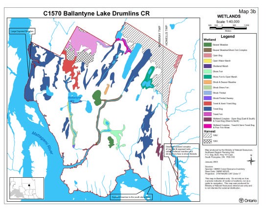
During the aerial reconnaissance survey a number of wetlands were observed with well stocked treed bogs and semi treed bogs dominating much of the large organic deposits throughout the site with shrub and peat shore fens, beaver meadows, poor fens dominating major creeks and inland waterways (Map 3b – Wetlands).
4.2 Administrative Description
The legal description of the Ballantyne Lake Drumlins Conservation Reserve, regulated as Schedule 59 in Ontario Regulation 686/00 made under the Public Lands Act on March ?, 2004 and filed on March ?, 2004 amending Ontario Regulation 805/94.
The Ballantyne Lake Drumlins Conservation Reserve is located within the Ministry of Natural Resources, Hearst District administrative area and within the legal boundaries of the Gordon Cosen Forest Sustainable Forest License area.
4.3 History of the Site
The site is considered to be in good condition although a portion of the northern section of the site has been harvested in the past. The aerial reconnaissance survey showed that these harvest areas have been replanted with spruce (Thompson 2001). A road forms part of the boundary for the northeastern part of the site and there is an existing Trapper’s Cabin on a small bay of the Mattagami River.
This conservation reserve is also associated with four hydro dam sites as part of the Mattagami River watershed.
4.4 Inventories
Table 2 indicates the current status of natural heritage inventory that has occurred or that will be required in the near future.
Table 2: Inventory and Survey Information for Ballantyne Lake Drumlins Conservation Reserve
| Survey Level | Earth Science | Life Science | Cultural | Recreational | Other |
|---|---|---|---|---|---|
| Reconnaissance | Kristjansson and Kor (1997) | 2001(Thompson) Aerial reconnaissance Survey | N/A | 2001 – Malenfont, C. and M. Silver. | N/A |
| Detailed | N/A | N/A | N/A | N/A | N/A |
| Further Requirements |
N/A | N/A | N/A | N/A | Need Global Positioning of the location of roads & trails currently present within the site. |
5.0 State of the Resource
Representation
The Ballantyne Lake Drumlins Conservation Reserve is comprised of 3,172 hectares and is located approximately sixty kilometers north of Kapuskasing within Mowbray and Howells town ships. The site is composed of both biological boundaries. Access to the interior of the site if restricted but access to the outer limits of the site can be gained through the adjacent Mattagami River and by a road running along the northeast corner of the site. This earth science site was originally identified by Kristjansson and Kor (1997) and was brought forward as a candidate earth science site by the Boreal East Round Table for protection during the Lands For Life land use planning exercise.
This conservation reserve is found in the Smokey Falls Site District 3E–1, which is within the Lake Abitibi Site Region. The Lake Abitibi Site Region is characterized by moderately to gently rolling bedrock, generally covered by deep deposits of clay, silt and sand (Hills, 1959). The Smokey Falls Site District is characterized by a smooth plain of clay and loam, moderate to high in lime, shallow to moderately deep over bedrock with a fairly high percentage of muskeg. The forest climate for the site is mid–humid, mid–boreal (Hills, 1959; Poser, 1992). Currently Crins (2000) places the site within the new 3E–1 Ecodistrict, which generally comprises old Site Districts 3E–1 and 3E–3.
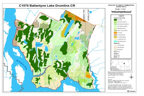
The provincial landform database states this site to be completely inundated with weakly broken end moraine. Kristjansson presented a preliminary analysis of the landforms for this site with Kor in 1997 (Kristjansson and Kor 1997) and again in a more resent analysis (Kristjansson, in prep.) and showed the site to contain scattered arrangements of till deposits with silty sand till and lineated till plain–glaciolacustrine deposits combinations, till deposits with silt to sandy silt till and glaciolacustrine with silty fine sand. Interspersed within these arrangements are organic deposits found in pockets around the site. This interpretation is significantly different and more complex than that of the provincial landform coverage (Map 1b – Landforms).
This conservation reserve is found within Rowe’s (1972) Northern Clay Boreal Forest Section and is inhabited by black spruce stands, which occupy both the rising uplands and on the lowland flats coexisting with sedge fens and sphagnum–heath bogs. Tamarack is an occasional associated with the black spruce. Black spruce commonly occurs with cedar in swamp areas mainly in the west, but the cedar are most dominant along the borders of the swamps since this is where they reach tree size. Areas that display examples of shallowly buried coarse drift or that are located in close proximity to lakes and rivers show examples of hardwood or mixed wood communities such as trembling aspen, balsam poplar, balsam fir, white spruce and black spruce. Areas that are drier in nature such as old beaches, eskers, and outwash deposits exhibit stands of jack pine and white birch are found on sandy soils (Rowe, 1972).
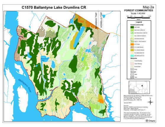
No life science gap analysis was conducted for this conservation reserve, since originally the site was a provincially significant earth science site. The FRI data and our interpretation of this data showed this conservation reserve to be dominated by black spruce and poplar communities with a good portion of wetlands (Map 2a – Forest Communities). The black spruce communities are far more prevalent within the site and comprise of pure conifer2, dominant conifer, predominant conifer, conifer mixed, mixedwood3 and black spruce/poplar true mixed stands. These black spruce stands inhabit most of the landforms associated with the site including organic deposits but are somewhat absent along a few of the site’s boundaries. The poplar communities in the conservation reserve are found making up pure, dominant hardwood, hardwood mixed and mixedwood stands. These stands for the most part can be found situated along the boundaries of the site including the northeast corner, the portion of the southeast corner, the south, the entire western boundary and a portion of the northwest corner generally on till and glaciolacustrine deposits. There is also a poplar mixedwood stand located in the central west part of the site associated with Ballantyne Lake. The FRI data also show two white birch stands within the site but these stands are so small that they are not visible on the forest communities map (Map 2a).
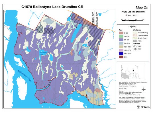
The majority of the site’s forest communities tend to be classified as mature with communities between 60–89 years (Map 2c – Age Distribution). The small amount of old growth on the site can be mostly found at 90–119 years or 120–149 years of age and are represented by black spruce mixedwood stands and poplar mixedwoods. If the site continues to receive protection many of the poplar and mixedwood stands will approach old growth in 10 to 20 years with black spruce lowland communities changing to old growth in approximately 40 years. Lastly, there are a few forests aged between 0–29 years representing pure poplar stands along the northeast boundary; however a large portion of the northeast corner was harvested between 1992 and 1993 and that disturbance is not reported on Map2c. The aerial reconnaissance survey showed that these clear–cut areas have been replanted with spruce and are in the process of regenerating (Thompson 2001).
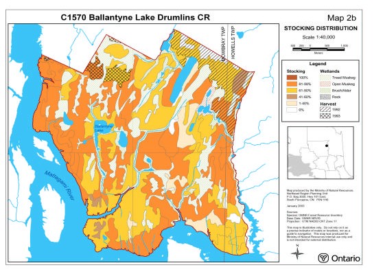
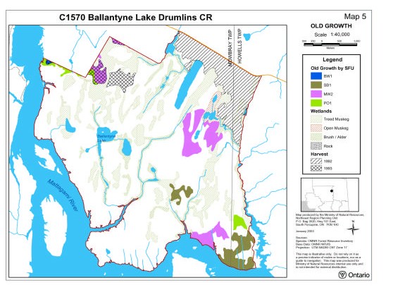
The stocking for this site can be considered quite high with the majority of the site stocked either between 61–80 percent or 81–99 percent. A small portion of the site is stocked between 1–40 percent and 41–60 percent (Map 2b – Age Distribution). Some of the best examples of poorer stocked areas include spruce fir mixedwood stands (MW2) old growth sites and old growth lowland black spruce and black spruce semi treed bog areas (Map 5 – Old Growth).
During the aerial reconnaissance survey a number of wetlands were observed with well stocked treed bogs and semi treed bogs dominating much of the large organic deposits throughout the site with shrub and peat shore fens, beaver meadows, poor fens dominating major creeks and inland waterways (Map 3b – Wetlands). The survey also showed there to be an extensive arrangement of cattail marshlands, which are separated by large sand flats in the southeastern corner of the site that are disturbed as a result of hydro controlled waters on the Mattagami River. Furthermore, open water and sheltered marshes areas are located along the southern shores of Ballantyne Lake located in the western part of the site. In summary not all wetlands were classified during the aerial reconnaissance survey since wetlands were numerous and time afforded for their classification was limited. The FRI data (Map 2a – Forest Communities) showed the dominant wetlands to be treed muskeg, open muskeg and brush alder which generally corresponds to the wetland classification that was achieved during the aerial reconnaissance flight.
The Ballantyne Lake Drumlins Conservation Reserve falls in the Moose River Bas in, in tertiary watershed 4LG (OMNR, 2000). This conservation reserve is found adjacent to Mattagami River, which forms the site’s western and southern boundaries. Other lakes include Ballantyne lake in the west and a few other unnamed lakes and creeks throughout the rest of the site.
Wildlife values for this site include two traplines (KA–76) (KA–68), one bear management area and baitfish area.
Quality of Present Representation
a) Diversity
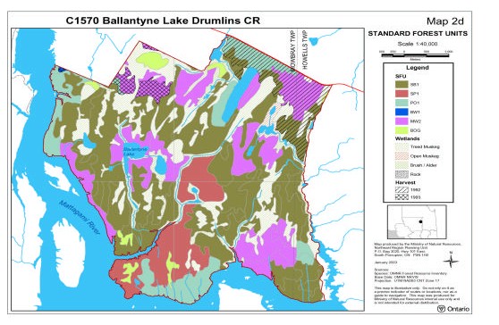
Diversity is a measure of the site’s life and earth science heterogeneity. It is based on the number and range (variety) of the natural landscape features and landforms of earth science values and the richness and evenness of the life science component. When looking at combinations of forest communities within the site (Map 2a ) the diversity is considered to be low taking into account that the forest communities are dominated by black spruce conifer and mixedwood stands and poplar hardwood and mixedwood stands.
A more ecological grouping of the FRI based on Standard Forest Units (SFUs, Map 2d) was constructed; though the diversity of landforms and vegetation combinations precluded a quantitative landform: vegetation analysis until the landforms have been digitized. However, looking at the few landforms identified by Kristjansson (in prep.) and SFUs presented (Map 2d) much of the area is further simplified with lowland black spruce on till and glaciolacustrine deposits dominating much of the site. A large area of spruce mixedwoods (SP1) with scattered mixedwoods (MW2) and poplar stands (PO1) are also present but do not add much to the diversity of the site. By adding in the wetland communities, development stages and the irregular shaped earth science features interpreted by Kristjansson (in prep.) the life science diversity of the site will probably not increase substantially. Life science diversity was expected to be rather low since the site was originally an earth science site.
b) Ecological Factors
Wherever possible, a site’s boundaries should be created to include the greatest diversity of life and earth science features to provide the maximum ecological integrity. It should be ecologically self–contained, bounded by natural features and include adequate area to buffer the core ecosystems from adjacent land use activities (OMNR, 1992). The Ballantyne Lake Drumlins Conservation Reserve is composed of biological, cultural and vectored boundaries. The biological boundaries for the site include the Mattagami River, which borders the west, south and southeastern corner of the site. In addition a creek system acts as a boundary for the remaining eastern side of the site and a shoreline of a small unnamed lake acts as a boundary for a small portion of the north. The cultural boundary includes a tertiary road that runs along the northeastern corner of the site. Finally, the remaining areas of the north are contained by vectored boundaries.
Currently we do not have minimum size standards for conservation reserves under different landscape conditions. However, a minimum size standard of 2000 ha has been established for natural environment parks by Ontario Parks (OMNR, 1992). This minimum standard was considered necessary to protect representative landscapes as well as allow for low intensity recreational activities. The Ballantyne Lake Drumlins Conservation Reserve is comprised of 3,172 ha and therefore meets this minimum standard. Given the relatively large size of this site, the overall configuration of the site and the strong presence of biological boundaries increase the site’s ability to protect the representative values found within the reserve. Furthermore, the potential for low intensity recreational activities is good for this reserve considering it is adjacent to Mattagami River Provincial Canoe Route and it contains a number of inland lakes.
c) Condition
The site is considered to be in good condition although a lot of the northern section of the site has been cut in the past. The aerial survey observed some old white birch stags in portions of the cut areas but forest regeneration is occurring. The majority of the northeastern old cut has been replanted with spruce and is regenerating. There has also been some cutting along the northwestern section of the site.
d) Special Features
Special features for the site are the provincially significant earth science features and landscapes noted by Kristjansson and Kor (1997) that are tied to the Cochrane II Event sub–theme – especially the southwest fluted till plain and iceberg keel marks. Recreationally, the site’s association with the Mattagami River Canoe Route and that river’s linkage with the Groundhog River, an OLL provincial park, allow for extensive outback recreation including potential canoeing, camping, fishing and other recreational activities near, adjacent and on site.
e) Current Land Use Activities
Current land use activities within or near the conservation reserve includes trapping, snowmobiling, fishing, hunting, canoeing, and kayaking. The potential for low intensity recreational activities is good for this reserve considering it is adjacent to Mattagami River Provincial Canoe Route and it contains a number of inland lakes.
5.1 Social/Economic Interest in the Area
a) Linkage to Local Communities
The Ballantyne Lake Drumlins Conservation Reserve located approximately 60 kilometres northeast of Kapuskasing offers the potential for low intensity recreational activities including canoeing, camping, fishing and other recreational activities (e.g. bird watching, photography or nature study). Also of significance, the Ballantyne Lake Drumlins Conservation Reserve is associated with the Mattagami River Canoe Route and the river’s linkage with the Groundhog River, an OLL provincial park will enhance current recreational potential.
b) Heritage Estate Contributions
The Ballantyne Lake Drumlins Conservation Reserve contributes to the province’s Parks and Protected Areas System through its regulation, representation and the long–term management of natural heritage values. By allocating these lands to the Parks and Protected Areas System, the province has ensured a certain level of permanence by distinguishing the site and its values from the broader general use or more extensively managed landscape. In addition, its natural features are, and will be available for present and future generations to enjoy and explore.
c) First Nations
The Ballantyne Lake Drumlins Conservation Reserve lies within the Nishnawbe–Aski Nation (N.A.N) Treaty # 9 Area. The protection of this area as a conservation reserve and the Statement of Conservation Interest are not meant to infringe on the Treaty and Aboriginal Rights of any First Nation in any way. Traditional uses such as hunting, fishing, trapping and gathering will be respected. At the present time, there are no known land claims by First Nations for the area in question.
d) Mining Interests
This conservation reserve has no mining tenure within it. Mining and surface rights have been withdrawn from staking within the conservation reserve boundaries under the Mining Act (RSO 1990 Chapter M.14). Mining will not occur in any regulated protected area.
e) Forest and Fire Management History
The MNR recognizes fire as an essential process fundamental to the ecological integrity of conservation reserves. In accordance with existing Conservation Reserve Policy and the Forest Fire Management Strategy for Ontario, forest fire protection will be carried out as on surrounding lands.
Whenever feasible, the MNR fire program will endeavour to use "light on the land" techniques, which do not unduly disturb the landscape, in this conservation reserve. Examples of light on the land techniques may include limiting the use of heavy equipment or limiting the number of trees felled during fire response efforts. Opportunities for prescribed burning to achieve ecological or resource management objectives may be considered. These management objectives will be developed with public consultation prior to any prescribed burning, and reflected in the document that provides management direction for this conservation reserve. Plans for any prescribed burning will be developed in accordance with the MNR Prescribed Burn Planning Manual, and the Class Environmental Assessment for Provincial Parks and Conservation Reserves.
f) Other Government Agencies, Departments or Crown Corporations
Other Government Agencies that may have an interest in the site include the Ministry of Citizenship (MCzP), the Ministry of Tourism, Culture and Recreation (MTCR). Although there are no known cultural heritage values present at this time if values were identified in the site the MNR would work with the MCzP to ensure proper protection of any cultural heritage resources. The MNR will also work in conjunction with the MTCR to identify/enhance any potential tourism opportunities, in particular where resource–based tourism (RBT) potential is identified. RBT operations include hunting and fishing as well as eco–tourism opportunities. Proper evaluation will be undertaken where opportunities are identified to ensure consistency with the management policies of this conservation reserve.
5.2 Natural Heritage Stewardship
Special features for the site are the provincially significant earth science features and landscapes noted by Kristjansson and Kor (1997) that are tied to the Cochrane II Event sub–theme – especially the southwest fluted till plain and iceberg keel marks.
No life science gap analysis was conducted for this conservation reserve, since originally the site was a provincially significant earth science site.
5.3 Fisheries and Wildlife
Wildlife values for this site include two traplines (KA–76) (KA–68), one bear management area and baitfish area.
It is not known if any vulnerable, threatened or endangered species exist on or near the site. Further detailed habitat studies may be warranted.
5.4 Cultural Heritage Stewardship
There are no known cultural heritage values within the Ballantyne Lake Drumlins Conservation Reserve and no detailed research has been conducted as of this date to document possible cultural heritage values.
If archaeological/ cultural resources are discovered within the conservation reserve proposals pertaining to the development/use of these cultural resources may be screened through direction provided in Conserving a Future For Our Past: Archaeology, Land Use Planning & Development In Ontario (MCzCR 1997).
5.5 Land Use/Current or Past Development
This conservation reserve rest entirely on Crown land and is unencumbered by any land use permits, licences of occupations, leases or mining claims. There is no mining tenure near the site and no mines have been developed on the site in the past.
5.6 Commercial Use
This site includes two traplines (KA–76) (KA–68), one bear management area and baitfish area.
5.7 Tourism/Recreational Use/Opportunities
The impact of human recreational activities within the bounds of the conservation reserve is also anticipated to have a minimal impact on the site’s ability to maintain its c ore values over the long–term.
5.8 Client Services
Currently visitor services at the MNR Kapuskasing Area Office, Hearst District Office are limited to responding to inquiries about access, natural heritage features and boundaries. No formal information or interpretive facilities currently exist within the conservation reserve.
Other client services include providing clients with maps, fact sheets and other information gathered on the area, such as the Earth, Life and Recreational Inventory work.
Management Guidelines
6.1 Management Planning Strategies
The land use intent outlined in the OLL Land Use Strategy (MNR 1999) provides context and direction to land use, resource management, and operational planning activities on Crown land. Commitments identified in the above strategy and current legislation (Policy 3.03.05 PLA) will form the basis for land use within Ballantyne Lake Drumlins Conservation Reserve. Management strategies for these uses must consider the short and long–term objectives for the reserve. For up to date information on permitted uses refer to the Crown Land Use Atlas.
Protected areas will be managed to retain and/or restore natural features, processes and systems. They will also provide opportunities for compatible research, education and outdoor recreation activities (MNR 1997c). Proposed uses and development will be reviewed on a case–by–case basis. A Test of Compatibility, (Procedural Guidelines B – Land Uses PL 3.03.05) must be passed before they are deemed acceptable. The emphasis will be on ensuring that the natural values of the conservation reserve are not negatively affected by current and future activities. Therefore any application for new specific uses will be carefully studied and reviewed via the above environmental screening process.
Management strategies will also be consistent with the objectives of increasing public awareness, promoting responsible stewardship, providing marketing opportunities, and identifying inventory, monitoring, and research opportunities .
6.2 "State of the Resource" Management Strategies
The development of this SCI and the long–term management and protection will be under the direction of the MNR's Kapuskasing Area Office Supervisor, Hearst District. The following section will deal with the management strategies that are specifically laid out to maintain, protect and enhance the existing natural heritage values and land use activities of the Ballantyne Lake Drumlins Conservation Reserve.
Natural Heritage Values
The management intent for the Ballantyne Lake Drumlins Conservation Reserve will be to allow for natural ecosystems, processes and features to operate undisturbed with minimal human interference while providing educational, research and recreational activities. Forest ecosystem renewal will only be considered as separate vegetative management plan.
Forest fire protection will be provided as per fire strategies used on surrounding public lands, under the direction of the provincial fire strategy. All wildfire occurrences will be considered a high priority and will actively be suppressed. Prescribed burning will be conducted only under the direction of the provincial fire strategy and authorized for the conservation reserve under a separate vegetative management plan. Prescribed burning may be utilized if deemed necessary to emulate natural disturbances and renew forest communities, prepare seed beds for research and/or education purposes or to meet additional objectives determined within a separate vegetative management plan. Consideration for the life science values will be the governing priority in any future vegetative management plan.
Defining compatible uses, enforcing regulations and monitoring and mitigating issues will protect all earth and life science features. Industrial activities such as commercial timber harvest and new hydro generation will not be permitted within the conservation reserve. Extraction of unconsolidated sand, gravel, soils or peat is not permitted. Energy transmission, communication and transportation corridors or construction of facilities are discouraged within the boundaries of the conservation reserve. Such structures negatively impact on the quality of representation features that require protection. Alternatives should be reviewed by means of larger landscape planning processes. New roads for resource extraction and/or private use will not be permitted. Other activities that do not pass a Test of Compatibility will be prohibited (MNR 1997a).
The introduction of exotic and/or invasive species will not be permitted. Programs may be developed to control forest insects and diseases where there is a concern that significant values may be compromised. Remedies must focus on the outbreak or infestation. Native biological or non–intrusive solutions should be applied whenever possible.
The collection/removal of vegetation and parts thereof may be permitted subject to a Test of Compatibility, the Area Supervisor may authorize such activities for purposes of wild rice harvesting, food harvesting, removing exotic species, rehabilitating degraded sites within the reserve, collecting seeds for maintaining genetic stock and/or for inventory or research. The cutting of trees for non–commercial purposes (e.g. fuel–wood) is not permitted.
MNR will provide leadership and direction for maintaining the integrity of this site as a heritage estate. To ensure MNR protection objectives are being fully met within the conservation reserve, activities on the surrounding landscape should consider the site’s objectives, heritage values and the design flaws currently present. MNR via input and plan review will ensure the conservation reserve’s values are considered in local and adjacent land use strategies and plans. Research, education and interpretation will be encouraged to provide a better understanding of the management and protection of the natural heritage values and will be fostered through local and regional natural heritage programs, initiatives and partnerships.
Fisheries and Wildlife
Sport fishing and hunting will be permitted within this conservation reserve. Fishery and wildlife resources will continue to be managed in accordance with specific policies and regulations defined by the Ontario Ministry of Natural Resources under the Fish and Wildlife Conservation Act and the Kapuskasing Area Office Supervisor. Management of these resources will have consideration for the earth and life science features contained within the site.
Cultural Heritage Values
It is not known if cultural heritage values exist in the Ballantyne Lake Drumlins Conservation Reserve, however, if values are confirmed management would be consistent with Conserving a Future For Our Past: Archaeology, Land Use Planning & Development In Ontario (MCzCR 1997).
Land Use/Past and Existing Development
The sale of lands within the conservation reserve is not permitted as per the OLL LUS (MNR 1999). No new recreational camps will be permitted. Road realignments, telecommunications and other resource networks will be discouraged from crossing the site and interrupting the conservation reserve’s natural state. New roads for resource extraction and/or private use will not be permitted.
Through the Ministry’s plan input and review program, applications for more intense use will be reviewed to ensure natural heritage values within the conservation reserve are considered and protected in planning decisions on adjacent private land.
Any new developments (e.g. tourism developments) proposed for the conservation reserve must go through a Test of Compatibility to ensure that the activity is permitted and to ensure the natural heritage values within the site are protected. If a proposal is considered, public consultation may be required. If accepted, an amendment of the SCI would be required.
Commercial Activities
Commercial, non–industrial activities such as fur harvesting, baitfish harvesting and Bear Management Areas will be managed according to prescriptions in the Land Use Strategy (MNR 1999). Fur harvesting traplines and bait fishing operations will be permitted to continue since there are no demonstrated conflicts between these activities and the values being protected. New operations would be subjected to a Test of Compatibility to ensure that the wildlife populations could sustain additional activity. Existing Bear Management Areas (BMAs) will be permitted to continue, however, new operations will not be permitted as per the Land Use Strategy (MNR 1999). MNR managers will work with operators to ensure that the natural heritage values within the conservation reserve are respected.
Aboriginal Interests
Traditional activities and aboriginal rights as defined in the Nishnawbe–Aski Nation (N.A.N) Treaty # 9 Area and other relevant Acts will not be affected within the boundaries of this conservation reserve.
Tourism and Recreation
The earth and life science features and their protection shall be the overall theme for tourism and recreation within the conservation reserve. Future economic or development proposals should go through a Test of Compatibility to ensure the natural heritage features are well protected. Future trail development must consider the values found within the boundaries of the site, the rationale for developing trails within the site and the availability of current access through the site and surrounding areas. Furthermore, any new trail development will require a 'Test of Compatibility'. Sensitive areas previously discussed should be avoided.
Client Services
Under the direction of the Kapuskasing Area Supervisor, Hearst District natural heritage staff will respond to public, non–government organizations (NGOs), industry and MNR partner requests for basic information on the site. Such requests could include but are not limited to the following; regulated boundaries, values, current access and infrastructure, permitted uses, role that Ballantyne Lake Drumlins Conservation Reserve plays as a natural heritage estate and within the greater provincial parks and protected area system and any additional information that is required to meet good customer service.
6.3 Promote Inventory Monitoring and Assessment Reporting and Research
Scientific research by qualified individuals or institutions, which contributes to the knowledge of natural and cultural history and to environmental and recreational management, will be encouraged. Research programs will be subject to ministry policies and other legislation.
Approved research activities and facilities will be compatible with the protection objective. Any inventory, monitoring, assessment reporting or research developments or facilities will not be considered until a Test of Compatibility is conducted and proposal is approved by the Kapuskasing Area Supervisor, Hearst District.
To advance conservation reserve custodial management, future managers will need to monitor the current state of the conservation reserves resources at least at the community and landscape levels within and adjacent to the conservation reserve and its surrounding environment. Such monitoring could include: evaluating and reporting on changes such as; natural disturbances (i.e. fire, insect/ disease, wind throw, etc.), human disturbances (i.e. forest harvesting, access and/or other land use activities) as well as management prescriptions (i.e. rehabilitation efforts and/or vegetative management planning).
Ongoing evaluations and reports will have to rely on current and new technologies such as satellite imagery, global positioning systems (GPS), supplementary aerial photography (SAP) and/or aerial/ground reconnaissance surveys/assessments conducted periodically and placed within a GIS database. Such tools could help managers spatially record affected areas, severity of perturbations or management action as well as consider the sensitivity of values, the design of the CR and determine the future desired condition of the site. Monitoring efficiencies could be enhanced via partnerships and internal coordination within MNR.
6.4 Implementation and Plan Review
Implementation of this SCI will primarily involve monitoring activities to ensure adherence to the management guidelines. Other activities may include funding future life and earth science inventories and responding to inquiries about the site.
Implementation of the SCI and management of the reserve are the responsibility of the Area Supervisor. Partnership may be pursued to address management needs. Ballantyne Lake Drumlins Conservation Reserve SCI will be reviewed on an ongoing basis. If changes in management direction are needed at any time, the significance of the changes will be evaluated. Minor changes, which do not alter the overall protection objectives, may be considered and approved by the Area Supervisor without further public consultation and the plan will be amended accordingly. In assessing major changes, the need for a more detailed Resource Management Plan will first be considered. Where a management plan is not considered necessary or feasible, a major amendment may be considered with public consultation. The Regional Director will approve major amendments.
6.5 Marketing
No active marketing of this conservation reserve is anticipated.
7.0 References
Arnup, R., G.D. Racey and R.E. Whaley. 1999. Training manual for photo interpretation of ecosites in northwestern Ontario. NWST Technical Manual TM– 003.127p.
Bridge, S., R. Watt, G. Lucking and B. Naylor. 2000. Landscape analysis for forest management planning in boreal northeastern Ontario. OMNR, Northeast Science and Technology. 36p.
Crins, W.J., 2000. Ecoregions of Ontario: modifications to Angus Hills' Site Regions and Site Districts revisions and rationale.
Ritchie, G. and J. Thompson. 1998. Lands for Life natural heritage reference binder Boreal East Planning Area. OMNR internal report.
Hills, G.A., 1959. A steady reference to the description of the land of Ontario and its productivity.
Houle, N. and J. E. Thompson, 1999. Ontario’s Living Legacy Boundary Determination Exercise – Visits to Hearst District.
Kristjansson, R. and P. S. G. Kor. 1997. Conservation geology of selected sites in Northeastern Ontario. 1997. OFESR 9701. OMNR publication. 17pp plus
Kristjansson, R. Landforms Map for Ballantyne Lake Drumlins Conservation Reserve earth science checksheet.
Malenfant, C. and M. Silver. 2001. Recreation inventory checklist for Ballantyne Lake Drumlins. Ontario Ministry of Natural Resources. Ontario Provincial Parks: planning and management policies – 1992–Update
Ontario Ministry of Natural Resources, 1998. Blob report – C9 Lands For Life report April 6, 1998.
Ontario Ministry of Natural Resources, 2002. MNR Districts and Major Basins of Ontario.
Poser, S., 1992. Report on the status of Provincial Parks in the Site Regions and Districts of Ontario. Ministry of Natural Resources Report.
Rowe, J.S., 1972. Forest regions of Canada. Dept. of Fisheries and the Environment. Canadian Forestry Service. Publ. No. 1300. 172pp.
Taylor, K.C., R.W. Arnup, B.G. Merchant, W.J. Parton and J. Nieppola. 2000. A field guide to forest ecosystems of northeastern Ontario. 2nd Edition. Northeast Science and Technology NEST Field Guide F G–001.
Thompson, J., 2001. Aerial Reconnaissance Survey for Ballantyne Lake Drumlins Candidate Conservation Reserve.
Uhlig, P., A. Harris, G. Craig, C. Bowling, B. Chambers, B. Naylor and G. Beemer. 2001. Old growth forest definitions for Ontario. Ont. Ministry of Natural Resources, Queen’s Printer for Ontario, Toronto. ON. 27p.
8.0 Maps
Map 1: Inset of Ontario showing location of Kapuskasing; larger map showing location of the Ballantyne Lake Drumlins Conservation Reserve in relation to Kapuskasing.
Map 1b – Landforms
Map 2a – Forest Communities
Map 2b – Stocking
Map 2c – Age Distribution
Map 2d – Standard Forest Unit
Map 3b – Wetlands
Map 5 – Old Growth
Map 6 – Geology and Forest Communities
Map 7 – History
9.0 Appendices
Appendix A: Permitted Uses Table
Permitted Uses Table for Conservation Reserves As Per Policy
Recreation
| Activities | Conservation Reserve Policy Permitted Existing? | Conservation Reserve Policy Permitted New? | Policy Clarification |
|---|---|---|---|
| Sport Fishing | Yes | Yes | N/A |
| Sport Hunting | Yes | Yes | N/A |
| Food Gathering | Yes | Yes | N/A |
| Facility Infrastructure | Maybe | Maybe | Any new facilities are subject to a "test of compatibility" and approval by the Area Supervisor. |
| Rock Climbing | Maybe | Maybe | Rock climbing and/or caving is permitted where it does not detrimentally affect the values to be protected. |
| Canoeing/ Kayaking | Yes | Yes | N/A |
| Motorized Boating | Yes | Yes | N/A |
| Picnicking | Yes | Yes | N/A |
| Camping | Maybe | Maybe | Camping is permitted where it does not detrimentally affect the values to be protected. |
Trails
| Activities | Conservation Reserve Policy Permitted Existing? | Conservation Reserve Policy Permitted New? | Policy Clarification |
|---|---|---|---|
| Hiking Trails | Yes | Maybe | Any new hiking trails will be subject to a "test of compatibility" and approval by the Area Supervisor. |
| Cross–Country Skiing Trails | Yes | Maybe | Any new cross–country skiing trails are subject to a "test of compatibility" and approval by the Area Supervisor. |
| Cycling/ Mountain Biking Trails | Yes | Maybe | Any new cycling trails are subject to a "test of compatibility" and Approval by the Area Supervisor. |
| Horse Riding Trails | Yes | Maybe | Any new horse riding trails are subject to a "test of compatibility" and approval by the Area Supervisor. |
| Snowmobiling Trails | Yes | Maybe | Any new snowmobiling trails are subject to a "test of compatibility" and approval by the Area Supervisor. |
| Non–Trail Snowmobiling | Maybe | Maybe | Non–trail snowmobiling is only permitted for the retrieval of game. |
| ATV Trails | Yes | Maybe | Any new ATV trails are subject to a "test of compatibility" and approval by the Area Supervisor. |
| Non–Trail ATV Use | Maybe | Maybe | Non–trail ATV use is only permitted for the retrieval of game. |
Science, Education and Heritage Appreciation
| Activities | Conservation Reserve Policy Permitted Existing? | Conservation Reserve Policy Permitted New? | Policy Clarification |
|---|---|---|---|
| Research | Yes | Yes | N/A |
| General Walking | Yes | Yes | N/A |
| Photography and Painting | Yes | Yes | N/A |
| Wildlife Viewing | Yes | Yes | N/A |
| Outdoor Education/Interpretation | Yes | Yes | N/A |
| Collecting | No | No | Collecting may be permitted as part of an authorized research project. The issuance of permits will be considered on a per–site basis. |
Commercial Activities
| Activities | Conservation Reserve Policy Permitted Existing? | Conservation Reserve Policy Permitted New? | Policy Clarification |
|---|---|---|---|
| Food Harvesting | Maybe | Maybe | Any new food harvesting is subject to a "test of compatibility" and approval by the Area Supervisor?. |
| Fishing | Yes | Maybe | Any new commercial fishing is subject to a "test of compatibility" and approval by the Area Supervisor. |
| Baitfish Harvesting | Yes | Maybe | Any new baitfish harvesting operations are subject to a "test of compatibility" and approval by the Area Supervisor. Transfer requests for existing baitfish operations will be considered on an on–going basis subject to a review of potential impacts. |
| Trapping | Yes | Maybe | Any new traplines are subject to a "test of compatibility" and approval by the Area Supervisor. Transfer requests for existing traplines will be considered on an on–going basis subject to a review of potential impacts. |
| Trap Cabins | Yes | No | N/A |
| Resort – Outpost Camps | Yes | Maybe | Any new outpost camps/resorts are subject to a "test of compatibility" and approval by the Area Supervisor. Transfer requests for existing outpost camps/resorts will be considered on an on–going basis subject to a review of potential impacts |
| Outifitting – Bear Management | Yes | No | Transfer requests for existing Bear Management Areas will be considered on an on–going basis subject to a review of potential impacts. |
| Wild Rice Harvesting | Yes | Maybe | Any new wildrice operations will be subject to a "test of compatibility" and approval by the Area Supervisor. |
Resource Management
| Activities | Conservation Reserve Policy Permitted Existing? | Conservation Reserve Policy Permitted New? | Policy Clarification |
|---|---|---|---|
| Inventory/ Monitoring | Yes | Yes | N/A |
| Featured Species Management | Maybe | Maybe | Any new featured species management is subject to a "test of compatibility" and approval by the Area Supervisor. |
| Natural Systems Management | Maybe | Maybe | Any new natural systems management will be subject to a "test of compatibility" and approval by the Area Supervisor. |
Industrial Activities
| Activities | Conservation Reserve Policy Permitted Existing? | Conservation Reserve Policy Permitted New? | Policy Clarification |
|---|---|---|---|
| Timber Harvesting | No | No | N/A |
| Mineral Exploration | No | No | N/A |
| Mining | No | No | N/A |
| Hydro Power Generation | No | No | N/A |
| Energy Transmission Corridors/ Communication Corridors | Yes | No | New communication lines and transmission corridors are discouraged from within conservation reserves but can be considered under unusual circumstances where there are no other viable alternatives and where the line/corridor does not significantly impact the values the site is trying to protect. Approval from the Area Supervisor is required. |
| Transport Corridors | Yes | No | N/A |
| Resource Access Roads | Yes | No | Existing roads can continue t o be used. Continued use will include maintenance and may include future upgrading. New roads for resource extraction will not be permitted, with the exception of necessary access to existing forest reserves for mineral exploration and development. |
| Private Access Roads | Yes | No | N/A |
| Fuelwood Cutting | No | No | The cutting of trees for non–commercial purposes may be authorized by permit subject to a review of the impact of the values to be protected. This flexibility is only for leaseholders and property owners who do not have road access. |
| Extraction of Peat, Soil, Aggregate | No | No | N/A |
Other Activities
| Activities | Conservation Reserve Policy Permitted Existing? | Conservation Reserve Policy Permitted New? | Policy Clarification |
|---|---|---|---|
| Land Disposition | Maybe | Maybe | Sale of Crown lands in a conservation reserve is not permitted, except for certain minor dispositions (e.g. sale of road allowance in front of existing cottage, sale of small parcels to provide adequate installation of a septic system) where it does not detrimentally affect the values the area is intended to protect. Renewals of existing leases or land use permits will be permitted. Tourism facili ties can apply to upgrade tenure from LUP to lease. Requests for transfer of tenure will be considered on an on–going basis. New leases or land use permits will be allowed for approved activities. |
| Private Recreation Camps (Hunt Camps) | Yes | No | Transfer requests for existing private recreation camps will be considered on an on–going basis subject to a review of potential impacts. Existing private recreation camps may be eligible for enhanced tenure (i.e. lease) but not purchase of land. |
Appendix B: SCI Test of Compatibility
From the SCI Test of Compatibility NER Guideline in Planning process for Conservation Reserves Statement of Conservation Interest (SCI) and Resource Management Plans (RMP) Northeast Region Guidelines Version 2.1 September 17. 2001 Appendix 4, page 44.
Test of Compatibility:
1. Conformity to SCI – This is not applicable to evaluating current or new uses that come forward during the SCI planning process. However, the SCI should include a statement that speaks to the required screening of any future use or uses that are not covered in the current SCI.
2. Screening Process – proposed uses for the area must be assessed before they are approved. To establish a minimum standard, NER recommends that the Screening Process identified in Section 2 of A Class EA for Provincial Parks and Conservation Reserves be used to screen projects and options.
The Screening Criteria from the Class EA (Table 4.1) is further detailed below within the context of SCI planning.
3. Impact Assessment – the Test of Compatibility from the Conservation Reserve Policy PL 3.03.05 identifies the classes of values and main concepts that need to be considered in determining the impacts of uses on a specific Conservation Reserve. These include:
- Natural heritage
- Cultural
- Research activities
- Current uses
- Area administration
- Accommodating the use outside the CR Socio–economics
- Area accessibility
The class EA (Table 4.1) presents similar values and concepts under the following considerations:
- Natural environment
- Land use, resource management
- Social, cultural and economic
- Aboriginal
The above considerations and classes of values are meant to assist planning staff in answering the following questions for any potential use:
- Will the new use impact any values within the Conservation Reserve?
- If so how?
- To what degree?
- Is it tolerable?
The new screening process and associated criteria identified in Table 4.1 of the Class EA gives planning staff more direction than the Conservation Reserve Policy 3.03.05. However this section attempts to assist planning staff by providing some direction for further interpreting the criteria to complete a Test of Compatibility for uses within a Conservation Reserve.
The following information for each Conservation Reserve is available and can be used to assess the required criteria:
- Background information and current inventory data
- Current inventory evaluations (e.g. earth, life and recreational check–sheets)
- Future ongoing analysis on the site
Interpretation of Background Information & Current Inventory Data:
Background information files, summaries and other data can be beneficial in determining additional criteria that could be added to or address criteria already mentioned in the EA screening process. Criteria that are linked to habitat needs or specific life or earth science features are often first record during a District’s initial review of a site. Databases such as NRVIS or documents such as Lake Survey files, Site District Reports or Forest Management Plans can identify the location of values and sometimes determine a value’s significance or sensitivities.
Current Inventory Evaluations:
The most current state of the resource for a specific OLL Conservation Reserve will be the earth, life and recreational check–sheet. These documents determine the current earth and life science values, their present state and their significance. The recreational check–sheets determine current recreational features and current and potential recreational activities and feature significance and sensitivity to present and future uses.
For earth and life science check–sheets, five (5) major sections are completed that include; representation and the quality of the representation (e.g. based on condition, diversity and ecological considerations) and special features. These five categories are reflected within the screening criteria presented in Class EA document or could be used to develop additional criteria. Some thoughts concerning the five categories are further discussed below.
Representation:
Representation within OLL inventoried sites contain the type, number, location and shape of the community based values within the Conservation Reserve. For example the number of different forest cover types, wetland and freshwater communities, earth science features or recreational features defined in recreational check–sheets. The survey determines if the values are totally within the site or if the value straddles the site’s boundary? This section and the significance section of the check–sheet can help you define significant earth or life science features, important wildlife habitat, or record the location and extent of old growth within a site or other features. Representation determines not only specific communities or special features but establishes the core protected areas within the Conservation Reserve, which is a value that has to be protected as well. Finally, any list of screening criteria should mention the affect a potential permitted use may have on the quality of the representation present within the site. The quality of the site’s representation is mentioned in the following three categories below.
Condition:
Condition is the level of natural and human disturbance that the site has experienced to date. The major natural disturbances in Northeast Region include; burned, blown down, flooded or insect effected stands or areas. Human disturbances could include; clear–cut areas, mining related sites, drainage areas, ditches or pits, utility corridors, railways, roads, hiking or ATV trails, assess points , dams, cottages or other facilities on site. Such actions or structures can effect the site negatively by influencing specific special features (e.g. nest sites or wildlife travel corridors) or severing significant communities or the Conservation Reserve’s core protected areas. This section could help interpret the following screening criteria; affect on water quality, specific species or habitat needs or criteria that speak to undisturbed core protected areas. Such core protected areas criteria could include for example – affect a permitted use or potential use has on natural vegetation and habitat through fragmentation or how use could affect easily eroded or sensitive wind blown deposits?
Diversity:
This is a measure of the site’s life and earth science heterogeneity. For earth and life sciences the evaluation is based on the number and variety of natural landscape features and landforms for earth science values and the relative richness and evenness of a site’s life science components. For our life science check–sheet inventory we determine richness by counting the number of vegetative cover types present within a site and evenness as the proportion of each cover type represented within a site. So an OLL site that has many cover types of roughly the same size is more diverse than a site with few cover types or where a site has the same number of cover types but has reduced evenness (e.g. one cover type dominates with the other cover types present but with little area devoted to them). Criteria that speak to all aspects of diversity should be part of any screening process.
Ecological Considerations:
This is where we discuss the design of the site, its strengths and weaknesses and potential problems that may arise during planning. Ecological considerations include; size, shape, buffering capacity from adjacent land use activities, watershed location and linkage to the larger landscape. Generally speaking the following are some rules of thumb:
- Larger sites are preferred over smaller sites because of their greater potential for ecological diversity and stability
- Rounder sites are better than elongated sites for they have more intact core and can buffer adjacent land use activities better than elongated sites
- Sites that contain headwaters have more control over environmental inputs than sites located down stream
- Biological boundaries that are linked to larger undisturbed lands are better than cultural boundaries such as roads or railway lines that sever the site from its larger landscape for long periods of time. Cultural boundaries are preferred over vector boundaries that can divide or fragment core protected areas
So by looking at the size, shape and location of a site with respect to its larger environment, planners may be able to address specific screening criteria. Such screening criteria could include; affect water quality or quantity, affect on fish and wildlife habitat and linkages, affect of drainage, sedimentation and erosion, potential long term planning problems because a site is very small in size or linear in shape, etc.
Special Features:
Of all the data that is collected within a site, the special features section may be the most easily understood values. Generally landscape and habitat values are mentioned under the representation section of the check–sheet with specific values such as; Old Growth, Species at Risk (SAR), colonial birds, moose aquatic feeding areas, raptor nests, etc. are presented within this section. Data are available from FMP's or NRVIS databases as well as fish and wildlife files and reports and know recreation values available from District staff. The Class EA screening criteria contains a number of these values.
Note: Within the check–sheets be sure to review the significance level, recommendations and associated documentation listed with any particular check–sheet. For more information on check–sheet development see J.E. Thompson, 2001. Life science check–sheets information template. OMNR internal report. 6pp.
Future Ongoing Analysis on the Site:
If during planning specific information is not available to complete impact assessment analysis, then SCI's should not the information gap and document the need to collect the required information in the future. In addition, future inventory, monitoring, assessment and research within the Conservation Reserve may also help planners and managers deal with future uses and impact assessments.
Appendix C: Statement of Conservation Interest Amendments
1 Vector – A straight line in space characterized mathematically by its direction and magnitude. It is used in GIS work to create a file of points such that vectors can be drawn from point to point to portray line segments north. The cultural boundary includes a tertiary road that runs along the northeastern corner of the site. Finally, the remaining areas of the north are contained by vectored boundaries.
2 Conifer stands are defined as follows: pure conifer stands contain 100 percent conifer trees in the canopy, dominant conifer stands contain less than 10 percent cover of hardwoods in the main canopy and predominant conifer stands contain less than 20 percent cover of hardwoods in the main canopy. Similarly, hardwood stands may contain no conifer in canopy (pure hardwood), less than 10 percent conifer (dominant hardwood) or less than 20 percent conifer cover (predominant hardwood) (modified after Taylor et al. 2000).
3 Mixedwoods are defined as follows: hardwood mixedwoods are stands dominated by hardwoods with less than 30 percent cover of conifer in the main canopy, similarly conifer mixedwoods contain less than 30 percent hardwoods in the canopy. Mixedwoods contain approximately equal percentages of conifer and hardwood trees and true mixedwoods contain a 50:50 split between conifers and hardwoods (modified after Taylor et al. 2000).