Bear Lake Peatland Conservation Reserve Management Statement
This document provides direction on the management of Bear Lake Peatland Conservation Reserve.
Ministry of Natural Resources
Parry Sound District
Prepared with the assistance of:
Meteek & Company
Huntsville, Ontario
March 2005
Approval Statement
We are pleased to approve this Statement of Conservation Interest for Bear Lake Peatland Conservation Reserve (C85).
Bear Lake Peatland Conservation Reserve is located about a half kilometre north of the hamlet of Bear Lake, and about 8 kilometres west of the hamlet of Sprucedale, in the Territorial District of Parry Sound. It lies mainly within Monteith Ward of the Township of McMurrich/Monteith and Spence Ward of the Township of Magnetawan, with a small portion (2 lots) within the Township of Ryerson. The conservation reserve abuts private land for most of its boundary on the south, east and north sides. It adjoins Crown land along its western boundary in Monteith and Spence townships. Three separate blocks of private land are bounded on all sides by the conservation reserve except for adjacent municipal road allowances (see Figure 2). These lands are not part of the conservation reserve, and will remain privately owned.
Bear Lake Peatland Conservation Reserve contains a provincially significant wetland, which has the most extensive peatland and bog habitat in Hills’ (1959) ecological Site District 5E-8. There are a variety of significant plants and birds associated with this site, as well as excellent moose habitat.
Bear Lake Peatland Conservation Reserve is one of 378 new protected areas approved through Ontario’s Living Legacy, a land use strategy aimed, in part, at completing Ontario’s system of parks and protected areas.
During the "Lands for Life" planning process, the public was widely consulted and provided valuable input into what became Ontario’s Living Legacy Land Use Strategy. Comments received during that time, and during consultation related to the formal Public Lands Act regulation of the boundaries of this conservation reserve, were generally supportive of the protection of this area. Stakeholders who provided comment during the earlier consultation for this site were subsequently consulted regarding the draft Statement of Conservation Interest and any comments were considered in the finalization of this document.
This document replaces the Statement of Conservation Interest that was approved in March 2001, to reflect one change in provincial direction (regarding mineral exploration) and to also improve the clarity as to MNR’s intent for this site. This Statement of Conservation Interest provides guidance for the management of the conservation reserve and provides the basis for the ongoing monitoring of activities. More detailed direction is not anticipated at this time. Should significant facility development or other uses be considered or complex issues arise which require additional studies, more defined management direction, or special protection measures, then a detailed Resource Management Plan will be prepared with full public consultation.
Bear Lake Peatland Conservation Reserve is managed under the direction of the District Manager and the Parry Sound Area Supervisor of the Ministry of Natural Resources, Parry Sound District.
Approved by:
R. Griffiths
District Manager
Parry Sound District
Approved by:
Ron Running
Regional Director
Southern Region
Figure 1: Location Map
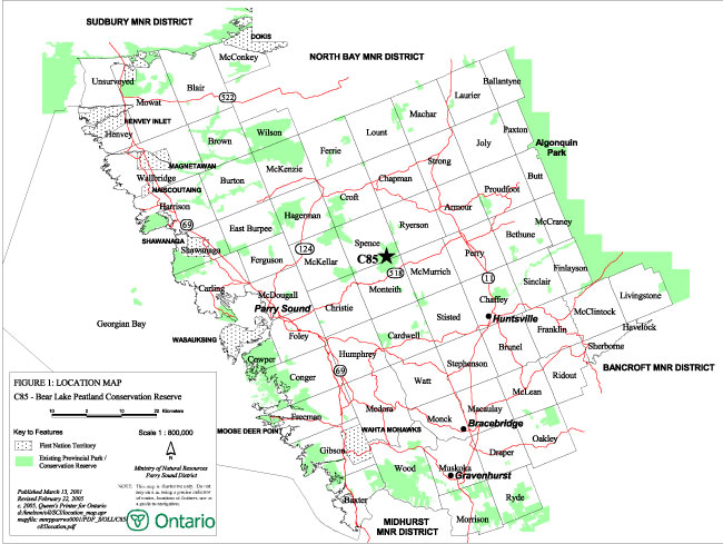
Enlarge Figure 1: Location Map
Figure 2: Site Map
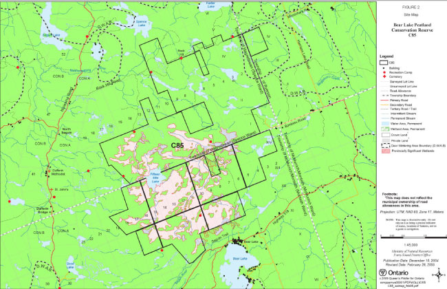
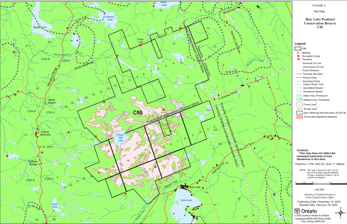
1.0 Introduction
Ontario’s Living Legacy, the result of an extensive planning process that began in early 1997, culminated in the approval in July 1999 of a Land Use Strategy that identifies the intended strategic direction for Crown land in central and northern Ontario, including the completion of Ontario’s system of parks and protected areas. This process, which included public consultation, resulted in the recommendation for regulation of 378 new protected areas, including Bear Lake Peatland Conservation Reserve (C85).
Bear Lake Peatland Conservation Reserve consists of 3,845 hectares of Crown land, located about a half kilometre north of the hamlet of Bear Lake, and about 8 kilometres west of the hamlet of Sprucedale, in the Territorial District of Parry Sound. It lies mainly within Monteith Ward of the Township of McMurrich/Monteith and Spence Ward of the Township of Magnetawan, with a small portion (2 lots) within the Township of Ryerson. The conservation reserve consists entirely of Crown lands. It abuts against private land for most of its boundary on the south, east and north sides. It adjoins Crown land along its western boundary in Monteith and Spence Townships. Three separate blocks of private land are bounded on all sides by the conservation reserve except for adjacent municipal road allowances. These lands are not part of the conservation reserve, and will remain privately owned.
A large portion of Bear Lake Peatland Conservation Reserve surrounding Fifteen Mile Lake was identified as a Candidate Area of Natural and Scientific Interest (ANSI) in 1993 for its likelihood of being a provincially significant peatland. The peatland is situated in a headwater area of the Manitouwabing and Seguin Rivers and contains extensive open fen, treed fen and conifer swamps. While the Candidate ANSI status no longer applies, this area was formally evaluated as a provincially significant wetland according to the Ontario Wetlands Evaluation System – Northern Manual in 1997. The site contains excellent habitat for moose, as well as a variety of other wildlife species including bear, white-tailed deer, waterfowl, reptiles, amphibians, small mammals and birds. A variety of provincially and locally significant plants are found in the provincially significant wetland portion of this conservation reserve.
Large game hunting is the major recreational activity that takes place within the conservation reserve. The majority of hunting activity in this site is focused on moose; white-tailed deer, small game and waterfowl hunting also occur within the site.
Conservation reserves are established under the authority of the Public Lands Act, Ontario Regulation 805/94. Bear Lake Peatland Conservation Reserve was established by Ontario Regulation 461/00 on August 10, 2000.
A Statement of Conservation Interest (Statement of Conservation Interest) is prepared under the direction of Procedural Guideline A – Resource Management Planning (PL. Procedure 3.03.05). The purpose of this Statement of Conservation Interest is to identify and describe the values of Bear Lake Peatland Conservation Reserve. The Statement of Conservation Interest also outlines the activities that currently occur within the conservation reserve and provides guidelines for the management of current and future activities in the context of protecting the natural, recreational and cultural values.
1.1 Background Information:
| Name | Bear Lake Peatland Conservation Reserve (C85) |
|---|---|
| Site Region/District | Georgian Bay Site Region, Site District 5E-8 |
| OMNR Administrative Region/District/Area | Southern Region/ Parry Sound District/ Parry Sound Area |
| Total Area (ha.) | 3,845 hectares |
| Regulation Date | August 10, 2000, by Ontario Regulation 461/00 |
| First Nations | Robinson-Huron Treaty and Williams Treaty |
| OBM map sheets | 10 17 6000 50300, 6000 50350, 6050 50300, 6050 50350, 6050 50400, 6100 50300, 6100 50350, 6100 50400 |
| Topographic Map | Orrville 31 E/5 Magnetawan 31 E/12 |
| UTM co-ordinates | 17T 60880 503920 (centroid) |
1.2 Representation
Earth science representation:
Bedrock
- Moon Island Gneiss association of the Parry Sound Domain, Parry Sound Terrain in the Central Gneiss Belt of the Proterozoic Grenville Province.
- intermediate orthogneiss and later pegmatites.
Surficial -
- shallow sandy tills on low-relief bedrock islands surrounded by extensive bog and peatland.
Life science representation:
The following landform types and vegetation associations are found in the conservation reserve (Rouse 2000):
- VIIa-7 - Weakly broken bare bedrock plain, much of it overlain by organic soils
- Ia-1 - Weakly broken shallow sandy till plain
A wide variety of wetland types are represented in the peatlands: extensive open fen, treed fen and conifer swamps, patterned treeless bogs, beaver ponds and marshes. Drier sites tend to deciduous and mixed forest types. There are a variety of significant plants and birds associated with this site (Deary, 1997).
Cultural Resources Representation:
Neither detailed cultural research nor inventory has been carried out for this conservation reserve. However, it is near the historic Nipissing Road (to the west) and the former Ottawa-Arnprior-Parry Sound Railway (to the south), and is crossed near its north boundary by the former Ryerson Junction Colonization Road, now known as the Rock Hill Road. The former hamlet of Rock Hill was partially in the northern part of the conservation reserve. The site is known to contain a cemetery and two possible grave sites, and may contain other historic locations or features. In addition, a major historic east/west First Nations travel corridor traversed this general area and may have crossed what is now conservation reserve (Allen, 1999).
Recent regional evaluation (OMNR, 2003) provides generalized broad-brush mapping which identifies several areas along waterways throughout this conservation reserve that have a high potential for cultural heritage sites.
Recreational Opportunities:
A recreational inventory report was prepared for this site based on numerous site visits, existing knowledge and data sources of MNR staff (Benvenuti, 2004). Recreationally, the conservation reserve is known to be used for sport hunting, recreation camp use, some all-terrain vehicle and snowmobile travel, and general outdoor exploring and it is considered to have potential for nature appreciation activities (Parent & Rouse, 2000).
1.3 Survey Work
| Survey Level | Earth Science | Life Science | Cultural | Recreational | Other |
|---|---|---|---|---|---|
| Reconnaissance | Frey & Duba, 2000 | Deary, 1997 Kamstra, 1995 Rouse, 2000 |
Allen, 1999 OMNR, 2003 Benvenuti, 2004 |
Benvenuti, 2004 Parent & Rouse, 2000 |
None |
| Detailed | None | None | None | None | Peat and peatland evaluation, Monenco 1984 |
| Requirement | None | Monitor the status/presence of significant species and associations. | Research to be encouraged | Monitor use impacts | None |
2.0 Values to be Protected
Bear Lake Peatland Conservation Reserve is located entirely within Hills (1959) ecological Site District 5E-8. It contains a provincially significant wetland, which includes the most extensive peatland and bog habitat in this site region. The wetland community is surrounded by ecologically representative upland forest types generally situated on bare bedrock with shallow soils. Values include earth science, life science, cultural and recreational/aesthetic values, with an emphasis on the life sciences.
2.1 Earth Science:
(Earth science information, unless otherwise noted, is taken from Frey & Duba, 2000)
Bedrock:
Earth science values are focused on features (bedrock and surficial) that represent the chronology of earth history in the province (Davidson, 1981).
The bedrock of Bear Lake Peatland Conservation Reserve is in the central east part of the Parry Sound Domain, Parry Sound Terrane of the Central Gneiss Belt, in the Proterozoic Grenville Province. The dominant rock types are dioritic to quartz dioritic orthogneisses and later pegmatites of the Moon Island gneiss association (Easton, 1992a, and 1992b).
The Parry Sound Terrane is one of four lithotectonic terranes of the Central Gneiss Belt. Within the Parry Sound Terrane, the Parry Sound Domain is one of three structural domains. This geological environment is part of the modern organization of the complex products of the mid-Proterozoic Grenville orogenic events (Easton 1992b).
The Parry Sound Domain is a block of 1400 to 1350 million-year-old mantle-derived rocks. The Parry Sound Domain consists of large volumes of mafic rocks of mainly plutonic protolith, anorthosite and marble, metamorphosed, almost uniformly, to granulite grade. These assemblages are unique in the Central Gneiss Belt. The eastern Parry Sound Domain is dominated by diorite and anorthosite in the western portion and older metasedimentary and metaplutonic gneisses in the eastern part of this segment. The dominant structural patterns of the Parry Sound Domain strike north-northeast, intersected by younger faults that strike east-northeast to west-northwest.
The Grenville Province is the product of thrusting and imbrication of the crust to the northwest as it collided with a continental landmass to the southeast. The Grenville Orogeny, circa 1140 to 1070 million years ago, culminated more than 500 million years of crustal evolution. The eroded roots of the products of these events are displayed in the complexly metamorphosed and deformed rocks of the region (Easton, 1992b).
From an earth science perspective, the geology of the conservation reserve is part of the modern organization of the complex products of the mid-Proterozoic orogenic events (Easton 1992a & b) and contributes to the conservation of the Grenville continental accretion theme (Davidson 1981). It has regional significance in its representation of intermediate orthogneiss and later pegmatites of the Moon Island gneiss association, typical of a large part of the eastern Parry Sound Domain (Frey & Duba, 2000).
Surficial:
Bear Lake Peatland Conservation Reserve is an extensive bog and peatland with a few small, scattered islands of very low relief bedrock outcrop with shallow sandy tills. These lowland areas are surrounded by bare bedrock and shallow soil uplands.
2.2 Life Science:
(Life science information, unless otherwise noted, is taken from Rouse, 2000)
The conservation reserve is located within Hills’ (1959) ecological Site District 5E-8. The assessment of life sciences is primarily focused on landform type and the vegetation communities that occur thereon within the context of a site district. The central and south-western portions of Bear Lake Peatland Conservation Reserve contain an extensive bog and peatland with a few small scattered islands of very low relief bedrock outcrop. The northeast portion of the conservation reserve and much of the area surrounding the wetlands are generally upland forest types situated on bare bedrock with shallow soils. The complex of wetlands associated with the peatlands was evaluated and determined to be provincially significant (Deary, 1997).
Representation:
Bear Lake Peatland Conservation Reserve is situated on one of the most extensive peatlands in ecological Site District 5E-8, and contains the greatest extent of unforested bog vegetation in the site district. Extensive areas of open graminoid bog with hummocks of shrub bog and thicket swamp vegetation is typical. On drier sites black spruce and larch forests are relatively well developed, leading to stunted early successional deciduous and mixed forest on dry knolls projecting through organic deposits (Brunton 1993). The upland forest types surrounding the wetland community are generally ecologically representative.
As a whole, the entire Bear Lake Peatland Conservation Reserve includes all four main wetland types: bog, fen, marsh and swamp. Within these categories marsh, conifer and shrub swamp, through a gradation of graminoid and treed fens to sphagnum bog, are present. There appear to be various stages of wetland evolution in different parts of the deposit, a dynamic feature that makes this deposit, due to its large size, unique in the area (Monenco 1984).
Condition:
There have been no recent forest harvesting or mining activities within Bear Lake Peatland Conservation Reserve. Rock Hill Road (formerly known as the Ryerson Junction Colonization Road) crosses east/west through the north end of the conservation reserve. Six Crown land recreation camps are located within its boundaries. There are known to be unauthorized recreational trails within the conservation reserve which receive use by snowmobiles and all-terrain vehicles, much of this use in association with fur harvesting, sport hunting and the recreation camps.
Sport hunting, fur harvesting, sport fishing and bait fish harvesting occur in the conservation reserve. These activities are not considered to have any significant impact on the quality of life science representation, although it is recognized that wetland vegetation and soils may be sensitive to compaction from pedestrian and recreational vehicle traffic.
Diversity:
Kamstra (1995) recorded 115 species of vascular plants, 23 species of birds, 9 species of mammals, 3 reptile species and 7 species of amphibians, over a three day period in late August 1994. Virtually all of the recorded plant species are native which indicates the high quality and undisturbed condition of the site (Kamstra, 1995).
Ecological considerations:
Bear Lake Peatland Conservation Reserve is the most extensive peatland and bog habitat in ecological Site District 5E-8. It consists of extensive open fen, treed fen and conifer swamps surrounding Fifteen Mile Lake and parts of this provincially significant wetland resemble the patterned treeless bogs of Ontario’s far north. Upland areas dominated by dry-mesic forest are scattered within and surrounding the peatland (Kamstra, 1995). A number of beaver ponds and marshes also occur in this area. There are a variety of significant plants and birds associated with this site, as well as excellent moose habitat.
Bear Lake Peatland Conservation Reserve is situated in a headwater area of the Manitouwabing and Seguin Rivers, both of which flow west (Kamstra, 1995).
Special Features:
Parts of the provincially significant wetland resemble the patterned treeless bogs of Ontario’s far north. Significant species noted in association with this conservation reserve are:
- Carey’s Knotweed – Polygonum careyi (Kamstra, 1995)
- Sandhill Crane – Grus canadensis, Nesting. (Kamstra, 1995)
- Osprey – Pandion haliaetus, Nesting.
- Great Blue Heron – Ardea herodius, Nesting within 100 metres of the conservation reserve boundary. Kamstra (1995) mentions unconfirmed reports of Southern Bog Lemming (Synaptomys cooperi) in the conservation reserve, and there is also an unconfirmed sighting of eastern Massasauga rattlesnake (Sistrurus catenatus catenatus) approximately 500 metres southwest of its boundary (Rouse, 2000).
Significance:
Bear Lake Peatland Conservation Reserve provides excellent representation of a large provincially significant peatland and bog complex in ecological Site District 5E-8, including areas of patterned treeless peatlands.
2.3 Cultural Values:
While no specific cultural studies or inventories have been undertaken within the conservation reserve, and no major cultural resource values have been evaluated or identified to date, recent regional evaluation (OMNR, 2003) provides generalized broad-brush mapping which shows that there are several areas identified along waterways throughout this conservation reserve that may have a high potential for cultural heritage sites.
Private research (Allen, 1999) has identified that the southern portion of the site may include part of a historic First Nations east-west travel corridor. It has also been reported to have been a part of a Chippewa hunting ground (Allen, 1999).
The Seguin Trail, originally the Ottawa-Arnprior-Parry Sound Railway (which was built by J. R. Booth in the 1890s) follows close to the southern boundary of this site. The Nipissing Road, an historic colonization/settlement road, passes just west of the site. The Rock Hill Road (formerly known as the Ryerson Junction Colonization Road) crosses east/west through the north of the site from the Nipissing Road. The settlement of Rock Hill was located within the northern portion of the conservation reserve in Concession 4, Spence Township. The old Rock Hill Pioneer Cemetery is located within the conservation reserve in Lot 7, Concession 4, Spence Township, and there are also reports of two separate grave sites elsewhere in the conservation reserve (Benvenuti, 2004). It is suspected that other cultural artifacts of the late 19th and early 20th centuries may also be present in the area.
2.4 Recreational/Aesthetic Values:
(Recreational information, unless otherwise noted, is taken from Benvenuti, 2004)
Large game hunting is the major recreational activity that takes place within the conservation reserve. The majority of hunting activity in this site is focused on moose, and to a lesser extent white-tailed deer in some of the northern portions. Waterfowl hunting is also popular within the boundaries of the conservation reserve.
Bear Lake Peatland Conservation Reserve is accessible from the north via the former Ryerson Junction Colonization Road, now known as the Rock Hill Road, which branches east off the Nipissing Road and runs through the northern portion of the site. Access from the Rock Hill Road is also possible from the east side of the conservation reserve via Harrison Lake Road. From the south, access can be gained via the Seguin Trail which runs adjacent to a portion of the site’s southern boundary located in Concession 11, Monteith Township. There are numerous recreational trails and unmarked trails branching off the Seguin Trail, Nipissing Road and the Rock Hill Road that are used by snowmobiles and all-terrain vehicles. Part of this use is for access to the six Crown land recreation camps that are authorized under land use permit within the conservation reserve. These trails are also used in conjunction with sport hunting and other outdoor activities, and likely also provide access to the three private land parcels bounded by the conservation reserve.
The Seguin Trail, which travels east/west immediately outside the southern boundary of Bear Lake Peatland Conservation Reserve is a major snowmobile trail in the winter (OFSC TOPS), and is also the route of the Trans-Canada Trail and the Park to Park Trail, both of which are multipurpose recreational trails.
In addition to current activities, the conservation reserve has potential for providing snowshoeing, bird watching and general nature activities (Parent and Rouse, 2000).
With the exception of the potential for wild fire and concern about compaction of wetland vegetation and soils, current levels of recreational use pose little threat to the other values of the conservation reserve. The wetland vegetation found in the site including that found in the provincially significant wetland, is the most sensitive feature. The impact of increased recreation use or resource development, such as recreational trail development, could pose a serious risk to sensitive vegetation and/or the connectivity of many of the site’s significant wetland habitats.
The distance of this conservation reserve from urban areas has resulted in a relatively pristine night sky, which enhances the sense of remoteness and wilderness of this site. Pristine night skies are considered a significant value, given the increasingly limited areas of southern and central Ontario that are not heavily affected by light pollution.
3.0 Management Guidelines
MNR’s Class Environmental Assessment for Provincial Parks and Conservation Reserves came into effect on January 10, 2005. All new MNR projects in conservation reserves, and any new approvals or permits issued, must meet the legal requirements of this Class Environmental Assessment, and any relevant amendments.
3.1 Land Tenure:
Background:
Bear Lake Peatland Conservation Reserve consists entirely of Crown land, located mainly within Monteith Ward of the Township of McMurrich/Monteith and Spence Ward of the Township of Magnetawan, with a small portion (2 lots) within the Township of Ryerson. The boundary of the conservation reserve abuts private land for most of its length on the south, east and north sides. It adjoins Crown land along its western boundary in Monteith and Spence townships. Three separate blocks of private land are bounded on all sides by the conservation reserve except for some adjacent municipal road allowances (Figure 2). These lands are not part of the conservation reserve.
Road allowances in the Spence Township portions are included as a part of the conservation reserve, except where they provide access to adjacent or surrounded private land; these road allowances were stopped up and closed prior to incorporation of Spence Township into the Township of Magnetawan. Road allowances within Monteith Township are owned by the municipality and are therefore not part of the conservation reserve.
There are six recreation camps authorized by Land Use Permit within the conservation reserve, 5 in Spence Township and 1 in Monteith Township. The conservation reserve falls within portions of the following three registered traplines: PS09N14601, PS09N08801 and PS08N17701. Two Bear Management Areas cover the conservation reserve. One (PS-49-007) covers the area within Monteith and Spence Townships. The second (PS-49-009), covers the small portion of the conservation reserve that lies in Ryerson Township. Bear Lake Peatland Conservation Reserve overlaps several commercial Bait Fish Blocks, namely PS-109, PS-114, PS-138, and PS-139.
Guideline:
The sale of Crown lands is generally not permitted in conservation reserves. Exceptions will only be considered under unusual circumstances, such as where an adjacent privately owned parcel has inadequate area for the installation of a septic system. These circumstances are not likely to apply in this conservation reserve.
Consideration may be given in the future to acquisition of significant lands within the provincially significant wetland, where a property is offered for sale.
Existing recreation camps are permitted to continue. They may be eligible for enhanced tenure, but not the purchase of land (see Appendix 4). Where authorized in writing, the Ministry of Natural Resources would consider permitting transfer of, or alterations to authorized recreation camps, as long as there are no negative impacts on the values of the conservation reserve.
New recreation camps are not permitted in conservation reserves.
Registered traplines will continue to be authorized within the conservation reserve. New trapline cabins, however, are not permitted.
Provision of commercial bear hunting services is allowed to continue within the conservation reserve.
Bait Fish Blocks surrounding and including portions of the conservation reserve are permitted to continue.
3.2 Development:
Background:
Buildings associated with six recreation camps are located within Bear Lake Peatland Conservation Reserve, but no other buildings are known of at this time. A graveyard (Rock Hill Cemetery) is located in the north portion of the conservation reserve. Tertiary roads, known multipurpose recreational trails and unauthorized trails provide access to and within the conservation reserve, and are used for recreational travel by snowmobile and all-terrain vehicles. There are several structures located within the site such as floating rafts, corduroy roads and home-made bridges to facilitate all-terrain vehicle travel over low lying wetland areas. There are also trapline trails used in conjunction with the registered trapline areas.
The Seguin Trail, a year round multi-use recreational trail (Trans-Ontario Provincial Snowmobile trail, Trans-Canada Trail, Park-to-Park Trail) lies immediately south of the south boundary the conservation reserve, but is not included within it. That trail has the potential of bringing a variety of recreational trail uses to the edge of the site.
The Rock Hill Road, formerly known as the Ryerson Junction Colonization Road, which crosses the north end of the conservation reserve, is no longer suitable for passenger vehicle traffic. It was recently a groomed Ontario Federation of Snowmobile Clubs (OFSC) Trans-Ontario Provincial Snowmobile (TOPS) trail but is no longer maintained as such.
Guideline:
New private access or resource access roads, and additions to or upgrading of existing roads are not permitted. There is no intention to develop or improve roads outside of the conservation reserve to improve access to this site.
New recreational trails may be considered on a case by case basis, as is discussed in more detail in Section 3.3 "Recreational Activities". New recreational trails for motorized vehicles are discouraged and will only be considered under exceptional circumstances if the criteria identified in Section 3.3 have been demonstrated.
Unauthorized works within the conservation reserve will be handled in accordance with the Public Lands Act, and any required removal of these works will be at the expense of those responsible.
No mineral exploration is permitted within this conservation reserve. This policy direction is based on a commitment made by the Ministry of Natural Resources and the Ministry of Northern Development and Mines in March 2002. This direction replaces that identified in the 1999 Ontario’s Living Legacy Land Use Strategy (OMNR, 1999), which stated that controlled mineral exploration would be permitted in new conservation reserves which were identified as having provincially significant mineral potential.
Any new development must meet MNR’s commitments to protect cultural heritage values (see Section 3.7).
While there is no intent at present to provide or permit any new development in this conservation reserve that would require lighting, should this be considered at some point in the future the MNR will not allow unnecessary, undirected light pollution. This commitment recognizes the wilderness and biological values provided by a pristine night sky.
3.3 Recreational Activities:
Background:
Existing known recreational activities include sport hunting, recreation camp use, general exploring and snowmobile and all-terrain vehicle use.
Guideline:
Hunting is permitted to continue within the conservation reserve.
No off-trail use of snowmobiles or all-terrain vehicles is allowed in conservation reserves.
Recreational uses such as wildlife viewing, snowshoeing, and cross-country skiing, while currently very limited in extent and therefore not managed, are allowed to occur in the conservation reserve.
The use of pre-existing recreational trails (trails that existed at the time of regulation of this conservation reserve), and any increase in use of snowmobiles or all-terrain vehicles will be monitored to ensure that conservation reserve values are not being adversely impacted. Depending on the results of monitoring, pre-existing trails may need to be redirected from sensitive areas or eliminated completely. There is no intent to mark or upgrade these trails.
New recreational trails may be considered on a case by case basis provided that they meet Procedural Guideline B – Land Uses – Test of Compatibility (see Appendix 1) and the MNR's Environmental Assessment Act requirements. Public consultation will generally be required during the consideration of changes to existing trails, and will always be required for new trails. New recreational trails will not be permitted in or within 120 metres of the provincially significant wetland unless it has been demonstrated that there will be no negative impacts on the natural features or the ecological functions of the wetland. Any new trails must meet MNR’s commitments to protect cultural heritage values (see Section 3.7).
New recreational trails for motorized vehicles will not be permitted within the boundaries of the provincially significant wetland. In areas outside the provincially significant wetland, new trails or upgrading of existing trails for motorized vehicle use, are discouraged and will only be considered under exceptional circumstances if the following have been demonstrated:
- there is a community need for the trail, as well as community support;
- there are no alternative suitable locations outside the conservation reserve;
- the trail location would be acceptable and suitable for four-season use;
- the trail would meet the requirements applicable to all trails, as identified in the preceding paragraph.
New recreational activities will be considered on a case by case basis provided they are consistent with maintaining the values of the conservation reserve and comply with Procedural Guideline B – Land Uses – Test of Compatibility (Appendix 1). Emphasis will be placed on activities that have a low impact on the environment of the conservation reserve.
Monitoring of existing and permitted activities will be undertaken as required to ensure that the conservation reserve values are not being adversely impacted.
3.4 Commercial Activities:
Background:
Current commercial use of the conservation reserve includes trapping (PS-88, PS-146 and PS-177), and the provision of bear hunting services (Bear Management Areas PS-49-007 and PS-49-009). The conservation reserve is included within four Bait Fish Blocks.
Forest management activities have not occurred recently, and the area has generally low values for forest products. There is no current mining activity within the site, which lies in an area of moderate mineral potential (OMNR 1983). The peatlands were investigated for their commercial peat value in the early 1980’s, and are considered to have the best potential for fuel peat development in the Parry Sound District (Monenco 1983).
Guideline:
Trapping will continue within the conservation reserve. However, new trapline cabins are not permitted within conservation reserves.
Provision of commercial bear hunting services is allowed to continue within the conservation reserve.
Bait fish harvesting operations will continue to be permitted within the conservation reserve.
While commercial timber harvesting is not allowed within conservation reserves, there are limited situations in which abutting landowners can harvest firewood for use on their adjacent property. Specifically, property owners and those with Crown land tenure who have no road access to their properties can apply for permits to cut limited amounts of firewood in the conservation reserve for their own use. This situation would apply only to authorized recreation camps within the conservation reserve.
Conservation reserves do not permit mineral exploration, mining, commercial forest harvesting, hydroelectric power development, the extraction of aggregate, peat, soils, or other industrial uses. (Public Lands Act, Ontario Regulation 805/94). Other new commercial activities must meet the requirements of Procedural Guideline B – Test of Compatibility (see Appendix 1).
3.5 Aboriginal Interests:
Background:
This site is known to be of interest to First Nation communities. There are 2 treaties associated with the area: the Robinson – Huron Treaty of 1850 and the Williams Treaty, (although a Supreme Court decision in 1994 (Howard) validated that the Williams Treaty surrendered hunting, fishing and trapping rights of those First Nations affiliated with that treaty).
Guideline:
The regulation and management of this conservation reserve will not impede the exercise of existing aboriginal or treaty rights. These rights include hunting, fishing, fur harvesting, gathering of plants for a variety of purposes, and the use of ceremonial sites. It is recognized that the manner in which these rights are carried out is not limited to the manner in which they were carried out in the past, but has evolved over time with changes in technology.
The designation of this area as a conservation reserve or the preparation of this Statement of Conservation Interest will not affect any future First Nation land claim settlement. The conservation reserve designation does not preclude consideration of these lands in the settlement of a claim. If deregulation of part or all of a conservation reserve occurs as part of the settlement of a claim, this will be carried out at no cost to First Nations.
3.6 Natural Resource Stewardship:
Background:
Bear Lake Peatland Conservation Reserve includes extensive peatland and bog habitat and contains a provincially significant wetland within its boundaries. The extensive wetland habitat in the conservation reserve contains excellent habitat for moose in addition to habitat for a variety of other wildlife species including bear, white-tailed deer, waterfowl, reptiles, amphibians, small mammals and birds. The site supports nesting sites for ospreys, and great blue herons are known to nest near the site. Adult and juvenile sand hill cranes have also been observed in the conservation reserve during the breeding and rearing seasons.
A number of small deer wintering areas lie within or near the boundaries in the north and east of this conservation reserve.
Vegetation management for specific purposes is not known to have occurred in the past and logging activity has been minimal. Wildlife management and fisheries management have been occurring according to the prevailing policies and legislation.
Guideline – General
The emphasis will be on ensuring that the natural values of the conservation reserve are not negatively affected by current and future activities. Therefore, applications for new specific uses will be carefully studied and reviewed. Necessary studies may be undertaken by proponents, the Ministry, and/or partner organizations.
Guideline – Vegetation:
The Ministry will continue to monitor for the status/presence of significant species and associations. Because of the known sensitivity of wetland communities to damage through compaction of vegetation and soils, the Ministry will monitor the impacts of activities within the conservation reserve.
In accordance with existing conservation reserve policy and the Fire Management Strategy for Ontario, forest fire protection will endeavour to use "light on the land" techniques, which do not unduly disturb the landscape, in this conservation reserve. Examples of light on the land techniques may include limiting the use of heavy equipment, and limiting the number of trees felled during fire response efforts. Input from the local MNR Area Supervisor would be solicited if a forest fire threatens the area. Opportunities for prescribed burning to achieve resource management objectives may be considered. Plans for any prescribed burning will be developed in accordance with the OMNR Prescribed Burn Planning Manual.
Programs may be developed to control forest insects and diseases in the conservation reserve where these threaten significant values in or adjacent to the site. Where insects or disease threaten significant values, in or adjacent to the site, and MNR determines that control is warranted, control within the conservation reserve will be directed by the MNR as narrowly as possible to the specific insect or disease. Biological control will be used wherever possible. In all cases, regard shall be had for Procedural Guideline B – Land Uses – Test of Compatibility (Appendix 1).
Guideline – Wildlife and Fisheries:
The relevant Ontario hunting and fishing regulations will guide these activities within Bear Lake Peatland Conservation Reserve. Fur harvesting and bait fish harvesting will be managed through the maintenance of the current licencing system.
The Ministry will monitor the impacts of trail use and other recreation activities on the natural values of the conservation reserve.
The management of game and fur species in Bear Lake Peatland Conservation Reserve will continue consistent with the wildlife management unit (WMU-49), trapline areas (PS09N14601, PS09N08801 and PS08N17701), and Bear Management Areas (PS-49-007 and PS-49-009) within which it lies.
The presence of juvenile and adult Sandhill Crane (Grus canadensis) and nesting Osprey (Pandion haliaetus) have been confirmed in the conservation reserve. The presence of Southern Bog Lemming (Synaptomys cooperi) is suspected. Great Blue Heron (Ardea herodius) are known to nest close to the conservation reserve boundary. The ministry will monitor the impacts of activities on these species. Management activities and proposals for new activities will have regard for the protection of these species and their habitat.
The Eastern Massasauga Rattlesnake, a threatened species (COSEWIC -- Threatened, COSSARO, OMNR – Threatened), is believed to have been seen about 500 metres south west of the conservation reserve. Occasional monitoring of the conservation reserve will include field checking for the presence of this species.
3.7 Cultural Resource Stewardship:
Background:
While no formal cultural studies or inventories have been undertaken within the conservation reserve, recent regional evaluation (OMNR, 2003) provides generalized broad-brush mapping which identifies several areas along waterways throughout this conservation reserve that have a high potential for cultural heritage sites. Private research (Allen 1999) has identified that the southern portion of the site may include part of a historic First Nations east-west travel corridor. It has also been reported to have been a part of a Chippewa hunting ground (Allen 1999).
The conservation reserve lies close to historic travel corridors (Nipissing Road, Ottawa-Arnprior-Parry Sound Railway), and Rock Hill Road (formerly known as the Ryerson Junction Colonization Road) crosses east/west through the north of the site. Areas within the conservation reserve, mostly along the Rock Hill Road, show evidence of a pioneer settlement, a cemetery, and other settlement/homesteading evidence. There are also reports of two separate grave sites elsewhere. It is suspected that other cultural artifacts of the late 19th and early 20th centuries may also be present in the area.
Guideline:
Should the MNR consider either carrying out or permitting new structural development, significant clearing of vegetation or altering of land within this conservation reserve, the MNR will adhere to the cultural heritage resource screening process as is identified in its Memorandum of Understanding (MOU) with the Ministry of Culture. While the purpose of this MOU is to provide a process to identify and protect cultural heritage resources when the MNR is reviewing work permits or disposing of Crown rights under the authority of the Public Lands Act, the considerations and criteria would also enable the MNR to identify high potential cultural heritage areas for other purposes within conservation reserves. If the screening process indicates that the site of a proposed activity is within an area of high cultural heritage potential, the MNR will consult with the Ministry of Culture to determine the appropriate cultural heritage assessment requirements and will undertake a preliminary archaeological assessment if appropriate.
The Ministry of Natural Resources will discuss the management and protection of the cemetery and the two other reported grave sites with the Ministry of Culture.
Interested partners will be encouraged to undertake inventories, studies, and research to document the histories of First Nations, settlement, resource harvest/management and recreation in the area. The MNR will discuss the appropriateness of any proposed archaeological assessment with local First Nations and the Ministry of Culture.
Under the Ontario Heritage Act, a licence is required to carry out any archaeological fieldwork. This includes altering or removing any artefact or any other physical evidence of past human activity.
3.8 Client Services:
Background:
Access to the conservation reserve has generally been confined to traditional uses for the current commercial and recreational activities, although the adjacent Seguin Trail has regional significance, and attracts members of the public from a wider area to the edge of the conservation reserve. There are no other Crown facilities or services developed on or adjacent to the conservation reserve. The information fact sheet for this conservation reserve is currently available to the public through the Parry Sound District Office or via MNR’s Internet site, http://www.mnr.gov.on.ca. Information about the values of this conservation reserve is available at the Parry Sound District Office.
Guideline:
The focus will remain on low key information and self-interpretation of conservation reserve values and features. Consideration will be given to the strategic location of identity signs where the Seguin Trail lies immediately south of the conservation reserve’s south boundary, and where tertiary roads and known trails approach or cross the conservation reserve boundary. Consideration will be given to the preparation of an information brochure (with map) to highlight the features for which this area was identified and appropriate uses to ensure the protection of those features.
3.9 Research:
Background:
Research to date has consisted of reconnaissance surveys and checklists of the earth science, life science and recreation values, and some more detailed life science surveys of the conservation reserve.
Guideline:
The Ministry will encourage further inventory and documentation of natural and cultural values, and the assessment of use/activity impacts on the conservation reserve. The Ministry will consider undertaking assessment of cultural values, including aboriginal values. MNR will discuss the appropriateness of archaeological assessment of aboriginal values with the local First Nations and the Ministry of Culture. Any research proposals/activities must follow Procedural Guideline C – Research Activities in Conservation Reserves (PL. Procedure 3.03.05) (Appendix 3).
3.10 Marketing:
Background:
There has been no direct marketing of Bear Lake Peatland Conservation Reserve to date. Promotion and information about this site has been primarily through the Ontario’s Living Legacy planning process, and Parry Sound District public consultation regarding the boundaries of this site.
Guideline:
Site specific marketing efforts will be kept to a minimum and any effort would be looked on in conjunction with the marketing of other conservation reserves in the District. The future will see continued use of fact sheets to inform the public about the role of the conservation reserve in a provincial system, and about its specific values.
4.0 Implementation
Administrative responsibility for Bear Lake Peatland Conservation Reserve lies with the Parry Sound Area Office of the Parry Sound District of the Ministry of Natural Resources. The Area Office will continue with the custodial care of the conservation reserve and will also seek partnerships with local interests, wherever appropriate. Implementation of this Statement of Conservation Interest will primarily involve monitoring activities to ensure adherence to the management guidelines.
Priorities will include:
- Ensure compliance to prescribed management direction of the approved Statement of Conservation Interest;
- Ensure compliance with applicable legislation and regulations;
- Monitor and evaluate existing and allowed recreational and commercial use levels and impacts as required to ensure that conservation reserve values are not being adversely impacted. In particular, existing unauthorized trails within the conservation reserve should be confirmed and accurately located, and their use monitored to ensure that their location, use, and the existence of trail structures (bridges, corduroy sections and wetland/water crossings) are not adversely affecting conservation reserve values;
- Actively seek partnerships with interested stakeholders;
- Encourage further inventory and research on the significant life science resources of the conservation reserve;
- Cultural/historic studies will be encouraged to identify, and determine the importance of any archaeological or historic values associated with the site;
- Discuss the management of the cemetery and two other reported grave sites with the Ministry of Culture;
- Encourage research about impacts of snowmobiles and all-terrain vehicles on significant flora and fauna species and communities of the site; and
- Provide client services (e.g. brochure or fact sheet) at nearby MNR offices.
5.0 Review and Revision of the Statement of Conservation Interest
This Statement of Conservation Interest will be amended through a standard process of minor and major amendments. Minor amendments will be processed in a relatively informal manner and will require the approval of the Area Supervisor; these minor amendments will deal with uses and activities that do not affect any of the policies in this Statement of Conservation Interest (e.g. new uses and/or activities that are consistent with existing permitted uses).
Uses and/or activities that were not anticipated in the approved Statement of Conservation Interest and which may have an impact on the values of the conservation reserve will require a major amendment. This will include an opportunity for public comment and input, and will require the approval of the District Manager and Regional Director.
6.0 References
Allen, Bill 1999. Email to Dorothy Shaver (MNR District Planner, Parry Sound), dated December 17, 1999, regarding possible First Nations travel routes.
Benvenuti, J. 2004. Recreation Resource Inventory Report. Bear Lake Peatland Conservation Reserve (C85)
Brunton D. F. 1993. Life Science Areas of Natural and Scientific Interest in Site District 5E-8: A Review and Assessment of Significant Natural Areas in Site District 5E-8. Algonquin Region, Ontario Ministry of Natural Resources.
Crins, W. J. and Kor, P. S. G. 1998. Natural Heritage Gap Analysis Methodologies Used by the Ontario Ministry of Natural Resources. Unpublished Paper. Peterborough: OMNR.
Davidson, R. J. 1981. A Framework for the Conservation of Ontario’s Earth Science Features. Toronto: Division of Parks, OMNR.
Deary Environmental Consultants. 1997. Bear Lake Wetland Evaluation, District of Parry Sound, Spence and Monteith Townships.
Easton R. M. 1992a. The Grenville Province and the Proterozoic history of central and southern Ontario; in Geology of Ontario, Ontario Geological Survey, Special Volume 4, Part 2.
1992b Tectonic evolution of Ontario. Part 3: Mesoproterozoic evolution of the southeast margin of Laurentia; in Geology of Ontario, Ontario Geological Survey, Special Volume 4, Part 2.
Frey E. & Duba D. 2000. Earth Sciences Checksheet, Bear Lake Peatland Conservation Reserve.
Hills, G. A. 1959. A ready reference to the description of the land of Ontario and its productivity. Ont. Dept. of Lands and Forests, Division of Research, Maple, Ontario.
Kamstra J. 1995. Botanical Survey of Bear Lake Peatland. Gartner Lee Limited.
Monenco Ontario Ltd. 1984. Ontario Geological Survey, Open File Report 5488, Peat and Peatland Evaluation of the Parry Sound Area Volume II
Ontario Ministry of Natural Resources (OMNR). 1993. Ontario Wetland Evaluation System: Northern Manual.
1999. Ontario’s Living Legacy: Land Use Strategy. Queen’s Printer for Ontario.
2003. Cultural Heritage Registered Site Reserves and Areas of High Potential, Parry Sound District, Scale 1:150,000.
Parent C. & Rouse J. D. 2000. Recreation Inventory Checklist. Bear Lake Peatland Conservation Reserve.
Rouse J. D. 2000. Life Sciences Checksheet. C85 Bear Lake Peatland Conservation Reserve.
Appendices
Appendix 1 Procedural Guideline B – Land Uses – Test of Compatibility (PL Procedure 3.03.05)
The conservation reserve policy provides broad direction with regard to the permitted uses. The policy provides only an indication of the variety of uses that will be considered acceptable in conservation reserves. The only caution is that "any new uses, and commercial activities associated with them, will be considered on a case by case basis, and, they must pass a test of compatibility to be acceptable." What does a ‘test of compatibility’ mean?
An examination of this must start from the premise of why an area is set aside – specifically, its representative natural heritage values. Criteria are then identified to guide compatibility considerations. These criteria apply to the long-term acceptability of both existing uses and new uses.
1. Conformity to Statement of Conservation Interest/RMP: Statements of Conservation Interest describe values for which an area has been set aside and the range of appropriate uses that will be permitted in the area. Statement of Conservation Interest may also speak to the acceptability of other ‘new’ uses currently not occurring in the area.
The first ‘test’ is: "do proposed new land uses and/or commercial activities conform to the direction of the Statement of Conservation Interest/RMP for the conservation reserve? Would the new use(s) depart from the spirit of appropriate indicator land uses in the Statement of Conservation Interest/RMP?"
2. Impact Assessment: If the proposed use(s) pass test 1 it is important to determine their impact on the area before they are approved. This should include the following:
- Impact on natural heritage values: "will the new use(s) impact any natural values in the area? If so how and to what degree? Is it tolerable?"
- Impact on cultural values: "will the new use(s) impact an historical or archaeological values in the area?"
- Impact on research activities: "will the new use(s) affect research activities in the area?"
- Impact on current uses: "will the new use(s) have any negative impact on the array of current uses?"
- Impact on area administration: "will the new use(s) increase administrative costs and/or complexity?" (For example, the cost of area monitoring, security and enforcement).
- Impact on accommodating the use outside the conservation reserve: "Could the use(s) be accommodated as well or better outside the conservation reserve?"
- Impact on socio-economics of the area: "will the new use(s) affect the community(ies) surrounding the area in a positive or negative way?" (For example, will the new use make an area less remote thereby affecting a local tourism industry that is dependent on the area’s remoteness for its appeal?"
- Impact on area accessibility: "does the new use(s) give someone exclusive rights to the area or a portion of the area to the exclusion of other existing uses?"
The following table (Appendix 2) provides a guide of indicator uses for the consideration of uses that may be permitted within conservation reserves. For any specific conservation reserve that test of compatibility should be applied to determine which specific uses are acceptable.
Appendix 2 Indicator Uses for Conservation Reserves: Generic and Specific
Recreation
| Activities | Generic Policy | Specific Application in Bear Lake Peatland Conservation Reserve C85 | |
|---|---|---|---|
| Existing | New | ||
| Sport fishing | Yes | Yes | Yes |
| Sport hunting | Yes | Yes | Yes |
| Food gathering | Yes | Yes | YesA |
| Facility infrastructure | Maybe | Maybe | Maybe |
| Off-trail snowmobiling | No1 | No1 | No1 |
| Off-trail all-terrain vehicle use | No1 | No1 | No1 |
| Rock climbing/caving | Maybe | Maybe | N/A |
| Canoeing/kayaking | Yes | Yes | Yes |
| Motorized boating | Yes | Yes | Yes |
| Picnicking | Yes | Yes | Yes |
| Camping | Maybe | Maybe | Yes |
| Trails: Hiking | Yes | Maybe | MaybeB |
| X country skiing | Yes | Maybe | MaybeB |
| Cycling | Yes | Maybe | MaybeB |
| Horse riding | Yes | Maybe | MaybeB |
| Snowmobiling | Yes | Maybe | MaybeB |
| All-Terrain Vehicles | Yes | Maybe | MaybeB |
Science, Education & Heritage Appreciation
| Activities | Generic Policy | Specific Application in Bear Lake Peatland Conservation Reserve C85 | |
|---|---|---|---|
| Existing | New | ||
| Research | Yes | Yes | Yes |
| General walking | Yes | Yes | Yes |
| Photography & Painting | Yes | Yes | Yes |
| Wildlife viewing | Yes | Yes | Yes |
| Outdoor Education/Interpretation | Yes | Yes | Yes |
| Collecting | No | No2 | No2 |
Commercial Activities
| Activities | Generic Policy | Specific Application in Bear Lake Peatland Conservation Reserve C85 | |
|---|---|---|---|
| Existing | New | ||
| Food harvesting | Maybe | Maybe | No |
| Fishing | Maybe | Maybe | No |
| Bait Fish harvesting | Yes | Maybe | Yes3 |
| Fur harvesting | Yes | Maybe | Yes3 |
| Trap cabins | Yes | No | No |
| Resort – outpost camp | Yes | No | No |
| Outfitting – bear management | Yes | No | Yes3 |
| Wild rice harvesting | Yes | Maybe | N/A |
Resource Management
| Activities | Generic Policy | Specific Application in Bear Lake Peatland Conservation Reserve C85 | |
|---|---|---|---|
| Existing | New | ||
| Inventory monitoring | Yes | Yes | Yes |
| Featured species management | Maybe | M | M |
| Natural systems management | Maybe | Maybe | Maybe |
| Insect and disease control | Maybe | Maybe | Maybe |
Industrial Activities
| Activities | Generic Policy | Specific Application in Bear Lake Peatland Conservation Reserve C85 | |
|---|---|---|---|
| Existing | New | ||
| Timber harvesting | No | No | No |
| Mineral exploration | No | No | No |
| Mining | No | No | No |
| Hydro generation | No | No | No |
| Energy transmission corridors | Yes | No4 | No4 |
| Communications corridors | Yes | No4 | No4 |
| Public transportation corridors | Yes | No4 | No4 |
| Resource access roads | Maybe | No | No |
| Private access roads | Maybe | No5 | No |
Other Activities
| Activities | Generic Policy | Specific Application in Bear Lake Peatland Conservation Reserve C85 | |
|---|---|---|---|
| Existing | New | ||
| Land Disposition | Maybe6 | Maybe6 | Maybe6 |
| Recreation Camps | YesC | No | YesC |
Appendix 3 Procedural Guideline C: Research Activities in Conservation Reserves (PL Procedure 3.03.05)
Purpose
To encourage contributions to the goal of conservation reserves by:
- Providing direction for research activities associated with conservation reserves; and
- Establishing a process for the review and approval of proposals by researchers which could have an impact on the values protected by the conservation reserve.
Definition
Research means any investigation or study of the natural, cultural, economic, management or other features or characteristics of conservation reserves.
Guidelines
Research will be encouraged to provide a better understanding of the natural values protected by a conservation reserve and to advance their protection, planning and management. The Statement of Conservation Interest will define, for each conservation reserve, the key research issues, set out the parameters within which research may occur and identify research needs.
Applications and Approvals
Researchers must apply in writing to the relevant Area Supervisor(s) for permission to conduct research. The request letter must contain a statement explaining why the proposed research should be undertaken in the particular conservation reserve in preference to another location.
Proposals will be reviewed and approved by the relevant Area Supervisor(s), guided by the Statement of Conservation Interest prepared for each reserve (see Guideline A – Resource Management Planning) and using Guideline B – Land Uses – Test of Compatibility. Permission must be granted in writing, including any conditions to be met in conducting the research, prior to the undertaking of any research project.
Term and Conditions
Permission to conduct research under this policy will be valid for a period of 12 consecutive months from the date of issue. Permission to continue a research project for an additional period of 12 months or less may be granted upon submission of a written request and a progress report. The Ministry may require the posting of collateral to assure that the terms and conditions of granting permission are met.
The Area Supervisors may suspend or revoke permission at any time for failure on the part of the researcher to meet:
- The intent of this policy.
- The requirements under the Public Lands Act, Ontario Regulation 805/94 including all amendments, where applicable.
- The requirements under any other Act or regulations of Ontario or Canada, including those governing the taking, handling, storing, confining, fur harvesting, excavating and marketing any specimen, artefact, information or action (for example, scientific collector’s permit).
- The conditions and agreements specified in granting permission.
Final Report
The researcher will submit copies of reports, publications and theses following the results of the project to the relevant Area Supervisor(s).
Appendix 4 Recreation Camp Tenure
Existing recreation camps within conservation reserves are generally permitted to continue. They may be eligible for "enhanced" tenure, but are not eligible for purchase of land. There are 2 forms of enhanced tenure that may be considered (as per September 22, 2000 direction from MNR’s Assistant Deputy Ministers of Natural Resource Management and of Field Services):
- upgrade in the nature or type of tenure (e.g. from a Land Use Permit to a lease); and/ or
- an extension in the term of the tenure (e.g. from 1 year to 10 years).
Applications for enhanced tenure will be approved if determined acceptable using these screening criteria:
- Must follow the review process identified in MNR’s land disposition policies:
- MNR District Manager must ensure that there will be no serious, foreseeable resource management or user conflicts as a result of the enhanced tenure;
- The intended use/activity will not likely have a negative impact on the values identified in the Provincial Policy Statement, issued under Section 3 of the Planning Act;
- The site conforms with the MNR’s land use planning direction;
- The disposition is reviewed under the MNR’s Class Environmental Assessment for Provincial Parks and Conservation Reserves;
- The site is not within a Provincial Significant Wetland (PSW). If the site is adjacent to a PSW it must be determined that the proposed enhancement of tenure will not have a negative impact on the function or natural features of the wetland;
- If the site is on lake trout lake, a lease will only be considered after such time as the policy on development on such lakes has been approved;
- Would not result in increased negative impact on natural heritage, cultural heritage or recreational values of the conservation reserve, or on existing authorized land uses;
- Must be subject to consultation with affected First Nations, and be consistent with any aboriginal land claim negotiations or protocol agreements;
- All rents, taxes, fees, rates or charges must be paid up.
A change in tenure does not convey a commitment to provide for, or agree to, a change in the type or the standard of existing access to the recreation camp.
Notes:
On generic policy application in conservation reserves:
1For direct retrieval of game only.
2Only as a part of an approved research project.
3Transfer requests will be considered in the context of the Statement of Conservation Interest or Resource Management Plan for each conservation reserve.
4Existing use is permitted to continue. New transportation corridors, communications lines, and transmission lines are discouraged in conservation reserves except under unusual circumstances where there are no other viable alternatives.
5New private roads, including additions to existing roads, will not be permitted except where there are existing commitments.
5Sale of Crown lands in conservation reserves is not permitted, except for certain minor dispositions (e.g. sale of small parcel of land where adjacent private lot is too small to enable installation of a septic system, or to facilitate legal title to lands where there has been a long-standing encroachment of a dwelling on Crown land) where they do not detrimentally affect the values an area is intended to protect.
On specific policy application in Bear Lake Peatland Conservation Reserve:
AFood gathering is permitted for personal consumption only and must be conducted in a sustainable manner, and such that it does not harm the values of the conservation reserve.
BExisting authorized recreational trails are permitted to continue in conservation reserves as long as there are no significant environmental impacts and they do not impair the natural features and values for which the area is identified. New recreational trails may be considered on a case by case basis, provided that they meet the requirements identified in Section 3.3 of this document. New recreational trails for motorized vehicles will not be permitted within the boundaries of the provincially significant wetland. Outside the boundaries of the provincially significant wetland, new recreational trails for motorized vehicles are discouraged and will only be considered under exceptional circumstances if the criteria identified in Section 3.3 have been demonstrated.
CExisting authorized recreation camps within conservation reserves are generally permitted to continue. They may be eligible for "enhanced" tenure, but are not eligible for purchase of land (See Appendix 4). New recreation camps are not permitted.