Black Bay Bog Conservation Reserve Management Statement
This document provides policy direction for the protection, development and management of the Black Bay Bog Conservation Reserve and its resources.
Black Bay Bog Conservation Reserve (C2243)
Statement of Conservation Interest
November 2001
Prepared for the Ontario Ministry of Natural Resources
Nipigon District
by Rebecca Zeran
OLL Resource Manager
Approval page
Statement of Conservation Interest for Black Bay Bog Conservation Reserve C2243
Nipigon District
Northwest Region
The purpose of this Statement of Conservation Interest is to identify the natural heritage values of the Conservation Reserve and to identify the activities which occur at this location. This Statement outlines the activities which will be permitted and those which will be prohibited. From this outline, the management direction for the site can be determined.
Approved:
Ian Hagman
District Manager
Nipigon District
Date: February 11, 2002
Ralph Wheeler
Acting Regional Director
Northwest Region
Date: May 17, 2002
1. Introduction
On July 16, 1999, the Ontario Government released Ontario’s Living Legacy (OLL) Land Use Strategy (LUS) to guide the planning and management of Crown Lands within a large part of northern and central Ontario. A major component of this Land Use Strategy was the establishment of 378 new protected areas in this part of Ontario. This commitment will be the largest expansion of Provincial Parks and other protected areas in the history of Ontario.
The Black Bay Bog Conservation Reserve (C2243) is one site within this expansion of Ontario’s protected areas.
Conservation reserves are areas of Crown land set aside by regulation under the Provincial Parks and Conservation Reserves Act, 2006 to complement provincial parks in protecting representative natural areas and specific landscape features. Most recreational activities (e.g. hiking, skiing, tourism related uses, nature appreciation) and non-industrial commercial activities (e.g. fur harvesting, bait fishing and commercial fishing) that have traditionally been enjoyed in the area will continue – provided that these uses do not impact upon the natural features requiring protection. Recreational hunting and fishing are permitted uses within all new conservation reserves identified through the OLL Land Use Strategy. Commercial timber harvesting, mining, aggregate extraction and hydroelectric development are prohibited in conservation reserves.
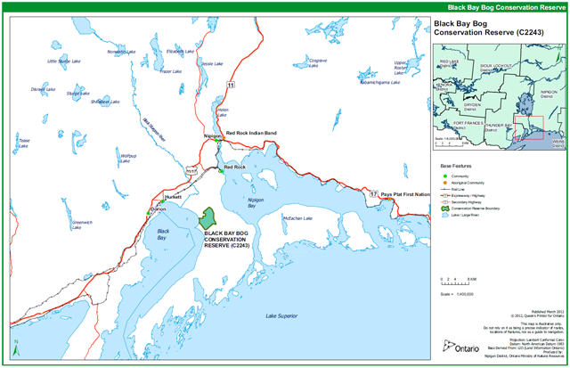
The Black Bay Bog Conservation Reserve is situated at the north end of the Black Bay Peninsula and is approximately 14 km southwest of the town of Red Rock and about 80 km northeast of the city of Thunder Bay. The site is part of a provincially significant bog complex and represents one of the finest examples of shoreline peatland along Lake Superior. The area includes treed and open fens, regionally rare plant species, and variable densities of black spruce, tamarack, and eastern white cedar (OLL Factsheet, 2000). Previously recognized as the Black Bay Peninsula Peatland Area of Natural and Scientific Interest, the site is considered one of the finest examples of shoreline peatland along Lake Superior (OMNR, 1988). More detail is available in the attached Earth Science Report and Life Science Report.
Access to the site is best accomplished by boat from Lake Superior (or by helicopter). Access also exists along a winter harvest road which can be accessed from Everard Road, but crossing 5-Mile Creek can prove problematic without access to an amphibious ATV such as an Argo unless it is winter.
The purpose of this Statement of Conservation Interest is to identify the natural heritage values of the Black Bay Bog Conservation Reserve; this Statement also intends to identify the activities occurring within the reserve.
Through a set of management guidelines, this statement will outline the activities which will be permitted and those which will be prohibited. From this outline, the management direction for the area can be determined.
2. Background information
Overview data describing Black Bay Bog Conservation Reserve and location
- Name: Black Bay Bog Conservation Reserve
- Ecoregion / Ecodistrict: Black Sturgeon (3W-3)
- OMNR Administrative Region / District / Area: Northwest/Nipigon/ Lake Nipigon West Area
- Total Area (ha): 1881 ha
- Regulation Date: Slated for regulation in 2002
- Interested First Nations: Red Rock and Fort William First Nations
- Latitude/Longitude: Latitude: 48 48' North and Longitude: 88 17' West
- FRI Stands: Specific numbers for the FRI stands occurring within the conservation reserve can be obtained by contacting the Information Management Team in Nipigon or Geraldton
- General Location: Located approximately 14 km southwest of the Town of Red Rock and about 80 km northeast of the City of Thunder Bay
- Access: The site is best accessed by boat from Lake Superior (or by helicopter). However, access also exists via Everard Road, which eventually becomes a forest harvest road, passable only in winter. The conservation reserve is located approx. 10 km from the end of Everard Road, along the winter road.
3. Representation targets
This section provides a summary of the earth science, life science and cultural resource values represented in the site. It also outlines existing and potential recreational opportunities available.
| Life Science Representation | About two thirds of the reserve is a mosaic of conifer swamp and one third is made up of treed and open fen. A shallow layer of peat with fen and swamp vegetation covers the plain. A few provincially rare plant species are located within the reserve. The peatland is also used by sharp-tailed grouse (Tympanuchus phasianellus), a regionally rare breeding species. The conservation reserve is part of a larger Provincially Significant Wetland Complex. (Harris and Foster, 2001). |
|---|---|
| Earth Science Representation | Little or no bedrock exposure. The majority of the site is underlain by flat lacustrine deposits of silt and clay. The paleo- shorelines within this site record the entire uninterrupted regression of lake level in the Superior Basin from approx. 9500 years ago to the present (Gauthier, 2001). |
| Cultural Resource Representation | No cultural heritage sites have been confirmed by the Ministry of Tourism and Culture; however a former logging camp was identified within the site by District staff. Numerous cultural, historical and archeological sites have been identified on Black Bay Peninsula, however, including historic hunting, fishing, logging and mining camps, shipwrecks, lighthouses, native burial sites and Pukaskwa pits (Metsala, 2000). |
| Recreational Opportunities | Opportunities exist for wildlife viewing, hiking, hunting, and nature interpretation. |
4. Survey information
This section provides an overview of the inventories completed, their level of detail and any further inventory work required.
| Survey Level | Life Science | Earth Science | Cultural | Recreational |
|---|---|---|---|---|
| Reconnaissance | Yes, Nov. 2001 | Yes, Nov. 2001 | No | Yes, Dec. 2001 |
| Detailed | No | No | No | No |
| Requirement | No further requirement | No further requirement | No further requirement | No further requirement |
5. Natural & cultural heritage values
This section provides a description of the key natural and cultural heritage values of the site and their condition relative to past resource use and management activities. It also addresses the sensitivity of these values to future land use and management activities.
The intent of this Statement is to protect those values identified in the site, by establishing guidelines for existing and potential uses of the area, given the level of past disturbances and the nature of existing features.
Wetland Values – The site is recognized as part of a Provincially Significant Wetland (Coastal Wetland), the site is considered to be one of the finest examples of shoreline peatland along Lake Superior. The shallow blanket-like peatlands have developed due to the localized climatic conditions of high humidity and fog coming off Lake Superior (OMNR, 1988). Peat extraction is not permitted within the conservation reserve (as per the Land Use Guideline Policy Report for C2243, August 28, 2001). The potential for commercial peat extraction is not considered high due to the shallowness of the peat deposit, the rooty nature of the peat and the high degree of wetness (OMNR, 1988). While the conservation reserve is not in direct danger from logging activities, the proposed construction of an all-weather access road (instead of the currently existing winter harvest road) may be detrimental to the conservation reserve. The site’s sensitivity to this development is considered very high. The MNR has already given the SFL holder a negative answer in response to the development of an all-season road into the peninsula. This decision, however, may be reviewed in the future and the conflict is still ongoing. If construction of an all- season road is permitted, groundwater movement to and from the site could be disrupted (Harris & Foster, 2001). Maintaining the water regime is critical to the peatland ecosystem and activities which upset this balance may cause the eventual degradation of the site (OMNR, 1988).
Vegetation Values – The area is home to several regionally and provincially rare plant species, including American Grass of Parnassus (Parnassia glauca) and Fir Club-moss (Huperzia selago). Three species of orchid can also be found within the site: yellow ladyslipper (Cypripedium calceolus), checkered rattlesnake plantain (Goodyera tesselata) and northern green orchis (Platanthera hyperborea). Three of Ontario’s four carnivorous plant genera can also be found in the conservation reserve, including: English sundew (Drosera anglica), round-leaved sundew (D. rotundifolia), flat-leaved bladderwort (Utricularia intermedia) and pitcher plant (Sarracenia purpurea). Fens are fragile habitats. Heavy recreation use (e.g., from ATVs, snowmobiles, or even hikers) could detrimentally impact the fragile ecosystem. However, heavy use of the site for recreational purposes is not expected due to the site’s relative inaccessibility.
Wildlife Values – Habitat conditions exist for moose, beaver, marten, mink, wolf, fox, lynx, black bear, and sharp-tailed grouse. In addition, a variety of rodents, reptiles, amphibians and insects inhabit the wetland. The peatland contains both provincially and regionally rare plant species, as well as numerous bird, insect and wildlife species. A provincially rare dragonfly species, the Zigzag Darner, is also locally common in the open fen communities of the reserve (Harris & Foster, 2001).
Recreation & Tourism Values – Potential recreational activities within the reserve include nature interpretation, photography, intensive hiking, snow shoeing and hunting. There is little evidence of traditional tourism use within the conservation reserve.
Cultural Values – There are no identified archaeological sites within the conservation reserve, but one former logging camp has been identified by district staff which could have archaeological potential. Numerous other cultural, historical and archaeological sites have been identified on the Black Bay Peninsula and across the Lake Superior North Shore and Archipelago, including historic hunting, fishing, logging, and mining camps, shipwrecks, lighthouses, burial sites, and Pukaskwa pits (Metsala 2000).
Aboriginal Values – There is little knowledge of the level of current use of this site for traditional hunting, gathering or cultural activities. The MNR has no record that would indicate the levels of historical use for these activities, however, should any be discovered, they will be given appropriate priority and protection.
6. Management guidelines
The following topics briefly indicate the existing situation on Black Bay Bog Conservation Reserve and the management guidelines to be implemented or continued.
6.1 Land tenure
Black Bay Bog Conservation Reserve consists entirely of Crown land. No private land or development currently exists in the area; no future disposition or development will be permitted. No commercial land or development exists within the site; no future disposition or development will be permitted.
6.2 Existing and proposed development
An old trappers trail or perhaps an abandoned forest harvest road enters the conservation reserve from the northeast corner of the reserve; however this trail/road has not been maintained for some time (field visit, October 2011). A winter harvest road forms the eastern boundary of the reserve. No new development that would disturb the forest or the forest understory vegetation will be permitted. The area will be managed primarily for low-impact recreation, public nature appreciation, educational experiences and scientific study. Major tourism facilities and development will not be promoted for the area due to the potential for site degradation.
6.3 Recreational activities
6.3.1 Summary
| Tourism | No known tourism values exist. |
|---|---|
| Recreational fishing | No significant lakes or streams are present within the reserve. |
| Recreational hunting | Potential does exist for recreational hunting. However due to the relative difficulty in accessing the site, most hunting would probably occur in the winter when the area can be accessed by snowmobile or snowshoe. |
6.3.2 Guidelines
Low-intensity, non-structural activities that do not impact the health of the wetland ecosystem (e.g. viewing, hiking, hunting, etc.) are permitted - in particular nature activities such as photography, nature study and interpretation, hiking, and identification. ATV access and snowmobile usage will be closely monitored for possible damage to the vegetation and to the site’s ability to regenerate. If site degradation occurs, these activities may be excluded from the area. Access by non-mechanized means is the preferred method.
More information on the current use and recreational potential of this Conservation Reserve can be found in the Recreation Resource Inventory Report for the Black Bay Bog Conservation Reserve (please see Appendix 9).
6.4 Commercial activities
6.4.1 Summary
| Mining | No mining claims exist within the reserve. The site has been assessed but never harvested commercially for peat. |
|---|---|
| Aggregate | None known to exist on site. |
| Forest Harvest | Mature forest cover on the site is commercially merchantable. |
| Wild Rice | None observed on site. |
| Trapping | Traplines NG2, NG3 and NG4 all contain potions of the conservation reserve. |
| Bear Management Areas | One BMA overlaps the reserve: NG-1401 |
| Outpost Camps/Outfitters | None present within the reserve. |
| Commercial Fisheries | None present. One active baitfish block contains part of the reserve, however it is unlikely that baitfish harvesting occurs within the boundaries of the reserve. |
6.4.2 Guidelines
The site forms part of three active trap lines. One active Bear Management Area is currently active within the reserve. One active Baitfish Harvest Area currently contains the Conservation Reserve. These activities will be permitted to continue. No new trails, cabins or other development are permitted without specific authorization from the Ministry. However, the maintenance and repair of existing trails and cabins is permitted, as long as the scale and function of the trail or cabin is not significantly altered.
A winter harvest road forms the eastern boundary of the reserve.
No other commercial activities are known to exist within the Conservation Reserve boundaries and no new commercial activities will be permitted (i.e., mining, hydroelectric development, logging, aggregate extraction, road development, utility corridors, peat development and topsoil removal).
The area of the Black Bay Bog Conservation Reserve has been permanently removed from the operable area of the Lakehead Forest Sustainable Forest License. The area has also been officially withdrawn from staking by means of a withdrawal order.
6.5 Aboriginal interests
Local First Nation communities were asked to provide input into the regulation of the Black Bay Bog Conservation Reserve. Meetings were held with Pays Plat, Long Lake #58, Red Rock, Aroland, Sand Point, and Rocky Bay First Nations and with Poplar Point (Kowtiash) and Poplar Point Ojibway Nation (McCrady) aboriginal groups to discuss the regulation of the Black Bay Bog Conservation Reserve (along with 4 other OLL sites). Lake Nipigon Ojibway, Ginoogaming and Flying Post First Nations were contacted and invited to meet but either declined or did not respond. Ojibways of the Pic River First Nation were consulted via telephone. There was a general concern for native values, the need to protect these values, and the desire to be notified of any development planned for the protected areas.
Nothing in this Statement of Conservation Interest in any way affects existing or future aboriginal or treaty rights.
6.6 Natural resources stewardship
6.6.1 Vegetation management and fire management
MNR recognizes fire as an essential ecosystem process, fundamental to restoring and maintaining the ecological integrity of protected areas in the Boreal Forest Region. Fire management involves the protection of values and the attainment of resource management objectives through fire response and fire use. The Forest Fire Management Strategy for Ontario (OMNR 2004) provides strategic direction for the management of wildfire across Ontario. The Black Bay Bog Conservation Reserve is in the Boreal Fire Management Zone according to this provincial strategy. Fire management objectives within the CR will focus on preventing personal injury, value loss and social disruption. Fires that pose a threat to public health and safety, property and infrastructure, or other values will receive a full response and sustained action. “Light on the land” fire suppression techniques will be used whenever feasible. These minimal impact suppression techniques do not unduly disturb natural or cultural values. Examples may include limiting the use of heavy equipment or the felling of trees during fire response.
6.6.2 Fish and wildlife management
Fisheries and wildlife will be managed in accordance with existing policies. Opportunities for wildlife viewing will be encouraged.
6.6.3 Landforms
No management requirements exist for this category, except that significant and unique landforms should be afforded continued protection as a natural resource.
6.7 Cultural resource stewardship
There are no requirements at this time based on existing information. The Ministry of Natural Resources will continue to work with the Ministry of Tourism and Culture’s regional chief archaeologist to identify archaeological sites requiring further protection. To date there has been no field survey to assess cultural resources in the Black Bay Bog Conservation Reserve and the potential for archaeological finds is unknown.
6.8 Client services
Nipigon District and the Information Management Team staff will be the primary contact for responding to inquiries about the basic level of information such as access, nature appreciation, scientific study requests, wildlife viewing opportunities, hunting, permitted uses and boundaries.
6.9 Research
Non-destructive scientific research by qualified/recognized Canadian institutions or organizations that will contribute to the Ministry of Natural Resources natural heritage information base will be encouraged. All research programs will require the approval of the Ministry of Natural Resources and will be subject to ministry policy and other relevant legislation.
6.10 Marketing
Activities will include producing a fact sheet highlighting the importance of the reserve and responding to inquiries about the site. There are no other requirements at this time.
7. Implementation
Implementation of this Statement of Conservation Interest will primarily involve monitoring activities to ensure adherence to management guidelines. The conservation reserve will be managed under the supervision of the Information Management Team supervisor (Nipigon District) and the Lake Nipigon West Area supervisor. Any affected clients will be notified of any amendments to this Statement of Conservation Interest.
The Black Bay Bog Conservation Reserve is slated for regulation in 2002 (by Ontario Regulation 86/01) under the Public Lands Act, following the process set out in the Ontario’s Living Legacy Protected Areas Regulation Implementation Manual (MNR, 2000) and is now governed by the Provincial Parks and Conservation Reserves Act 2006.
8. Review and revisions
Any changes that may occur to the management direction outlined in this Statement of Conservation Interest for the Black Bay Bog Conservation Reserve will be evaluated for their significance. Minor changes, which do not alter the overall protection objectives, may be considered and approved by the Area Supervisor. Local consultation may also be required, as determined by the Area Supervisor. The need for a more comprehensive planning process will be considered in the case of major changes. Any major amendments to this document will require public consultation and the approval of the District Manager and the Minister. In accordance with the Provincial Parks and Conservation Reserves Act, 2006, MNR will examine management direction documents that have been in place for 10 years or more. The next scheduled examination for the Black Bay Bog Conservation Reserve will be in 2022.
9. Public consultation
9.1 Results of past consultation
Black Bay Bog Conservation Reserve has been a part of the land use planning and consultation process:
- Lands for Life round table consultation (June 1997 to July 1998)
- Ontario Forest Accord (1999)
- Ontario’s Living Legacy round table discussions (1999)
- OLL Site Regulation and Public Consultation Process (August 2000)
During the Ontario’s Living Legacy Land Use Strategy site regulation and public consultation process for the Black Bay Bog Conservation Reserve, contact was made with local stakeholders. In August of 2000, letters from the District Manager were sent to First Nations, representatives from the forestry industry, trappers, municipalities, landowners, prospectors, fish and game clubs, trail and recreational clubs, and tourist operators/outfitters. Newspaper advertisements were also released at this time.
Two written comments and one verbal comment were received regarding the Black Bay Bog Conservation Reserve (see Appendix 7 for a copy of the OLL Public and Aboriginal Consultation Documentation Form for Black Bay Bog Conservation Reserve). Meetings were held with the following First Nations and aboriginal groups: Poplar Point (Kowtiash), Pays Plat, Long Lake #58, Red Rock, Aroland, Sand Point, Poplar Point Ojibway Nation (McCrady), and Rocky Bay First Nations to discuss the regulation of the Black Bay Bog Conservation Reserve (along with 4 other OLL sites). Lake Nipigon Ojibway, Ginoogaming and Flying Post First Nations were contacted and invited to meet but either declined or did not respond. Ojibways of the Pic River First Nation were consulted via telephone. Please see section 6.5 for an account of the comments put forward by First Nations. Concerns that arose with respect to the establishment of the conservation reserve were addressed accordingly.
9.2 Present and future consultation
Further widespread consultation is not deemed necessary at this time because of the extensive consultation that has already occurred to date.
Once the Black Bay Bog Conservation Reserve has been formally regulated under the Public Lands Act, Decision Notices will be sent to all members of the public who expressed interest in the site. Notices will also be sent to all First Nations, industry and municipal organizations potentially affected by the regulation of this site.
In the event that a more comprehensive planning process takes place to renew the management direction for this conservation reserve, the appropriate amount of public consultation will take place.
10. References
Brown, Marney. 2001. Black Bay Peninsula. Ontario Ministry of Natural Resources, March 2001, 37pp.
Gauthier, Dave. 2001. Earth Science Inventory Checksheet and Report for the Black Bay Bog Conservation Reserve (C2243).
Golder Associates Ltd.. 2003a. Environmental Impact Study Black Bay Wetland and Shesheeb Bay Wetland Black Bay Peninsula Lake Superior Ontario. Golder Associates Ltd., Sudbury, ON. 89 pp. + Appendices.
Golder Associates Ltd.. 2003b. Addendum to Environmental Impact Study Black Bay Wetland and Shesheeb Bay Wetland Black Bay Peninsula Lake Superior Ontario. Golder Associates Ltd. 58 pp. + Appendix.
Harris, Allan and Rob Foster. 2001. Life Science Checksheet and Report for the Black Bay Bog Conservation Reserve (C2243).
Metsala, Margaret. 2000. Black Bay Peninsula – Background Information Report. Ontario Ministry of Natural Resources, December 2000, 35pp.
Ontario Ministry of Natural Resources. 1988. Black Bay Peninsula Peatland Area of Natural and Scientific Interest, OMNR, 4pp.
Ontario Ministry of Natural Resources. 1999. Ontario’s Living Legacy Land Use Strategy, Queen’s Printer for Ontario, Ontario Canada.
Ontario Ministry of Natural Resources. 2000. Protected Areas Regulation Implementation Manual, Internal Document.
Ontario Ministry of Natural Resources. 2001. Black Bay Bog Conservation Reserve (C2243) Fact Sheet, August 2000, Public Document.
Ontario Ministry of Natural Resources. 2004. Forest Fire Management Strategy for Ontario. Queen’s Printer for Ontario, Toronto. 64 pp.
Ontario Ministry of Natural Resources. 2011. Ontario Protected Areas Planning Manual. Peterborough. Queen’s Printer for Ontario. 50 pp.
Appendix 1: Site location reference map
Enlarge Appendix 1: Site location reference map
Base of the Black Bay Peninsula from a satellite image.
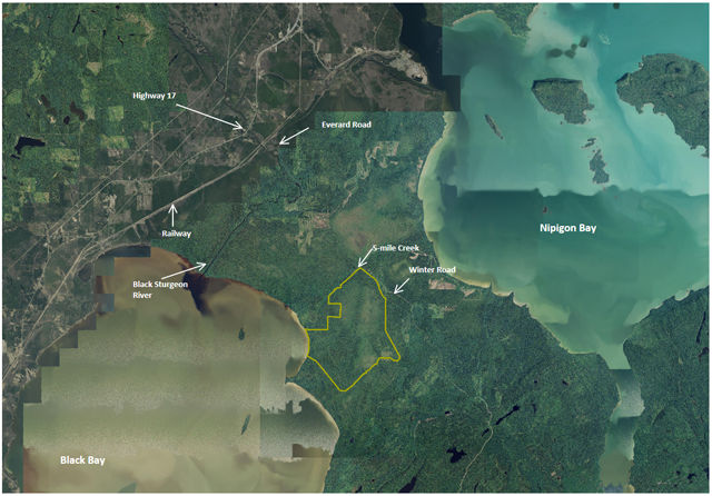
The location of the Black Bay Bog Conservation Reserve (C2243) is outlined in green.
Note the light greenish tone within the green outline - this indicates the peatland area. There is another peatland area visible just to the north-east of the reserve, which forms the rest of the provincially significant wetland complex.
Appendix 2: Site and values map of Black Bay Bog Conservation Reserve
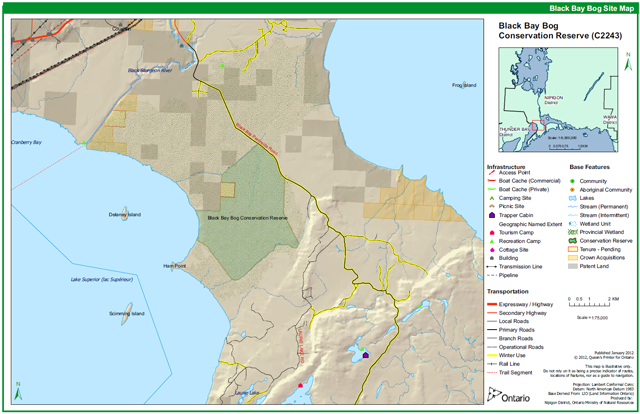
Enlarge Appendix 2: Site and values map of Black Bay Bog Conservation Reserve
Appendix 3: Permitted uses table
| Activity/Value | Permitted | Not Permitted | Modified | District Manager Approval |
|---|---|---|---|---|
| Sport Hunting | Yes | |||
| Commercial Trapping | Yes | |||
| Boating / Canoeing / Kayaking | Yes (N/A) | |||
| Baitfishing | Yes (N/A) | |||
| Commercial Wild Rice Harvest | N/A | |||
| Mineral Exploration & Extraction | Yes | |||
| Land Disposition for Private Purposes | Yes | |||
| All Terrain Vehicle | N/A | Yes | ||
| Snowmobile | N/A | Yes | ||
| Land Claims | N/A | Yes | ||
| Traditional Use | Yes | N/A | ||
| Native Hunt Camps | N/A | Yes | ||
| Commercial Tourism Based Hunting | Yes | N/A | ||
| Native Hunting | Yes | N/A | ||
| Commercial Native Trapping | Yes | N/A | ||
| Wildlife Management | Yes | N/A | ||
| Commercial Forest Operations | Yes | |||
| Vegetation Management (i.e. herbicides) | Yes | |||
| Timber Harvest for Personal Use | Yes | |||
| Fuelwood Harvest | Yes | |||
| Insect & Disease Suppression | N/A | Yes | ||
| Sport Fishing | Yes (N/A) | N/A | ||
| Commercial Fishing | Yes (N/A) | |||
| Native Fishing | Yes (N/A) | N/A | ||
| Water Control Structures | Yes | |||
| Aggregate Extraction | Yes | |||
| Bear Management Areas | Yes | N/A | ||
| Trapline Cabins | N/A | Yes | ||
| Wild Rice Harvest | N/A | |||
| Boat Caches | N/A | Yes (N/A) | ||
| Fire Management | Yes | N/A | ||
| Archeological Study | Yes | N/A | ||
| Backcountry Travel | Yes | N/A | ||
| Wildlife / Vegetation Viewing | Yes | N/A | ||
| Photography | Yes | N/A | ||
| Hiking | Yes | N/A | ||
| Rock Climbing | N/A | N/A | ||
| Mountain Biking | N/A | Yes | ||
| Nordic Skiing | Yes | N/A | ||
| Snowshoeing | Yes | N/A | ||
| Aircraft | N/A | Yes | ||
| Roads / Bridges / Culverts | N/A | Yes | ||
| Ongoing Research | Yes | N/A | ||
| New Research | N/A | Yes |
"Modified" – refers to a use which may be permitted under certain circumstances where the use would not impact the values for which the Conservation Reserve was created to protect (e.g. new trails, clearings/docks for aircraft access, etc.)
Wetland vegetation – Black Bay Bog Conservation Reserve
From left to right: Northern Bog Goldenrod (Solidago uliginosa) x2; Shrubby Cinquefoil (Potentilla fructicosa); Labrador Tea (Ledum groenlandicum); Bog Rosemary (Andromeda glaucophylla); American Grass-of-Parnassus (Parnassia glauca); Sticky False Asphodel (Tofieldia glutinosa); Tammarck (Larix laricina); Buckbean (Menyanthes trifoliata).
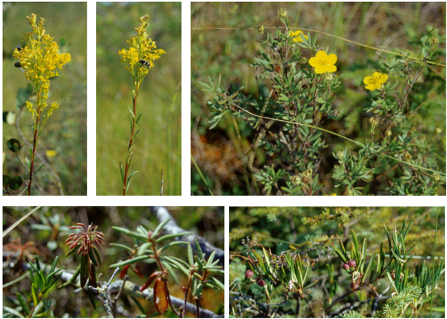
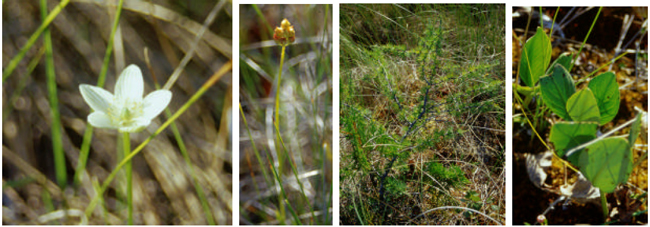
Sticky Asphodel, Shrubby Cinquefoil, Grass of Parnassus, and Northern Bog Goldenrod are all indicators of extremely rich fen conditions. Black Bay Bog is considered a provincially significant peatland complex. These photos were taken during an OLL site visit, on August 20, 2001.
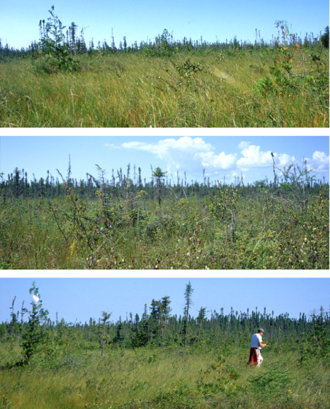
Black Bay Bog Conservation Reserve, August 20, 2001
The following three pictures show a typical open area in Black Bay Bog. Growing from the hummocks you could find: stunted tamarack and black spruce, as well as patches of dwarf birch, leatherleaf, sweet gale, and bog rosemary. Stands of mature black spruce typically surrounded these open areas.
English Sundew, Drosera anglica
These pictures, taken in Black Bay Bog Conservation Reserve, show English sundew (D. anglica), one of the four species of sundew found in Ontario. The other 3 species are: Round-leaved sundew (D. rotundifolia), Linear-leaved sundew (D. linearis), and Spatulate-leaved sundew (D. intermedia).
Sundews actually have more vitamin C than oranges and other citrus fruits. Since the 1500s, sundews were distilled with wine to make a liquor, called rosa solis, famous for its nourishing qualities (from: Up North Again, Bennet and Tiner)
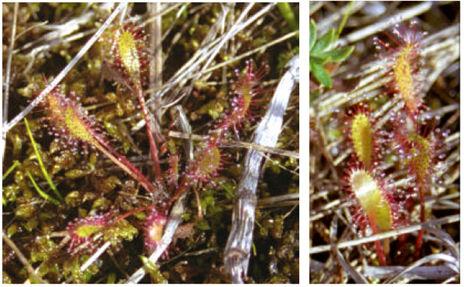
Adapted for living in nutrient-poor environments, the sundew has developed a unique method for obtaining much-needed nutrients:
Sundews are carnivorous plants, equipped with 'tentacles', tipped with sticky dew-like droplets. This sticky 'dew' attracts and captures unfortunate insects. When an insect touches the tentacles, they bend inward, forcing the insect into contact with even more sticky hairs. It can take 24 to 48 hours for the plant to completely enfold an insect victim. The 'tentacles' also secrete enzymes, which work to dissolve everything but the exoskeleton of the insect. As the enzymes digest the insect, a nutrient-rich pool accumulates. Once the insect is fully digested, this nutrient pool is absorbed into the leaf, and is distributed throughout the plant. Once the process is complete, the left-over exoskeleton is released and the leaf tentacles uncurl, ready for another meal.
In a unique twist, the sundew’s summer flowers are usually pollinated by the same unsuspecting flies that it devours.
Northern Pitcher Plant, Sarracenia purpurea
These pictures were taken in the Black Bay Bog Conservation Reserve, located at the northern base of Black Bay Peninsula, August 20, 2001.
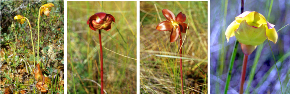
Pitcher Plants are one of the four carnivorous plant genera found in Ontario. In addition to the pitcher plant (Sarracenia spp.), Ontario is home to four species of sundew (Drosera sp.), a butterwort (Pinguicula sp.) and various species of bladderworts (Utricularia sp.).
Most of these plants live in harsh acidic environments, such as bogs and fens, where nitrogen and other essential nutrients are low and not readily available.
By evolving strategies to capture and digest insects, carnivorous plants found an alternate source of nitrogen and other essential nutrients, allowing them to grow and reproduce in areas where other plant species could not.
Carnivorous plant strategies:
Pitcher-Plants use pitcher-shaped leaves to entice, capture and digest their prey; Sundews employ many sticky, moveable 'tentacles'; Bladderworts use tiny, elastic-walled, balloon-like 'bladders' to capture insects and other aquatic invertebrates; and Butterworts have small glands on the surface of their leaves which secrete a sticky, glue-like substance.
Northern Pitcher Plant, Sarracenia purpurea
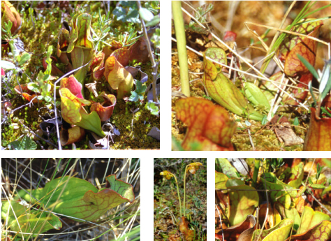
Pitcher plant leaves are designed to attract, catch and digest insects. Insects are attracted to these leaves by a musty odour and by the colour and patterning of the veins on the leaves. The hood-like lip and the upper inner surface of the 'pitcher' are covered with tiny, stiff, downward- pointing hairs. Insects, lured into this trap, easily move down into the pitcher, but are unable to climb out over the hairs. Eventually, the insects fall into the pool of liquid at the bottom of the cup and drown. This pool, made up of trapped rainwater and digestive enzymes released by the plant, slowly dissolve the prey. Nitrogen and other nutrients, released from the decomposing insect, are then absorbed by the plant. Pitcher plants have developed this strategy in order to survive in acidic habitats, such as bogs and fens, where the nutrient supply is typically low. Oddly enough, one insect, the larva of a small mosquito (Wyeomyia smithii), has evolved to live only in the water (and digestive enzymes) at the bottom of pitcher plant leaves.