Bryce and Cane Township Wetland Lacustrine Conservation Reserve Management Statement
This document provides policy direction for the protection, development and management of the Bryce and Cane Township Wetland Lacustrine Conservation Reserve and its resources.
Statement of Conservation Interest
May 2002
Kirkland Lake District
Ministry of Natural Resources
Approval statement
I am pleased to approve this Statement of Conservation Interest (SCI) for the Bryce and Cane Township Wetland Lacustrine Conservation Reserve.
Direction for establishing, planning and managing conservation reserves is defined under the Public Lands Act and current policy. Ontario’s network of natural heritage areas has been established to protect and conserve areas representative of the diversity of the natural regions of the province, including species, habitats, features and ecological systems which comprise that natural diversity.
(Policy 3.03.05, MNR 1997).
This SCI will provide guidance for the management of the conservation reserve and the basis for the ongoing monitoring of activities. More detailed direction at this time is not anticipated. Should significant facility development be considered or complex issues arise requiring additional studies, more defined management direction, or special protection measures, a more detailed Conservation Reserve Management Plan will be prepared with full public consultation.
The public was consulted on this site prior to its regulation during the planning for Ontario’s Living Legacy (MNR, 1999). Furthermore, the public was notified during a 30 day period in December, 2001 concerning a draft of this SCI. Comments from the notification period have been considered in the development of this document.
The conservation reserve will be managed under the jurisdiction of the Kirkland Lake/Claybelt Area Supervisor of the Ministry of Natural Resources, Kirkland Lake District.
Plan Author: Craig Fuller
Ontario’s Living Legacy Resource Manager
Kirkland Lake District
Approved by:
Craig Greenwood, District Manager
Kirkland Lake District
Date: July 8/02
Approved by:
Rob Galloway, Regional Director
Northeast Region
Date: Nov 25/02
1.0 Introduction
Ontario’s network of natural heritage areas has been established to protect and conserve areas representative of the diversity of the natural regions of the province, including species, habitats, features and ecological systems which comprise that natural diversity. Protected natural heritage areas are a key component in sustainable management of natural resources. They ensure that representative sites within the larger sustainably managed landscape are permanently retained in their natural state.
These areas are considered to be sensitive, requiring protection from incompatible activities if their values are to endure over time. The Ministry of Natural Resources has established conservation reserves as a new tool to offer protection for natural heritage areas on public lands, while permitting many traditional public lands uses to continue. Such uses include the traditional activities of Aboriginal peoples.
Ontario’s Living Legacy Land Use Strategy (OLL LUS MNR, 1999) will set the direction for the administration and management of parks and protected areas on Crown lands within three planning regions including; the Boreal West, Boreal East and Great Lakes- St. Lawrence areas. This strategy’s natural heritage objectives include protection of natural and cultural heritage values and the provision of opportunities for outdoor recreation, heritage appreciation and tourism (MNR, 1999).
Protected areas designated within the (OLL LUS MNR, 1999) have been selected based on their representation of the spectrum of the province’s ecosystems and natural features including both biological and geological features, while minimizing impacts on other land uses. Representation was described using landform and vegetation combinations based on Hill’s (1959) site district concept. For the Bryce and Cane Wetland Lacustrine Conservation Reserve (C1613), lacustrine and organic deposits with wetlands and a mix of predominately coniferous or deciduous stands dominate the site.
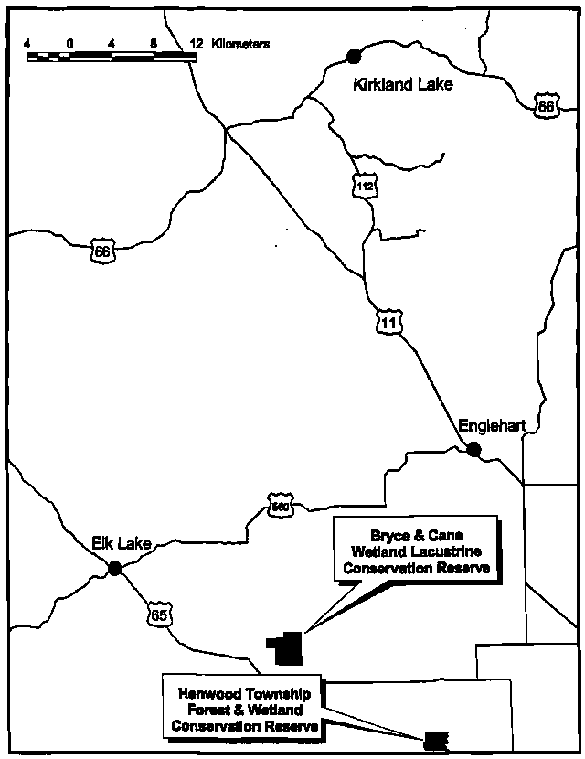
The Bryce and Cane Township Wetland Lacustrine Conservation Reserve is located approximately 18 km southeast of the town of Elk Lake, Ontario just north of Highway 65 (See Location Map, Appendix 7). The conservation reserve, which is situated within the OLL Boreal East Planning Region, has an area of 655 ha. and is located within the Townships of Bryce and Cane. These two townships are situated in the Kirkland Lake District within the MNR’s Northeast Region. The conservation reserve will be managed under a Statement of Conservation Interest (SCI).
Statement of Conservation Interest (SCI) documents are the minimum level of management direction established for any conservation reserve and generally are brief management plans. This SCI will govern the lands and waters within the regulated boundary of the conservation reserve. However, to ensure MNR protection objectives are being fully met within the conservation reserve, the surrounding landscape and related activities must consider the site’s objectives and heritage values. In addition, it is the intent of this SCI to create a public awareness that will promote responsible stewardship of protected areas and surrounding lands. With management partners such as Ontario Parks, industry, local governments, etc., MNR District Offices will be able to pursue and advance sound environmental, economic and social strategies and policies related to the protection of conservation reserves and provincial parks.
The purpose of this SCI is to identify and describe the values of the Bryce and Cane Township Wetland Lacustrine Conservation Reserve and outline the Ministry’s management intent for the conservation reserve. The management direction will protect the site’s natural heritage values and demonstrate its compatibility within the larger sustainable landscape. This direction will comply with land use intent as stated by the OLL Land Use Strategy (MNR, 1999).
2.0 Goals and objectives
2.1 Goals of Statement of Conservation Interest
The goals of this SCI will be to describe and protect natural heritage values on public lands while permitting compatible land use strategies.
2.2 Objectives of SCI
2.2.1 Short term objectives
To identify the State of the Resource with respect to natural heritage values and current land use activities for the conservation reserve. A priority will be placed on the protection of the site’s natural values via specific guidelines, strategies and prescriptions detailed in this plan. Finally legislated planning requirements will be met (e.g. SCI development within three years of regulation).
2.2.2 Long term objectives
The long-term objectives will be to establish representative targets (e.g. future forest conditions) and validate the site as a potential scientific benchmark. To ensure protection of natural and cultural heritage features and values, this SCI will establish an evaluation process to address future new uses and commercial activities associated with them (e.g. Test of Compatibility Procedural Guideline B in Conservation Reserve policy PL 3.03.05). Finally, this SCI will identify research/client services and marketing strategies.
3.0 Management planning
3.1 Planning area
The planning area for this site will consist of the regulated boundary for the Bryce and Cane Wetland Lacustrine Conservation Reserve (See Land Use Map, Appendix 7)
This land base will form the area directly influenced by this Statement of Conservation Interest. The plan will recognize the protection of values within the planning area; however, to fully protect values within the conservation reserve additional consideration within larger land use or resource management plans may be required. Nevertheless, any strategies noted within this plan related to the site’s boundary or beyond will need to be presented for consideration within a larger planning context.
3.2 Management planning context
The Bryce and Cane Township Wetland Lacustrine Conservation Reserve was designated as a candidate conservation reserve by MNR in the OLL Proposed Land Use Strategy (MNR, March 1999) and eventually as a conservation reserve in the fmal OLL Land Use Strategy (MNR, 1999). The site was regulated under an amendment of Ontario regulation 805/94 made under the Public Lands Act on April 6, 2001. Management and planning direction for this site will be via the OLL LUS (MNR, 1999) and this management statement. The area encompassed by this site has also been removed from the Sustainable Forest License (SFL) landbase.
By regulation this conservation reserve cannot be used for commercial forest harvest and hydroelectric power development. Currently no mining tenure exists within the site and the site has been withdrawn under the Mining Act. Existing permitted uses within this reserve will continue to be permitted, therefore such activities as sport hunting and fishing are permitted to continue. This SCI and future management will continue to try and resolve conflicts regarding incompatibility between uses and to ensure that identified values are adequately protected.
This Statement of Conservation Interest will only address known issues or current proposals with respect to permitted uses or potential economic opportunities brought forward to the District Manager during this planning stage. However, in terms of approving future permitted uses and/or development(s), there are established mechanisms in place to address such proposals. Any future proposals will be reviewed using the Procedural Guideline B -Land Uses- Test of Compatibility Public Lands Act Policy PL 3.03.05 (MNR, 1997) or other standard MNR environmental screening processes.
Consideration for proposals pertaining to cultural resources may be screened through Conserving a Future for our Past: Archaeology, Land Use Planning & Development in Ontario, Section 3 (MCzCR, 1997) and MNR’s history in establishing AOC descriptions and prescriptions for cultural heritage resources within forest management plans (FMPs).
These planning tools will help refine the review process once the proposal satisfies the direction and intent of the Public Lands Act, associated policies and this planning document.
3.3 Planning process
Once a Conservation Reserve is passed into regulation, it must be determined what level of management planning is required to fulfill the protection targets. There are two policy documents involved. A Statement of Conservation Interest (SCI) is the minimal requirement for providing planning direction, and a Resource Management Plan (RMP) that deals with more complex issues where several conflicting demands are placed on the resources. The guidelines for the preparation of these documents is outlined in Procedural Guideline A- Resource Management Planning (Conservation Reserves Procedure PL3.03.05 Public Lands Act). The appropriate plan must be completed within three years of the regulation date.
For current planning purposes, the Bryce and Cane Township Wetland Lacustrine Conservation Reserve will be managed under the auspices of a Statement of Conservation Interest. Interested parties from both the private and public sectors were consulted during the OLL planning process from candidate conservation reserve to regulation. The intent of this SCI is to fulfil the commitments made within the OLL LUS (MNR, 1999). In addition, a public notification of a draft of this SCI document occurred for a period of 30 days during January 2002. During this period, the MNR received no new permitted use or development proposals for this conservation reserve. Therefore, no new decisions have been identified by the MNR since the implementation of the OLL strategy.
The revised SCI was reviewed by the Kirkland Lake District Manager (DM). Upon approval by the DM the SCI was presented to the Regional Director (RD) for final approval.
Following RD approval, interested public, user groups and industry were notified that the Statement of Conservation Interest for the Bryce and Cane Wetland Lacustrine Conservation Reserve was approved.
Public consultation will be solicited during a review of any future land use proposals that would require new decisions to be made. In addition, any future proposal and/or any new, significant management direction considered will be published on the Environmental Bill of Rights Registry (EBR).
The SCI is a policy document that will provide background information, identify values to be protected and establish management guidelines for use in the administration of the reserve.
The implementation of the policy will be the mandate of the MNR at the district level, however associations with various partners may be sought to assist in the delivery. This SCI is a working document; therefore it may be necessary to make revisions to it from time to time.
4.0 Background information
4.1 Location and site description
4.1.1 Location
The following table describes the location and provides administrative details of the site:
| Name | Bryce and Cane Township Wetland Lacustrine Conservation Reserve |
|---|---|
| Site Region- Site District (Hills) | 4E Lake Temagami- 4E-5 New Liskard |
| Site Region- Site District (Crins and Uhlig) | 4E-5 |
| MNR Administrative Region/District/Area |
Northeast Region/Kirkland Lake District in the Kirkland/Claybelt Area |
| UTM co-ordinates | E 567500 N 5280000 |
| Nearest Town/Municipality | Southeast of Elk Lake and the Municipality of James |
| Township(s) | Townships of Bryce and Cane |
| OBM Numbers | 17 5600 52700 / 17 5600 52800 |
| Topographical Map Name/Number | Elk Lake / 41 /P19 |
| Wildlife Management Unit | 28 |
| Forest Unit | Timiskaming Forest |
Table 1: Location Data
4.1.2 Site description
4.1.2.1 Physical description
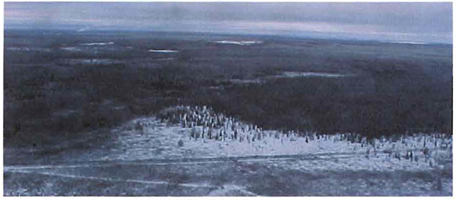
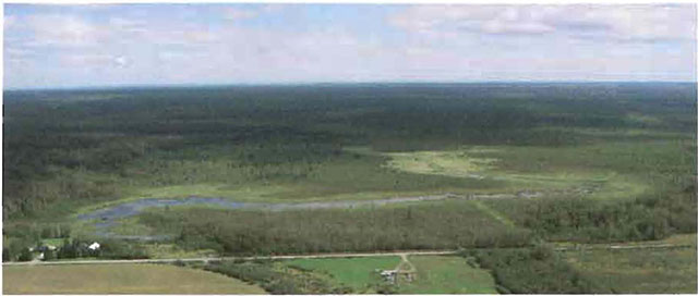
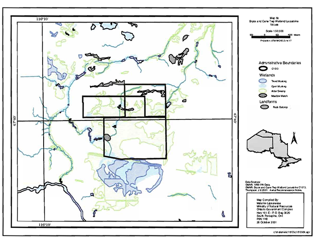
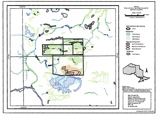
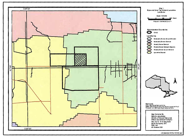
Bryce and Cane Township Wetland Lacustrine Conservation Reserve is a 655 ha parcel of Crown land that is situated just north of Highway 65 and approximately 18 km southeast of the town of Elk Lake. The conservation reserve is unevenly bisected with the smaller northern portion contained within Bryce Township with the remainder within Cane Township. It is located on the edge of Hill’s (1959) Site District 4E-5 an undulating clay plain (i.e. The Little Clay Belt) enclosed by Precambrian ridges with shallow mantels and deep pockets of sand, silt and localized clay areas (MNR, 1992). This description matches Rowe’s (1972) description of the Haileybury Clay Forest Section. Forests are transitional between the Great Lakes St. Lawrence and the Eastern Boreal Forest Regions. Black spruce is characteristic on lacustrine deposits and in association with balsam fir, white birch and trembling aspen. Major disturbance is by fire or by agricultural clearing (Rowe, 1972).
The key values within the conservation reserve include the following;
- Alder thickets and shrub and open wetland;
- Black spruce dominated stand associated with glaciolacustrine silt and clay;
- Trembling Aspen mixedwood associated with bedrock outcrop;
The site is drained through its wetland complex and a human made ditch in the southwest corner of the site which lead to a small tributary that leads to the Montreal River just east of Mountain Chutes. Besides the dominated alder and willow shrub, complex meadow marshes and shoreline fen areas add to the diversity of the site.
4.2 Administrative description
The legal boundaries of the Bryce and Cane Township Wetland Lacustrine Conservation Reserve were filed on January 11, 2001 in the Office of the Surveyor General, Ministry of Natural Resources in Peterborough, Ontario. The site was regulated on April 6, 2001. Presently the conservation reserve is located within the Sustainable Forest License of the Timiskaming Forest Alliance Inc. (TFAI).
4.3 History of Site
Historically the site has been used for commercial fish and wildlife activities. The site contains portions of two Bear Management Areas, two baitfish areas and two traplines. Most of the northern portion of the site was harvested in the winter of 1998/99. Four timber harvest blocks, running west to east, are located north of the site in Bryce Twp. Other harvest blocks have also been identified to the north and northeast of the site in the 2001-2021 FMP for the Timiskaming Forest.
4.4 Inventories
The following table indicates the current status of natural heritage inventory that has occurred or is required in the near future:
| Survey Level | Earth Science | Life Science | Cultural | Recreational | Other |
|---|---|---|---|---|---|
| Reconnaissance | August 2001 | August 2001 | Not required at this time. | June/July 2001 August 2001 |
|
| Detailed | |||||
| Requirement | Silvicultural assessment of the old clear cut areas in northern portion of the site. Additional life science inventory to define values is required. |
Table 2: Inventory Data
5.0 State of the resource
Representation:
Bryce and Cane Township Wetland Lacustrine Conservation Reserve is located within the low hummocky terrain of the Cobalt plain which contains flat lying sedimentary Precambrian bedrock (Bostock 1970). Life science gap analysis
Modification of the site’s boundary through the regulation process eliminated any jack pine community influence that was represented in the gap analysis for the site. Aerial reconnaissance surveys completed in August 2001 showed a significantly different landform mosaic than described in the 1998 analysis. The site was found to contain three (3) major landform types. Organic deposits dominate the central and southern halves of the site and contain the major wetland communities. The northern portion is glacial lacustrine which contains not sufficiently generated poplar and white birch mixed woods and assorted wetland communities. The northeastern corner contains bedrock and exposed rock of sparse white birch forest and poorly regenerated poplar. No outwash deposits as noted in the 1998 gap analysis are contained within this site.
The site is drained by its wetlands that lead to a small creek, which is a tributary of the Montreal River. A human-made ditch is located in the southwest comer of the site that leads into this meandering and wetland choked creek. Beaver dams and meadow marshes
Quality of Representation:
The quality of the representation for the current characteristics of the natural features found within the conservation reserve are as important as the overall representative features that are being protected. A number of factors are considered in evaluating a site and they include the following criteria; diversity, condition, ecological factors, special features and current land use activities.
-
Diversity:
Diversity is evaluated in terms of the number and range (i.e. amount of richness and evenness) of vegetative communities currently present within the conservation reserve. Natural landscapes and known generalized vegetative communities will be the scale used for this Statement of Conservation Interest. Future aerial or ground reconnaissance surveys will enhance the MNR’s knowledge of these features and possibly allow verification at a lower scale (e.g. species assemblages).
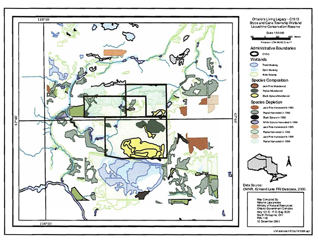
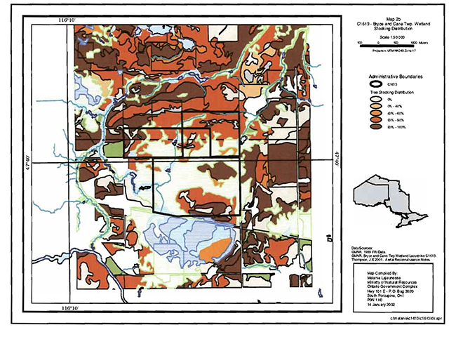
Based on the reconnaissance survey completed in August 2001, this site’s diversity is relatively poor due to its small size, past disturbance, few landform and vegetative community combinations present and the dominance of a couple of communities. Its evenness is heavily skewed towards thicket swamp communities on organic soils and not sufficiently generated poplar and white birch stands on glaciolacustrine or bedrock landforms. (See Forest/Wetlands Values Maps, Appendix 7)
-
Condition:
Condition is the degree of past human and natural disturbances observed or recorded for the site. Much of the poplar mixedwood stands along the northern boundary have been cut with white birch and young poplar remaining in a more open landscape. Access trails and old roads occur within these harvested areas; however, their degree of development is very poor. A small human-made ditch is present in the southwest comer of the site.
-
Ecological Factors:
Ecological factors refer to the current design of the conservation reserve as noted by its size, shape, buffering capacity to adjacent land use activities. In addition the site’s current linkage to undisturbed landscapes also contribute to the conservation reserve’s ecological integrity. Presently the site is surrounded by patent lands along all boundaries except two short distances along the northern boundary. As a result of the patent land fabric the site contains non-biological or vectored boundaries and the site is cut off from additional Crown lands. The site’s design is further weakened by the presence of a private land block located within the north central portion of the site where natural heritage values have been altered to a small extent and may eventually be lost over time.
-
Special Features:
Due to the site’s small size and the dominance of poor quality wetlands and disturbed deciduous stands the number of special features present is limited to the life science representation previously discussed. Wildlife features include possible moose calving sites and the presence of cold water streams. Finally, undisturbed communities present on the site are still highly valued since most of the vegetative communities present within Site District 4E-5 have been effected by agricultural or other human developments.
-
Current Land Use Activities
Only a small number of current uses are known to be associated with this site. Activities include trapping, hunting, baitfish harvesting and snowmobiling. Some trail and old forest industry access is associated with the disturbed areas in the northern portions of C1613.
Summary:
Bryce and Cane Township Wetland Lacustrine Conservation Reserve contribution to the parks and protected areas system must be reviewed in light of new landform information previously mentioned to determine the site’s provincial significance. Furthermore the site’s small size, relatively low diversity and significant amount of disturbed areas suggest that future management may need to consider monitoring successional changes or possibly developing a restoration ecology strategy for the site. Regardless of the earth or life science values currently present, the site does contribute some undisturbed wetlands and forest stands which are valued within the heavily disturbed Site District 4E-5.
Natural heritage representative features
This site contains weakly broken outwash with brush and alder, trembling aspen (middle), spruces (middle to young), rock, open wetland and jack pine (middle). It also has lacustrine deposits with brush and alder, trembling aspen (young), and open wetland. The following table indicates the landforms present and the associated vegetation cover.(see section 5.2 for further information.)
Landform- Vegetation (LV) Type
| Landform | Vegetation |
|---|---|
| Weakly Broken Outwash Deposits | Brush and Alder |
| Weakly Broken Outwash Deposits | Jack Pine (middle) |
| Weakly Broken Outwash Deposits | Open Muskeg |
| Weakly Broken Outwash Deposits | Trembling Aspen |
| Weakly Broken Outwash Deposits | Rock |
| Weakly_ Broken Outwash Deposits | Spruces (middle) |
| Weakly Broken Outwash Deposits | Spruces (young) |
| Lacustrine Deposit | Brush and Alder |
| Lacustrine Deposit | Open Muskeg |
| Lacustrine Deposit | Trembling Aspen (young) |
Table 3: Vegetation types
Forest Resource Inventory (FRI) Data
- Dominant species. wetlands and depleted areas
- See Forest Stand Composition Map, Appendix 7
Values
- Research trials (bordering site to the south)
- Moose calving sites (suspect)
- Deer habitat range
- Cold water fish species streams
5.1 Social/economic interest in area
- Linkage to Local Communities:
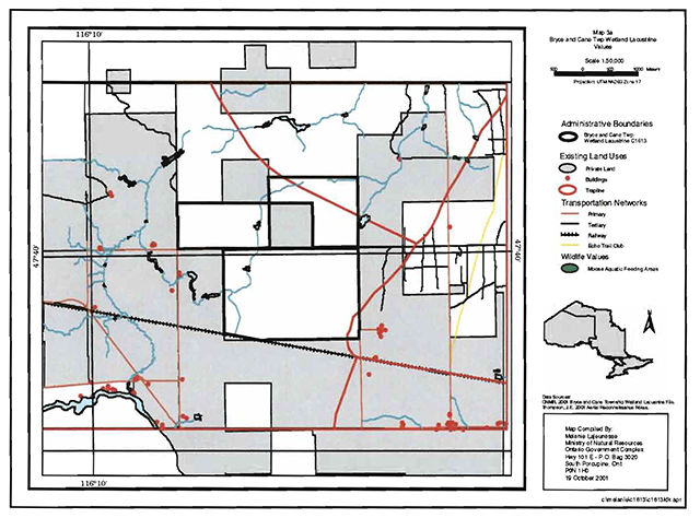
The Bryce and Cane Township lacustrine Conservation Reserve consists entirely of Crown land and is easily accessible via concession roads, north of Highway 65, along the western boundary and southeast comer of the site and by a snowmobile trail along the old Ontario Northland Railway. The site encircles a patented land block, which is located just north of the center of the site. (See Land Use Map, Appendix 7)
Current uses are related to consumption of fish and wildlife resources and snowmobiling. Potential recreational activities could include ATV riding and possibly non-consumptive uses such as bird watching or nature study. The present condition of the wetlands would make access into some of these areas difficult due to water levels and density of growth. In its present condition, the social and economic interest in the area is not likely to be expanded beyond the current uses.
- Heritage Estate Contributions:
The Bryce and Cane Township Wetland Lacustrine Conservation Reserve Conservation Reserve contributes to the province’s parks and protected areas system through its regulation, representation and the long-term management of its natural heritage values.
By allocating these lands to the parks and protected areas system through regulation, the province has ensured a certain level of permanence by distinguishing the site and its values from the larger general use or more extensively managed landscape. In addition, its natural features are, and will be available for present and future generations to enjoy and explore.
The site’s representation makes a minimal contribution to the province’s natural heritage estate. The glaciolacustrine wetlands and poplar mixedwood stands are considered provincially significant
footnote 5 Additional analysis will have to be completed to see if the black spruce and wetland communities over organic soils and poplar mixed woods over bedrock are provincially significant. The existence of any undisturbed landscapes contributes to the natural heritage estate values for this heavily developed Site District. However, the site’s small size, dense wetlands within the southern portions of the site and disturbed poplar mixedwood areas along the northern boundary do not contribute significantly to a wide assortment of current or potential recreational activities.Long term management must consider public access to the site, the conservation reserve protection objectives, and commitments made in the OLL strategy (MNR 1999). Future managers will have to consider if restoration ecological actions are required within the disturbed zones or whether natural vegetative succession and long term monitoring of these disturbed areas is more appropriate (see section 6.2 Natural Heritage Stewardship).-
- Aboriginal Groups:
The aboriginal groups in the area have not currently identified any traditional use areas or areas of interest within the site. However, the site is situated within the Temagami First Nation land claim area.
- Mining Interests:
There are no known current mining interests related to the conservation reserve. Mining and surface rights have been withdrawn from staking within the conservation reserve’s boundaries under the Mining Act (RSO 1990 Chapter M.14).
- Forest and Fire Management History:
The site has been affected by recent forest management activities. In 1986 a small poplar stand was harvested in the northwestern section of the site (approximately 7 ha).
However most of the northern portion of the site was harvested in 1999 (approximately 140 ha.) prior to the OLL Land Use Strategy (MNR 1999) and the interim protection standards. In addition a number of abandoned forest extraction roads exist in the northern segment of the site. (See Forest Species Value Map, Appendix 7)
The site has no recent burned areas within it boundary.
5.2 Natural heritage stewardship
Preliminary analysis of the life science targets based on landform/vegetation combinations showed the site contained 10 such combinations. A recent aerial reconnaissance survey showed significant pre-OLL harvest areas located throughout the northern portion of the site. In addition over 88% of the site was incorrectly coded for earth science features. A total of three earth science landform features exist within the site including organic deposits, glaciolacustrine deposits and bedrock features. No outwash deposits occur within the site.
The number of landform/vegetation combinations, which includes known forest stands and wetlands, exceeds expectations as a result of the gap analysis. However, a number of vegetative communities gained were also severely impacted due to recent harvesting.
No permanent MNR sampling plots are associated with the site.
5.3 Fisheries and Wildlife
There have been no detailed wildlife studies with the exception of some values assessment for the site and surrounding area. The Fish and Wildlife Values identified are moose calving sites, deer habitat range and cold-water fish species streams. Fishing opportunities are limited due to the lack of watercourses and lakes.
Some of the habitats associated with wildlife are wetlands and black spruce and aspen stands. All of these habitats, as well as the sections that have been harvested, provide year round habitat for moose as well as other species. The shoreline fen and beaver meadow areas provide excellent forage and breeding/nesting areas for waterfowl. However, much of the thicket swamp areas of alder and willow that dominate most of the organic soils in the south are of limited value for waterfowl.
5.4 Cultural heritage stewardship
To date, a detailed assessment of cultural resources has not been carried out.
5.5 Land use/existing development
The conservation reserve rests on Crown land and is unencumbered by any land use permits, leases or mining claims. Mining and surface rights have been withdrawn from the reserve (MNDM G-Plan M-0282 December 12, 2001). There are no identified development or current structures located within the boundaries of the site. The decommissioned rail line that is not included in the site runs along the southern border. The Ontario Federation of Snowmobile Clubs presently uses this rail line as a snowmobile trail.
5.6 Commercial use
Present commercial use activities include two traplines (KL-85 and KL- 91), two bear management areas (BMAs KL-40-15 and KL-28-46) and baitfish operations (Baitfish Blocks- KL-19 and KL-14). (See Land Use Map, Appendix 7)
5.7 Tourism/recreation use/opportunities
Some of the features within this site associated with the possible recreation use include wetland vegetation, aquatic flora and fauna, large and small land mammals and mixed forests. Existing recreational uses in this site and the immediate area surrounding the site include trapping, large game hunting, small game hunting and snowmobiling. There is also potential for activities such as ATV use, bird watching and nature study.
For a more detailed report and summary of the recreational use and potential refer to the Recreational Inventory Check-sheet.
5.8 Client services
Currently visitor services are limited to responding to inquiries about access, natural heritage features and boundaries. No formal information or interpretive facilities currently exist within the conservation reserve.
Other client services include providing clients with maps, fact sheets and other information gathered on the area, such as the Earth/Life and Recreational inventory work.
6.0 Management guidelines
6.1 Management planning strategies
The land use intent outlined in the OLL LUS (MNR, 1999) provides context and direction to land use, resource management, and operational planning activities on Crown land. Commitments identified in the above strategy and current legislation (Policy 3.03.05 PIA) will form the basis for land use within Bryce and Cane Township Wetland Lacustrine Conservation Reserve. Management strategies for these uses must consider the short and long-term objectives for the reserve. For up to date information on permitted uses refer to the Crown Land Use Atlas.
Proposed uses and development will be reviewed on a case-by-case basis. A Test of Compatibility, (Procedural Guideline B-Land Uses (PL 3.03.05) must be passed before they are deemed acceptable. The emphasis will be on ensuring that the natural values of the conservation reserve are not negatively affected by current and future activities. Therefore any application for new specific uses will be carefully studied and reviewed.
6.2 State of the resource management strategies
The development of this SCI and the long term management and protection of Bryce and Cane Township Wetland lacustrine Conservation Reserve will be under the direction of the MNR’s Kirkland Lake District, Kirkland Lake/Claybelt Area Supervisor. The following management strategies have been created to achieve the goal and objectives stated earlier in this management document.
Natural heritage stewardship
The management intent for the Bryce and Cane Township Wetland Lacustrine Conservation Reserve is to allow for natural ecosystems, processes and features to operate undisturbed with minimal human interference while providing educational, research and recreational activities. Forest ecosystem renewal will only be entertained via a separate vegetative management plan. As part of any future vegetative management plan the site and its Site District will be re-evaluated with respect to their known landform/vegetative features to determine if the past harvested areas could contribute additional landform/vegetative values to the Site District. In addition the vegetative management plan will need to determine but not be limited to;
- the restoration ecology objectives (e.g. representation) for the area in context with the Site District;
- consider current provincial strategies (e.g. white pine);
- consider larger long-term conservation reserve (e.g. recreational objectives) and possibly landscape objectives (e.g. contributions to landscape wildlife objectives).
Forest fire protection will be carried out as on surrounding public lands, under the direction of the provincial fire strategy. All wildfire occurrences will be considered a high priority and will actively be suppressed. Prescribed burning will be conducted only under the direction of the provincial fire strategy and authorized for the conservation reserve under a separate vegetative management plan. Prescribed burning may be utilized if deemed necessary to emulate natural disturbances and renew forest communities, prepare seed beds for research and/or education purposes or to meet additional objectives determined within a separate vegetative management plan.
Defining compatible uses, enforcing regulations and monitoring and mitigating issues will protect all earth and life science features. Industrial activities such as; commercial timber harvest and new hydro generation will not be permitted within the conservation reserve. Permits for fuel-wood will not be issued. Energy transmission, communication and transportation corridors or construction of facilities are not permitted within the boundaries of the conservation reserve. Such structures negatively impact on the quality of the representative features that require protection. Alternatives should be reviewed via larger landscape planning processes. Other activities that do not pass a Test of Compatibility will be prohibited (MNR Policy 3.03.05, 1997).
The introduction of exotic and/or invasive species will not be permitted. Programs may be developed to control forest insects and diseases where there is a concern that significant values may be compromised. Remedies must focus on the outbreak or infestation. Biological or non-intrusive solutions should be applied whenever possible. The collection/removal of vegetation and parts thereof will not be permitted; however, subject to a Test of Compatibility, the Area Supervisor may authorize such activities for purposes of rehabilitating degraded sites within the reserve, collecting seeds for maintaining genetic stock and/or for inventory or research purposes.
Silvicultural assessment of the previous clear-cut areas in the northern portion of the site should be conducted to support any future vegetative management plan. The evaluated should consider but not be limited to the following objectives:
- describing the current forest condition;
- determining soil type and depth;
- defining potential restoration prescriptions. Such prescriptions must consider current silvicultural science and guidelines and additional objectives established by the MNR.
MNR will provide leadership and direction for maintaining the integrity of this site as a heritage estate. To ensure MNR protection objectives are fully met within the conservation reserve, activities on the surrounding landscape must consider the site’s objectives and heritage values. Research, education and interpretation will be encouraged to provide a better understanding of the management and protection of the natural heritage values and will be fostered through local and regional natural heritage programs, initiatives and partnerships.
The conservation reserve will be managed by allowing natural ecosystems, processes, and features to operate normally, with minimal human interference.
Fisheries and Wildlife
Fishery and wildlife resources will continue to be managed in accordance with specific policies and regulations defined by the Ontario Ministry of Natural Resources under the Fish and Wildlife Conservation Act and the Kirkland Lake District, Kirkland Lake/Claybelt Area Supervisor.
Fishing and hunting will continue at a low level of intensity. Wildlife viewing activities may be enhanced by a planned trail and viewing area development. Any future trail development will require a test of compatibility and an amendment to the Statement of Conservation Interest.
Cultural heritage
When possible, the Ministry of Natural Resources will continue to work with the Ontario Ministry of Culture, Tourism and Recreation in identifying archaeological sites to be protected. To more fully manage and protect sites, the development of field surveys would be required. However at this time additional field surveys are not recommended.
Development, research and education proposals may be considered in accordance with the Test of Compatibility; Conserving a Future for our Past: Archaeology, Land Use Planning & Development in Ontario, Section 3 (MCzCR, 1997).
Land use and development
The sale of lands within the conservation reserve is not permitted as per the OLL LUS (MNR, 1999). Existing authorized trails can continue unless there are significant demonstrated conflicts. New trails will only be allowed if a Test of Compatibility is passed. Any new trail development will require an amendment to the SCI. The cutting of trees for non-commercial purposes (e.g. fuelwood) is not permitted unless as a result of permitted development activity (e.g. trail, viewing site, etc.).
New roads for resource extraction will not be permitted and abandoned forest extraction roads will not be actively maintained.
Commercial use
All existing commercial bait fishing and commercial bear hunting (within BMAs) operations are permitted to continue. Commercial bear hunting operations, for non-residents, is permitted and the transfer of existing licenses is allowed.
Existing commercial fur harvesting operations are permitted to continue. New operations may be considered subject to a Test of Compatibility. No new trap cabins will be permitted.
Aboriginal interests
The Bryce and Cane Township Wetland Lacustrine Conservation Reserve is within the Temagami First Nation land claim area. The District will comply with any input resulting from the final negotiating land claim. Aboriginal and treaty rights will continue to be respected.
Tourism/Recreation
The earth and life science features and their protection, shall be the overall theme tor tourism. Small-scale infrastructures for enhancing tourism and recreation (i.e., warm-up shelter) may be considered, providing they pass a Test of Compatibility and other MNR requirements.
Most recreational activities that have traditionally been enjoyed in an area can continue provided they pose little or no threat to the natural ecosystems and features protected by the Conservation Reserve. These permitted activities include walking, hiking, wildlife viewing, fishing, hunting, snow shoeing, and cross-country skiing.
Snowmobiles and All-Terrain Vehicles (ATVs) are permitted on existing trails and forest access roads within the Conservation Reserve. Under the OLL LUS (MNR, 1999), all mechanized travel is restricted to existing trails. Off trail vehicle use is permitted for the retrieval of game only.
Existing trails for hiking, snowmobiling, ATV use, cycling, horse riding and cross-country skiing can continue pending they do not impact or degrade values located within the site. To ensure the quality of the representation is maintained, all trails and old forest access roads within the site should be identified via new technologies (i.e. GPS) to ensure a record of these features exist. New trails can be considered through a Test of Compatibility. If new trails are approved then an amendment to the SCI will occur.
Finally, conflict resolution between recreational uses will be a priority. This will be achieved by adhering to the objectives of this SCI with input from relevant user groups. The level of safety and compatibility between activities will determine permitted uses (i.e., Test of Compatibility).
Client services
Clients indicating their interest in the management, planning and future use in the conservation reserve will be put on a mailing list and notified of any future planning in the site.
Present client services such as supplying maps, fact sheets and other information will also continue. Information may be delivered from different sources, however, MNR will be the lead agency for responding to inquiries regarding access permitted and restricted activities, values and recreation opportunities. A management agreement may be pursued with an appropriate partner to share responsibilities for information services and the delivery of other aspects of this SCI in the future.
6.3 Specific feature/area/zone management strategies
There are no specific management strategies for the maintenance/protection/enhancement of selected resources within the conservation reserve. Development of such strategies will require an amendment to the SCI.
6.4 Promote inventory, monitoring and assessment reporting (IMAR), and research
Scientific research by qualified individuals, which contributes to the knowledge of natural and cultural history and to environmental and recreational management, will be encouraged.
Additional life science inventory or research is required at this time to refme values and features. Additional assessment and monitoring of the disturbed areas, including trail and old road locations, within the site should occur prior to any additional management direction developed via a vegetative management plan for the area.
Research related to the study of natural processes will be encouraged provided it does not harm the values of the reserve. The Kirkland Lake/Claybelt Area Supervisor may approve the removal of any natural or cultural specimen by qualified researchers. All such materials removed remain the property of the Ministry of Natural Resources. All research programs will require the approval of the Ministry of Natural Resources and will be subject to Ministry policy and other legislation.
New research developments such as campsites, privies, trails or developed access points or activities will not be considered until a Test of Compatibility is conducted and proposal is approved by the Kirkland Lake/Claybelt Area Supervisor. The Test of Compatibility or environmental screening process could include a review of the demand for structures or activities and may require more detailed life or earth science or cultural information and possibly more detailed management plan.
Approved research activities and facilities will be compatible with the protection objective. Permanent plots or observation stations may be established to which researchers can return over time. Any site that is disturbed will be rehabilitated as closely as possible to its original state.
6.5 Implementation, and plan review strategies
Bryce and Cane Township Wetland Lacustrine Conservation Reserve Statement of Conservation Interest will be reviewed on an ongoing basis and as required.
Implementation of the SCI and management of the reserve are the responsibility of the Area Supervisor. Partnerships may be pursued to address management needs.
If changes in management direction are needed at any time, the significance of the changes will be evaluated. Minor changes that do not alter the overall protection objectives may be considered and approved by the District Manager without further public consultation and the plan will be amended accordingly. In assessing major changes, the need for a more detailed Conservation Reserve Management Plan will first be considered. Where a management plan is not considered necessary or feasible, a major amendment may be considered with public consultation. The Regional Director will approve major amendments.
6.6 Marketing strategies
Bryce and Cane Township Wetland Lacustrine Conservation Reserve will be marketed as a representative natural area having earth and life science values, as well as certain recreational values. Marketing efforts to increase use are not a priority and will be kept to a minimum.
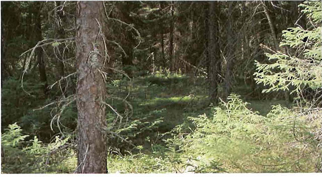
Figure 3. Black spruce (Picea mariana) stand in the southeast portion of the site. Species associated with this stand include tamarack (Larix laricina), balsam flr (Abies balsamea), Labrador tea (Ledum groenlandicum), goldthread (Coptis trifolia), buncbberry (Comus canadensis), baircap mosses (Polytrichum spp.), peat mosses (Sphagnum spp.) as well as others. Photo taken August 13, 2001
6.7 Boundary identification
There is no stated policy requirement to mark the boundaries of a Conservation Reserve. Local management discretion can be used to determine where boundary marking may be appropriate. In order for restrictions to be enforceable, signs must be placed in accordance with the Trespass to Property Act or subsection 28 (1) of the Public Lands Act to advise of any restricted recreational activities.
7.0 References
_.1983. Ontario Ministry of Natural Resources. Kirkland Lake District Land Use Guidelines.
_.1990. Trespass to Property Act. Government of Ontario. Queen’s Printer. Toronto.
_.1992. Mining Act. Government of Ontario. Queen’s Printer. Toronto.
_.1993. Public Lands Act. Government of Ontario. Queen’s Printer. Toronto.
_.1997. Fish and Wildlife Conservation Act. Government of Ontario. Queen’s Printer. Toronto.
_.1997. Conservation Reserve Policy and Procedure PL 3.03.05. Ontario Ministry of Natural Resources. 30pp.
Ontario Ministry of Natural Resources, Ontario Living Legacy Land Use Strategy, July 1999
_. 21st April, 2001. The Ontario Gazette, Volume 134-16. Queen’s Printer. Toronto Bostock, H. S. Physiographic Subdivisions of Canada. Geology and Economic Minerals of Canada.
Harris, A G., et. al. Field Guide to the Wetland Ecosystem Classification for Northwestern Ontario. Natural Resources Canada. May 1996.
Rowe, J. S. Forest Regions of Canada. Department of Fisheries and the Environment Canadian Forestry Service. 1972.
Appendix #1 Public consultation summary
| Date Received | Client | Comment | Action Taken | Date Responded |
|---|---|---|---|---|
| 18-Jan-02 | #1 | Wanted to know if there were any changes from previous correspondence on OLL sites (Bear Management Areas). Was also interested in updated maps for comparison. | Advised client that there is a website regarding OLL. Forwarded copy of permitted uses for OLL sites. | 18-Jan-02 |
| 18-Jan-02 | #2 | Requested better maps showing boundaries of OLL sites. | Sent e-mail with website address for OLL. | 18-Jan-02 |
| 22-Jan-02 | #3 | Wanted to know under what jurisdiction this reserve fell under (MNR or Ducks Unlimited). Also wanted to know the purpose of the site and if hunting or fishing activities would be affected. | Explained to the client that the site was part of the OLL project with the MNR. Assured the client that hunting and fishing activities would not be affected. | 22-Jan-02 |
| 24-Jan-02 | #4 | Was concerned if hunting a fishing was still permitted within OLL sites. Also wanted to know if creating access to the site was permitted. | Explained that hunting a fishing could continue as it had in the past but that no new trails were allowed. Mechanized travel was permitted on existing trails. Off trail travel was only permitted for retrieval of game. | 24-Jan-02 |
| 01-Feb-02 | #5 | Requested a copy of the SCI for review. | Told client that a copy of the SCI was available in the office. Spoke over the telephone regarding various topics. | 01-Feb-02 |
| 04-Feb-02 | #6 | Requested a copy of the SCI for review. Also had questions regarding permitted uses. | Told client that a copy of the SCI was available in the office. Faxed copy of permitted uses to the client. | 06-Feb-02 |
Appendix#2 SCI Consultation ad
Review of Draft Statements of Conservation Interest
Henwood Township Forest and Wetland Conservation Reserve and Bryce and Cane Wetland Lacustrine Conservation Reserve
The Ministry of Natural Resources (MNR) invites you to review the draft statement of conservation Interest (SCI) tor the Henwood Township Forest and Wetland Conservation Reserve and the Bryce and Cane Wetland Lacustrine Conservation Reserve.
The Henwood Township Forest and Wetland Conservation Reserve is situated 62 kilometers southwest of the town of Kirkland Lake. This conservation reserve is located within the township of Henwood and Lundy and is 322 hectares in size. The Bryce and Cane Wetland Lacustrine Conservation Reserve is situated 62 kilometers southwest of the town of Kirkland Lake. This conservation reserve is located within the townships of Bryce and Cane and is 655 hectares in size. Both of these conservation reserves were regulated on April 4, 2001 as part of the implementation of Ontario’s Living Legacy.
The statements of conservation interest will identify area values and provide direction on resource management activity and appropriate land use. As conservation reserves, industrial activities such as commercial forest harvesting and hydroelectric power development are prohibited and will not be considered in the statements of conservation interest. Mining is also prohibited but special provisions are in development for exploration.
All respondents will be placed on the mailing lilt and will receive direct notice of:
Final inspection of approved statements of conservation interest (April 2002)
The Ministry of Natural Resources (MNR) is collecting comments and Information regarding the draft statements of conservation interest under the authority of the Environmental Assessment Act to assist in making decisions and determining future public consultation needs. Comments and opinions will be kept on file for use during the plan’s operating period and may be included In the study documentation, which will be made available for public review.
Under the Freedom of Information and Protection of Privacy Act (1987) personal Information will remain confidential unless prior consent is obtained. However, this information may be used by the Ministry of Natural Resources to seek public Input on the other resource management surveys and project. For further information on this Act, please contact Eleanor Moro at
If you would like additional information or would like to supply background information or viewpoints to be considered by the planning team, please contact:
Eleanor Moro
Information Management Supervisor
Ministry of Natural Resources
Kirkland Lake District
P.O.Box 910, 10 Government Road East
Kirkland Lake, ON, P2N JK4
Tel:
Fax:
Comments will be accepted until Febraary 15, 2002.
Renseignement en francais:
Appendix#3 Recreational Inventory Check-Sheet
Bryce and Cane Township Wetland Lacustrine C1613
Recreational Inventory Checklist August 19, 2001
William Foy and John E. Thompson
Recreation inventory checklist
Name: C1613 - Bryce and Cane Township Wetland Lacustrine
Map name: Elk Lake
NTS Number: 41 P/9
UTM reference: 566250E - 52791 .
OBM-Number: 52700-5600 52800
Latitude: 47 41’
Longitude: 80 07’
Area (ha): 660.67
Ownership: Crown
MNR region: Northeast
MNR District: Kirkland Lake
Park zone: Northeast
Count:
Township: Bryce, Cane
Recreation features
- E08 - Wetland Vegetation
- AOO - Aquatic Flora I Fauna
- W03 - Land Mammals, Large
- W02- Land Mammals, Small
- E05 - Mixed Coniferous I Deciduous
Recreation activities
- H06 - Trapping
- H01 - Game,Large Mammal
- D10- Snowmobiling
- t01 - ATV
- q10- Bird Watching
- n05 - Nature Study
| Recreation factors | Features | Rating: Very High | Rating: High | Rating: Moderate | Rating: Low | Rating: N/A |
|---|---|---|---|---|---|---|
| Most Scarce Feature: | 1 | |||||
| Feature Scarcity | Low | |||||
| Most unique feature: | 1 | |||||
| Activity Attraction capability | High | |||||
| Scenic Attractiveness | Low | |||||
| Geographic Significance: | Low | |||||
| Feature Significance: | Low | |||||
| Most Sensitive Feature To Recreation Use: | 1 | |||||
| Feature Sensitivity To Recreation Use | Low | |||||
| Most Sensitive Feature To Resource Development: |
1 |
|||||
| Feature Sensitivity To Resource Development | Moderate | |||||
| Cultural/Historic and Archaeological Features: | N/A |
Comments Recreational inventory checklist C1613- Bryce and Cane Township Wetland Lacustrine Date compiled June 28, 2001
Compiler William Foy Source: Recreation Resource Inventory Standards and Procedures draft report,
Gov. of British Columbia, Ministry of Forests Range, Recreation and Forests Practices Branch, March 1995.
Ontario Ministry of Natural Resources, Ontario Parks
300 Water Street, Peterborough, Ontario K9J 8N1
Recreation inventory checklist
Bryce and Cane Township Wetland Lacustrine C1613
Comments:
The Bryce and Cane Wetland Lacustrine Conservation Reserve is located approximately 55km southwest of the town of Kirkland Lake. The site was proposed because of the weakly broken outwash with the following vegetative cover types present; brush and alder, aspen, spruces and wetland communities. Bedrock areas with open wetland and jack pine were to be present as well. Reviewing the NOEGTS data (Elk Lake Map 83) the site contains peat organic deposits with some glacial lacustrine and bedrock knob areas but no known outwash deposits. The fact that the site was modified along its northern border after discussions with the forest industry resulted in removing the small amount of jack pine originally present within the site.
Recreational features include the extensive alder and willow shrub-lands (E08) and smaller amounts of open wetland and marsh meadows (E08). Mixed stands dominated by black spruce or poplar (E05) were the main forested recreational features. Regenerating stands (E02) of poplar, white birch and shrubs were observed within the old cut areas to the north. In addition, a number of old trails/roads (T00) were observed within these old cut areas during the aerial reconnaissance flight. Such disturbed areas have resulted in additional moose habitat being created on the site (W03).
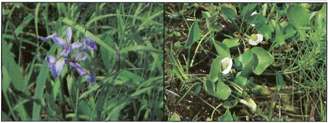
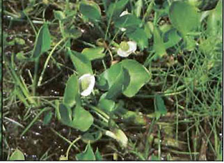
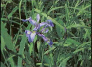
Aquatic (A00) and terrestrial (W02 and W03) flora and fauna were observed during ground visits. Aquatic plants observed included multi-coloured blue flag (Iris versicolor) and water arum (Calla palustris). Numerous large and small mammal tracks were observed within the site and included raccoon, wolf, moose and bear (W02 and W03).
Existing recreational activities include trapping (H06), large mammal hunting (H01) as well as snowmobiling (D10). Two active traplines, Bear Management Areas (BMAs) and baitfish harvest blocks are contained or associated with the site. A provincial snowmobile trail runs along the southern boundary of the site.
Potential recreational activities could include bird watching (ql0), nature study (n05) and ATV riding (t0l). Access to the site can involve concession roads along the western boundary and southeast comer of the conservation reserve and via the railway line; however, access within the interior is limited to the old forest access established within the northern disturbed areas. The presence of marsh and shrub lands - especially the thick alder and willow communities to the south and eastern portions of the conservation reserve currently restricts summer access within the site.
Finally the site’s small size, its donut like
configuration, the presence of extensive marsh and shrub lands and its location within a developed rural community limits the site as a back country recreational destination. However, the lack of forested lands within Site District 4E-5 results in any forested or natural area
to be valued in such a developed landscape. In addition, rehabilitating the cut over areas and possibly some of the shrub lands could increase the site’s recreational potential as well as the site’s representation. Any future planning should consider present recreational values and existing use.
End
C1613- Bryce and Cane Twp. Wetland Lacustrine Conservation Reserve 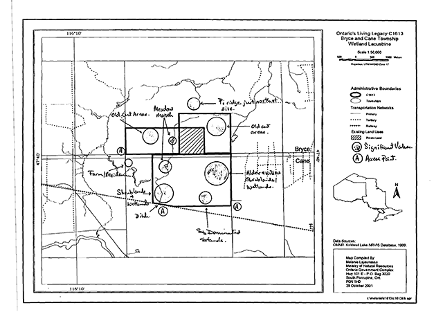
Photos
Appendix #4 Procedural Guideline B- Land Uses- Test of Compatibility (PL Procedure 3.03.05)
The Conservation Reserve policy provides broad direction with regard to the permitted uses. The policy provides only an indication of the variety of uses that will be considered acceptable in Conservation Reserves. The only caution is that any new uses, and commercial activities associated with them, will be considered on a case by case basis, and, they must pass a test of compatibility to be acceptable.
What does a test of compatibility
mean? An examination ofthis must start from the premise of why an area is set aside- specifically, its representative natural heritage values. Criteria are then identified to guide compatibility considerations. These criteria apply to the long-term acceptability of both existing uses and new uses.
- Conformity to SCI/RMP: SCI describes values for which an area has been set aside and the range of appropriate uses that will be permitted in the area. SCI may also speak to the acceptability of other ’new’ uses currently not occurring in the area.
The first test is:do proposed new land uses and/or commercial activities conform to the direction of the SCI/RMP for the Conservation Reserve? Would the new use(s) depart from the spirit of appropriate indicator land uses in the SCI/RMP?
- Impact Assessment: If the proposed use(s) pass test 1 it is important to determine their impact on the area before they are approved. This should include the following:
- Impact on natural heritage values:
will the new use(s) impact any natural values in the area? If so how and to what degree? Is it tolerable?
- Impact on cultural values:
will the new use(s) impact an historical or archaeological values in the area?
- Impact on research activities:
will the new use(s) affect research activities in the area?
- Impact on current uses:
will the new use(s) have any negative impact on the array of current uses?
- Impact on area administration:
will the new use(s) increase administrative cost and/or complexity?
(For example, the cost of area monitoring, security and enforcement). - Impact on accommodating the use outside the Conservation Reserve:
Could the use(s) be accommodated as well or better outside the Conservation Reserve?
- Impact on socio-economics of the area:
will the new use(s) affect the community (ies) surrounding the area in a positive or negative way?
(For example, will the new use make an area less remote thereby affecting a local tourism industry that is dependent on the area’s remoteness for its appeal?) - Impact on area accessibility:
does the new use(s) give someone exclusive rights to the area or a portion of the area to the exclusion of other existing uses?
- Impact on natural heritage values:
Appendix #5 Procedural Guideline C - Research Activities in Conservation Reserves
Purpose
To encourage contributions to the goal of conservation reserves by:
- Providing direction for research activities associated with conservation reserves: and
- Establishing a process for the review and approval of proposals by researchers, which could have an impact on the values protected by the conservation reserve.
Definition
Research means any investigation or study ofthe natural, cultural, social, economic, management or other features of characteristics of conservation reserves.
Guidelines
Research will be encouraged to provide a better understanding of the natural values protected by a conservation reserve and to advance their protection, planning and management. The Statement of Conservation Interest will define, for each conservation reserve, the key research issues, set out the parameters within which research may occur and identify research needs.
Applications and approvals
Researchers must apply in writing to the Area Supervisor for permission to conduct research. The request letter must contain a statement explaining why the proposed research should be undertaken in the particular conservation reserve in preference to another location.
Proposals will be reviewed and approved by the Area Supervisor, guided by the Statement of Conservation Interest prepared for each reserve (see Guideline A- Resource Management Planning) and using Guideline B-Land Uses- Test of Compatibility. Permission must be granted in writing, including any conditions to be met in conducting the research, prior to the undertaking of any research project.
Terms and conditions
Permission to conduct research under this policy will be valid for a period of 12 consecutive months from date of issue. Permission to continue a research project for additional periods of 12 months or less may be granted upon submission of a written request and progress report. The Ministry may require the posting of collateral to assure that the terms and conditions of granting permission are met.
The Area Supervisor may suspend or revoke permission at any time for failure on the part of the researcher to meet:
- The intent or conditions of this policy.
- The requirements under the Public Lands Act, including all amendments, where applicable.
- The requirements under any other Act or Regulations or Ontario or Canada, including those governing the taking, handling, storing, confining, trapping, excavating and marketing any specimen, artifact, information or action (for example, scientific collector’s permit).
- The conditions and agreements specified in granting permission.
Final report
The researcher will submit copies of reports, publications and theses following from the results of the project to the Area Supervisor.
Appendix #6 Indicator uses for Conservation Reserves (In Proposed Bryce and Cane Wetland Lacustrine Conservation Reserve)
Industrial activities
| Activity | Generic OLL policy - existing | Generic OLL Policy - new | Specific application - existing | Specific application - new |
|---|---|---|---|---|
| Commercial timber harvest | No | No | No | No |
|
Cutting of trees by leaseholders and adjacent property owners for fuelwood and small-scale uses |
Maybe | Maybe | No | No |
| Timber salvage/sunken log retrieval | Maybe | Maybe | No | No |
| Mineral exploration | Maybe | Maybe | No | No |
| Mining | No | No | No | No |
| Extraction of peat, soil, aggregate, other materials | No | No | No | No |
| Forest renewal | Maybe |
Maybe |
Maybe |
Maybe |
| Hydro power generation | No | No | No | No |
| Communication corridors | yes | No |
N/A | No |
| Energy transmission corridors | yes | No |
N/A | No |
| Transportation corridors | yes | No |
N/A | No |
| Resource access roads | Maybe |
Maybe |
yes | No |
| Private access roads | yes | No |
yes | No |
Recreation activities
| Activity | Generic OLL policy - existing | Generic OLL Policy - new | Specific application - existing | Specific application - new |
|---|---|---|---|---|
| Sport fishing | yes | yes | yes | yes |
| Sport hunting | yes | yes | yes | yes |
|
Facility development |
Maybe | Maybe | N/A | Maybe |
| Non-trail snowmobiling | Maybe |
Maybe |
N |
N |
| Non-trail ATV use | Maybe |
Maybe |
N |
N |
| Motorized boating | yes | yes | yes | yes |
| Camping | Maybe | Maybe | yes | yes |
| Trails: hiking, snowmobiling, cycling, horse riding and cross-country skiing | yes | Maybe | yes | Maybe |
| Private recreation camps | Yes |
No | N/A | No |
Commercial activities
| Activity | Generic OLL policy - existing | Generic OLL Policy - new | Specific application - existing | Specific application - new |
|---|---|---|---|---|
| Fishing | Yes |
Maybe | N/A | No |
| Bait-fish harvesting | Yes |
Maybe | yes | yes |
| Commercial fur trapping | Yes |
Maybe | yes | yes |
| Trapping cabin | yes | No | yes | No |
| Out-post camps/tourism facilities | Maybe |
Maybe |
N/A | No |
| Commercial bear hunting (tourist operators) | yes | No | yes | N/A |
| Wild rice harvesting | Yes |
Maybe | N/A | No |
| Food harvesting | Maybe | Maybe | N/A | No |
Resource management activities
| Activity | Generic OLL policy - existing | Generic OLL Policy - new | Specific application - existing | Specific application - new |
|---|---|---|---|---|
| Resource inventorying | yes | yes | yes | yes |
| Resource monitoring | yes | yes | yes | yes |
| Fire protection |
yes |
yes | yes | yes |
| Insect and disease | Maybe | Maybe | Maybe | Maybe |
| Featured species management | Maybe | Maybe | Maybe | Maybe |
Other activities
| Activity | Generic OLL policy - existing | Generic OLL Policy - new | Specific application - existing | Specific application - new |
|---|---|---|---|---|
| Research | yes | yes | yes | yes |
| Collecting | Maybe |
Maybe |
Maybe |
Maybe |
| Food gathering | yes | yes | yes | yes |
| Land disposition | Y |
Maybe |
N/A | No |
| Habitat management for wildlife | Maybe |
Maybe |
Maybe | Maybe |
Appendix #7 Maps
Enlarge this map of the area surrounding the conservation area.
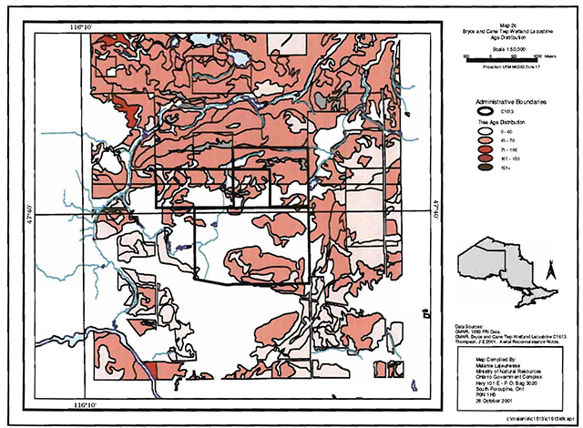
Enlarge this map of Bryce and Cane township administrative boundaries and tree age distribution.
Enlarge this map of Bryce and Cane township administrative boundaries and landforms
Footnotes
- footnote[1] Back to paragraph Gap analysis, in conservation biology terms, is an approach or method for setting and filling natural heritage targets. The process helps identify features that are under-represented within the natural heritage areas system. A number of different approaches can be taken; however, they all try and assess features that may require conservation.
- footnote[2] Back to paragraph Meadow marshes are generally permanently or seasonally flooded wetlands with emergent vegetation covering greater than 25%. Often associated with beaver activity.
- footnote[3] Back to paragraph Fen: Peatland with water table at or above the surface with very slow water movement through communities via seepage that results in a more mineral, nutrient and oxygen- rich environment than bogs. Generally fens contain peat accumulations greater than 40 cm deep. Sometimes occurs as a floating mat with sedges, mosses, shrubs and sparse tree layer present. Indicator plants include; larch (Larix laricina) and eastern white cedar (Thuja occidentalis) over black spruce (Picea mariana), speckled alder (Alnus incana), dwarf birch (Betula pumila), bluejoint grass (Calamagrostis canadensis), assorted sedges, sweet gale (Myrica gale) with ericaceous shrubs present- especially in more nutrient poor fens (Harris et al. 1996)
- footnote[4] Back to paragraph Bog: Peatland with water table at or near the surface with surface often rising above surrounding terrain. Sites are strongly acidic and nutrient poor. Bogs contain peat accumulations of more than 40 cm deep. Species include Sphagnum spp. or Peat Mosses and ericaceous shrubs including bog rosemary (Andromeda glaucophylla), leatherleaf (Chamaedaphne calyculata), creeping snowberry (Gaultheria hispidula), bog laurel (Kalmia polifolia) and Labrador tea (Ledum groenlandicum) (Harris et al. 1996).
- footnote[5] Back to paragraph Provincially significant sites are areas defined by the gap analysis and that, taken together, provide the best representation of the array of landform and vegetation associations known to occur within the Site District 4E-5 (Crins and Kor 1997)
- footnote[6] Back to paragraph In the recently harvested area renewal can be conducted where it will be of net benefit to the protected area and to, the greatest extent possible, it should be designed to replicate natural conditions.
- footnote[7] Back to paragraph The intent is to actively discourage these uses, but it is recognized that in some circumstances these will be no alternative: this will be determined through planning.
- footnote[8] Back to paragraph New private access roads, including additions to existing roads, will not be permitted except where there are previous commitments that were made prior to March 29, 1999. Such commitments will be subject to the completion of a public planning process.
- footnote[10] Back to paragraph Only permitted after test of compatibility and amendment to Statement of Conservation Interest.
- footnote[9] Back to paragraph Use permitted for the direct retrieval of game only.
- footnote[11] Back to paragraph Existing private recreation camps are eligible for enhanced tenure but not for the purchase of lands. A decision to grant enhanced tenure, or to transfer recreational camps will be addressed through a screening process.
- footnote[12] Back to paragraph Existing use permitted to continue, unless there are significant demonstrated conflicts. New operations can be considered, subject to the test of compatibility without an amendment to Statement of Conservation Interest.
- footnote[13] Back to paragraph Existing authorized tourism facilities can continue unless there are demonstrated conflicts. The operators of tourism facilities can apply to upgrade tenure from land use permit (LUP) to lease. New tourism facilities can be considered during planning for a conservation reserve.
- footnote[14] Back to paragraph Sale of lands is not permitted with the exception of some minor types of dispositions where it does not detrimentally affect the values an area is intended to protect. Renewals of existing leases or land use permits are permitted. Requests for transfer of tenure will be considered in the context of the Statement of Conservation Interest. New leases or land use permits will be allowed for approved activities.
- footnote[15] Back to paragraph A specific policy was not identified in the Land Use Strategy, although specific management prescriptions will be identified in the context of an Statement of Conservation Interest.