Clear Lake and Plastic Lake and Dawson Ponds Conservation Reserve Management Statement (2013)
This document provides policy direction for the protection, development and management of Clear Lake and Plastic Lake and Dawson Ponds conservation reserves and their resources.
ISBN 978-1-4606-1581-2 (Print)
ISBN 978-1-4606-1582-9 (PDF)
Approval statement
I am pleased to approve the Clear Lake Conservation Reserve and Plastic Lake and Dawson Ponds Conservation Reserve Management Statement as the official policy for the management and development of these conservation reserves. This plan reflects the Ministry of Natural Resources' intent to protect the natural and cultural features of these conservation reserves, maintain opportunities for high quality traditional outdoor heritage activities for the residents of Ontario and visitors to the Province and provide opportunities for scientific research and monitoring.
This document outlines the policies and implementation priorities for the conservation reserves, details relationships between the conservation reserve values and their associated pressures, and includes a summary of the Aboriginal community, stakeholder and public involvement that occurred as part of the planning process.
The management statement for Clear Lake Conservation Reserve and Plastic Lake and Dawson Ponds Conservation Reserve will be used to guide the management of the conservation reserves over the next 20 years. During that time, the management statement may be reviewed to address changing issues or conditions, and may be amended as the need arises. This management statement will be examined after 20 years in accordance with the provisions of the Provincial Parks and Conservation Reserves Act.
I wish to extend my sincere thanks to all those who participated in the planning process.
Yours truly,
Jane Ireland
A/Regional Director
Southern Region
1. Introduction – A basis for management
Clear Lake Conservation Reserve and Plastic Lake and Dawson Ponds Conservation Reserve are managed according to the purpose, principles and objectives of the Provincial Parks and Conservation Reserves Act, 2006 (PPCRA) and related provincial policies.
This statement provides long term direction for managing the two conservation reserves, including the purpose, vision, permitted uses and implementation priorities. This management statement is written with a 20 year horizon and will be examined after it has been in place for 20 years to determine whether if it is still relevant, effective and current or if adjustments are needed to enable the document to guide the management of the protected area. In circumstances where this statement is not providing sufficient direction to protect the values or address existing or emerging pressures, the statement can be adjusted prior to the next scheduled examination.
Both conservation reserves are addressed in this management statement to achieve planning efficiency as they have common attributes, qualities and characteristics and are within a close geographic proximity sharing similar values and recreational land uses.
2. Location and boundary
2.1 Clear Lake Conservation Reserve
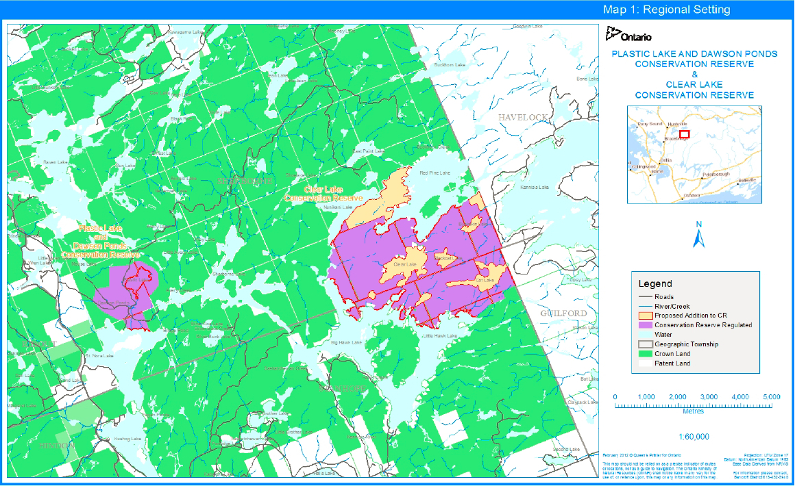
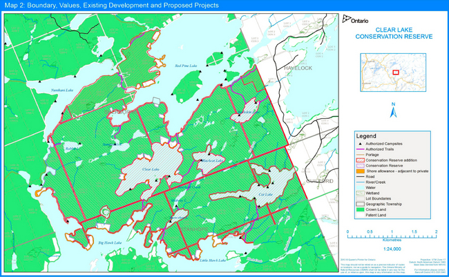
The Clear Lake Conservation Reserve (CR) is located in south-central Ontario, approximately 225 kilometres north of Toronto (Map 1: Regional Setting). This CR lies six kilometres east of Highway 35 and has no direct access from roads. The CR and related water bodies are seasonally accessed by summer and winter outdoor enthusiasts through a series of approved portages/trails. The centres of Minden and Dorset occur on the travel routes leading to the CR.
This 1,307 ha CR occurs entirely in Ecodistrict 5E-9, County of Haliburton, Geographic Townships of Sherborne and Stanhope (Map 1).
This relatively large CR provides a moderate contribution to tourism in the region. At present, it contains 24 campsites that form part of a larger system of campsites and canoe routes currently managed by a partnership of local municipalities called the Haliburton Highlands Water Trails (HHWT), under the authority of a land use permit from the Ontario Ministry of Natural Resources and Forestry (MNRF).
This CR was regulated in 1997 prior to the implementation of the Ontario’s Living Legacy Land Use Strategy.
2.2 Plastic Lake and Dawson Ponds Conservation Reserve
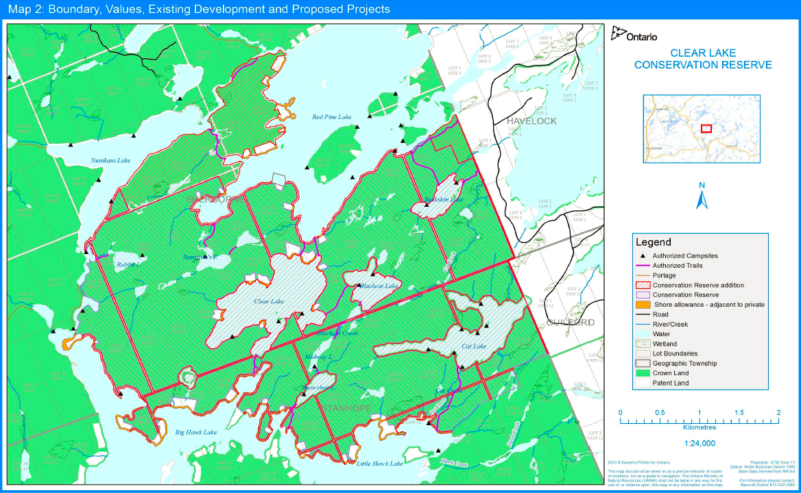
The Plastic Lake and Dawson Ponds CR is located in south-central Ontario, approximately 225 kilometres north of Toronto (Map 1: Regional Setting). This CR lies east of Highway 35, with access from the Sherborne Lake forest access road. The centres of Minden and Dorset occur on the travel routes leading to the CR.
This 200 ha CR occurs entirely in Ecodistrict 5E-9, County of Haliburton, Geographic Township of Sherborne.
This CR provides a small contribution to tourism in the region. The CR currently contains four campsites belonging to the same system of campsites and canoe routes found in the Clear Lake CR and currently managed by HHWT under a land use permit.
The CR was regulated in 2000 as part of the implementation of the Ontario’s Living Legacy Land Use Strategy.
3 Purpose and vision
3.1 Purpose
3.1.1 Clear Lake Conservation Reserve
Clear Lake CR was established to protect its provincially significant representation of old growth eastern hemlock upland forests, mature tolerant hardwood forest and a limnological complex
Today, it is also recognized for its landscape level function, connecting Plastic Lake and Dawson Ponds CR and the Clear Lake – Frost Centre Remote Access Enhanced Management Area (EMA). Significant features of the CR include: a representative pocket of 'sparse coniferous forest on bedrock'; old growth hemlock, red pine, white pine and hard maple forest communities; and structural characteristics of mature/old growth stands. Clear Lake CR also includes important headwater areas, suitable habitat for species at risk, preferred habitat for area sensitive and provincially managed wildlife (white-tailed deer, moose, and black bear), and opportunities for traditional outdoor heritage activities (e.g., hunting, fishing). Its excellent condition as a minimally disturbed protected area and relatively remote character provide additional support for the above values and intact ecological integrity.
3.1.2 Plastic Lake and Dawson Ponds Conservation Reserve
Plastic Lake and Dawson Ponds CR was established to protect Plastic Lake and Dawson Ponds (and their watersheds including headwater areas and related drainage basins) for continued long-term (30 years to date) acid rain research and to protect one of Ontario’s ten richest sites for rare Atlantic Coastal Plain plant communities, including provincially rare species.
Plastic Lake and Dawson Ponds CR also supports upland intolerant/midtolerant forest cover (white pine, red maple and red oak), suitable habitat for SAR, preferred habitat for provincially managed wildlife (white-tailed deer, moose, and black bear) and ongoing opportunities for traditional outdoor heritage activities.
Further information about values is presented in Sections 5 and 6 of this document.
3.2 Vision
3.2.1 Clear Lake Conservation Reserve
The vision for Clear Lake CR is that of a legacy of protection, research and stewardship, ensuring that the remote character of the entire area is conserved.
The protection of the ecological integrity of this area is of the utmost importance. Long-term conservation of natural values in addition to the protection of the entire CR is required for the maintenance of this unique area. Careful management is required to protect the environmentally sensitive aspects of the area and to maintain it for the benefit of future generations.
Diverse low-intensity sustainable recreational and traditional use opportunities will continue to be available. Continued public involvement in the planning and management of this area is essential. Management of the area will respect the existing land use permits and tenure within, and private lands adjacent to the CR.
Protected areas offer many benefits to society. This CR provides the following types of benefits:
- direct use benefits of the protected area are values acquired through direct visitation to the protected area and can include: fishing, hunting, camping, canoeing, trapping, bear management area, baitfish harvest area and land use permits, campsites and canoe routes
- scientific and educational benefits through ongoing ecological research and other potential research opportunities regarding lake trout or palaeoecological studies involving a meromictic lake
- community benefits (locally and regionally) as a tourism destination due to the existence of a managed system of canoe routes and campsites
- ecological services benefits through the protection of head water areas, habitat protection for a wide range of species, potentially including species at risk, and carbon sequestration within the large and intact core forested area
- "non-use"/existence benefits through individual satisfaction or pleasure derived from knowing that protection is being afforded to a unique representative area
footnote 4 and related ecosystems. Such representative areas contribute locally, regionally and to the entire Ontario protected areas (i.e., provincial parks and conservation reserves) system
3.2.2 Plastic Lake and Dawson Ponds Conservation Reserve
The vision for the Plastic Lake and Dawson Ponds CR is that of a legacy of protection, research and stewardship, ensuring that the unique features of these watersheds are conserved.
The protection of the ecological integrity of this area is of the utmost importance. Long-term protection of the unique natural heritage features and values related to research and education are required for the conservation of this unique area. Careful management is required to protect the environmentally sensitive aspects of the area and to maintain it for the benefit of future generations.
Traditional activities including camping, canoeing and hunting will continue to be an integral component of the area. Continued public involvement in the planning and management of this area is essential. Management of the area will respect access considerations (i.e., existing roads) for other users of adjacent Crown lands, the existing land use permit, and other traditional users of the area.
Protected areas offer many benefits to society. This CR provides the following types of benefits:
- direct use benefits through physical contact with the protected area (e.g., hunting, camping, canoeing, trapping, bear management area, baitfish harvesting and existing land use permit [campsites and canoe routes])
- scientific and educational benefits through ongoing involvement in acid rain and other aquatic/hydrological research; additional education benefits afforded through the protection of a rare species/vegetation community
- community benefits (locally and regionally) as a tourism destination due to the existence of a managed system of canoe routes and campsites
- ecological services benefit through watershed protection, habitat protection for a wide range of species including possible and existing species at risk protection of a rare species/vegetation community and carbon sequestration within the protected forest cover
- "non-use"/existence benefits through individual satisfaction or pleasure derived from knowing that protection is being afforded to a unique representative area and related ecosystems.
4. Aboriginal communities
Aboriginal communities located in the vicinity of the two CRs include the following:
- Curve Lake First Nation
- Alderville First Nation
- Chippewas of Rama Mnjikaning First Nation
- Mississaugas of Scugog Island First Nation
- Kawartha Nishnawbe
These Aboriginal communities were provided with opportunities for involvement throughout the planning process, including:
- communicating and providing early and on-going opportunities for involvement
- ensuring communities received a copy of any published documents
- ongoing notification throughout the planning process
Further details on the Aboriginal consultation are provided in Appendix III: Summary of Aboriginal Community, Public and Stakeholder Involvement
5. Permitted uses
5.1 Clear Lake Conservation Reserve
This CR has a variety of permitted recreational and other uses. It is particularly known for:
- back country camping and canoe tripping
- fishing, ice fishing and hunting
- ongoing ecological research and potential for other research
- snowmobiling
- nature education and interpretation
- hunting
- trapping, baitfish harvest area and bear management area
Some existing and potential uses (such as overuse of campsites or trails) may have a negative effect on the natural, cultural or recreational resources of the CR and, as a result, Ontario Parks may restrict specific activities in all or certain portions of the CR. Management actions may be required to minimize negative effects of pressures on values. These issues are considered in Section 6.
Detailed permitted use policies for this CR are presented in Section 6: Stewardship, Operations and Development Priorities and in Appendix I.
5.2 Plastic Lake and Dawson Ponds Conservation Reserve
This CR has a variety of permitted recreational and other uses. It is particularly known for:
- historical and ongoing acid rain research and potential for other aquatic/hydrological research
- nature education and interpretation
- camping and canoeing
- hunting
- trapping, baitfish harvest area and bear management area
Some existing and potential uses may have a negative effect on the natural, cultural or recreational resources of the CR, and as a result, Ontario Parks may restrict specific activities in all or certain portions of the CR. Management actions may be required to minimize negative effects of pressures on values. These issues are considered in Section 6.
Detailed permitted use policies for this CR are presented in Section 6: Stewardship, Operations and Development Priorities and in Appendix I.
6. Stewardship, operations and development priorities
This section presents the detailed site objectives and management actions for the respective CR. As in previous sections, the two CRs will be addressed separately resulting in a unique set of site objectives and management actions for each.
In the following sections, the tables depict the relationship between the values of the CRs, and the pressures exerted on them. Specifically, the tables identify CR values and their current condition, the pressures and challenges affecting them, and associated management actions.
The tracking column is included to emphasize the importance of monitoring the implementation of the proposed actions, evaluating the effectiveness of policies and assessing the efficacy of actions within the management statement. Tracking these items will permit the CR manager to adjust management actions appropriately and may result in changes to the CR management direction.
Implementation of the actions is subject to a number of conditions, including:
- applicable legislation and provincial policy
- A Class Environmental Assessment for Provincial Parks and Conservation Reserves
- availability of financial and human resources
Value condition ranking:
The following ranking
- excellent: no to minimal disturbance
- good: <10% disturbance
- fair: 10-25% disturbance
- poor: >25% disturbance
6.1 Clear Lake Conservation Reserve
6.1.1 Protection: Conserving natural heritage
6.1.1.1 Ecosystem approach to management of Clear Lake Conservation Reserve
Objectives:
- to protect and maintain the overall condition of the CR and ensure abiotic and biotic features and processes are left intact and unimpeded
- monitor, document and benchmark the condition of the protected area over time and adjust actions through an adaptive management approach
footnote 6 (with the available resources)
| Value and Condition | Overall features and communities within the protected area, as well as the suite of representative features and species/habitat assemblages that contribute to the 6.1.1.1 entire protected area system The current condition of this value is fair. |
|---|---|
| Pressures and Challenges | Known pressures are: increased use and increased demand for continued access (either through new, upgraded, or unauthorized trails) resulting in cumulative effects (soil compaction, forest fragmentation, interruption of drainage patterns and damage to vegetation), acid rain, and climate change. Acid rain and climate change are global, national and local in nature and are best addressed collectively through a variety of proposed actions and guidelines. Over time, the pressure from acid rain and related industrial pollution has been reduced; however, because current levels of acid deposition are still beyond the critical limits of many aquatic ecosystems the problem is viewed as increasing. The buffering capacities of soils are also a finite value putting terrestrial vegetative communities at risk over the long term. Climate change continues as a global, national and local problem resulting in extreme weather events (e.g., microbursts, tornadoes), temperature fluctuations, potential species distribution shifts and habitat alterations. This pressure is viewed as increasing. |
| Actions and Guidelines | No new trails permitted. Any trail maintenance requires Ontario Parks approval. All-terrain vehicles (ATVs) and snowmobiles are permitted on authorized trails only except in the direct removal of game. Monitor unauthorized use through partner agencies, conservation officer inspections and other MNRF inspections targeting shoulder seasons. Ensure terrestrial and aquatic native species characteristic of the Ecodistrict 5E-9 and their associated habitats receive protection and long term custodial management. Continue using as a location for ecological research and monitoring. Maintain research opportunities and review every ten years for the potential to serve as a benchmark for larger landscape monitoring of climate change. Facilitate opportunities for future researchers. |
| Tracking Implementation |
| Value and Condition | Protected area boundary The status of this value is viewed as good, as most of the boundary is defined by water systems. |
|---|---|
| Pressures and Challenges | Adjacent land uses – including patent land holdings, LUP holdings, and other adjacent uses (e.g., forestry operations and any other crown land development) Challenge: there are adjacent isolated Crown land parcels (C368a – see Map 2) whose addition to the CR would be beneficial to the protection objective. Challenge: municipal road and shoreline allowances through the protected area are not regulated – with the passing of the PPCRA, these right-of-ways may now be regulated to increase protection. Challenge: potential encroachments by adjacent property owners. |
| Actions and Guidelines | Local MNRF will provide input to adjacent resource management and land use planning (e.g., forest management planning) to identify CR values and ensure concerns and/or negative impacts are considered during the planning process. Regulate Crown parcels and municipal road and shoreline allowances (C368a – see Map 2) as part of the CR. Monitor boundary line infringements as required and take appropriate action. |
| Tracking Implementation |
| Value and Condition | The remote character of the conservation reserve. The current condition of the remote character of the conservation reserve is good. |
|---|---|
| Pressures and Challenges | Increased travel in protected area leading to new and/or upgraded trails (both authorized and unauthorized). Challenge: increased development can result in protected area landscape fragmentation as well as site-specific impacts (e.g., soil compaction, braiding, rutting). With the number of interests in the area - including recreation camps, cottages and campers - development pressure is viewed locally as increasing. |
| Actions and Guidelines | No new trails permitted. ATVs and snowmobiles are permitted on authorized trails only, except in the direct retrieval of game. Signage may be posted at high use locations identifying the permitted uses within the CR. Continue to maintain and protect remoteness of Clear Lake CR through encouraging the use of non-mechanized travel. Inform the public about the significance of the CR and Ontario’s protected area system via internet information, written materials, direct staff contacts, partnership programs, or local tourism information. Monitor unauthorized use through partner agencies, conservation officer inspections and other MNRF inspections targeting shoulder seasons. |
| Tracking Implementation |
| Values and Condition | Pristine waters, including headwater areas of the protected area. The current condition of the value is good. |
|---|---|
| Pressures and Challenges | No known pressure. Challenge: potential for alien aquatic species to be introduced though boating, canoeing, aircraft and fishing activities. The CR is adjacent to waterbodies (Big Hawk, Little Hawk and Red Pine Lakes) with established populations of invasive species (e.g., rusty crayfish and spiny water flea). Through continued spring, summer and fall use of the CR, the potential for introduction is likely increasing. Challenge: potential for nutrient loading from campsites in addition to cottages on private land adjacent to the CR. The use of the campsite/canoe route system has increased over the last five years which means that the potential for nutrient loading is also increasing. Challenge: potential impacts (e.g., temperature change) due to climate change. |
| Actions and Guidelines | As feasible and appropriate, respond to water quality issues that are identified to the CR manager. As the opportunity arises, assess and monitor water quality through partner program areas or agencies (e.g., fisheries inventory and research, MOE, etc.). Education of campers/canoe trippers by partner agencies, and through relationship building with adjacent landowners. Limiting the size of groups using campsites could mitigate potential problems regarding water quality. Monitor for alien species through partner agencies, conservation officer inspections and other MNRF inspections and document in PAPIR Where invasive species threaten natural values, a control program may be undertaken if feasible and practical. |
| Tracking Implementation |
6.1.1.2 Terrestrial and aquatic community and species management of Clear Lake Conservation Reserve
Objectives:
- protect and maintain those features that represent the foundational values of the protected area and/or its contribution to the protected area system and within the broader landscape
- monitor, document and benchmark the condition of values over time and adjust actions through an adaptive management approach (with the available resources)
| Values and Condition | Meromictic lake and related watershed. Current condition of the value is good. |
|---|---|
| Pressures and Challenges | No known pressure. |
| Actions and Guidelines | Local monitoring and/or research opportunity. Locally monitor through temperature readings of the water column to determine the nature of lake stratification. |
| Tracking Implementation |
| Values and Condition | Species at risk – Suitable habitat as identified by Ontario Parks. Confirmed sightings of snapping turtle & Canada warbler (special concern) |
|---|---|
| Pressures and Challenges | No currently known pressures. Challenge: data gap concerning presence and habitat use. Potential conflict with protected area users. Potential for snapping turtle harvest or collection by illegal pet trade. |
| Actions and Guidelines | Potential for habitat assessment based on MNRF's Significant Wildlife Habitat Guidelines and other available tools/protocols as developed or supported by MNR; determine need and seek opportunities to complete inventory via partnerships [e.g., locals, agencies, NHIC Education to minimize human conflict via partner agencies as required. Conservation officers will continue to monitor and enforce SAR collection / trafficking. Visual observations of SAR by staff will be recorded. |
| Tracking Implementation |
| Values and Condition | Cold water fishery.
|
|---|---|
| Pressures and Challenges | Currently no documented pressures. Challenge: potential for introduction of alien aquatic species to the cold water fishery and related water systems though boating, canoeing, aircraft and fishing activities. The CR is adjacent to waterbodies (Big Hawk, Little Hawk and Red Pine Lakes) with established populations of invasive species (e.g., rusty crayfish and spiny water flea). Through continued spring, summer and fall use of the CR, the potential for introduction is likely increasing. Challenge: potential for nutrient loading from campsites in addition to cottages on private land adjacent to the CR. The continued use of the campsite/canoe route system over the last five years means that the pressure from nutrient loading will continue to be present. Challenge: potential impacts (e.g., temperature change) due to climate change. |
| Actions and Guidelines | Education of cottagers and CR users via internet information, written materials, direct staff contacts, partnership programs, or local tourism information exchange on precautionary measures and importance of avoiding the introduction of alien aquatic species, and the impact of nutrient loading from various sources. Monitor invasive species, temperature changes and species assemblage shifts based on current partnerships/research in the CR. CR manager to seek out opportunities for research into invasive species or climate change indicators. Potential for sustainability issues will be monitored through broad-scale monitoring and creel census. As feasible and appropriate, respond to water quality issues that are identified to the CR manager. Where invasive species threaten natural values, eradication or a control program may be undertaken if feasible and practical. |
| Tracking Implementation |
| Values and Condition | Wetland ecosystems (e.g., ephemeral pools Due to a number of portages that are in low, wet points on the landscape, the current condition of this value is fair. |
|---|---|
| Pressures and Challenges | Current human use of trails and portages that cross wetland ecosystems. Challenge: disruption to vegetation, localized drainage patterns and soils (e.g., compaction) and overall deterioration of the local feature at points where existing portages/trails cross wetlands. The pressure is increasing as the use of the area for camping and canoe tripping increases. |
| Actions and Guidelines | Evaluation of the existing portage/trail locations that are part of partner agencies campsite network. Where required, rehabilitate if possible and/or construct mitigating structures using appropriate construction methods (e.g., foot bridge). Construction by partner agencies will require Ontario Parks authorization. Monitoring by partner agencies during regular inspections could involve developing a database of locations and structures with GPS locations, photo documentation and record of condition with date of inspection. |
| Tracking Implementation |
| Values and Condition | Steep cliff ecosystem – west facing cliffs with marble outcrops (locally uncommon and potential habitat for calciphiles |
|---|---|
| Pressures and Challenges | No known pressures. |
| Actions and Guidelines | Seek out opportunities for inventory of steep cliff ecosystem species. Rock-climbing and ice climbing are not permitted. |
| Tracking Implementation |
6.1.2 Sustainable land use activities/traditional outdoor heritage activities
6.1.2.1 Operations and development for Clear Lake Conservation Reserve
Objectives:
- maintain existing campsites, day use sites and portages/trails, while monitoring and managing such use so that related activities are ecologically sustainable and compatible with the protection of other CR values
- ensure land uses including traditional outdoor heritage activities and recreational activities are ecologically sustainable by monitoring and managing such activities with the resources available
| Values and Condition | Commercial resource harvesting opportunities (e.g., bear management areas, registered trap lines and commercial baitfish licenses). |
|---|---|
| Pressures and Challenges | No known current pressures. Challenge: negative public perception and perception of activities occurring in an unsustainable manner. Potential for sustainability issues. Challenge: potential for introduction of invasive species. |
| Actions and Guidelines | The two bear management areas (MD 45-003), one registered trap line (MD-002) and two baitfish licences (baitfish blocks 82 & 84) will be permitted to continue. CR staff will work with district fish and wildlife staff to ensure annual reporting and assessment to address sustainability of resources and any other issues if required. As feasible and appropriate, respond to commercial resource harvesting issues that are identified to the CR manager. |
| Tracking Implementation |
| Values and Condition | Portages/trails – access for traditional outdoor heritage activities. Designated day use and overnight camp sites The condition of these is viewed as good. |
|---|---|
| Pressures and Challenges | Increased use. The pressure on these values and the local environment include heavy localized use of the campsite system by the public (campers/canoe trippers and the general public), resulting in trampling and soil compaction. The pressure can be viewed as locally increasing (depending on area) as camper numbers have increased over the last five years. Challenge: to provide good quality campsites, portages and trails in order to a) provide a high quality recreational experience, b) protect surrounding landscape from trampling, soil compaction, trail braiding, campsite deterioration (including human faecal contamination). |
| Actions and Guidelines | No new trails permitted. Monitor and document use of and ecological impacts from authorized trails through partner agencies, and explore opportunities to close, rehabilitate or improve impacted campsites and portage/trail segments as needed. Any trail maintenance requires Ontario Parks approval. Update and maintain an ongoing authorized portage/trail map and authorized campsite map in conjunction with partner agencies and internally with Land Information Ontario (LIO). Limiting the size of groups using campsites could reduce effects of heavy use on the campsites. |
| Tracking Implementation |
| Values and Condition | Special access privilege 1/ Boat caches – public 2/ Boat caches- Clear Lake property owners |
|---|---|
| Pressures and Challenges | Challenge: public boat caches result in extra fishing pressure during the open water fishing season. Boat caches can also jeopardize the feeling of remoteness or the backcountry experience sought after by canoe trippers and campers. Challenge: Caching of boats by the Clear Lake property owners have resulted in multiple boats being cached at access points, creating crowding as well as aesthetic issues for other users (campers/canoe trippers). Challenge: increased boat caches can impact local heritage features – the number and location need to be addressed |
| Actions and Guidelines | Public boat caches are not permitted within the CR. Boat caches - Clear Lake property owners: Limit the number of cached boats to two per Clear Lake property owner within the CR. Boats can only be cached at designated locations. Ontario Parks to establish a contact with the cottage owners group. A permitting system will be implemented: Year One (within one year of management direction release): Clear Lake property owners will be required to display a boat cache decal, as issued by Ontario Parks, on up to two cached boats. Year Two (within two years of management direction release): Any boats found within the CR without an affixed authorized boat cache decal will be removed. Ontario Parks will identify the location of cached boats, establish designated boat cache areas for Clear Lake property owners, and monitor their condition. |
| Tracking Implementation |
| Values and Condition | Hunting and fishing opportunities |
|---|---|
| Pressures and Challenges | No known current pressures. Negative public perceptions concerning activities and sustainability. Potential for introduction of invasive species through use of bait fish. Potential for sustainability issues. |
| Actions and Guidelines | Hunting and fishing are permitted as per the Fish and Wildlife Conservation Act. Enforcement will be used as required. Native fish stocking is permitted, except on Clear Lake. Ontario Parks authorization is required. Education of cottagers and CR users on importance of avoiding the introduction of alien aquatic species. |
| Tracking Implementation |
| Values and Condition | Historical travel route for voyageurs and Aboriginal peoples that is currently used as a portage Current condition is good. |
|---|---|
| Pressures and Challenges | No documented pressures. Challenge: there is the potential for pressures on the aesthetic or "natural" value of the travel route through the over-use of signage or other developments. The pressure on this value is likely to remain the same over time. |
| Actions and Guidelines | As a condition of the land use permit for the canoe route system, ensure the aesthetic appearance of the portage/travel route is maintained (e.g., limit the number and placement of signs, location of any future development and boat caches etc.) Monitor the appearance and use of the route through photo documentation over time (e.g., every three to five years). |
| Tracking Implementation |
6.1.3 Research, inventory and monitoring
Objectives:
- provide for the continuation of existing research and monitoring activities that are currently underway in the CR, specifically the long term benchmarking of acid rain research by the Ministry of the Environment in Clear Lake
- continue to encourage and make available other research opportunities in support of the objectives of the parks and protected areas system. New research opportunities must be consistent with the PPCRA and associated regulations, and require authorization issued under the Research Authorization Policy for Provincial Parks and Conservation Reserves
6.1.4 Community partnerships
Objectives:
- maintain open communication with existing partner agencies to facilitate and encourage the sustainable use and management of the network of canoe routes, campsites and related resources for the enjoyment of the Ontario public
- continue to encourage and make available other partnership opportunities in support of the objectives of the parks and protected areas system. Partnership activities must adhere to relevant conditions and permissions contained in any permitting or agreement documentation
6.2 Plastic Lake and Dawson Ponds Conservation Reserve
6.2.1 Protection: Conserving natural heritage
6.2.1.1 Ecosystem approach to protected area management of the Plastic Lake and Dawson Ponds CR
Objectives:
- to protect and maintain, as an entire protected area, the overall condition and to ensure both abiotic and biotic features and processes for their natural regions are left intact and unimpeded now and for future generations
- monitor, document and benchmark the condition of the protected area over time and adjust actions through an adaptive management approach (with the available resources)
| Values and Condition | Research site that has been used for over 30 years of research in the watershed and drainage areas (and used in about 400 research papers to date). Much of this research has been conducted in Plastic Lake and Dawson Ponds. Current state of the value is good. |
|---|---|
| Pressures and Challenges | Challenge: potential changes to water chemistry and water quality due to upgrade and maintenance of the Sherborne forest access road. The potential for this to occur will increase over the next 10 years as forest operations may require the upgrade and maintenance of the road through the CR. Potential changes to water chemistry and quality may occur in response to nutrient loading from local campsites within the boundary of the Plastic Lake and Dawson Ponds CR. |
| Actions and Guidelines | Applications for road maintenance and upgrades will be considered on a case-by-case basis, subject to Ontario Parks review and approval. To mitigate/minimize potential changes to water chemistry and water quality, there will be no use of calcareous material permitted in road upgrade/maintenance. Alteration or enhancement of fish habitat and fish stocking are not permitted due to the importance of the watershed and resident fish community as a benchmark in existing research. Education of campers and limiting the size of groups using campsites to mitigate potential problems regarding water quality. Education will involve partner agencies. |
| Tracking Implementation |
| Values and Condition | Headwater areas to cold water systems. The current condition of this value is viewed as good. |
|---|---|
| Pressures and Challenges | Pressure on water quality from existing developments (Moose Lake Road, Sherborne forest access road and campsites). This pressure is viewed as having the potential to increase over the next 10 years with increased activity from forest management operations and camper use activities. |
| Actions and Guidelines | Education of campers and limiting the size of groups using campsites to mitigate potential problems regarding water quality. Education will involve partner agencies. Applications for road maintenance and upgrades will be considered on a case-by-case basis, subject to Ontario Parks review and approval. To mitigate/minimize potential changes to water chemistry and water quality. There will be no use of calcareous material permitted in road upgrade/maintenance. |
| Tracking Implementation |
6.2.2 Sustainable land use activities/traditional outdoor heritage activities
6.2.2.1 Operations and development for Plastic Lake and Dawson Ponds CR
Objectives:
- maintain existing campsites, day use sites and portages/trails, while monitoring and managing such use so that related activities are ecologically sustainable and compatible with the protection of other CR values
- ensure land uses including traditional outdoor heritage activities and recreational activities are ecologically sustainable by monitoring and managing such activities with the resources available
| Values and Condition | Commercial resource harvesting opportunities (e.g., bear management areas, registered trap lines, and commercial baitfish licenses) |
|---|---|
| Pressures and Challenges | No known current pressures. Challenge: negative public perception and perception that activities may be occurring in an unsustainable manner. Potential for sustainability issues. Challenge: potential for introduction of invasive species |
| Actions and Guidelines | The bear management area (MD 45-003), the registered trap line (MD-3) and two baitfish licenses (baitfish blocks 82 & 84) will be permitted to continue; Ontario Parks will work with MNRF district fish and wildlife staff to ensure annual reporting and MNRF assessment to address any sustainability or other issues if required. As feasible and appropriate, respond to commercial resource harvesting issues that are identified to the CR manager. |
| Tracking Implementation |
| Values and Condition | Portages/trails – access for traditional outdoor heritage activities. Designated day use and overnight camp sites. The condition of these is viewed as good. |
|---|---|
| Pressures and Challenges | The pressure on these values and the local environment include trampling and soil compaction through heavy localized use of the campsite system by the public (campers/canoe trippers and the general public). The pressure can be viewed as locally increasing (depending on area) as camper numbers have increased over the last five years (see the Background Information File). Challenge: to provide good quality campsites, portages and trails in order to a) provide a high quality recreational experience, b) protect surrounding landscape from trampling, soil compaction, trail braiding, campsite deterioration (including human faecal contamination). |
| Actions and Guidelines | No new trails permitted. Monitor/document use and ecological impacts from authorized trails through partner agencies, and explore opportunities to close, rehabilitate or improve impacted campsites and portage/trail segments as needed. Update and maintain an ongoing authorized portage/trail map and authorized campsite map in conjunction with partner agencies and internally with LIO (Land Information Ontario). |
| Tracking Implementation |
| Values and Condition | Hunting and fishing opportunities. |
|---|---|
| Pressures and Challenges | No known current pressures. Challenge: negative public perceptions concerning activities and sustainability. Challenge: potential for introduction of invasive species with bait fish use. Potential for sustainability issues. |
| Actions and Guidelines | Enforcement will be used as required. Education of cottagers and CR users on importance of avoiding the introduction of alien aquatic species. Alteration or enhancement of fish habitat and fish stocking are prohibited due to the importance of the watershed and resident fish community as a benchmark in existing research. |
| Tracking Implementation |
6.2.3 Research, inventory and monitoring
Objectives:
- encourage the continuation of existing research and monitoring activities that are currently underway in the CR, specifically the long term benchmarking of acid rain research by the Ministry of the Environment in Plastic Lake and Dawson Ponds
- continue to encourage and make available other research opportunities in support of the objectives of the parks and protected areas system. New research opportunities must be consistent with the PPCRA and associated regulations, and require authorization issued under the Research Authorization Policy for Provincial Parks and Conservation Reserves
6.2.4 Community partnerships
Objectives:
- maintain open communication with partner agencies to facilitate and encourage the sustainable use and management of the network of canoe routes, campsites and related resources for the enjoyment of the Ontario public
- continue to encourage and make available other partnership opportunities in support of the objectives of Clear Lake CR and Plastic Lake and Dawson Ponds CR. Partnership activities must adhere to relevant conditions and permissions contained in any permitting or agreement documentation
7. Implementation priorities
Implementation of development, operations and resource management for Clear Lake CR and Plastic Lake and Dawson Ponds CR will be contingent upon the availability of funding and unforeseeable changes in priorities or policy. Implementation of the management statement will meet the requirements of the PPCRA, Environmental Assessment Act, EBR, ESA 2007, and other pertinent legislation.
Priorities will include:
- complete the land use amendment to include the proposed additions, the unopened municipal road allowances and the shoreline road allowances into the CRs
- identify the location of cached boats and implement the boat cache authorizations system for property owners on Clear Lake
- continue to authorize the Land Use Permit (LUP) for the operation and maintenance of the network of campsites and portages throughout the CRs
- continue to authorize research on acid rain in Plastic Lake and Dawson Ponds CR, and provide ongoing opportunities for research on the life science, earth science and cultural heritage values associated with the CRs
- monitor and evaluate existing recreational use levels and impacts as required to ensure conservation reserve values are not being adversely impacted
8. References
Ministry of Natural Resources. 1997. Conservation Reserve Policy.
Ministry of Natural Resources. 1999. Ontario’s Living Legacy Land Use Strategy. [online] URL: http://www.mnr.gov.on.ca/en/Business/LUEPS/2ColumnSubPage/STDU_137970.html (link no longer active)
Ministry of Natural Resources. 2005. A Class Environmental Assessment for Provincial Parks and Conservation Reserves. Environmental Assessment Report Series. Queen’s Printer for Ontario. 120 pp.
Ministry of Natural Resources. 2007. Crown Land Use Policy Atlas. [online] URL: http://www.ontario.ca/page/crown-land-use-policy-atlas
Ministry of Natural Resources. 2009. Determining Planning and Management Priorities in the Context of Ecological Integrity, A Practical Approach for Planning Teams. [online] URL: http://www.ontarioparks.com/english/planning_pdf/plan-manual-1992.pdf (link no longer active)
Ministry of Natural Resources. 2009. Ontario Protected Areas Planning Manual.Queen’s Printer for Ontario. 50 pp. [online] URL: https://www.ontario.ca/page/ontarios-protected-areas-planning-manual
Ministry of Natural Resources. 2011. Our Sustainable Future: A Renewed Call to Action - Ministry of Natural Resources Strategic Directions. Deputy Minister’s Office. Toronto. 24 pp. [online] URL: http://mnronline.mnr.gov.on.ca/Document/View.asp?Document_ID=19058&Att (link no longer active)
Ontario. S.O.2006. Provincial Parks and Conservation Reserves Act, 2006 [online] URL: http://www.e- laws.gov.on.ca/html/statutes/english/elaws_statutes_06p12_e.htm.
Appendix I: Protected area permitted uses table
This appendix presents the policies and guidelines that pertain to the variety of uses and activities that occur, or that may arise in the future for the Clear Lake Conservation Reserve (CLCR) and the Plastic Lake and Dawson Ponds Conservation Reserve (PLDPCR).
Activity/Management Themes column lists broad activities and management themes with specific sub themes as appropriate – note that there may be different approaches for existing and new activities.
Permitted column provides codes applicable to the CR for each activity or broad theme/sub theme – yes/no/maybe or not applicable, see below.
Legislation, Policies, Guidelines and Additional Information column provides the source of direction (e.g., a secondary plan) where this exists or can be used to indicate if something is being developed. It also clarifies the application of provincial policy by identifying applicable local information (e.g., number of management units such as traplines, bear management areas).
Clear Lake CR and Plastic Lake and Dawson Ponds CR will be managed in accordance with the following:
- Provincial Parks and Conservation Reserves Act, 2006 (PPCRA)
- other pertinent legislation (e.g., Endangered Species Act, 2007)
- A Class Environmental Assessment for Provincial Parks and Conservation Reserves (Class EA-PPCR), 2005
- the site specific direction contained in this management statement
Due to the fact that Clear Lake CR was regulated prior to the Ontario Living Legacy Land Use Strategy, pre-existing policies for conservation reserves apply.
Plastic Lake and Dawson Ponds CR was regulated as part of the Ontario Living Legacy Land Use Strategy (OLL), therefore OLL and associated policies apply.
| Area ID: | C368 as per Crown Land Use Policy Atlas |
|---|---|
| Area Name: | Clear Lake Conservation Reserve |
| Size (ha): | 1307.0 |
| Designation: | Conservation Reserve |
| MNRF District(s): | Bancroft District |
| Area ID: | C69 as per Crown Land Use Policy Atlas |
| Area Name: | Plastic Lake and Dawson Ponds Conservation Reserve |
| Size (ha): | 200.00 |
| Designation: | Conservation Reserve |
| MNRF District(s) | Bancroft District |
'Permitted' Column Codes:
Yes = Permitted in this protected area, subject to any limitations noted.
No = Not permitted in this area, subject to any exceptions noted.
Maybe = may be applicable in this protected area.
Industrial
| Activity/Management Theme | Permitted in Clear Lake CR | Permitted in Plastic Lake and Dawson PondsCR | Legislation, Policies, Guidelines and Additional Information |
|---|---|---|---|
| Commercial timber harvesting | No | No | PPCRA Section 16(1) |
| Aggregate, topsoil and peat extraction | No | No | PPCRA S. 16; see S. 19 for exceptions |
| Prospecting, staking mining claims, developing mineral interests or working mines | No | No | PPCRA S. 16; see S. 18 (2) and (3) for exceptions |
Fisheries
| Activity/Management Theme | Permitted in Clear Lake CR | Permitted in Plastic Lake and Dawson PondsCR | Legislation, Policies, Guidelines and Additional Information |
|---|---|---|---|
| Sport fishing | Yes | Yes | Subject to the Fish and Wildlife Conservation Act, 1997 and Ontario Recreational Fishing Regulations Summary. |
| Commercial fishing Existing | No | No | |
| Commercial fishing Existing | No | No | |
| Commercial bait fishing Existing | Yes | Yes | Existing use is permitted. Two commercial baitfish licences (baitfish blocks 82 & 84) exist within and adjacent to both CRs. An existing authorized bait harvesting licence may be transferred, subject to review and approval by the MNRF and following established allocation procedures. |
| Commercial bait fishing New | No | No | No new bait harvesting licences will be permitted in the CRs. |
| Stocking Native species | Maybe | No | CLCR: Native fish stocking is permitted with Ontario Parks authorization in all lakes except Clear Lake. Ongoing stocking of Brook Trout in Rabbit Lake, Blackcat Lake and Cat Lake will be permitted to continue. Refer to Guidelines for Stocking Fish in Inland Waters of Ontario, 2002. Strategic Plan for Ontario Fisheries, 1992. Leslie M. Frost Natural Resource Centre Fisheries Management Plan, 1986-2000. PLDPCR: Stocking the waters of Plastic Lake is not permitted based on the importance of the watershed to acid rain research and importance of the resident fish community as a benchmark in existing research. |
| Stocking Non-native species | Maybe | No | Established ongoing put-grow-take stocking programs of non-native cold water species (i.e., Splake) by MNRF will be permitted to continue in Clear Lake CR in Sampson Pond and Buckskin Lake, in accordance with the Bancroft District Fisheries Management Plan, as subject to review. Other non-native species will not be deliberately introduced via stocking in both CRs consistent with the PPCRA. |
| Fish habitat management | Yes | No | CLCR: Refer to Strategic Plan for Ontario Fisheries, 1992. Leslie M. Frost Natural Resource Centre Fisheries Management Plan, 1986-2000. PLDPCR: Alteration or enhancement of fish habitat is not permitted in Plastic Lake based on the importance of the watershed to acid rain research and importance of the resident fish community as a benchmark in existing research. Any alteration or enhancement to fish habitat must meet requirements of federal legislation. |
Wildlife
| Activity/Management Theme | Permitted in Clear Lake CR | Permitted in Plastic Lake and Dawson Ponds CR | Legislation, Policies, Guidelines and Additional Information |
|---|---|---|---|
| Hunting | Yes | Yes | Subject to the Fish and Wildlife Conservation Act, 1997 and Ontario Hunting Regulations Summary. |
| Commercial fur harvesting Existing | Yes | Yes | Active registered trap lines occur within and adjacent to each of the CRs (MD-002 in Clear Lake CR and MD3 in Plastic Lake and Dawson Ponds CR) Existing use is permitted to continue, provided that it does not impact reserve values. An existing authorized trap line may be renewed or transferred, if approved by MNRF. Reallocation of a trap line may occur following appropriate screening where licences have lapsed, been revoked or surrendered. |
| Commercial fur harvesting New | No | No | New commercial fur harvesting operations will not be permitted in the CRs. |
| Bear management areas Existing | Yes | Yes | Both CRs are within an Active Bear Management Area (MD- 54-003). Existing use is permitted to continue. An existing authorized BMA licence may be renewed or transferred, if approved by MNRF. Reallocation of a BMA licence may occur following appropriate screening where licences have lapsed, been revoked or surrendered. |
| Bear management areas New | No | No | New BMA licences will not be issued for CRs. |
| Wildlife habitat management | Yes | Yes | Leslie M. Frost Natural Resources Centre Integrated Plan for Land Use and Resource Development, 1980. |
Forest fire management
Will be consistent with the Forest Fire Management Strategy for Ontario and the Fire Management Policy for Provincial Parks and Conservation Reserves. Purposes of fire management: 1) protect human life, property and other values; and, 2) use fire for ecological benefits & to reduce hazards. Fires that threaten human life, property or values will receive a response commensurate with the risk to prevent harmful effects & minimize disruption of socio-economic activities. Use of fire to achieve ecological benefits or reduce fire hazards will be identified in accordance with the Fire Management Planning Guidelines for Provincial Parks and Conservation Reserves & other applicable policies and guidance in Section 6. Minimum impact suppression techniques will be used where feasible & practical to reduce the effects on values.
| Activity/Management Theme | Permitted in Clear Lake CR | Permitted in Plastic Lake and Dawson Ponds CR | Legislation, Policies, Guidelines and Additional Information |
|---|---|---|---|
| Response and suppression | Yes | Yes | The Clear Lake CR and the Plastic Lake and Dawson Ponds CR are located within the Great Lakes - St. Lawrence fire management zone and are subject to the response outlined below. Aviation, Forest Fire Management and Emergency Services of the Ontario Ministry of Natural Resources is the lead agency responsible for response and protection. Located in Southern Region and the Great Lakes – St. Lawrence fire management zone the Clear Lake CR and the Plastic Lake and Dawson Ponds CR areas would be subject to full response and fire suppression as per Section 3.0 of Fire Management Planning Guidelines for Provincial Parks and Conservation Reserves. |
| Prescribed burning | Yes | Yes |
Vegetation
Insects and disease control
| Activity/Management Theme | Permitted in Clear Lake CR | Permitted in Plastic Lake and Dawson Ponds CR | Legislation, Policies, Guidelines and Additional Information |
|---|---|---|---|
| Native species | No | No | |
| Non-native species | Yes | Yes | (See Alien and Invasive Species Control) |
Non-timber vegetation products
| Activity/Management Theme | Permitted in Clear Lake CR | Permitted in Plastic Lake and Dawson Ponds CR | Legislation, Policies, Guidelines and Additional Information |
|---|---|---|---|
| Wild rice harvesting Existing | No | No | There are no known operators currently engaged in the commercial harvest of wild rice within the boundaries of the Clear Lake CR or the Plastic Lake and Dawson Ponds CR. |
| Wild rice harvesting New | No | No | There are no known operators currently engaged in the commercial harvest of wild rice within the boundaries of the Clear Lake CR or the Plastic Lake and Dawson Ponds CR. |
| Blueberry harvesting Commercial | No | No | There are no known operators currently engaged in the commercial harvest of wild rice within the boundaries of the Clear Lake CR or the Plastic Lake and Dawson Ponds CR. |
| Blueberry harvesting Personal | Yes | Yes | There are no known operators currently engaged in the commercial harvest of wild rice within the boundaries of the Clear Lake CR or the Plastic Lake and Dawson Ponds CR. |
| Canada yew Commercial | No | No | Harvesting would be too disruptive of vegetation and soils to allow it. |
Vegetation management
| Activity/Management Theme | Permitted in Clear Lake CR | Permitted in Plastic Lake and Dawson Ponds CR | Legislation, Policies, Guidelines and Additional Information |
|---|---|---|---|
| Silviculture (plantations, old growth) | No | No | |
| Aesthetics (e.g., maintain vistas) | No | No | |
| Intensive use areas (e.g., day use areas, campgrounds) | No | No |
Species at risk (SAR)
The Clear Lake CR and Plastic Lake and Dawson Ponds CR are generally within the range and possess suitable habitat for a number of species at risk, including, but not limited to: Blanding’s Turtle, Five-lined Skink, Eastern Hog-nosed Snake and Whip-poor-will. As appropriate, activities will reflect recovery strategies, government response statements and habitat regulations from those plans to integrate protected areas' resource stewardship with broader landscape strategies. If possible, monitoring efforts will be undertaken to further confirm SAR presence / absence and related habitat. Refer to Endangered Species Act (ESA) and Regulations and PPCRA Section 5 (3).
| Activity/Management Theme | Permitted in Clear Lake CR | Permitted in Plastic Lake and Dawson Ponds CR | Legislation, Policies, Guidelines and Additional Information |
|---|---|---|---|
| Maintenance | Yes | Yes | As species presence is confirmed, evaluate what actions are needed to maintain and protect populations and habitat based on the government response statement, habitat regulations and recovery strategy. |
| Restoration | Yes | Yes | As species presence is confirmed, evaluate what actions are needed to maintain and protect populations and habitat based on the government response statement, habitat regulations and recovery strategy. |
Alien and invasive species control
Alien species are species of plants, animals and micro-organisms that have been accidentally or deliberately introduced into areas beyond their normal range. Invasive species are those alien species whose introduction or spread threatens the environment, the economy and/or society, including human health.
| Activity/Management Theme | Permitted in Clear Lake CR | Permitted in Plastic Lake and Dawson Ponds CR | Legislation, Policies, Guidelines and Additional Information |
|---|---|---|---|
| Alien & invasive | Yes | Yes | Alien and invasive species will not be deliberately introduced. Education of cottagers and CR users via internet information, written materials, direct staff contacts, partnership programs, or local tourism information exchange on precautionary measures and importance of avoiding the introduction of alien aquatic species. CLCR: Clear Lake CR is adjacent to water bodies (Big Hawk, Little Hawk & Red Pine Lakes) with populations of invasive species (e.g., rusty crayfish and the spiny water flea). Management activities in CLCR will reflect policy/ strategies to prevent the introduction and spread of invasive species and the eradication and control of established populations. PLDPCR: The Plastic Lake and Dawson Ponds CR contains Plastic Lake. This water body has an established population of an invasive species (i.e., rainbow smelt). Management activities in PLDPCR will reflect policy/strategies to remove/stop the spread of alien and invasive species and the eradication and control of established populations. |
Water
| Activity/Management Theme | Permitted in Clear Lake CR | Permitted in Plastic Lake and Dawson Ponds CR | Legislation, Policies, Guidelines and Additional Information |
|---|---|---|---|
| Water control structure Existing | No | No | |
| Water control structure New | No | No |
Lands
| Activity/Management Theme | Permitted in Clear Lake CR | Permitted in Plastic Lake and Dawson Ponds CR | Legislation, Policies, Guidelines and Additional Information |
|---|---|---|---|
| Crown land disposition Existing private LUP | Yes | Yes | Sale of lands is not permitted. Renewals of existing leases or LUPs are permitted. Requests for transfer of tenure will be considered in the context of the PPCRA. |
| Crown land disposition Existing commercial LUP | Yes | Yes | One commercial LUP exists within the bounds of both CRs authorizing the management of a network of campsites and canoe routes by a partner agency. |
| Crown land disposition New private LUP | No | No | New commercial LUPs may be permitted for approved activities that are evaluated through a "Protected Area Compatibility Test". |
| Crown land disposition new commercial LUP | Maybe | Maybe | |
| Crown land permits Personal use permits for wood harvesting Existing | No | No | No existing fuel wood permits have been issued for the CRs. |
| Crown land permits Personal use permits for wood harvesting New | No | No | Not permitted. |
| Trap cabins Existing | No | No | No existing trap cabins present in the CRs. |
| Trap cabins New | No | No | New cabins on existing trap lines will not be permitted in the CRs. |
Utility corridors
| Activity/Management Theme | Permitted in Clear Lake CR | Permitted in Plastic Lake and Dawson Ponds CR | Legislation, Policies, Guidelines and Additional Information |
|---|---|---|---|
| Energy transmission and communications corridors Existing | No | No | N/A |
| Energy transmission and communications corridors New | Maybe | Maybe | As per PPCRA S. 21, proposals for new facilities should avoid CRs where possible. |
Roads and trails
| Activity/Management Theme | Permitted in Clear Lake CR | Permitted in Plastic Lake and Dawson Ponds CR | Legislation, Policies, Guidelines and Additional Information |
|---|---|---|---|
| Trails Existing | Yes | Yes | Authorized trails include only those existing trails as determined by Ontario Parks to be part of the portage network. Refer to Recreation Activities and Facilities section (page 46) for specific use and guideline information. Any trail maintenance requires Ontario Parks approval. |
| Trails New | No | No | No new trails permitted. |
| Roads Existing | No | Yes | PLDPCR: As per policy & PPCRA (s.20), the existing, authorized roads for forest management /recreation purposes and Crown land access (the Sherborne Road and the Moose Lake Road) will continue. Continued use will include maintenance and may include future upgrading within the roads existing footprint. Ontario Parks staff will review new proposals for maintenance or upgrade of the Sherborne or Moose Lake Road(s). The result of such reviews will be the development of comments/ conditions to mitigate damage to the rare Atlantic Coastal Plain vegetative community, potential changes to water chemistry and water quality. There will be no use of calcareous aggregate material permitted in road upgrade/maintenance within the CR. |
| Roads New | No | No | No new trails permitted. |
Science and education
| Activity/Management Theme | Permitted in Clear Lake CR | Permitted in Plastic Lake and Dawson Ponds CR | Legislation, Policies, Guidelines and Additional Information |
|---|---|---|---|
| Education programs Existing | Yes | Yes | |
| Education programs New | Yes | Yes | |
| Historical appreciation: Self guided | Yes | Yes | |
| Nature appreciation: Self | Yes | Yes | |
| Research | Yes | Yes | Maintain the existing partnership with the Ministry of the Environment for ongoing acid rain research. Encourage new research partnership opportunities to support the conservation of CR values and evaluate new research proposals through the application of the Research Authorization Policy for Provincial Parks and Conservation Reserves. |
Commercial tourism, facilities, and operations
| Activity/Management Theme | Permitted in Clear Lake CR | Permitted in Plastic Lake and Dawson Ponds CR | Legislation, Policies, Guidelines and Additional Information |
|---|---|---|---|
| Outfitting services, outpost camps, resorts/lodges, trails, access points, restaurants, concessions: Existing | Yes | Yes | Existing activities (trails, campsites, access points) permitted as per current Land Use Permit. Refer to Recreation Activities and Facilities section for specific use and guideline information. |
| Outfitting services, outpost camps, resorts/lodges, trails, access points, restaurants, concessions: New | No | No |
Recreation activities and facilities
| Activity/Management Theme | Permitted in Clear Lake CR | Permitted in Plastic Lake and Dawson Ponds CR | Legislation, Policies, Guidelines and Additional Information |
|---|---|---|---|
| Aircraft landing (water) | Yes | Yes | |
| All terrain vehicles On authorized trails | Yes | Yes | ATV permitted on authorized trails only. Refer to Roads and Trails section for further details. |
| All terrain vehicles Off trails | No | No | Only permitted in the direct retrieval of game. |
| Boat caches – Public | No | No | Not permitted within the CRs. |
| Boat caches – Clear Lake property owners |
Yes | No | CLCR: Clear Lake property owners are permitted up to two cached boats, and will be required to display a boat cache decal on each boat, as issued by Ontario Parks. Boats can only be cached in designated locations. |
| Camping (e.g., campgrounds, backcountry) | Yes | Yes | Camping at authorized campsites and canoe tripping is permitted in the CRs. Cutting of live trees or vegetation for campfires is not permitted. Campfires are permitted in designated fire pits only. |
| Day use areas (e.g., picnicking, boat launches, beaches) |
Yes | Yes | Use of day use sites is permitted in the CRs at authorized locations. Cutting of live trees or vegetation for campfires is not permitted. |
| Dog sledding | Yes | Yes | Only on authorized trails. |
| Horseback riding On authorized trails | No | No | Poses significant threat to ecological integrity of CRs through the spread of invasive species. |
| Horseback riding Off trails | No | No | Poses significant threat to ecological integrity of CRs through the spread of invasive species. |
| Mountain bike use On authorized trails | Yes | Yes | Permitted only on authorized trails. |
| Mountain bike use Off trails | |||
| Motor boat use Private/Commercial | Yes | Yes | Motorized use of boats on water bodies within the CRs is permitted. |
| Non-motorized recreation travel | Yes | Yes | Existing uses includes canoeing, kayaking and sailing on CR water bodies, and mountain biking on authorized trails as per Roads and Trails section. |
| Rock / Ice climbing and spelunking | No | No | CLCR: Not permitted (To protect steep cliff ecosystem) PLDPCR: Not permitted |
| Trails, Hiking / walking/ cross-country skiing/ snowshoeing | Yes | Yes | Hiking, walking, cross country skiing and snowshoeing activities are permitted within the CRs. Trail grooming is not a permitted activity within the CRs. |
| Skin / scuba diving | Yes | Yes | |
| Snowmobiling On authorized trails | Yes | Yes | Permitted on authorized trails as per Roads and Trails section. |
| Snowmobiling New trails | No | No | Not permitted. |
| Snowmobiling Off trails | No | No | Not permitted except for direct retrieval of game. |
Appendix II: Class EA project list
Implementation projects that require further evaluation as per the Class EA-PPCR:
| Action / Project Description | ID # | Assigned Category and Comments |
|---|---|---|
| Clear Lake – major boundary amendment to add landlocked parcels of Crown Land and municipal road and shoreline allowances to the CR | 4 | Category B – evaluation and consultation requirements may be carried out through land use planning processes |
| Plastic Lake and Dawson Ponds CR – minor boundary amendment to add municipal road and shoreline allowances to the CR | 3 | Category A with notification requirements |
Appendix III: Summary of Aboriginal community, public and stakeholder involvement
Aboriginal community involvement:
Early opportunities for involvement
During the development of the Terms of Reference, an initial letter was provided to Curve Lake First Nation, Alderville First Nation, Chippewas of Rama Mnjikaning First Nation, Mississaugas of Scugog Island First Nation and Kawartha Nishnawbe First Nation on August 30, 2010. Chief Keith Knott of Curve Lake First Nation and Chief Sharon Stinson Henry of Chippewas of Rama Mnjikaning First Nation acknowledged receipt of this letter and did not specify any comments or concerns.
Stage 1: Invitation to participate and release of preliminary management statement
On February 9, 2012 a further invitation to participate and the announcement of the release of the Preliminary Management Statement was sent to the above noted Aboriginal Communities, along with Karry Sandy-McKenzie, Williams Treaty First Nation Claims Coordinator, at the request of Curve Lake First Nation. No comments were received from this mailing.
Stage 2: Release of the approved management statement
A letter has been sent to the above noted communities announcing the release of the approved management statement.
Public and stakeholder involvement:
Stage 1: Invitation to participate and release of preliminary management statement
The preliminary management statement was made available for review and comment for a period of 46 days from February 9, 2012 to March 26, 2012. This stage of the planning process was announced through a direct mail out to local land owners, stakeholders, agencies and interest groups, and through postings on the Ontario Parks website and the Environmental Registry. Advertisements also appeared in three local newspapers, the Haliburton County Echo, the Minden Times and the Haliburton Highlander on February 7, 2012, February 8, 2012 and February 9, 2012 respectively. At this stage of the planning process, paper copies of the preliminary management statement were made available at both the MNRF Minden Area Office and the MNRF Bancroft District Office.
An open house was held on February 16, 2012 at the Stanhope Firefighters' Community Hall in the Township of Algonquin Highlands; 23 individuals attended this public meeting.
Significant local media coverage and public interest in the preliminary management statement prompted MNRF to republish the Environmental Registry Notice on March 9, 2012 and extend the initial 46 day commenting period to April 25, 2012, resulting in a 76 day commenting period.
During the public consultation stage of the planning process, 53 comments were submitted, as follows:
- Environmental Registry Comments – 11
- Direct Comments (letters, email, phone) – 39
- 1 - Petition/Form Letters (146 letters/petition)
Overall, the comments were supportive of the management statement, however specific concerns were expressed for several topics, including: requests that MNRF allow the motorized grooming of unauthorized trials for cross-country skiing; requests to allow boat caches for access to private property and outdoor heritage activities; concerns regarding the proposed complete restriction on ATVs/snowmobiles on trails within the CR; requests that MNRF not include the shoreline road allowances in front of private property; requests to cancel the management statement and redo public consultation with a new management statement; multiple comments identifying mapping errors for campsites and portages; requests that the management statement authorize hydro and solar power for Clear Lake cottagers; inquiries regarding the restriction of power boats within the CR; and a general concern over enforcement of camping activities within the CR.
Through one-on-one discussions, MNRF staff were able to allay the concerns of many individuals. Some of the policies discussed include:
- MNRF is not proposing to regulate shoreline road allowances fronting private property
- the management statement does not prohibit solar power generation on private property
- the management statement does not prohibit power boat restrictions on lakes within the CRs
The following changes were made to the management statement based on comments received during the public consultation stage:
- Mapping errors were addressed to include authorized campsites and portages/trails that were inadvertently excluded from the preliminary management statement.
- Additional language has been added to expand and provide clarification on the values and associated pressures of the conservation reserves.
The following concerns did not result in changes to the management statement:
- Concerns were expressed regarding the restriction of motorized vehicles and trail grooming on unauthorized trails within Clear Lake CR. In addition to these concerns, comments were received in support of the policy to only allow motorized vehicle use on authorized trails in Clear Lake.
Response: Only trails that have been approved by MNRF are considered authorized trails in Clear Lake CR. Motorized vehicle use is only permitted on authorized trails, and off-trail use is restricted except for the direct retrieval of game.
- Concerns were expressed that the restriction on public boat caches would limit opportunities for traditional outdoor heritage activities in Clear Lake CR. Requests were made to authorize public boat caches for resource users on various lakes throughout the CR.
Response: Boat caches have been identified as a pressure in Clear Lake CR and the determination has been made that they should not generally be permitted. However, MNRF has recognized that boat caches for property owners on Clear Lake are required to allow for continued access and an exception has been made to allow these boat caches to remain.
In addition to the formal consultation process outlined above, informal discussions with stakeholders such as Haliburton Highlands Water Trails were initiated by the Bancroft MNRF. The Bancroft Minden Forest Company was provided notification of the planning process.
Stage 2: Release of the approved management statement
The Southern Region, Regional Director has approved the Clear Lake Conservation Reserve and Plastic Lake and Dawson Ponds Conservation Reserve Management Statement. The management statement is now formally adopted as the management direction for Clear Lake Conservation Reserve and Dawson Ponds & Plastic Lake Conservation Reserve.
The release of the approved management statement has been announced through a direct mail out to those who have requested to be on the mailing list, local land owners, stakeholders, agencies and interest groups, and through the Environmental Registry.
Map 1: Regional Setting

Enlarge Map 1: Regional Setting
Map 2: Boundary, values, existing development and proposed projects at Clear Lake Conservation Reserve
Map 3: Boundary, values, existing development and proposed projects

Enlarge Map 3: Boundary, values, existing development and proposed projects
Footnotes
- footnote[1] Back to paragraph a complex of lakes, streams wetlands, and headwaters of six first order watersheds
- footnote[2] Back to paragraph palaeoecological investigations involve the study of fossils to reconstruct previously living ecosystems and life environments
- footnote[3] Back to paragraph meromictic lake refers to a lake with layers that do not seasonally intermix
- footnote[4] Back to paragraph The protected areas system tries to secure, for future generations, representative features of Ontario’s natural heritage. Whenever possible the best representations of our natural features and ecosystems are included within the system.
- footnote[5] Back to paragraph MNRF Ontario Parks life science checksheet guidelines. MNRF October 2003. 38pp.
- footnote[6] Back to paragraph Adaptive management: where monitoring, new information and the results of past actions and experiences are used to inform decisions on what changes, if any, need to be made.
- footnote[7] Back to paragraph Protected Area System - aims to protect the best representative features of Ontario’s natural heritage.
- footnote[8] Back to paragraph Protected Area Planning Information Repository (MNR internal data repository).
- footnote[9] Back to paragraph Natural Heritage Information Centre - Tracks and maintains data on species-at-risk and rare species in Ontario.
- footnote[10] Back to paragraph Ephemeral or vernal ponds/pools are aquatic features that are dry for at least part of the year and fill with water from spring snow melts and/or rains. Usually best defined in the spring they do not contain fish but are often breeding grounds for the safe development of amphibians and insects. Their species assemblages are often richer than the surrounding dryer components of a landscape, hence they add to a landscape’s diversity.
- footnote[11] Back to paragraph Flora and fauna that favour calcium-rich sites.