Commanda Creek Conservation Reserve Management Statement
This document provides policy direction for the protection, development and management of the Commanda Creek Conservation Reserve and its resources.
Statement of Conservation Interest
Ministry of Natural Resources
Parry Sound District
Prepared with the assistance of:
Meteek & Company
Huntsville Ontario
March 2003
Approval Statement
We are pleased to approve this Statement of Conservation Interest for Commanda Creek Conservation Reserve (C75).
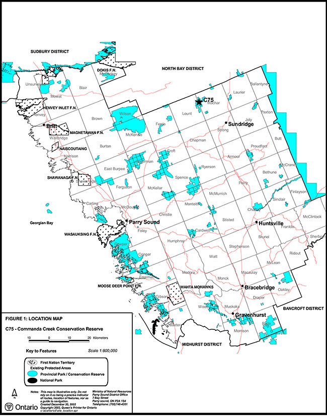
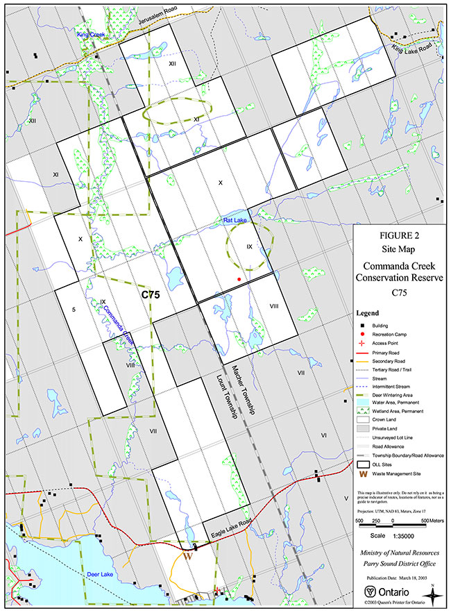
Commanda Creek Conservation Reserve consists of 1,657 hectares of Crown land, located about 12 kilometres west of the Village of South River. It is located in the Township of Machar and the unincorporated area of Lount Township, in the Territorial District of Parry Sound. It is surrounded almost entirely by privately owned lands, which are not part of this conservation reserve.
This conservation reserve, located in ecological Site District 5E-8, contains rolling hills with shallow sandy soils that are mixed with glacially deposited sand and gravel. There are bare bedrock patches, and flat sandy deposits that support forests and wetlands. Among the approximately 49 representative combinations of vegetation and landform types are hemlock forests, older sugar maple, spruce and balsam fir forests, with open and treed wetlands in the flat patches. The conifer stands support two small deer yards.
The area is used for a variety of traditional uses, including hunting.
Commanda Creek Conservation Reserve is one of 378 new protected areas approved through Ontario’s Living Legacy Land Use Strategy, aimed, in part, at completing Ontario’s system of parks and protected areas.
During the "Lands for Life" planning process, the public was widely consulted and provided valuable input into what became Ontario’s Living Legacy Land Use Strategy. Comments received during that time, and during consultation related to the formal Public Lands Act (Ontario Regulation 805/94) regulation of the boundaries of this conservation reserve, were generally supportive of the protection of this area. Stakeholders who provided comment during the earlier consultation for this site were subsequently consulted regarding the draft Statement of Conservation Interest and their comments were considered in the finalization of this document.
This Statement of Conservation Interest provides guidance for the management of the conservation reserve and provides the basis for the ongoing monitoring of activities. More detailed direction is not anticipated at this time. Should more complex resource management or conservation issues arise or significant facility development be considered, then a detailed Resource Management Plan will be prepared with full public consultation.
Commanda Creek Conservation Reserve is managed under the direction of the District Manager and the Bracebridge Area Supervisor of the Ministry of Natural Resources, Parry Sound District.
Approved by:
R. Griffiths
District Manager
Parry Sound District
Approved by:
Ron Running
Regional Director
Southcentral Region
1.0 Introduction
Ontario’s Living Legacy, the result of an extensive planning process that began in early 1997, culminated in the approval in July 1999 of a Land Use Strategy that identifies the intended strategic direction for Crown land, including the completion of Ontario’s system of parks and protected areas. This process, which included extensive public consultation, resulted in the recommendation for regulation of 378 new protected areas, including Commanda Creek Conservation Reserve (C75).
Commanda Creek Conservation Reserve consists of 1,657 hectares of Crown land, located about 12 kilometres west of the Village of South River. Roughly the eastern half of the site is located in the Township of Machar, and the western half in the unincorporated area of Lount Township, in the Territorial District of Parry Sound. It is surrounded almost entirely by privately owned lands, which are not part of this conservation reserve.
Commanda Creek Conservation Reserve is an area of heavily forested rolling hills, small lakes and creeks interspersed with wetlands. North trending Commanda Creek traverses the entire length of the conservation reserve near its western boundary.
This site was identified during the Ontario’s Living Legacy planning process as containing a diversity of landform and vegetation features, including glacial deposits of sand and gravel overlaying bedrock, rolling hills, bare rock knobs and extensive wetlands. The area has significant stands of eastern hemlock (Tsuga canadensis) and black spruce (Picea mariana). There are two small deer yards associated with these coniferous stands.
Public roads provide access to three sides of this conservation reserve, and there are several trails that penetrate the site. Traditional uses are hunting, fishing, the use of all-terrain vehicles, and hiking.
Conservation reserves are established under the authority of the Public Lands Act, Ontario Regulation 805/94. Commanda Creek Conservation Reserve was established by Ontario Regulation 148/02, under the authority of the Public Lands Act, on May 8, 2002.
A Statement of Conservation Interest (SCI) is prepared under the authority of Procedural Guideline A – Resource Management Planning (PL. Procedure 3.03.05). The purpose of this SCI is to identify and describe the values of Commanda Creek Conservation Reserve. The SCI also outlines the activities that currently occur within the conservation reserve and provides guidelines for the management of current and future activities in the context of protecting the natural, recreational and cultural values.
1.1 Background Information:
| Name | Commanda Creek Conservation Reserve (C75) |
|---|---|
| Site Region/District | Georgian Bay 5E-8 |
| OMNR Administrative Region/District/Area | Southcentral Region/Parry Sound District/ Bracebridge Area |
| Total Area (ha.) | 1,657 hectares |
| Regulation Date | May 8, 2002 (O. Reg. 148/02) |
| First Nations | Robinson-Huron Treaty |
| OBM map sheets | 20 17 6000 50700, 20 17 6100 50700, 20 17 6000 50800, 20 17 6100 50800 |
| Topographic Map | Golden Valley 31 E/13 |
| UTM co-ordinates | 17T 61200 507950 (Centroid) |
1.2 Representation
Earth Science Representation:
Bedrock - migmatitic felsic to mafic gneisses derived from the possibly metasedimentary protolith of the Powassan Domain, Algonquin Terrane, in the Central Gneiss Belt of the Proterozoic Grenville Province.
Surficial - ground moraine till, typical representation of the Wisconsinan Stage of the Quaternary Era in southwestern Ontario.
Life Science Representation:
- Coniferous forests on higher elevations, primarily eastern hemlock mixed with balsam fir (Abies balsamea) and some white spruce (Picea glauca)
- Hardwood forests associated with deeper soils on fresh to moist sites. These range from older, relatively undisturbed forests to younger stands with evidence of timber harvest as late as 20 years ago
- Treed fens of old growth black spruce and tamarack (Larix laricina)
- Graduated wetlands, from treed fen to ericaceous shrub land to graminoid/sedge meadow to riparian vegetation along the watercourses
Cultural Resources Representation:
Neither detailed cultural research nor inventory has been carried out for this conservation reserve. However, the presence of old large stumps indicates that this area was logged for white pine in mid to late 19th century. There is anecdotal evidence of an old abandoned mica mine on the south side of Rat Lake. The Eagle Lake Road, which touches the south edge of this conservation reserve, and the Jerusalem Road on the north side, were colonization roads providing access for communities to the east with the old Nipissing Road to the west. There is little other evidence of historic development within the site.
Recent regional evaluation (OMNR, 2003) shows that this conservation reserve contains areas that have a high potential for cultural heritage sites.
Recreational Opportunities:
A recreational inventory report was prepared for this site based on existing knowledge and data sources of MNR staff, as well as a number of site visits (Gavel, 2002). Currently, it is used for hunting, and fishing (Commanda Creek). A number of all-terrain vehicle trails are evident and are probably used in conjunction with hunting activity. The resources of the area are not particularly significant, other than being a significant block of Crown land in an area that is primarily privately owned.
1.3 Survey Work
| Survey Level | Earth Science | Life Science | Cultural | Recreational | Other |
|---|---|---|---|---|---|
| Reconnaissance | Duba & Frey, 2001 | Blythe & Assoc., 2002 | OMNR, 2003 | Gavel, 2002 | None |
| Detailed | None | None | None | None | None |
| Requirement | None | Monitor the status/presence of significant species and associations. | Research to be encouraged | Monitor use impacts | None |
2.0 Values to be protected
The conservation reserve is located entirely within Hills’ (1959) ecological Site District 5E-8. Values include earth science, life science and recreational/aesthetic values, with an emphasis on the life sciences.
2.1 Earth Science:
(Earth science information, unless otherwise noted, is taken from Duba & Frey, 2001)
Bedrock:
Commanda Creek Conservation Reserve is an area of heavily forested rolling hills, small lakes and creeks interspersed with wetlands. North trending Commanda Creek traverses the entire length of the conservation reserve near its western boundary. Bedrock is generally limited to small, flat lying outcrops at the edge of wetlands and lake shorelines. The quality of exposures is poor because of the extensive lichen cover that obscures bedrock textures and structures.
The dominant rock types are migmatitic felsic to mafic gneisses derived from the possibly metasedimentary protolith of the Powassan Domain, Algonquin Terrane, in the Central Gneiss Belt of the Proterozoic Grenville Province.
The Grenville Province is the product of thrusting and imbrication of the crust to the northwest as it collided with a continental landmass to the southeast. The Grenville Orogeny, circa 1140 to 1070 million years ago, culminated more than 500 million years of crustal evolution. The eroded roots of the products of these events are displayed in the complexly metamorphosed and deformed rocks of the region (Easton, 1992b, p.1302).
The Algonquin Terrane is one of four lithotectonic terranes of the Central Gneiss Belt. Within the Algonquin Terrane, the Powassan Domain is one of twelve structural domains. This geological environment is part of the modern organization of the complex products of the mid-Proterozoic Grenville orogenic events (Easton, 1992a and b). As such, its representation in Commanda Creek Conservation Reserve contributes to the conservation of the Grenville continental accretion theme outlined by Davidson (1981, p.107-111).
Within the Ontario Provincial Park system, the bedrock geological features observed in Commanda Creek Conservation Reserve have regional significance in their representation of a possible metasedimentary supracrustal component of the Powassan Domain, Algonquin Terrane.
Surficial:
Commanda Creek Conservation Reserve contains rolling hills with shallow sandy soils that are mixed with glacially deposited sand and gravel. There are bare bedrock patches, and flat sandy deposits that support forests and wetlands. The ice-flow direction is generally southward and the conservation reserve is underlain by thin till in a ground moraine, a typical representation of the Wisconsinan Stage of the Quaternary Era. Recent organic and bog deposits occupy the wetlands. Surficial geology of the conservation reserve is locally significant.
2.2 Life Science:
(Life science information, unless otherwise noted, is taken from Blythe & Associates, 2002)
The conservation reserve is located within Hills’ (1959) ecological Site District 5E-8. Life science significance is determined on the basis of the following criteria: representation, diversity, condition, ecological considerations and special features (Crins and Kor, 1998).
Representation:
Commanda Creek Conservation Reserve was identified during the Ontario’s Living Legacy planning process to contain a diversity of landform and vegetation features. These include glacial deposits of sand and gravel overlying bedrock hills, bare rock knobs and extensive wetlands associated with Commanda Creek and its tributary, Beaver Meadow Creek. Commanda Creek flows through a wide flat clay/silt plain deposited by post-glacial lake Algonquin. It exhibits a sinuous meander pattern, unlike most watercourses in the Precambrian Shield.
The bedrock terrain is fairly well covered by a mantle of sandy gravelly soils. There are few exposures of bedrock, usually associated with hillsides adjacent to steep valleys.
On higher elevations the forest is primarily coniferous with a significant component of eastern hemlock mixed with balsam fir and some white spruce. The acidic and nutrient-poor nature of the soils produces few herbaceous plants in the understory of this forest type. Typical ground cover includes an assortment of club mosses Lycopodium spp.), wintergreen (Gaultheria procumbens), marginal wood fern (Dryopteris marginalis) and twinflower (Linnaea borealis)
A range of hardwood forests is associated with deeper deposits of soil on fresh to moist sites. Dominant hardwood species are sugar maple (Acer saccharum), yellow birch, and black cherry (Prunus serotina). Infertile soils limit the range of species in these forests too, and the understory is represented by such species as wild sarsaparilla (Aralia nudicaulis), long awned wood grass (Brachelytrum erectum), intermediate wood fern (Dryopteris intermedia) and Canada mayflower (Maianthemum canadensis).
A second forest type occurs in areas with coarser textured stony glacial till. Sugar maple, red maple, and an unusually high representation of American beech dominate this forest type. These mature hardwoods have a relatively open canopy, with a dense understory, which shows heavy browsing by moose (Alces alces). The understory herbaceous and shrub species include Indian cucumber root (Medecia virginiana), white grass (Oryzopsis asperifolia), assorted club mosses (Lycopodium spp.), hay scented fern (Dennstaedtia punctilobula), beech drops (Epifagus virginiana), and fly honeysuckle (Lonicera canidensis).
The coniferous and hardwood forests of the southern portion of the conservation reserve vary in age and character, from undisturbed mature stands of hardwood to stands of 60 to 70 years of age which reflect evidence of logging, some as recently as 20 years ago.
The predominantly hardwood forests in the north o f the site do not show evidence of any significant disturbance. They contain relatively large diameter trees with open understories. The largest representative species in these forests are yellow birch and eastern hemlock.
The wide valleys of Commanda and Beaver Meadow Creeks are bordered with dense old growth forest primarily composed of black spruce and tamarack. These are, in essence, heavily treed fens. The forest floor has deep layers of sphagnum moss (Sphagnum spp.) with an understory of ericaceous shrubs, primarily Labrador tea (Ledum groenlandicum).
The black spruce forest is the first in a series of graduated wetland features, which grade out into the centre of the clay plains, where the actual watercourses run. As the black spruce forest thins out, the dominant species becomes Labrador tea in combination with other ericaceous shrubs. The shrub dominated zone gives way to a graminoid/sedge meadow and ultimately the riparian vegetation community of the creeks. The wetland areas comprise approximately one third of the conservation reserve area.
The area offers a suitable range of habitats for wildlife species typical to the region, such as: white-tailed deer (Odocoileus virginianus), moose, black bear (Ursus americanus), coyote (Canis latrans), eastern gray wolf (Canis lupus lycaon), beaver (Castor canadensis) and raccoon (Procyon lotor). There are two small deer yards associated with the coniferous stands.
Condition:
Most of this area shows limited evidence of early logging (some large old white pine stumps) and some of the stands on the south part of the site show more recent logging activity. A road crosses the conservation reserve from the south end (Lot 2, Concession 6, Lount Township) crossing Concessions 6 and 7 eventually leading to privately owned Lot 4, Concession 8.
Public access roads are adjacent to the conservation reserve on the north, east and south sides, but none cross the conservation reserve itself. There are all-terrain vehicle trails in the north portion of the site, apparently associated with hunting activity.
Diversity:
Although the terrain within this conservation reserve is diverse, the acidic, nutrient-poor soil conditions limit the botanical diversity of this site. With the exception of one provincially significant species, New England sedge (Carex novae angliae), the botanical species are unremarkable. Faunal diversity is also unremarkable.
Ecological Considerations
The conservation reserve forms part of the upper headwaters of Commanda Creek. The deep deposits of glacial till covered by mature forest provide an essential groundwater recharge area for the surrounding watercourses. The valley of Commanda Creek, and to a lesser extent Beaver Meadow Creek, are wide, flat and relatively undisturbed by human activity or structures. As such, they form an important wildlife corridor linking the northern areas of the French River, Restoule Lake and Lake Nipissing with the relatively remote and undisturbed landscapes of Lount and Ferrie Townships.
Special Features:
- Two small deer yards associated with the coniferous stands
- Commanda Creek is a coldwater creek that likely sustains populations of brook trout (Salvelinus fontinalis)
2.3 Cultural Values:
While no specific cultural studies or inventories have been undertaken within the conservation reserve, and no major cultural resource values have been evaluated or identified to date, the north part of this conservation reserve shows physical evidence of old roads and trails associated with early (late 19th century) colonization (Blythe & Associates, 2002).
Recent regional evaluation (OMNR, 2003) shows that this conservation reserve contains areas that have a high potential for cultural heritage sites.
2.4 Recreational/Aesthetic Values:
Commanda Creek Conservation Reserve is a long-standing traditional hunting area for moose, deer and bear. There is a Crown land recreational camp situated in the site, south of Rat Lake. There are also private land hunt camps abutting the conservation reserve and the members of these camps hunt within the site.
Most hunting activity within the conservation reserve focuses on the white-tailed deer, moose and black bear. To a much lesser extent other wildlife sought includes game birds, waterfowl, and small mammals.
All-terrain vehicle use within the conservation reserve has increased in recent years. All-terrain vehicles access the site via the following: the Eagle Lake Road; the King Lake Road; the trail that accesses the Crown land recreational camp; and from the private land hunt camp.
Commanda Creek and its tributaries are fished by canoe for brook trout. Canoe use is apparently concentrated in the spring and early summer, as low water makes paddling difficult later in the season. Portaging over beaver dams is frequently necessary.
It is unlikely people would canoe Commanda Creek for activities other than fishing or hunting.
3.0 Management Guidelines
3.1 Land Tenure:
Background:
Commanda Creek Conservation Reserve comprises 1,657 hectares of Crown land. In the Machar Township portion of the conservation reserve (basically, the eastern half), concession road allowances which cross or abut the conservation reserve remain under the authority of the Municipality of the Township of Machar, and are not included as part of the conservation reserve. In the unincorporated Lount Township side of the site, the road allowances are owned by the Crown, and are included within the conservation reserve. The township line road allowance between the two townships is not a part of the conservation reserve.
Commanda Creek Conservation Reserve is almost totally surrounded by private land, except where it abuts Lot 5 and the south part of Lot 4, Concession 5, and Lot 5, Concession 10 in Lount Township, which are Crown land. There is no intent to acquire adjacent private lands for addition to the conservation reserve.
The northern half of the conservation reserve lies within Bear Management Areas PS-4 9-16 and PS-49-17. It also occupies portions of three assigned Bait Fish Blocks (Machar 1, Lount 2 & 3). There is one registered trapline (BR-39) that extends into the conservation reserve, with an associated trap cabin within the site. There is one authorized recreation camp within the boundaries of the conservation reserve.
Guideline:
A number of areas of road allowance in Lount Township are included in the conservation reserve, and MNR proposes to stop up and close these in the near future, to ensure that they remain within the conservation reserve should the area at some point be incorporated into a municipality.
The sale of Crown lands within the conservation reserve is generally not permitted. Exceptions will only be considered under unusual circumstances, such as where an adjacent privately owned parcel has inadequate area for the installation of a septic system.
There are no plans by the MNR to acquire private lands to add to the conservation reserve.
The commercial bear hunting service associated with the current Bear Management Areas is allowed to continue. Fur harvest is permitted to continue in the registered trapline area. The Bait Fish Blocks, currently assigned, is permitted to continue.
The existing recreation camp within the conservation reserve is permitted to continue. It may be eligible for "enhanced" tenure, but is not eligible for purchase of land. (See Appendix 4)
New recreation camps are not permitted in this conservation reserve.
Resolution of the known unauthorized occupations of Crown land will be addressed.
3.2 Development:
Background:
There are no Crown owned buildings or other facilities within the conservation reserve. There is one road crossing a portion of the conservation reserve from Lots 2 and 4, Concession 5, Lount Township, providing access to private land in Lot 4, Concession 8, Lount Township.
A solid waste management facility operates just south of the conservation reserve, on the Crown portion of Lot 4, Concession 5, Lount Township.
Guideline:
New roads for resource extraction and/or private use will not be permitted, nor will additions to existing roads, or up-grading of existing roads be permitted. The one potential exception would be in Concession 5, Lount Township. It may be determined necessary in the future to permit construction of a small section of road from Eagle Lake Road across Lot 4, Concession 5, Lount Township, in the event that access across private land to Crown land becomes legally unavailable. There is no intention to develop roads outside of the conservation reserve to improve access to this site.
No mineral exploration is permitted within this conservation reserve. This policy direction is based on a commitment made by the Ministry of Natural Resources and the Ministry of Northern Development and Mines in March, 2002. This direction replaces that identified in the 1999 Ontario’s Living Legacy Land Use Strategy (OMNR, 1999), which stated that controlled mineral exploration would be permitted in new conservation reserves which were identified as having provincially significant mineral potential.
While there is no intent at present to provide or permit any new development in this conservation reserve that would require lighting, should this be considered at some point in the future the MNR will not allow unnecessary, undirected light pollution. This commitment recognizes the wilderness values provided by a pristine night sky.
3.3 Recreational Activities:
Background:
The area accommodates big game hunting, fishing, and the use of all-terrain vehicles. Commanda Creek Conservation Reserve is a long-standing traditional hunting area for moose, deer and bear. There is a Crown land recreational camp situated in the site, south of Rat Lake. There are also private land hunt camps abutting the conservation reserve and the members of these camps hunt within the site. Most hunting activity within the site focuses on the white-tailed deer, moose and black bear. To a much lesser extent, other wildlife sought includes game birds, waterfowl, and small mammals.
All-terrain vehicle use within the conservation reserve has increased in recent years. All-terrain vehicles can access the site via the Eagle Lake Road; from the King Lake Road; from the trail that accesses the Crown land recreational camp or from the private land hunt camp.
There is little evidence of the use of the conservation reserve by hikers, birdwatchers, canoeists (for other than fishing), mountain bikers, skiers, or snowshoers.
Guideline:
Hunting and fishing are permitted to continue within the conservation reserve.
Recreational use such as hiking, wildlife viewing, snowshoeing, and cross-country skiing, while currently very limited in extent and therefore not managed, will be allowed to occur in the conservation reserve.
The use of pre-existing recreational trails, and any increase in use of all-terrain vehicles, will be monitored to ensure that the conservation reserve values are not being adversely impacted. Depending on the results of monitoring, some trails may need to be redirected from sensitive areas or eliminated completely. Otherwise, there is no intent to mark or upgrade such trails.
New recreational trails may be considered on a case by case basis provided they meet the Procedural Guideline B - Land Uses - Test of Compatibility (Appendix 1) and the MNR's Environmental Assessment Act requirements. Off-trail use of snowmobiles and all-terrain vehicles is only permitted for the direct retrieval of game.
New recreational activities will be considered on a case by case basis provided they are consistent with maintaining the values of the conservation reserve and comply with Procedural Guideline B - Land Uses - Test of Compatibility (Appendix 1). Emphasis will be placed on activities that have a low impact on the environment of the conservation reserve.
3.4 Commercial Activities:
Background:
There has been no recent commercial forest harvesting or mining activity within the conservation reserve.
There is currently one registered trapline covering this conservation reserve. The guiding of non-resident bear hunters is authorized through two Bear Management Areas and bait fish harvesting is authorized through three Bait Fish Block licences which cover the site.
Guideline:
Fur harvesting, bear hunting services and bait fish harvesting operations are allowed to continue within the conservation reserve.
Mineral exploration is not allowed in this conservation reserve, as discussed in Section 3.2.
Conservation reserve regulations do not permit mining, commercial forest harvesting, hydroelectric power development, the extraction of aggregate and peat or other industrial uses (Public Lands Act, Ontario Regulation 805/94). Other new commercial activities must meet the requirements of Procedural Guideline B (see Appendix 1).
3.5 Aboriginal Interests:
Background:
This site is located within the area of the Robinson – Huron Treaty of 1850, and as such the general area of this conservation reserve is known to be of interest to various First Nations.
Guideline:
The regulation and management of this conservation reserve will not impede the exercise of existing aboriginal or treaty rights. These rights include hunting, fishing, fur harvesting, gathering of plants for a variety of purposes, and the use of ceremonial sites.
While there are no existing First Nation land claims that extend to this site, it is recognized that at some point in the future there is a possibility of a land claim in this area. If such a land claim is determined to be valid, the conservation reserve designation is not irreversible and does not preclude consideration of these lands in the settlement of a claim.
3.6 Natural Resource Stewardship:
Vegetation management for specific purposes (other than historic logging) is not known to have occurred in the past. Wildlife and fisheries management has been occurring according to the prevailing policies and legislation.
The emphasis will be on ensuring that the natural values of the conservation reserve are not negatively affected by current and future activities. Therefore, applications for new specific uses will be carefully studied and reviewed. Necessary studies may be undertaken by proponents, the Ministry, and/or partner organizations.
Guideline – Vegetation:
The intent of this site is to allow the existing vegetation communities to evolve naturally.
An exception to the above may occur in portions of Commanda Creek Conservation Reserve that are used as winter deer yards. Vegetation management and featured species management (deer in this case) is consistent with Conservation Reserve Policy PL 3.03.05.
The purpose of habitat management would be preservation and in some cases regeneration of the conifer trees, especially hemlocks, which provide cover from winter conditions, along with the creation of areas of browse in close proximity to conifer cover. It is anticipated that this habitat management would occur during the winter, thereby alleviating the need for any new/upgraded roads to undertake this activity.
Prior to work of this nature being done, a vegetation management plan would be completed by MNR and approved by the MNR District Manager. This vegetation management plan would be directed by local MNR specialists (e.g. area forester, area wildlife biologist) and reviewed with life science specialists/ecologists of Ontario Parks, to ensure that the habitat management would not adversely affect the natural heritage and ecological representation values of this conservation reserve. Depending on the size of the areas to be managed, this vegetation management plan may also be reviewed with local and provincial organizations that may have an interest in this area or this habitat management activity. The habitat management prescriptions would generally be consistent with the approved Area of Concern provisions used for forestry operations in identified deer yards in the French - Severn Forest Management Plan, which in turn is derived from Forest Management Guidelines for the Provision of White-Tailed Deer Habitat (OMNR 1997), except where modifications are needed to protect certain heritage values or features of this site.
The vegetation management plan could be implemented in several ways; for example, volunteer labour can be used if available or a commercial operator could be contracted by the MNR. In either case, it is expected that harvested forest products could be marketed commercially to offset the costs of the work.
The OMNR recognizes fire as an essential process fundamental to the ecological integrity of this conservation reserve. In accordance with existing conservation reserve policy and the Forest Management Strategy for Ontario, forest fire protection will endeavour to use "light on the land" techniques, which do not unduly disturb the landscape, in this conservation reserve. Examples of light on the land techniques may include limiting the use of heavy equipment, and limiting the number of trees felled during fire response efforts. Input from the local MNR Area Supervisor would be solicited if a forest fire threatens the area. Opportunities for prescribed burning to achieve resource management objectives may be considered. Plans for any prescribed burning will be developed in accordance with the OMNR Prescribed Burn Planning Manual.
Programs may be developed to control forest insects and diseases in the conservation reserve where these threaten significant values in or adjacent to the site. Where insects or disease threaten significant values, in or adjacent to the site, control will be directed as narrowly as possible to the specific insect or disease. Biological control will be used wherever possible. In all cases, regard shall be had for Procedural Guideline B (see Appendix 1).
Guideline – Wildlife and Fisheries:
The relevant Ontario hunting and fishing regulations will guide these activities within Commanda Creek Conservation Reserve. Fur harvesting and bait fish harvesting will be managed through the maintenance of the current licencing system.
The Ministry will monitor the impacts of snowmobile and all-terrain vehicles use on the natural values of the conservation reserve.
3.7 Cultural Resource Stewardship:
Background:
No specific cultural studies or inventories have been undertaken within the conservation reserve, and no specific significant cultural resource values have been evaluated or identified to date. Recent regional evaluation (OMNR, 2003) shows that this conservation reserve contains areas that have a high potential for cultural heritage sites.
Guideline:
Should the MNR consider either carrying out or permitting new structural development, significant clearing of vegetation or altering of land within this conservation reserve, the MNR will adhere to the cultural heritage resource screening process as is identified in its Memorandum of Understanding (MOU) with the Ministry of Tourism, Culture and Recreation (MTCR). While the purpose of this MOU is to provide a process to identify and protect cultural heritage resources when the MNR is reviewing work permits or disposing of Crown rights under the authority of the Public Lands Act, Ontario Regulation 805/94, the considerations and criteria would also enable the MNR to identify high potential cultural heritage areas for other purposes within conservation reserves. If the screening process indicates that the site of a proposed activity is within an area of high cultural heritage potential, the MNR will consult with the MTCR to determine the appropriate cultural heritage assessment requirements and will undertake a preliminary archaeological assessment if appropriate.
Interested partners will be encouraged to undertake inventories, studies, and research to document the First Nations, resource harvest/management and recreation history in the area. The MNR will discuss the appropriateness of archaeological assessment with local First Nations and the Ministry of Tourism, Culture and Recreation.
3.8 Client Services:
Background:
Access to the conservation reserve has generally been confined to traditional uses for the current commercial and recreational activities. There are no Crown facilities or services developed on or adjacent to the conservation reserve. The information fact sheet for this conservation reserve is currently available to the public through the Parry Sound District Office, Bracebridge Area Office or via the Internet at www.ontarioslivinglegacy.com (link is no longer active).
Guideline:
The focus will remain on low key information and self-interpretation of conservation reserve values and features. Consideration will be given to the preparation of an information brochure (with map) to highlight the features for which t he area was identified and appropriate uses to ensure the protection of those features.
Consideration will be given to the strategic location of identity signs where the public roads border the conservation reserve, and where trails approach or cross the conservation reserve boundary. There are no other plans for structural development within this conservation reserve.
3.9 Research:
Background:
Research to date has included a number of reconnaissance surveys to document earth science, life science and recreation values.
Guideline:
Research focusing on the assessment of use/activity impacts on wildlife species and habitats will be encouraged.
All research will be carried out in a non-destructive manner. Research proposals must follow Procedural Guideline C – Research Activities in Conservation Reserves (Appendix 3).
3.10 Marketing:
Background:
There has been no marketing of this conservation reserve to date. Promotion and information about this site has been primarily through the Ontario’s Living Legacy planning process and recent MNR Parry Sound District public consultation regarding the boundaries of this site.
Guideline:
Marketing activities of this conservation reserve will be kept to a minimum.
4.0 Implementation
Administrative responsibility for this conservation reserve belongs to the Bracebridge Area Office of the Parry Sound District of the Ministry of Natural Resources. The Area Office will continue to have the custodial care of Commanda Creek Conservation Reserve. Emphasis will be placed on awareness information highlighting reserve values, and monitoring and managing the current approved uses.
Priorities will include:
- Ensure compliance to prescribed management policies of the approved SCI.
- GPS location of existing trails, and classify their status and condition
- Monitor and evaluate recreational and commercial use levels and impacts
- Encourage further inventory and research of the significant life science resources of the conservation reserve
- Encourage research about impacts of snowmobiles and all-terrain vehicles on significant flora and fauna species and communities of the site
- Support cooperative ongoing education of resource users with respect to resource and land stewardship values, in order to maintain the ecological integrity of the site and to provide long term recreational opportunities; and
- Provide client services (e.g. brochure or fact sheet) at nearby MNR offices
5.0 Review and Revision of the Statement of Conservation Interest
This Statement of Conservation Interest will be amended through a standard process of minor and major amendments. Minor amendments will be processed in a relatively informal manner and will require the approval of the Area Supervisor. These amendments will deal with uses and activities that do not affect any of the policies in this SCI (e.g. new uses and/or activities that are consistent with existing permitted uses).
Uses and/or activities that were not anticipated in the approved SCI and which may have an impact on the values of the reserve will require a major amendment. This will include an opportunity for public comment and input, will require the approval of the District Manager and Regional Director.
6.0 References
Blythe, C. and Associates. 2002. Natural Heritage Area – Life Science Checksheet Commanda Creek Conservation Reserve. OMNR, Parry Sound.
Brunton, D. F. 1992. Life Science Areas of Natural and Scientific Interest in Site District 5E-8. OMNR, Algonquin Region, Huntsville.
Chapman, L. J. 1975. The Physiography of the Georgian Bay - Ottawa Valley Area of Southern Ontario. Ontario Division of Mines, GR 128, 35 p. Accompanied by Map 2228, scale 1 inch to 4 miles or 1:253,440.
Chapman, L. J. and Putman, D. F. 1984. Ontario Geological Survey, Special Volume 2. The Physiography of Southern Ontario. Ontario Ministry of Natural Resources.
Chapman, L. J. and Putman, D. F. 1984. Ontario Geological Survey, Special Volume 2, The Physiography of Southern Ontario, Third Edition. OMNR.
Crins, W. J. and Kor, P. S. G. 1998. Natural Heritage Gap Analysis Methodologies Used by the Ontario Ministry of Natural Resources. Unpublished Paper. Peterborough: OMNR.
Davidson, R. J. 1981. A framework for the conservation of Ontario’s earth science features. Ontario Ministry of Natural Resources, Toronto, 262 p.
Duba, D. and Frey, E. D. 2001. C99 Commanda Creek Conservation Reserve. Earth Science Report, OMNR Peterborough.
Easton, R. M. 1992a. The Grenville Province and the Proterozoic history of central and southern Ontario; in Geology of Ontario, Ontario Geological Survey, Special Volume. 4, Part 2, p.715-904.
Easton, R. M. 1992b. Tectonic evolution of Ontario. Part 3: Mesoproterozoic evolution of the southeast margin of Laurentia; in Geology of Ontario, Ontario Geological Survey, Special Volume 4, Part 2, p.1302-1314.
Gavel, P. 2002 Recreation Resource Inventory Report. Commanda Creek Conservation Reserve. OMNR Parry Sound.
Hills, G. A. 1959. A Ready Reference to the Description of the Land of Ontario and its Productivity. Ont. Dept. of Lands and Forests, Division of Research, Maple, Ontario.
Hoffman, D. W., Wicklund R. E. and Richards N. R. 1962. Soil Survey of Parry Sound District. Report No. 31 of the Ontario Soil Survey. Research Branch, Canadian Department of Agriculture and the Ontario Agricultural College.
Kor, P. S. G. and Delorme, R J. 1989. Quaternary Geology of the Magnetawan Area, Southern Ontario: Ontario Geological Survey, Preliminary Map P. 3134, Scale 1:50,000
Noble, T. W 1983. Biophysiographic Analysis, Site Region 5E, Algonquin Region, Ministry of Natural Resources. Algonquin Region, Huntsville.
Ontario Ministry of Natural Resources. 1999. Ontario’s Living Legacy: Land Use Strategy. Queen’s Printer for Ontario.
Ontario Ministry of Natural Resources. 2003. Cultural Heritage Registered Site Reserves and Areas of High Potential, Parry Sound District, Scale 1:150000.
Appendices
Appendix 1 Procedural Guideline B – Land Uses – Test of Compatibility (PL Procedure 3.03.05)
The conservation reserve policy provides broad direction with regard to the permitted uses. The policy provides only an indication of the variety of uses that will be considered acceptable in conservation reserves. The only caution is that "any new uses, and commercial activities associated with them, will be considered on a case by case basis, and, they must pass a test of compatibility to be acceptable."
What does a ‘test of compatibility’ mean?
An examination of this must start from the premise of why an area is set aside – specifically, its representative natural heritage values. Criteria are then identified to guide compatibility considerations. These criteria apply to the long-term acceptability of both existing uses and new uses.
-
Conformity to SCI/RMP: SCI describe values for which an area has been set aside and the range of appropriate uses that will be permitted in the area. SCI may also speak to the acceptability of other 'new' uses currently not occurring in the area.
The first 'test' is: "do proposed new land uses and/or commercial activities conform to the direction of the SCI/RMP for the conservation reserve? Would the new use(s) depart from the spirit of appropriate indicator land uses in the SCI/RMP?"
- Impact Assessment: If the proposed use(s) pass test 1 it is important to determine their impact on the area before they are approved. This should include the following:
- Impact on natural heritage values: "will the new use(s) impact any natural values in the area? If so how and to what degree? Is it tolerable?"
- Impact on cultural values: "will the new use(s) impact an historical or archaeological values in the area?"
- Impact on research activities: "will the new use(s) affect research activities in the area?"
- Impact on current uses: "will the new use(s) have any negative impact on the array of current uses?"
- Impact on area administration: "will the new use(s) increase administrative costs and/or complexity?" (For example, the cost of area monitoring, security and enforcement).
- Impact on accommodating the use outside the conservation reserve: "Could the use(s) be accommodated as well or better outside the conservation reserve?"
- Impact on socio-economics of the area: "will the new use(s) affect the community(ies) surrounding the area in a positive or negative way?" (For example, will the new use make an area less remote thereby affecting a local tourism industry that is dependent on the area’s remoteness for its appeal?"
- Impact on area accessibility: "does the new use(s) give someone exclusive rights to the area or a portion of the area to the exclusion of other existing uses?"
The following table (Appendix 2) provides a guide of indicator uses for the consideration of uses that may be permitted within conservation reserves. For any specific conservation reserve that test of compatibility should be applied to determine which specific uses are acceptable.
Appendix 2 Indicator Uses for Conservation Reserves: Generic and Specific
Recreation
| Activities | Generic Policy Permitted? Existing |
Generic Policy Permitted? New |
Specific Application in Commanda Creek Conservation Reserve C75 |
|---|---|---|---|
| Sport fishing | Yes | Yes | Yes |
| Sport hunting | Yes | Yes | Yes |
| Food gathering | Yes | Yes | YesA |
| Facility infrastructure | Maybe | Maybe | Maybe |
| Non-trail snowmobiling | No1 | No1 | No1 |
| Non-trail all-terrain vehicle use | No1 | No1 | No1 |
| Rock climbing/caving | Maybe | Maybe | N/A |
| Canoeing/kayaking | Yes | Yes | Yes |
| Motorized boating | Yes | Yes | Yes |
| Picnicking | Yes | Yes | Yes |
| Camping | Maybe | Maybe | Yes |
| Trails: Hiking | Yes | Maybe | MaybeB |
| Trails: X country skiing | Yes | Maybe | MaybeB |
| Trails: Cycling | Yes | Maybe | MaybeB |
| Trails: Horse riding | Yes | Maybe | MaybeB |
| Trails: Snowmobiling | Yes | Maybe | MaybeB |
| Trails: All-Terrain Vehicles | Yes | Maybe | MaybeB |
Science Education and Heritage Appreciation
| Activities | Generic Policy Permitted? Existing |
Generic Policy Permitted? New |
Specific Application in Commanda Creek Conservation Reserve C75 |
|---|---|---|---|
| Research | Yes | Yes | Yes |
| General walking | Yes | Yes | Yes |
| Photography & Painting | Yes | Yes | Yes |
| Wildlife viewing | Yes | Yes | Yes |
| Outdoor Education | Yes | Yes | Yes |
| Interpretation Collecting | No | Maybe2 | Maybe2 |
Commercial Activities
| Activities | Generic Policy Permitted? Existing |
Generic Policy Permitted? New |
Specific Application in Commanda Creek Conservation Reserve C75 |
|---|---|---|---|
| Food harvesting | Maybe | Maybe | No |
| Fishing | Maybe | Maybe | No |
| Baitfish harvesting | Yes | Maybe | Yes3 |
| Fur harvesting | Yes | Maybe | Yes3 |
| Trap cabins | Yes | No | MaybeC |
| Resort – outpost camp | Yes | No | MaybeC |
| Outfitting – bear management | Yes | No | Yes3 |
| Wild rice harvesting | Yes | Maybe | N/A |
Resource Management
| Activities | Generic Policy Permitted? Existing |
Generic Policy Permitted? New |
Specific Application in Commanda Creek Conservation Reserve C75 |
|---|---|---|---|
| Inventory monitoring | Yes | Yes | Yes |
| Featured species management | Maybe | Maybe | Maybe |
| Natural systems management | Maybe | Maybe | Maybe |
Industrial Activities
| Activities | Generic Policy Permitted? Existing |
Generic Policy Permitted? New |
Specific Application in Commanda Creek Conservation Reserve C75 |
|---|---|---|---|
| Timber harvesting | No | No | No |
| Mineral exploration | No | No | No |
| Mining | No | No | No |
| Hydro generation | No | No | No |
| Energy transmission corridors | Yes | No4 | No4 |
| Communications corridors | Yes | No4 | No4 |
| Public transportation corridors | Yes | No4 | Maybe4 |
| Resource access roads | Maybe | No | No |
| Private access roads | Maybe | No5 | Maybe5 |
Other Activities
| Activities | Generic Policy Permitted? Existing |
Generic Policy Permitted? New |
Specific Application in Commanda Creek Conservation Reserve C75 |
|---|---|---|---|
| Land Disposition | Maybe6 | No6 | No6 |
| Recreation Camps | YesC | No | YesC,D |
Notes:
On generic policy application in conservation reserves:
1For direct retrieval of game only
2Only as a part of an approved research project
3Transfer requests will be considered in the context of the Statement of Conservation Interest or Resource Management Plan for each conservation reserve
4Existing use is permitted to continue. New transportation corridors, communications lines, and transmission lines are discouraged in conservation reserves except under unusual circumstances where there are no other viable alternatives
5New private roads, including additions to existing roads, will not be permitted except where there are existing commitments
6Sale of Crown lands in conservation reserves is not permitted, except for certain minor dispositions (e.g. sale of small parcel of land where adjacent private lot is too small to enable installation of a septic system, or to facilitate legal title to lands where there has been a long-standing encroachment of a dwelling on Crown land) where they do not detrimentally affect the values an area is intended to protect
On specific policy application in Commanda Creek Conservation Reserve:
AFood gathering is permitted for personal consumption only and must be conducted in a sustainable manner, and such that it does not harm the values of the conservation reserve
BExisting authorized recreational trails are permitted to continue in conservation reserves as long as there are no significant environmental impacts and they do not impair the natural features and values for which the area is identified. Additional high impact recreational trails are discouraged, but new trails may be considered on a case by case basis, provided they comply with Procedural Guideline B – Land Uses – Test of Compatibility (Appendix 1)
CExisting authorized uses can continue. New cabins, outpost camps and private recreation camps are not permitted
DExisting authorized recreation camps are eligible for enhanced tenure, but not for the purchase of lands. A decision to grant enhanced tenure or to transfer recreation camps will be addressed through a screening process
Appendix 3 Procedural Guideline C Research Activities in Conservation Reserves (PL Procedure 3.03.05)
Purpose
To encourage contributions to the goal of conservation reserves by:
- Providing direction for research activities associated with conservation reserves; and
- Establishing a process for the review and approval of proposals by researchers, which could have an impact on the values protected by the conservation reserve
Definition
Research means any investigation or study of the natural, cultural, economic, management or other features or characteristics of conservation reserves.
Guidelines
Research will be encouraged to provide a better understanding of the natural values protected by a conservation reserve and to advance their protection, planning and management. The Statement of Conservation Interest will define, for each conservation reserve, the key research issues, set out the parameters within which research may occur and identify research needs.
Applications and Approvals
Researchers must apply in writing to the Area Supervisor for permission to conduct research. The request letter must contain a statement explaining why the proposed research should be undertaken in the particular conservation reserve in preference to another location.
Proposals will be reviewed and approved by the Area Supervisor, guided by the SCI prepared for each reserve (see Guideline A – Resource Management Planning) and using Guideline B – Land Uses – Test of Compatibility. Permission must be granted in writing, including any conditions to be met in conducting the research, prior to the undertaking of any research project.
Term and Conditions
Permission to conduct research under this policy will be valid for a period of 12 consecutive months from the date of issue. Permission to continue a research project for an additional periods of 12 months or less may be granted upon submission of a written request and a progress report. The Ministry may require the posting of collateral to assure that the terms and conditions of granting permission are met.
The Area Supervisor may suspend or revoke permission at any time for failure on the part of the researcher to meet:
- The intent of this policy
- The requirements under the Public Lands Act, Ontario Regulation 805/94 including all amendments, where applicable
- The requirements under any other Act or regulations of Ontario or Canada, including those governing the taking, handling, storing, confining, fur harvesting, excavating and marketing any specimen, artifact, information or action (for example, scientific collector’s permit)
- The conditions and agreements specified in granting permission
Final Report
The researcher will submit copies of reports, publications and theses following the results of the project to the Area Supervisor.
Appendix 4 Recreation Camp Tenure
Existing recreation camps within conservation reserves are generally permitted to continue. They may be eligible for "enhanced" tenure, but are not eligible for purchase of land. There are 2 forms of enhanced tenure that may be considered (as per September 22, 2000 direction from MNR's Assistant Deputy Ministers of Natural Resource Management and of Field Services):
- upgrade in the nature or type of tenure (e.g. from a Land Use Permit to a lease); and/ or
- an extension in the term of the tenure (e.g. from 1 year to 10 years)
Applications for enhanced tenure will be approved if determined acceptable using these screening criteria:
- Must follow the review process identified in MNR's land disposition policies:
- MNR District Manager must ensure that there will be no serious, foreseeable resource management or user conflicts as a result of the enhanced tenure;
- The intended use/activity will not likely impact on Goal 1, 2 or 3 of the Provincial Policy Statement, issued under Section 3 of the Planning Act
- The site conforms with the MNR's land use planning direction;
- The disposition is reviewed under the Environmental Assessment Act’s Exemption Order MNR 26/7;
- The site is not within a Provincial Significant Wetland (PSW). If the site is adjacent to a PSW it must be determined that the proposed enhancement of tenure will not have a negative impact on the function or natural features of the wetland;
- If the site is on lake trout lake, a lease will only be considered after such time as the policy on development on such lakes has been approved;
- Would not result in increased negative impact on natural heritage, cultural heritage or recreational values of the conservation reserve, or on existing authorized land uses;
- Must be subject to consultation with affected First Nations, and be consistent with any aboriginal land claim negotiations or protocol agreements;
- All rents, taxes, fees, rates or charges must be paid
A change in tenure does not convey a commitment to provide for, or agree to, a change in the type or the standard of existing access to the recreation camp.
Figure 1: Location of Commanda Creek Conservation Reserve
Enlarge figure 1: Location of Commanda Creek Conservation Reserve
Figure 2: Site Map – Commanda Creek Conservation Reserve
Enlarge figure 2: Site Map – Commanda Creek Conservation Reserve