Crane Lake Forest Conservation Reserve Management Statement
This document provides policy direction for the protection, development and management of the Crane Lake Forest Conservation Reserve and its resources.
Crane Lake Forest
Conservation Reserve (C27)
Statement of Conservation Interest
March 2005
Ministry of Natural Resources
Parry Sound District
Prepared with the assistance of:
Meteek & Company
Huntsville, Ontario
March 2005
Approval statement
We are pleased to approve this Statement of Conservation Interest for Crane Lake Forest Conservation Reserve (C27).
Crane Lake Forest Conservation Reserve consists of 387 hectares of Crown land, located about 10 kilometres south of the Town of Parry Sound. The northern portions are in Foley Ward in the Township of Seguin. The southern portions extend to the north shore of Stonehouse Lake and the north-west shore of Crane Lake in Conger Ward, in the Township of The Archipelago. The conservation reserve lies approximately one kilometre east of The Massasauga Provincial Park. Some adjacent lands to the east and west are privately owned, but the majority of its boundaries to the north and south abut against Crown lands.
This conservation reserve, located in Hills’ ecological Site District SE-7, protects mature hemlock forests and swamps, deciduous forests dominated by sugar maple and red oak, and various small wetlands, including white pine swamps, tamarack fens, graminoid peatlands, sedge marshes and meadow marshes.
This area is used for a variety of traditional recreational pursuits, including hunting, angling, food gathering and nature appreciation.
This conservation reserve is within the Georgian Bay Littoral Biosphere Reserve, which was recently designated by the United Nations Educational, Scientific and Cultural Organization. This designation “represents a common vision of sustainable development and environmental and cultural conservation” by a wide range of stakeholders of the area (UNESCO, 2004).
Crane Lake Forest Conservation Reserve is one of 378 new protected areas approved through Ontario’s Living Legacy Land Use Strategy, aimed, in part, at completing Ontario’s system of parks and protected areas.
During the “Lands for Life” planning process, the public was widely consulted and provided valuable input into what became Ontario’s Living Legacy Land Use Strategy. Comments received during that time, and during consultation related to the formal Public Lands Act regulation of the boundaries of this conservation reserve, were generally supportive of the protection of this area. Stakeholders who provided comment during the earlier consultation for this site were subsequently consulted regarding the draft Statement of Conservation Interest and any comments were considered in the finalization of this document.
This Statement of Conservation Interest provides guidance for the management of the conservation reserve and provides the basis for the ongoing monitoring of activities. More detailed direction is not anticipated at this time. Should more complex resource management or conservation issues arise or significant facility development be considered, then a detailed Resource Management Plan will be prepared with full public consultation.
Crane Lake Forest Conservation Reserve is managed under the direction of the District Manager and the Parry Sound Area Supervisor of the Ministry of Natural Resources, Parry Sound District.
Signed and approved by:
R. Griffiths
District Manager
Parry Sound District
Signed and approved by:
Ron Running
Regional Director
Southern Region
1.0 Introduction
Figure 1: Location of Crane Lake Forest Conservation Reserve (C27)
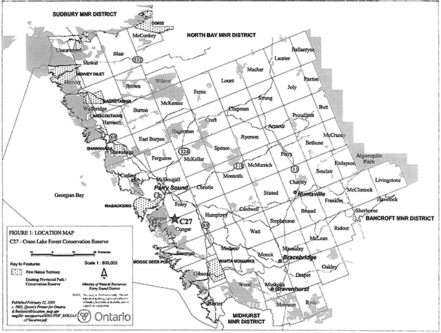
Enlarge figure 1: Location of Crane Lake Forest Conservation Reserve (C27) (PDF)
Figure 2: Site Map-Crane Lake Forest Conservation Reserve (C27)
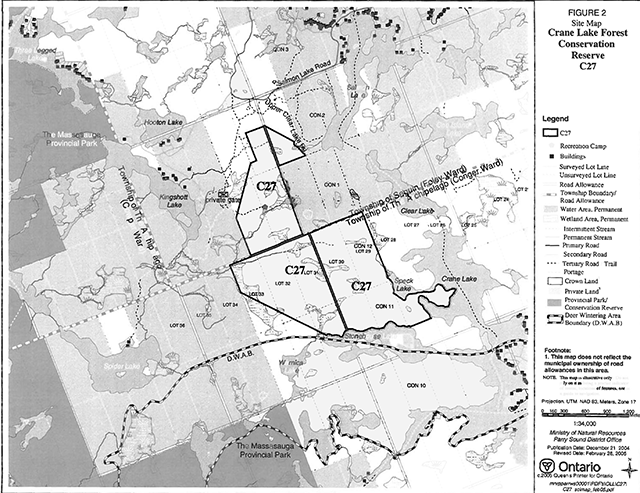
Enlarge figure 2: Site Map-Crane Lake Forest Conservation Reserve (C27)(PDF)
Ontario’s Living Legacy, the result of an extensive planning process that began in early 1997, culminated in the approval in July 1999 of a Land Use Strategy that identifies the intended strategic direction for Crown land in central and northern Ontario, including the completion of Ontario’s system of parks and protected areas. This process, which included extensive public consultation, resulted in the recommendation for regulation of 378 new protected areas, including Crane Lake Forest Conservation Reserve (C27).
Crane Lake Forest Conservation Reserve consists of 387 hectares of Crown ·land, located about 10 kilometres south of the Town of Parry Sound. The northern portions are in Foley Ward in the Township of Seguin. The southern portions extend to the north shore of Stonehouse Lake and the north-west shore of Crane Lake in Conger Ward, in the Township of The Archipelago. Privately owned lands are located to the east and west of this conservation reserve, but the majority of its boundaries to the north and south abut against Crown lands which form a continuous corridor to The Massasauga Provincial Park approximately one kilometre to the south-west.
Crane Lake Conservation Reserve protects provincially significant examples of hemlock-sugar maple forests on ground moraine in Hills’ ecological Site District 5E-7, and habitat for provincially significant flora and fauna. Much of the site shows little evidence of disturbance for decades, and extensive forest stands display old growth characteristics.
The conservation reserve is a traditional hunting area, primarily for big game species. The adjacent lakes are recognized as a canoeing destination. Angling is a popular activity on Crane Lake, with lake trout, smallmouth bass, pike and walleye as target species. The site is known to be used for gathering of wild foods for personal use.
This conservation reserve is within the Georgian Bay Littoral Biosphere Reserve, which was designated by the United Nations Educational, Scientific and Cultural Organization on October 29, 2004. This biosphere reserve covers the eastern coast of Georgian Bay, from Port Severn to the Key River, and extends from roughly the middle of Georgian Bay inland more or less to Highway 69/400. This designation “represents a common vision of sustainable development and environmental and cultural conservation” by a wide range of stakeholders of the area (UNESCO, 2004).
Conservation reserves are established under the authority of the Public Lands Act, Ontario Regulation 805/94. Crane Lake Forest Conservation Reserve was established by Ontario Regulation 237/03 on June 28, 2003.
A Statement of Conservation Interest is prepared under the direction of Procedural Guideline A - Resource Management Planning (PL. Procedure 3.03.05). The purpose of this Statement of Conservation Interest is to identify and describe the values of Crane Lake Forest Conservation Reserve. The Statement of Conservation Interest also outlines the activities that currently occur within the conservation reserve and provides guidelines for the management of current and future activities in the context of protecting the natural, recreational and cultural values.
1.1 Background information:
| Name | Crane Lake Forest Conservation Reserve (C27) |
|---|---|
| Site Region/District | Georgian Bay Site Region, Site District 5E-7 |
| OMNR Administrative Region/District/Area | Southern Region/ Parry Sound District/ Parry Sound Area |
| Total Area (ha.) | 387 hectares |
| Regulation Date | June 28, 2003 (O. Reg. 237/03) |
| First Nations | Robinson-Huron Treaty and Williams Treaty |
| OBM map sheets | 10 17 5800 50000 |
| Topographic Map | Lake Joseph 31 E/4 |
| UTM co-ordinates | 17T 58074 500876 (Centroid) |
1.2 Representation
Earth science representation:
Bedrock -- Rock types of the Moon Island gneiss association of the Parry Sound Domain, Parry Sound Terrane, of the Central Gneiss Belt in the Proterozoic Grenville Province..
Surficial -- Bedrock knobs and ridges with discontinuous shallow till over bedrock. Some drumlin-like features are in evidence on aerial photos.
Life science representation:
Crane Lake Forest Conservation Reserve provides representation of extensive mature hemlock forests and swamps, deciduous forests dominated by sugar maple (Acer Saccharum) and red oak (Quercus rubra), and various small wetlands. These occur within two biophysical units: ’Weakly broken shallow sandy till plain (bedrock, organic)“ (la-23) in the eastern portion; and, ”moderately broken bare bedrock upland (sandy till)" (VIIa-9) in the west.
Cultural resources representation:
Neither detailed cultural research nor inventory has been carried out for this conservation reserve.
Recent regional evaluation (OMNR, 2003) shows that shorelines of lakes adjacent to this conservation reserve have a high potential for cultural heritage sites.
Recreational opportunities:
A recreational inventory report was prepared for this site based on existing knowledge and data sources of MNR staff, as well as several site visits (Larson, 2004). Currently, it is used primarily for hunting of large game species, although some small game and waterfowl hunting occurs as well. The site is used for some limited gathering of wild foods. Adjacent lakes are a part of a system known as a canoeing destination. Fishing is a popular activity in adjacent lakes.
1.3 Survey work
| Survey Level | Earth Science | Life Science | Cultural | Recreational | Other |
|---|---|---|---|---|---|
| Reconnaissance | Blackburn, 2003 | Jalava, 2001 | OMNR, 2003 | Larson, 2004 | None |
| Detailed | None | None | None | None | None |
| Requirement | None | Monitor the status/presence of significant species and associations. | Research to be encouraged | Monitor use impacts | None |
2.0 Values to be protected
The conservation reserve is located entirely within Hills’ (1959) ecological Site District 5E-7. Values include earth science, life science and recreational/aesthetic values, with an emphasis on the life sciences.
2.1 Earth science:
(Earth science information, unless otherwise noted, is taken from Blackburn, 2003)
Bedrock:
Crane Lake Forest Conservation Reserve lies within the Parry Sound Domain, Parry Sound Terrane, in the Central Gneiss Belt of the Proterozoic Grenville Province (Lumbers & Vertolli, 2000 a & b). Within this Domain, the Moon Island gneiss association is represented in this conservation reserve. However, it is probably better represented in other, larger, conservation reserves in the Parry Sound Domain.
The Grenville Province is the product of thrusting and imbrication of the crust to the northwest as it collided with a continental landmass to the southeast. The Grenville Orogeny, circa 1140 to 1070 million years ago, culminated more than 500 million years of crustal evolution. The eroded roots of the products of these events are displayed in the complexly metamorphosed and deformed rocks of the region (Easton, 1992b).
The Parry Sound Terrane is one of the four lithotectonic terranes of the Central Gneiss Belt. The Parry Sound Domain is one of three structural domains of the Parry Sound Terrane. This geological environment is part of the modern organization of the complex products of the mid-Proterozoic orogenic events (Easton 1992a & b). As such, their representation in Crane Lake Forest Conservation Reserve contributes to the conservation of the Grenville Province continental accretion theme (Davidson, 1981).
Within the Ontario Provincial Park system, the Moon Island gneiss association features observed in Crane Lake Forest Conservation Reserve are of local significance in their representation of components of the Parry Sound Domain, Parry Sound Terrane.
Surficial:
Crane Lake Forest Conservation Reserve is characterized by bedrock knobs and plains. The area is comprised of discontinuous shallow till over bedrock, with pockets of organic material in lower lying areas. Two crude potholes were observed at the north end of the site. Aerial photography shows numerous ovoid structures in line trending west-southwest, that resemble drumlins. Further investigation is warranted.
2.2 Life science:
(Life science information, unless otherwise noted, is taken from Jalava, 2001)
The conservation reserve is located within Hills’ (1959) ecological Site District 5E-7. Life science significance is determined on the basis of the following criteria: representation, diversity, condition, ecological considerations and special features (Crins and Kor, 1998).
Representation:
Crane Lake Forest Conservation Reserve protects extensive mature hemlock forests and swamps, deciduous forests dominated by sugar maple and red oak, and various small wetlands, including white pine swamps, tamarack fens, graminoid peatlands, sedge marshes and meadow marshes. These natural communities occur on ground moraine situated on rolling granitic ridges and valleys (Brunton 1993). According to current MNR digital biophysical mapping , the site occurs almost entirely within two biophysical units. “Weakly broken shallow sandy till plain (bare bedrock, organic)” (la23) covers slightly more than half of the site on the east, while “moderately broken bare bedrock uplands (sandy till)” (VIIa-19) occupies the western portion. ’Weakly broken bare bedrock plain" (VIIa-7) is mapped along a narrow fringe along the southern boundary. However, field observations indicate relatively deep overburden along this southern fringe, suggesting that the indication of biophysical unit Vlla-7 within the site is probably an artefact relating to mapping scale or minor digitization error. Soils throughout the site are typically stony sandy till, with peat and organic muck occurring in wetland depressions, and with some of the higher open bedrock ridges virtually devoid of soil.
Weakly Broken Shallow Sandy Till Plain (bare bedrock, organic) (la-23):
Higher bedrock ridges within the la-23 unit support scattered small dry acidic rock barren communities dominated by sparse to dense patches of crinkled hairgrass (Deschampsia flexuosa) and poverty oat grass (Danthonia spicata) in very shallow soils. Mosses (e.g., Polytrichum spp..), and reindeer lichen (Ciadina rangiferina) are typically common on the open bedrock. White oak (Quercus alba), red oak (Q. rubra) and eastern white pine (Pinus strobus) trees and saplings are scattered on these barrens, and occasional dense patches of common juniper (Juniperus communis) and lowbush blueberry (Vaccinium angustifolium) also occur.
These higher ridges also support shallow-soiled dry red oak - white oak bedrock woodlands, often with scattered red maple (Acer rubrum) or sugar maple (Acer saccharum ssp. saccharum) trees in moister depressions. The deeper depressions sustain small sphagnum bogs, with very sparse herbaceous cover; elsewhere crinkled hairgrass is dominant in the understorey.
Oak-dominated forests are very common on deeper (but bedrock-controlled) dry - fresh sandy till soils, particularly in the eastern and northern portions of la-23 within the site. White-grained mountain-rice (Oryzopsis asperifolia), eastern bracken fern (Pferidium aquilinum), wild sarsaparilla (Aralia nudicaulis) and wild lily-of-the-valley (Maianthemum canadense) are dominant in the herb layer. Young to intermediate-aged dry - fresh oak - red maple forests also occur on these bedrock ridges and rocky slopes, with white oak, large-toothed aspen (Populus grandidentata) and sugar maple as secondary dominants or associates, and with bracken fern and wild sarsaparilla common in the understorey.
Deeper-soiled uplands in the south-central portion of the site support extensive, relatively mature hemlock forests on dry - fresh and fresh - moist substrates. Hemlock (Tsuga canadensis) trees in these virtually undisturbed stands are often up to 70 cm diameter at breast height (dbh). Common co-dominants with hemlock are yellow birch (Betula alleghaniensis) and sugar maple, and less frequently red maple, with a sapling layer of striped maple (Acer pensylvanicum). The sparse herb layer is typically shining club-moss (Huperzia lucidula), wild lily-of-the-valley, wild sarsaparilla, marginal wood fern (Dryopteris marginalis), bluebead lily (Clintonia borealis), and occasionally oak fern (Gymnocarpium dryopteris), evergreen wood fern (Dryopteris intermedia) and goldthread (Coptis trifolia). Poorly-drained depressions in these hemlock stands occasionally support ephemeral ponds, even on ridge plateaus; these depressions are usually sparsely vegetated, but provide potential breeding habitat for frog and salamander species.
The south-facing slope and the plateau of an extensive ridge along the southern edge of the site supports impressive, mature, undisturbed sugar maple-dominated deciduous and mixed forests. These stands show characteristics of old-growth: a full spectrum of age classes of trees; frequent fallen and rotting trees; canopy gaps; and large trees with yellow birch and sugar maple to 70 cm dbh, American beech (Fagus grandifolia) and white birch (Betula papyrifera) to 50 cm dbh, and basswood (Tilia americana) to 80 cm dbh. The understorey tends to be sparse in deeply-shaded sections and dominated by various clubmosses and ferns, but is more extensive in canopy gaps, where it is dominated by the same species or, in one rich example, by purple trillium (Trillium erectum) and woolly sweet-cicely (Osmorhiza claytonil). These south-facing slopes also supports small, relatively rich seepage meadow marshes dominated by marsh blue violet (Viola cucullata), spotted touch-me-not (Impatiens capensis), and northern lady fern (Athyrium filix-femina).
A low-lying area between bedrock ridges near the centre of the site supports a 10 hectare very moist red maple - white pine mixed forest with swampy sections. This undisturbed community has a distinctive extensive tall shrub layer dominated by showy mountain ash (Sorbus decora), northern wild raisin (Viburnum cassinoides), and mountain holly (Nemopanthus mucronatus) under an open canopy of red maple and semi mature white pine trees, some of them reaching 70 cm dbh. An extensive low shrub layer of lowbush blueberry and an herb layer strongly dominated by goldthread emerge out of a sphagnum-covered substrate. This community grades southward into an impressive mature hemlock- red maple swamp with scattered large white pine trees, a mountain holly tall shrub layer, and a dense cinnamon fern (Osmunda cinnamomea) herb layer in sphagnum. Other swamps within this biophysical unit tend to be relatively small, and are usually dominated by black ash (Fraxinus nigra) trees and extensive saplings, often co-dominant with yellow birch, eastern white cedar (Thuja occidentalis) or hemlock. Winterberry (llex verticillata) and northern wild raisin are common in the tall shrub layer, and the often-extensive herb layer is typically dominated by northern water horehound (Lycopus uniflorus), sensitive fern (Onoclea sensibilis), royal fern (Osmunda regalis) and cinnamon fern. A mature white pine coniferous swamp occurs at the north end of the site, straddling the la-23 - Vlla-19 biophysical unit boundary.
The site’s only extensive marshes and meadow marshes occur in this biophysical unit. A mosaic of speckled alder (Alnus incana ssp. rugosa) thicket swamp and Canada blue-joint (Calamagrostis canadensis), reed-like three-way sedge (Dulichium arundinaceum), wild calla (Calla palustris), marsh fern (Thelypteris palustris) meadow marsh with peaty sections empties into Stonehouse Lake at the southwest end of the site. Beaver meadows flank the southern half of the site’s eastern boundary in the vicinity of Speck Lake. Minor examples of beaked sedge open fen and open water communities are mapped within this biophysical unit at the north end of the site, but occur primarily within unit Vlla-19.
Moderately Broken Bare Bedrock Uplands (sandy till) (Vlla-19):
The boundary between biophysical units la-23 and Vlla-19 was delineated at a relatively coarse scale (1:250,000), making its demarcation within the site somewhat artificial. It does not follow topographic features, meaning that many vegetation community patches straddle the boundary, with no distinct differences on either side of the boundary.
Most of this biophysical unit is covered in semi-mature to mature fresh hemlock forests on rolling bedrock controlled topography, with sugar maple being the most frequent co-dominant, often with red oak, white ash (Fraxinus americana), yellow birch and red maple as associates. Common understorey species are wild lily of-the-valley, wild sarsaparilla, peduncled sedge (Carex pedunculata) and starflower (Trientalis borealis), with richer, moister examples occasionally dominated by evergreen wood fem, oak fern and northern beech fern (Phegopteris connectilis). Deeper soils on lower ridge-slopes and bottomlands support fresh semi-mature hemlock conifer stands, often with a dense, almost single-species tree layer, or occasionally with sugar maple, beech and yellow birch as associates. The understorey is typically very sparse, with scattered wild sarsaparilla and evergreen wood fern and other shade-tolerant herbs.
Small patches of open rock barren occur atop some bedrock ridges, particularly in the southeastern portion of the site. Ridges and plateaus with slightly deeper soils sustain minor examples of red oak - white oak woodlands, and dry- fresh red oak- red maple and red oak- sugar maple stands compositionally similar and contiguous with those to the east in biophysical unit la-23.
The extreme western boundary of the site contains part of an undisturbed hemlock conifer swamp, which straddles the mapped boundary of biophysical unit Vlla-19 and Vlla-7. The community has an open canopy, but a sparse herb layer dominated by goldthread, cinnamon fern, bunchberry (Comus canadensis). There is an 8 hectare semi-mature to mature white pine coniferous swamp at the north end of the site. This wetland is situated in a broad bedrock depression and has a hummocky sphagnum-dominated organic substrate. Tamarack (Larix laricina) is a co-dominant in the relatively open canopy, which allows enough sunlight penetration to support an extensive mountain holly (Nemopanthus mucronatus) tall shrub layer. Sparse low shrub and herb layers are dominated by lowbush blueberry, velvet-leaf blueberry (Vaccinium myrtilloides), swamp dewberry (Rubus hispidus), cinnamon fern, water-horehound and starflower: This community grades into tamarack swamp and ultimately to a mountain holly thicket swamp towards the southeast. Two other substantial wetlands occur in the biophysical unit: a tamarack treed fen near the centre of the site and a beaked sedge open fen in the north-central portion of the site. The tamarack fen has a very open canopy, with black spruce (Picea mariana) and white spruce (P. glauca) as associates, and a diverse and variable understorey of three-way sedge, tawny cottongrass (Eriophorum virginicum), marsh fern, round-leaved sundew (Drosera rotundifolia) and beaked sedge. The beaked sedge open fen has a sparse low shrub layer of leatherleaf (Chamaedaphne calyculata) as a co-dominant, with silvery sedge (Carex canescens) and large cranberry (Vaccinium macrocarpon) as associates. Patches of open water occur in association with the beaked sedge fen along a system that drains out of the site to the southwest.
Weakly broken bare bedrock plain (Vlla-7)
Future finer-scale refinements to biophysical unit mapping may exclude this unit from the site, limiting it to areas immediately to the south and west. Currently it is mapped as occurring within the site along a narrow band along the north shore of Stonehouse Lake, and minor areas westward along the southern boundary of the site. Forest, swamp and rock barren communities along this strip are described under the adjacent biophysical units (above).
At the extreme south end of the site, much of the shoreline of Stonehouse Lake has a narrow band of sweet gale (Myrica gale) shrub fen, occasionally with small, floating open peat mats extending a few metres out into the lake. Winterberry is often co-dominant in the shrub layer, and the open mats are dominated by large cranberry, northern dewberry (Rubus flagellaris) and three-way sedge. Adjacent open water is dominated by white water-lily, floating hearts (Nymphoides cordata) and water-shield (Brasenia schreben).
Condition:
Among the most significant features of Crane Lake Forest Conservation Reserve, from a natural heritage protection perspective, is the outstanding quality of its hemlock forests and swamps, its mature sugar maple forests, and its impressive mixed and conifer peatlands. Much of the site shows little or no evidence of disturbance for many decades, and extensive forest stands display old-growth characteristics. Many of the higher, drier forests and rock barrens show evidence of past fire, probably within the past 100 years. An exceptionally low percentage (less than 2%) of the site’s vascular plant species are introduced.
Diversity:
Crane Lake Forest Conservation Reserve contains a diversity of 43 landform-vegetation types. These landform-vegetation types consist of 29 different ecological communities (at the ecosite level) occurring on 3 biophysical units. Based on 2001 fieldwork, the site provides habitat for 232 vascular plant species, of which 228 are native to central Ontario. The site supports 50 breeding bird species. Five mammal species, including extensive evidence of moose and black bear, were also recorded. The 7 amphibian species include the uncommon pickerel frog (Rana palustris).
Ecological considerations:
Crane Lake Forest Conservation Reserve protects a remarkably undisturbed part of a continuous natural landscape along the Georgian Bay Coast. It is situated only one kilometre northeast of The Massasauga Provincial Park. The site is part of an interior Crown Land corridor that extends from The Massasauga
Provincial Park north to the Parry Sound and south to the Healey Lake area. The conservation reserve provides habitat for forest-interior bird species, including red-shouldered hawk, and habitat for species that normally require relatively large tracts of natural landscape, such as black bear and moose. The site’s fresh - moist hemlock and sugar maple forests show characteristics of old growth, and are semi-mature to mature in age. Old-growth conditions, which are rare in south-central Ontario, provide an ideal matrix for natural succession, nutrient cycling and biological diversity. The site protects the headwaters of small streams of the Crane Lake - Blackstone Lake watershed to the east and south and the Kingshott Lake - Spider Lake watershed to the west. Groundwater seepage areas occur along some of the slopes, and the several wetlands and peatlands within the site perform groundwater recharge functions: The site also protects approximately 3 kilometres of shoreline along Speck, Crane and Stonehouse lakes.
Special features:
Special features at Crane Lake Forest Conservation Reserve include the presence of extensive old-growth and pristine older-growth hemlock - sugar maple forests on ground moraine. Such forests are relatively rare in ecodistrict 5E-7, and old-growth forests are rare in southern Ontario generally. The following vegetation types are considered globally and/or provincially rare (NHIC 2002):
- Vlla-19 Oak Acidic Treed Rock Barren - 5 hectares
- la-23, Vlla-19 White Pine Mineral Coniferous Swamp - 8 hectares
- la-23 Red Maple -White Pine Mineral Mixed Swamp Type - 10 hectares
- la-23 Red Maple - Hemlock Organic Mixed Swamp Type - 5 hectares
- la-23 Mountain Holly Organic Thicket Swamp Type - 3 hectares
The following Crane Lake Forest Conservation Reserve species are considered provincially significant:
- Red-shouldered Hawk (Buteo lineatus), Special Concern. Territorial Red-shouldered Hawks were noted within the site on all four site visits, suggesting probable breeding within the site. Ideal habitat of undisturbed mixed Hemlock - Sugar Maple forests with swamps and wetlands is present at the site for this species.
- Common Meadow Beauty (Rhexia virginica). Uncommon along shoreline shrub fens on north shore of Stonehouse Lake off Crane Lake, Conger Ward. Growing in Sphagnum with Myrica gale.
- The locally and provincially uncommon pickerel frog (Rana palustris) was observed calling in the beaver meadow along the site’s eastern fringe. A Broad-winged Hawk (Buteo platypterus) nest with young was found in a mature Sugar Maple forest stand.
Although no Eastern Massasauga rattlesnakes were found at the site during the 2001 field season, suitable habitat exists within the site, and there are numerous records of this nationally and provincially threatened species in the vicinity of Crane Lake Forest Conservation Reserve. Similarly, no Five-lined Skinks (national species of concern, provincially of special concern) were found, but suitable rock barren habitat is within the site.
2.3 Cultural values:
While no specific cultural studies or inventories have been undertaken within the conservation reserve, and no major cultural resource values have been evaluated or identified to date, recent regional evaluation (OMNR, 2003) provides generalized broad-brush mapping which shows that the shorelines of the lakes bordering this conservation reserve have a high potential for cultural heritage sites.
2.4 Recreational/aesthetic values:
(Recreational information, unless otherwise noted, is taken from Larson, 2004)
Crane Lake Forest Conservation Reserve is a small, geographically isolated area that attracts light to moderate use on a local scale.
Crane Lake Forest Conservation Reserve is a long-standing traditional hunting area for white-tailed deer, moose and black bear. Small game and waterfowl hunting is also frequent. There is one Crown land recreation camp within the conservation reserve. Private land owners in the immediate area and some portable hunt camps also use the area as hunting territory.
The gathering of wild foods is becoming a popular activity, and it was noted during the consultation process that this site is used for limited gathering of wild foods.
The diverse, mature forest cover, outcrop knobs and swamps of Crane Lake Forest Conservation Reserve suggest a potential for nature appreciation activities such as bird watching, nature study, photography, interpretation, and solitude.
No authorized recreational trails are located within the conservation reserve. A trail provides all-terrain vehicle access to the authorized Crown land recreation camp, but as it originates on private land and is gated at the private land, it does not provide public access to the conservation reserve.
The general area is widely known as a canoeing destination. The shores of Crane, Stonehouse and Speck Lakes provide access opportunities to the conservation reserve; however, they show little signs of recreational use. This is in part due to the steep heavily wooded nature of most of the shoreline adjacent to the conservation reserve.
The distance of this conservation reserve from urban areas has resulted in a relatively pristine night sky, which enhances the sense of remoteness and wilderness of this site. Pristine night skies are considered a significant value, given the increasingly limited areas of southern and central Ontario that are not heavily affected by light pollution.
3.0 Management guidelines
MNR’s Class Environmental Assessment for Provincial Parks and Conservation Reserves came into effect on January 10, 2005. All new MNR projects in conservation reserves, and any new approvals or permits issued, must meet the legal requirements of this Class Environmental Assessment, and any relevant amendments.
3.1 Land tenure: background:
Crane Lake Forest Conservation Reserve consists of 387 hectares of Crown land, located about 10 kilometres south of the Town of Parry Sound. The northern portions are in Foley Ward in the Township of Seguin. The southern portions extend to the north shore of Stonehouse Lake and the north-west shore of Crane Lake in Conger Ward, in the Township of The Archipelago. Privately owned lands (which are not part of this conservation reserve) are located to the east and west of this conservation reserve, but the majority of its boundaries to the north and south abut against Crown lands.
The municipal road allowances, including the original shore road allowance along Crane Lake and Stonehouse Lake are not part of the conservation reserve.
The conservation reserve is included within Bear Management Area PS-46-16. It lies within two Bait Fish Blocks (PS157 and PS133). It is within a registered trapline area (PS 187). There are no registered traplines cabins within the site.
There is one authorized recreation camp within the boundaries of the conservation reserve.
Guideline:
The sale of Crown lands within the conservation reserve is generally not permitted. Exceptions will only be considered under unusual circumstances, such as where a pre-existing, adjacent, privately owned parcel has inadequate area for the installation of a septic system; this circumstance is unlikely to apply for this conservation reserve.
There are no plans by the MNR to acquire private lands to add to the conservation reserve.
The commercial bear hunting service is allowed to continue in the current Bear Management Area. Fur harvest is permitted to continue in the registered trapline area, but new trapline cabins are not permitted in the conservation reserve. The Bait Fish Block, currently assigned, is permitted to continue.
The existing recreation camp within the conservation reserve is permitted to continue. It may be eligible for “enhanced” tenure, but is not eligible for purchase of land (See Appendix 4). Wh re authorized in writing, the Ministry of Natural Resources would consider permitting transfer of ownership, or alterations to authorized recreation camps, so long as there are no negative impacts on the values of the conservation reserve.
New recreation camps are not permitted.
3.2 Development:
Background:
There are no Crown owned buildings or other facilities within the conservation reserve.
A trail provides access from private land (Lot 33, Concession 1) to the Crown land recreation camp in Lot 31, Concession 1. This is known to be used to provide all-terrain vehicle access to the camp, but since it originates from private land, and is gated there, it is not generally accessible for public access. No other trails are known to enter this site, although Upper Clear Lake Road is adjacent to the north-east comer of the site boundary. Other trails lead from Salmon Lake Road to private land on or near Salmon Lake and Clear Lake, and also pass close to the conservation reserve.
Guideline:
New private access or resource access roads, and additions to or upgrading of existing roads are not permitted. There is no intention to develop or improve roads or trails outside of the conservation reserve to improve access to this site.
New recreational trails may be considered on a case by case basis, as is discussed in more detail in Section 3.3 “Recreational Activities”. New recreational trails for motorized vehicles are discouraged and will only be considered under exceptional circumstances if the criteria identified in Section 3.3 have been demonstrated.
Unauthorized works within the conservation reserve will be handled in accordance with the Public Lands Act, and any required removal of these works will be at the expense of those responsible.
No mineral exploration is permitted within this conservation reserve. This policy direction is based on a commitment made by the Ministry of Natural Resources and the Ministry of Northern Development and Mines in March 2002. This direction replaces that identified in the 1999 Ontario’s Living Legacy Land Use Strategy (OMNR, 1999), which stated that controlled mineral exploration would be permitted in new conservation reserves which were identified as having provincially significant mineral potential.
Any new development must meet MNR’s commitments to protect cultural heritage values (see Section 3.7).
While there is no intent at present to provide or permit any new development in this conservation reserve that would require lighting, should this be considered at some point in the future the MNR will not allow unnecessary, undirected light pollution. This commitment recognizes the wilderness and biological values provided by a pristine night sky.
3.3 Recreational activities:
Background:
The area accommodates big game hunting, and small game hunting, and some limited food gathering for personal use. There are no authorized recreational trails within the conservation reserve.
One authorized Crown land recreation camp is located within the conservation reserve.
The adjacent lakes provide for canoeing, angling and waterfowl hunting. There is potential for shore access associated with these activities on Crane Lake, Stonehouse Lake and Speck Lake, but the shoreline is generally too steep and heavily wooded to encourage this use.
There is little or no evidence of the use of the conservation reserve by hikers, birdwatchers, mountain bikers, skiers, or snowshoers.
Guideline:
Hunting is permitted to continue within the conservation reserve.
Recreational uses such as hiking, wildlife viewing, snowshoeing, and cross-country skiing, while currently very limited in extent and therefore not managed, are allowed to occur in the conservation reserve.
The use of pre-existing recreational trails (trails that existed at the time of regulation of this conservation reserve), and any increase in use of snowmobiles or all-terrain vehicles will be monitored to ensure that conservation reserve values are not being adversely impacted. Depending on the results of monitoring, pre existing trails may need to be redirected from sensitive areas or eliminated completely. There is no intent to mark or upgrade these trails.
New recreational trails may be considered on a case by case basis provided that they meet Procedural Guideline B- Land Uses- Test of Compatibility (see Appendix 1) and the MNR’s Environmental Assessment Act requirements. Public consultation will generally be required during the consideration of changes to existing trails, and will always be required for new trails. Any new trails must meet MNR’s commitments to protect cultural heritage values (see Section 3.7).
New recreational trails or upgrading of existing trails for motorized vehicles are discouraged and will only be considered under exceptional circumstances if the following have been demonstrated:
- there is a community need for the trail, as well as community support;
- there are no alternative suitable locations outside the conservation reserve;
- the trail location would be acceptable and suitable for four-season use;
- the trail would meet the requirements applicable to all trails, as identified in the preceding paragraph. Off-trail use of snowmobiles and all-terrain vehicles is not permitted, except for the direct retrieval of game.
New recreational activities will be considered on a case by case basis provided they are consistent with maintaining the values of the conservation reserve and comply with Procedural Guideline B - Land Uses - Test of Compatibility (Appendix 1). Emphasis will be placed on activities that have a low impact on the environment of the conservation reserve.
Food gathering is permitted for personal consumption only and must be conducted in a sustainable manner, and such that it does not harm the values of the conservation reserve.
Monitoring of existing and permitted activities will be undertaken as required to ensure that the conservation reserve values are not being adversely impacted.
3.4 Commercial activities:
Background:
There has been no recent commercial forest harvesting or mining activity within the conservation reserve.
Bait fish harvesting is authorized through the Bait Fish Block licences which cover the site. Trapping is authorized through the registered trapping area. The guiding of non-resident bear hunters is authorized within the conservation reserve through the Bear Management Area. These activities were discussed in Section 3.1 Tenure- Background.
Guideline:
Fur harvesting and bait fish harvesting operations are allowed to continue within the conservation reserve. New trapline cabins are not permitted within conservation reserves. The guiding of non-resident bear hunters is allowed to continue within the conservation reserve through the Bear Management Area.
Conservation reserve regulations do not permit mineral exploration, mining, commercial forest harvesting, hydroelectric power development, the extraction of aggregate and peat or other industrial uses (Public Lands Act, Ontario Regulation 805/94). Other new commercial activities must meet the requirements of Procedural Guideline B-Land Uses- Test of Compatibility (see Appendix 1).
Food gathering (such as mushroom gathering or blueberry picking) for commercial purposes is not permitted.
3.5 Aboriginal interests:
Background:
This site is known to be of interest to First Nation communities. There are 2 treaties associated with the area: the Robinson-Huron Treaty of 1850 and the Williams Treaty, (although a Supreme Court decision in 1994 (Howard) validated that the Williams Treaty surrendered hunting, fishing and trapping rights of those First Nations affiliated with that treaty).
Guideline:
The regulation and management of this conservation reserve will not impede the exercise of existing aboriginal or treaty rights. These rights include hunting, fishing, fur harvesting, gathering of plants for a variety of purposes, and the use of ceremonial sites. It is recognized that the manner in which these rights are carried out is not limited to the manner in which they were carried out in the past, but has evolved over time with changes in technology.
The designation of this area as a conservation reserve or the preparation of this Statement of Conservation Interest will not affect any future First Nation land claim settlement. The conservation reserve designation does not preclude consideration of these lands in the settlement of a claim. If deregulation of part or all of a conservation reserve occurs as part of the settlement of a claim, this will be carried out at no cost to First Nations.
3.6 Natural resource stewardship:
Background:
Vegetation management for specific purposes is not known to have occurred in the past. Wildlife management and fisheries management have been occurring according to the prevailing policies and legislation.
A large deer wintering area lies to the south of the conservation reserve, outside of the conservation reserve boundaries.
Guideline - general:
The emphasis will be on ensuring that the natural values of the conservation reserve are not negatively affected by current and future activities. Therefore, applications for new specific uses will be carefully studied and reviewed. Necessary studies may be undertaken by proponents, the Ministry, and/or partner organizations.
Guideline - vegetation:
The intent of this site is to allow the existing vegetation communities to evolve naturally.
In accordance with existing conservation reserve policy and the Fire Management Strategy for Ontario, forest fire protection will endeavour to use “light on the land” techniques, which do not unduly disturb the landscape, in this conservation reserve. Examples of light on the land techniques may include limiting the use of heavy equipment, and limiting the number of trees felled during fire response efforts. Input from the local MNR Area Supervisor would be solicited if a forest fire threatens the area. Opportunities for prescribed burning to achieve resource management objectives may be considered. Plans for any prescribed burning will be developed in accordance with the OMNR Prescribed Burn Planning Manual.
Programs may be developed to control forest insects and diseases in the conservation reserve where these threaten significant values in or adjacent to the site. Where insects or disease threaten significant values, in or adjacent to the site, and MNR determines that control is warranted, control within the conservation reserve will be directed by the MNR as narrowly as possible to the specific insect or disease. Biological .control will be used wherever possible. In all cases, regard shall be had for Procedural Guideline B - Land Uses - Test of Compatibility (Appendix 1).
Guideline - wildlife and fisheries:
The relevant Ontario hunting and fishing regulations will guide these activities within Crane Lake Forest Conservation Reserve. Fur harvesting and bait fish harvesting will be managed through the maintenance of the current licensing system.
The Ministry will monitor the impacts of snowmobile and all-terrain vehicle use on the natural values of the conservation reserve.
3.7 Cultural resource stewardship:
Background:
No specific cultural studies or inventories have been undertaken within the conservation reserve, and no specific significant cultural resource values have been evaluated or identified to date. Recent regional evaluation (OMNR, 2003) provides generalized broad-brush mapping which shows that the shorelines of lakes adjacent to this conservation reserve have a high potential for cultural heritage sites.
Guideline:
Should the MNR consider either carrying out or permitting new structural development, significant clearing of vegetation or altering of land within this conservation reserve, the MNR will adhere to the cultural heritage resource screening process as is identified in its Memorandum of Understanding (MOU) with the Ministry of Culture. While the purpose of this MOU is to provide a process to identify and protect cultural heritage resources when the MNR is reviewing work permits or disposing of Crown rights under the authority of the Public Lands Act, the considerations and criteria would also enable the MNR to identify high potential cultural heritage areas for other purposes within conservation reserves. If the screening process indicates that the site of a proposed activity is within an area of high cultural heritage potential, the MNR will consult with the Ministry of Culture to determine the appropriate cultural heritage assessment requirements and will undertake a preliminary archaeological assessment if appropriate.
Interested partners will be encouraged to undertake inventories, studies, and research to document the histories of First Nations, settlement, resource harvest/management and recreation in the area. The MNR will discuss the appropriateness of any proposed archaeological assessment with local First Nations and the Ministry of Culture.
Under the Ontario Heritage Act, a licence is required to carry out any archaeological fieldwork. This includes altering or removing any artefact or any other physical evidence of past human activity.
3.8 Client services:
Background:
Access to the conservation reserve has generally been confined to traditional uses for the current commercial and recreational activities. There are no Crown facilities or services developed on or adjacent to the conservation reserve. The information fact sheet for this conservation reserve is currently available to the public through the Parry Sound District Office or via MNR’s Internet site. Information about the values of this conservation reserve is available at the Parry Sound District Office.
Guideline:
The focus will remain on low key information and self-interpretation of conservation reserve values and features. Consideration will be given to the preparation of an information brochure (with map) to highlight the features for which the area was identified and appropriate uses to ensure the protection of those features.
Consideration will be given to the strategic location of identity signs where the boundaries of the conservation reserve adjoin the shores of Stonehouse Lake, Speck Lake and Crane Lake. There are no other plans for structural development within this conservation reserve.
3.9 Research:
Background:
Research to date has included a number of reconnaissance surveys to document earth science, life science and recreation values.
Guideline:
The ministry will encourage further inventory and documentation of natural and cultural values, and the assessment of use/activity impacts on flora and fauna species and habitat. Further study of the drumlin-like ovoid features is also encouraged.
All research will be carried out in a non-destructive manner. Research proposals must follow Procedural Guideline C - Research Activities in Conservation Reserves (Appendix 3).
3.10 Marketing:
Background:
There has been no marketing of this conservation reserve to date. Promotion and information about this site has been primarily through the Ontario’s Living Legacy planning process and recent MNR Parry Sound District public consultation regarding the boundaries of this site.
Guideline:
Marketing activities of this conservation reserve will be kept to a minimum.
4.0 Implementation
Crane Lake Forest Conservation Reserve is managed under the direction of the District Manager of the Ministry of Natural Resources, Parry Sound District. Administrative responsibility belongs to the Parry Sound Area Supervisor. Emphasis will be placed on awareness information highlighting conservation reserve values, and monitoring and managing the current approved uses.
Priorities will include:
- Ensure compliance to prescribed management direction of the approved Statement of Conservation Interest;
- Ensure compliance with applicable legislation and regulations;
- Monitor and evaluate existing and allowed recreational and commercial use levels and impacts as required to ensure that;
- Monitor the small-scale personal food gathering to ensure that it is carried out in a sustainable fashion, and that conservation reserve values are not being adversely impacted;
- Encourage further inventory and research on the significant life science resources of the conservation reserve;
- Encourage further inventory and research on the drumlin-like earth science features of the conservation reserve;
- Encourage further inventory and research of the cultural resources of the conservation reserve;
- Actively seek partnerships with interested stakeholders; and.
- Provide client services (e.g. brochure or fact sheet) at nearby MNR offices.
5.0 Review and revision of the statement of conservation interest
This Statement of Conservation Interest will be amended through a standard process of minor and major amendments. Minor amendments will be processed in a relatively informal manner and will require the approval of the Area Supervisor. These amendments will deal with uses and activities that do not affect any of the policies in this Statement of Conservation Interest (e.g. new uses and/or activities that are consistent with existing permitted uses).
Uses and/or activities that were not anticipated in the approved Statement of Conservation interest and which may have an impact on the values of the conservation reserve will require a major amendment. This will include an opportunity for public comment and input, and will require the approval of the District Manager and Regional Director.
6.0 References
Blackburn, C. E. 2003. C27 Crane Lake Forest Conservation Reserve. Earth Science Report, OMNR Peterborough.
Brunton, D. F. 1993. Life Science Areas of Natural and Scientific Interest in Site District 5E-7. A Review and Assessment of Significant natural Areas in Site District 5E-7. Huntsville: OMNR.
Crins, W. J. and Kor, P. S. G. 1998. Natural Heritage Gap Analysis Methodologies Used by the Ontario Ministry of Natural Resources. Unpublished Paper. Peterborough: OMNR
Davidson, R. J. 1981. A framework for the conservation of Ontario’s earth science features. Ontario Ministry of Natural Resources, Toronto, 262 p.
Easton, R. M. 1992a. The Grenville Province and the Proterozoic history of central and southern Ontario; in Geology of Ontario, Ontario Geological Survey, Special Volume. 4, Part 2, p.715-904.
Easton, R. M. 1992b. Tectonic evolution of Ontario. Part 3: Mesoproterozoic evolution of the southeast margin of Laurentia; in Geology of Ontario, Ontario Geological Survey, Special Volume 4, Part 2, p.1302-1314.
Jalava, J. 2004. Natural Heritage Area - Life Science Checksheet: Crane Lake Forest Conservation Reserve (C27). OMNR Parry Sound.
Hills, G. A. 1959. A Ready Reference to the Description of the Land of Ontario and its Productivity. Ont. Dept. of Lands and Forests, Division of Research, Maple, Ontario.
Larson, S. 2004. Recreation Resource Inventory Report. Crane Lake Forest Conservation Reserve. OMNR Parry Sound.
Lumbers, S. Band Vertolli, V. M. 2000. Precambrian Geology of the Lake Joseph - Sans Souci area. Ontario Geological Survey, Preliminary Map P. 3412, Scale 1:50,000.
Noble, T. W 1983. Biophysiographic Analysis, Site Region 5E, Algonquin Region, Ministry of Natural Resources. Algonquin Region, Huntsville.
OMNR. 1983. District Land Use Guideline: Parry Sound.
OMNR. 1999. Ontario’s Living Legacy: Land Use Strategy. Queen’s Printer for Ontario.
OMNR. 2003. Cultural Heritage Registered Site Reserves and Areas of High Potential, Parry Sound District, Scale 1:150,000.
UNESCO 2004. New Biospheres 2004, The Man and Biosphere Programme; United Nations Educational, Scientific and Cultural Organization website, November 1, 2004.
Appendices
Appendix 1 Procedural Guideline B-Land Uses Test of Compatibility (PL Procedure 3.03.05)
The conservation reserve policy provides broad direction with regard to the permitted uses. The policy provides only an indication of the variety of uses that will be considered acceptable in conservation reserves. The only caution is that “any new uses, and commercial activities associated with them, will be considered on a case by case basis, and, they must pass a test of compatibility to be acceptable.” What does a ’test of compatibility’ mean?
An examination of this must start from the premise of why an area is set aside- specifically, its representative natural heritage values. Criteria are then identified to guide compatibility considerations. These criteria apply to the long-term acceptability of both existing uses and new uses.
-
Conformity to SCI/RMP: SCI describe values for which an area has been set aside and the range of appropriate uses that will be permitted in the area. SCI may also speak to the acceptability of other ’new’ uses currently not occurring in the area.
The first ’test’ is: “do proposed new land uses and/or commercial activities conform to the direction of the SCI/RMP for the conservation reserve? Would the new use(s) depart from the spirit of appropriate indicator land uses in the SCI/RMP?”
- Impact Assessment: If the proposed use(s) pass test 1 it is important to determine their impact on the area before they are approved. This should include the following:
- Impact on natural heritage values: “will the new use(s) impact any natural values in the area? If so how and to what degree? Is it tolerable?”
- Impact on cultural values: “will the new use(s) impact an historical or archaeological values in the area?”
- Impact on research activities: “will the new use(s) affect research activities in the area?”
- Impact on current uses: “will the new use(s) have any negative impact on the array of current uses?”
- Impact on area administration: “will the new use(s) increase administrative costs and/or complexity?” (For example, the cost of area monitoring, security and enforcement).
- Impact on accommodating the use outside the conservation reserve: “Could the use(s) be accommodated as well or better outside the conservation reserve?”
- Impact on socio-economics of the area: “will the new use(s) affect the community(ies) surrounding the area in a positive or negative way?” (For example, will the new use make an area less remote thereby affecting a local tourism industry that is dependent on the area’s remoteness for its appeal?"
- Impact on area accessibility: “does the new use(s) give someone exclusive rights to the area or a portion of the area to the exclusion of other existing uses?”
The following table (Appendix 2) provides a guide of Indicator uses for the consideration of uses that may be permitted within conservation reserves. For any specific conservation reserve that test of compatibility should be applied to determine which specific uses are acceptable.
Appendix 2 Indicator Uses for Conservation Reserves: Generic and specific
| Activities | Existing generic policy | New generic policy | Specific Application in Crane Lake Forest Conservation Reserve C27 |
|---|---|---|---|
| Sport fishing | yes | yes | yes |
| Sport hunting | yes | yes | yes |
| Food gathering | yes | yes | yesA |
| Facility infrastructure | Maybe | Maybe | Maybe |
| Off-trail snowmobiling_ | No1 | No1 | No1 |
| Off-trail all-terrain vehicle use | No1 | No1 | a N |
| Rock climbing/caving | Maybe | Maybe | N/A |
| Canoeing kayaking | yes | yes | yes |
| Motorized boating | yes | yes | yes |
| Picnicking | yes | yes | yes |
| Camping | Maybe | Maybe | yes |
| Trails: Hiking | yes | Maybe | MaybeB |
| X-country skiing | yes | Maybe | MaybeB |
| Cycling | yes | Maybe | MaybeB |
| Horse riding | yes | Maybe | MaybeB |
| Snowmobiling | yes | Maybe | MaybeB |
| All-Terrain Vehicles | yes | Maybe | MaybeB |
Science, Education & Heritage Appreciation
| Activities | Existing generic policy | New generic policy | Specific Application in Crane Lake Forest Conservation Reserve C27 |
|---|---|---|---|
| Research | yes | yes | yes |
| General walking | yes | yes | yes |
| Photography & Painting | yes | yes | yes |
| Wildlife viewing | yes | yes | yes |
| Outdoor Education/Interpretation | yes | yes | yes |
| Collecting_ | No | Maybe2 | Maybe2 |
Commercial Activities
| Activities | Existing generic policy | New generic policy | Specific Application in Crane Lake Forest Conservation Reserve C27 |
|---|---|---|---|
| Food harvesting | Maybe | Maybe | No |
| Fishing | Maybe | Maybe | No |
| Bait Fish harvesting | yes | Maybe | yes3 |
| Fur harvesting | yes | Maybe | yes3 |
| Trap cabins | yes | No | No |
| Resort- outpost camp | yes | No | No |
| Outfitting -bear management | yes | No | yes3 |
| Wild rice harvesting | yes | Maybe | N/A |
Resource Management
| Activities | Existing generic policy | New generic policy | Specific Application in Crane Lake Forest Conservation Reserve C27 |
|---|---|---|---|
| Inventory monitoring | yes | yes | yes |
| Featured species management | Maybe | Maybe | Maybe |
| Natural systems management | Maybe | Maybe | Maybe |
| Insect and disease control | Maybe | Maybe | Maybe |
Industrial Activities
| Activities | Existing generic policy | New generic policy | Specific Application in Crane Lake Forest Conservation Reserve C27 |
|---|---|---|---|
| Timber harvesting | No | No | No |
| Mineral exploration | No | No | No |
| Mining | No | No | No |
| Hydro generation | No | No | No |
| Energy transmission corridors | yes | No4 | No4 |
| Communications corridors | yes | No4 | No4 |
| Public transportation corridors | yes | No4 | No4 |
| Resource access roads | Maybe | No | No |
| Private access roads | Maybe | No5 | No5 |
Other Activities
| Activities | Existing generic policy | New generic policy | Specific Application in Crane Lake Forest Conservation Reserve C27 |
|---|---|---|---|
| Land Disposition | Maybe6 | Maybe6 | Maybe6 |
| Recreation Camps | yesC | No | NoC |
Notes:
On generic policy application in conservation reserves:
1For direct retrieval of game only.
2Only as a part of an approved research project.
3Transfer requests will be considered in the context of the Statement of Conservation Interest or Resource Management Plan for each conservation reserve.
4Existing use is permitted to continue. New transportation corridors, communications lines, and transmission lines are discouraged in conservation reserves except under unusual circumstances where there are no other viable alternatives.
5New private roads, including additions to existing roads, will not be permitted except where there are existing commitments.
6Sale of Crown lands in conservation reserves is not permitted, except for certain minor dispositions (e.g. sale of small parcel of land where adjacent private lot is too small to enable installation of a septic system, or to facilitate legal title to lands where there has been a long-standing encroachment of a dwelling on Crown land) where they do not detrimentally affect the values an area is intended to protect.
On specific policy application in Crane Lake Forest Conservation Reserve:
AFood gathering is permitted for personal consumption only and must be conducted in a sustainable manner, and such that it does not harm the values of the conservation reserve.
BExisting authorized recreational trails are permitted to continue in conservation reserves as long as there are no significant environmental impacts and they do not impair the natural features and values for which the site is identified. New recreational trails may be considered on a case by case basis provided that they meet the requirements identified in Section 3.3 of this document. New recreational trails for motorized uses are discouraged and will only be considered under exceptional circumstances if the criteria identified in Section 3.3 have been demonstrated. Public consultation will generally be required during the consideration of changes to existing trails, and will always be required for new trails.
CExisting authorized uses can continue. New cabins, outpost camps and private recreation camps are not permitted.
Appendix 3 Procedural guideline C
Research Activities in Conservation Reserves (PL Procedure 3.03.05)
Purpose
To encourage contributions to the goal of conservation reserves by:
- Providing direction for research activities associated with conservation reserves; and
- Establishing a process for the review and approval of proposals by researchers which could have an impact on the values protected by the conservation reserve.
Definition
Research means any investigation or study of the natural, cultural, economic, management or other features or characteristics of conservation reserves.
Guidelines
Research will be encouraged to provide a better understanding of the natural values protected by a conservation reserve and to advance their protection, planning and management. The Statement of Conservation Interest will define, for each conservation reserve, the key research issues, set out the parameters within which research may occur and identify research needs.
Applications and approvals
Researchers must apply in writing to the relevant Area Supervisor(s) for permission to conduct research. The request letter must contain a statement explaining why the proposed research should be undertaken in the particular conservation reserve in preference to another location.
Proposals will be reviewed and approved by the relevant Area Supervisor(s), guided by the Statement of Conservation Interest prepared for each reserve (see Guideline A - Resource Management Planning) and using Guideline B-Land Uses- Test of Compatibility. Permission must be granted in writing, including any conditions to be met in conducting the research, prior to the undertaking of any research project.
Terms and conditions
Permission to conduct research under this policy will be valid for a period of 12 consecutive months from the date of issue. Permission to continue a research project for an additional period of 12 months or less may be granted upon submission of a written request and a progress report. The Ministry may require the posting of collateral to assure that the terms and conditions of granting permission are met.
The Area Supervisors may suspend or revoke permission at any time for failure on the part of the researcher to meet:
- The intent of this policy.
- The requirements under the Public Lands Act, Ontario Regulation 805/94 including all amendments, where applicable.
- The requirements under any other Act or regulations of Ontario or Canada, including those governing the taking, handling, storing, confining, fur harvesting, excavating and marketing any specimen, artefact, information or action (for example, scientific collector’s permit).
- The conditions and agreements specified in granting permission.
Final report
The researcher will submit copies of reports, publications and theses following the results of the project to the relevant Area Supervisor(s).
Appendix 4 Recreation camp tenure
Existing recreation camps within conservation reserves are generally permitted to continue. They may be eligible for “enhanced” tenure, but are not eligible for purchase of land. There are 2 forms of enhanced tenure that may be considered (as per September 22, 2000 direction from MNR’s Assistant Deputy Ministers of Natural Resource Management and of Field Services):
- upgrade in the nature or type of tenure (e.g. from a Land Use Permit to a lease); and/ or
- an extension in the term of the tenure (e.g. from 1 year to 10 years).
Applications for enhanced tenure will be approved if determined acceptable using these screening criteria:
- Must follow the review process identified in MNR’s land disposition policies:
- MNR District Manager must ensure that there will be no serious, foreseeable resource management or user conflicts as a result of the enhanced tenure;
- The intended use/activity will not likely have a negative impact on the values identified in the Provincial Policy Statement, issued under Section 3 of the Planning Act;
- The site conforms with the MNR’s land use planning direction;
- The disposition is reviewed under the MNR’s Class Environmental Assessment for Provincial Parks and Conservation Reserves;
- The site is not within a Provincial Significant Wetland (PSW). If the site is adjacent to a PSW it must be determined that the proposed enhancement of tenure will not have a negative impact on the function or natural features of the wetland;
- If the site is on lake trout lake, a lease will only be considered after such time as the policy on development on such lakes has been approved;
- Would not result in increased negative impact on natural heritage, cultural heritage or recreational values of the conservation reserve, or on existing authorized land uses;
- Must be subject to consultation with affected First Nations, and be consistent with any aboriginal land claim negotiations or protocol agreements;
- All rents, taxes, fees, rates or charges must be paid up.
A change in tenure does not convey a commitment to provide for, or agree to, a change in the type or the standard of existing access to the recreation camp.