Divide Ridge Provincial Park Management Statement
This document provides direction on the management of Divide Ridge Provincial Park.
Interim Management Statement
© 2003, Queen’s Printer for Ontario
Additional copies of this publication can be obtained from:
Thunder Bay District Office
Ontario Ministry of Natural Resources
435 James Street South
Suite B001
Thunder Bay, Ontario
P7E 6E3
Telephone: 807-475-1472
And:
Ontario Parks Northwest Zone
Suite 221D
435 James Street South
Thunder Bay, ON
P7E 6S8
Telephone: 807-475-1321
Approval statement
This Interim Management Statement will provide interim direction for the management of the Divide Ridge Provincial Nature Reserve until a comprehensive Park Management Plan is prepared.
This statement will provide the basis for the subsequent preparation of the Park Management Plan.
I am pleased to approve this Interim Management Statement for the Divide Ridge Provincial Nature Reserve.
Tim P. Sullivan
Zone Manager, Ontario Parks
North West Zone
Prelude
The purpose of this Interim Management Statement is to identify:
- park values, which are to be protected
- resource management prescriptions necessary to protect these values in their current state
- restrictions, according to existing park policy, on use of natural resources within the park
This Interim Management Statement is not intended to replace a Park Management Plan. Rather it is intended to guide the use of natural resources and related activities within the park until such a time as a Park Management Plan is prepared.
The guidelines that have been developed are based upon information contained in the Ontario Provincial Parks Planning and Management Policies (1992) and Ontario’s Living Legacy Land Use Strategy (1999).
Background information
| Name | Divide Ridge |
|---|---|
| Classification | Nature Reserve |
| MNR District | Thunder Bay |
| MNR Region | Northwest |
| Total Area (ha) | 542 |
| Ecoregion/District | 4W-2 |
| Date in Regulation | April 6, 2001 |
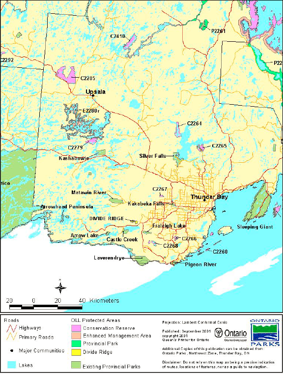
Refer to the maps at the end of the document.
Targets
Life science representation
| Site Type / Landscape Unit |
|
|---|---|
| Species/Communities |
|
Earth science representation
| Geological Theme |
|
|---|---|
| Feature(s) |
|
Cultural resource representation
| Cultural Resource Representation | Remnants of an old homestead with signs of past agricultural practices |
|---|---|
| Theme Segment | Unknown |
Recreational opportunities
| Day Use | Car Camping | Wilderness/Backcountry |
|---|---|---|
|
N/A | N/A |
Inventories
| Level/Type | Reconnaissance/Completion Date | Detailed/Completion Date | Required |
|---|---|---|---|
| Earth Science | February 2002 | No | Yes - Detailed |
| Life Science | February 2002 | No | Yes - Detailed |
| Cultural | No | Bi | Yes - Reconnaissance |
| Recreational | No | March 2002 (target) | No |
| Other | N/A | N/A | Mine hazard survey |
I Introduction
The Divide Ridge Provincial Nature Reserve was recommended as a candidate park in the Thunder Bay District Land Use Guidelines (1983), although it was originally named 'Whitefish Lake-East'. The park was formally established as 'Divide Ridge Provincial Nature Reserve' in 1985, under Ontario regulation 279/85. It was later recommended for expansion as part of Ontario’s Living Legacy (OLL), a land use strategy that guides the planning and management of Crown lands in the central and northern portions of Ontario. Under this initiative, released in July 1999, 378 new protected areas, including the Divide Ridge Nature Reserve Addition (P2274), were identified. On April 6, 2001, the two small parcels of land that made up the addition (303 hectares (ha) in total) were added to the existing nature reserve under Ontario Regulation 85/01. The nature reserve has been regulated under the Provincial Parks Act as 'Divide Ridge Provincial Park (Nature Reserve Class),' although it continues to be referred to as a 'Provincial Nature Reserve.'
The nature reserve classification recognizes the distinctive natural habitats and landforms found in the park, and it is protected for educational purposes and as a gene pool for research to benefit present and future generations. At 542 ha, the nature reserve includes representation of a wide diversity of vegetation types, several earth science themes and a number of provincially significant plant species. It is located just north of Whitefish Lake approximately 60 kilometres west of the City of Thunder Bay.
An Interim Management Statement was first completed for the Divide Ridge Provincial Nature Reserve in 1985 and was later revised in 1991. This Interim Management Statement represents a synthesis of the 1991 version with the new information and management directions that have arisen out of Ontario’s Living Legacy and it replaces the 1991 version.
II Land tenure/Acquisition/Disposition
Divide Ridge Provincial Nature Reserve is composed entirely of Crown Land in the Geographic Township of Strange, District of Thunder Bay. A number of patent properties abut the nature reserve, although there are no patent properties contained within the boundaries. The 1985 boundaries included all of Lot 6, Concession 3, the eastern portion of Lot 7, Concession 3 and the northeastern portion of Lot 7, Concession 2 (see the site map at the end of the document). With the 2001 regulation of the OLL Addition, the following parcels of land were added to Divide Ridge Provincial Nature Reserve:
- northwest portion of Lot 7, Con. 3
- north portion of Lot 8, Con. 3
- north portion of Lots 10 & 11, Con. 3
- the south portion of mining location
footnote 1 Y4 - mining locations Y3 and Y2
- southeast portion of Lot 9, Con. 4
- southeast portion of Lot 10, Con
Guideline:
- No new sales of Crown land for the private use of individuals or corporations will be permitted in a regulated park
- Land dispositions for private or commercial use will not be considered
- If any portions of adjacent patent lands become available they may be considered for addition to the nature reserve
III Aboriginal interests
The Divide Ridge Provincial Nature Reserve is within the Robinson-Superior 1850 Treaty area. Ontario Parks acknowledges that it is also located within the traditional use area of the Fort William First Nation. Although this First Nation is currently negotiating a boundary claim, there are no formal land claims regarding the Divide Ridge Provincial Nature Reserve at this time, as the nature reserve does not fall within their area of concern.
Guideline:
Any management guidelines will reflect the Ontario government’s approach to Aboriginal rights:
- All decisions related to the identification, planning or disposition of provincial park lands, or other lands set aside to protect significant natural or cultural heritage values, will be the subject of public consultation. Aboriginal peoples who identify traditional ties to those lands will be an integral part of the consultation and decision making processes. In some cases there may be a need for separate consultation or negotiation processes to address Aboriginal interest in park lands. If required, some issues regarding how a park is used may also be the subjects of negotiation with Aboriginal
- The Government of Ontario will consider all the available options when seeking to determine the land component, if any, during negotiations involving land claim settlements with First Nations. Options for uses that involve lands not to be considered for provincial park purposes will be
- As described in the Province’s Interim Enforcement Policy (1991), Aboriginal people hunting or fishing in provincial parks will be subject to all relevant treaties and laws. However, an agreement reached between the Province and a First Nation may modify the application of those treaties and laws, 1992).
IV Natural Resource Stewardship
Divide Ridge Provincial Nature Reserve, within the ecodistrict of 4W-2, is characterized by areas of high, flat-topped and densely forested bedrock buttes and their associated talus slopes. The Whitefish River and its floodplains and wetlands lie to the north of this ridge formation. Significant earth science features include Animikie Group (Rove Formation) and Logan Sills (and their associated landforms) and the Animikie Stable Platform and Helikian Keewanawan Rift Valley environments. All of these features are common throughout the region and are found in other parks in the northwest zone, although they are rare in the rest of the province and have been identified as provincially significant.
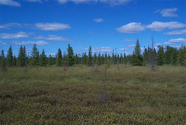
The life science features at Divide Ridge include a cuesta landform consisting of shallow, fine- textured till with mixedwood forest interspersed with rock barren. A cliff and talus community (with the associated provincially rare plants species and alpine-arctic disjuncts), a mature white birch - trembling aspen forest, and the lowland black spruce forest and shore fen found along the Whitefish River are also located within the nature reserve boundaries. With the exception of three provincially significant floral species, the life science features at Divide Ridge are of regional significance.
Lands and waters
Although no lakes occur within Divide Ridge Provincial Nature Reserve, the Whitefish River flows east through the OLL Addition. The river is considered to be a well-developed example of a meandering stream system and would be adversely affected by any alteration to its watershed, flow or sediment load. Wetland features in the nature reserve include a continuous strip of shore fen that occurs along the river and is up to 200 m wide. Black spruce swamp is also found in approximately 40% of the nature reserve.
The Logan Sills and Rove Formation, as well as portions of the Archean basement, are known to be host rocks for amethyst and silver-bearing veins, which suggests that the nature reserve may have some mineral potential. Exploration activities have been conducted in Divide Ridge Provincial Nature Reserve in the past and may have resulted in abandoned mine hazards, such as open trenches and uncapped shafts. A detailed investigation and survey of potential mine hazards has been recommended to take place prior to park management planning. There are presently no mining claims within the nature reserve.
Guideline:
- Commercial hydro development is not permitted
- Peat extraction is not permitted
- Aggregate extraction is not permitted
- Mineral explorations and mining are not permitted within Divide Ridge Provincial Nature Reserve
Vegetation management
Divide Ridge Provincial Nature Reserve contains varied terrain and soil conditions that support a wide diversity of vegetation types in a small area. Shallow loamy-clayey tills are found on the plateau on top of the cuesta and have given rise to jack pine and mixed forests (Ecosite (ES) 19 and ES29) interspersed with lichen-dominated rock barren. The slopes of the cuesta are characterized by rich, shallow, clay-loam soils with aspen and white birch dominated forests (ES29). Disturbance in these forests includes a fire in the 1930s that affected approximately 263 ha, although there has been little recent forest fire. A 1999 windstorm also caused extensive blow-down in about half of the nature reserve and, as a result, the nature reserve is expected to be particularly vulnerable to fire for the next 5-10 years.
The nature reserve also contains a number of provincially and regionally significant floral species and the cold microclimate found along the cliff and talus provides habitat for some arctic-alpine disjuncts. In the vicinity of the building remains (described in Section V – Cultural Resources), introduced and non-native forage grasses have also been found in forest openings, which suggests that the area has been used for pasture.
Divide Ridge Provincial Nature Reserve is located within the Lakehead Forest Management Unit 796, which has been issued to Greenmantle Forest Inc. (Sustainable Forestry License (SFL) no. 542460). This area has a significant harvest history that has resulted in a transition from a predominately conifer/Boreal forest to a boreal hardwood/Great Lakes-St. Lawrence forest. A plantation was established in the mid-1950s in the pre-OLL portion of the nature reserve. In recent years, Greenmantle Forest Inc. has been active in the area. Their planned operations for the 2002-2007 term indicates that there is a salvage operation northwest of the nature reserve as well as on-going renewal and maintenance south and east of Divide Ridge Provincial Nature Reserve.
Guideline:
- Commercial forest operations are not permitted
- Fuelwood cutting is not permitted
- Management will be directed towards on-going natural succession, unless alternative strategies are desirable
- Non-native species will not be deliberately introduced. Where they are already established, and threaten park values, management will develop a program for their eradication
- Insect/disease suppression of non-native infestations is permitted
- In the absence of a fire management plan for the park, the fire management objectives for the surrounding fire zone will apply. All human-caused fires will be suppressed
- Prescribed burning may be permitted, subject to park management planning
- The need for a Vegetation Management Plan, which would include prescriptions for fire management, will be determined in the park management plan
- The locations of significant floral species will not be public information. Necessary measures (access/development restrictions) to protect the integrity of these populations will be implemented
- Ontario Parks will act as a plan advisor and reviewer during the Forest Management Planning Process, according to the Northwest Zone’s Protocol for Ontario Parks' Participation in Forest Management Planning. This process ensures that park values and park-related values are recognized and that protection and mitigation measures are worked out through the development of the forest management plan when these values are potentially effected by adjacent forestry operations
Wildlife and fisheries management
To date, the forest management planning process and the life sciences inventories have not identified specific wildlife values within Divide Ridge Provincial Nature Reserve. Correspondence with local trappers indicates that beavers are frequently trapped along the Whitefish River, suggesting that there is an abundance of aquatic mammals. Moose have also been observed in the area and there are a number of aquatic feeding areas west of the nature reserve. When Divide Ridge was first identified as a candidate park in the mid-1980s, the moose population was estimated to be relatively low and it was considered to have a low wildlife potential. Given the lack of known feeding areas within Divide Ridge Provincial Nature Reserve, these observations have likely remained accurate.
Reconnaissance surveys conducted in the nature reserve recorded over 25 species of birds and more detailed inventories will most likely confirm the presence of additional species. Olive-sided flycatcher and black-throated blue warbler, which are rare in ecodistrict 4W-2, are also believed to nest in the park.
The Whitefish River has been previously described as a cold-water stream and there is anecdotal evidence of the presence of speckled (brook) trout. However, the recent life science reconnaissance survey indicated that it is a warm, sluggish river and that speckled trout are most likely restricted to spring-fed pools. Fisheries-specific surveys have not been conducted on this stretch of the Whitefish River.
Guideline:
- Management will be directed to the maintenance of an evolving natural succession, unless alternative strategies are desirable
- Fish stocking of any kind is not permitted
- Hunting, trapping and fishing by Aboriginal people exercising their Aboriginal or Treaty rights is not affected
- Sport hunting and fishing will be addressed in Section VI – Recreation Activities
- Fur harvesting will be addressed in Section VII – Commercial Activities
V Cultural resources
The cultural resources of the area are largely unknown, although there is a high potential for existing sites. Paleo-Indian archeological sites, that appear to be associated with glacial lakes, have been registered at a number of locations along the ridge north of Whitefish Lake. These sites have all been found at elevations similar to what has been captured within the nature reserve. There are currently no registered archeological sites within Divide Ridge Provincial Nature Reserve.
Building remains have been documented on top of the cuesta in a relatively large clearing and are believed to have been part of an old homestead or logging camp. The main building at this site is still partially intact and the foundation for a second, smaller building is also visible.
Guideline:
- Further inventory is required to assess the cultural resources of the park. Approved archeological fieldwork will be encouraged
- The locations of any archeological sites will not be public information. Necessary measures (access/development restrictions) to protect the integrity of any archeological sites will be implemented
- The need for a Cultural Resources Plan/Strategy for cultural features/sensitive areas will be determined with park management planning
VI Existing/proposed development
There is no primary road development within Divide Ridge Provincial Nature Reserve. At one time, a tertiary road/trail did pass through the middle of what now constitutes the OLL Addition, however, this road is overgrown and is barely visible in the 1992 aerial photographs of the area. The road is still shown on many of the maps of the area, although it can no longer be considered to provide viable access into the park. The Forest Management Plan for the area also depicts a local road board/municipal road that travels north from Highway 588 and terminates in the southwest corner of the pre-OLL nature reserve. A trapper’s cabin, associated with trapline number TB-90, is located in the OLL Addition, in the southwest corner near the Whitefish River.
There is no proposed development for Divide Ridge Provincial Nature Reserve.
Guideline:
- Development of access zones will be addressed via park management planning.
- Ontario Parks' signage is permitted
- Continuing custodial management for roads contained within the park and capital development of new/additional roads will be determined through park management planning
- Development related to snowmobile use will be addressed in Section VII – Recreation Activities
- Development related to fur harvesting will be addressed in Section VIII – Commercial Activities.
VII Recreation activities
Recreation in Divide Ridge Provincial Nature Reserve is limited due to the lack of access (see Section IX – Access), although there is some potential for bird watching, botanical investigations and other forms of nature study. The presence of speckled trout may also provide some angling opportunities for those willing to travel into the nature reserve on foot. The hunting pressure in the area is believed to be quite low, due to a low wildlife potential. There are no existing authorized trails in the pre-OLL or OLL portions of the nature reserve.
The nature reserve is located within Division 21 of the Ontario Recreational Fishing Regulations and, as a result, all the general and area-specific regulations, along with any of the exceptions concerning specific waterbodies, apply to Divide Ridge Provincial Nature Reserve.
Guideline:
- Where compatible with park values, low-intensity day-use activities and facilities that enhance appreciation of the park will be encouraged
- Park management planning will determine policies for recreation management.
- Sport hunting is not permitted
- Sport fishing is permitted, subject to the relevant Ontario fishing regulations
- In accordance with Ontario Provincial Parks: Planning and Management Policies (1992), live baitfish should not be used or possessed in this provincial nature reserve. Until such time as a regulation is established under the Ontario Fisheries Regulations, Ontario Parks will discourage the use or possession of baitfish in this provincial nature reserve
- Mechanized travel (including ATV and snowmobiles) will not be permitted except for access purposes in access zones, as determined through park management planning
VIII Commercial activities
Fur harvesting is an existing commercial activity both within and adjacent to the nature reserve, as trapline TB-90, which has been assigned to a single trapper who operates without any registered helpers, includes a portion of the nature reserve. A trapper’s cabin, associated with this line, was also built within the OLL Addition, prior to its designation as a provincial nature reserve.
There are two Bear Management Areas (BMA) that have some degree of overlap with the OLL Addition. These BMA (TB-13-032 and TB-13-024) have been assigned to two different operators.
The nature reserve also encompasses a portion of baitfish block 4. This block is primarily licensed to one operator. A second operator has been licensed to collect baitfish on selected waterbodies within the block, although these areas are not within the nature reserve boundaries.
Guideline:
- Commercial fur harvesting, including existing trap cabins, will be phased out by December 31, 2009 on the portions of the trap line contained within the nature reserve
- Trapping by First Nations people exercising their Aboriginal or treaty rights is not effected
- Existing authorized BMA licenses will not be renewed or transferred, nor will new operations be permitted, on the portions of the BMA contained within the nature reserve. Ontario Parks will work with the MNR's Thunder Bay District to formally remove the nature reserve from the relevant BMA
- Baitfish harvesting will be phased out by December 31, 2009 on the portions of the baitfish blocks contained within the nature reserve.
IX Access
Access to Divide Ridge Provincial Nature Reserve is very limited, due to the amount of blow-down caused by the 1999 windstorm. The tertiary road that is depicted on many of the maps of the area (see Section VI – Existing/Proposed Development) is not readily identifiable from the air or from the ground, suggesting that it cannot be used as a viable means of access. The local road board/municipal road could provide some access to the nature reserve, although the condition of this road at its terminus is unknown. Water access into the nature reserve is marginal since canoe and boat travel along the Whitefish River is difficult.
Guideline:
- Existing access will be permitted to continue pending park management planning
- No new access to the nature reserve will be created from roads adjacent to the nature reserve until resolved via park management planning
- Decisions on new roads (including upgrading degraded roads), parking facilities and long-tern management of roads abutting/crossing park lands will be clarified via park management planning when access zones are delineated
- Access by Aboriginal people exercising their Aboriginal or Treaty rights is not affected
X Client services
There are currently no client services for the Divide Ridge Provincial Nature Reserve.
Guideline:
- Client services will be limited to a map/brochure until an approved park management plan is completed and all information provided will convey the message that visitors have the responsibility to protect the nature reserve. Development of a Natural Heritage Education Plan will be considered when developing the park management plan
- Recreation programs will not be provided
XI Research and inventories
Reconnaissance earth and life science inventories and a recreation inventory checklist were completed for the nature reserve during summer/autumn 2001. Cultural and historical features have yet to be inventoried.
Guideline:
- Detailed inventories of earth science, life science, cultural and recreation values will be undertaken when funding permits
- Additional research/inventories to document park values will be permitted if not in conflict with park values and consistent with the Ontario Parks Research and Information Strategy
- MNR, Ontario Parks or partnered groups and individuals may undertake research projects. The Park Superintendent/Zone Manager must approve all research applications
XII Marketing
Marketing of Divide Ridge Provincial Nature Reserve has been limited to the acknowledgement of its role in the Ontario’s Living Legacy initiative and the protected areas system, as a whole. The Ontario Parks website also provides a brief description of the nature reserve.
Guideline:
- Any marketing of the nature reserve will focus on its status as a nature reserve and the goals and objectives of this classification
- A park management plan may direct that a detailed Marketing Plan be developed. The scope of this plan would include provincial, national and international markets
XIII Sources/references
Barry, J. 2001. Recreation Inventory Report – Divide Ridge Provincial Park (Nature Reserve Class), Version 1 – December 2001 [Draft]. Ontario Parks, Northwest Zone.
Gauthier, D. 2001. Earth Science Inventory Checklist: Divide Ridge Addition and Existing. Northern Bioscience Ecological Consulting.
Harris, A. and R. Foster. 2001. Divide Ridge (Addition and Existing): Natural Heritage Area – Life Science Checksheet. Northern Bioscience Ecological Consulting.
Ontario Ministry of Natural Resources (OMNR). 2002. Natural Resources Values Information System (NRVIS). Thunder Bay District, OMNR.
OMNR. 1999. Ontario’s Living Legacy Land Use Strategy. Queen’s Printer for Ontario.
OMNR. 1992 (update). Ontario Provincial Parks: Planning and Management Policies.
OMNR. 1985. Divide Ridge Provincial Nature Reserve Interim Management Statement.
OMNR. 1983. Thunder Bay District Land Use Guidelines (DLUG).
Ross, W.A. (Regional Archeologist, Ministry of Tourism, Culture and Recreation). February 11, 2001. Personal communication.
Permitted uses tables for Nature Reserve Class Parks
Existing (Pre-OLL) Nature Reserves footnote 2
Commercial activities
| Activity | Permitted? | Guidelines |
|---|---|---|
| Aggregate extraction | No | |
| Bait fishing (commercial) – existing | Yes | Existing use to be phased out no later than January 1, 2010. |
| Bait fishing (commercial) – new | No | |
| Commercial fishing – existing | No | No licenses exist. |
| Commercial fishing – new | No | |
| Commercial fur harvest – existing | Yes | Existing use to be phased out no later than January 1, 2010, except for trapping by Status Indians enjoying Treaty rights. |
| Commercial fur harvest – new | No | |
| Commercial hydro development | No | New commercial development is not permitted. |
| Commercial timber harvest | No | |
| Commercial Tourism (e.g. outfitting services, outpost camps, resorts/lodges) - existing | No | Park management planning will deal with the need to relocate existing facilities. |
| Commercial Tourism (e.g. outfitting services, outpost camps, resorts/lodges) – new | No | |
| Energy transmission & communications corridors (new) | No | These facilities should avoid park lands wherever possible. |
| Mineral exploration and development | No | |
| Wild rice harvesting - existing | Yes | Existing use to be phased out no later than January 1, 2010, except for harvesting by Status Indians enjoying Treaty rights. |
| Wild rice harvesting - new | No |
Land and resource management activities
| Activity | Permitted? | Guidelines |
|---|---|---|
| Crown land disposition – private use | No | No land disposition for the private use of individuals is permitted. All existing tenure issued by the Crown for private use will be phased out no later than January 1, 2010. |
| Crown land disposition – commercial use | Yes | |
| Fire suppression | No | In the absence of a fire management plan for the park, the fire management objectives for the surrounding fire zone will apply. All human-caused fires will be suppressed. |
| Fish habitat management | No | May be considered through planning. |
| Fish stocking – native species | No | |
| Fish stocking – non-native species | No | |
| Insect/disease suppression | Maybe | May be considered through planning. |
| Inventory/monitoring | Yes | |
| Prescribed burning | Maybe | May be considered through planning. |
| Roads (non-park use) – existing | Maybe | The use of existing roads (i.e., roads currently in use and not previously closed or abandoned) will be determined through planning. |
| Roads (non-park use) – new | No | |
| Vegetation management | Maybe | May be considered through planning. |
| Water control structure – existing | No | No structures exist. |
| Water control structure – new | Maybe | New structures may be considered through planning, but only where the perpetuation of natural features and conditions is a management objective. |
| Wildlife population management | Maybe | May be considered through planning. |
Science, education & heritage appreciation
| Activity | Permitted? | Guidelines |
|---|---|---|
| Demonstration areas | No | |
| Historical appreciation – self guided | Maybe | Support facilities to be identified through planning. |
| Nature appreciation – self guided | Maybe | Support facilities to be identified through planning. |
| Photography and painting | Yes | |
| Research | Yes | Subject to authorization. |
| Wildlife viewing | Maybe | Support facilities to be identified through planning. |
Recreation activities and facilities
| Activity | Permitted? | Guidelines |
|---|---|---|
| Aircraft landing (water) | No | |
| ATV use – on trails | Maybe | No existing authorized trails exist. Use may be permitted in certain zones as determined through planning. |
| ATV use – off trails | No | |
| Camping | No | |
| Horseback riding (trail) | No | |
| Hunting | No | |
| Mountain bike use | No | |
| Motor boat use – private | No | |
| Motor boat use – commercial | No | |
| Non-motorized recreation travel (canoeing, kayaking, hiking, cross- country skiing, snowshoeing) | Maybe | Long-term management direction will be determined through planning. Existing uses may continue in the interim, unless park values are threatened. |
| Private recreation camps ("hunt camps") | No | |
| Rock climbing | No | |
| Sailing and sailboarding | No | |
| Scuba and skin diving | Maybe | Long-term management direction will be determined though planning. Existing uses may continue in the interim, unless park values are threatened. |
| Snowmobiling – on trails | Maybe | No existing authorized trails exist. Use may be permitted in certain zones as determined through planning. |
| Snowmobiling – off trails | No | |
| Sport fishing | Yes | Consult the Ontario Recreational Fishing Regulations Summary for specific local details. |
| Trail development | Maybe | Certain types of trails may be considered though planning. |
Nature Reserve Class OLL additions1
Commercial activities
| Activity | Permitted? | Guidelines |
|---|---|---|
| Aggregate extraction | No | |
| Bait fishing (commercial) – existing | Yes | Existing use to be phased out no later than January 1, 2010. |
| Bait fishing (commercial) – new | No | |
| Commercial fishing – existing | No | No licenses exist. |
| Commercial fishing – new | Yes | Existing use to be phased out no later than January 1, 2010, except for trapping by Status Indians enjoying Treaty rights. |
| Commercial fur harvest - existing | Yes | Existing use to be phased out no later than January 1, 2010, except for trapping by Status Indians enjoying Treaty rights. |
| Commercial fur harvest - new | No | |
| Commercial hydro development | No | |
| Commercial timber harvest | No | |
| Commercial Tourism (e.g. outfitting service, outpost camps, resorts/lodges) - existing | No | No facilities/operations exist. |
| Commercial Tourism (e.g. outfitting service, outpost camps, resorts/lodges) - new | No | |
| Energy transmission & communications corridors (new) | No | These facilities should avoid park lands wherever possible. |
| Mineral exploration and development | No | |
| Wild rice harvesting - existing | Yes | Existing use to be phased out no later than January 1, 2010, except for harvesting by Status Indians enjoying Treaty rights. |
| Wild rice harvesting - new | No |
Land and Resource Management Activities
| Activity | Permitted? | Guidelines |
|---|---|---|
| Crown land disposition – private use | No | No new land disposition for the private use of individuals is permitted, except for minor dispositions in support of existing uses (e.g., reconstruction of a septic system). Renewal of existing tenure for authorized uses is permitted. |
| Crown land disposition – commercial use | No | Existing tourism facilities can continue, and may be eligible for enhanced tenure. Eligibility for enhanced tenure will be determined through management planning. |
| Fire suppression | Maybe | In the absence of a fire management plan for the park, the fire management objectives for the surrounding fire zone will apply. All human-caused fires with be suppressed. |
| Fish habitat management | Maybe | May be considered through planning. |
| Fish stocking – native species | No | |
| Fish stocking – non-native species | No | |
| Insect/disease suppression | Maybe | May be considered through planning. |
| Inventory/monitoring | Yes | |
| Personal use permits for wood harvesting | Maybe | Long-term management direction will be determined through planning. Existing authorized permits may continue on an interim basis for properties that do not have road access. |
| Prescribed burning | Maybe | May be considered through planning. |
| Roads (non-park use) - existing | Maybe | Where existing forest access roads are essential for continued access beyond the nature reserve for forest management or recreation purposes, and alternative road access does not exist, or road relocation is not feasible, existing roads will continue to be available for access. Continued use will include maintenance and may include upgrading. Where other existing access roads are essential for continued access to in-holdings (i.e. LUPs, patent land, etc.) within or beyond the park boundary, and alternative road access does not exist, or road relocation is not feasible, existing roads will continue to be available for access. Continued use will include maintenance. |
| Roads (non-park use) - new | No | |
| Vegetation management | Maybe | May be considered through planning. |
| Water control structure - existing | No | No structures exist. |
| Water control structure - new | Maybe | New structures may be considered, but only for the perpetuation of natural features and conditions, subject to a planning process. |
| Wildlife population management | Maybe | May be considered through planning. |
Science, education & heritage appreciation
| Activity | Permitted? | Guidelines |
|---|---|---|
| Demonstration areas | No | |
| Historical appreciation – self-guided | Maybe | Historical appreciation – self-guided |
| Nature appreciation – self-guided | Maybe | Historical appreciation – self-guided |
| Photography and painting | Yes | Historical appreciation – self-guided |
| Research | Yes | Subject to authorization. |
| Wildlife viewing | Maybe | Support facilities to be identified through planning. |
Recreation activities and facilities
| Activity | Permitted? | Guidelines |
|---|---|---|
| Aircraft landing (water) | No | |
| ATV use – on trails | Maybe | No existing authorized trails exist. Use may be permitted in certain zones as determined through planning. |
| ATV use – off trails | No | |
| Camping | No | |
| Horseback riding (trail) | No | |
| Hunting | No | Existing Bear Management Area licenses will not be renewed. New licenses will not be issued. |
| Mountain bike use | No | |
| Motor boat use - private | No | |
| Motor boat use - commercial | No | |
| Non-motorized recreation travel (canoeing, kayaking, hiking, cross- country skiing, snowshoeing) | Maybe | Long-term management direction will be determined through planning. Existing uses may continue in the interim, unless park values are threatened. |
| Private recreation camps (“hunt camps") | No | |
| Rock climbing | No | |
| Sailing and sailboarding | No | |
| Scuba and skin diving | Maybe | Long-term management direction will be determined through management planning. Existing uses may continue in the interim, unless park values are threatened. |
| Snowmobiling- on trails | Maybe | No existing authorized trails exist. Use may be permitted in certain zones as determined through planning. |
| Snowmobiling- off trails | No | |
| Sport Fishing | Yes | Consult the Ontario Recreational Fishing Regulations Summary for specific local details. |
| Trail development | Maybe | Certain trails may be considered through planning. |
Map: OLL Protected Areas in Divide Ridge Provincial Park & Addition
Site Map: Divide Ridge Provincial Park & Addition (P2274)
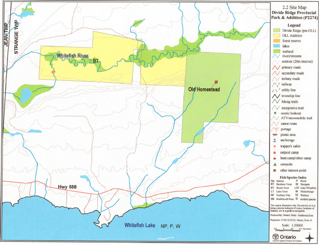
Enlarge Site Map: Divide Ridge Provincial Park & Addition (P2274)
Footnotes
- footnote[1] Back to paragraph The term 'mining location' refers to land that was initially surveyed for mining purposes before the township was subdivided or land in unsurveyed territory. It does not suggest that there are mining claims within the park boundaries.
- footnote[2] Back to paragraph See Section II – Land Tenure/Acquisition/Disposition and the Site Map for written and visual descriptions of the park area, including the delineation between the pre-OLL portion and the OLL Addition