Dubé Creek Iceberg Keel Marks Conservation Reserve Management Statement
This document provides policy direction for the protection, development and management of the Dubé Creek Iceberg Keel Marks Conservation Reserve and its resources.
Statement of Conservation Interest
January 2005
Approval statement
I am pleased to approve this Statement of Conservation Interest for the Dubé Creek Iceberg Keel Marks Conservation Reserve.
The Dubé Creek Iceberg Keel Marks Conservation Reserve was created to protect an area of iceberg keel marks, considered to be a provincially significant earth science feature Ecodistrict 3E-1. Regulated in June 2003, this 1,136 hectare conservation reserve is located in the Territorial District of Cochrane, in Northeastern Ontario and is composed entirely of Crown lands and waters.
Direction for establishing, planning and managing conservation reserves is defined under the PPCRA and associated regulations and guidelines. The specific direction for managing this conservation reserve is in the form of a basic SCI, which defines the area to which the plan applies, provides the purpose for which the conservation reserve has been proposed, and outlines the Ministry of Natural Resources' management intent for the protected area. This Statement of Conservation Interest will provide for the ongoing management of the conservation reserve and the basis for the ongoing monitoring activities. More detailed direction at this time is not anticipated. Should significant facility development be considered or complex issues arise that require additional studies, more defined management direction of special protection measures will be sought and a more detailed Resource Management Plan will be prepared with full public consultation.
The public was informed and consulted prior to the regulation of the Dubé Creek Iceberg Keel Marks Conservation Reserve under the Public Lands Act as well as during the preparation and review of this Statement of Conservation Interest.
The Dubé Creek Iceberg Keel Marks Conservation Reserve will be managed under the jurisdiction of the Ministry of Natural Resources' Hearst District under the supervision of the Hearst District Manager.
Compiled by:
Sarah Munro
Oumar Ka
Chantale Malenfant
Recommended for approval by:
Dave Scott
District Manager
Date: Signed on March 21, 2005
Approved by:
Rob Galloway
Regional Director
Date: Signed on April 10, 2005
Administrative update
Approved by:
Wesley Woods
Hearst District Manager
Date: June 26, 2017
Corrine Nelson
Regional Director
Northeast Region
Date: July 24, 2017
1.0 Introduction
The purpose of this Statement of Conservation Interest (SCI) is to identify and describe the values of the Dubé Creek Iceberg Keel Marks Conservation Reserve. The SCI also outlines activities that occur within the conservation reserve and provides guidelines for the management of current and future activities in the context of protecting the natural and cultural values within the reserve.
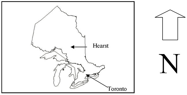
The site, 1,153 hectares in size, is located west of the town of Hearst and east of the Kabinakagami River, in Irish Township (Map 1). The Dubé Creek Iceberg Keel Marks Conservation Reserve includes a complex of linear, furrow-like marks that were formed by icebergs floating in Glacial Lake Ojibway. Moved by winds and currents, the base or keel of these icebergs contacted the soft lake bottom sediments creating these linear, furrow-like depressions. The vegetation is characterized by the extensive black spruce (Picea mariana) communities, which are represented by three different developmental stages including old growth.
Management direction specified in this SCI will serve to protect the conservation reserve for the benefit of all Ontario residents. This direction will comply with the land use intent stated in the Ontario’s Living Legacy Land Use Strategy (LUS) (OMNR 1999) and associated policy clarification statements (OMNR 2000). Additionally, this conservation reserve will be managed under the the Provincial Parks and Conservation Reserves Act, 2006 (PPCRA).
1.1 Provincial context
On July 16, 1999, the Ontario Government released the LUS to guide the planning and management in central and parts of northern Ontario. The LUS focuses on four specific objectives that were established to guide the planning process:
- completing Ontario’s system of parks and protected areas
- recognizing the land use needs of the resource-based tourism industry
- providing forest, mining, and other resource industries with greater land and resource use certainty
- enhancing angling, hunting and other Crown land recreation opportunities
The first objective was accomplished in part through the designation of new conservation reserves and provincial parks, and additions to existing provincial parks. The Dubé Creek Iceberg Keel Marks Conservation Reserve (C1531) is part of this expansion of Ontario’s protected areas system.
Conservation reserves complement provincial parks in protecting representative natural areas and special landscapes. Most recreational (e.g. hiking, skiing, tourism, related uses and nature appreciation) activities that have traditionally been enjoyed in the area will continue, provided that these uses do not impact on the natural features needing protection. Hunting and sport fishing are permitted within all new conservation reserves proposed through the LUS.
2.0 Goals and objectives
2.1 Goal of the Statement of Conservation Interest
The goal of a conservation reserve is to protect the natural heritage values on public lands while permitting compatible land use activities. This SCI will provide a framework to guide the management direction for the Dubé Creek Iceberg Keel Marks Conservation Reserve and meet this goal through short and long-term objectives.
2.2 Short term objectives
The three short-term objectives are addressed with the development of this SCI:
- To describe the current state of the resource including natural heritage values and current land use activities for the Dubé Creek Iceberg Keel Marks Conservation Reserve
- To protect the integrity of the natural values within the Dubé Creek Iceberg Keel Marks Conservation Reserve through the specific guidelines, strategies and prescriptions detailed in this Statement of Conservation Interest
- To meet planning requirements (e.g. the development of this SCI)
2.3 Long term objectives
The three long-term objectives highlight some of the future work associated with this site.
- To establish representative targets and validate the Dubé Creek Iceberg Keel Marks Conservation Reserve as a potential scientific benchmark
- To identify research opportunities, client services, marketing strategies and partnership opportunities to promote the Dubé Creek Iceberg Keel Marks Conservation Reserve and the Hearst area
- To provide direction to evaluate new uses or economic development ventures, including details within this document and applying the Test of Compatibility to evaluate potential impacts of new uses (Appendix A).
3.0 Management planning
3.1 Planning process
A Conservation Reserve is a protected area designation that is regulated under the PPCRA. This designation permits many traditional land uses to continue while excluding activities such as commercial timber harvest, mining and hydro electrical development.
The Dubé Creek Iceberg Keel Marks Conservation Reserve was originally proposed as an earth science site C5 (Ritchie and Thompson 1998) and presented in the LUS as site C1531 (OMNR 1999). Public consultation was undertaken in September 2000 (Appendix B)
The site was regulated under the Public Lands Act on May 21, 2003 (O. Reg. 208/03) and subsequently regulated under the PPCRA (2006) by Ontario Regulation 315/07 on June 9, 2008.
There are two types of documents that can be produced to direct the management of conservation reserves in Ontario a Statement of Conservation Interest (SCI) or a Resource Management Plan (RMP). SCIs fulfill the minimal requirement for providing management direction while RMPs are used to deal with more complex issues (OMNR 1997b). If major issues arise during the development of an SCI and a need to make decisions beyond the direction provided in the Land Use Strategy (OMNR 1999) is identified an RMP will be developed. As with the majority of conservation reserves, a decision has been made to develop a SCI to lend management direction for the Dubé Creek Iceberg Keel Marks Conservation Reserve.
First Nations and the general public were notified of management planning for this and five other conservation reserves in the Hearst District through newspaper advertisements and a mail out in December 2004. There were 17 responses to these notices. The public was notified in February, 2005 and given an opportunity to review the draft SCI. One comment was received.
Any future proposals or significant changes in management direction will be done with full public consultation including a posting on the Environmental Bill of Rights Registry.
3.2 Planning area
This SCI applies only to the area within the regulated boundary. The MNRF will continue to work with adjacent land managers to promote and protect the natural and cultural values of this conservation reserve.
4.0 Background information
4.1 Site location
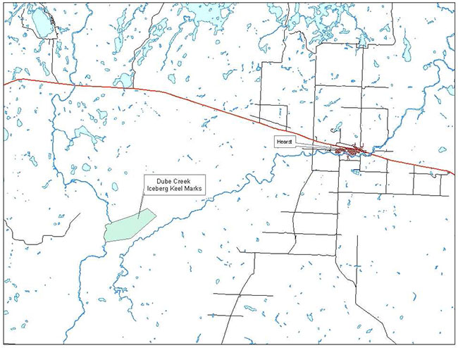
The Dubé Creek Iceberg Keel Marks Conservation Reserve is located approximately 25 kilometres southwest of the town of Hearst, in Irish Township (Map 1). The western border of the conservation reserve is formed by Kabinakagami River and the Mattawishkwia River is located 1 kilometer south of the site.
The conservation reserve can be accessed from the Kabinakagami River, south of Highway 11, or from forest access roads.
There are no known roads or trails within the conservation reserve. Access to the boundary of the site is limited to forest harvest roads and the Kabinakagami River. Harvesting adjacent to the site is ongoing (Hearst Forest Management Inc. 2002).
4.2 Physical site description
The Dubé Creek Iceberg Keel Marks Conservation Reserve is located on the western boundary of the Cochrane Ecodistrict 3E-3 and extends in to the Hornepayne Site District 3E-2 (Hills 1959). The Ecodistrict boundaries have recently been revised and the conservation reserve now falls within the Smokey Falls Ecodistrict 3E-1 (Crins 2000). The Smokey Falls Ecodistrict (3E-1) is characterized by a smooth plain of clay and loam, moderate to high in lime, shallow to moderately deep over bedrock with a fairly high percentage of muskeg.
The Smokey Falls Ecodistrict is found within a larger area called the Lake Abitibi Ecoregion 3E, which is characterized by flat to gently rolling, glacial clay and sand plain with locally extensive peatlands and wetlands, broken throughout by glacial features such as moraines, eskers and kame and kettle complexes with Canadian Shield exposures (Hills 1959).
The conservation reserve falls in the Moose River Basin, within 4JA and 4LK tertiary watersheds (Thompson et alt 2003). The only major waterway found in the conservation reserve is the Kabinakagami River, which acts as the boundary for the western part of the site. The site also contains Dubé Creek, in the western part of the reserve.
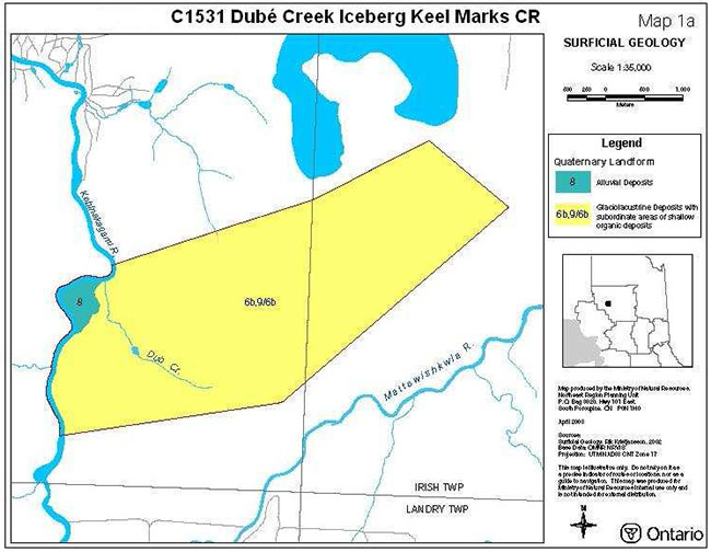
An extensive area of fine-grained, glaciolacustrine deposits (silt and clay) dominate the surficial geology of the conservation reserve with smaller areas of shallow organic deposits. This is supported by Crosbie (1980) who indicates that most areas of fine-grained, glaciolacustrine deposits associated with the Kabinakagami River and the Mattawishkwia River are covered by shallow organic deposits.
The Dubé Creek Iceberg Keel Marks Conservation Reserve is within the Northern Clay Section of Rowe’s (1972) Boreal Forest Region. The Northern Clay Section is characterized by widespread black spruce stands on both the gently rising uplands and the lowland flats coexisting with sedge fens and sphagnum-heath bogs. Tamarack is occasionally found with black spruce and is more common in younger stands. Extensive areas of black spruce-cedar swamp occur more commonly in the western portion of this section. Areas with improved drainage contain hardwood or mixedwood stands of trembling aspen, balsam poplar, balsam fir, white spruce and black spruce. Drier areas such as old beaches, eskers, and outwash deposits are dominated by stands of jack pine and white birch.
The forest climate for this site is mid-humid, mid-boreal (Hills 1959, Poser 1992). The Hearst area receives a minimal annual precipitation of 79 centimeters and 2.79 metres of snow. On average there are 90 frost free days in the Northern Clay Belt resulting in a growing season of approximately 160 days.
Table 1: Location and administrative details for the Dubé Creek Iceberg Keel Marks Conservation Reserve
| Name | Dubé Creek Iceberg Keel Marks Conservation Reserve |
|---|---|
| Total Area (hectares) | 1,136 ha |
| Eco-Region / Eco-District (Hills 1959) | 3E- 3E-3 / 3E-2 |
| Eco-Region / Eco-District (Crins 2000) | 3E-Smokey Falls / 3E-1 |
| MNRF Administrative Region District Area | North East Region Hearst District Hearst Area |
| Forest Management Unit | Hearst Forest |
| Watershed | Moose River Basin within 4JA and 4LK tertiary watersheds |
| Wildlife Management Unit | 22 |
| Nearest Town | Hearst |
| Townships | Irish |
| Regulation Date | June 2003 |
| UTM Reference | 283550 (Zone 17) |
4.3 Administrative description
The legal description of the Dubé Creek Iceberg Keel Marks Conservation Reserve, regulated as Schedule 174 in Ontario Regulations 208/03 made under the Public Lands Act on May 21, 2003 and published on June 7, 2003 amending Ontario Regulation 805/94, reads:
In the geographic Townships of Irish, in the Territorial District of Cochrane, containing 1,136 hectares, more or less, being composed of that part of the said township designated as Part 1 on a plan known as C1531 Dubé Creek Iceberg Keel Marks Conservation Reserve, filed on February 14th, 2003 with the Office of the Surveyor General of Ontario in the Ministry of Natural Resources.
The conservation reserve is located within the Ministry of Natural Resources, Hearst District and within the legal boundaries of the Hearst Forest Sustainable Forest Licence.
4.4 History of the site
The iceberg keel marks were formed during the last glaciation that reached its peak between 15,000 and 23,000 years ago. Icebergs floating on glacial Lake Ojibway were moved around by winds and currents. As they moved the base, or keel, of the iceberg contacted the soft lake bottom and created furrow-like depressions. These depressions are known as keel marks and in the case of those at Dubé Creek are up to 1.7 kilometres in length.
Hearst, the nearest town, is located approximately 25 kilometres northeast of the site. The town, established in 1913, has relied on the rail road, agriculture and more recently forestry.
There are no known roads or trails within the site and access to the conservation reserve is limited to the Kabinakagami River. However, the current forest management plan for the Hearst Forest outlines harvesting activities and associated roads adjacent to the reserve during the 2002-2007 operating period.
4.5 Inventories
Inventory conducted to date as well as future priorities for inventory are outlined in Table 2.
Table 1: Inventory information for Dubé Creek Iceberg Keel Marks Conservation Reserve
| Survey Level | Earth Science | Life Science | Cultural | Recreational | Other |
|---|---|---|---|---|---|
| Reconnaissance | 2003 (Kristjansson) Aerial Photo Interpretation Geological mapping | 2003 (Thompson et al) Aerial | Aerial | ||
| Detailed | Not required | Not Required | Not required | Not required | |
| Further Requirement | None | None | Ground reconnaissance |
5.0 State of the resource
The goal of the Natural Heritage Areas Program is "to establish a system of protected natural heritage areas, representing the full spectrum of the province’s natural features and ecosystems" (OMNR 1997c). The natural heritage of Ontario contributes to the economic, social and environmental well being of the province and its people. Protecting areas of natural heritage is important for many reasons such as maintaining ecosystem health and providing a range of habitat in order to maintain species diversity and genetic variability. Protected areas also provide scientific and education benefits, they can generate tourism and provide places where people can enjoy and appreciate Ontario’s natural diversity while enhancing their own health and well-being. In order to protect this vital natural heritage, Ontario has established a provincial parks and protected areas system to try to represent the entire suit of natural features and ecosystems within the province. This representation and the criteria used to determine the current quality of that representation are detailed below (OMNR 1997c).
5.1 Representation
Ontario’s natural heritage areas system is meant to protect representative samples of Ontario’s natural and cultural diversity. The LUS (OMNR 1999) describes the Dubé Creek Iceberg Keel Marks Conservation Reserve as a complex of linear, furrow like marks formed by icebergs floating in glacial Lake Ojibway. The conservation reserve was chosen as an earth science site for its representation of provincially significant iceberg keel marks.
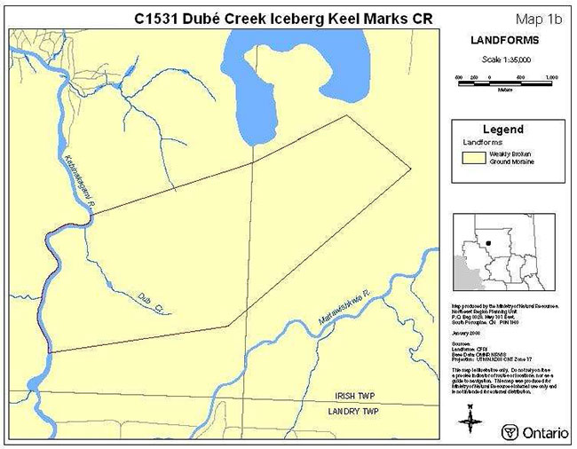
According to the provincial landform coverage, the site is entirely composed of weakly broken ground moraine. Kristjansson (2003) interpretation differs from the provincial landform coverage for this site. He indicates that there is a strong presence of iceberg keel marks in association with southeast-oriented drumlinoidal ridges and flutes. Two small areas of bedrock-drift complex and a small area of organic deposits are also located within the southern portion of the conservation reserve. The site is immediately underlain by an extensive area of glaciolacustrine deposits with smaller area of shallow organic deposits and a minor area of alluvial deposits occurring in the northwest corner of the site along Kabinakagami River (Kristjansson 2003). This interpretation is based on aerial reconnaissance survey, review of surficial geology maps and aerial photo interpretation.
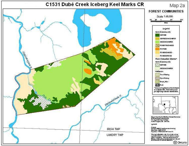
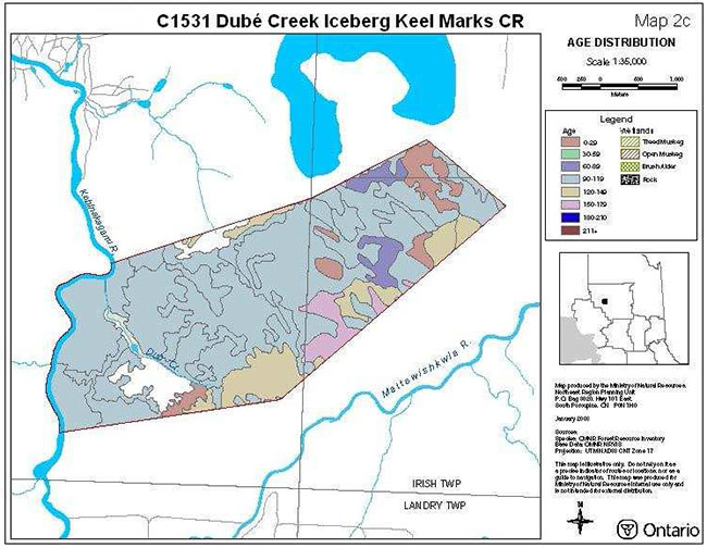
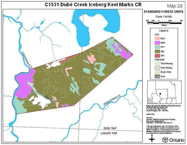
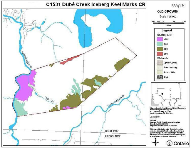
Black spruce communities cover more than three-quarters of the conservation reserve. These communities range from pure stands, to predominant conifer and dominant conifer stands. The poplar (Populus tremuloides) communities range from pure stands, to hardwood mixed, mixed wood and poplar/black spruce mixed stands, which are located along the Kabinakagami River, along the northeastern boundary of the site and in the southern part of the reserve (Map 2d – Standard Forest Units). The majority of these forest communities are aged between 90-119 years, which includes some of the poplar old growth found within the site. The remaining old growth species within the site are black spruce communities aged between 120-149 and 150-179 years (Map 2c – Age Distribution).
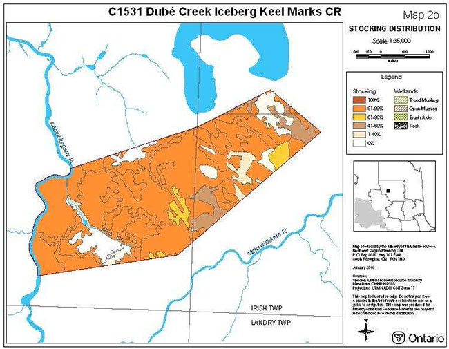
The Dubé Creek Iceberg Keel Marks Conservation Reserve is highly stocked with the majority of the stands stocked between 81-99 percent.
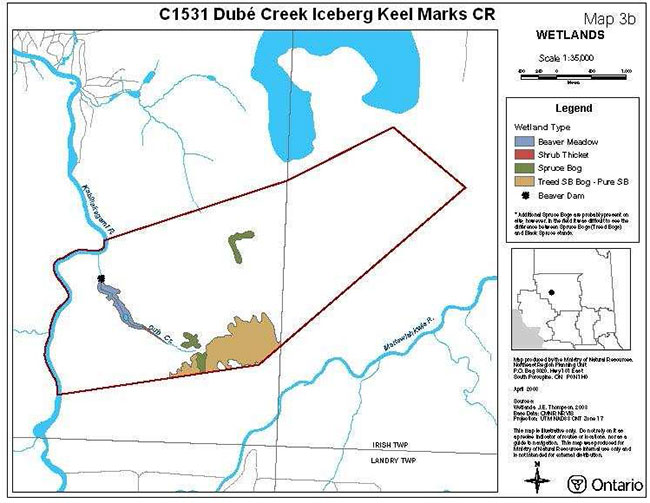
Wetlands are present within the reserve (Map 3b - Wetlands). A beaver dam at the top of Dubé Creek in the northern part of the site has changed the normal pattern of the shore fen into a rather large beaver meadow which narrows down to alder thickets. A number of spruce bogs can be found throughout the site.
5.2 Quality of representation
The quality of the representation or the current characteristics of the natural features found within the conservation reserve are as important as the overall representative features that are being protected. A number of factors are considered in evaluating a site including: diversity, condition, special features, ecological factors and current land use activities.
Diversity
Diversity is the measure of the relative number and range (i.e. amount of richness and evenness) of vegetative communities or special features found within the conservation reserve. Natural landscapes and known generalized vegetative communities will be the scale used for this SCI. Future aerial or ground reconnaissance surveys will enhance the MNRF's knowledge of these features and possibly allow verification at a lower scale (e.g. species assemblages).
The Dubé Creek Iceberg Keel Marks Conservation Reserve is considered to have low diversity. This is based on the small size of the site, the low number of landform/vegetation combinations, and that the conservation reserve is dominated by one forest community - black spruce. There are 6 landform/vegetation combinations within the Dubé Creek Iceberg Keel Marks Conservation Reserve.
Ecological factors
Ecological factors refer to the current design of the conservation reserve as noted by its size, shape, and buffering capacity to adjacent land use activities. In addition a site’s linkage to undisturbed landscapes also contributes to the conservation reserves ecological integrity.
The Dubé Creek Iceberg Keel Marks Conservation Reserve is mostly contained by vectored boundaries. The site’s northern, eastern and southern boundaries are all vectored with Kabinakagami River acting as the biological western boundary of the reserve. Due to the predominance of vectored boundaries, most of the site’s vegetative communities are dissected leaving these stands with little to no core areas. This makes it much harder to protect these communities. These fragmented forest communities also provide limited buffering for the site’s interior core values.
The small size, 1,136 hectares, the vectored boundaries and adjacent forest harvesting may inhibit this site’s ability to maintain its core values over the long term.
Condition
Condition is the amount of disturbance, man-made or natural, within a conservation reserve. The disturbance of the Dubé Creek Iceberg Keel Marks Conservation Reserve is rated as low.
The aerial reconnaissance survey considered this site to be in excellent condition with very little disturbance. Evidence of past clear cutting activities was observed outside of the site to the west, east and far north with some harvesting crossing over the Kabinakagami River into the site. However, the cut area in the site has since regenerated from poplar to balsam fir, cedar and black spruce leaving very little disturbance in the site. There are no visible roads or trails within this conservation reserve.
Special features
Special features include interesting landscapes, habitats or vistas, species at risk and other earth and life science features including broader landscape elements that contribute to the natural heritage richness of Ontario.
The special features for this site include the provincially significant iceberg keel marks found throughout the conservation reserve and the extensive black spruce communities, which are represented by three different developmental stages including old growth.
Current land use activities
The conservation reserve falls within one trapline. Limited access to the exterior and interior of the site has resulted in relatively limited use of the area. Hunting, fishing, canoeing and boating may be occurring in the site.
There are no known facilities or structures within the conservation reserve.
5.3 Linkages to local communities
The Dubé Creek Iceberg Keel Marks Conservation Reserve has no known trails within the site and limited access up to the boundary. Primary access can be gained from the Kabinakagami River south of Highway 11. Roads resulting from adjacent forest management activities may offer increased access to the site. Some recreational activities that the Dubé Creek Iceberg Keel Marks Conservation Reserve represents may include bird watching, wildlife viewing, photography, fishing, small and large game hunting and trapping. Hunting, trapping and fishing are long-standing traditional activities and are a vital part of the local economy. Economic benefits are seen at local establishments from hunting parties as well as fishing enthusiasts.
5.4 Aboriginal interests
The Dubé Creek Iceberg Keel Marks Conservation Reserve falls within the area of the Nishnawbe-Aski Nation (NAN) and Treaty #9. The nearest First Nation is Constance Lake First Nation which is located 30 kilometres to the west of the site. The protection of this area as a conservation reserve and this SCI are not meant to infringe on the Treaty and Aboriginal Rights of any First Nations. Aboriginal peoples have existing Aboriginal or Treaty Rights that are protected under the Constitution of Canada. The Ontario government is consulting with Aboriginal Peoples concerning decisions that may affect the use of Crown land and resources that are subject to Aboriginal or Treaty Rights. The consultation for this document is an attempt to ensure these existing obligations are not restricted. MNRF's existing planning processes provide opportunities for all citizens to participate in planning for natural resources under MNRF's administration. However, it is recognized that more effective approaches are required in order to consult effectively with Aboriginal peoples.
Traditional activities such as hunting, fishing and trapping and gathering will be respected. At present time, there are no known land claims by First Nations for the area in question.
5.5 Natural heritage values
The Dubé Creek Iceberg Keel Marks Conservation Reserve contributes to the province’s parks and protected areas system through its regulation, representation and the long-term management of its natural heritage values.
The protected areas system allows for permanent protection of our history and special features, and it will provide valuable areas as benchmarks to scientist and educators. Each protected area contributes to this heritage in its own unique way, whether it is a contribution to the preservation of an earth science value, a life science value, a recreational or economic opportunity, or through its cultural and historical significance. The designation of an area as a conservation reserve helps define its role in the system.
The Dubé Creek Iceberg Keel Marks Conservation Reserve was designated to protect provincially significant iceberg keel marks (Ritchie and Thompson 1998). The site also protects extensive black spruce communities in three different developmental stages, including old growth (Map 5 – Old Growth) (Thompson et al. 2003).
Long term management must consider public access to the site, the conservation reserve protection objectives, and commitments made in the LUS (OMNR 1999).
5.6 Mining interest
This conservation reserve has no mining tenure within it. Mining and surface rights have been withdrawn form staking within the conservation reserve boundaries under the Mining Act (RSO 1990 Chapter M.14).
5.7 Forest and fire management history
A small portion of the conservation reserve has been harvested; however it has since regenerated to balsam fir, white cedar and black spruce (Thompson et al. 2003). The conservation reserve has not recently been affected by forest fires.
5.8 Government agencies interests
Departments, Crown Corporations and other government agencies that may have an interest in this site may include the Ministry of Tourism, Culture and Sport (MTCS). Local government bodies may include Constance Lake First Nation, and the Town of Hearst.
Although there are no know cultural heritage values present, if values are identified the MNRF would work with the MTCS and local First Nation communities to ensure proper protection of any cultural heritage resources.
5.9 Non-government organizations and other industry interests
Non-government organizations who may express an interest in the Dubé Creek Iceberg Keel Marks Conservation Reserve could include: the Hearst Trappers Council, Hearst Anglers and Hunters, the Partnership for Public Lands, the Federation of Ontario Naturalist, Northern Ontario Tourist Outfitters, and the Ontario Federation of Anglers and Hunters.
The existence of this protected area will provide enhanced recreation potential and these associations may wish to approach the MNRF as stewards of the conservation reserve. The MNRF will work in conjunction with any association who identifies an interest in exploring compatible use or development within the site.
Other industries or companies that may have an interest in the conservation reserve includes the Prospector’s Association, the Sustainable Forest Licence Holder (Hearst Forest Management Inc.), and the Aggregate Producer’s Association. The interests of these groups may be limited to recognizing the boundaries and the values protected within the site in order to uphold the MNRF's management policies within the conservation reserve.
5.10 Fisheries and wildlife
The Dubé Creek Iceberg Keel Marks Conservation Reserve falls within Wildlife Management Unit 22 and Fisheries Division 19.
Fishing opportunities are high in the general area of the conservation reserve due to the proximity of two major rivers – the Kabinakagami and the Mattawishkwia Rivers.
The wildlife that could be found within the site would be consistent with typical wildlife found in Ecodistrict 3E-1 including birds, small furbearers and large ungulates. The conservation reserve is located within one trapline.
It is not known if any vulnerable, threatened or endangered species exist on or near the site. Further detailed habitat studies may be warranted.
5.11 Cultural heritage values
There are no known cultural heritage values within the Dubé Creek Iceberg Keel Marks Conservation Reserve and to-date there has been no assessment of cultural resources. The potential of cultural resources is high given its close proximity to two major rivers.
The MNRF will continue to work with the Ministry of Culture and local First Nations to identify archaeological sites, which should be protected.
5.12 Current land use and development
This conservation reserve rest entirely on Crown land and is unencumbered by any land use permits, licences of occupations, leases or mining claims. There is no mining tenure near the site and no mines have been developed on the site in the past.
There are no existing facilities in the conservation reserve.
5.13 Current commercial use
Current commercial use is limited to commercial fur harvesting.
5.14 Current recreation use and opportunities
Recreation uses currently occurring in the general area of the conservation reserve include wildlife viewing, camping, fishing, hunting, and canoeing.
5.15 Current client services
Current visitor services offered by the Hearst District MNRF are limited to the basic level of information such as access, natural heritage features, and boundary location.
6.0 Management guidelines
The land use intent outlined in the LUS (OMNR 1999) and the PPCRA provides the context and direction for land use, resource management, and operational planning activities on Crown land. Commitments identified in the above strategy and current legislation (OMNR 1997a) will form the basis for land use within the Dubé Creek Iceberg Keel Marks Conservation Reserve. These management strategies will maintain, protect and enhance the existing natural heritage values and land use activities of the Dubé Creek Iceberg Keel Marks Conservation Reserve. For up to date information on permitted uses refer to the Crown Land Use Policy Atlas (Appendix B – Crown Land Use Atlas Policy Report).
Protected areas will be managed to retain and/or restore natural features, processes and systems. They will also provide opportunities for compatible research, education and outdoor recreation activities (OMNR 1997c). Proposed uses and development will be reviewed on a case-by-case basis. A Test of Compatibility must be passed before they are deemed acceptable within the conservation reserve (Appendix A). The emphasis will be on ensuring that the natural values of the conservation reserve are not negatively affected by current and future activities.
Management strategies will also be consistent with the objectives of promoting responsible stewardship and identifying monitoring opportunities.
6.1 Sensitive features
The wetland vegetation, located in the south west of the site, is moderately sensitive to development. The nature and season of the activities in this area should be considered when assessing potential impacts on this feature.
The potential for erosion and gullying of the fine-grained sediments which underlie the iceberg keel marks following the removal or alternation of the vegetation cover is considerable. This is to be considered with any proposed development.
6.2 Aboriginal interests
The Dubé Creek Iceberg Keel Marks Conservation Reserve falls within the area of the Nishnawbe-Aski Nation (NAN) and Treaty #9. The nearest First Nation is Constance Lake First Nation which is located 30 kilometres to the west. The protection of this area as a conservation reserve and this SCI are not meant to infringe on the Treaty and Aboriginal Rights of any First Nations. All Aboriginal and Treaty Rights will continue to be respected. First Nation communities are encouraged to continue to use these areas as they have in the past.
6.3 Industrial activities
Industrial activities such as; timber harvesting, prospecting, mining, removal of aggregates or peat and new hydro generation will not be permitted within the boundaries of this conservation reserve.
6.4 Existing and proposed development
Utility corridors
Energy transmission, communication and transportation corridors, and construction of facilities are discouraged within the boundaries of the conservation reserve. Alternatives should be reviews via larger landscape planning processes.
Roads and trails
New roads for resource extraction and or private use will not be permitted.
No trails have been identified within the conservation reserve. Under the LUS (OMNR 1999), all mechanized travel is restricted to existing trails. Off trail use is permitted for the retrieval of game only. New trails can be considered through planning and would be subject to a "Test of Compatibility"
Land disposition
The sale of lands will not be permitted within the conservation reserve (OMNR 1999), except for those situations described in the policy clarification tables (OMNR 2000).
There are no Land Use Permits with in the conservation reserve. New Land Use Permits may be considered for approved activities, subject to a Test of Compatibility (Appendix A) and applicable policies and procedures.
Tourism facilities
The earth and life science features and their protection shall be the overall theme for tourism and recreation within the conservation reserve. There are no existing tourism facilities located in or directly adjacent to this conservation reserve. Any proposed tourism infrastructure or facilities would be required to undergo a Test of Compatibility to ensure that the activity is consistent with permitted uses for conservation reserves and that natural heritage values within the site are protected. If new development is considered appropriate public consultation would be conducted and this SCI would be amended.
6.5 Resource management activities
The conservation reserve will be managed by allowing natural ecosystems, processes, and features to function with minimal human interference. All earth and life science feature will be protected by defining compatible uses, enforcing regulations and monitoring and mitigating issues.
Fire management
The MNRF recognizes fire as an essential process fundamental to the ecological integrity of conservation reserves. Fire Protection will be carried out in accordance with The Wildland Fire Management Strategy (2014), which provides direction for how the MNRF manages wildland fire across Ontario
Whenever feasible, the MNRF fire program will endeavor to use "light on the land" techniques, which do not unduly disturb the landscape, in this conservation reserve. Examples of light on the land techniques include limiting the use of heavy equipment or limiting the number of trees felled during fire response efforts. Opportunities for prescribed burning to achieve ecological or resource management objectives may be considered. These management objectives will be developed with public consultation prior to any prescribed burning, and reflected in this SCI. Plans for any prescribed burning will be developed in accordance with the Wildland Fire Management Strategy (2014) and the Class Environmental Assessment for Provincial Parks and Conservation Reserves (OMNR 2005).
Vegetation management
The introduction of exotics and/or invasive species will not be permitted. Programs may be developed to control forest insects and diseases in the conservation reserve where these threaten significant heritage, aesthetic, or economic values. Where control is desirable, it will be directed as narrowly as possible to the specific insect or disease. Biological control will be used wherever possible.
The collection or removal of vegetation and parts thereof will not be permitted. However, subject to a Test of Compatibility, the District Manager may authorize the collection of plants or parts of plants for the purposes of wild rice harvesting, food harvesting, removing exotic species, rehabilitating degraded sites within the reserve, collecting seeds for maintaining genetic stock, inventory or research. The cutting of trees for non-commercial purposes (e.g. fuel wood) is not permitted.
Fisheries and wildlife management
Fish and wildlife resources will continue to be managed in accordance with policies and regulations prevailing in the area, under the direction of the Hearst District Manager. Provincial legislation and policies will dictate management and enforcement objectives for this conservation reserve.
6.6 Commercial activities
Trapping, baitfish harvesting and Bear Management Areas
Commercial, non-industrial, activities such as trapping, baitfish harvesting and Bear Management Areas will be managed according the prescription in the LUS (OMNR 1999). Traplines and bait fishing operations can be renewed and transferred. New operations would be subject to a Test of Compatibility to ensure that wildlife populations could sustain additional activities (Appendix A). Existing Bears Management Areas will be permitted to continue; new operations will not be permitted. MNRF will work with operators to ensure that the natural heritage values within the conservation reserve are respected.
Commercial food harvesting
Currently no commercial food harvesting exists within the conservation reserve. Such ventures may be considered, subject to a Test of Compatibility (Appendix A) and applicable policies and procedures.
Commercial tourism
Existing tourist outfitters can continue to access this reserve as they have in the past. Currently there are no outpost camps within the reserve. New outpost camps may be considered, subject to a Test of Compatibility (Appendix A) and applicable policies and procedures. These camps would be under Land Use Permits, sale of Crown land for new outpost camps will not be permitted.
MNRF with continue to work with proponents to ensure the values of the conservation reserve are respected and maintained to the highest level possible.
6.7 Non-commercial activities
Recreation activities
Most recreational activities that have traditionally been enjoyed in the area can continue, provided the activity poses little or no threat to the natural ecosystem and features protected by the reserve. Current activities include bird watching, hunting, and canoeing. Camping may also be a current use in the conservation reserve and will be permitted to continue.
Hunting and sport fishing
Hunting and sport fishing will be permitted within this conservation reserve in accordance with policies and regulations prevailing in the area, under the direction of the Hearst Area Supervisor.
Motorized access
No roads or trails have been identified within the conservation reserve. Vehicles will be permitted on existing roads within the conservation reserve. Snowmobiles and ATVs will be permitted on existing roads and trails. Off trail use is permitted for game retrieval only (OMNR 2000).
6.8 Client services
Clients indicating their interest in the management, planning and future use of the conservation reserve will be put on a mailing list and notified of any future planning initiative for the site.
Client services will be provided at the Hearst District Office. MNRF Hearst District office will be the lead agency for responding to inquiries regarding access, permitted and restricted activities, values information and recreation opportunities. A management agreement may be pursued with an appropriate partner to share responsibilities for information services and the delivery of other aspects of this SCI.
Marketing efforts to increase use are not a priority and will be kept to a minimum.
6.9 Monitoring and research
Scientific research by qualified individuals, which contributes to the knowledge of natural and cultural history and to environmental and recreational management, will be encouraged. All research programs require the approval of the MNRF and will be subject to ministry policy and other legislation. Those interested in pursuing research within the conservation reserve must apply to the Area Supervisor for approval. Applications to complete the research will follow guidelines established by Ontario Parks for research within provincial parks or equivalent direction formulated by the Hearst District. Approvals will meet all terms and conditions established by the MNRF Hearst District Office.
Additional earth science and cultural surveys are required to refine values and management guidelines. These may be done as resources are made available. Research related to the study of natural processes will also be encouraged provided it does not harm the values of the reserve.
The ministry may approve on a case by case basis the removal of any natural of cultural specimen by qualified researcher. All such materials removed remain the property of the MNRF.
Approved research activities and facilities will be compatible with the protection objective. Permanent plots or observation stations may be established to which researchers can return over time. Any site that is disturbed will first go through a Test of Compatibility and will be rehabilitated as closely as possible to its original state.
Particular research may focus on the interrelationship with other nearby protected areas – in particular to gauge the effectiveness of small, isolated protected areas and how such sites need to be connected through supportive landscape management in order to maintain ecosystem health and diversity. The effects of straight boundaries versus naturally delineated boundaries should be explored. Further research and monitoring requirements will be determined through forthcoming regional and provincial strategies.
7.0 Recommendations and future needs
The following recommendations have resulted from inventory work and the development of this SCI.
- A more detailed life science checksheet should be completed as funding permits (a step 5)
- This more detailed life science information should be analyzed with the new landform information and regulated boundary to determine more fully the site’s significance and contribution to the parks and protected areas system
- Additions to this conservation reserve should consider improving the design of the site to enhance core features (i.e. use of natural boundaries). Additions to this conservation reserve should only occur if a vegetative rehabilitation plan is funded in the near future.
- The boundary should be delineated
- The site should be reviewed as a potential monitoring/research site if access is improved
8.0 Implementation and plan review
The Dubé Creek Iceberg Keel Marks Conservation Reserve SCI will be examined, as per the schedule outlined in the PPCRA. Implementation of the SCI and management of the reserve are the responsibility of the Hearst Area Supervisor.
If changes in management direction are needed at any time, the significance of the changes will be evaluated. Administrative updates to the SCI may be considered and approved by the Hearst District Manager and Regional Director without further consultation. In assessing amendments, public and Indigenous consultation will occur. All updates and amendments will follow the process outlined in the Protected Areas Planning Manual (OMNR 2014).
Implementation of this SCI will primarily involve monitoring activities to ensure adherence to the management guidelines.
9.0 References
Crins, W.J. and Uhlig, P.W.C. 2000. Ecoregions of Ontario: Modifications to Angust Hills' Site Regions and Site Districts revisions and rationale.
Crosbie, M.L.T., 1980. Quaternary Geology of the Nassau Lake Area, District of Cochrane; Ontario Geological Survey, Map P. 2336, Geological Seriew Preliminary Map, Scale 1:50,000. Geology 1979.
Hearst Forest Management Inc. 2002. Hearst Forest Management Plan 2002-2022.
Hills, G.A. 1959. A ready reference to the description of the land of Ontario and its productivity.
Kristjansson, R. 2003. Earth science inventory checksheet: Dubé Creek Iceberg Keel Marks Conservation Reserve (C1531). Ontario Ministry of Natural Resources.
Ontario Ministry of Natural Resources. 1997a. Conservation Reserves, Policy PL 3.03.05. 8 p.
Ontario Ministry of Natural Resources. 1997b. Conservation Reserves, Procedure PL 3.03.05. 22 p.
Ontario Ministry of Natural Resources. 1997c. Nature’s Best. Ontario’s Parks and Protected Areas: the Framework and Action Plan. 37 p.
Ontario Ministry of Natural Resources, 1998. Blob report – C15 Lands For Life report April 6, 1998.
Ontario Ministry of Natural Resources. 1999. Ontario’s Living Legacy Land Use Strategy, Queens Printer for Ontario, Toronto, ON. 136 p.
Ontario Ministry of Natural Resources. 2000. Conservation Reserve Policy as Amended by the Ontario Living Legacy Land Use Strategy. Policy clarification tables, September 26, 2000.
Ontario Ministry of Natural Resources, 2005. A Class Environmental Assessment for Provincial Parks and Conservation Reserves. Queen’s Printer for Ontario. Ontario. 120pp.
Ontario Ministry of Natural Resources, 2006. A Technical Guideline for Cultural Heritage Resources for Projects Planned Under the Class Environmental Assessment for MNR Resource Stewardship and Facility Development Projects and the Class Environmental Assessment for Provincial Parks and Conservation Reserves. 45pp.
Ontario Ministry of Natural Resources, 2014. Ontario’s Protected Areas Planning Manual. Queen’s Printer for Ontario. Peterborough, Ontario. 33pp.
Poser, S. 1992. Report of the status of provincial parks in the site region and districts of Ontario. Ontario Ministry of Natural Resources Report.
Ritchie, G., and J.E. Thompson. 1998. Lands for Life natural heritage reference binder Boreal East Planning Area. Chapt. 5, 3E3 Gap Analysis Information. OMNR Internal Report.
Rowe, J.S. 1972. Forest regions of Canada. Dept. of Fisheries and the Environment. Canadian Forestry Service. Publ. No. 1300. 172 pp.
R.S.O. 1990, Chapter E.18. Environmental Assessment Act. /laws/statute/90e18
R.S.O. 1990, Chapter M.14. Mining Act. /laws/statute/90m14
Statutes of Ontario, 2006. Provincial Parks and Conservation Reserves Act. S.O. 2006, Chapter 12
Thompson, J. 2001. Aerial reconnaissance notes.
Thompson, J.E. Noordhof J., King L. and S. Longyear. 2003. Dubé Creek Iceberg Keel Marks Conservation Reserve (C1531). Life Science Checksheet. Ontario Ministry of Natural Resources.
10.0 Maps
Map 1: Inset of Ontario showing location of Hearst; larger map showing location of the Dubé Creek Iceberg Keel Marks Conservation Reserve in relation to Hearst.
Map 1a – Surficial Geology
Map 1b – Landforms
Map 2a – Forest Communities
Map 2b – Stocking Distribution
Map 2c – Age Distribution
Map 2d – Standard Forest Units
Map 3a – Values

Map 3b – Wetlands
Map 5 – Old Growth
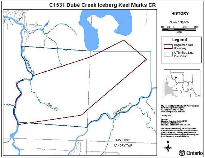
Map 6 – History
11.0 Appendices
Appendix A: SCI Test of Compatibility
The Conservation Reserve policy provides broad direction with regard to the permitted uses. The policy provides only an indication of the variety of uses that will be considered acceptable in conservation reserves. Any new uses, and commercial activities associated with them, will be considered on a case by case basis, and, subject to the following test of compatibility. To ensure a standard screening process is followed, reviews of all current and new activities will be subject to the screening criteria as specified by the Environmental Assessment Act (R.S.O. 1900, Chapter E.18).
The following outlines the two steps involved in performing a Test of Compatibility. An assessment of current activities would only follow step two, which focuses on the impacts. An assessment of any new activity would consider the impact of the activity and its conformity to the SCI/RMP.
-
Conformity to SCI/RMP: SCI describe values for which an area has been set aside and the range of appropriate uses that will be permitted in the area. SCI may also speak to the acceptability of other 'new' uses currently not occurring in the area.
The first 'test' is: "do proposed new land uses and/or commercial activities conform to the direction of the SCI/RMP for the conservation reserve? Would the new use(s) depart from the spirit of appropriate indicator land uses in the SCI/RMP?"
- Impact Assessment: If the proposed use(s) pass test 1 it is important to determine their impact on the area before they are approved. This should include the following:
- Impact on natural heritage values: "will the new use(s) impact any natural values in the area? If so how and to what degree? Is it tolerable?"
- Impact on cultural values: "will the new use(s) impact an historical or archaeological values in the area?"
- Impact on research activities: "will the new use(s) affect research activities in the area?"
- Impact on current uses: "will the new use(s) have any negative impact on the array of current uses?"
- Impact on area administration: "will the new use(s) increase administrative costs and/or complexity?" (For example, the cost of area monitoring, security and enforcement).
- Impact on accommodating the use outside the conservation reserve: "Could the use(s) be accommodated as well or better outside the conservation reserve?"
- Impact on socio-economics of the area: "will the new use(s) affect the community(ies) surrounding the area in a positive or negative way?" (For example, will the new use make an area less remote thereby affecting a local tourism industry that is dependent on the area’s remoteness for its appeal?"
- Impact on area accessibility: "does the new use(s) give someone exclusive rights to the area or a portion of the area to the exclusion of other existing uses?
Appendix B: Crown Land Use Atlas – policy report
Identification:
ID: C1531
Area Name: Dubé Creek Iceberg Keel Marks
Area (ha): 1,138
Designation: Conservation Reserve (Ontario’s Living Legacy)
District(s): Hearst
Description:
A complex of linear, furrow like marks appear to have been cut into glaciolacustrine sediments. These marks were formed by icebergs floating in glacial Lake Ojibway. This site is required to complete the Cochrane Events Environmental Theme.
The dominant landform vegetation type found here is: weakly broken ground moraine with dense coniferous forest. Other vegetation types represented include: mixed deciduous forest, mixed coniferous forest, sparse forests, and wetlands.
Land use intent:
Boundary to be refined to allow for an access corridor along Mattawishwia River. The intent is to regulate this area as a conservation reserve. Management of this area is also governed by the general policies contained in the Land Use Strategy (1999).
Management direction:
Those uses and management activities not listed in the following table are governed by existing conservation reserve policy. Over time the management direction will be elaborated in a Statement of Conservation Interest or Resource Management Plan. Any new uses, and commercial activities associated with conservation reserves, will be considered on a case by case basis, and they must pass a test of compatibility to be acceptable. Compatibility is normally determined through a planning process.
Commercial activities
| Activity | Permitted | Guidelines |
|---|---|---|
| Aggregate Extraction | No | |
| Bait Fishing Existing: | Yes | Existing use permitted to continue, unless there are significant demonstrated conflicts. |
| Bait Fishing New: | Maybe | New operations can be considered, subject to the "test of compatibility". |
| Commercial Fishing Existing: | Yes | Existing use permitted to continue, unless there are significant demonstrated conflicts. |
| Commercial Fishing New: | Maybe | New operations can be considered, subject to the "test of compatibility". |
| Commercial Fur Harvesting Existing: | Yes | Existing use permitted to continue, unless there are significant demonstrated conflicts. Existing trap cabins can continue; new cabins are not permitted. |
| Commercial Fur Harvesting New: | Maybe | New operations can be considered, subject to the "test of compatibility". |
| Commercial Hydro Development | No | |
| Commercial Timber Harvest | No | |
| Commercial Tourism Existing: | Yes | Existing authorized facilities can continue, unless there are significant demonstrated conflicts. |
| Commercial Tourism New: | Maybe | New tourism facilities can be considered during the planning for an individual reserve. |
| Bear Hunting by Non-residents (guided) Existing: | Yes | Existing authorized operations permitted to continue. |
| Bear Hunting by Non-residents (guided) New: | No | New operations not permitted. |
| Outfitting Services Existing: | Yes | Existing authorized operations permitted to continue. |
| Outfitting Services New: | Maybe | New operations can be considered during the planning for an individual reserve. |
| Outpost Camps Existing: | Yes | Existing authorized operations permitted to continue. |
| Outpost Camps New: | Maybe | New operations can be considered during the planning for an individual reserve. |
| Resorts/lodges Existing: | Yes | Existing authorized facilities permitted to continue. |
| Resorts/lodges New: | Maybe | New facilities can be considered during the planning for an individual reserve. |
| Boat Caches (Managed) | ||
| Energy Transmission and Communications Corridors Existing: | Yes | |
| Energy Transmission and Communications Corridors New: | No | These facilities should avoid conservation reserve lands wherever possible. |
| Food Harvesting (Commercial) Existing: | Maybe | |
| Food Harvesting (Commercial) New: | Maybe | |
| Mineral Exploration and Development | No | |
| Peat Extraction | No | |
| Wild Rice Harvesting Existing: | Yes | |
| Wild Rice Harvesting New: | Maybe |
Land and resource management activities
| Activity | Permitted | Guidelines |
|---|---|---|
| Crown Land Disposition Private Use: | Maybe | Sale of lands is not permitted, except for minor dispositions in support of existing uses (e.g. reconstruction of a septic system). Renewals of existing leases and land use permits are permitted. Requests for transfer of tenure will be considered in the context of the Statement of Conservation Interest or Resource Management Plan. |
| Crown Land Disposition Commercial Use: | Maybe | New leases or land use permits permitted for approved activities. Tourism facilities can apply to upgrade tenure from LUP to lease. |
| Fire Suppression | Yes | Fire suppression policies are similar to adjacent Crown lands, unless alternative fire policies have been developed through a planning process. |
| Fish Habitat Management | Maybe | |
| Fish Stocking | Maybe | Conservation Reserves policy indicates that "featured species management" may be permitted. |
| Insect/disease Suppression | Maybe | |
| Inventory/Monitoring | Maybe | |
| Prescribed Burning | Maybe | |
| Roads (Resource Access) Existing: | Yes | Existing roads can continue to be used. Continued use will include maintenance and may include future upgrading. |
| Roads (Resource Access) New: | Maybe | New roads for resource extraction will not be permitted, with the exception of necessary access to existing forest reserves for mineral exploration and development. |
| Vegetation Management | Maybe | Conservation Reserves policy indicates that Featured Species Management and Natural Systems Management may be permitted. Vegetation management can be considered in a planning process. |
| Wildlife Population Management | Maybe |
Science, education and heritage appreciation
| Activity | Permitted | Guidelines |
|---|---|---|
| Collecting | No | |
| Historical Appreciation | Yes | |
| Nature Appreciation | Yes | |
| Photography and Painting | Yes | |
| Research | Yes | |
| Wildlife Viewing | Yes |
Recreation activities and facilities
| Activity | Permitted | Guidelines |
|---|---|---|
| All Terrain Vehicle Use On Trails: | Yes | Existing use permitted to continue where it does not adversely affect the values being protected. |
| All Terrain Vehicle Use Off Trails: | No | ATV use off trails is not permitted except for direct retrieval of game. |
| Campgrounds | Maybe | |
| Food Gathering | Yes | |
| Horseback Riding (trail) | Yes | Existing use on trails permitted. |
| Hunting | Yes | |
| Mountain Bike Use | Yes | Existing use on trails permitted. |
| Motor Boat Use Commercial: | Yes | |
| Motor Boat Use Private: | Yes | |
| Non-motorized Recreation Travel | Yes | |
| Private Recreation Camps (Hunt Camps) Existing: | Yes | Existing camps permitted to continue, and may be eligible for enhanced tenure, but not purchase of land. |
| Private Recreation Camps (Hunt Camps) New: | No | |
| Rock Climbing | Maybe | |
| Snowmobiling On Trails: | Yes | Existing use permitted to continue where it does not adversely affect the values being protected. |
| Snowmobiling Off Trails: | Maybe | Snowmobile use off trails is not permitted, except that snowmobiles may be used for direct retrieval of game. |
| Sport Fishing | Yes | |
| Trail Development Existing: | Maybe | Development of trails for a variety of activities (e.g. hiking, cross-country skiing, cycling, horseback riding, snowmobiling) can be considered as part of planning for an individual reserve. |
| Trail Development New: |
Note: The policies outlined in this table do not supersede any Aboriginal or treaty rights that may exist, or other legal obligations.
Management of this conservation reserve is carried out within the context of Conservation Reserve policy as amended by the policies for new conservation reserves outlined in the Ontario’s Living Legacy Land Use Strategy.
Source of direction:
Ontario’s Living Legacy Land Use Strategy (1999); Conservation Reserves Policy (1997); Hearst District Land Use Guidelines (1983)