Eastern Cardwell Forest Conservation Reserve Management Statement
This document provides policy direction for the protection, development and management of the Eastern Cardwell Forest Conservation Reserve and its resources.
Ministry of Natural Resources
Parry Sound District
Prepared with the assistance of:
Meteek & Company
Huntsville, Ontario
March 2005
Approval statement
We are pleased to approve this Statement of Conservation Interest for Eastern Cardwell Forest Conservation Reserve (C102).
Eastern Cardwell Forest Conservation Reserve is 627 hectares in area, and consists of six separate parcels of Crown land. It is located about 23 kilometres northwest of the Town of Huntsville, in eastern Cardwell Ward in the Township of Muskoka Lakes in the District Municipality of Muskoka. The site lies approximately ½ kilometre north of Muskoka Road 3 (Aspdin Road) and 2½ kilometres north of Skeleton Lake.
Eastern Cardwell Forest Conservation Reserve is surrounded mainly by privately owned lands, which are not part of this conservation reserve.
This conservation reserve, located in Hills' ecological Site District 5E-8, drains mostly north and west into the Rosseau River watershed, with some drainage to the Black Creek watershed, and some southward to Skeleton Lake.
The name of this protected area is being changed from Long Lake – Lancelot Creek Conservation Reserve (as referred to in the Ontario’s Living Legacy Land Use Strategy) to Eastern Cardwell Forest Conservation Reserve. It was recognized that the former name was not representative of the watershed drainage of the area, and that the new name better reflects the location and the key values of this site. No public concerns were expressed when the proposal to change the site name was made.
This exceptionally diverse and outstanding forested area includes several combinations of vegetation and landforms. It is used for a variety of traditional recreational uses, including snowmobiling and hunting.
Eastern Cardwell Forest Conservation Reserve is one of 378 new protected areas approved through Ontario’s Living Legacy Land Use Strategy, aimed, in part, at completing Ontario’s system of parks and protected areas.
During the "Lands for Life" planning process, the public was widely consulted and provided valuable input into what became Ontario’s Living Legacy Land Use Strategy. Comments received during that time, and during consultation related to the formal Public Lands Act regulation of the boundaries of this conservation reserve, were generally supportive of the protection of this area. Stakeholders who provided comment during the earlier consultation for this site were subsequently consulted regarding the draft Statement of Conservation Interest and any comments were considered in the finalization of this document.
This Statement of Conservation Interest provides guidance for the management of the conservation reserve and provides the basis for the ongoing monitoring of activities. More detailed direction is not anticipated at this time. Should more complex resource management or conservation issues arise or significant facility development be considered, then a detailed Resource Management Plan will be prepared with full public consultation.
Eastern Cardwell Forest Conservation Reserve is managed under the direction of the District Manager and the Bracebridge Area Supervisor of the Ministry of Natural Resources, Parry Sound District.
Approved by:
R. Griffiths
District Manager
Parry Sound District
Approved by:
Ron Running
Regional Director
Southern Region
Figure 1: Location of Eastern Cardwell Forest Conservation Reserve
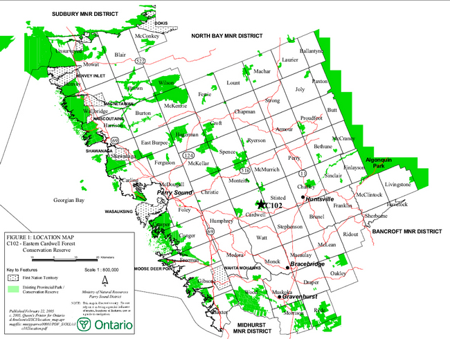
Enlarge Figure 1: Location of Eastern Cardwell Forest Conservation Reserve
Figure 2: Site Map – Eastern Cardwell Forest Conservation Reserve
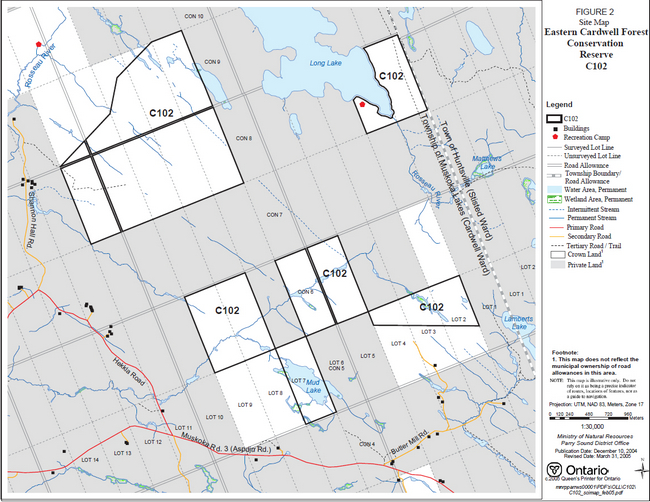
Enlarge Figure 2: Site Map – Eastern Cardwell Forest Conservation Reserve
1.0 Introduction
Ontario’s Living Legacy, the result of an extensive planning process that began in early 1997, culminated in the approval in July 1999 of a Land Use Strategy that identifies the intended strategic direction for Crown land in central and northern Ontario, including the completion of Ontario’s system of parks and protected areas. This process, which included public consultation, resulted in the recommendation for regulation of 378 new protected areas, including Eastern Cardwell Forest Conservation Reserve (C102).
Eastern Cardwell Forest Conservation Reserve consists of 627 hectares of Crown land, comprising six separate parcels of Crown land. It is located about 23 kilometres northwest of the centre of the Town of Huntsville, and about 12 kilometres east of the village of Rosseau. It lies in eastern Cardwell Ward of the Township of Muskoka Lakes in the District Municipality of Muskoka.
This conservation reserve, located in Hills' ecological Site District 5E-8, provides headwater drainage for the Rosseau River starting around Long Lake, with some drainage to the Black Creek watershed, and some to Skeleton Lake.
The headwaters of Lancelot Creek begin about 3.5 kilometres east of the eastern-most parcel of this conservation reserve. For this reason MNR concluded that the original name for this site (Long Lake – Lancelot Creek Conservation Reserve), as identified in the Land Use Strategy, was not appropriate. After a public consultation process in early 2005, with no public concerns identified, MNR is officially changing the name of this site to Eastern Cardwell Forest Conservation Reserve.
The underlying bedrock creates a height of land with northwest-southeast trending topography of low hills, ridges and troughs, resulting in a convoluted drainage pattern. The largest block of this site, in the northwest, drains northwest to the Rosseau River. The northeast block drains directly into adjacent Long Lake, and the Rosseau River. The extreme eastern edge of this block (Lot 1, Concession 8, Cardwell) may drain into the Black Creek headwaters. The four southerly blocks all drain westerly through a creek that joins the Rosseau River at Hekkla. The extreme eastern edge of the southeast block (Lot 2, Con 5, Cardwell) drains southerly past Lamberts Lake, into Skeleton Lake. To the east of this conservation reserve, a large complex of wetlands forms the headwaters of the Black Creek drainage system, and adjoins the headwaters of the Lancelot Creek drainage system.
This exceptionally diverse and outstanding forested area includes forty-one documented combinations of vegetation and landforms. It is used for a variety of traditional recreational uses, including snowmobiling and hunting, although access is limited to the site, since it is mostly surrounded by private lands.
Conservation reserves are established under the authority of the Public Lands Act, Ontario Regulation 805/94. Eastern Cardwell Forest Conservation Reserve was established by Ontario Regulation 148/02 on May 8, 2002, under the name "Long Lake – Lancelot Creek Conservation Reserve". That regulation will be amended in 2005 to reflect the new name.
A Statement of Conservation Interest is prepared under the direction of Procedural Guideline A – Resource Management Planning (PL. Procedure 3.03.05). The purpose of this Statement of Conservation Interest is to identify and describe the values of Eastern Cardwell Forest Conservation Reserve. The Statement of Conservation Interest also outlines the activities that currently occur within the conservation reserve and provides guidelines for the management of current and future activities in the context of protecting the natural, recreational and cultural values.
1.1 Background information:
| Name | Eastern Cardwell Forest Conservation Reserve (C102) |
|---|---|
| Site Region/District | Georgian Bay Site Region, Site District 5/E-8 |
| OMNR Administrative Region/District/Area | Southern Region/ Parry Sound District/ Bracebridge Area |
| Total Area (ha.) | 627 hectares |
| Regulation Date | May 8, 2002 (O. Reg. 148/02) |
| First Nations | Robinson-Huron Treaty and Williams Treaty |
| OBM map sheets | 10 17 6150 50150, 6150 50200, 6200 50150 |
| Topographic Map | Orrville 31 E/5 Huntsville 31/E6 |
| UTM co-ordinates | 17T 61520 501960 (Centroid of largest parcel) |
1.2 Representation
Earth science representation:
Bedrock - Tectonized metaplutonic components of Seguin Domain, Parry Sound Terrane close to boundary with Rosseau Domain, Algonquin Terrane.
Surficial - The variety of bedrock-drift complex deposits are typical components of Late Wisconsinian Stage of the Quaternary Era in southern Ontario.
Life science representation:
Eastern Cardwell Forest Conservation Reserve, in Hills' ecological Site District 5E-8, provides representation of 41 documented combinations of vegetation and landforms, including: sugar maple forests and hemlock forests on a variety of moisture regimes, substrates and slopes; a large open bog; and a variety of beaver- influenced ponds marshes and streams.
Cultural resources representation:
Neither detailed cultural research nor inventory has been carried out for this conservation reserve.
Recent regional evaluation (OMNR, 2003) shows that this conservation reserve contains some areas that have a high potential for cultural heritage sites.
Recreational opportunities:
A recreational inventory report was prepared for this site based on existing knowledge and data sources of MNR staff, as well as site visits (Gavel, 2003). Currently, it is used for big game hunting, with some access by snowmobiles and all-terrain vehicles.
1.3 Survey work
| Survey Level | Earth Science | Life Science | Cultural | Recreational | Other |
|---|---|---|---|---|---|
| Reconnaissance | Duba & Frey, 2001 | Jones, 2003 | OMNR, 2003 | Gavel, 2003 | None |
| Detailed | None | None | None | None | None |
| Requirement | None | Monitor the status/ presence of significant species and associations. | Research to be encouraged | Monitor use impacts | None |
2.0 Values to be protected
The conservation reserve is located entirely within Hills' (1959) ecological Site District 5E-8. Values include earth science, life science and recreational/aesthetic values, with an emphasis on the life sciences.
2.1 Earth science:
(Earth science information, unless otherwise noted, is taken from Duba & Frey, 2001)
Bedrock:
Eastern Cardwell Forest Conservation Reserve is an area of low relief land parcels straddling a height of land that drains mostly to the Rosseau River system. The dominant rock type is tectonized intermediate gneiss of probable metaplutonic protolith (metagranodiorite to metatonalite), with subordinate metagabbro inclusions of the Seguin Domain, Parry Sound Terrane, in the Central Gneiss Belt of the Proterozoic Grenville Province (Lumbers & Vertolli, 2000 a & b).
The Grenville Province is the product of thrusting and imbrication of the crust to the northwest as it collided with a continental landmass to the southeast. The Grenville Orogeny, circa 1140 to 1070 million years ago, culminated more than 500 million years of crustal evolution. The eroded roots of the products of these events are displayed in the complexly metamorphosed and deformed rocks of the region (Easton, 1992b).
The Parry Sound Terrane is one of the four lithotectonic terranes of the Central Gneiss Belt. The Seguin Domain is one of three structural domains of the Parry Sound Terrane. This geological environment is part of the modern organization of the complex products of the mid-Proterozoic orogenic events (Easton 1992a & b). As such, their representation in Eastern Cardwell Forest Conservation Reserve contributes to the conservation of the Grenville Province continental accretion theme (Davidson, 1981).
Within the Ontario Provincial Park system, the bedrock geological features observed in Eastern Cardwell Forest Conservation Reserve have regional significance in their representation of the tectonized metaplutonic components of the complex products of the Seguin Domain, Parry Sound Terrane, close to the boundary with the Rosseau Domain, Algonquin Terrane.
Surficial:
A large area, including Eastern Cardwell Forest Conservation Reserve, was submerged in the expansion of glacial Lake Algonquin during the deglaciation from about 11,500 to 10,200 years before present (Eschman & Karrow, 1985). Bedrock drift complexes underlie more than 80% of the conservation reserve, consisting predominantly of discontinuous, thin, loose, stoney and sandy till, with minor sand and sand/gravel of glaciolacustrine and glaciofluvial ice-contact origin, and very rare silt and clay of glaciolacustrine origin associated with ice-contact deposits. Recent deposits of swamp and organic matter underlie narrow, linear, commonly northwest trending depression. Surficial geology of the conservation reserve is locally significant.
2.2 Life science:
(Life science information, unless otherwise noted, is taken from Jones, 2003)
Eastern Cardwell Forest Conservation Reserve, located within Hills' (1959) ecological Site District 5E-8, was selected as a candidate area for protection during the natural heritage gap analysis process associated with "Lands for Life", a precursor to Ontario’s Living Legacy. The purpose of the gap analysis was to identify different vegetation and landform combinations that were not presently included in protected areas. Geographic Information Systems (GIS) technology was used and applied to the following criteria: 1) representation of landform-vegetation patterns; 2) diversity; 3) condition; 4) ecological considerations; and 5) special features (Crins and Kor, 1998).
Representation:
Eastern Cardwell Forest Conservation Reserve was selected for its representation of 41 different combinations of vegetation and landforms. The area contains common habitats such as hemlock and sugar maple forests as well as numerous wetlands, thickets, and beaver ponds in long, narrow drainages formed by troughs in the underlying bedrock. The six separate parcels of the conservation reserve straddle the headlands of the Rosseau River and Black Creek, with some drainage also to Skeleton Lake.
The great variation in topography creates a large diversity of vegetation types, with subtle changes in moisture, shade, substrate and slope. The most common vegetation types in the conservation reserve are sugar maple (Acer saccharum) forests, with the best example being species-rich with yellow birch (Betula allegheniensis) and hemlock (Tsuga canadensis) as associates. In the northern block of the reserve, sugar maple forests are found on the slopes above the long troughs, with larger occurrences on the somewhat more level ground at the southeast and southwest corners of the block. In the southern block sugar maple forests are mostly found on south-facing drainage valleys, as well as an excellent example on the slope above the south side of the creek on Lot 8, Concession 6.
Also very common are hemlock forests, varying from dry hemlock forest with almost no ground flora or with a shrub layer of striped maple (Acer pensylvanicum), to mesic forests with a dense understory of young balsam fir (Abies balsamea), to moist forests with yellow birch as an associate and cinnamon fern (Osmunda cinnamomea) covering the ground.
Other forest vegetation in the conservation reserve includes an open, mixed forest of red maple and balsam fir, white spruce (Picea glauca) and large-toothed aspen (Populus grandidentata), with lots of young red maples in the understory. Another version of this is a forest dominated by red maple with large-toothed aspen and with a thick tall shrub layer of balsam fir. Also in this category is a mixed forest dominated by middle-aged poplars in the eastern arm of the southern block. One example of forest dominated by white pine (Pinus strobus) was noted, and this type is probably more wide-spread in the site than noted during field inspection. Finally, an example of yellow birch forest was documented with red maple and black cherry (Prunus serotina) as associates. This forest has a sub-canopy of sugar maples about 8 metres tall.
At the south end of Long Lake there is mixed forest of trembling aspen (Populus tremuloides), white cedar (Thuja occidentalis), red maple (Acer rubrum) and white pine on the sloping ground above the lake. This is backed by sugar maple-hemlock-yellow birch forest on the higher ground on Lot 1.
The conservation reserve has an incredible array of wetlands, based on organic peat soils that have formed in the low-lying troughs in the bedrock. Beaver activity has been widespread in these troughs creating many series of pools and meadows. In the northern block of the conservation reserve, treed bogs, treed fens, tamarack (Larix laricina) swamps and other Sphagnum-based vegetation are prevalent, whereas in the southern block meadow marshes mostly of Canada bluejoint (Calamagrostis canadensis) or wool-grass (Scirpus cyperinus) are common, sometimes mixed with beaked sedge (Carex utrichulata). Both north and south blocks have many shallow, mucky beaver ponds with a shallow aquatic community dominated by water lily (Nymphaea odorata) and yellow pond lily (Nuphar variegatum). These ponds usually have a shoreline marsh around them, which is dominated by wool-grass and bluejoint, often with the addition of three-way sedge (Dulichium arundinaceum). All areas of the conservation reserve have various thicket swamps dominated by alder (Alnus rugosa) or winterberry (Ilex verticellata), or sometimes instead of this, the many narrow, wet areas are simply open and filled with ferns: cinnamon fern, sensitive fern (Onoclea sensibilis) royal fern (Osmunda regalis), as well as fringed sedge (Carex crinita).
At the south end of Long Lake there is a very large open bog (~45 hectares, of which 5 hectares are in the reserve), which appears as a huge field of few-seeded sedge (Carex oligosperma) with hummocks of leatherleaf (Chamaedaphne calyculata) present, but very few other species, as is typical of true bogs. The edge of this community, along the lake, has a few more species including bog aster (Aster nemoralis) and meadow sweet (Spiraea tomentosa and S. alba).
Sheer rock walls covered with rock tripe lichen (Lasallia sp.) are also of interest.
Because the terrain in the conservation reserve is so finely divided by topographic features (troughs, waterways, drainage valleys, cliffs, and rocky knolls) the vegetation communities are laid out on the ground a very mixed-up, interspersed way with many fairly small polygons, rather than larger areas.
Condition:
Many parts of the conservation reserve have large trees present indicating that fire has not passed through these areas for more than 100-200 years. The mesic nature of the soil and the steep, wetland-containing ravines probably make it difficult for fire to carry in this terrain. Direct burn evidence (charcoal, burnt stumps) was not observed anywhere in the conservation reserve. OMNR digital fire history mapping shows a fire burned in the 1920's about 5 km from the south boundary of the southern block of the conservation reserve, but it does not appear to have approached the site.
The wetlands of the conversation reserve are undisturbed, although there may be on going beaver activity causing changes in water flow. No exotic species were observed. Forested areas were also free of weeds. It is speculated that the lack of trails and road access to the site has prevented the entry of exotic species.
No evidence of current resource extraction activities was noted within the site. However, adjacent private lands show evidence of logging with large openings, skid trails, and new, wide roads present. This has the potential of fragmenting the habitat between the separated blocks of the conservation reserve.
There is no direct public road access to any part of the conservation reserve, although there is access by trails and roads through private land in several locations.
Diversity:
Using a slightly different classification than the gap analysis, 22 landform-vegetation types were documented during the two day site inspection in August 2003. These vegetation types were defined based on standard ecological land classifications of Ontario (Chambers et al. 1997) which have been applied to create a complete classification for the greater Georgian Bay area by Jalava et al. (2002). The conservation reserve is notable for its great diversity of both terrestrial and wetland community types. These vegetation types provide habitat for at least 142 vascular plant species.
Most common animals probably use the conservation reserve. Eastern chipmunks and red squirrels were frequently seen during site inspection, and moose sign was abundant. The site has had extensive beaver activity, but only a little of it appeared recent. No bear sign was seen. No reptiles or amphibians were seen but additional survey work would likely identify the common species, especially in the southern block of the conservation reserve where there are ponds.
Breeding birds were not specifically surveyed during the recent field inspection; however, 17 species were seen incidentally. It is certain that a much greater number of species are present. Four mammal species were noted (sightings, tracks or droppings). Large numbers of timber wolf scats and tracks were seen on another occasion. Several kinds of Odonata were observed in different wetlands, including red dragonflies of the genus Sympetrum, blue damselflies of the genus Enallagma, and several other large dragonflies, probably in the Skimmer group.
Ecological considerations:
Eastern Cardwell Forest Conservation Reserve consists of separate, disconnected parcels of land, which have different sets of values. The fact that the six separate blocks of this site are mostly surrounded by patent lands means that at some later date protection of the area as a landscape may be difficult.
The boundaries of this conservation reserve generally follow surveyed lot lines. These boundaries are not ecologically based, cutting across drainage ravines and taking in only small corners of the lakes in the northern and southern blocks, rather than encompassing entire habitats or wetlands. The Long Lake block takes in only about 1/4 of the large bog, meaning that activities outside the conservation reserve could, at some later date, affect the long-term viability of this wetland.
Special features:
No provincially rare species were found.
The large, open bog present at the south end of Long Lake may be regionally significant, as true bogs are unusual in this part of Ontario (Jan McDonnell, OMNR, pers. com.). Its large size, as well, may be unusual for the area.
2.3 Cultural values:
While no specific cultural studies or inventories have been undertaken within the conservation reserve, and no major cultural resource values have been evaluated or identified to date, recent regional evaluation (OMNR, 2003) provides generalized broad-based mapping which shows that this conservation reserve contains areas that may have a high potential for cultural heritage sites.
2.4 Recreational/aesthetic values:
Eastern Cardwell Forest Conservation Reserve is a long-standing traditional hunting area. One authorized Crown land recreation camp is located within the conservation reserve on the parcel adjacent to Long Lake. Three other hunt camps are located on private and Crown land near the conservation reserve. Most hunting activity focuses on white-tailed deer, moose and black bear. There may also be some limited waterfowl and small game hunting within the site.
Mud Lake is lightly fished for smallmouth bass, and Long Lake is fished for lake trout in spring and summer, mostly by local anglers, and in the winter with access from an unauthorized snowmobile trail that passes near or through the conservation reserve, east of Long Lake.
Lack of public access restricts the potential of this site for recreational use, and there is little evidence of hiking, canoeing, snowshoeing, cross-country skiing or nature study pursuits within the conservation reserve.
The distance of this conservation reserve from urban areas has resulted in a relatively pristine night sky, which enhances the sense of remoteness and wilderness of this site. Pristine night skies are considered a significant value, given the increasingly limited areas of southern and central Ontario that are not heavily affected by light pollution.
3.0 Management guidelines
MNR's Class Environmental Assessment for Provincial Parks and Conservation Reserves came into effect on January 10, 2005. All new MNR projects in conservation reserves, and any new approvals or permits issued, must meet the legal requirements of this Class Environmental Assessment, and any relevant amendments.
3.1 Land tenure:
Background:
Eastern Cardwell Forest Conservation Reserve consists of 627 hectares of Crown land, located about 23 kilometres northwest of the centre of the Town of Huntsville, and about 12 kilometres east of the village of Rosseau. It lies in eastern Cardwell Ward in the Township of Muskoka Lakes in the District Municipality of Muskoka.
It is surrounded mainly by privately owned lands, which are not part of this conservation reserve. The municipal road allowances that abut against or cross the parcels of this site are not a part of the conservation reserve, nor is the shore road allowance along Long Lake.
The conservation reserve is surrounded by Bear Management Area PS-49-09, but the area of the conservation reserve is excluded. It lies mostly within two Bait Fish Blocks (PS166 & PS167). It is not within a registered trapline area; however, resident trappers may be licensed to trap within and around the site.
There is one authorized recreation camp within the boundaries of the conservation reserve.
Guideline:
The sale of Crown lands within the conservation reserve is generally not permitted. Exceptions will only be considered under unusual circumstances, such as where a pre-existing, adjacent, privately owned parcel has inadequate area for the installation of a septic system; this circumstance is unlikely to apply for this conservation reserve.
There are no plans by the MNR to acquire private lands to add to the conservation reserve. However, MNR may consider donations of suitable private lands that would have the effect of consolidating natural features.
The Bait Fish Blocks, currently assigned, are permitted to continue. While not within a registered trapline area, local trapping may be authorized within this site through resident trapping licences. Commercial bear hunting service associated with the Bear Management Area is not allowed within the boundaries of the conservation reserve. This site, or portions of it, cannot be incorporated into a Bear Management Area.
The existing recreation camp within the conservation reserve is permitted to continue. It may be eligible for enhanced tenure, but it is not eligible for purchase of land (See Appendix 4). Where authorized in writing, the Ministry of Natural Resources would consider permitting transfer of ownership, or alterations to authorized recreational camps, so long as there are no negative impacts on the values of the conservation reserve.
New recreation camps are not permitted.
While commercial timber harvesting is not allowed within conservation reserves, there are limited situations in which adjacent land owners, permittees or lessees can harvest firewood for use on their adjacent property. Specifically, property owners, permittees or lessees with adjacent small lots who have no road access to their properties can apply for permits to cut limited amounts of firewood in the conservation reserves for their own use. This situation would apply only to the water access recreation camp within the conservation reserve boundaries.
3.2 Development:
Background:
There are no Crown owned buildings or other facilities within the conservation reserve.
The northwest block of this conservation reserve has had access by all-terrain vehicle and snowmobile along the unopened municipal road allowance from Shannon Hall, between Lot 11, Concession 8, and Lot 11, Concession 9, although this appears to be an unmaintained access used primarily during the fall hunting season.
Access to the Mud Lake area is through a gated private road originating from a municipal gravel pit on Lot 6, Concession 4, Cardwell Township. The southeast blocks (Lots 4 & 5, Concession 5 and Lot 5 Concession 6, Cardwell Township) are also accessible by a gated private access road originating from Lot 4, Concession 4.
Long Lake, and thus the northeastern portion of the conservation reserve, is accessible by a private road, originating from a municipal road in Stisted Township. One can also walk across Crown land from the municipal road to gain access to Long Lake.
An unauthorized snowmobile trail crosses Lot 1 Concession 8, Cardwell Township. This was believed to have been located on the road allowance between Stisted and Cardwell Townships, but the precise trail location is not known at the time of preparation of this Statement of Conservation Interest. It is assumed to lie within or near the boundaries of the conservation reserve. In the winter, this trail gives additional access to the Long Lake area.
Guideline:
New private access or resource access roads, and additions to or upgrading of existing roads are not permitted. There is no intention to develop or improve roads or trails outside of the conservation reserve to improve access to this site.
The use of the unauthorized trail that passes through Lot 1, Concession 8, Cardwell Township will be monitored. Depending on the results of monitoring, some or all of this unauthorized trail may need to be redirected from sensitive areas or eliminated completely. There is no intent to mark or upgrade this trail. Similarly, other unauthorized trails will be monitored.
New recreational trails may be considered on a case by case basis, as is discussed in more detail in Section 3.3 "Recreational Activities". New recreational trails for motorized vehicles are discouraged and will only be considered under exceptional circumstances if the criteria identified in Section 3.3 have been demonstrated.
Unauthorized works within the conservation reserve will be handled in accordance with the Public Lands Act, and any required removal of these works will be at the expense of those responsible.
No mineral exploration is permitted within this conservation reserve. This policy direction is based on a commitment made by the Ministry of Natural Resources and the Ministry of Northern Development and Mines in March, 2002. This direction replaces that identified in the 1999 Ontario’s Living Legacy Land Use Strategy (OMNR, 1999), which stated that controlled mineral exploration would be permitted in new conservation reserves which were identified as having provincially significant mineral potential.
Any new development must meet MNR's commitments to protect cultural heritage values (see Section 3.7).
While there is no intent at present to provide or permit any new development in this conservation reserve that would require lighting, should this be considered at some point in the future the MNR will not allow unnecessary, undirected light pollution. This commitment recognizes the wilderness and biological values provided by a pristine night sky.
3.3 Recreational activities:
Background:
The area accommodates big game hunting, and possibly some waterfowl hunting.
There are no major waterbodies contained within the boundaries of the conservation reserve, although the site does contain most of Mud Lake (a 17 hectare warm water lake in the southern block) and several beaver- dominated waterbodies. Long Lake, a 191 hectare coldwater lake, is adjacent to the Long Lake block of the conservation reserve but not within the site. Mud Lake is known to be angled for smallmouth bass (Micropterus dolomieu), and Long Lake is managed for lake trout (Salvelinus namaycush) and whitefish (Corygonus clupeaformis), and experiences some winter fishing with access from the unauthorized snowmobile trail that passes through or near the east boundary of the site at Lot 1 Concession 8, Cardwell Township.
Hunting and fishing activity is considered light, and there is little evidence of the use of the conservation reserve by other activities, (e.g. hiking, snowshoeing, cross-country skiing, nature studies) probably because of lack of public access.
Guideline:
Angling and hunting are permitted to continue within the conservation reserve.
Recreational uses such as hiking, wildlife viewing, snowshoeing, and cross-country skiing, while currently very limited in extent and therefore not managed, are allowed to occur in the conservation reserve.
The location and use of pre-existing recreation trails (trails that existed at the time of regulation of this conservation reserve), and any increase in use of snowmobiles or all-terrain vehicles, will be monitored to ensure that conservation reserve values are not being adversely impacted. Depending on the results of monitoring, pre-existing trails may need to be redirected from sensitive areas or eliminated completely. There is no intent to mark or upgrade these trails.
New recreational trails may be considered on a case by case basis provided that they meet Procedural Guideline B – Land Uses – Test of Compatibility (see Appendix 1) and the MNR's Environmental Assessment Act requirements. Public consultation will generally be required during the consideration of changes to existing trails, and will always be required for new trails. Any new trails must meet MNR's commitments to protect cultural heritage values (see Section 3.7).
New recreational trails, or up-grading of existing trails, for motorized vehicles are discouraged and will only be considered under exceptional circumstances if the following have been demonstrated:
- there is a community need for the trail, as well as community support;
- there are no alternative suitable locations outside the conservation reserve;
- the trail location would be acceptable and suitable for four-season use;
- the trail would meet the requirements applicable to all trails, as identified in the preceding paragraph.
Off-trail use of snowmobiles and all-terrain vehicles is not permitted, except for the direct retrieval of game.
New recreational activities will be considered on a case by case basis provided they are consistent with maintaining the values of the conservation reserve and comply with Procedural Guideline B – Land Uses – Test of Compatibility (Appendix 1). Emphasis will be placed on activities that have a low impact on the environment of the conservation reserve.
Monitoring of existing and permitted activities will be undertaken as required to ensure that the conservation reserve values are not being adversely impacted.
3.4 Commercial activities:
Background:
There has been no recent commercial forest harvesting or mining activity within the conservation reserve.
Bait fish harvesting is authorized through two Bait Fish Block licences that cover the site. While not within a registered trapline area, fur harvest can be authorized through resident trapping licences. The guiding of non-resident bear hunters is not authorized within the conservation reserve. These activities were discussed in Section 3.1 Tenure – Background.
Guideline:
Fur harvesting and bait fish harvesting operations are allowed to continue within the conservation reserve. New trapline cabins are not permitted within conservation reserves.
Conservation reserve regulations do not permit mineral exploration, mining, commercial forest harvesting, hydroelectric power development, the extraction of aggregate and peat or other industrial uses (Public Lands Act, Ontario Regulation 805/94). Other new commercial activities must meet the requirements of Procedural Guideline B – Land Uses – Test of Compatibility (Appendix 1).
3.5 Aboriginal interests:
Background:
This site is known to be of interest to First Nation communities. There are 2 treaties associated with the area: the Robinson – Huron Treaty of 1850 and the Williams Treaty, (although a Supreme Court decision in 1994 (Howard) validated that the Williams Treaty surrendered hunting, fishing and trapping rights of those First Nations affiliated with that treaty).
Guideline:
The regulation and management of this conservation reserve will not impede the exercise of existing aboriginal or treaty rights. These rights include hunting, fishing, fur harvesting, gathering of plants for a variety of purposes, and the use of ceremonial sites. It is recognized that the manner in which these rights are carried out is not limited to the manner in which they were carried out in the past, but has evolved over time with changes in technology.
The designation of this area as a conservation reserve or the preparation of this Statement of Conservation Interest will not affect any future First Nation land claim settlement. The conservation reserve designation does not preclude consideration of these lands in the settlement of a claim. If deregulation of part or all of a conservation reserve occurs as part of the settlement of a claim, this will be carried out at no cost to First Nations.
3.6 Natural resource stewardship:
Background:
Vegetation management for specific purposes is not known to have occurred in the past. Wildlife management and fisheries management have been occurring according to the prevailing policies and legislation. Long Lake, adjacent to one of the six blocks of this conservation reserve, has been stocked with lake trout since 1942, and it is still a part of MNR's stocking programme.
Guideline – general:
The emphasis will be on ensuring that the natural values of the conservation reserve are not negatively affected by current and future activities. Therefore, applications for new specific uses will be carefully studied and reviewed. Necessary studies may be undertaken by proponents, the Ministry, and/or partner organizations.
Guideline – vegetation:
The intent of this site is to allow the existing vegetation communities to evolve naturally.
In accordance with existing conservation reserve policy and the Fire Management Strategy for Ontario, forest fire protection will endeavour to use "light on the land" techniques, which do not unduly disturb the landscape, in this conservation reserve. Examples of light on the land techniques may include limiting the use of heavy equipment, and limiting the number of trees felled during fire response efforts. Input from the local MNR Area Supervisor would be solicited if a forest fire threatens the area. Opportunities for prescribed burning to achieve resource management objectives may be considered. Plans for any prescribed burning will be developed in accordance with the OMNR Prescribed Burn Planning Manual.
Programs may be developed to control forest insects and diseases in the conservation reserve where these threaten significant values in or adjacent to the site. Where insects or disease threaten significant values, in or adjacent to the site, and MNR determines that control is warranted, control within the conservation reserve will be directed by the MNR as narrowly as possible to the specific insect or disease. Biological control will be used wherever possible. In all cases, regard shall be had for Procedural Guideline B – Land Uses – Test of Compatibility (Appendix 1).
Guideline – wildlife and fisheries:
The relevant Ontario hunting and fishing regulations will guide these activities within Eastern Cardwell Forest Conservation Reserve. Fur harvesting and bait fish harvesting will be managed through the maintenance of the current licencing system.
The Ministry will monitor the impacts of snowmobile and all-terrain vehicles use on the natural values of the conservation reserve.
3.7 Cultural resource stewardship:
Background:
No specific cultural studies or inventories have been undertaken within the conservation reserve, and no specific significant cultural resource values have been evaluated or identified to date. Recent regional evaluation (OMNR, 2003) provides generalized broad-brush mapping which shows that this conservation reserve contains areas that have a high potential for cultural heritage sites.
Guideline:
Should the MNR consider either carrying out or permitting new structural development, significant clearing of vegetation or altering of land within this conservation reserve, the MNR will adhere to the cultural heritage resource screening process as is identified in its Memorandum of Understanding (MOU) with the Ministry of Culture. While the purpose of this MOU is to provide a process to identify and protect cultural heritage resources when the MNR is reviewing work permits or disposing of Crown rights under the authority of the Public Lands Act, the considerations and criteria would also enable the MNR to identify high potential cultural heritage areas for other purposes within conservation reserves. If the screening process indicates that the site of a proposed activity is within an area of high cultural heritage potential, the MNR will consult with the Ministry of Culture to determine the appropriate cultural heritage assessment requirements and will undertake a preliminary archaeological assessment if appropriate.
Interested partners will be encouraged to undertake inventories, studies, and research to document the histories of First Nations, settlement, resource harvest/management and recreation in the area. The MNR will discuss the appropriateness of any proposed archaeological assessment with local First Nations and the Ministry of Culture.
Under the Ontario Heritage Act, a licence is required to carry out any archaeological fieldwork. This includes altering or removing any artefact or any other physical evidence of past human activity.
3.8 Client services:
Background:
Access to the conservation reserve has generally been confined to traditional uses for the current commercial and recreational activities. There are no Crown facilities or services developed on or adjacent to the conservation reserve. The information fact sheet for this conservation reserve is currently available to the public through the Parry Sound District Office, the Bracebridge Area Office or via MNR's Internet site, http://www.mnr.gov.on.ca. Information about the values of this conservation reserve is available at the Parry Sound District Office and the Bracebridge Area Office.
Guideline:
The focus will remain on low key information and self-interpretation of conservation reserve values and features. Consideration will be given to the preparation of an information brochure (with map) to highlight the features for which the area was identified and appropriate uses to ensure the protection of those features.
Because of the unusual situation where the conservation reserve is made up of a number of separated blocks of land, interspersed with and immediately adjacent to private lands, and because the legal boundaries of the conservation reserve are mostly related to lot lines, and do not reflect the natural communities on the ground, communication with adjacent landowners will emphasize the special nature and sensitivity of the shared natural environments, and would encourage shared stewardship between private and Crown lands.
Consideration will be given to the strategic location of identity signs where the snowmobile trail lies adjacent to or crosses conservation reserve boundaries, and where conservation reserve boundaries intersect with the shorelines of Long Lake and Mud Lake. There are no other plans for structural development within this conservation reserve.
3.9 Research:
Background:
Research to date has included a number of reconnaissance surveys to document earth science, life science and recreation values.
Guideline:
Research focussing on the assessment of use/activity impacts on sensitive species and habitats will be encouraged.
All research will be carried out in a non-destructive manner. Research proposals must follow Procedural Guideline C – Research Activities in Conservation Reserves (Appendix 3).
3.10 Marketing:
Background:
There has been no marketing of this conservation reserve to date. Promotion and information about this site has been primarily through the Ontario’s Living Legacy planning process and recent MNR Parry Sound District public consultation regarding the boundaries of this site.
Guideline:
Marketing activities of this conservation reserve will be kept to a minimum.
4.0 Implementation
Administrative responsibility for Eastern Cardwell Forest Conservation Reserve belongs to the Bracebridge Area Office of the Parry Sound District of the Ministry of Natural Resources. The Area Office will continue with the custodial care of the conservation reserve and will also seek partnerships with local interests, wherever appropriate. Emphasis will be placed on awareness information highlighting conservation reserve values, and monitoring and managing the current approved uses.
Priorities will include:
- Ensure compliance to prescribed management direction of the approved Statement of Conservation Interest;
- Ensure compliance with applicable legislation and regulations;
- Change the site name from Long Lake – Lancelot Creek Conservation reserve to Eastern Cardwell Forest Conservation Reserve;
- Monitor and evaluate existing and allowed recreational and commercial use levels and impacts as required to ensure that conservation reserve values are not being adversely impacted;
- Develop information on the values of this conservation reserve and the common values which cross boundary lines between conservation reserve land and adjacent private lands, for the benefit of adjacent private land owners;
- Seek partnerships with interested stakeholders;
- Encourage shared stewardship in the management of shared natural environments between private and Crown lands;
- Support cooperative ongoing education of resource users and adjacent land private owners with respect to resource and land stewardship values, in order to maintain the ecological integrity of the site;
- Encourage further inventory and research of the cultural resources of the conservation reserve; and
- Provide client services (e.g. brochure or fact sheet) at nearby MNR offices.
5.0 Review and revision of the Statement of Conservation Interest
This Statement of Conservation Interest will be amended through a standard process of minor and major amendments. Minor amendments will be processed in a relatively informal manner and will require the approval of the Area Supervisor. These amendments will deal with uses and activities that do not affect any of the policies in this Statement of Conservation Interest (e.g. new uses and/or activities that are consistent with existing permitted uses).
Uses and/or activities that were not anticipated in the approved Statement of Conservation Interest and which may have an impact on the values of the conservation reserve will require a major amendment. This will include an opportunity for public comment and input, and will require the approval of the District Manager and Regional Director.
6.0 References
Crins, W. J. and Kor, P. S. G. 1998. Natural Heritage Gap Analysis Methodologies Used by the Ontario Ministry of Natural Resources. Unpublished Paper. Peterborough: OMNR.
Chambers, B. A., and B. J. Naylor, J. Nieppola, B. Merchant, P. Uhlig. 1997. Field Guide to Forest Ecosystems of Central Ontario. Queen’s Printer for Ontario.
Davidson, R. J. 1981. A framework for the conservation of Ontario’s earth science features. Ontario Ministry of Natural Resources, Toronto, 262 p.
Duba, D. and Frey, E. D. 2001. C99 Long Lake - Lancelot Creek Conservation Reserve. Earth Science Report, OMNR Peterborough.
Easton, R. M. 1992a. The Grenville Province and the Proterozoic history of central and southern Ontario; in Geology of Ontario, Ontario Geological Survey, Special Volume. 4, Part 2, p.715-904.
1992b. Tectonic evolution of Ontario. Part 3: Mesoproterozoic evolution of the southeast margin of Laurentia; in Geology of Ontario, Ontario Geological Survey, Special Volume 4, Part 2, p.1302-1314.
Eschman, D. F. and Karrow, P. F. 1985. Huron Basin Glacial Lakes: A review: p. 79-93 in Quaternary Evolution of the Great Lakes, edited by P. F. Karrow and P. E. Calkin, Geological Association of Canada, Special Paper 30.
Gavel, P. 2003. Recreation Resource Inventory Report. Long Lake - Lancelot Creek Conservation Reserve. OMNR Parry Sound.
Hills, G. A. 1959. A Ready Reference to the Description of the Land of Ontario and its Productivity. Ont. Dept. of Lands and Forests, Division of Research, Maple, Ontario.
Jones, J. 2003. Natural Heritage Area — Life Science Checksheet: Long Lake - Lancelot Creek. OMNR Parry Sound.
Lumbers, S. B. and Vertolli, V. M. 2000a. Precambrian geology, Huntsville Area; Ontario Geological Survey, Preliminary Map P3413 & P 3414. Scale 1:50,000
McDonnell, J. 2003. Personal Communication: Jones, J. with McDonnell, J. (OMNR Staff)
Noble, T. W 1983. Biophysiographic Analysis, Site Region 5E, Algonquin Region, Ministry of Natural Resources. Algonquin Region, Huntsville.
OMNR 1983. District Land Use Guideline: Bracebridge.
1999. Ontario’s Living Legacy: Land Use Strategy. Queen’s Printer for Ontario.
2003. Cultural Heritage Registered Site Reserves and Areas of High Potential, Parry Sound District, Scale 1:150,000.
Appendices
Appendix 1
Procedural Guideline B – Land Uses – Test of Compatibility (PL Procedure 3.03.05)
The conservation reserve policy provides broad direction with regard to the permitted uses. The policy provides only an indication of the variety of uses that will be considered acceptable in conservation reserves. The only caution is that "any new uses, and commercial activities associated with them, will be considered on a case by case basis, and, they must pass a test of compatibility to be acceptable." What does a 'test of compatibility' mean?
An examination of this must start from the premise of why an area is set aside – specifically, its representative natural heritage values. Criteria are then identified to guide compatibility considerations. These criteria apply to the long-term acceptability of both existing uses and new uses.
1. Conformity to Statement of Conservation Interest/RMP: Statements of Conservation Interest describe values for which an area has been set aside and the range of appropriate uses that will be permitted in the area. Statements of Conservation Interest may also speak to the acceptability of other 'new' uses currently not occurring in the area.
The first 'test' is: "do proposed new land uses and/or commercial activities conform to the direction of the Statement of Conservation Interest/RMP for the conservation reserve? Would the new use(s) depart from the spirit of appropriate indicator land uses in the Statement of Conservation Interest/RMP?"
2. Impact Assessment: If the proposed use(s) pass test 1 it is important to determine their impact on the area before they are approved. This should include the following:
- Impact on natural heritage values: "will the new use(s) impact any natural values in the area? If so how and to what degree? Is it tolerable?"
- Impact on cultural values: "will the new use(s) impact an historical or archaeological values in the area?"
- Impact on research activities: "will the new use(s) affect research activities in the area?"
- Impact on current uses: "will the new use(s) have any negative impact on the array of current uses?"
- Impact on area administration: "will the new use(s) increase administrative costs and/or complexity?" (For example, the cost of area monitoring, security and enforcement).
- Impact on accommodating the use outside the conservation reserve: "Could the use(s) be accommodated as well or better outside the conservation reserve?"
- Impact on socio-economics of the area: "will the new use(s) affect the community(ies) surrounding the area in a positive or negative way?" (For example, will the new use make an area less remote thereby affecting a local tourism industry that is dependent on the area’s remoteness for its appeal?"
- Impact on area accessibility: "does the new use(s) give someone exclusive rights to the area or a portion of the area to the exclusion of other existing uses?"
The following table (Appendix 2) provides a guide of indicator uses for the consideration of uses that may be permitted within conservation reserves. For any specific conservation reserve that test of compatibility should be applied to determine which specific uses are acceptable.
Appendix 2
Indicator uses for conservation reserves:
Generic and Specific
Recreation
| Activities | Generic Policy Permitted? Yes, No, Maybe - Existing |
Generic Policy Permitted? Yes, No, Maybe - New |
Specific Application in Eastern Cardwell Forest Conservation Reserve C102 |
|---|---|---|---|
| Sport fishing | Yes | Yes | Yes |
| Sport hunting | Yes | Yes | Yes |
| Food gathering | Yes | Yes | YA |
| Facility infrastructure | Maybe | Maybe | Maybe |
| Off-trail snowmobiling | No1 | No1 | No1 |
| Off-trail all-terrain vehicle use | No1 | No1 | No1 |
| Rock climbing/caving | Maybe | Maybe | Not Applicable |
| Canoeing/kayaking | Yes | Yes | Yes |
| Motorized boating | Yes | Yes | Yes |
| Picnicking | Yes | Yes | Yes |
| Camping | Maybe | Maybe | Yes |
| Trails: Hiking | Yes | Maybe | MaybeB |
| Trails: X country skiing | Yes | Maybe | MaybeB |
| Trails: Cycling | Yes | Maybe | MaybeB |
| Trails: Horse riding | Yes | Maybe | MaybeB |
| Trails: Snowmobiling | Yes | Maybe | MaybeB |
| Trails: All-Terrain Vehicles | Yes | Maybe | MaybeB |
Science, education & heritage appreciation
| Activities | Generic Policy Permitted? Yes, No, Maybe - Existing |
Generic Policy Permitted? Yes, No, Maybe - New |
Specific Application in Eastern Cardwell Forest Conservation Reserve C102 |
|---|---|---|---|
| General walking | Yes | Yes | Yes |
| Photography & Painting | Yes | Yes | Yes |
| Wildlife viewing | Yes | Yes | Yes |
| Outdoor Education/Interpretation | Yes | Yes | Yes |
| Collecting | No | No2 | No2 |
Commercial activities
| Activities | Generic Policy Permitted? Yes, No, Maybe - Existing |
Generic Policy Permitted? Yes, No, Maybe - New |
Specific Application in Eastern Cardwell Forest Conservation Reserve C102 |
|---|---|---|---|
| Food harvesting | Maybe | Maybe | No |
| Fishing | Maybe | Maybe | No |
| Bait Fish harvesting | Yes | Maybe | Y3 |
| Fur harvesting | Yes | Maybe | Yes |
| Trap cabins | Yes | No | No |
| Resort – outpost camp | Yes | No | No |
| Outfitting – bear management | Yes | No | No |
| Wild rice harvesting | Yes | Maybe | Not Applicable |
Resource management
| Activities | Generic Policy Permitted? Yes, No, Maybe - Existing |
Generic Policy Permitted? Yes, No, Maybe - New |
Specific Application in Eastern Cardwell Forest Conservation Reserve C102 |
|---|---|---|---|
| Inventory monitoring | Yes | Yes | Yes |
| Featured species management | Maybe | Maybe | Maybe |
| Natural systems management | Maybe | Maybe | Maybe |
| Insect and disease control | Maybe | Maybe | Maybe |
Industrial activities
| Activities | Generic Policy Permitted? Yes, No, Maybe - Existing |
Generic Policy Permitted? Yes, No, Maybe - New |
Specific Application in Eastern Cardwell Forest Conservation Reserve C102 |
|---|---|---|---|
| Timber harvesting | No | No | No |
| Mineral exploration | No | No | No |
| Mining | No | No | No |
| Hydro generation | No | No | No |
| Energy transmission corridors | Yes | No4 | No4 |
| Communications corridors | Yes | No4 | No4 |
| Public transportation corridors | Yes | No4 | No4 |
| Resource access roads | Maybe | No | No |
| Private access roads | Maybe | No5 | No5 |
Other activities
| Activities | Generic Policy Permitted? Yes, No, Maybe - Existing |
Generic Policy Permitted? Yes, No, Maybe - New |
Specific Application in Eastern Cardwell Forest Conservation Reserve C102 |
|---|---|---|---|
| Land Disposition | Maybe6 | Maybe6 | Maybe6 |
| Recreation Camps | YesC | No | NoC |
Notes:
On generic policy application in conservation reserves:
1 For direct retrieval of game only.
2 Only as a part of an approved research project.
3 Transfer requests will be considered in the context of the Statement of Conservation Interest or Resource Management Plan for each conservation reserve.
4 Existing use is permitted to continue. New transportation corridors, communications lines, and transmission lines are discouraged in conservation reserves except under unusual circumstances where there are no other viable alternatives.
5 New private roads, including additions to existing roads, will not be permitted except where there are existing commitments.
6 Sale of Crown lands in conservation reserves is not permitted, except for certain minor dispositions (e.g. sale of small parcel of land where adjacent private lot is too small to enable installation of a septic system, or to facilitate legal title to lands where there has been a long-standing encroachment of a dwelling on Crown land) where they do not detrimentally affect the values an area is intended to protect.
On specific policy application in Eastern Cardwell Forest Conservation Reserve:
A Food gathering is permitted for personal consumption only and must be conducted in a sustainable manner, and such that it does not harm the values of the conservation reserve.
B Existing authorized recreational trails are permitted to continue in conservation reserves as long as there are no significant environmental impacts and they do not impair the natural features and values for which the area is identified. New recreational trails may be considered on a case by case basis, provided that they meet the requirements identified in Section 3.3 of this document. New recreational trails for motorized uses are discouraged and will only be considered under exceptional circumstances if the criteria identified in Section 3.3 have been demonstrated.
C Existing authorized uses can continue. New cabins, outpost camps and private recreation camps are not permitted.
Appendix 3
Procedural guideline C research activities in conservation reserves (PL Procedure 3.03.05)
Purpose
To encourage contributions to the goal of conservation reserves by:
- Providing direction for research activities associated with conservation reserves; and
- Establishing a process for the review and approval of proposals by researchers which could have an impact on the values protected by the conservation reserve.
Definition
Research means any investigation or study of the natural, cultural, economic, management or other features or characteristics of conservation reserves.
Guidelines
Research will be encouraged to provide a better understanding of the natural values protected by a conservation reserve and to advance their protection, planning and management. The Statement of Conservation Interest will define, for each conservation reserve, the key research issues, set out the parameters within which research may occur and identify research needs.
Applications and approvals
Researchers must apply in writing to the relevant Area Supervisor(s) for permission to conduct research. The request letter must contain a statement explaining why the proposed research should be undertaken in the particular conservation reserve in preference to another location.
Proposals will be reviewed and approved by the relevant Area Supervisor(s), guided by the Statement of Conservation Interest prepared for each reserve (see Guideline A – Resource Management Planning) and using Guideline B – Land Uses – Test of Compatibility. Permission must be granted in writing, including any conditions to be met in conducting the research, prior to the undertaking of any research project.
Terms and conditions
Permission to conduct research under this policy will be valid for a period of 12 consecutive months from the date of issue. Permission to continue a research project for an additional period of 12 months or less may be granted upon submission of a written request and a progress report. The Ministry may require the posting of collateral to assure that the terms and conditions of granting permission are met.
The Area Supervisors may suspend or revoke permission at any time for failure on the part of the researcher to meet:
- The intent of this policy.
- The requirements under the Public Lands Act, Ontario Regulation 805/94 including all amendments, where applicable.
- The requirements under any other Act or regulations of Ontario or Canada, including those governing the taking, handling, storing, confining, fur harvesting, excavating and marketing any specimen, artefact, information or action (for example, scientific collector’s permit).
- The conditions and agreements specified in granting permission.
Final report
The researcher will submit copies of reports, publications and theses following the results of the project to the relevant Area Supervisor(s).
Appendix 4 recreation camp tenure
Existing recreation camps within conservation reserves are generally permitted to continue. They may be eligible for "enhanced" tenure, but are not eligible for purchase of land. There are 2 forms of enhanced tenure that may be considered (as per September 22, 2000 direction from MNR's Assistant Deputy Ministers of Natural Resource Management and of Field Services):
- upgrade in the nature or type of tenure (e.g. from a Land Use Permit to a lease); and/ or
- an extension in the term of the tenure (e.g. from 1 year to 10 years).
Applications for enhanced tenure will be approved if determined acceptable using these screening criteria:
- Must follow the review process identified in MNR's land disposition policies:
- MNR District Manager must ensure that there will be no serious, foreseeable resource management or user conflicts as a result of the enhanced tenure;
- The intended use/activity will not likely have a negative impact on the values identified in the Provincial Policy Statement, issued under Section 3 of the Planning Act;
- The site conforms with the MNR's land use planning direction;
- The disposition is reviewed under MNR's Class Environmental Assessment for Provincial Parks and Conservation Reserves;
- The site is not within a Provincial Significant Wetland (PSW). If the site is adjacent to a PSW it must be determined that the proposed enhancement of tenure will not have a negative impact on the function or natural features of the wetland;
- If the site is on lake trout lake, a lease will only be considered after such time as the policy on development on such lakes has been approved;
- Would not result in increased negative impact on natural heritage, cultural heritage or recreational values of the conservation reserve, or on existing authorized land uses;
- Must be subject to consultation with affected First Nations, and be consistent with any aboriginal land claim negotiations or protocol agreements;
- All rents, taxes, fees, rates or charges must be paid up.
A change in tenure does not convey a commitment to provide for, or agree to, a change in the type or the standard of existing access to the recreation camp.