Elzevir Peatlands Conservation Reserve Management Statement
This document provides policy direction for the protection, development and management of the Elzevir Peatlands Conservation Reserve and its resources.
Statement of Conservation Interest
March 9, 2004
Approval statement
We are pleased to approve this Statement of Conservation Interest (SCI) for the Elzevir Peatlands Conservation Reserve. It is one of 378 new protected areas approved through Ontario’s Living Legacy, a land use strategy aimed, in part, at completing Ontario’s system of parks and protected areas.
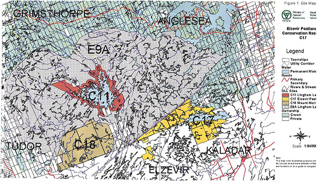
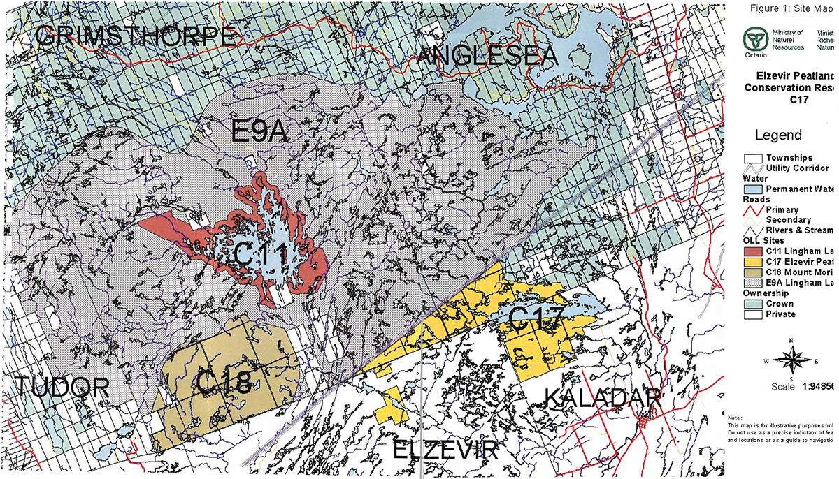
The Elzevir Peatlands Conservation Reserve (C17), located in Ecodistrict 5E-11, is a 2336 hectare area of Crown land and is approximately 30 kilometers north of the Village of Tweed. The western portion of the site is in Hastings County in the geographic townships of Grimsthorpe and Elzevir, while the eastern portion is located in the County of Lennox and Addington, geographic townships of Anglesea and Kaladar.
This conservation reserve protects a great portion of one of the largest peatland complexes in southern Ontario (OMNR, 2003). This same area has been identified as a provincially significant Area of Natural and Scientific Interest (ANSI) for its representation of a shallow peatland complex with upland barrens (Brunton, 1990). Elzevir Peatlands Conservation Reserve also encompasses Deerock Lake, a very popular lake for fishing and day tripping.
The site has a history of recreational use and resource management prior to being recommended as a conservation reserve through Ontario’s Living Legacy. It has been used for remote recreational activities and forest management, and has been managed under policies and legislation applicable to Crown land.
This Statement of Conservation Interest provides guidance for the management of the Elzevir Peatlands Conservation Reserve and provides the basis for the ongoing monitoring of activities.
Because the Elzevir Peatlands Conservation Reserve extends across portions of the Peterborough District and the Bancroft District of the Ministry of Natural Resources, administrative responsibility is shared between the two Districts.
Approved by:
Lois Deacon
District Manager
Peterborough District
Approved by:
Monique Rolf von den Baumen-Clark
District Manager
Bancroft District
Approved by:
Ron Running
Regional Director
Southern Region
1.0 Introduction
The Elzevir Peatlands Conservation Reserve (C17) consists of a 2336 hectare area of Crown land, approximately 30 kilometers north of the Village of Tweed. The western portion of the site is in Hastings County in the geographic townships of Grimsthorpe and Elzevir, while the eastern portion is located in the County of Lennox and Addington, geographic townships of Anglesea and Kaladar (see Figure 1: Site Map). This conservation reserve, located in Ecodistrict 5E-11 (previously known as ecological Site District 5E-11), is part of one of the largest peatland complexes in southern Ontario (OMNR, 2003). Private lands adjacent to or near the reserve boundary are not part of the reserve.
The reserve was identified as unique when Brunton (1990) described it, and the larger area around it, as the provincially significant 'Eizevir Peatlands and Barrens ANSI' (Area of Natural and Scientific Interest) for its representation of a shallow peatland complex with upland barrens.
The site has a history of recreational use and resource management prior to being recommended as a conservation reserve through Ontario’s Living Legacy. It has been used for recreational activities and forest management (guided by policies and legislation applicable to Crown land). The feature receiving the most recreational use is Deerock Lake, which is a locally popular warm water fishery.
The purpose of this Statement of Conservation Interest (SCI) is to identify and describe the values of the Elzevir Peatlands Conservation Reserve. The SCI also outlines the activities that occur within the reserve and provides guidelines for the management of current and future activities in the context of protecting the natural and cultural values.
Conservation Reserves are established by Regulation under the Public Lands Act. Statements of Conservation Interest are prepared under the authority of Procedural Guideline A - Resource Management Planning (PL Procedure 3.03.05).
1.1 Background information
| Name | Elzevir Peatlands Conservation Reserve |
|---|---|
| Ecoregion/Ecodistrict | 5E/5E-11 |
| OMNR Administrative Region/District/Area | Southern Region/ Bancroft District/Mazinaw Area, and Peterborough District/Peterborough Area & Kingston Area |
| Total Area | 2336 hectares |
| Regulation Date | March 2003 |
| First Nations Interests | Members of the Alderville First Nation, Hiawatha First Nation, the Kawartha Nishnabae and the Mohawks of the Bay of Quinte may have an interest |
| OBM map sheets | 10 18 3100 495050, 10 18 3100 49500, 10 18 3150 49550, 10 18 3150 49500, 10 18 3200 49550, 10 18 3200 49500 |
| UTM Coordinates | Zone 18 319000 4956000 (NAD 83) |
1.2 Representation/targets
This section provides a summary of the earth science, life science and cultural values represented in the site. It also outlines existing and potential recreational opportunities available.
Earth science representation:
The conservation reserve contributes the following earth science representation to Ontario’s system of protected areas:
Bedrock
Within the Ontario Provincial Park system, the geology of the Elzevir Peatlands Conservation Reserve has regional significance in its representation of felsic plutonic and sedimentary supracrustal components of the Grimsthorpe Domain of the Elzevir Terrane.
This representation also contributes to the conservation of the Grenville continental accretion theme outlined by Davidson (1981, p.107-111). (Duba and Frey, 2002)
Surficial geology
The surficial geology, including the recent organic deposits, is locally significant (Duba and Frey, 2002).
Life science representation:
The representation of a shallow peatland complex with upland barrens is considered provincially significant (Brunton, 1990).
Recreational resource representation:
Recreational opportunities are considered to be locally significant. Activities include fishing, camping, hiking, hunting, boating, All Terrain Vehicle (ATV) and snowmobile travel, bird watching and shore side lunch stops. (Scott, 2003)
Proximity to two other conservation reserves, Lingham Lake Conservation Reserve and Mount Moriah Conservation Reserve, may enhance the recreational appeal of Elzevir Peatlands for those who are seeking to have multiple and varied experiences with minimal distances between sites.
Cultural resources representation:
Cultural resource inventories have not been completed for this conservation reserve.
The conservation reserve is not situated within an area encompassed by a land claim.
First Nations that may have an interest in this area include Alderville First Nation and Hiawatha First Nation, both signatories of the Williams Treaty, the Kawartha Nishnabae and the Mohawks of the Bay of Quinte (Pers. comm. Lee, 2004).
1.3 Survey information
This section provides an overview of the inventories completed, their level of detail and any further inventory work required.
| Survey Level | Earth Sciences | Life Sciences | Cultural | Recreational |
|---|---|---|---|---|
| Reconnaissance | Checksheet. Duba, D. and E.D. Frey. 2002. | Checksheet. Mainguy, S. 2002. | N/A | Report. Scott, S. 2003 |
| Detailed | N/A | Inventory & report. North-South Environmental Inc., 2002 1995 ANSI Inventory. White, D.J., 1995 | N/A | N/A |
| Requirement (as resources permit) | None anticipated | Monitor values; Inventory and increase awareness of rare and SAR species, and values in the area of prov. sig. representation of peatlands and barrens | Reconnaissance inventory is highly recommended | Monitor use and impacts of use. |
*Note: all survey work requires permission to be granted prior to commencing (see Appendix 2 Procedural Guideline C Research Guidelines in Conservation Reserves.)
2.0 Values to be protected
This section provides a description of the key natural heritage values of the site and their condition relative to past and present resource use and management activities. It also addresses the sensitivity of these values to future land use and management activities.
2.1 Earth science
Earth science values are focused on features (bedrock and surficial) that represent the chronology of earth history in the province (Davidson, 1981).
The Elzevir Peatlands Conservation Reserve is one of the largest and most continuous peatlands in southern Ontario. The dominant rock types are Elzevir Suite tonalite and siliceous gneiss derived from metasedimentary protolith of the Grimsthorpe Domain, Elzevir Terrane in the central part of the Central Metasedimentary Belt of the Proterozoic Grenville Province.
The Grenville Province is the product of thrusting and imbrication of the crust to the northwest as it collided with a continental landmass to the southeast. The Grenville Orogeny, circa 1140 to 1070 million years ago, culminated more than 500 million years of crustal evolution. The eroded roots of the products of these events are displayed in the complexly metamorphosed and deformed rocks of the region (Easton in Duba and Frey, 2002).
The Elzevir Terrane is one of five lithotectonic terranes of the Central Metasedimentary Belt. Within the Elzevir Terrane, the Grimsthorpe Domain is one of three structural domains. This geological environment is part of the modern organization of the complex products of the mid-Proterozoic Grenville orogenic events (Easton in Duba and Frey, 2002). As such, its representation in the Elzevir Peatlands Conservation Reserve contributes to the conservation of the Grenville continental accretion theme outlined by Davidson (1981).
Surficial geology of the Elzevir Peatlands Conservation Reserve includes quaternary glacial deposits that are Late Wisconsinan in age, similar to other areas of southeastern Ontario. The regional ice flow direction was to the southwest. Uplands are covered by very thin and discontinuous sand till deposited as ground moraine on bedrock. It is usually stoney and sandy with the clasts reflecting local geology.
Recent organic deposits are abundant in the Elzevir Peatlands Conservation Reserve.
Within the Ontario Provincial Park system, the geology of the Elzevir Peatlands Conservation Reserve has regional significance in its representation of felsic plutonic and sedimentary supracrustal components of the Grimsthorpe Domain of the Elzevir Terrane. The surficial geology is locally significant.
2.2 Life science
The Elzevir Peatlands Conservation Reserve is located within Hill’s (1959) ecological Site District 5E-11, recently renamed Ecodistrict 5E-11.
Representation:
There is a great variety of waterbodies and wetlands in the Elzevir Peatlands Conservation Reserve.
Wetland types represented include shrub-rich poor fens, bogs, aquatic marsh, thicket swamp and aquatic marsh (North-South Environmental Inc., 2002).
The reserve protects portions of a larger area (i.e. Elzevir Peatlands and Barrens ANSI) that was recommended for designation as a provincially significant Area of Natural Science and Interest (ANSI) in 1990 (Brunton) for its representation of a shallow peatland complex with upland barrens. The large wetlands of the Elzevir Peatlands Conservation Reserve are not contiguous but they are noted for their cumulative size (Scott, 2003). Shrub rich poor fens occur in cool, wet sites where low ericaceous shrubs, sedges (Carex sp.); black spruce (Picea mariana) and tamarack (Larix laricina) are common. Palustrine and riverine wetlands support red maple (Acer rubrum) and silver maple (Acer saccarinum) swamps. (Mainguy, 2002)
Deerock Lake is shallow and supports an excellent warm water fishery of smallmouth bass (Micropterus dolomiew), largemouth bass (Micropterus salmoides), and northern pike (Esox lucius). Elzevir Lake, a cold water lake supports a put-grow-and take fishery of stocked splake (Salvelinus namaycush x fontinalis).
The terrain is rugged and strongly bedrock-controlled. The mixed forest is composed of white and red pine (Pinus strobus and P. resinosa respectively), white and red oak (Quercus alba, Q. rubra), red maple, balsam fir (Abies balsamea) poplar (Populus sp.) and white birch (Betula papyrifera). Dry rocky upland sites grade from scrubby red oak to white pine forest into rock barren on ridge tops. Deeper soils southeast of Deerock Lake provide habitat for sugar maple (Acer saccharum) and beech (Fagus grandifolia) forest. (Mainguy, 2002)
Wildlife and other plant species at the site are discussed below under Diversity.
Condition:
The species composition of the upland forests shows that there has been a history of wildfire disturbance. The conservation reserve is relatively unfragmented with few trails and no roads through it. It also benefits from being embedded in a rather remote and undeveloped area (i.e. Remote Access Enhanced Management Area E9a and Crown land to the north.)
Unmanaged campsite use on Deerock Lake is problematic. Many of the sites are scattered with garbage, human waste and makeshift structures built by campers. The islands and shore have very little soil over granite bedrock and therefore are sensitive to overuse (Scott, 2003). The accumulation of waste severely detracts from what could otherwise be a pleasant lunch or stopover site.
Diversity:
The popular warm water fishery of Deerock Lake supports smallmouth bass, largemouth bass and northern pike as well as white sucker (Catostomus commersom), brown bullhead (lctalurus nebulosus), rock bass (Ambloplites rupestris), yellow perch (Perea flavescens), bluegill (Lepomis macrochirus), pumpkinseed (Lepomis gibbosus), fallfish (Semotilus corporalis) and burbot (Lata Iota) (OMNR, 1972). Recent attempts to reintroduce walleye (Sander vitreus) do not appear to have been successful (Bobrowicz, 2003).
Large game mammals documented in the area include American black bear (Ursus americanus), white tailed deer (Odocoileus virginianus), Wapiti (Rocky Mountain Elk) (Cervus elaphus) and moose (Aices alces). Gray wolf (Canis lupus), coyote (Canis Jatrans) and their hybrid, and several other species of furbearing mammals including beaver (Castor canadensis) have been documented. (Scott, 2003)
The area supports a diverse assemblage of birds typical of central Ontario (Mainguy, 2002). Forty three species were observed in 2001 field surveys (North-South Environmental Inc., 2002). An active great blue heron (Ardea herodias) heronry is also present in a shallow bay off the north side of Deerock Lake.
Elzevir Peatlands Conservation Reserve supports a high diversity of forest, rock barrens and peatlands plants. Twelve regionally or locally significant plants have been documented in the Elzevir Peatlands [and Barrens ANSI] (Mainguy, 2002). Field searches by North-South Environmental Inc. in 2001 located the regionally rare Whorled Loosestrife (Lysimachia quadrifolia), Broad-leaved Water-milfoil (Myriophyllum heterophyllum) and Autumn Willow (Salix serissima), and the provincially rare Hypnum Moss (Hypnum curvifo/ium) (North-South Environmental Inc., 2002). David White (1995) noted Discoid Beggarticks (Bidens discoidea), Twin-scaped Bladderwort (Utricularia geminiscapa) and Virginia St. John'swort (Triadenum fraseri) as provincially significant plants (based on The Atlas of the Rare Vascular Plants of Ontario) within the current boundary. He also noted the following regionally significant plants within the current boundary: Dodder (Cuscuta gronovit), Mermaid Weed (Proserpinaca palustris), Bristly Catbriar (Smilax herbacea), and Horse Gentian (Triosteum aurantiacum).
Five-lined skink (Eumeces faciatus) a provincial and national species at risk (NHIC, 2004) has been reported from Deerock Lake (Bancroft District files). The range of five-lined skink and the habitat at the site are appropriate to support this observation.
A life science report by North-South Environmental Inc., (2002) contains detailed species and community lists that include those from Elzevir Peatlands Conservation Reserve.
Ecological considerations:
Bedrock and beaver dams have contributed to the discontinuous drainage at the site and influenced the pattern of peat development.
The water level of Deerock Lake is artificially high due to the dam at the outlet on the east end of the lake. Water level fluctuations on Deerock Lake are affected mostly by operation of the Skootamatta Lake dam upstream from the lake and minimally by the Deerock Lake dam.
Both water control structures are managed and maintained by Quinte Conservation Authority (QCA). Neither of these structures is in the reserve, but by controlling water levels, they have a significant effect on the conservation reserve values, especially those of Deerock Lake.
Vegetation and drainage patterns in the reserve show that fire and beaver activity have contributed to the development and maintenance of the current ecosystem.
Although the peat and decomposing peat are considered 'recent' organic deposits in geological time (Duba and Frey, 2002) peat mats are very slow to develop, taking many generations to accumulate into mats such as those in the reserve. If disturbed, peatlands are not easily restored (Mansell et al. 1998); hence conservation of these areas is a priority.
The remoteness of the reserve contributes to the conservation of values in the reserve. The remoteness helps to maintain native plant species by minimizing potential for the introduction of exotic species, and provides habitat for species needing large home ranges, interior or remote habitat. The shoreline and islands of Deerock Lake, which receive higher use, are more susceptible to influx of exotic species than other more remote areas of the reserve. This is because they are more easily accessed and therefore more frequented by users, thus increasing the opportunity for exotic seed introduction.
The undeveloped character of the remote access Enhanced Management Area E9a and Crown land surrounding the site enhance and contribute to the remote character of the site.
Special features:
The protection of the peatlands on the site contributes to the protection of one of the largest peatland complexes in southern Ontario (OMNR, 2003).
Elzevir Peatlands contains several plant species considered to be rare in Ecoregion 5E and Ecodistrict 5E-11 and provides habitat for at least one species at risk.
Significance:
The reserve protects portions of a larger area (i.e. Elzevir Peatlands and Barrens ANSI) that is considered provincially significant (Brunton, 1990) for its representation of a shallow peatland complex with upland barrens.
The reserve provides habitat for rare species (local, regional, provincial) and a national and provincial species at risk. (North-South Environmental Inc., 2002; Bancroft District Files).
2.3 Recreational values
Deerock Lake, at the northeast end of the reserve, is the largest lake in the reserve. As a well known local warm water fishery, it is the most predominant recreational feature in the reserve.
Elzevir Lake, a cold water fishery in the reserve with put-grow-take splake, is more difficult to access than Deerock Lake and receives less fishing pressure.
The peatlands, though perhaps better known for their ecological and representational value, provide a remote area and habitat which supports recreational activity such as hunting. These activities are described further in 3.3 Recreational Activities.
Snowmobile routes (and ATV during the summer) to and through the site link up with other routes such as the hydro corridor to the north, but these trails are not designated as Ontario Federation of Snowmobile Clubs (OFSC) routes.
Where access into the site is easier there is evidence of higher use (e.g. Deerock Lake) and where access and terrain is more difficult (e.g. peatlands to the south) areas show less evidence of use.
Demand for remote wilderness experiences and high quality fishing experiences such as is offered by Elzevir Peatlands Conservation Reserve will likely increase as populations and development increase.
Features with recreational value nearby include a southeast to northwest utility corridor (traveled by ATVs and snowmobiles); Bon Echo Provincial Park; Mount Moriah Conservation Reserve (C18); and Lingham Lake Conservation Reserve (C11).
Recreational activities are described in 3.3 Recreational Activities
3.0 Management guidelines
3.1 Land tenure
Background:
The Elzevir Peatlands Conservation Reserve consists entirely of Crown land. The reserve is composed of thirteen parts. Most parts are contiguous with one another with the exception of the municipal road allowances which pass through the site. There are nine municipal road allowances through the site, none of which are part of the conservation reserve. The most southerly part on the west is separated from the others by one lot. (Office of the Surveyor General, 2003)
There are five recreation camps authorized by land use permits within the reserve (Scott, 2003).
There are two Bear Management Areas (TW-61-006 and TW-61-005) and two registered trap lines (TW01-1084-17 and TW01-1084-14) within the reserve.
Other than the above mentioned, there are no land use permits, licenses or easements that apply to Crown land within the conservation reserve.
The conservation reserve is bordered by Crown land and private land, and a hydro line to the north.
Crown land northwest of the conservation reserve is designated as the Lingham Lake Remote Access Enhanced Management Area (E9a) in the Ministry’s Ontario’s Living Legacy Land Use Strategy (OMNR 1999). The land use intent for Enhanced Management Area E9a is to:
Maintain the remote access characteristics of this area, while also managing the area for forest management, recreation and other compatible uses. Road and other access to be limited to existing traditional access - any new roads will be retired and closed to new public travel. (OMNR, 1999)
Private lands adjacent to the reserve are not part of the reserve (see Figure 1: Site Map).
The Skootamatta Lake dam upstream from Deerock Lake and the dam at the outlet of Deerock Lake are managed and maintained by Quinte Conservation Authority (QCA). Neither of these structures is in the reserve, but by controlling water levels, they have a significant effect on the conservation reserve values, especially those of Deerock Lake.
Guideline:
Sale of Crown land within the conservation reserve is not permitted.
The conservation reserve will continue to be managed under the Public Lands Act. All activities within the conservation reserve shall be consistent with the Ministry’s conservation reserve policies and procedures and the Ontario’s Living Legacy Land Use Strategy (OMNR, 1999).
Existing private recreation camps are eligible for enhanced tenure but not for the purchase of lands. A decision to grant enhanced tenure or to transfer recreation camps will be addressed through a screening process. Should a recreation camp be voluntarily surrendered to the Ministry by the permittee, the Ministry will consider the long term benefit to this protected area of removing the improvements and may or may not re-issue the permit for a new recreation camp outside of the conservation reserve boundary.
Renewals of existing leases, land use permits or agreements are permitted.
New trails or the relocation of trails within the conservation reserve may be considered through planning exercises where no significant conflicts can be demonstrated (see 3.2 Existing/Proposed Development).
New public access roads are not permitted in Enhanced Management Area E9a (as outlined under Background in this section).
3.2 Existing/proposed development
Background:
Existing development on Elzevir Peatlands is limited to informal trails and recreation camps identified in 3.1 Land Tenure.
There is no designated entrance to the reserve and no road leading into the reserve. Official campsites have not been designated. Impact from unmanaged camping is already quite evident on the islands of Deerock Lake.
The Crown land north and west of the reserve is designated as the Lingham Lake Remote Access Enhanced Management Area (E9a) in the Ministry’s Ontario’s Living Legacy Land Use Strategy (OMNR 1999). The land use intent for this remote access Enhanced Management Area is described in 3.1 Land Tenure.
Guideline:
Development or the relocation of trails for a variety of activities may be considered through planning exercises where no significant conflicts can be demonstrated. Motorized vehicle use off of trails is generally not permitted; ATV and Snowmobile use off trail for direct retrieval of game is permitted. Development that protects the values of the site or enhances recreational value without detrimental impact on significant or sensitive values is permissible. Procedural Guideline B-Land Uses-Test of Compatibility (PL Procedure 3.03.05) (Appendix 1) can assist in assessing this.
New access roads are not permitted in the adjacent Lingham Lake Remote Access Enhanced Management Area E9a except for industrial purposes (see 3.1 Land Tenure). Therefore road access to the conservation reserve cannot be developed through Enhanced Management Area E9a.
3.3 Recreational activities
Background:
As discussed under 3.2 Existing/Proposed Development there are no roads through the reserve and no designated access point to the reserve. However, the site can be accessed by ATV or snowmobile from the hydro lines on the north and from a boat launch and parking area managed by Quinte Conservation Authority on the east side of Deerock Lake. Therefore activities within the site are associated with boating, ATV use, snowmobiling and hiking.
Known recreational activities include fishing, camping, hunting, boating, ATV and snowmobile travel, bird watching and shore side lunch stops. Fishing and camping are ranked as the two most popular activities in the conservation reserve. (Scott, 2003) Evidence of shoreline and island use for camping and lunch stops on shore locations and islands is quite evident as discussed under 2.2 Life Science-Condition.
There are five recreation camps, authorized by a land use permit, within the reserve. There are also seven or more recreation camps, authorized by land use permit on Crown land adjacent to the reserve. (Scott, 2003)
As discussed in 3.2 Existing/Proposed Development, although campsites have not been designated or developed, there is abundant evidence of camping and gathering on the islands of Deerock Lake.
Guideline:
Existing recreational uses are permitted to continue as long as they do not negatively impact the features needing protection. Management options to reduce negative impacts from unmanaged site use (e.g. damage to Deerock shore and islands from intensive and inappropriate use) should be investigated and in order to protect sensitive features and features of high recreational value.
Sport hunting and fishing will continue to be permitted, as outlined in 3.6 Natural Resource Stewardship. The existing recreation camps, authorized by Land Use Permits may continue as described in 3.1 Land Tenure.
Motorized vehicle use off of trails is generally not permitted; ATV and snowmobile use off trails is only permitted for direct retrieval of game.
New trails, or the relocation of trails, including the development of a public access point, may be considered through planning exercises where no significant conflicts can be demonstrated (see 3.2 Existing/Proposed Development).
3.4 Commercial activities
Background:
There are two registered trap lines (TW01-1084-17 and TW01-1084-14) in the conservation reserve.
There are two Bear Management Areas (TW-61-006 and TW-61-005) in the reserve.
Mining activities are not known to have occurred within the reserve.
There are no tourist operations within the reserve.
Guideline:
Existing land use permits may be renewed.
Fur harvest will be authorized to continue within the conservation reserve.
Bear Management Areas will continue to be authorized through existing regulations.
Conservation reserves do not permit mining, commercial forest harvesting, hydroelectric power development, the extraction of aggregate, peat, soils, or other industrial use. (Public Lands Act, Ontario Regulation 805/94).
New commercial activities must meet the requirements of Procedural Guideline B - Test of Compatibility (PL Procedure 3.03.05) (Appendix 1).
3.5 Aboriginal interests
Background:
The conservation reserve is not located within a land claim area.
Cultural resources inventories have not been completed for this conservation reserve.
First Nations groups that may have an interest in this area include Alderville First Nation and Hiawatha First Nation, (both signatories of the Williams Treaty), the Kawartha Nishnabae and the Mohawks of the Bay of Quinte (Pers. comm. Lee, 2004).
Guideline:
Future inventories and consultations with First Nations groups may help to identify new values in the Mount Moriah Conservation Reserve.
Hunting and fishing are permitted uses in conservation reserves.
Where appropriate, interested partners will be encouraged to undertake inventories and studies of the area. Any research in the conservation reserve must be approved prior to commencement (see 3.9 Research).
3.6 Natural resource stewardship
3.6.1 General
This conservation reserve will be managed with an emphasis on ensuring that the natural ecosystems and processes of the reserve are not negatively affected by current and future activities. Therefore, applications for specific uses will be carefully reviewed.
3.6.2 Vegetation management and fire management
Background:
The species composition of the upland vegetation shows that there is a history of wildfire in the reserve.
The peatlands on the site are part of the largest peatland complexes in Southern Ontario (OMNR, 2003). Peatlands and fens are extremely slow to develop therefore their protection is the best tool for their conservation. If peat accumulations dry (due to a change of surface water flow or a dry season) they may provide fuel for wildfires. If peatlands remain moist or wet, they can serve as a natural break for wildfires.
It is recognized that fire and beaver activity are natural components of ecosystems in the area.
Guideline:
In accordance with existing Conservation Reserve Policy and the Forest Fire Management Strategy for Ontario, forest fire protection will be carried out as on surrounding lands.
Whenever feasible, the MNR fire program will endeavour to use "light on the land" techniques, which do not unduly disturb the landscape, in this conservation reserve. Examples of light on the land techniques may include limiting the use of heavy equipment or limiting the number of trees felled during fire response efforts.
Opportunities for prescribed burning to achieve ecological or resource management objectives may be considered. These management objectives will be developed with public consultation prior to any prescribed burning, and reflected in the document that provides management direction for this conservation reserve. Plans for any prescribed burning will be developed in accordance with the MNR Prescribed Burn Planning Manual, and the Class Environmental Assessment for Provincial Parks and Conservation Reserves (approval pending).
Programs may be developed to control forest insects and diseases in the conservation reserve where these threaten significant values in or adjacent to the site. Similarly, programs may be developed to control exotic species in the conservation reserve where these threaten significant values in or adjacent to the site. Control will be directed to be as specific as possible to the insect, disease or exotic species. Biological control will be used wherever possible.
3.6.3 Fish and wildlife management
Background:
Wildlife species are discussed under in the 2.2 Life Science - Diversity.
Commercial and recreational activities related to wildlife are listed in 3.3 Recreational Activities and 3.4 Commercial Activities.
The conservation reserve provides habitat for a species that is nationally and provincially rare (Bancroft District Files).
Guideline:
The management of game and fur species in the Elzevir Peatlands Conservation Reserve will continue to be consistent with Wildlife Management Unit 61 within which it lies. The management of fish species will continue to be consistent with the fisheries management program in the surrounding area.
Significant or rare species and their habitat will be protected through appropriate planning and management of the conservation reserve, including but not limited to the monitoring of impacts on the site, directing site use and review of development proposals as per Procedural Guideline B - Test of Compatibility (PL Procedure 3.03.05) (Appendix 1).
3.7 Cultural resource stewardship
Background:
Cultural resource values have not yet been identified within the Elzevir Peatlands Conservation Reserve.
Guideline:
Where appropriate, interested partners will be encouraged to undertake inventories and studies of the area. Any research in the conservation reserve must be approved prior to commencement (see 3.9 Research).
3.8 Client service
Background:
Client service for Elzevir Peatlands Conservation Reserve is currently limited to a fact sheet that is available at the Ministry of Natural Resources, Bancroft District Office and Peterborough District Office.
Access to the conservation reserve can be gained from the southeast side of Deerock Lake from which Quinte Conservation manages a boat launch outside of the conservation reserve. A fee is charged for its use. Outdoor privies and parking areas are also provided.
On the north side of the reserve a few ATV trails are found between the hydro corridor right-of-way, which runs adjacent to the northern boundary of the CR, and Deerock Lake (North-South Environmental Inc., 2002). Access to the south side of the reserve is minimal due to the extensive wetlands and rough terrain.
There is no signage identifying the site as a conservation reserve or delineating the boundaries of the reserve.
There are no roads through the conservation reserve; hence access is associated with travel by boat, ATV, snowmobile or foot. Trails within the site are unmarked. Campsites are unofficial and there are no privies on site. Because campsite maintenance is not provided, responsible user etiquette is necessary for this approach to succeed.
Snowmobile routes through the site link up with other routes (e.g. the hydro corridor to the northeast) but the trails are not Ontario Federation of Snowmobile Clubs (OFSC) routes, nor are they maintained by local snowmobile clubs.
An Ontario Living Legacy fact sheet on Elzevir Peatlands Conservation Reserve is provided at the Peterborough District and Bancroft District Area Ministry of Natural Resources offices.
Guideline:
Although there is no proposal to build facilities or expand services from the current level, development which enhances resource protection or recreational value or safe use may be considered (see 3.2 Development).
At present, the focus of client service at the site will remain on the provision of low key information and self-guided interpretation of conservation reserve values. If funding permits, signage where appropriate (e.g. designated campsites, no-camping zones, user etiquette) is recommended. In particular, management options such as maintained privies should be considered to protect the islands on Deerock Lake from unmanaged and inappropriate use.
Maintaining remoteness of the provincially significant peatlands and rock barrens in the south side of the reserve is a priority for the conservation of the ecological integrity of the peatlands as well as to maintain the remote recreational value of the area. Therefore new trails or roads should not be developed through these remote areas.
3.9 Research
Background:
Since the Ontario’s Living Legacy Land Use Strategy (OMNR. 1999) designation of the site as a conservation reserve, several surveys and checklists have been completed by the Ministry. A reconnaissance Earth Science Checksheet (Duba and Frey, 2002), a reconnaissance Life Science Checksheet (Mainguy, 2002) and a Recreation Report (Scott, 2003) were completed based on field surveys. Elzevir Peatlands was also included in a detailed inventory including three conservation reserves (Lingham Lake, Mount Moriah and Elzevir Peatlands) and the intervening lands (NorthSouth Environmental Inc., 2002).
Guideline:
Authorized inventory of cultural/historic and archeological values is encouraged so that these values can be appropriately protected. The potential for existing cultural and historical sites as well as for archeological features warrants a cultural survey (Andersen in Scott 2003).
Continued monitoring and research of recreational use and natural heritage values is encouraged. Recommended studies are outlined in a chart in 1.2 Survey Information.
All research proposals and activities must follow Procedural Guideline C- Research Activities in Conservation Reserves (PL. Procedure 3.03.05) (Appendix 2).
3.10 Marketing
Background:
There has been no direct marketing of the Elzevir Peatlands Conservation Reserve to date. Promotion and information about this site has been primarily through the Ontario’s Living Legacy land use planning process, and recent MNR public consultation (2003) regarding regulation and boundary refinement of this site.
Guideline:
Fact sheets about this conservation reserve will continue to be available to inform the public about the special values of this area and the role of this conservation reserve in Ontario’s protected area system. Further marketing of the site is not anticipated.
4.0 Implementation
Administrative responsibility for the Elzevir Peatlands Conservation Reserve lies with the Ministry of Natural Resources through the Peterborough and Kingston Area Teams in Peterborough District and the Mazinaw Area Team in Bancroft District.
Implementation of this Statement of Conservation Interest will primarily involve survey and monitoring activities to ensure adherence to the management guidelines. These activities will be considered for implementation as resources and opportunity permit.
Implementation priorities include:
- survey cultural values;
- consult with First Nations that may have an interest in the site;
- review management options (e.g. privies, restricted camping, signage) to protect site from inappropriate use or overuse;
- monitor site use and impacts of use;
- continue recreation assessment and documentation (e.g. GPS map existing trails, assess winter usage);
- survey for additional natural heritage values such as rare species and species at risk, preferably in partnership with reserve users or researchers;
- consider acquisition of lands identified as the Elzevir Peatlands and Barrens ANSI (Brunton, 1990; White, 1995) as they come up for sale; and
- continue to provide a fact sheet on Elzevir Peatlands Conservation Reserve at Ontario Ministry of Natural Resources, Peterborough District and Bancroft District offices.
5.0 Review and revision of the Statement of Conservation Interest
The Elzevir Peatlands Conservation Reserve Statement of Conservation Interest (SCI) will be reviewed on an ongoing basis.
If changes are required to the Statement of Conservation Interest, they will occur through a standard process of minor and major amendments. Minor amendments will be processed in a relatively informal manner on the approval of the appropriate MNR Area Supervisor. These amendments will deal with uses and activities that do not affect any of the policies in this SCI, such as new uses and/or activities that are consistent with existing policies.
Uses and/or activities that were not anticipated in the approved SCI and which have the potential to have a negative impact on the values of this conservation reserve will require a major amendment. This will include an opportunity for public comment and input, and will require the approval of the Bancroft District Manager, Peterborough District Manager and Regional Director, Southern Region, OMNR.
References
Bobrowicz, S. 1993. Mazinaw Area CFWIP Walleye Fry Stocking Assessment July/August 2002 & 2003 Project Summary. Unpublished report. Ministry of Natural Resources, Bancroft District.
Brunton, D. 1990. Life Science Areas of Natural and Scientific Interest in Site District 5-11. Ontario Ministry of Natural Resources, Eastern Region, Kemptville.
Crins, W.J. 2002a. Regionally Rare Vascular Plants- Site Region 5E. Ministry of Natural Resources, Peterborough.
Crins, W.J. 2002b. Locally Rare Vascular Plants- Site District 5E-11. Ministry of Natural Resources, Peterborough.
Davidson, R.J. 1981. A framework for the conservation of Ontario’s earth science features. Ontario Ministry of Natural Resources, Toronto.
Duba, D. and E. Frey. 2002. Earth Science Report, Elzevir Peatlands Conservation Reserve (C17). Ontario Ministry of Natural Resources, Bancroft.
Hills, G.A. 1959. A ready reference to the description of the land of Ontario and its productivity. Ontario Department of Lands and Forests, Division of Research, Maple.
Lee, S. 2004. Personal Communication with Scott Lee, Resource Liaison Specialist. Ontario Ministry of Natural Resources, Kemptville. March 4, 2004.
Mainguy, S. 2002. Life Science Checksheet, Elzevir Peatlands Conservation Reserve (C17). Ontario Ministry of Natural Resources, Bancroft.
Mansell, W.O., L. Christl, R. Maher, A. Norman, N. Patterson and T. Whillans. 1998. Temperate Wetlands Restoration Guidelines. Ontario Ministry of Natural Resources, Environment Canada (Canadian Wildlife Service) and Ducks Unlimited Canada, Barrie.
Municipality of Tweed. 2001. Municipality of Tweed website. Accessed: January 16, 2004.
NHIC. 2004. Natural Heritage Information Center (NHIC) Database: /page/natural-heritage-information-centre. Accessed: January, 2004.
North-South Environmental Inc. 2002. Lingham Lake - Mount Moriah - Elzevir Peatlands Life Science Inventory. Unpublished report and CD data for the Ontario Ministry of Natural Resources, Bancroft District.
Noble T.W., 1983. Biophysiographic Analysis of Site Region 5E. Central (Algonquin) Region, Ontario Ministry of Natural Resources.
Office of the Surveyor General. 2003. Plan of C17 Elzevir Peatlands Conservation Reserve, January 2003. Ontario Ministry of Natural Resources. (Note: not a plan of survey)
OMNR. 1972. Lake Survey Summary Sheet for Deerock Lake. Compiled by R. Beecher and R. Marchen. Ontario Ministry of Natural Resources, Bancroft.
OMNR. 1983. Tweed District Land Use Guidelines. Tweed District, Algonquin Region, Ontario Ministry of Natural Resources.
OMNR. 1999. Ontario’s Living Legacy Land Use Strategy, July 1999. Ontario Ministry of Natural Resources, Peterborough.
OMNR. 2002. Crown Land Use Atlas - Policy Report. Ontario Living Legacy Web-site: http://www.ontariolivinglegacy.com/crownlanduseatlas (link no longer active) Accessed: January 2004. Last updated October 28, 2002.
OMNR. 2003. Elzevir Peatlands Conservation Reserve (C17) Fact Sheet, July 2003. Ontario Ministry of Natural Resources, Bancroft District.
OMNR. 2004. Natural Resource Values Information System (NRVIS). Accessed: January and February, 2004.
Scott, S. 2003. Recreation Inventory Report: Elzevir Peatlands Conservation Reserve (C17). Ontario Ministry of Natural Resources, Bancroft.
White, D.J. 1995 Life Science Survey and Evaluation of the Elzevir Peatlands and Barrens Candidate ANSI., Ontario Ministry of Natural Resources, Tweed District.
Appendix 1 - Procedural guideline B - Land uses-Test of Compatibility (PL procedure 3.03.05)
The Conservation Reserve policy provides broad direction with regard to the permitted uses. The policy provides only an indication of the variety of uses that will be considered acceptable in Conservation Reserves. The only caution is that "any new uses, and commercial activities associated with them, will be considered on a case by case basis, and, they must pass a test of compatibility to be acceptable."
What does a 'test of compatibility' mean? An examination of this must start from the premise of why an area is set aside - specifically, its representative natural heritage values. Criteria are then identified to guide compatibility considerations. These criteria apply to the long-term acceptability of both existing uses and new uses.
-
Conformity to SCI/RMP: SCI describe values for which an area has been set aside and the range of appropriate uses that will be permitted in the area. SCI may also speak to the acceptability of other 'new' uses currently not occurring in the area.
The first 'test' is: "do proposed new land uses and/or commercial activities conform to the direction of the SCI/RMP for the conservation reserve? Would the new use(s) depart from the spirit of appropriate indicator land uses in the SCI/RMP?"
- Impact Assessment: If the proposed use(s) pass test 1 it is important to determine their impact on the area before they are approved. This should include the following:
- Impact on natural heritage values: "will the new use(s) impact any natural values in the area? If so how and to what degree? Is it tolerable?"
- Impact on cultural values: "will the new use(s) impact an historical or archaeological values in the area?"
- Impact on research activities: "will the new use(s) affect research activities in the area?" Impact on current uses: "will the new use(s) have any negative impact on the array of current uses?"
- Impact on area administration: "will the new use(s) increase administrative costs and/or complexity?" (For example, the cost of area monitoring, security and enforcement).
- Impact on accommodating the use outside the conservation reserve: "Could the use(s) be accommodated as well or better outside the conservation reserve?"
- Impact on socio-economics of the area: "will the new use(s) affect the community(ies) surrounding the area in a positive or negative way?" (For example, will the new use make an area less remote thereby affecting a local tourism industry that is dependent on the area’s remoteness for its appeal?"
- Impact on area accessibility: "does the new use(s) give someone exclusive rights to the area or a portion of the area to the exclusion of other existing uses?"
Indicator uses for Conservation Reserves
Industrial activities
| Activity | Generic OLL policy permitted? Existing | Generic OLL policy permitted? New | Specific Application Elzevir Peatlands Conservation Reserve - Existing |
Specific Application Elzevir Peatlands Conservation Reserve - New |
|---|---|---|---|---|
| Commercial timber harvest | No | No | No | No |
| Cutting of trees by leaseholders and property owners for fuelwood and small-scale uses | Maybe | Maybe | Maybe | Maybe |
| Timber salvage/sunken log retrieval | Maybe | Maybe | Maybe | Maybe |
| Mineral exploration | No | No | No | No |
| Mining | No | No | No | No |
| Extraction of peat, soil, aggregate, other materials | No | No | No | No |
| Forest renewal | Maybe1 | Maybe1 | Maybe1 | Maybe1 |
| Hydro power generation | No | No | No | No |
| Communications corridors | Yes | No2 | Yes | No2 |
| Energy transmission corridors | Yes | No2 | Yes | No2 |
| Transportation corridors | Yes | No2 | Yes | No2 |
| Resource access roads | Maybe2 | Maybe2 | Maybe2 | Maybe2 |
| Private access roads | Yes | No3 | Yes | No3 |
Recreation Activities
| Activity | Generic OLL policy permitted? Existing | Generic OLL policy permitted? New | Specific Application Elzevir Peatlands Conservation Reserve - Existing |
Specific Application Elzevir Peatlands Conservation Reserve - New |
|---|---|---|---|---|
| Sport fishing | Yes | Yes | Yes | Yes |
| Sport hunting | Yes | Yes | Yes | Yes |
| Facility development | Maybe | Maybe | Maybe | Maybe |
| Non-trail snowmobiling | Maybe4 | Maybe4 | Maybe4 | Maybe4 |
| Non-trail ATV use | Maybe4 | Maybe4 | Maybe4 | Maybe4 |
| Motorized boating | Yes | Yes | Yes | Yes |
| Camping | Maybe | Maybe | Maybe | Maybe |
| Trails: - hiking - snowmobiling - cycling - horse riding - cross-country skiing |
Yes | Maybe | Yes | Maybe |
| Private recreation camps | Yes5 | No | Yes5 | No |
Commercial activities
| Activity | Generic OLL policy permitted? Existing | Generic OLL policy permitted? New | Specific Application Elzevir Peatlands Conservation Reserve - Existing |
Specific Application Elzevir Peatlands Conservation Reserve - New |
|---|---|---|---|---|
| Fishing | Yes6 | Maybe | Yes6 | Maybe |
| Bait-fish harvesting | Yes6 | Maybe | Yes6 | Maybe |
| Commercial fur trapping | Yes6 | Maybe | Yes6 | Maybe |
| Trapping cabin | Yes | No | Yes | No |
| Out-post camps/tourism facilities | Maybe7 | Maybe7 | Maybe7 | Maybe7 |
| Commercial bear hunting (tourist operators) | Yes | No | Yes6 | No |
| Wild rice harvesting | Yes6 | Maybe | Yes6 | Maybe |
| Food harvesting | Maybe | Maybe | Maybe | Maybe |
Resource management activities
| Activity | Generic OLL policy permitted? Existing | Generic OLL policy permitted? New | Specific Application Elzevir Peatlands Conservation Reserve - Existing |
Specific Application Elzevir Peatlands Conservation Reserve - New |
|---|---|---|---|---|
| Resource inventorying | Yes | Yes | Yes | Yes |
| Resource monitoring | Yes | Yes | Yes | Yes |
| Fire protection | Yes | Yes | Yes | Yes |
| Insect and disease | Maybe | Maybe | Maybe | Maybe |
| Featured species management | Maybe | Maybe | Maybe | Maybe |
Other activities
| Activity | Generic OLL policy permitted? Existing | Generic OLL policy permitted? New | Specific Application Elzevir Peatlands Conservation Reserve - Existing |
Specific Application Elzevir Peatlands Conservation Reserve - New |
|---|---|---|---|---|
| Research | Yes | Yes | Yes | Yes |
| Collecting | Maybe8 | Maybe8 | Maybe8 | Maybe8 |
| Food gathering | Yes | Yes | Yes | Yes |
| Land disposition | Yes9 | Yes9 | Yes9 | Yes9 |
| Habitat management for wildlife | Maybe10 | Maybe10 | Maybe | Maybe |
Appendix 2 - Procedural guideline C - Research activities in conservation reserves
Purpose
To encourage contributions to the goal of conservation reserves by:
- providing direction for research activities associated with conservation reserves; and
- establishing a process for the review and approval of proposals by researchers, which could have an impact on the values protected by the conservation reserve.
Definition
Research means any investigation or study of the natural, cultural, social, economic, management or other features or characteristics of conservation reserves.
Guidelines
Research will be encouraged to provide a better understanding of the natural values protected by a conservation reserve and to advance their protection, planning and management. The Statement of Conservation Interest will define, for each conservation reserve, the key research issues, set out the parameters within which research may occur and identify research needs.
Applications and approvals
Researchers must apply in writing to the Area Supervisor for permission to conduct research. The request letter must contain a statement explaining why the proposed research should be undertaken in the particular conservation reserve in preference to another location.
Proposals will be reviewed and approved by the Area Supervisor, guided by the Statement of Conservation Interest prepared for each reserve (see Guideline A- Resource Management Planning) and using Guideline B-Land Uses- Test of Compatibility. Permission must be granted in writing, including any conditions to be met in conducting the research, prior to the undertaking of any research project.
Terms and conditions
Permission to conduct research under this policy will be valid for a period of 12 consecutive months from date of issue. Permission to continue a research project for additional periods of 12 months or less may be granted upon submission of a written request and progress report. The Ministry may require the posting of collateral to assure that the terms and conditions of granting permission are met.
The Area Supervisor may suspend or revoke permission at any time for failure on the part of the researcher to meet:
- The intent or conditions of this policy.
- The requirements under the Public Lands Act, including all amendments, where applicable.
- The requirements under any other Act or Regulations of Ontario or Canada, including those governing the taking, handling, storing, confining, trapping, excavating and marketing any specimen, artifact, information or action (for example, scientific collector’s permit).
- The conditions and agreements specified in granting permission.
Final report
The researcher will submit copies of reports, publications and theses following from the results of the project to the Area Supervisor.
Figure 1: Site Map
1If a new conservation reserve has been recently cut, companies have an obligation to proceed with renewal. It can be conducted where it will be of net benefit to the protected area and to, the greatest extent possible, it should be designed to replicate natural conditions.
2The intent is to actively discourage these uses, but it is recognized that in some circumstances these will be no alternative; this will be determined through planning.
3New private access roads, including additions to existing roads, will not be permitted except where there are previous commitments that were made prior to March 29, 1999. Such commitments will be subject to the completion of a public planning process.
4Use may be permitted for the direct retrieval of game only.
5Existing private recreation camps are eligible for enhanced tenure but not for the purchase of lands. A decision to grant enhanced tenure, or to transfer recreational camps will be addressed though a screening process.
6Existing use permitted to continue, unless there are significant demonstrated conflicts. New operations can be considered, subject to the 'test of compatibility.'
7Existing authorized tourism facilities can continue unless there are demonstrated conflicts. The operators of tourism facilities can apply to upgrade tenure from LUP to lease. New tourism facilities can be considered during planning for a conservation reserve.
8Must be part of an authorized research project.
9Sale of lands is not permitted with the exception of some minor types of dispositions where it does not detrimentally affect the values an area is intended to protect. Renewals of existing leases or land use permits are permitted. Requests for transfer of tenure will be considered in the context of the SCI. New leases or land use permits will be allowed for approved activities.
10A specific policy was not identified in the OLL Land Use Strategy, although specific management prescriptions will be identified in the context of an SCI.