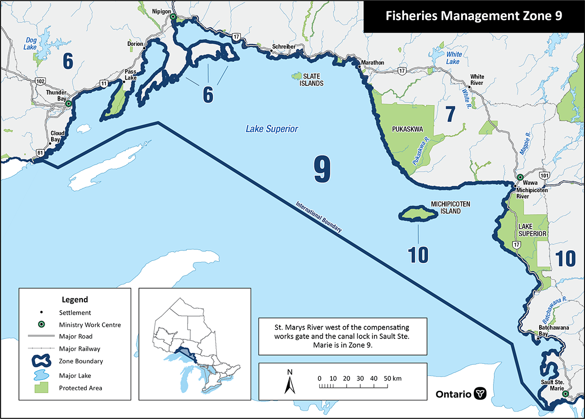
Fisheries Management Zone 9 (FMZ 9)
Information about fishing and how fish resources are managed in Fisheries Management Zone 9 (Lake Superior).
News and updates
Summary of Black Bay Fisheries Management Plan consultation
The consultation process for the Black Bay Fisheries Management Plan (BBFMP) is now closed. A decision was made to finalize the BBFMP and implement new regulations for walleye and Northern pike in Black Bay, which will come into force on January 1, 2026. The new regulations offer:
- a balanced approach to stakeholder views and support
- a conservative reopening of the walleye fishery to allow for monitoring and adaptive management
Consultation to support the development and finalization of the BBFMP included:
- a Proposal Notice on the Environmental Registry
- a targeted email with online survey
- outreach to Indigenous communities and stakeholders
Environmental Registry posting
- The draft BBFMP was posted on the Environmental Registry of Ontario (ERO) from August 21 to September 22, 2025.
- 41 comments were received through the posting.
- Most feedback supported reopening the walleye fishery but expressed concerns that the proposed slot size is too restrictive.
- Opposition focused on removing the ice fishing opportunity and concerns about walleye recovery due to habitat limitations.
- Some stakeholders supported the plan while others raised concerns about habitat and population recovery.
Targeted email and online survey
- A survey was published on Ontario.ca and emailed to 25,000 recreational fishing licence holders in Northwestern Ontario for input.
- 582 anglers responded to the survey. Of those who responded:
- 46.1% supported or strongly supported the walleye proposal and 34.5% opposed or strongly opposed
- 43.5% supported the Northern pike proposal and 16.5% opposed
- Opposition largely favoured reopening the walleye fishery but sought less restrictive regulations.
Outreach to Indigenous communities and stakeholders
Indigenous communities, stakeholders, associations, non-governmental organizations and agencies were engaged throughout the consultation process for the BBFMP.
Outreach included:
- inviting participation on a working group
- sharing information
- inviting feedback
- holding community-specific consultation
- incorporating perspectives from diverse groups to support collaborative stewardship of fisheries resources
Thank you to everyone who provided input and shared their perspectives. Check this page for more news and updates.
About this zone
FMZ 9 includes the Canadian waters of Lake Superior. This zone has:
- the largest surface area of any freshwater lake in the world
- some of Lake Superior’s most unique aquatic and terrestrial environments
- provincially and nationally protected features, including the proposed Lake Superior National Marine Conservation Area
- important Indigenous, recreational, commercial and tourism-based fisheries
- prominent fisheries for native lake whitefish, (coaster) brook trout, lake trout, walleye and yellow perch, as well as introduced species such as Chinook salmon, coho salmon and rainbow trout in both the open waters and tributaries
- an active commercial fishery that currently targets cisco, lake whitefish, and lake trout
FMZ 9 is one of 20 fisheries management zones in the province.
Location
FMZ 9:
- its northwestern boundary is the international border at the Pigeon River
- bordered to the southeast by the compensating works on the St. Mary’s River in Sault Ste. Marie
- its southern boundary is the Canada – US border dividing Lake Superior
- includes the Lake Superior islands other than St. Ignace and Simpson Islands (FMZ 6) and Michipicoten Island (FMZ 10)
- boundaries extend, in most cases, across river mouths of Lake Superior tributaries
- cities include Thunder Bay and Sault Ste. Marie, as well as the towns of Dorion, Red Rock, Nipigon, Rossport, Schreiber, Terrace Bay, Marathon and Wawa
Legal boundary map and detail maps
Legal boundary map for FMZ 9 and detail maps 1 - 25 (PDF)
Monitoring reports and management plans
- Joint strategic plan for management of Great Lakes fisheries
- Fish community objectives for Lake Superior
- A stocking plan for the Ontario waters of Lake Superior
Zone advisory council
The FMZ 9 council provides advice during the development of fisheries objectives and strategies.
Council members represent a broad range of views including:
- Indigenous interests
- angling and commercial fishing groups
- scientists and researchers
- conservation groups
- interested community members
The advisory council participates in fisheries management by:
- sharing ideas and expertise with the ministry
- helping to develop and implement management strategies
- communicating with the local angling communities
For more information about the Fisheries Management Zone 9 advisory council, please contact the Upper Great Lakes management unit at
Walleye population monitoring and rehabilitation in Black Bay
Black Bay is a large bay on the north shore of Lake Superior.
Before the 1960s, Black Bay was the site of the lake’s largest commercial walleye fishery. Intense commercial and recreational harvest of walleye, and loss of access to the upper Black Sturgeon River’s spawning habitat, may have played a role in the:
- collapse of the walleye population in the bay
- failure of the walleye population to fully recover
Since 2016, we have been researching walleye spawning locations and movements within Black Bay and into Lake Superior to confirm where walleye are spawning in Black Bay and in the river below the dam. Ongoing research results show signs that walleye are recovering from historically low numbers, and we will continue to track the population’s recovery. This research will help us determine how to protect and recover the walleye population.
The current level of sea lamprey control provided by the Camp 43 Dam continues, after the repairs were completed in late 2020. This aligns with our commitment to control the spread of invasive aquatic species in Ontario.
