Fishnet Lake Conservation Reserve Management Statement
This document provides policy direction for the protection, development and management of the Fishnet Lake Conservation Reserve and its resources.
Statement of Conservation Interest
November 2001
Prepared for the Ontario Ministry of Natural Resources
Nipigon District
by Rebecca Zeran
OLL Resource Manager
Approval page
Statement of Conservation Interest for Fishnet Lake Conservation Reserve C2217
Nipigon District
Northwest Region
The purpose of this Statement of Conservation Interest is to identify the natural heritage values of the Conservation Reserve and to identify the activities which occur at this location. This Statement outlines the activities which will be permitted and those which will be prohibited. From this outline, the management direction for the site can be determined.
Approved:
Ian Hagman
District Manager
Nipigon District
Date:
February 21, 2002
Approved:
Ralph Wheeler
Acting Regional Director
Northwest Region
Date:
May 17, 2002
1. Introduction
On July 16, 1999, the Ontario Government released Ontario’s Living Legacy (OLL) Land Use Strategy (LUS) to guide the planning and management of Crown Lands within a large part of northern and central Ontario. A major component of this Land Use Strategy was the establishment of 378 new protected areas in this part of Ontario. This commitment will be the largest expansion of Provincial Parks and other protected areas in the history of Ontario.
The Fishnet Lake Conservation Reserve (C2217) is one site within this expansion of Ontario’s protected areas.
Conservation Reserves are areas of Crown land set aside by regulation under the Public Lands Act to complement provincial parks in protecting representative natural areas and specific landscape features. Most recreational activities (e.g. hiking, skiing, tourism related uses, nature appreciation) and non-industrial commercial activities (e.g. fur harvesting, bait fishing and commercial fishing) that have traditionally been enjoyed in the area will continue – provided that these uses do not impact upon the natural features requiring protection. Recreational hunting and fishing are permitted uses within all new conservation reserves identified through the OLL Land Use Strategy. Commercial timber harvesting, mining, aggregate extraction and hydroelectric development are prohibited in conservation reserves.
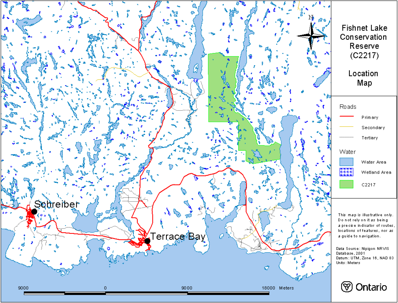
The Fishnet Lake Conservation Reserve, located approximately 15 kilometres northeast of the Town of Terrace Bay, contains representative landform and vegetation types, including mixed conifer forest with some deciduous on weakly, moderate and strongly broken ground moraine (LUS, 1999). More detail is available in the attached Earth Science Report and Life Science Report (Appendices 6 & 7).
Access to the site is best gained at its eastern and northern boundaries via boat or canoe from Cairngorm Lake (in the north) or Santoy Lake (in the east). Santoy Lake, part of the Steel River Loop canoe route, has a road access point at its southern end.
The purpose of this Statement of Conservation Interest is to identify the natural heritage values of Fishnet Lake Conservation Reserve; this Statement also intends to identify the activities occurring within the reserve. Through a set of management guidelines, this statement will outline the activities which will be permitted and those which will be prohibited. From this outline, the management direction for the area can be determined.
2. Background information
| Name | Fishnet Lake Conservation Reserve |
|---|---|
| Site Region / Site District | 3W-5 |
| OMNR Administrative Region / District / Area | Northwest/Nipigon/Terrace Bay-Nipigon East Area |
| Total Area (ha) | 3,503 ha |
| Regulation Date | April 6, 2001 |
| Interested First Nations | Pays Plat, Long Lake 58, Ginoogaming and Ojibways of the Pic River. |
| Lat./Long. (for Fishnet L.) | Latitude: 48°52' and Longitude: 86°56' |
| Basemap | |
| FRI Stands | Specific numbers for the FRI stands occurring within the conservation reserve can be obtained by contacting the Information Management Team in Nipigon or Geraldton |
| General Location | Located approximately 15 kilometres northeast of the Town of Terrace Bay – eastern boundary of the reserve is adjacent to Steel River Provincial Park |
| Access | The area is best accessed by canoe or boat via Santoy Lake |
3. Representation targets
This section provides a summary of the earth science, life science and cultural resource values represented in the site. It also outlines existing and potential recreational opportunities available.
| Life Science Representation | Uniform white birch dominated mixedwood forest on strongly broken terrain covers most of the reserve and is representative of the north shore of Lake Superior. Most of the forest is even-aged and is greater than 90 years old. Small areas of wetland and a network of small lakes are also present within the site. |
|---|---|
| Earth Science Representation | Two main groups of bedrock: granitic rocks in the North and volcanic/meta-sedimentary rocks in the South. A few sections are intruded by Proterozoic diabase dikes which are often associated with extraordinary repeating sets of vertical faults. The Southern parts of the reserve contain rocks with high mineral potential. |
| Cultural Resource Representation | No documented cultural resources. |
| Recreational Opportunities | Opportunities exist for wildlife viewing, hiking, canoeing, hunting and fishing. A well recognized portage trail, part of the Steel River Canoe Loop, passes through the lower eastern end of the reserve. |
4. Survey information
This section provides an overview of the inventories completed, their level of detail and any further inventory work required.
| Survey Level | Life Science | Earth Science | Cultural | Recreational |
|---|---|---|---|---|
| Reconnaissance | Yes, Nov. 2001 | Yes, Nov. 2001 | No | Yes, Nov. 2001 |
| Detailed | No | No | No | No |
| Requirement | No further requirement | No further requirement | No further requirement | No further requirement |
5. Natural & cultural heritage values
This section provides a description of the key natural and cultural heritage values of the site and their condition relative to past and present resource use and management activities. It also addresses the sensitivity of these values to future land use and management activities.
The intent of this Statement is to protect those values identified in the site, by establishing guidelines for existing and potential uses of the area, given the level of past disturbances and the nature of existing features.
Forest values
The entire forest area is to be protected from human disturbance. The forest cover on this site is representative of the surrounding area and is predominately fire origin mature stands. The conservation reserve is dominated by relatively even-aged forests (most trees are estimated to be greater than 90 years of age) with no recent fires and that the absence of fire has contributed to a low diversity of habitats (Harris & Foster, 2001). Uniform white birch mixedwood forest covers most of the reserve. Much of the balsam fir component has died following recurrent spruce budworm defoliation (Harris & Foster, 2001).
Geologic values
Chosen, in part, for its representative landform features, Fishnet Lake Conservation Reserve demonstrates spectacular topographic patterns. Visible from the air are hills, valleys, and water. The fault and bedrock controlled topography includes severe terrain and several straight, narrow and steep-sided valleys. The site also contains rounded hills with well-exposed Granitic bedrock crests. There is an interesting change in topographic relief to an S-formation, where the bedrock changes to mafic and volcanic intrusives (Gauthier, 2001, ES notes). The rugged terrain encountered in the reserve is typical of the north shore of Lake Superior.
Fish & wildlife values
Habitat conditions exist for moose, beaver, marten, mink, wolf, fox, otter, fisher, black bear, rabbit, and various species of waterfowl, as well as the following bird species: common loon, common merganser, spotted sandpiper, hairy woodpecker, Swainson’s thrush, red-eyed vireo, yellow-rumped warbler, black-throated green warbler, chipping sparrow and purple finch.
Recreation & tourism values
Due to the site’s proximity to Hwy 17, the Steel River Provincial Park and the road access point to Santoy Lake, the area has significant recreational potential. Apart from the use derived from these sources, the area also has the potential for hunting and fishing activities. Fishnet Lake and Box Lake have been actively fished for many years. While the majority of the conservation reserve has not been identified as having any evidence of traditional tourism use, the lower eastern end does contain the canoe portage route from Santoy Lake to Diablo Lake. This portage is part of the Steel River Loop canoe route and is widely known and publicized both on the web and in printed form. A few boat caches are also located around Box Lake (Melnyk-Fergusson, 2001).
Aboriginal values
The site has probably been used historically by First Nation peoples for traditional hunting, gathering and cultural activities. The MNR has no record that would indicate the levels of historical use for these activities, however, should any be discovered, they will be given appropriate priority and protection.
6. Management guidelines
The following topics briefly indicate the existing situation on Fishnet Lake Conservation Reserve and the management guidelines to be implemented or continued.
6.1 Land tenure
Fishnet Lake Conservation Reserve consists entirely of Crown land. No private land or development currently exists in the area; no future disposition or development will be permitted. No commercial land or development exists within the site; no future disposition or development will be permitted.
6.2 Existing and proposed development
The only development known to exist within the conservation reserve is the canoe portage trail between Santoy Lake and Diablo Lake. No new development that would disturb the forest or the forest understory vegetation will be permitted, although maintenance of the portage trail is expected. The area will be managed primarily for low-impact recreation, public nature appreciation, educational experiences and scientific study. Major tourism facilities and development will not be promoted for the area due to the potential for site degradation. A land trail and a snowmobile trail exist along Fishnet Creek, from Hwy 17 to Box Lake and Fishnet Lake (Melnyk-Ferguson, 2001). Maintenance and continued usage of these trails will be permitted.
6.3 Recreational activities
6.3.1 Summary
| Tourism | The lower eastern end of the conservation reserve contains a major portage trail leading from Santoy Lake to Diablo Lake, part of the Steel River Loop canoe route. The reserve’s proximity to the Steel River Provincial Park, and its associated canoe route, gives the site potentially high tourism value. |
|---|---|
| Recreational Fishing | Some potential exists. Fishnet Lake, Box Lake, as well as a number of smaller, unnamed lakes are contained within the reserve. Fishnet Lake was stocked with Brook Trout in 1950, 1966, and 1969. A few boat caches are present on Box Lake (Melnyk-Fergusson, 2001). |
| Recreational Hunting | There is some potential. The reserve’s southern boundary is approximately 15 km from Hwy 17. The entire eastern side runs alongside the major lake systems of Santoy and Cairngorm, making access to the site fairly feasible for interested hunter, although the rough terrain may be an inhibiting factor. |
6.3.2 Guidelines
Low-intensity, non-structural activities that do not impact the health of the forest ecosystem (e.g. viewing, hiking, hunting, fishing, canoeing etc.) are permitted. ATV access and snowmobile usage will be closely monitored for possible damage to the trees and to the site’s ability to regenerate. If site degradation occurs, these activities may be excluded from the area. Access by non-mechanized means is the preferred method.
Maintenance and continued use of the canoe portage trail between Santoy Lake and Diablo Lake will be permitted. The recreational use of this canoe portage will continue to be promoted as part of the Steel River Loop canoe route.
More information on the current use and recreational potential of this Conservation Reserve can be found in the Recreation Resource Assessment Report for the Fishnet Lake Conservation Reserve (please see Appendix 9).
6.4 Commercial activities
6.4.1 Summary
| Mining | Much of the land surrounding the western sides of the reserve has been identified as having mineral potential. However, the area encompassed by the Fishnet Lake Conservation Reserve has officially been withdrawn from staking by means of a withdrawal order. |
|---|---|
| Aggregate | None observed on site. |
| Forest Harvest | Mature forest cover on the site is commercially merchantable. |
| Wild Rice | None observed on site. |
| Trapping | Traplines TR16, TR17, TR29 and TR30 all contain potions of the conservation reserve. |
| Bear Management Areas | None overlap the reserve. |
| Outpost Camps | None present within the reserve. |
| Commercial Fisheries | None present. No active baitfish blocks are contained within the reserve. |
6.4.2 Guidelines
The site forms part of four active traplines. No Bear Management Areas or Baitfish Harvest Areas are currently licensed within the Fishnet Lake Conservation Reserve. Trapping will be permitted to continue. No new trails, cabins or other development are permitted without specific authorization from the Ministry. However, the maintenance and repair of existing trails and cabins is permitted, as long as the scale and function of the trail or cabin is not significantly altered.
Various mining claims are present on parcels of land surrounding the conservation reserve. The boundaries of this reserve have already been modified as a result of public concern towards the mining potential of this area. These concerns were identified during the standard site regulation and boundary refinement process carried out from late 1999 to mid – 2000.
No other commercial activities are known to exist within the Conservation Reserve boundaries and no new commercial activities will be permitted (i.e., mining, hydroelectric development, logging, aggregate extraction, road development, utility corridors, peat development and topsoil removal).
The area of the Fishnet Lake Conservation Reserve has been permanently removed from the operable area of the Pic River Ojibway Forest Sustainable Forest License. The area has also been officially withdrawn from staking by means of a withdrawal order.
6.5 Aboriginal interests
Local First Nation communities were asked to provide input into the regulation of the Fishnet Lake Conservation Reserve. Meetings were held with Aroland, Pays Plat, Lake Nipigon Ojibway, Rocky Bay, and Red Rock First Nations to discuss the regulation of the Fishnet Lake Conservation Reserve (along with 7 other OLL sites). Sand Point and Ojibways of the Pic River First Nation were contacted and invited to meet but either declined or did not respond. Pays Plat raised a concern about the impact OLL sites would have on their land claim and were reassured that the result of their land claim negotiations would take precedence over OLL. There was a general concern for native values, the need to protect these values, and the desire to be notified of any development planned for the protected areas.
Nothing in this Statement of Conservation Interest in any way affects existing or future aboriginal or treaty rights.
6.6 Natural resources stewardship
6.6.1 Vegetation management and fire management
The area will be managed in accordance with relevant existing policies. Natural ecosystem processes and features will, for the most part, be allowed to occur with minimal human interference. However, current fire management strategies and protection will continue to be carried out on this site unless an alternative direction for the control of fire is approved through a more detailed resource management plan.
During the Life Science Inventory for the Fishnet Lake Conservation Reserve, it was noted that the area is dominated by relatively even-aged forest with no recent fires and that this absence of fire has contributed to a low diversity of habitats (Harris & Foster, 2001). Since continued fire suppression may perpetuate the balsam fir – spruce budworm cycle (Harris & Foster, 2001), fire management, in terms of prescribed burns and natural unsuppressed fires, may be considered for this site in the future.
6.6.2 Fish and wildlife management
Fisheries and wildlife will be managed in accordance with existing policies. Opportunities for wildlife viewing will be encouraged.
6.6.3 Landforms
No management requirements exist for this category, except that significant and unique landforms should be afforded continued protection as a natural resource.
6.7 Cultural resource stewardship
There are no requirements at this time based on existing information. The Ministry of Natural Resources will continue to work with the Ministry of Tourism, Culture and Recreation’s regional chief archaeologist to identify archaeological sites requiring further protection. To date there has been no field survey to assess cultural resources in the Fishnet Lake Conservation Reserve and the potential for archaeological finds is unknown.
6.8 Client services
Nipigon District and the Information Management Team staff will be the primary contact for responding to inquiries about the basic level of information such as access, nature appreciation, scientific study requests, wildlife viewing opportunities, hunting, permitted uses and boundaries.
6.9 Research
Non-destructive scientific research by qualified/recognized Canadian institutions or organizations that will contribute to the Ministry of Natural Resources natural heritage information base will be encouraged. All research programs will require the approval of the Ministry of Natural Resources and will be subject to ministry policy and other relevant legislation.
6.10 Marketing
Activities will include producing a fact sheet highlighting the importance of the reserve and responding to inquiries about the site. There are no other requirements at this time.
7. Implementation
Implementation of this Statement of Conservation Interest will primarily involve monitoring activities to ensure adherence to management guidelines. The conservation reserve will be managed under the supervision of the Information Management Team supervisor (Nipigon District) and the Nipigon East/Terrace Bay Area supervisor. Any affected clients will be notified of any amendments to this Statement of Conservation Interest.
The Fishnet Lake Conservation Reserve was regulated on April 6, 2001 (by Ontario Regulation 86/01) under the Public Lands Act, following the process set out in the Ontario’s Living Legacy Protected Areas Regulation Implementation Manual (MNR, 2000).
8. Review and revisions
Any changes that may occur to the management direction outlined in this Statement of Conservation Interest for the Fishnet Lake Conservation Reserve will be evaluated for their significance. Minor changes, which do not alter the overall protection objectives, may be considered and approved by the Area Supervisor. Local consultation may also be required, as determined by the Area Supervisor. In the case of major changes, the need for a more comprehensive Resource Management Plan will be considered first along with any legislative notification that may exist at that particular time. Any major amendments to this document will require public consultation and the approval of the District Manager and Regional Director.
9. Public consultation
9.1 Results of past consultation
Fishnet Lake Conservation Reserve has been a part of the land use planning and consultation process:
- Lands for Life round table consultation (June 1997 to July 1998)
- Ontario Forest Accord (1999)
- Ontario’s Living Legacy round table discussions (1999)
- OLL Site Regulation and Public Consultation Process (Nov/Dec of 1999 and again in June/July of 2000)
During the Ontario’s Living Legacy Land Use Strategy site regulation and public consultation process for the Fishnet Lake Conservation Reserve, contact was made with local stakeholders. In November of 1999, letters from the District Manager were sent to First Nations, representatives from the forestry industry, trappers, municipalities, landowners, prospectors, fish and game clubs, trail and recreational clubs, and tourist operators/outfitters. Newspaper advertisements were also released at this time.
Five written comments and one verbal comment were received regarding Fishnet Lake Conservation Reserve. Most concerns regarded the mineral potential existing in and around the conservation reserve (see Appendix 8 for a copy of the OLL Public and Aboriginal Consultation Documentation Form for Fishnet Lake Conservation Reserve). Meetings were held with five First Nations: Aroland, Pays Plat, Lake Nipigon Ojibway, Rocky Bay, and Red Rock First Nations to discuss the regulation of the Fishnet Lake Conservation Reserve (along with 7 other OLL sites). Sand Point and Ojibways of the Pic River First Nation were contacted and invited to meet but either declined or did not respond. Please see section 6.5 for an account of the comments put forward by First Nations. Concerns that arose with respect to the establishment of the conservation reserve were addressed accordingly.
9.2 Present and future consultation
Further widespread consultation is not deemed necessary at this time because of the extensive consultation that has already occurred to date.
Following formal regulation of the site, Decision Notices were sent, in July 2001, to all members of the public who expressed interest in this site. Notices were also sent to all First Nations, industry and municipal organizations potentially affected by the regulation of this site.
10. References
Gauthier, Dave. (2001). Earth Science Inventory Checksheet and Report for the Fishnet Lake Conservation Reserve (C2217).
Harris, Allan and Rob Foster. (2001). Life Science Checksheet and Report for the Fishnet Lake Conservation Reserve (C2217).
Melnyk-Ferguson, Linda (2001). Management Biologist, Nipigon East/Terrace Bay Area. Personal communication.
Ministry of Natural Resources. (1999). Ontario’s Living Legacy Land Use Strategy, Queen’s Printer for Ontario, Ontario Canada.
Ministry of Natural Resources. (2000). Protected Areas Regulation Implementation Manual, Internal Document.
Ontario Ministry of Natural Resources. (2001). Fishnet Lake Conservation Reserve (C2217) Fact Sheet, July 2001, Public Document.
Appendix 1: Site location reference map
Fishnet Lake Conservation Reserve (C2217) - Site location reference map
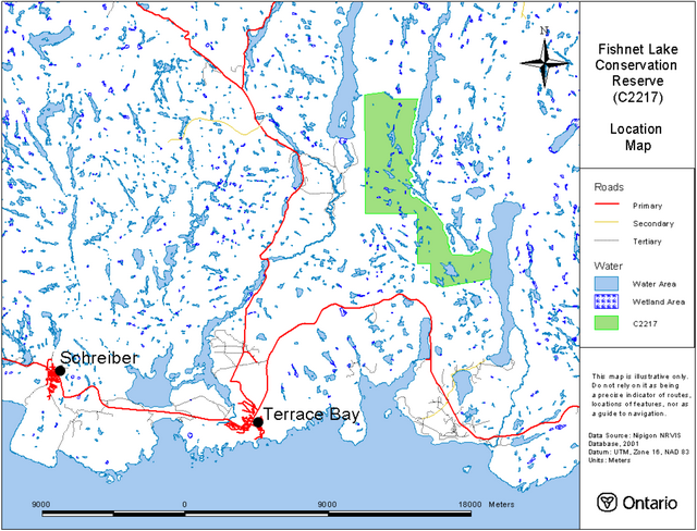
Enlarge Fishnet Lake Conservation Reserve (C2217) - Site location reference map
Appendix 2: Site and values map of the Fishnet Lake Conservation Reserve
Fishnet Lake Conservation Reserve (C2217) - Site and values map
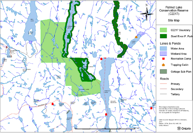
Enlarge Fishnet Lake Conservation Reserve (C2217) - Site and values map
Appendix 3: Permitted uses table
| Activity/Value | Permitted | Not Permitted | Modified | District Manager Approval |
|---|---|---|---|---|
| Sport Hunting | Yes | |||
| Commercial Trapping | Yes | |||
| Boating / Canoeing / Kayaking | Yes | |||
| Baitfishing | Yes | |||
| Commercial Wild Rice Harvest | N/A | |||
| Mineral Exploration & Extraction | Yes | |||
| Land Disposition for Private Purposes | Yes | |||
| All Terrain Vehicle | Yes | |||
| Snowmobile | Yes | |||
| Land Claims | Yes | |||
| Traditional Use | Yes | |||
| Native Hunt Camps | Yes | |||
| Commercial Tourism Based Hunting | Yes | |||
| Native Hunting | Yes | |||
| Commercial Native Trapping | Yes | |||
| Wildlife Management | Yes | |||
| Commercial Forest Operations | Yes | |||
| Vegetation Management (i.e. herbicides) | Yes | |||
| Timber Harvest for Personal Use | Yes | |||
| Fuelwood Harvest | Yes | |||
| Insect & Disease Suppression | Yes | |||
| Sport Fishing | Yes | |||
| Commercial Fishing | Yes | |||
| Native Fishing | Yes | |||
| Water Control Structures | Yes | |||
| Aggregate Extraction | Yes | |||
| Bear Management Areas | Yes | |||
| Trapline Cabins | Yes | |||
| Wild Rice Harvest | N/A | |||
| Boat Caches | Yes | |||
| Fire Management | Yes | |||
| Archeological Study | Yes | |||
| Backcountry Travel | Yes | |||
| Wildlife / Vegetation Viewing | Yes | |||
| Photography | Yes | |||
| Hiking | Yes | |||
| Rock Climbing | Yes | |||
| Mountain Biking | Yes | |||
| Nordic Skiing | Yes | |||
| Snowshoeing | Yes | |||
| Aircraft | Yes | |||
| Roads / Bridges / Culverts | Yes | |||
| Ongoing Research | Yes | |||
| New Research | Yes |
"Modified" – refers to a use which may be permitted under certain circumstances where the use would not impact the values for which the Conservation Reserve was created to protect (e.g. new trails, clearings/docks for aircraft access, etc.)
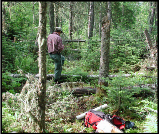
Figure 1: Fishnet Lake (foreground). Numerous smaller lakes are visible in the background of the photograph. Photograph by Allan Harris.
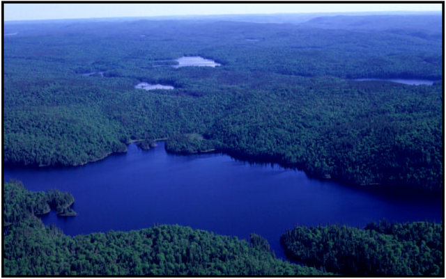
Figure 2: Terrain of the conservation reserve along the western shore of Santoy Lake. This is the landscape through which the portage winds. Photograph by Allan Harris.
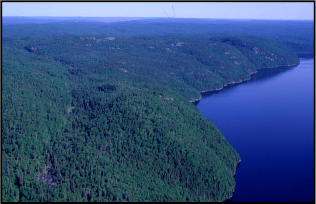
Figure 3: One of the many hills in the Fishnet Lake Conservation Reserve. Photograph by Allan Harris.
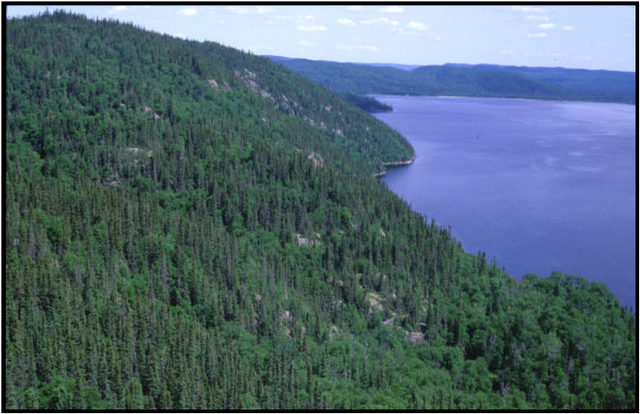
Figure 4: Aerial view of the conservation reserve’s topography. Photograph by Allan Harris.
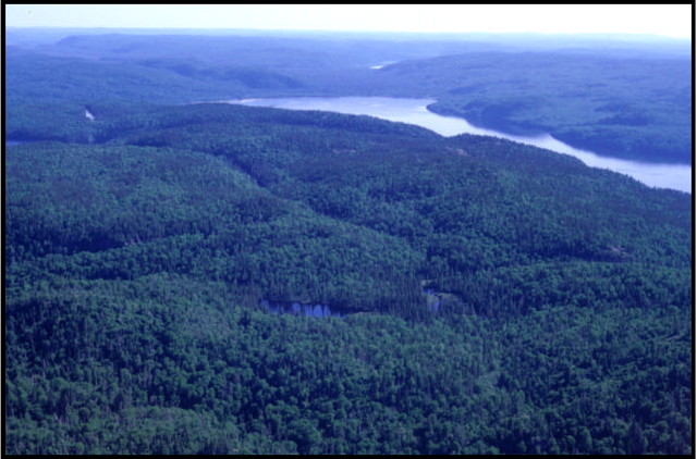
Figure 5: Rounded hill with bald bedrock crest. Probable evidence of wave-washing. Photograph by Allan Harris.
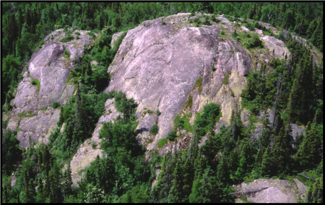
Figure 6: Exposed granitic bedrock. Photograph by Charles Faust.
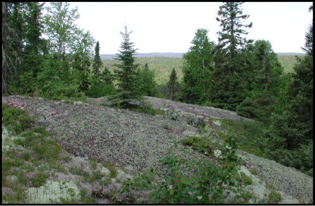
Figure 7: Blue-bead lily, Fishnet Lake Conservation Reserve. Photograph by Charles Faust.
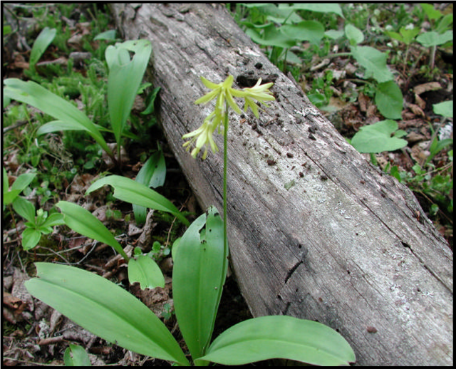
Figure 8: Representative understory vegetation of the conservation reserve. Photograph by Charles Faust.