Garson Forest Conservation Reserve Management Statement
This document provides policy direction for the protection, development and management of the Garson Forest Conservation Reserve and its resources.
Statement of Conservation Interest
Ontario Ministry of Natural Resources
Information and Resource Management, Sudbury District
November 2004
Ce document est seulement disponsible en anglais.
Ontario Ministry of Natural Resources
Sudbury District
Approval statement
I am pleased to approve this Statement of Conservation Interest (SCI) for Garson Forest Conservation Reserve (C177).
Garson Forest Conservation Reserve is dominated by exposed bedrock outcrops but also includes small wetland areas and supports young birch (Betula papyrifera) and poplar (Populus species) communities. Regulated on November 22, 2002, this 204-hectare conservation reserve is situated in Garson Township (now part of the City of Greater Sudbury) and is located approximately 15 kilometres northeast of the downtown core of the City of Greater Sudbury
Direction for establishing, planning and managing conservation reserves is defined under the Public Lands Act, the Crown Land Use Policy Atlas, the Ontario’s Living Legacy Land Use Strategy and other applicable policies. The specific direction for managing this conservation reserve is in the form of a basic SCI, which defines the area to which the plan applies, provides the purpose for which the conservation reserve has been proposed, and outlines the Ministry of Natural Resources' management intent for the protected area. This SCI has been created with input from program specialists within the Sudbury District. It will provide both the foundation for the continued monitoring of activities and guidance for the management of the conservation reserve. More detailed direction at this time is not anticipated. However, should significant facility development be considered or complex issues arise requiring additional studies, more detailed management direction in the form of special protection measures, or a detailed Resource Management Plan, will be prepared with full public consultation.
Public and Aboriginal consultation occurred prior to the regulation of this conservation reserve. Additional consultation periods took place in October and November 2004, which provided stakeholders the opportunity to comment on the draft SCI. Comments from the review period have been considered in the development of this document.
The management guidelines outlined in this SCI will be implemented by the Sudbury Area Supervisor, and will be reviewed every five years and amended as required by the District Planner, Sudbury District, and Ministry of Natural Resources.
Prepared by:
Rebecca Zeran, Mike Jackson
Crown Land and Protected Areas Planning Assistants
Date: November, 2004
Recommended for Approval by:
Ernie Heerschap for Stephen Devos
A/Sudbury Area Supervisor
Date: 18/01/2005
Cindy Blancher-Smith
District Manager, Sudbury District
Date: 31/01/2005
Approved by:
Rob Galloway
Regional Director, Northeast Region
Date: 09/02/2005
Executive summary
The purpose of this Statement of Conservation Interest is to identify and describe the natural, recreational, and cultural values of Garson Forest Conservation Reserve and to outline and guide the Ministry of Natural Resources' management intent for this area.
Garson Forest Conservation Reserve (C177) was regulated on November 22, 2002. The 204-hectare conservation reserve is situated in Garson Township (now part of the City of Greater Sudbury) and is located approximately 15 kilometres northeast of the downtown core of the city. The administrative details of the site are summarized in Table 1 below.
Garson Forest Conservation Reserve is dominated by exposed bedrock outcrops but also includes small wetland areas and supports young birch (Betula papyrifera) and poplar (Populus species) communities.
Table 1: Administrative details for Garson Forest Conservation Reserve (C177).
| OMNR Administrative Region/District/Area | Northeast Region/Sudbury District/Sudbury Area |
|---|---|
| Site Region – Site District (Hills 1959) | 5E-4 Sudbury |
| Ecoregion – Ecodistrict (Crins and Uhlig 2000) | 5E-4 |
| Township | Garson |
| Topographical Map Number & Name | 41 I/10 Capreol |
| UTM Co-ordinates | Zone 17 (NAD 83) 512159 E, 5162365 N |
| Latitude/Longitude | 46˚37'02"N / 80˚50'24"W |
| OBM Numbers | 2017510051600 |
| Nearest Town | Approximately 15 km northeast of the downtown core of the City of Greater Sudbury. Close to Towns of Skead, Garson, Hanmer and Capreol (all part of Greater Sudbury). |
| Altitude | 300-360 m |
| Area | 204 ha |
| Wildlife Management Unit | 41 |
| Forest Management Unit | Sudbury Forest |
| Watershed | Lake Huron basin 2DB |
| Regulated | November 22, 2002 |
| Ontario Gazette | December 7, 2002 |
| SCI Completed | January 30, 2005 |
1.0 Introduction
The following document is a Statement of Conservation Interest (SCI) for Garson Forest Conservation Reserve (C177). The purpose of this SCI is to identify and describe the natural, recreational, and cultural values of Garson Forest Conservation Reserve and to outline the Ministry of Natural Resources' management intent for this area. The first three sections of this document highlight the provincial context in which it was produced, state its goal and objectives, and summarize the planning process for conservation reserves. Sections 4.0 through 7.0 are specific to Garson Forest Conservation Reserve and provide background information and management direction for the site. Section 8.0 outlines the requirements for continued implementation and review of this document.
Management direction specified in this SCI will serve to protect the conservation reserve for the benefit of all Ontario residents. This direction will comply with the land use intent and guidelines stated in the Crown Land Use Policy Atlas (CLUPA) on the internet at http://crownlanduseatlas.mnr.gov.on.ca. The CLUPA is a consolidation of existing local land use policies for Crown lands within the Ontario Living Legacy Land Use Strategy (LUS) (1999) planning area, an area that covers 45 percent of the province and that extends from Lake Simcoe in the south to the Albany River in the north. Additionally, this conservation reserve will be managed under the Public Lands Act (R.S.O. 1990, c.P.43), and will comply with all legal requirements as specified under the Environmental Assessment Act (R.S.O. 1990, c.E.18).
The Garson Forest Conservation Reserve is dominated by exposed bedrock outcrops but also includes small wetland areas and supports young birch (Betula papyrifera) and poplar (Populus species) communities. The protection of these features is considered paramount and future management decisions that affect these values will require a thorough evaluation to ensure that the values remain protected.
The Ontario Ministry of Natural Resources, Sudbury District, Sudbury Area will be responsible for implementing the management policies and guidelines for Garson Forest Conservation Reserve. Their primary role will be to provide public information and compliance monitoring to ensure adherence to current policies and guidelines.
2.0 Goal and objectives of the SCI
2.1 Goal
The goal of this SCI is to provide the framework and the direction to guide management decisions affecting Garson Forest Conservation Reserve while protecting natural heritage values and permitting land use.
2.2 Objectives
The following objectives are identified as the means to achieve the above stated goal:
2.2.1 Short term objectives
- To describe the site’s current state of the resource in terms of its values and existing uses and activities.
- To outline the Ministry of Natural Resources' management intent for the protected area.
- To provide direction for the evaluation of proposed new uses or economic ventures through the application of the Test of Compatibility (Appendix D) and applicable Environmental Assessment Act (e.g., the Class Environmental Assessment (EA) for Provincial Parks and Conservation Reserves) legislation.
2.2.2 Long term objectives
- To maintain the conservation reserve in as natural state as possible.
- To identify research and/or monitoring strategies that may contribute to sound long-term management of the conservation reserve.
- To create public awareness of the values within this conservation reserve by providing information on the resources it contains and protects, and to support responsible stewardship through partnerships with local stakeholders.
3.0 Management planning
3.1 Provincial context
Ontario’s network of protected areas has been established to conserve representative areas of the province’s natural diversity (which includes species, habitats, landforms, and ecological systems). Protected natural heritage areas are a key component in the sustainable management of natural resources, ensuring that representative sites within the larger managed landscape are retained in as natural a state as possible.
On July 16, 1999, the Ontario’s Living Legacy Land Use Strategy (LUS) (OMNR 1999) was released to guide the planning and management of much of Ontario’s Crown lands. Extensive consultation was conducted during the development of the LUS. The objectives of the LUS were to complete Ontario’s system of parks and protected areas; recognize the land use needs of the resource-based tourism industry; provide forestry, mining and other resource industries with greater certainty around land and resource use; and, enhance hunting, angling and other Crown land recreational opportunities.
These areas are considered to have significant features and values or are representative of major landforms and vegetation types. As such, they require protection from incompatible activities in order for their values to endure over time. The Garson Forest Conservation Reserve was created during this expansion and now forms part of Ontario’s network of natural heritage areas. The site contains a representative landscape dominated by exposed bedrock outcrops, but also includes small wetland areas and supports young birch and poplar communities.
The Ontario Ministry of Natural Resources has established conservation reserves as a tool to protect natural heritage values on Crown lands, while permitting most traditional Crown land uses to continue. These uses include recreational activities, such as hunting and fishing. Lands designated as conservation reserves in the LUS (OMNR 1999) are removed from the Sustainable Forest License area and mining and surface rights are withdrawn from staking under the Mining Act (RSO 1990 Chapter M.14).
The CLUPA, available on the internet at http://crownlanduseatlas.mnr.gov.on.ca, is a consolidation of existing Crown land use policies and is now the official source for guidance on the management of Crown land and protected areas.
3.2 Planning for a conservation reserve
The planning process for a conservation reserve consists of regulating the site and preparing a site specific management plan. Consultation with the public, aboriginal communities and industry occur during site identification, boundary finalization, and management planning. Regulation of a conservation reserve involves the preparation of a legal description of site boundaries, the removal of the site from the Sustainable Forest Licence area, and the withdrawal of the site from staking under the Mining Act (RSO 1990 Chapter M.14). Once a conservation reserve is regulated, the level of management planning required to fulfill the protection targets is determined, and a basic Statement of Conservation Interest (SCI), enhanced SCI or a Resource Management Plan (RMP) is prepared.
A basic SCI is prepared when there is no deviation from the land use direction provided in the LUS (OMNR 1999) and there are few to no issues that require resolution. Alternatively, a RMP is prepared in situations where one or more complex issues have to be addressed, and/or where there is widespread public interest in a site. An enhanced SCI is an intermediary document which is used when a site requires more detailed management direction than would be provided by a basic SCI, but does not have issues significant enough to warrant the preparation of a RMP. Whichever the determination, the plan must be completed within three years of the conservation reserve’s regulation date. The guidelines for the preparation of these documents are provided in Procedural Guidelines A – Resource Management Planning (OMNR 1997) and the Northeastern Region Guidelines on the Planning Process for Conservation Reserves: Statement of Conservation Interest and Resource Management Plan (Thompson 2001).
A SCI is a management plan guided by the policy direction contained in the CLUPA (see Appendix C). The purpose of a SCI is to identify the state of the resource in terms of the site’s values and its current land use activities, and to outline the Ministry of Natural Resources' management intent for the conservation reserve. Basic SCI's typically have a 30-day public consultation period, whereas enhanced SCI's and RMP's have a longer consultation period. Upon completion of this public review, the SCI or RMP is revised as necessary and approved by the Regional Director, MNR Northeast Region.
Existing permitted uses within conservation reserves may continue, unless they are shown to have a significant negative impact on the values protected by the site. A review/evaluation mechanism is in place to address new permitted uses or land use proposals. The Test of Compatibility (Appendix D), as outlined in the Conservation Reserves Policy PL 3.03.05 (OMNR 1997a) and Environmental Assessment Act legislation will be used to screen proposals. Once approved, the Class Environmental Assessment for Provincial Parks and Conservation Reserves (OMNR 2003) will be used to screen most project proposals and management activities occurring within the conservation reserve.
Where cultural resources may be impacted, proposals may be screened through Conserving a Future for our Past: Archaeology, Land Use Planning & Development in Ontario, Section 3 (MCzCR 1997).
Public comment may be solicited during a review of any future land use proposals that require new decisions to be made. Appropriate Environmental Assessment Act (R.S.O. 1990, c.E.18) requirements and amendment processes (e.g., Environmental Bill of Rights posting, CLUPA amendment) will apply to any future proposal and/or any significant change in management direction being considered for a site.
3.3 Planning process for Garson Forest Conservation Reserve
3.3.1 Boundary refinement and regulation
The Garson Forest Conservation Reserve was proposed as a conservation reserve in the LUS (OMNR 1999). A letter, fact sheet and proposed boundary map were mailed to stakeholders and to interested members of the public during the boundary consultation process. Consultation occurred with the general public, aboriginal communities, and industry, and the boundary of the site was regulated through an amendment to Ontario Regulation 805/94 of the Public Lands Act on November 22, 2002, by Ontario Regulation 313/02. The official Ontario Gazette amendment is available on the internet at http://www.ontariogazette.gov.on.ca/ in volume 135, issue 49 on December 7, 2002.
3.3.2 Planning area
The planning area for this SCI consists of the regulated boundary for Garson Forest Conservation Reserve (see Figure 1). However, to fully protect values within the conservation reserve, the area beyond the regulated boundary may require additional consideration through landowner outreach programs when adjacent land uses pose potential negative impacts on the conservation reserve. Crown land areas beyond the regulated boundary may also require additional consideration when larger land use planning initiatives, such as forest management planning, pose potential negative impacts on the site. Section 5.7- Ecological Considerations and section 7.1- Additions to the Reserve discuss management implications with areas outside the regulated boundary.
3.3.3 Consultation and significant land use issues
To date, no significant issues related to land use in this area have been identified. For this reason, it was determined that a basic SCI will adequately identify the site’s significant features and serve as the appropriate format for providing management direction. It should be noted that this document addresses only those issues or land use proposals currently known to the Ministry of Natural Resources, Sudbury District. The direction provided by this SCI, and future management decisions, will work to resolve any potential land use conflicts and ensure that identified values continue to be adequately protected.
This SCI has been created with input from program specialists at the area, district, regional and provincial levels of the Ministry of Natural Resources. Public, aboriginal communities and industry were also provided an opportunity to comment on a draft of this SCI. A public consultation period took place October 13th, 2004 to November 13th, 2004. Notification of this review period occurred via an information package mailed to affected stakeholders and an advertisement that appeared in local newspapers. Comments received during this period were considered in the refinement of this document. Upon approval of this SCI, public notification will occur via mail-out to interested stakeholders and a notice will appear in local newspapers.
4.0 Background information
4.1 Location and site description
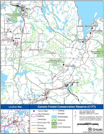
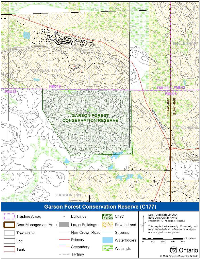
Garson Forest Conservation Reserve is located within the municipality of the City of Greater Sudbury and is approximately 2 kilometres west of the Sudbury airport and 7 kilometres southwest of Lake Wahnapitae. The 204-hectare conservation reserve is situated approximately 7.5 kilometres west of the MacLennan Esker Forest Conservation Reserve (C178) and about 17 kilometres southwest of Chiniguchi Provincial Park (P174). Figure 1 illustrates the general location of the Garson Forest Conservation Reserve.
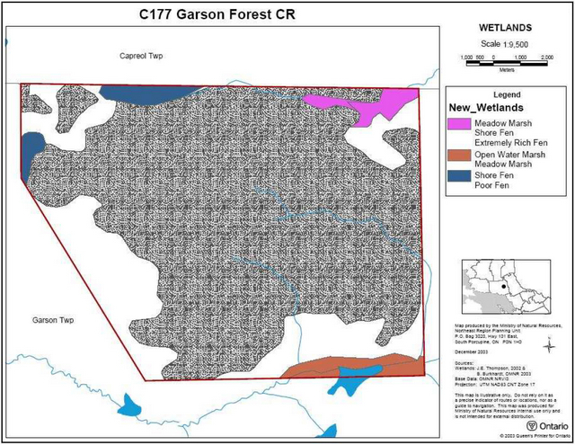
Figure 1: Site location map for Garson Forest Conservation Reserve.
Enlarge Figure 1: Site location map for Carson Forest Conservation Reserve
Whenever possible, recognizable natural and cultural features, such as creeks, shorelines or old roads have been used to delineate conservation reserve boundaries to facilitate on-the-ground identification. Patent land lies adjacent to the northern and eastern sides of the conservation reserve. All conservation reserve boundaries are vectored and do not follow natural features.
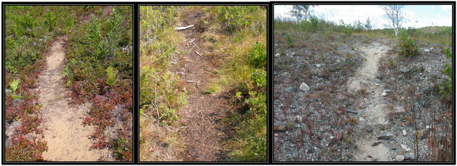
The Garson Forest Conservation Reserve can be accessed via a well-worn foot path (figure 2) leading into the northeast corner of the site from Regional Road 85 (Radar Road).
Garson Forest Conservation Reserve is located within Sudbury Ecodistrict1 5E-4 (Hills 1959), an ecological unit which incorporates most of the area comprising the City of Greater Sudbury. The conservation reserve is dominated by exposed bedrock outcrops but also includes small wetland areas and supports young birch and poplar communities. Section 5.2 (Natural Heritage Values) further discusses the life science and earth science values of the conservation reserve and Section 5.3 (Quality of the Resource) discusses the current state of these values.
Figure 2: Three photographs of sections of the walking trail leading into the conservation reserve from Regional Road 85.
4.2 Site history
Much of the area surrounding Sudbury (including the area within which the Garson Forest Conservation Reserve is located) has been influenced by logging and mining operations, which began to occur with railroad construction in the 1880s and mining and logging in the early
1900s. Smelting emissions changed the chemical composition of soil and water, causing vegetation to die and exposing massive tracts of land to erosion. To mitigate these impacts, local mining companies applied lime and fertilizers to damaged areas in the late 1970s and early 1980s. Grass, legume and trees were also planted during this reclamation process (Cudmore et. al. 2004).
4.3 Socio-economic interest
The Garson Forest Conservation Reserve is located within the municipality of the City of Greater Sudbury and the site is fairly accessible (see Section 4.1). The site is potentially important to local residents (especially within the nearby Towns of Skead, Garson, Hanmer and Capreol) for both recreational purposes. The conservation reserve provides excellent access to productive blueberry patches. During ground visits to the site, people were observed picking blueberries within the boundaries of the conservation reserve. The site has reportedly been accessed for blueberry-picking activities for over two decades. An active Bear Management Area and trapline encompass the site. Although it is not known if the conservation reserve is used for such activities, hunting and trapping are long-standing traditional activities in the area and are a vital part of the local economy. Protecting this parcel of land as a conservation reserve will ensure that hunting and trapping be able to continue in this area into the future.
The designation of this area as a conservation reserve allows for the permanent protection of the province’s natural heritage values. This site contains bedrock outcrops with young birch and poplar communities. The area is actively undergoing a reclamation process due the loss of vegetation following smelting and logging operations prior to 1970 (Cudmore et. al. 2001). Protecting this site may allow for the long-term monitoring and study of the effectiveness and progress of this reclamation process, a process that is occurring throughout the municipality of the City of Greater Sudbury.
The conservation reserve lies within the Robinson-Huron Treaty Area #9. Protection of this area ensures that activities traditionally carried out by First Nation communities in this Treaty Area will be able to continue. The protection of this area as a conservation reserve and this Statement of Conservation Interest are not meant to infringe on Treaty and Aboriginal Rights.
4.4 Inventories
Table 2 indicates the current status of natural heritage inventories that have occurred for Garson Forest Conservation Reserve. Recommendations for future inventory needs are located in Table 3, subsection 7.2- Future Needs and Considerations.
Table 2: Inventory and survey information for Garson Forest Conservation Reserve.
| Type of Inventory | Inventory Method | Date(s) of Inventory | Report |
|---|---|---|---|
| Life Science | Aerial reconnaissance | 27 Aug. 2003 | Cudmore W., King L. and Longyear S. 2004. Garson Forest Conservation Reserve (C177) Natural Heritage Area - Life Science Checksheet. Unpublished Information. Ontario Ministry of Natural Resources. |
| Earth Science | Aerial photo interpretation | 2004 | Kristjansson, R.J. Earth Science Inventory Checklist for C177 Garson Forest Conservation Reserve. Unpublished Information. Ontario Ministry of Natural Resources. (In prep.) |
| Recreation | Ground and aerial reconnaissance | Ground: 29 July 2004 and 5 Aug. 2004. Air: 27 Aug. 2003 | Zeran, R. Garson Forest Conservation Reserve (C177) Recreation Resource Inventory Report. Unpublished Information. Ontario Ministry of Natural Resources. |
5.0 State of the resource
Descriptions in this section are not necessarily complete. If new values key or otherwise are identified, they will be added to this document as an amendment. If any new value is considered significant, management guidelines may be modified, if required, to ensure its protection.
5.1 Key values
Key values are values that make this site unique and have led to its designation as a conservation reserve. Their protection is paramount. The key values of the Garson Forest Conservation Reserve include the following:
- Representative landform for Sudbury District of exposed bedrock outcrops supporting young birch and poplar communities.
- Minor areas of glaciolacustrine sand and organic deposits (wetlands) associated with sand.
- Traditional recreational opportunities such as blueberry picking.
Additional values, listed in subsection 5.2- Natural Heritage Values, are also important features and activities identified within the site.
5.2 Natural heritage values
5.2.1 Earth science values
5.2.1a Regional landforms
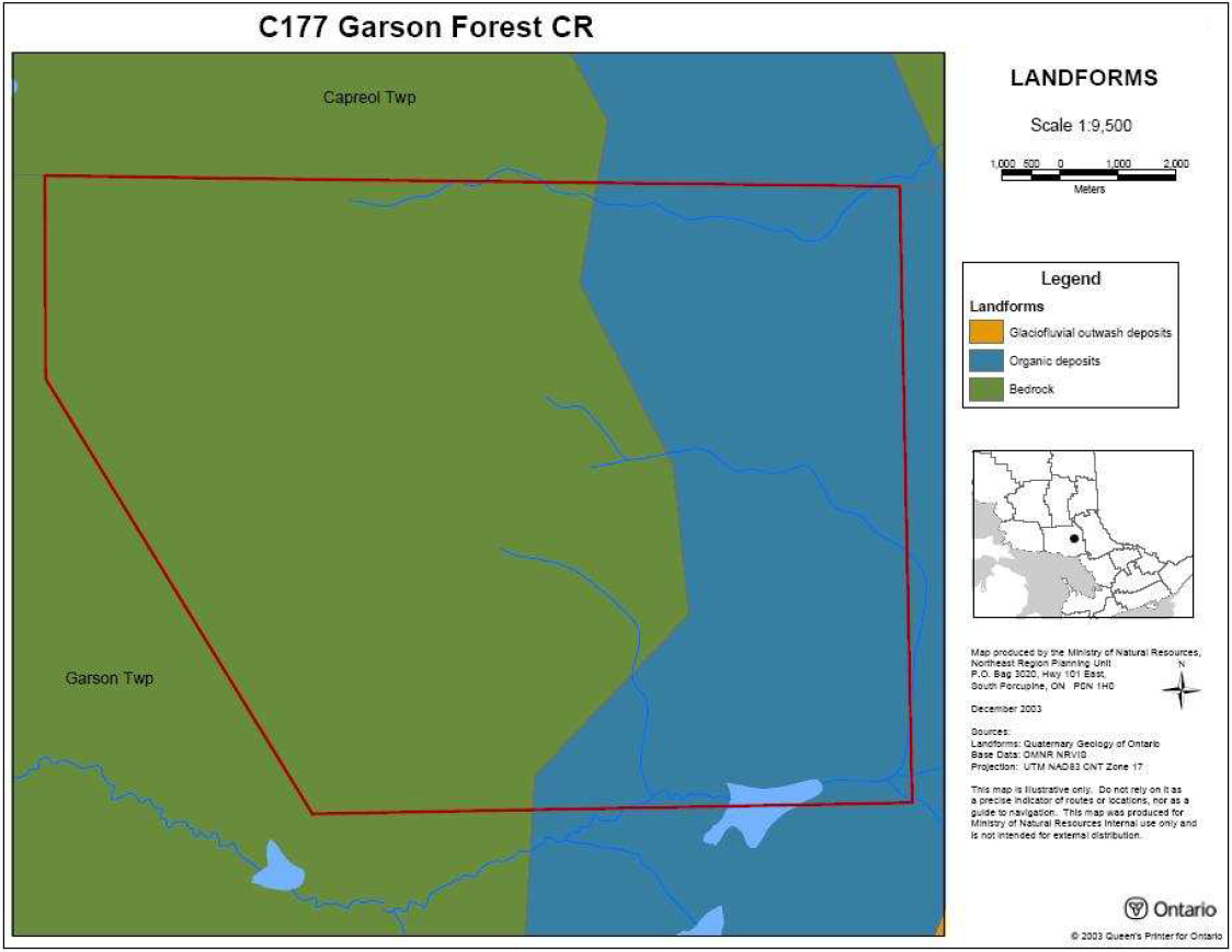
Garson Forest Conservation Reserve is found within Sudbury Ecodistrict 5E-4 (Hills 1959; Crins & Uhlig 2000) of Ecoregion 5E (Georgian Bay). The ecodistrict is characterized mainly by bedrock outcrops shallowly covered by stony sand and stone-free silt. Pockets of water-laid silt/sand and sand/gravel plains are also present in this ecodistrict. Sand content varies from granitic to trace amounts of lime and the bedrock relief includes weakly, moderately and strongly broken relief (Cudmore et. al. 2004). The ecoregion contains both lowland areas of water-laid materials broken by bedrock outcrops and upland areas of bedrock overlain with material of varying depth. Soil types in this region consist of brown podsolic and weakly developed podsols on sandy soils in the upland areas and limy clays and silts in the lowland areas (Cudmore et. al. 2004).
5.2.1b Surficial geology
The Garson Forest Conservation Reserve is dominated by exposed bedrock outcrops (Kristjansson, pers. comm.). Minor areas of discontinuous glaciolacustrine sand (Unit 6a) and small areas of organic deposits associated with sand are located in the southeast, northeast and northwest corners of the site (Kristjansson pers. comm.).
5.2.1c Bedrock geology
The Garson Forest Conservation Reserve is underlain by undifferentiated sedimentary rocks of the Huronian Supergroup, Southern Province, Precambrian Shield (Kristjansson pers. comm.).
5.2.2 Life Science values
5.2.2a Regional ecology
The conservation reserve is found in ecoregion 5E (Georgian Bay) (Hills 1959; Crins & Uhlig 2000). Vegetation in this region typically consists of sugar maple (Acer saccharum), yellow birch (Betula alleghaniensis), eastern hemlock (Tsuga canadensis), and white pine (Pinus strobus) on fresh sites; white spruce (Picea glauca) and balsam fir (Abies balsamea) on fresh clays and cooler valleys mixed with hardwoods at higher altitudes; and black spruce (Picea mariana) and tamarack (Larix laricina) in cold wet areas. Forest climate for this area is mid- humid, warm-boreal. The area is also located in section L.4e (Sudbury-North Bay) of Rowe’s (1972) Great Lakes – St. Lawrence Forest Region. Extensive disturbance (i.e., forest cutting, forest fires and nickel smelting fumes) has occurred in section L.4e, resulting in the destruction and/or reduction of many naturally occurring species (Cudmore et. al. 2004). Presently, pioneer species such as trembling aspen and white birch occur, with only scattered occurrences of regional characteristic species such as jack pine (Pinus banksiana), sugar maple, yellow birch, red pine (Pinus resinosa), white pine, balsam fir and black spruce (Cudmore et. al. 2004).
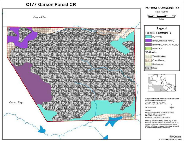
5.2.2b Vegetation and forest communities
There are three different forest communities represented within the Garson Forest Conservation Reserve: pure poplar (9.8% of total area), white birch predominant hardwood (7.4%), and white birch dominant hardwood (2.9%). Bedrock (at times with scattered poplar and birch) dominates the conservation reserve, covering 73.5% of the site’s total area (Cudmore et. al. 2004). The forest communities appear to be even-aged with trees ranging from 30 to 60 years of age (Cudmore et. al. 2004). The pure poplar stands have a 0% stocking distribution, while the white birch predominant hardwood stands are stocked at both 1-40% and 41-60% (Cudmore et. al. 2004).
Ground vegetation on the bedrock-dominated portions consists mainly of white birch shrubs, blueberries (Vaccinium species), and a variety of lichen, moss, grass and sedge. Ferns, ground cedar (Lycopodium digitatum) and sweet fern (Comptonia peregrina) are also present within the conservation reserve. Laurel (Kalmia species) grows abundantly in areas of the site underlain by organic deposits (e.g., in the northeast corner).
5.2.2c Fish and wildlife
No fisheries values have been identified in the creeks that run through the conservation reserve. The small wetland areas within the site (see section 5.2.2d) may provide habitat and food resources for several of avian species.
Local recreational users of the site report that black bear (Ursus americanus), white-tailed deer (Odcoileus virginianus) and great blue herons (Ardea herodias) have been observed within the conservation reserve. The scattered nature of the forest cover in the conservation reserve probably limits its use as habitat for many wildlife species; however, the area could potentially be used as a corridor for furbearer movement.
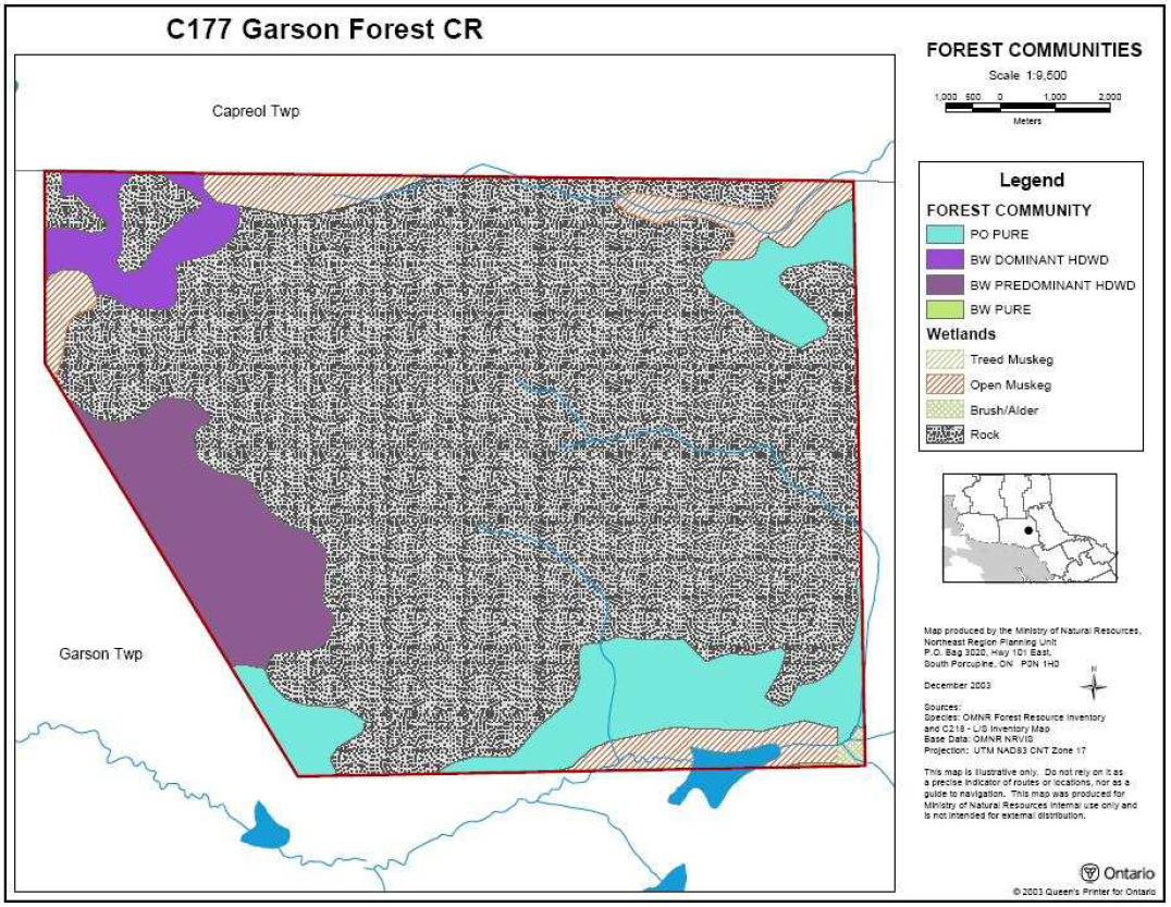
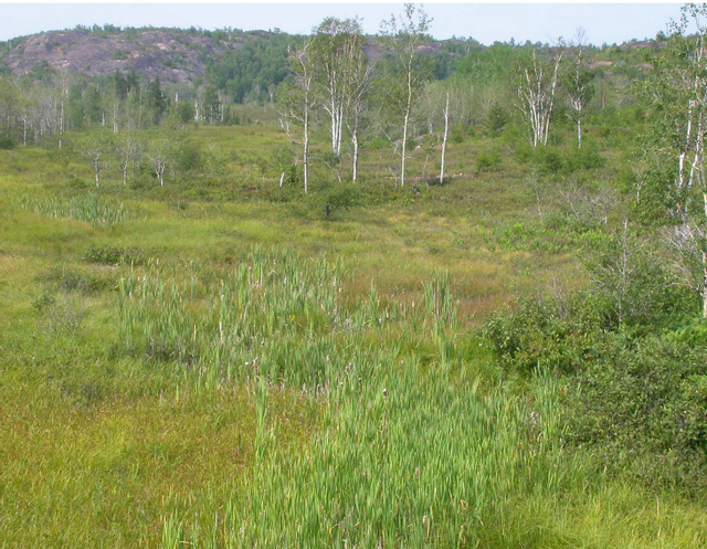
5.2.2d Wetlands and watersheds
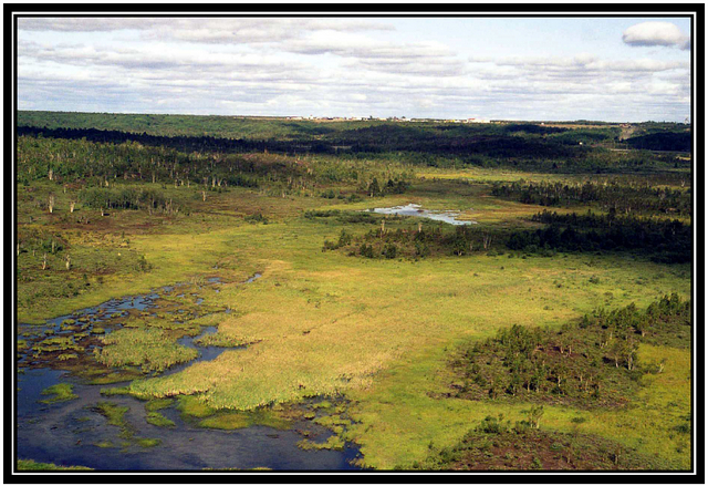
The conservation reserve encompasses several small wetlands: a shore fen/poor fen in the northwest, a meadow marsh/shore fen/extremely rich fen in the northeast, and an open water marsh/meadow marsh in the south (figure 3) (Cudmore et. al. 2004). There are a few creeks within the conservation reserve which probably serve as headwater sources, eventually feeding into Garson Lake (Cudmore et. al. 2004). A small community of brush/alder is located in the southeast corner of the site and makes up only 0.2% of the total area of the conservation reserve (Cudmore et. al. 2004). Bedrock gullies support shallow meadow marsh wetlands with low shrubs or graminoid ferns (Cudmore et. al. 2004).
The conservation reserve is located in the tertiary watershed 2DB of the Lake Huron major basin.
Figure 3: Aerial view of the wetland along the southern border of the conservation reserve. Photo by B. Burkhardt, 27 August 2003.
5.2.2e Species at risk
No Species at Risk have been identified or documented within the conservation reserve.
5.2.3 Recreational values
The conservation reserve is located close to populated areas in the City of Greater Sudbury and is can be easily accessed from Regional Road 85 (Radar Road). The site is encompassed by one bear management area, one trapline and one baitfish block. Recreational activities occurring within the conservation reserve include: blueberry picking, hiking, hunting and landscape viewing (Zeran 2004). The extent to which trapping and baitfish harvesting occur within the conservation reserve in unknown.
5.2.4 Cultural values
The conservation reserve is located within the Robinson/Huron Treaty Area #9. Several First Nations have identified numerous recreational and cultural activities that occur throughout this Treaty area, including areas designated as conservation reserves (such as the Garson Forest).
The area contained within the conservation reserve has been historically used for hunting and trapping. Intensive forest harvest activities have occurred throughout the area during the mid nineteenth century. See section 4.2 – Site History for a more detailed discussion on historical occurrences within the conservation reserve.
5.2.5 Research values
No known research activities have occurred within the boundary of Garson Forest Conservation Reserve.
5.3 Quality of the resource
5.3.1 Site condition
The level of disturbance2 in the conservation reserve is considered high (Cudmore et. al. 2004). Since the early nineteenth century, the entire area has been impacted by human operations (i.e., logging, prospecting and smelting emissions). The smelting emissions in particular have drastically altered environmental conditions, causing soil and water to become too acidic for many species of vegetation (Cudmore et. al. 2004). Unable to survive in the new habitat conditions, most vegetation died, leaving the land exposed to soil erosion and a further loss of nutrients. In the early 1970s, lime and fertilizers were applied to the areas and grass, legume and trees were planted in an attempt to mitigate the negative effects that industry has had on the area (Cudmore et. al. 2004). Natural disturbance is limited to the beaver activity that has occurred in the wetland located at the south end of the conservation reserve (Cudmore et. al. 2004).
5.3.2 Diversity
Diversity3 is a measure of the site’s life and earth science heterogeneity. The diversity of the site has been initially rated as low (Cudmore et. al. 2004). There are only five landform: vegetation combinations (bedrock: BW1, bedrock:PO, organic deposits:PO, bedrock: open muskeg, organic deposits: open muskeg) (Cudmore et. al. 2004). This rating will need to be revisited in the future since at this time differing map projections may have resulted in minor misinterpretation of vegetation and landform layers.
5.3.3 Ecological considerations
The area protected by the conservation reserve is very small and the site falls far short of the2000 ha minimum size standard that Ontario Parks has established for protecting representative natural areas (Cudmore et. al. 2004). All boundaries of the conservation reserve are vectored and do not follow natural features such as streams. Patent land surrounds the northern and eastern sides of the conservation reserve and Crown land lies adjacent to the western and southern sides. All wetlands included into the conservation reserve are severed by vectors (Cudmore et. al. 2004). The boundaries of the conservation reserve could be extended towards the south and west in order to better incorporate biological boundaries and protect the entire wetland area (Cudmore et. al. 2004).
As discussed in Section 5.3.1, the entire area protected by the conservation reserve has been impacted by human operations (i.e., logging, prospecting and smelting emissions).
The area is easily accessible at the northern end of the conservation reserve for the purposes of low impact recreational use (i.e., hiking, snowshoeing). Low impact recreational use is not expected to greatly impact the natural features of the conservation reserve. However, patent land lies adjacent to the conservation reserve, providing landowners with access to the conservation reserve by motorized means (snowmobiles, ATVs). Such uses could potentially have a negative impact on the values protected by the conservation reserve if they destroy or impede the growth of young trees (currently undergoing a reclamation process). Use of ATVs in the areas of organic and glaciolacustrine sand deposits could potentially harm these features.
6.0 Management guidelines
All management guidelines in this SCI are based on the policy direction contained in the Crown Land Use Policy Atlas (CLUPA). For the most up-to-date version of this policy report, please refer to the CLUPA on the internet at http://crownlanduseatlas.mnr.gov.on.ca, or contact your local Ministry of Natural Resources office. A summary table of the management guidelines, outlining permitted uses within the site, is located in Appendix C.
The management guidelines outlined in this section are specific to the Garson Forest Conservation Reserve and are intended to protect the site’s unique values. The guidelines in this document are subject to change and may be amended as necessary. If a conflict between management guidelines exists, the conservation reserve will be managed to protect the integrity of its natural values, while permitting compatible land use activities (OMNR 1997).
Proposed new uses and/or development, including research and education activities, will be reviewed on a case-by-case basis. All new proposals will be subject to evaluation under at least one of the following processes: the Test of Compatibility (Appendix D); the Environmental Assessment Act (R.S.O. 1990, c.E.18); and Conserving a Future for our Past: Archaeology, Land Use Planning & Development in Ontario, Section 3 (MCzCR 1997). Once approved, the Class Environmental Assessment for Provincial Parks and Conservation Reserves (OMNR 2003a) will be used to screen most proposals and management activities occurring within the conservation reserve.
6.1 First Nations
Traditional activities and Aboriginal rights, as defined in the Robinson-Huron Treaty #9 and other applicable legislation, will not be affected by the boundaries of this conservation reserve.
Any First Nation land claims within this area will be addressed according to appropriate Ministry of Natural Resources' procedures. When possible, the Ministry of Natural Resources will work with the Ontario Ministry of Culture to identify archaeological and/or cultural sites to be protected.
6.2 Industrial activities
6.2.1 Commercial timber harvest
The area contained within this conservation reserve (204 ha) has been withdrawn from the Sudbury Forest Sustainable Forest License area and no commercial timber harvesting will be permitted. Please refer to subsection 6.5.3- Non-Commercial Consumptive Resource Use for information regarding non-commercial wood harvesting.
6.2.2 Mining and exploration
There are no existing mining claims or leases within the area regulated as the Garson Forest Conservation Reserve. Mining and surface rights within the conservation reserve’s boundaries have been withdrawn from staking under the Mining Act (RSO 1990 c.M.14). Mineral exploration is not permitted.
6.2.3 Extraction of peat, soil, aggregate and other material
No extraction operations currently occur within the conservation reserve. No new activities for the extraction of peat, soil, aggregate or other material will be permitted within the conservation reserve.
6.2.4 Energy generation
No energy generation facilities exist within the conservation reserve. New hydropower development and windpower generation operations are not permitted.
6.3 Existing and Proposed Development
6.3.1 Transportation corridors
6.3.1a Roads
Under the Public Lands Act, section 48 (OMNR 2003a), a road is defined as "a travel corridor that is reasonably capable of allowing travel by motor vehicles licensed to operate on a King’s Highway as defined in the Highway Traffic Act (e.g., personal or commercial cars and trucks)."
Minor maintenance (as defined under Policy PL 3.03.04 [OMNR 2003b]) of existing roads will be permitted provided that maintenance activities do not negatively impact the values being protected by the conservation reserve. Road maintenance activities may be subject to a Test of Compatibility (Appendix D) thru the Environmental Assessment Act.
No private roads exist within site. New access roads proposed after March 29, 1999 and, for which MNR did not make a commitment, will not be permitted within the conservation reserve.
According to the LUS (OMNR 1999), new roads for resource extraction will not be permitted except for those identified in Forest Management Plans prior to March 31, 1999. No new or existing roads for resource extraction were identified within the conservation reserve prior to this date.
6.3.1b Trails
Under Ontario Regulation 453/96 (OMNR 2003a), a trail is defined as "a path over public lands not used for mineral exploration or extraction." A trail is minor in nature compared to a road, allowing passage of pedestrians, ATVs, snowmobiles or the like (OMNR 2003b).
A footpath (suitable only for walking) leading into the northeastern corner of the site has been documented. No other recreational trail is known to exist within the conservation reserve.
Minor maintenance (as defined under Policy PL 3.03.04 [OMNR 2003b]) of existing trails will be permitted provided that maintenance activities do not negatively impact the values being protected by the conservation reserve. Trail maintenance may be subject to a Test of Compatibility (Appendix D) thru the Environmental Assessment Act.
Any proposed new trails or development of existing trails are subject to the Test of Compatibility (Appendix D) and applicable Ministry of Natural Resources' policies and procedures. Trail development should take into account the unique characteristics of this site and must be compatible with the site’s key values. All existing and new trail heads and trail routes must be recorded using new technologies (i.e. global positioning systems) to ensure an accurate record of the location of the feature. This location information must be provided to the Ministry of Natural Resources, Sudbury District.
6.3.2 Other corridor development/maintenance
No communications or energy transmission corridors are present within the conservation reserve. New corridor developments will be actively discouraged. Proposals for new corridors will be subject to screening under the Environmental Assessment Act (e.g., the Class Environmental Assessment (EA) for Provincial Parks and Conservation Reserves).
6.3.3 Natural heritage appreciation facilities/recreational structures
There are currently no existing authorized natural heritage appreciation facilities or recreational structures (i.e. boardwalks, bird viewing platforms, kiosks, ski shelters, or interpretative signs) located within the conservation reserve. New public natural heritage appreciation facilities and recreation structures are permitted, subject to the Test of Compatibility (Appendix D) and to screening under the Environmental Assessment Act (e.g., the Class Environmental Assessment (EA) for Provincial Parks and Conservation Reserves).
Facility development should take into account the unique characteristics of this site and must be compatible with the site’s key values
6.3.4 Land disposition
Sale of land is not permitted, except for some types of minor dispositions (e.g., the sale of small parcels of land to provide adequate area for the installation of a septic system), where it does not detrimentally affect the key values of the site. Such sales will be screened under the Test of Compatibility (Appendix D) or the Environmental Assessment Act (e.g., the Class Environmental Assessment (EA) for Provincial Parks and Conservation Reserves). Boundaries of the conservation reserve would need to be amended through a de-regulation process to reflect the sale of land.
Existing leases or LUP's may be renewed or transferred subject to MNR approval. Private recreation camps may be eligible for enhanced tenure but may not be sold. Permit holders for outpost camps or tourism facilities (e.g., main base lodges) can apply to upgrade tenure from a LUP to a lease.
No Land Use Permits (LUP's) are currently issued within this conservation reserve. New leases or LUP's may be issued for approved public uses (i.e. not for private recreation camps), subject to the Test of Compatibility (Appendix D) and applicable Ministry of Natural Resources' policies and procedures.
6.4 Commercial activities
6.4.1 Commercial bait harvesting
One commercial baitfish harvest block (SUD0038) is associated with the conservation reserve. New operations may be considered subject to the Test of Compatibility (Appendix D) and to screening under the Environmental Assessment Act (e.g., the Class Environmental Assessment (EA) for Provincial Parks and Conservation Reserves).
Any proposed new trails for baitfish harvesting purposes are subject to the Test of Compatibility (Appendix D) and to screening under the Environmental Assessment Act (e.g., the Class Environmental Assessment (EA) for Provincial Parks and Conservation Reserves). Please refer to subsection 6.3.1 – Trails for further information on the establishment and maintenance of new trails and subsection 6.5.5 – ATV and Snowmobile Use for further information on their usage.
6.4.2 Commercial fishing
There are currently no commercial fisheries operating within the conservation reserve. New operations may be considered subject to the Test of Compatibility (Appendix D) and to screening under the Environmental Assessment Act (e.g., the Class Environmental Assessment (EA) for Provincial Parks and Conservation Reserves). Please refer to subsection 6.5.5 – ATV and Snowmobile Use for further information on their usage
6.4.3 Commercial fur trapping
Registered Trapline SU15-0710-01 encompasses the boundary of this conservation reserve. This registered trapline area is currently allocated to a head trapper. If a head trapper surrenders a registered trapline, or the head trapper’s privileges are revoked, the registered trapline may be transferred to another trapper following established allocation procedures. If the registered trapline is not transferred in due course, or remains unallocated for a significant period of time, reallocation of the trapline may occur following applicable district screening processes.
Any proposed new trails for the purposes of commercial fur trapping are subject to the Test of Compatibility (Appendix D) and to screening under the Environmental Assessment Act (e.g., the Class Environmental Assessment (EA) for Provincial Parks and Conservation Reserves). Please refer to subsection 6.3.1 – Trails for further information on the establishment and maintenance of new trails and subsection 6.5.5 – ATV and Snowmobile Use for further information on their usage.
No licensed trap cabins currently exist within Garson Forest Conservation Reserve. The establishment of new trap cabins will not be permitted.
6.4.4 Bear Management Areas
One Bear Management Area (BMA), SU-41-032, is associated with this conservation reserve.
The policies regarding BMA's (OMNR 2003a) states that the issuance of Licences to Provide Bear Hunting Services will be allowed where areas have been licensed or authorized under agreement for the activity since January 1, 1992.
Any proposed new trails for the purposes of bear hunting are subject to the Test of Compatibility (Appendix D) and to screening under the Environmental Assessment Act (e.g., the Class Environmental Assessment (EA) for Provincial Parks and Conservation Reserves). Please refer to subsection 6.3.1 – Trails for further information on the establishment and maintenance of new trails and subsection 6.5.5 – ATV and Snowmobile Use for further information on their usage.
6.4.5 Commercial food collection
There is currently no existing commercial food harvesting venture within the conservation reserve. Any new ventures requiring permits from the Ministry of Natural Resources will be subject to the Test of Compatibility (Appendix D) and to screening under the Environmental Assessment Act (e.g., the Class Environmental Assessment (EA) for Provincial Parks and Conservation Reserves).
6.4.6 Commercial non-timber forest products
Currently, there is no explicit policy direction towards the commercial harvesting of non-timber forest products. New ventures may be considered subject to the Test of Compatibility (Appendix D) and to screening under the Environmental Assessment Act (e.g., the Class Environmental Assessment (EA) for Provincial Parks and Conservation Reserves). Such ventures should be discouraged within the conservation reserve wherever possible, as they do not necessarily coincide with the intent of protecting the area as a conservation reserve.
6.4.7 Outpost camps/main base lodges
There are currently no existing authorized outpost camps or main base lodges within the conservation reserve. New outpost camps and main base lodges may be considered through planning and will be subject to the Test of Compatibility (Appendix D) and to screening under the Environmental Assessment Act (e.g., the Class Environmental Assessment (EA) for Provincial Parks and Conservation Reserves). The form of land tenure for these new uses will remain as a land use permit or lease. Sale of Crown land for new outpost camps or mainbase lodges will not be permitted.
6.5 Non-commercial activities
6.5.1 Nature appreciation/low-impact recreation activities
Off-trail hiking, cross-country skiing, snow-shoeing, and other non-motorized activities will be permitted within this conservation reserve. However, should the impact of these activities degrade the landscape, the Ministry of Natural Resources will re-evaluate these permitted uses and decide upon a new strategy for this site. New trails to support these activities may be considered. Please refer to subsection 6.3.1b- Trails for more details related to trail development.
6.5.2 Camping
There are no maintained campsites or campgrounds within this conservation reserve. Crown land camping policies apply, unless significant adverse effects on protected values necessitate further planning and management for this activity. Existing traditional campsites should be used in order to avoid disturbance of new areas within the conservation reserve.
6.5.3 Non-commercial consumptive resource use
Cutting of trees for non-commercial purposes may be authorized by the local Ministry of Natural Resources, subject to review and determination of the impact that such cutting would have on the values identified in section 5.0- State of the Resource. Such permits are intended only for leaseholders, Land Use Permit holders, cottagers and other property owners within the conservation reserve who do not have road access to their property and who do not have an alternate wood source outside of the conservation reserve. Property owners adjacent to the conservation reserve will not be issued permits for areas within the protected area. Such permits are intended to cover fuelwood, dock stringers, and other occasional small scale uses.
No stakeholders eligible for non-commercial consumptive resource use permits currently exist within the Garson Forest Conservation Reserve.
Non-commercial harvesting of non-timber forest products such as berries and mushrooms can occur provided the values of the site, identified in section 5.0- State of the Resource, are not jeopardized.
6.5.4 Hunting and fishing
In conjunction with current hunting regulations (Wildlife Management Unit 41), hunting is permitted to continue within the conservation reserve.
Recreational fishing is also permitted to continue in compliance with current fishing regulations.
Please see subsection 6.5.5- ATV and Snowmobile Use on the direct retrieval of large game and to subsection 6.3.1b (Trails) for information on the construction of new trails or the maintenance of existing trails.
6.5.5 ATV and snowmobile use
No existing recreational trail designated for either ATV or snowmobile use has been identified within the conservation reserve. Please refer to subsection 6.3.1b- Trails for more information on trails. In general, off-trail use of ATVs and snowmobiles is not permitted; however, in some cases, off-trail use is permitted for licensed trappers to access their traplines, for licensed bait harvest operators to conduct bait harvest operations and for use in bear management areas (BMA's). Hunters are also allowed off-trail ATV and snowmobile use for the direct retrieval of large game. In all these cases, any formal intensive off-trail use is discouraged. Should the impact of off-trail ATV and snowmobile use degrade the landscape; the Ministry of Natural Resources will re-evaluate these permitted uses and determine a new strategy.
6.6 Resource management activities
Resource management activities refer to those tools used to protect and enhance the values of this conservation reserve. Some management activities may require the use of intrusive techniques. Under normal circumstances, some of these techniques would not be permitted to occur in the conservation reserve; however, if they are found to be necessary, they may be applied under controlled conditions, to achieve a desired result. Infrastructure such as roads, trails and buildings may need to be constructed to support activities such as prescribed burns, forest regeneration, wildfire control, and insect and disease control. Activities described in this section will be deemed acceptable if the ultimate outcome is in compliance with the management intent for this conservation reserve.
6.6.1 Insect and disease control
This conservation reserve will be maintained in as natural a state as possible. Insect and disease control measures should only be considered if the identified values of the conservation reserve or adjacent forest values on Crown Land are significantly threatened. If such measures are proposed, they will be subject to screening under the Environmental Assessment Act (e.g., the Class Environmental Assessment (EA) for Provincial Parks and Conservation Reserves).
6.6.2 Exotic and/or invasive species
The management intent of the conservation reserve is to maintain the site in as natural state as possible. The deliberate introduction of exotic and/or invasive species will not be permitted. If the key values of the site are threatened, new management strategies to control exotic/invasive species may be considered and will be subject to screening under the Environmental Assessment Act (e.g., the Class Environmental Assessment (EA) for Provincial Parks and Conservation Reserves).
6.6.3Species at risk management
Any species identified within the conservation reserve that is considered to be either endangered or threatened (as designated by either the national Committee on the Status of Endangered Wildlife in Canada, COSEWIC, or the Committee on the Status of Species at Risk in Ontario, COSSARO) will be given protection under the Fish and Wildlife Conservation Act (1997, S.O. 1997, c.41), the Endangered Species Act (R.S.O.1990, c.E15) and/or the federal Species at Risk Act (June 2003). Recovery plans, consisting of both a recovery strategy and a recovery action plan, prepared for nationally endangered and threatened species under the Accord for the Protection of Species at Risk will be implemented within the conservation reserve if deemed necessary by the Ontario Ministry of Natural Resources and/or the Government of Canada.
6.6.4 Fish and wildlife management
New fish and wildlife management activities (e.g., fish stocking, habitat enhancement/ rehabilitation, population control) may be considered but will be subject to screening under the Environmental Assessment Act (e.g., the Class Environmental Assessment (EA) for Provincial Parks and Conservation Reserves). Existing previously approved fish and wildlife management activities will be permitted to continue but may be subject to screening under the Test of Compatibility (Appendix D) thru the Environmental Assessment Act.
6.6.5 Vegetation management
New vegetation management activities (e.g., the restoration of natural environments) may be considered but will be subject to screening under the Environmental Assessment Act (e.g., the Class Environmental Assessment (EA) for Provincial Parks and Conservation Reserves). Such activities may also require the development of a separate vegetation management plan. Specific management prescriptions, as outlined by the new management plan, must be either referenced within this SCI or attached as an amendment to this document.
6.6.6 Fire management
The Ministry of Natural Resources recognizes fire as an essential process fundamental to the ecological integrity of conservation reserves. In accordance with existing conservation reserve policy and the Forest Fire Management Strategy for Ontario, forest fire protection will be carried out as on surrounding lands.
Whenever feasible, the Ministry of Natural Resources' fire program will endeavour to use "light on the land" techniques, which do not unduly disturb the landscape, in this conservation reserve. Examples of light on the land techniques may include limiting the use of heavy equipment or limiting the number of trees felled during fire response efforts.
Opportunities for prescribed burning to achieve ecological or resource management objectives may be considered but will be subject to screening under the Environmental Assessment Act (e.g., the Class Environmental Assessment (EA) for Provincial Parks and Conservation Reserves). Such activities may also require the development of a separate vegetation management plan developed in accordance with the Ministry of Natural Resources Prescribed Burn Planning Manual (OMNR 1997b).
6.6.7 Forest renewal
Forest renewal is an activity associated with commercial timber harvest and with vegetation restoration projects involving tree species. Such practices would only be considered if the area within the conservation reserve had been recently cut prior to becoming regulated or following approval of vegetation management activities as outlined in Section 6.6.5.
Forest loss within the conservation reserve due to wind (i.e., blowdown), fire or insect damage will not be considered for forest renewal – such areas will be left to regenerate naturally. Should unauthorized forest harvest occur within the boundaries of the conservation reserve, forest renewal will be considered.
Any possible renewal project will be reviewed using the Test of Compatibility (Appendix D) and the Environmental Assessment Act (e.g., the Class Environmental Assessment (EA) for Provincial Parks and Conservation Reserves) and would be carried out to replicate natural conditions as much as possible.
6.7 Research
Scientific research by qualified individuals or institutions is encouraged, especially if the research contributes to a better understanding of the natural and cultural values protected by this conservation reserve or if it advances the protection, planning and management of these values. The District Planner, Sudbury District should be contacted for information on research and/or monitoring opportunities within this conservation reserve. Proposals to conduct research should be directed to the Sudbury Area Supervisor, Sudbury District and will be subject to the Test of Compatibility (Appendix D) and relevant Ministry of Natural Resources' policies, procedures and conditions, as well as any applicable Environmental Assessment Act (R.S.O. 1990, Chapter E.18) requirements. Any site that is disturbed during research activities is to be rehabilitated as closely as possible to its original condition. Collecting may only be permitted as part of an authorized research project and may be subject to appropriate permits and conditions.
Existing research and monitoring activities currently occurring within the conservation reserve are permitted to continue, but may be subject to the Test of Compatibility (Appendix D) should detrimental impacts to the values protected by the conservation reserve be detected. No existing research activities have been identified within the Garson Forest Conservation Reserve.
7.0 Recommendations
It is recognized that not all features or uses occurring within the Garson Forest Conservation Reserve have been identified during the current planning process. This section outlines future activities which might be conducted to ensure that features of the site are protected or to better develop our understanding of the natural features protected by this conservation reserve. Table 3 highlights future needs and considerations for Garson Forest Conservation Reserve.
Table 3: Future needs and considerations for Garson Forest Conservation Reserve.
| Future Needs/ Considerations | Details |
|---|---|
| Detailed Life Science Inventory | A gap analysis of the site could be completed using provincial data sets. This analysis could be used to review the landforms/vegetation information presented in this SCI and the life science checksheet to determine more fully the site’s significance and contribution to the parks and protected areas program. |
| Research | The area within the conservation reserve could be used by researchers to study the regeneration and reclaimation process that has occurred within the municipality of the City of Greater Sudbury. |
| Boundary Marking | The boundary forming the northeast corner of the conservation reserve could be marked to allow users to differentiate the protected area from surrounding private land. As this is the only access to the site, signage may reduce trespassing occurrences. |
8.0 Implementation, review and revisions
The Sudbury Area team will be responsible for implementing the management policies and guidelines for the Garson Forest Conservation Reserve. The primary role of the Sudbury Area team will be to perform compliance monitoring and provide public information to ensure adherence to current policies and guidelines.
8.1 Monitoring
Periodic monitoring of human activities and/or their impacts within this conservation reserve will be conducted. The Sudbury Area Supervisor and the Sudbury District Enforcement Supervisor will oversee these activities.
Approved inventory, monitoring and/or assessment activities that are compatible with protection objectives are encouraged. Any area that is disturbed during such monitoring activities must be rehabilitated to restore the affected area as closely as possible to its original condition. If at any time human activities are deemed to be negatively impacting the protected features, the activities will be reviewed and measures taken to mitigate any disturbance.
8.2 Marketing
No active marketing of this conservation reserve is anticipated.
8.3 Review and revisions
The Garson Forest Conservation Reserve SCI will be reviewed every five years by the District Planner, Sudbury District to confirm and update the information in this document. Revisions to this document will be subject to requirements as specified in the Environmental Assessment Act (R.S.O. 1990, Chapter E.18). If changes in management direction are needed at any time, the significance of the changes will be evaluated. Minor amendments to the plan that do not alter the overall protection objectives may be considered and approved by the Area Supervisor without further public consultation. All minor amendments to the SCI will be documented in Appendix E. In assessing major amendments, the need for a more detailed Resource Management Plan (RMP) will first be considered. Where a RMP is not considered necessary or feasible, a major amendment to management direction may be considered with public consultation. Major amendments will be recommended by the District Manager and approved by the Regional Director, and will follow the appropriate guidelines (OMNR 2001).
9.0 References
Crins, W.J. and Uhlig, P.W.C. 2000. Ecoregions of Ontario: Modification to Angus Hills' Site Regions and Site Districts – Revisions and Rationale.
Cudmore W., King L. and Longyear S. 2004. Garson Forest Conservation Reserve (C177) Natural Heritage Area - Life Science Checksheet. Unpublished Information. Ontario Ministry of Natural Resources.
Hills, G. A. 1959. A Ready Reference for the Description of the Land of Ontario and its Productivity. Preliminary Report. Ontario Department of Lands and Forests. Maple. Ontario.
Ministry of Citizenship, Culture and Recreation. 1997. Conserving a Future for Our Past: Archeology Land Use Planning and Development in Ontario, Section 3.
Ontario Ministry of Natural Resources. 1997a. Conservation Reserves Policy PL 3.03.05. Ontario Ministry of Natural Resources. 1997b. Prescribed Burn Planning Manual. AFFMB Publication No. 313. Ontario Ministry of Natural Resources.
Ontario Ministry of Natural Resources. 1999. Ontario’s Living Legacy Land Use Strategy. Queen’s Printer for Ontario, Ontario, Canada.
Ontario Ministry of Natural Resources. 2000. Conservation Reserve Policy-As Amended by the Ontario Living Legacy Land Use Strategy. Unpublished document. September 2000.
Ontario Ministry of Natural Resources. 2001. Procedures for the Amendment of Ministry of Natural Resources Land Use Direction. Ontario Ministry of Natural Resources.
Ontario Ministry of Natural Resources. 2002. Buildings for Bait Harvesting Management. Public Lands Act, PL 3.03.08.
Ontario Ministry Natural of Resources. 2003a. Direction for Commercial Resource Use Activities in Provincial Parks and Conservation Reserves. June 2003.
Ontario Ministry of Natural Resources. 2003b. A Class Environmental Assessment for Provincial Parks and Conservation Reserves. Queen’s Printer for Ontario, Ontario, Canada. 116pp.
Ontario Ministry of Natural Resources. 2004. Garson Forest Conservation Reserve (C177) – Crown Land Use Policy Atlas Policy Report, [Accessed: September 1, 2004], http://www.giscoeapp.lrc.gov.on.ca/services/MNR/NHLUPS/CLUPA/xmlReader.aspx?xsl=web-primary.xsl&type=primary&POLICY_IDENT=C177
Rowe, J.S. 1972. Forest regions of Canada. Dept. of Fisheries and the Environment. CanadianForestry Service. Publication No. 1300. 172pp.
R.S.O. 1990, Chapter E.15. Endangered Species Act. [Accessed: September 1, 2004], http://www.e-laws.gov.on.ca/DBLaws/Statutes/English/90e15_e.htm.
R.S.O. 1990, Chapter E.18. Environmental Assessment Act. [Accessed: September 15, 2003] http://www.e-laws.gov.on.ca/DBLaws/Statutes/English/90e18_e.htm.
R.S.O. 1990, Chapter M.14. Mining Act. [Accessed: September 15, 2003] http://www.e-laws.gov.on.ca/DBLaws/Statutes/English/90m14_e.htm.
R.S.O. 1997, Chapter 41. Fish and Wildlife Conservation Act. [Accessed: September 1, 2004]. http://www.e-laws.gov.on.ca/DBLaws/Statutes/English/90c41_e.htm.
Thompson, J. 2001. Northeast Region Guidelines on the Planning Process for Conservation Reserves: Statements of Conservation Interest and Resource Management Plan. Unpublished Information. Ontario Ministry of Natural Resources.
Thompson, J. and Noordhof, J. 2003. Edit Model for N.E. Region Life Science Checksheets. Internal Report. Ontario Ministry of Natural Resources.
Uhlig, P., A. Harris, G. Craig, C. Bowling, B. Chambers, B. Naylor and G. Beemer. 2001. Old Growth Forest Definitions for Ontario. Ontario Ministry of Natural Resources, Queen’s Printer for Ontario, Toronto. ON. 27p.
Zeran, R. Garson Forest Conservation Reserve (C177) Recreation Resource Inventory Report. Unpublished Information. Ontario Ministry of Natural Resources.
10.0 Appendices
Appendix A: Garson Forest Conservation Reserve maps
Map 1: Recreational Values of Garson Forest Conservation Reserve
Enlarge Map 1: Recreational Values of Garson Forest Conservation Reserve
Map 2: Landforms in Garson Forest Conservation Reserve

Enlarge Map 2: Landforms in Garson Forest Conservation Reserve
Map 3: Forest Communities within Garson Forest Conservation Reserve
Enlarge Map 3: Forest Communities within Garson Forest Conservation Reserve
Map 4: Wetland Communities within Garson Forest Conservation Reserve
Enlarge Map 4: Wetland Communities within Garson Forest Conservation Reserve
Appendix B: Garson Forest Conservation Reserve photos
Photo 1: Aerial view of conservation reserve showing exposed bedrock with scattered young white birch trees. (Photo taken by B. Burkhardt, 27 August 2003)
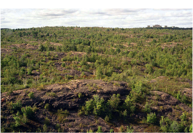
Photo 2: Aerial view of the northern boundary of the conservation reserve. Wetlands in the centre foreground consist of fen and meadow marsh. (Photo taken by B. Burkhardt, 27 August 2003)
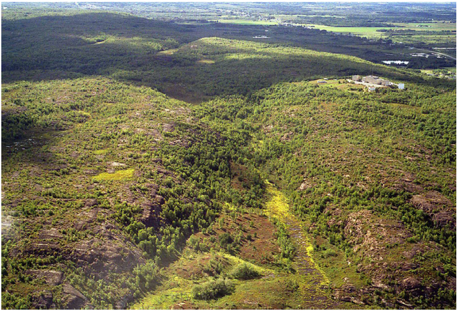
Photo 3: Exposed bedrock. (Photo taken by R. Zeran, 5 August 2004)
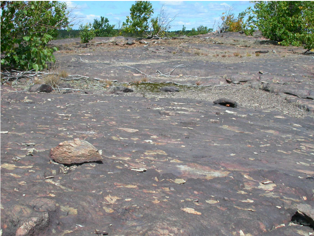
Photo 4: Exposed bedrock with young trees in the background. (Photo taken by R. Zeran, 5 August 2003)
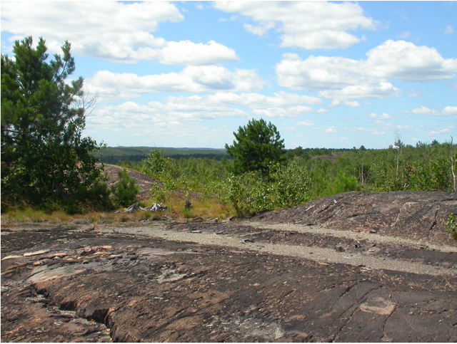
Photo 5: Exposed bedrock with scattered young white birch in foreground. Background consists of wetland. Photo taken from centre of reserve looking southward. (Photo taken by R. Zeran, 5 August 2004)
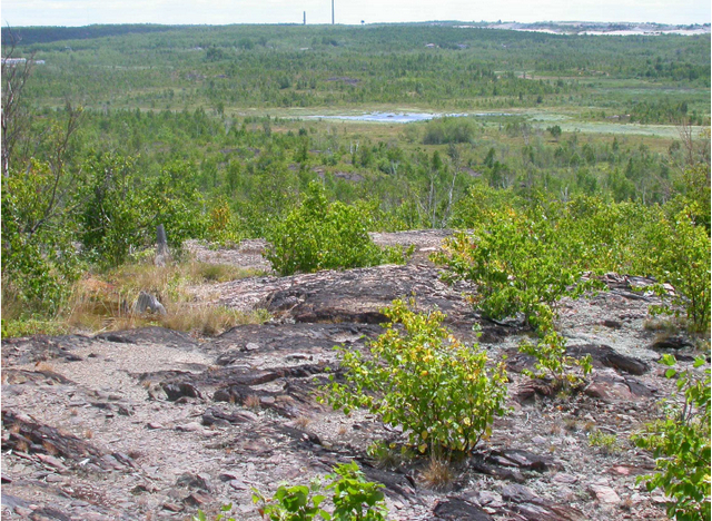
Photo 6: Blueberry (Vaccinium sp.). (Photo taken by R. Zeran, 5 August 2004)
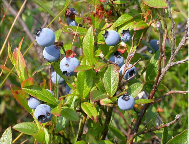
Photo 7: Large bedrock outcrop at northeast corner of conservation reserve. (Photo taken by R. Zeran, 5 August 2004)
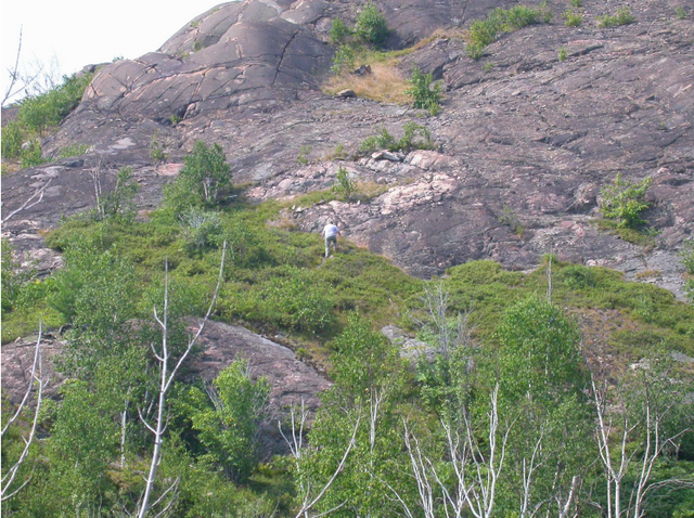
Photo 8: Wetland leading into the northeast corner of the conservation reserve. (Photo taken by R. Zeran, 5 August 2004)
Appendix C: Summary of permitted uses
The following Policy Report was obtained from the Crown Land Use Policy Atlas website during completion of this SCI (fall 2004). Changes may have been made to this policy report since that time. For the most recent version of this policy report, please refer to the Crown Land Use Policy Atlas on the internet at http://crownlanduseatlas.mnr.gov.on.ca or contact your local Ministry of Natural Resources office.
Crown land use policy atlas – policy report
C177
Garson Forest
Updated January 16, 2004
Identification:
ID: C177
Area name: Garson Forest
Area (ha): 204
Designation: Conservation reserve (Ontario’s Living Legacy)
MNR District(s): Sudbury
Description:
This conservation reserve in Site district 5E-4 supports young birch and poplar stands on top of a flat lacustrine deposit.
Garson Forest was regulated as a conservation reserve on December 7, 2002.
Land use intent:
The land use intent will be to protect the natural heritage values of this area.
Management of this area is also governed by the general policies contained in the Land Use Strategy (1999).
Management direction:
Those uses and management activities not listed in the following table are governed by existing conservation reserve policy. Over time the management direction will be elaborated in a Statement of Conservation Interest or Resource Management Plan. Any new uses, and commercial activities associated with conservation reserves, will be considered on a case by case basis, and they must pass a test of compatibility to be acceptable. Compatibility is normally determined through a planning process.
Commercial activities
| Activity | Permitted | Guidelines |
|---|---|---|
| Aggregate extraction | No | N/A |
| Bait Fishing Existing | Yes | Existing use permitted to continue, unless there are significant demonstrated conflicts. |
| Bait Fishing New | Maybe | New operations can be considered, subject to the "test of compatibility". |
| Commercial Fishing Exiting | Yes | Existing use permitted to continue, unless there are significant demonstrated conflicts. |
| Commercial Fishing New | Maybe | New operations can be considered, subject to the "test of compatibility". |
| Commercial Fur Harvesting Existing | Yes | Existing use permitted to continue, unless there are significant demonstrated conflicts. |
| Commercial Fur Harvesting New | Maybe | New operations can be considered, subject to the "test of compatibility". |
| Commercial Hydro Development | No | N/A |
| Commercial Timber Harvest | No | N/A |
| Commercial Tourism Existing | Yes | Existing authorized facilities can continue, unless there are significant demonstrated conflicts. |
| Commercial Tourism New | Maybe | New tourism facilities can be considered during the planning for an individual reserve. |
| Bear Hunting by Non-residents (guided) Existing | Yes | Existing authorized operations permitted to continue. |
| Bear Hunting by Non-residents (guided) New | No | New operations not permitted. |
| Outfitting Services Existing | Yes | Existing authorized operations permitted to continue. |
| Outfitting Services New | Maybe | New operations can be considered during the planning for an individual reserve. |
| Outpost Camps Existing | Yes | Existing authorized operations permitted to continue. |
| Outpost camps New | Maybe | New operations can be considered during the planning for an individual reserve. |
| Resorts/lodges Existing | Yes | Existing authorized facilities permitted to continue. |
| Resorts/lodges New | Maybe | New facilities can be considered during the planning for an individual reserve. |
| Energy Transmission and Communications Corridors Existing | Yes | These facilities should avoid conservation reserve lands wherever possible. |
| Energy Transmission and Communications Corridors New | No | These facilities should avoid conservation reserve lands wherever possible. |
| Food Harvesting (Commercial) Existing | Maybe | N/A |
| Food Harvesting (Commercial) New | Maybe | N/A |
| Mineral Exploration and Development | No | N/A |
| Peat Extraction | No | N/A |
| Wild Rice Harvesting Existing | Yes | N/A |
| Wild Rice Harvesting New | Maybe | N/A |
Land and resource management activities
| Activity | Permitted | Guidelines |
|---|---|---|
| Crown Land Disposition Private Use | Maybe | Sale of lands is not permitted, except for minor dispositions in support of existing uses (e.g. reconstruction of a septic system). Renewals of existing leases and land use permits are permitted. Requests for transfer of tenure will be considered in the context of the Statement of Conservation Interest or Resource Management Plan. New leases or land use permits permitted for approved activities. Tourism facilities can apply to upgraqde tenure from LUP to lease. |
| Crown Land Disposition Commercial Use | Maybe | Sale of lands is not permitted, except for minor dispositions in support of existing uses (e.g. reconstruction of a septic system). Renewals of existing leases and land use permits are permitted. Requests for transfer of tenure will be considered in the context of the Statement of Conservation Interest or Resource Management Plan. New leases or land use permits permitted for approved activities. Tourism facilities can apply to upgrade tenure from LUP to lease. |
| Fire Suppression | Yes | Fire suppression policies are similar to adjacent Crown lands, unless alternative fire policies have been developed through a planning process. |
| Fish Habitat Management | Maybe | N/A |
| Fish Stocking | Maybe | Conservation Reserves policy indicates that "featured species management" may be permitted. |
| Insect/disease Suppression | Maybe | N/A |
| Inventory/Monitoring | Yes | N/A |
| Prescribed Burning | Maybe | N/A |
| Roads (Resource Access) Existing | Yes | Existing roads can continue to be used. Continued use will include maintenance and may include future upgrading. |
| Roads (Resource Access) New | Maybe | New roads for resource extraction will not be permitted, with the exception of necessary access to existing forest reserves for mineral exploration and development. |
| Vegetation Management | Maybe | Conservation Reserves policy indicates that Featured Species Management and Natural Systems Management may be permitted. Vegetation management can be considered in a planning process. |
| Wildlife Population Management | Maybe | N/A |
Science, education and heritage appreciation
| Activity | Permitted | Guidelines |
|---|---|---|
| Collecting | No | N/A |
| Historical Appreciation | Yes | N/A |
| Nature Appreciation | Yes | N/A |
| Photography and Painting | Yes | N/A |
| Research | Yes | N/A |
| Wildlife Viewing | Yes | N/A |
Recreation activities and facilities
| Activity | Permitted | Guidelines |
|---|---|---|
| All Terrain Vehicle Use on trails | Yes | Existing use permitted to continue where it does not adversely affect the values being protected. |
| All Terrain Vehicle Use off trails | No | ATV use of trails is not permitted, except for direct retrieval of game. |
| Campgrounds | Maybe | N/A |
| Food Gathering | Yes | N/A |
| Horseback Riding (trail) | Yes | Existing use on trails permitted. |
| Hunting | Yes | N/A |
| Mountain Bike Use | Yes | Existing use on trails permitted. |
| Motor Boat Use Commercial | Yes | N/A |
| Motor Boar Use Private | Yes | N/A |
| Non-motorized Recreation Travel | Yes | N/A |
| Private Recreation Camps (Hunt Camps) Existing | Yes | Existing camps permitted to continue, and may be eligible for enhanced tenure, but not purchase of land. |
| Private Recreation Camps (Hunt Camps) New | No | N/A |
| Rock Climbing | Maybe | N/A |
| Snowmobiling on trails | Yes | N/A |
| Snowmobiling off trails | No | Except for the direct retrieval of game. Except for the direct retrieval of game. |
| Sport Fishing | Yes | N/A |
| Trail Development Existing | Yes | Development of trails for a variety of activities (e.g. hiking, cross-country skiing, cycling, horseback riding, snowmobiling) can be considered as part of planning for an individual reserve. |
| Trail Development New | Maybe | N/A |
Note: The policies outlined in this table do not supersede any Aboriginal or treaty rights that may exist, or other legal obligations.
Management of this conservation reserve is carried out within the context of Conservation Reserves policy as amended by the policies for new conservation reserves outlined in the Ontario’s Living Legacy Land Use Strategy.
Source of direction:
Ontario’s Living Legacy Land Use Strategy (1999)
Conservation Reserves Policy (1997)
Explanation of edits:
Area calculation has been edited based on current mapping. Area calculations are preliminary until public consultation on boundaries has been completed and the area has been regulated.
Appendix D: Test of compatibility
The Conservation Reserve policy provides broad direction with regard to the permitted uses. The policy provides only an indication of the variety of uses that will be considered acceptable in conservation reserves. Any new uses, and commercial activities associated with them, will be considered on a case by case basis, and, subject to the following test of compatibility. To ensure a standard screening process is followed, reviews of all current and new activities will be subject to the screening criteria as specified by the Environmental Assessment Act (R.S.O. 1900, Chapter E.18).
The following outlines the two steps involved in performing a Test of Compatibility. An assessment of current activities would only follow step two, which focuses on the impacts. An assessment of any new activity would consider the impact of the activity and its conformity to the SCI/RMP.
1. Conformity to SCI/RMP: SCI describe values for which an area has been set aside and the range of appropriate uses that will be permitted in the area. SCI may also speak to the acceptability of other 'new' uses currently not occurring in the area.
The first 'test' is: "do proposed new land uses and/or commercial activities conform to the direction of the SCI/RMP for the conservation reserve? Would the new use(s) depart from the spirit of appropriate indicator land uses in the SCI/RMP?"
2. Impact Assessment: If the proposed use(s) pass test 1 it is important to determine their impact on the area before they are approved. This should include the following:
- Impact on natural heritage values: "will the new use(s) impact any natural values in the area? If so how and to what degree? Is it tolerable?"
- Impact on cultural values: "will the new use(s) impact an historical or archaeological values in the area?"
- Impact on research activities: "will the new use(s) affect research activities in the area?" Impact on current uses: "will the new use(s) have any negative impact on the array of current uses?"
- Impact on area administration: "will the new use(s) increase administrative costs and/or complexity?" (For example, the cost of area monitoring, security and enforcement).
- Impact on accommodating the use outside the conservation reserve: "Could the use(s) be accommodated as well or better outside the conservation reserve?"
- Impact on socio-economics of the area: "will the new use(s) affect the community(ies) surrounding the area in a positive or negative way?" (For example, will the new use make an area less remote thereby affecting a local tourism industry that is dependent on the area’s remoteness for its appeal?"
- Impact on area accessibility: "does the new use(s) give someone exclusive rights to the area or a portion of the area to the exclusion of other existing uses?"
Appendix E: Amendments to the SCI
1 Ecodistricts are areas characterized by physiographic (landform) similarities, and by the successional trends exhibited by the predominant vegetation types on those physiographic features, see section 5.0- State of the Resource (Hills 1959; Crins and Uhlig 2000).
2 Disturbance rating is based on the amount of conservation reserve area currently under some form of known disturbance: >20%, high; 10-20%, medium; <10%, small (Cudmore and Longyear 2004).
3 Diversity rating is based on the size of the protected area versus the number of landforms: vegetation (SFU/HU) combinations. For conservation reserves <500 ha in size, >25 L:V combinations is considered to have high diversity, >15 L:V combinations is considered to have medium diversity, and <15 L:V combinations is considered to have low diversity (Thompson and Noordhof 2003).