Gibson River Conservation Reserve Management Statement
This document provides policy direction for the protection, development and management of the Gibson River Conservation Reserve and its resources.
C33
Statement of Conservation Interest
Ministry of Natural Resources
Parry Sound District
Prepared with the assistance of:
Meteek & Company
Huntsville, Ontario
Approval statement
We are pleased to approve this Statement of Conservation Interest for Gibson River Conservation Reserve (C33).
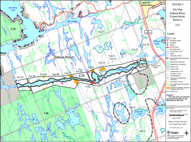
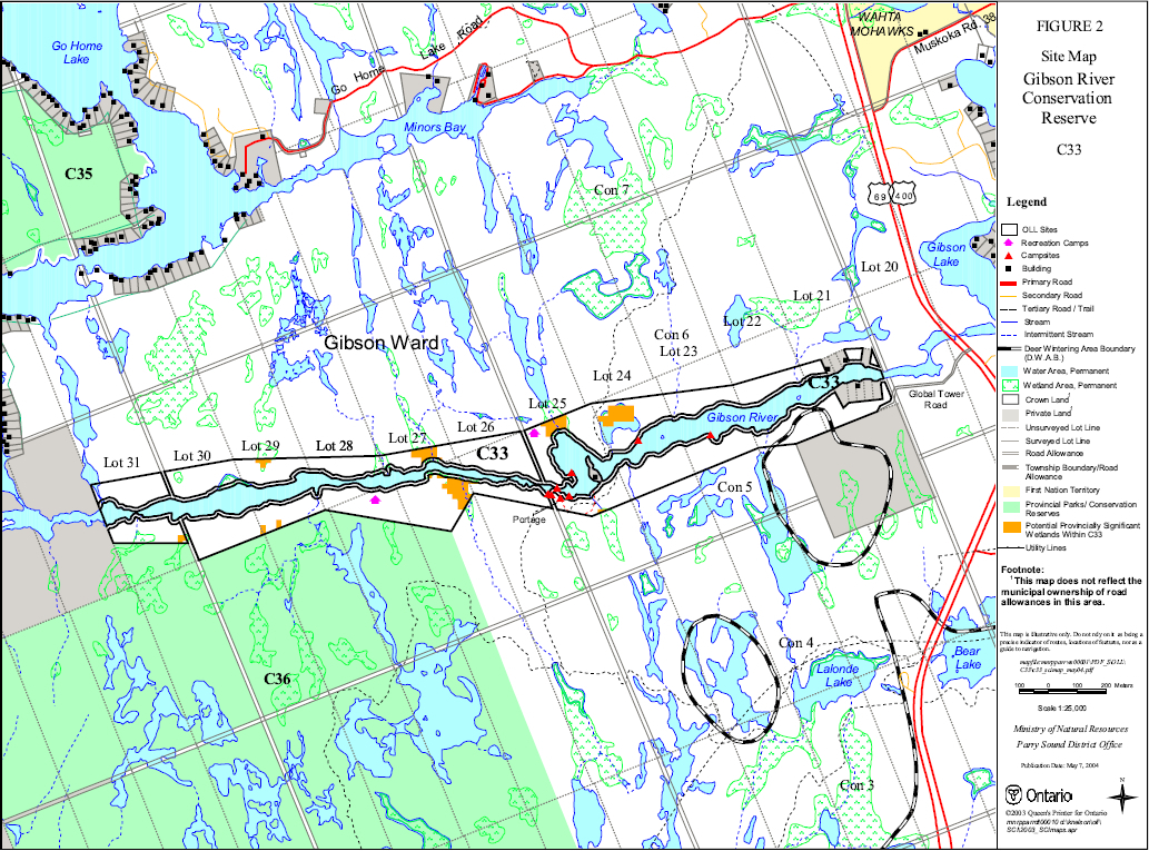
Gibson River Conservation Reserve is a 172 hectare area of Crown land that lies within Gibson Ward in the Area Municipality of the Township of Georgian Bay in the District Municipality of Muskoka. Its southern boundary abuts McCrae Lake Conservation Reserve to the south, and Cognashene Lake Conservation Reserve is only about a kilometre northwest of the west end of this site. There are private lands adjacent to this site; they are not a part of the conservation reserve.
Gibson River Conservation Reserve protects approximately 5 kilometres along the Gibson River, which is a free flowing waterway providing access to Georgian Bay, and which is popular for canoeing.
This area, which has been identified as a Muskoka Heritage Area by the District Municipality of Muskoka, contains a rich assemblage of shoreline vegetation communities, with several rare plant and animal species.
Gibson River Conservation Reserve is one of 378 new protected areas approved through Ontario’s Living Legacy Land Use Strategy, aimed, in part, at completing Ontario’s system of parks and protected areas. It is part of the Great Lakes Heritage Coast, a signature site identified through Ontario’s Living Legacy Land Use Strategy. The Great Lakes Heritage Coast is designed to protect the coastal environment and provide for recreational and tourism opportunities associated with the natural environment.
During the "Lands for Life" planning process, the public was widely consulted and provided valuable input into what became Ontario’s Living Legacy Land Use Strategy. During consultation related to the formal Public Lands Act regulation of the boundaries of this conservation reserve (in 2002) a number of minor boundary changes were made to ensure the boundaries reflected areas requiring protection. Comments received during the consultation were generally supportive of the protection of this area. Stakeholders who provided comment during the earlier consultation for this site were subsequently consulted regarding the draft Statement of Conservation Interest and their comments were considered in the finalization of this document.
This Statement of Conservation Interest provides guidance for the management of the conservation reserve and provides the basis for the ongoing monitoring of activities. More detailed direction is not anticipated at this time. Should more complex resource management or conservation issues arise or significant facility development be considered, then a detailed Resource Management Plan will be prepared with full public consultation.
Gibson River Conservation Reserve is managed under the direction of the District Manager and the Parry Sound Area Supervisor of the Ministry of Natural Resources, Parry Sound District.
Approved by:
R. Griffiths
District Manager
Parry Sound District
Approved by:
Ron Running
Regional Director
Southern Region
1.0 Introduction
Ontario’s Living Legacy, the result of an extensive planning process that began in early 1997, culminated in the approval in July 1999 of a Land Use Strategy that identifies the intended strategic direction for Crown land, including the completion of Ontario’s system of parks and protected areas. This process, which included extensive public consultation, resulted in the recommendation for regulation of 378 new protected areas, including Gibson River Conservation Reserve (C33).
Gibson River Conservation Reserve is a 172 hectare area of Crown land that lies within Gibson Ward in the Area Municipality of the Township of Georgian Bay in the District Municipality of Muskoka. Its southern boundary abuts McCrae Lake Conservation Reserve to the south, and Cognashene Lake Conservation Reserve is only about a kilometre northwest of the west end of this site. There are private lands adjacent to this site; they are not a part of the conservation reserve.
This site contributes to the protection of the environment within the Great Lakes Heritage Coast. As well, the Gibson River and nearby conservation re serves may function as an important "gateway" to Georgian Bay and the southern portion of the Great Lakes Heritage Coast. These sites can provide access to the Great Lakes Heritage Coast recreation, educational and interpretive opportunities in addition to the important role they play in the protection of natural heritage resources.
Gibson River Conservation Reserve protects approximately 5 kilometres along the Gibson River, which is a free flowing waterway providing access to Georgian Bay, and which has a long tradition of being popular for canoeing.
This area, which has been identified as a Muskoka Heritage Area by the District Municipality of Muskoka, contains a rich assemblage of shoreline vegetation communities, with several rare plant and animal species. Some of the wetland complexes in this conservation reserve have been identified, through the use of satellite imagery and other available wetlands information, as having very high potential of being provincially significant wetlands.
Located in Hills' ecological Site District 5E-7, the conservation reserve protects a significant portion of a natural corridor connecting major natural areas along the southern edge of the Canadian Shield to the vast landscape of coastal Georgian Bay. The site provides a buffer along a 5 kilometre length of shoreline on both sides of the river, protecting a combination of rocky and sandy-peaty shoreline, with several thicket swamp – meadow marsh bays.
Conservation reserves are established under the authority of the Public Lands Act, Ontario Regulation 805/94. Gibson River Conservation Reserve was established by Ontario Regulation 237/03 on June 28, 2003.
A Statement of Conservation Interest (SCI) is prepared under the direction of Procedural Guideline A – Resource Management Planning (PL. Procedure 3.03.05). The purpose of this SCI is to identify and describe the values of Gibson River Conservation Reserve. The SCI also outlines the activities that currently occur within the conservation reserve and provides guidelines for the management of current and future activities in the context of protecting the natural, recreational and cultural values.
1.1 Background information:
| Name | Gibson River Conservation Reserve (C33) |
|---|---|
| Site Region/District | 5E-7 |
| OMNR Administrative Region/District/Area | Southern Region/Parry Sound District/Parry Sound Area |
| Total Area (ha.) | 172 hectares |
| Regulation Date | June 28, 2003 (O. Reg. 237/03) |
| First Nations | Robinson-Huron Treaty and Williams Treaty |
| OBM map sheets | 10 17 5900 49750, 5900 49800 |
| Topographic Map | Penetanguishene 31D/13 |
| UTM co-ordinates | 17T 59397 498010 (Centroid) |
1.2 Representation:
Earth science representation:
Bedrock – Go Home complex, a younger granitic unit underlies this conservation reserve, which falls in the Go Home Domain, Algonquin Terrane of the Central Gneiss Belt of the Proterozoic Grenville Province.
Surficial – Bedrock overlain by thin drift characterizes this site.
Life science representation:
Gibson River Conservation Reserve supports 16 diffe rent landform-vegetation types: 5 forest types, 1 rock barren type and 10 wetland types, all within one biophysical unit VIIa-7 "Weakly broken-bare bedrock plain". It protects habitat for 8 provincially rare species and includes an example of a provincial ly, possible globally rare vegetation community type, Atlantic Coastal Plain Forb Bedrock Meadow Marsh. (Cooper & Jalava, 2001)
Cultural resources representation:
Neither detailed cultural research nor inventory has been carried out for this conservation reserve. The conservation reserve is a part of a river system, which has historical significance. Recent regional evaluation (OMNR, 2003) shows that this conservation reserve contains areas that have a high potential for cultural heritage sites. There are registered cultural heritage sites identified to the east of the conservation reserve.
Recreational Opportunities:
A recreational inventory report was prepared for this site based primarily on existing knowledge and data sources of MNR staff, recent site visits and also reflecting field observations made during the preparation of the life science report (Brown, 2003). A traditional canoe route, it is used both for day-tripping and longer trips. Canoe-in camping and picnicking are accommodated on several shoreline sites. The Gibson River offers good fishing opportunities, and the area is used for hunting. A cross-country ski trail cuts across the central part of the conservation reserve.
1.3 Survey Work:
| Survey Level | Earth Science | Life Science | Cultural | Recreational | Other |
|---|---|---|---|---|---|
| Reconnaissance | Blackburn, 2003 | Cooper & Jalava, 2001 | OMNR, 2003 | Brown, 2003 | None |
| Detailed | None | None | None | None | None |
| Requirement | None | Monitor the status/presence of significant species and associations. | Research to be encouraged. | Monitor use impacts | None |
2.0 Values to be protected
The northern portions of this conservation reserve are located within Hills' (1959) ecological Site District 5E-7. Values include earth science, life science and recreational/aesthetic values, with an emphasis on the life sciences.
2.1 Earth science:
(Earth science information, unless otherwise noted, is taken from Blackburn, 2003)
Bedrock:
Gibson River Conservation Reserve is within the Go Home Domain, Algonquin Terrane in the west ern part of the Central Gneiss Belt of the Proterozoic Grenville Province.
The Go Home Domain consists of highly deformed 1.8 to 1.6 billion-year-old gneisses and migmatites of supracrustal and igneous origin that have been intruded by younger, 1.5 to 1. 4 billion-year-old granitic and monzonitic plutons. It has been divided into two gneiss associations, the Honey Harbour gneiss association and the Pine Island Migmatites. (Culshaw et al, 1991, Easton, 1992a) The Honey Harbour gneiss association is intruded by younger granitic plutons, collectively named the Go Home complex. This conservation reserve is underlain only by rocks of the Go Home complex.
The Grenville Province is the product of thrusting and imbrication of the crust to the northwest as it collided with a continental landmass to the southeast. The Grenville Orogeny, circa 1140 to 1070 million years ago, culminated more than 500 million years of crustal evolution. The eroded roots of the products of these events are displayed in the complexly metamorphosed and deformed rocks of the region (Easton, 1992b).
The Algonquin Terrane is one of four lithotectonic terranes of the Central Gneiss Belt. Within the Algonquin Terrane, the Go Home Domain is one of twelve structural domains. This geological environment is part of the modern organization of the complex products of the mid-Proterozoic Grenville orogenic events (Easton, 1992a & b). As such, their representation in Gibson River Conservation Reserve contributes to the conservation of the Grenville continental accretion theme outlined by Davidson (1981). The rock outcrops of Gibson River Conservation Reserve are considered of regional significance.
Surficial:
Gibson River Conservation Reserve lies in the Georgian Bay physiographic region of Southern Ontario, characterized by very shallow soil and bare bedrock knobs and ridges (Chapman and Putnam, 1984). It is characterized by bedrock plain with pockets of organic terrain in low-lying areas, and thin drift over the bedrock.
No significance is attributed to the surficial geological features of this conservation reserve.
2.2 Life science:
(Life science information, unless otherwise noted, is taken from Cooper & Jalava, 2001)
Representation:
Gibson River Conservation Reserve is a corridor along the Gibson River, located in Hills' ecological Site District 5E-7. The conservation reserve protects a significant portion of a natural corridor connecting major natural areas along the southern edge of the Canadian Shield to the vast landscape of coas tal Georgian Bay. The site includes a 5 kilometre length of the shoreline on both sides of the river, protecting a combination of rocky and sandy-peaty shoreline, with several thicket swamp–meadow marsh bays.
The seasonal and yearly natural fluctuations of water levels along the river, allows for the emergence of sandy-peaty soils, predominantly in the western portion of the site, creating ideal habitat for Atlantic Coastal Plain flora. These areas are also frequented by numerous herpetofaunal species including Blanding’s turtle (Emydoidea blandingii). Upland, white pine (Pinus strobus), oak (Quercus spp), red maple (Acer rubrum) and large-tooth aspen (Populus grandidentata) forests are dominant, interrupted by several patches of exposed gneissic bedrock. In small pockets, where high moisture levels support a richer substrate, sugar maple (Acer saccharum) and silver maple (Acer saccharinum) become dominant species. In addition, minor depressions in the bedrock of upland communities support a variety of wetlands, including a Virginia chain fern (Woodwardia virginica) bog and several shrub thicket swamps.
The area is found within the interior gneissic barren rocklands physiographic region as described by Macdonald (1987) and Brunton (1993). According to current Ontario Ministry of Natural Resources (OMNR) digital biophysical mapping, Gibson River Conservation Reserve is located within one biophysical unit, "Weakly broken-bare bedrock plain (organic) VIIa-7" and its landform-vegetation types are thus characteristic of the extensive tract of bedrock that follows the eastern Georgian Bay coastline from the Severn River to the French River (Noble 1983).
The upland portion of Gibson River Conservation Reserve supports a variety of forest, rock barren and wetland types. Intermediate-aged forest communities dominated by white pine cover the greatest portion of the area, with red oak (Quercus rubra), red maple and large-tooth aspen as the main associates. Shrub and herbaceous cover is minimal, with wild-lily-of-the-valley (Maianthemum canadense) and wild Sarsaparilla (Aralia nudicaulis) being the most prevalent. Along the eastern portion of the north shore, 'fresh- moist white pine- largetooth aspen- red oak ecosite' is the dominant community type, with oc casional pockets where large-tooth aspen is replaced by red maple resulting in a 'dry to fresh white pine- red maple mixed forest'. Further west, red oak and white oak (Quercus alba) replace the large-tooth aspen resulting in a 'dry – fresh white pine – oak mixed forest type'. Along the southern shore 'dry – fresh white pine – oak mixed forest type' is the dominant community with occasional patches where red maple becomes more dominant, resulting in a 'dry – fresh white pine – red maple mixed forest'. Changes in the understorey of these forest types are uncommon, creating an almost continuous layer of mixed herb and shrub species dominated by wild-lily-of- the-valley and wild Sarsaparilla.
Changes in the topography of these upland forests allow for a scattering of several additional community types. Where there are wide gullies, runoff from the higher outcrop patches results in the accumulation of moisture, broken-down bedrock materials and organic materials. In these areas, sugar maple is common as both a dominant and associate species, and species characteristic of richer soils such as red trillium (Trillium erectum) are more common in the understorey. In more uniform bedrock depressions, small thicket swamp wetland communities are prevalent. These communities are comprised predominantly of speckled alder (Alnusincana ssp rugosa), with several associates including mountain holly (Nemopanthus mucronatus), and an herb layer dominated by royal fern (Osmunda regalis). In one location, the bedrock depression has been filled in by a Virginia chain fern (Woodwardia virginica) bog.
Along the higher ridges of the upland communities and in areas along the shoreline, small patches of rock barrens are present. Common juniper (Juniperus communis) is the dominant cover within the higher outcrops, often forming dense patches. A thin canopy of white oak is also common in these communities, as are patches of crinkled hairgrass (Deschampsia flexuosa), poverty oat grass (Danthonia spicata) and panic grass (Panicum acuminatum).
The shoreline of the conservation reserve grades from predominantly rocky shoreline to more frequent stretches of sandy shoreline approaching the western boundary of the site where water levels are much lower. Along the eastern portion of the site, upland forests regularly extend to the shoreline, where there are either small rocky cliffs or, less commonly, a patch of open rock barren. The open communities provide ideal habitat for five-lined skink (Eumeces fasciatus) which were observed inha biting one of these areas along the northern shore of the river.
Shallow bays supporting a variety of wetlands interrupt the dominant rocky shorelines on both the north and south shore. In two of the smaller bays located within the eastern half of the si te, 'silver maple organic deciduous swamp' communities are present. The canopy cover is made up of silver maple and, to a lesser extent, white birch, with sensitive fern (Onoclea sensibilis) dominant in the understorey. A third small bay consists of a 'meadowsweet mineral thicket swamp'. Meadowsweet (Spiraea alba), sweet gale (Myrica gale) and sensitive fern are the dominant species in the thicket swamp community, with patchy distribution of red- osier dogwood (Cornus stolonifera) near the perimeter. An ad jacent lily pond has 50% cover of white water- lily (Nymphaea odorata ssp odorata), bullhead lily (Nuphar variegata) and watershield (Brasenia schreberi).
Small rock islands located near the centre of the river in the eastern portion of the site support a variety of species including nesting habitat for the spotted sandpiper (Actitis macularia) and crevice cover for a population of northern water snake (Nerodia sipedon sipedon). Typical rock barren species are found near the centre of the larger island (e.g. common juniper and poverty oatgrass) as well as several small tree saplings including red maple. Closer to the shoreline, wetland species such as swamp loosestrife, marsh St. John’s-wort (Triadenum fraseri) and flat-top goldenrod (Euthamia graminifolia) are common. The smaller of the two islands is virtually absent of vegetation cover, with the exception of a few very small patches of soil supporting species such as bugleweeds (Lycopus americanus, L. uniflorus).
At the western end of the site where the confluence with the Musquash River occurs, water depth is much lower and therefore, the shallow bays located in this portion of the site support different community types. The dominant community type consists of a mosaic of two different communities; where there is newly exposed substrate, a 'Forb mineral meadow marsh' is present. Dominant species in this community include swamp loosestrife (Lysimachia terrestris), water smartweed (Polygonum amphibium) and golden hedge- hyssop (Gratiola aurea) with localized dominance of two provincially rare species, lizard’s tail (Saururus cernus) and redtop panic grass (Panicum rigidulum). Further inland, in the area less frequently inundated by seasonal high water conditions, the forb meadow marsh grades into a 'buttonbush mineral thicket swamp'. In addition to buttonbush (Cephalanthus occidentalis), winterberry is also common in this community type. Along the shorelines adjacent to these buttonbush thicket swamps examples of the provincially rare 'Atlantic Coastal Plain bedrock forb meadow marsh' community are present, dominated by redtop panic grass.
Larger bays are present within the western portion of the site, extending south and northward to wetland complexes beyond the site boundary. The smallest of these bays is seasonally flooded and supports one of the richer forest communities found in the site, 'fresh-moist sugar maple – lowland ash deciduous forest'. Dominant vegetation cover in the understorey consists of sensitive fern with more patchy distribution of American fly-honeysuckle (Lonicera canadensis). In the most open bay, both 'Willow mineral thicket swamp' and 'narrow-leaved sedge mineral meadow marsh' communities are present. The meadow marsh makes up the majority of the bay and is covered almost exclusively by an unidentified sedge (Carex sp.). The willow thicket swamp occurs in localized patches, with pussy willow (Salix discolor) as the dominant cover. Watershield, bullhead lily and pickerel weed (Pontederia cordata) are common within the open inlet that runs through the centre of the community. The other larger bay is located in one of the more narrow sections of the river. The dominant community in this bay is a 'willow mineral thicket swamp', with meadow willow (Salix petiolaris) as the dominant shrub cover and inflated sedge (Carex vesicaria) as the dominant herbaceous cover.
Condition:
Forest communities along both shorelines range in age from young to intermediate with some indication of localized burning or logging in the past. With the exception of fluctuations in the river’s water level, the wetland communities within the site show no obvious indication of recent disturbance. Recreational use is moderately heavy in this area however impact on the flora and fauna appears to be low.
Diversity:
Gibson River Conservation Reserve supports 16 different landform-vegetation types: 5 forest types, 1 rock barren type and 10 wetland types, all within one biophysical unit.
As documented during the 2001 field season, the site supports 238 different vascular plant species, 12 of which are not native to Ontario (5% of total plant species). In addition this site supports at least 23 species of breeding birds (including the provincially vulnerable red-shouldered hawk), 2 species of non-breeding birds and 5 species of reptiles (1 of which is provincially rare).
Ecological considerations:
Gibson River Conservation Reserve protects a portion of the corridor connecting Gibson Lake to open Georgian Bay. The Gibson River is the main waterway flowing from Gibson Lake and several adjacent wetland complexes found to the north and south of the site boundaries. In addition, it acts as the floodplain for waters flowing out of Gibson Lake (Reid and Bergsma 1994). The extensive exposed shoreline communities in the western portion of the site depend on the maintenance of natural water fluctuations to ensure the protection of habitat for provincially rare fauna and flora.
More than 5 kilometres of shoreline on each side of the Gibson River are protected within this site. The extensive exposed shoreline found along the northern and southern shore of the western portion of the conservation reserve provides ideal habitat for Atlantic Coastal Plain species and currently supports a large and healthy population of redtop panic grass. This habitat is also ideal for turtle species, including the provincially rare Blanding’s Turtle. Rock outcrops found in patches along the entire shoreline provide habitat for several other reptile species. Both the northern water snake and the provincially rare five-lined skink (Eumeces fasciatus) were seen inhabiting this community type and observations of the provincially rare eastern massasauga rattlesnake in a shallow bay community just beyond the site’s western boundary indicate that this species likely inhabits similar communities within the conservation reserve
Special features:
Gibson River Conservation Reserve includes several high quality examples of buttonbush – sweet gale thicket swamps along the shores, near the western boundary of the site. Small pockets of Atlantic Coastal Plain bedrock communities were also observed but not described.
This site has been identified as a Muskoka Heritage Area by the District Municipality of Muskoka, based on life science values (Reid & Bergsma 1994).
Some of the wetland complexes in this conservation reserve have been identified, through the use of satellite imagery and other available wetlands information, as having very high potential of being provincially significant wetlands (Ducks Unlimited Canada and OMNR, 2003).
2.3 Cultural values:
No specific cultural studies or inventories have been undertaken within the conservation reserve, and no major cultural resource values have been evaluated or identified to date. The conservation reserve is a part of a river system, which has historical significance. Recent regional evaluation (OMNR, 2003) shows that this conservation reserve contains areas that have a high potential for cultural heritage sites. There are registered cultural heritage sites identified to the east of the conservation reserve.
2.4 Recreational/Aesthetic Values:
Gibson River Conservation Reserve has a long tradition as a canoe route, used both for day tripping and longer trips. Canoe-in camping and picnicking are accommodated on several shoreline sites. The Gibson River provides access to Georgian Bay and also offers good sport fishing opportunities.
The site is used for hunting, with two authorized recreation camps within the conservation reserve.
A cross-country ski trail, part of an extensive network of rugged back-country trails, cuts across the central part of the conservation reserve.
The use of snowmobiles and all-terrain vehicles seems to be for access along unauthorized trails, rather than as a recreat ional pursuit.
The distance of this conservation reserve from urban areas has resulted in a relatively pristine night sky, which enhances the sense of remoteness and wilderness of this site. Pristine night skies are considered a significant value, given t he increasingly limited areas of southern and central Ontario which are not heavily affected by light pollution.
3.0 Management guidelines
3.1 Land tenure:
Background:
Gibson River Conservation Reserve comprises 172 hectares of Crown land in Gibson Ward in the Area Municipality of the Township of Georgian Bay in the District Municipality of Muskoka. There are private lands adjacent to this site (and in one case, surrounded by it); they are not a part of the conservation reserve.
Two municipal road allowances cross this site, and municipal shore road allowances run the full distance of the conservation reserve, on both sides of the river. These road allowances are under municipal jurisdiction, and are not a part of the conservation reserve.
The conservation reserve is within OMNR Bear Management Area PS-46-17, registered trapping area PS-150, and commercial Baitfish Block PS0215.
There are two recreation camps within the conservation reserve, authorized by land use permit under the authority of the Public Lands Act, Ontario Regulation 805/94.
The conservation reserve is traversed by a Five Winds Backcountry Touring Club cross-country ski trail, authorized by land use permit; this is part of an extensive network of rugged back-country trails. Other unauthorized trails are used by snowmobiles and all-terrain vehicles to gain access to adjacent private lands, and to an authorized recreation camp.
Guideline:
The sale of Crown lands within the conservation reserve generally is not permitted. Exceptions will only be considered under unusual circumstances, such as where an adjacent privately owned parcel has inadequate area for the installation of a septic system.
There are no plans by the MNR to acquire private lands to add to the conservation reserve.
The commercial bear hunting service associated with the current Bear Management Area is allowed to continue. Fur harvest is permitted to continue in the registered trapline area. Bait harvest is permitted to continue in the Bait Fish Block.
The existing recreation camps within the conservation reserve are permitted to continue. They may be eligible for "enhanced" tenure, but are not eligible for purchase of land. (See Appendix 4)
New recreation camps are not permitted.
Commercial timber harvesting is not allowed within conservation reserves. However, there are limited situations in which abutting land owners can harvest firewood for use on their adjacent property. Specifically, property owners and recreation camp permittees who have no road access to their properties can apply for permits to cut limited amounts of firewood in the conservation reserve for their own use. This situation would apply only to water access cottages or recreation camps that are adjacent to conservation reserve boundaries, and that do not have road access.
3.2 Development:
Background:
There are no Crown owned buildings or other facilities within the conservation reserve.
Access to the conservation reserve is generally by canoe, from the east near Highway 69, or from Georgian Bay to the west. There are campsites and picnic areas scattered at various locations along the shoreline within the site.
Currently, an unauthorized all-terrain vehicle trail provides access to an authorized recreation camp, and other trails provide all-terrain vehicle and snowmobile access to adjacent private land. Generally, the terrain of the conservation reserve does not lend itself to the development of such trails.
The Five Winds Backcountry Touring Club cross-country ski trail crosses the central portion of this conservation reserve.
Guideline:
This site contributes to the Great Lakes Heritage Coast initiative by providing important protection to the coastal environment. Implementation of the Great Lakes Heritage Coast may provide for the future consideration of upgrading recreational and interpretive facilities including access, trails, and campsites. New facilities will only be considered where either long-term funding is available, or a long-term partnership will provide for long-term management of the facilities. All facility improvements will ensure the protection of natural values of this site, will meet MNR's Environmental Assessment Act requirements, including requirements for public consultation, and will comply with Procedural Guideline B – Land Uses – Test of Compatibility (see Appendix 1). Major new facility development will involve public consultation.
New roads or driveways for resource extraction and/or private use will not be permitted, nor will additions to existing roads, or up grading of existing roads be permitted. There is no intention to develop roads outside of the conservation reserve to improve access to this site.
The development of new docks and water systems for adjacent or surrounded private lands is not restricted by the establishment of the conservation reserve. The MNR will consider site specific values when a work permit is required for such work.
The existing authorized cross-country ski trail may be permitted to continue in this conservation reserve as long as it does not impair the natural features and values for which the area is identified and as long as there are no significant environmental impacts. Its use will be monitored to ensure that conservation reserve values are not being adversely impacted.
New recreational trails may be considered on a case by case basis provided that they meet Procedural Guideline B – Land Uses – Test of Compatibility (see Appendix 1) and the MNR's Environmental Assessment Act requirements. Public consultation will generally be required during the consideration of changes to existing trails, and will always be required for new trails. New recreational trails will not be permitted in or within 120 metres of the wetlands that have been assessed as having high potential to be provincially significant wetlands unless it has been demonstrated that there will be no negative impacts on the natural features or the ecological functions of the wetland.
New recreational trails for motorized vehicles will not be permitted, unless the following have been demonstrated:
- there is a community need for the trail, as well as community support
- there are no alternative suitable locations outside the conservation reserve
- the trail location would be acceptable and suitable for four-season use
- the trail would meet the requirements applicable to all trails, as identified in the preceding paragraph
The use of unauthorized recreation trails that existed at the time of regulation of this conservation reserve, and the increase in use of all-terrain vehicles, will be monitored to ensure that conservation reserve values are not being adversely impacted. Depending on the results of monitoring, some of the unauthorized trails may need to be redirected from sensitive areas or eliminated completely. Otherwise, there is no intent to mark or upgrade these trails.
Unauthorized works within the conservation reserve will be handled in accordance with the Public Lands Act, and any required removal of improvements will be at the expense of those responsible.
No mineral exploration is permitted within this conservation reserve. This policy decision is based on a commitment made by the Ministry of Natural Resources and the Ministry of Northern Development and Mines in March 2002. This policy direction replaces that identified in the 1999 Ontario’s Living Legacy Land Use Strategy, which stated that controlled mineral exploration would be permitted in new conservation reserves which were identified as having provincially significant mineral potential.
Any new development must meet MNR's commitments to protect cultural heritage values (see Section 3.7). While there is no intent at present to provide or permit any new development in this conservation reserve that would require lighting, should this be considered at some point in the future the MNR will not allow unnecessary, undirected light pollution. This commitment recognizes the wilderness values provided by a pristine night sky.
3.3 Recreational activities:
Background:
The main recreation use of this site is water travel, either for long trips or for day visits. Associated picnicking and camping occurs along the shoreline on a few well used sites. Other activities include sport fishing and hunting, and cross country skiing. The use of snowmobiles and all-terrain vehicles seems to be for access, rather than as a recreational pursuit.
Guideline:
Canoeing, along with its associated camping and picnicking, will continue to be a primary use of this site. Campsite location and condition will be documented, and monitored, and overused sites may require closure and/or relocation.
Hunting and sport fishing are permitted to continue within the conservation reserve.
Recreational use such as hiking, wildlife viewing, snowshoeing, and cross-country skiing, will be allowed to occur in the conservation reserve. The authorized cross-country ski trail will be allowed to continue. Upgrading or changes in the route may be considered on a case by case basis provided the changes meet the Procedural Guideline B – Land Uses – Test of Compatibility (Appendix 1) and the MNR's Environmental Assessment Act requirements.
Unauthorized trails that existed at the time of regulation of this conservation reserve (whether recreation trails or access trails), and any increase in their use will be monitored to ensure that conservation reserve values are not being adversely impacted. Depending on the results of monitoring, some trails may need to be redirected from sensitive areas or eliminated completely. Otherwise, there is no intent to mark or upgrade these trails.
Off-trail use of snowmobiles and all-terrain vehicles is only permitted for the direct retrieval of game. Off-trail use will be monitored to ensure that the conservation reserve values are not being adversely impacted.
As discussed in Section 3.2 Development, new recreational trails may be considered on a case by case basis provided that they meet Procedural Guideline B – Land Uses – Test of Compatibility (see Appendix 1) and the MNR's Environmental Assessment Act requirements. Public consultation will generally be required during the consideration of changes to existing trails, and will always be required for new trails. New recreational trails will not be permitted in or within 120 metres of the wetlands that have been assessed as having high potential to be provincially significant wetlands unless it has been demonstrated that there will be no negative impacts on the natural features or the ecological functions of the wetland. Any new trails must meet MNR's commitments to protect cultural heritage values (see Section 3.7).
New recreational trails for motorized vehicles will not be permitted, unless the following have been demonstrated:
- there is a community need for the trail, as well as community support
- there are no alternative suitable locations outside the conservation reserve
- the trail location would be acceptable and suitable for four-season use
- the trail would meet the requirements applicable to all trails, as identified in the preceding paragraph
New recreati onal activities will be considered on a case by case basis provided they are consistent with maintaining the values of the conservation reserve and comply with Procedural Guideline B – Land Uses – Test of Compatibility (Appendix 1). Emphasis will be placed on activities that have a low impact on the environment of the conservation reserve.
Monitoring of existing and permitted activities will be undertaken as required to ensure that the conservation reserve values are not being adversely impacted.
3.4 Commercial activities:
Background:
There has been no recent commercial forest harvesting or mining activity within the conservation reserve.
Commercial fur harvesting is authorized through registered trapline. The guiding of non-resident bear hunters is authorized through Bear Management Area, and bait fish harvesting is authorized through Bait Fish Block licence within the conservation reserve. These were discussed under Section 3.1 Land Tenure–Background.
Guideline:
Fur harvesting, bear hunting services and bait fish harvesting operations will be allowed to continue within the conservation reserve. New trapline cabins are not permitted within conservation reserves.
Mineral exploration is not allowed in this conservation reserve, as discussed in Secti on 3.2.
Conservation reserve regulations do not permit mining, commercial forest harvesting, hydroelectric power development, the extraction of aggregate and peat or other industrial uses (Public Lands Act, Ontario Regulation 805/94). Other new commercial activities must meet the requirements of Procedural Guideline B – Land Uses – Test of Compatibility (see Appendix 1).
The retrieval of sunken logs from the Gibson River may be permitted, subject to meeting the requirements of MNR's Forest Management Procedure FOR 03 03 01, "Applications for Retrieval of Sunken Logs – Review and Approval Requirements". This process ensures that potential impacts are considered, along with potential mitigation measures, and also includes public consultation.
3.5 Aboriginal interests:
Background:
This site is known to be of interest to many First Nation communities. There are 2 treaties associated with the area: the Robinson – Huron Treaty of 1850 and the Williams Treaty. A Supreme Court decision in 1994 (Howard) validated that the Williams Treaty surrendered hunting, fishing and trapping rights of those First Nations affiliated with that treaty.
Guideline:
The regulation and management of this conservation reserve will not impede the exercise of existing aboriginal or treaty rights. These rights include hunting, fishing, fur harvesting, gathering of plants for a variety of purposes, and the use of ceremonial sites. It is recognized that the manner in which these rights are carried out is not limited to the manner i n which they were carried out in the past, but has evolved over time with changes in technology.
It is recognized that if a First Nation land claim affecting a portion of this site is determined to be valid, the conservation reserve designation is not irreversible and does not preclude consideration of these lands in the settlement of a claim. If deregulation of part or all of a conservation reserve occurs as part of the settlement of a claim, this will be carried out at no cost to First Nations.
3.6 Natural resource stewardship:
Background:
Vegetation management for specific purposes is not known to have occurred in the past. Wildlife and fisheries management, particularly sport fishing, hunting and fur harvesting, have been occurring according to the prevailing policies and legislation.
The emphasis will be on ensuring that the natural values of the conservation reserve are not negatively affected by current and future activities. Therefore, applications for new specific uses will be carefully studied and reviewed. Necessary studies may be undertaken by proponents, the Ministry, and/or partner organizations.
Guideline – Vegetation:
The intent of this site is to allow the existing vegetation communities to evolve naturally. The Ministry will continue to monitor for the status/presence of significant species and associations.
The OMNR recognizes fire as an essential process fundamental to the ecological integrity of this conservation reserve. In accordance with existing conservation reserve policy and the Forest Management Strategy for Ontario, forest fire protection will endeavour to use "light on the land" techniques, which do not unduly disturb the landscape, in this conservation reserve. Examples of light on the land techniques may include limiting the use of heavy equipment, and limiting the number of trees felled during fire response efforts. Input from the local MNR Area Supervisor would be solicited if a forest fire threatens the area. Opportunities for prescribed burning to achieve resource management objectives may be considered. Plans for any prescribed burning will be developed in accordance with the OMNR Prescribed Burn Planning Manual.
Programs may be developed to control forest insects and diseases in the conservation reserve where these threaten significant values in or adjacent to the site. Where insects or disease threaten significant values, in or adjacent to the site, and MNR determines that control is warranted, control within the conservation reserve will be directed by the MNR as narrowly as possible to the specific insect or disease. Biological control will be used wherever possible. In all cases, regard shall be had for Procedural Guideline B – Land Uses – Test of Compatibility (see Appendix 1).
Guideline – Wildlife and fisheries:
The relevant Ontario hunting and fishing regulations will guide hunting and fishing within Gibson River Conservation Reserve. Fur harvesting and bait fishing will be managed through the maintenance of the current licensing system.
The Ministry will monitor the impacts of activities of snowmobile and all-terrain vehicles on the natural values of the conservation reserve.
3.7 Cultural resource stewardship:
Background:
Recent regional evaluation (OMNR, 2003) shows that this conservation reserve contains areas that have a high potential for cultural heritage sites. There are registered cultural heritage sites identified to the east of the conservation reserve. The river is known to be a traditional water travel route. However, no specific studies or inve ntories have been undertaken within the conservation reserve, and no specific significant cultural resource values have been evaluated or identified to date.
Guideline:
Should the MNR consider either carrying out or permitting new structural development, significant clearing of vegetation or altering of land within this conservation reserve, the MNR will adhere to the cultural heritage resource screening process as is identified in its Memorandum of Understanding (MOU) with the Ministry of Culture. While the purpose of this MOU is to provide a process to identify and protect cultural heritage resources when the MNR is reviewing work permits or disposing of Crown rights under the authority of the Public Lands Act, the considerations and criteria would also enable the MNR to identify high potential cultural heritage areas for other purposes within conservation reserves. If the screening process indicates that the site of a proposed activity is within an area of high cultural heritage potential, the MNR will consult with the Ministry of Culture to determine the appropriate cultural heritage assessment requirements and will undertake a preliminary archaeological assessment if appropriate.
Interested partners will be encouraged to undertake inventories, studies, and research to document the histories of First Nations, settlement, resource harvest/management and recreation in the area. The MNR will discuss the appropriateness of any proposed archaeological assessment with local First Nations and the Ministry of Culture.
3.8 Client services:
Background:
Access to the conservation reserve has generally been confined to traditional uses for the current commercial and recreational activities. There are no Crown facilities or services developed on or adjacent to the conservation reserve. The information fact sheet for this conservation reserve is currently available to the public through the Parry Sound District Office, or via the Internet at www.ontarioslivinglegacy.com.
Guideline:
The focus will remain on low key information and self-interpretation of conservation reserve values and features. Consideration will be given to the preparation of an information brochure (with map) to highlight the features for which the area was identified and appropriate uses to ensure the protection of those features.
Those producing future canoe route maps or descriptions should be encouraged to identify the conservation reserve, and appropriate user ethics while within the site.
3.9 Research:
Background:
Research to date has included the preparation of a number of check sheets to document life science values, earth science values, and recreation potential and values.
Guideline:
Research focussing on the prehistoric and historic use of the conservation reserve and its vicinity will be encouraged.
Research focussing on the assessment of use and activity impacts on sensitive species and habitats will be encouraged.
All research will be carried out in a non-destructive manner. Research proposals must follow Procedural Guideline C – Research Activities in Conservation Reserves (Appendix 3).
3.10 Marketing:
Background:
There has been no marketing of this conservation reserve to date. Promotion and information about this site has been primarily through the Ontario’s Living Legacy planning process and recent MNR Parry Sound District public consultation regarding the boundaries of this site.
Guideline:
Marketing activities of this conservation reserve will be kept to a minimum. This site may be the subject of marketing as part of the Great Lakes Heritage Coast initiative.
4.0 Implementation
Administrative responsibility for this conservation reserve belongs to the Parry Sound Area Office of the Parry Sound District of the Ministry of Natural Resources. The Area Office will continue to have the custodial care of Gibson River Conservation Reserve. Emphasis will be placed on awareness information highlighting reserve values, and monitoring and managing the current approved uses.
Priorities will include:
- Ensure compliance to prescribed management direction of the approved Statement of Conservation Interest
- GPS location of existing unauthorized trails and classify their status and condition
- Monitor and evaluate existing and allowed recreational and commercial use levels and impacts as required to ensure that conservation reserve values are not being adversely impacted
- Encourage research and studies focusing on the prehistoric and historic use of the conservation reserve and its vicinity
- Encourage further inventory and research of the significant life science resources of the conservation reserve
- Encourage research about significant flora and fauna species and communities, and potential impact on these by various recreation activities; this will include evaluation of the wetlands using the Ontario Wetland Evaluation System Northern Manual (1993), to confirm its potential as a provincially significant wetland
- Support cooperative ongoing education of resource users with respect to resource and land stewardship values, in order to maintain the ecological integrity of the site and to provide long term recreational opportunities
- Provide client services (e.g. brochure or fact sheet) at nearby MNR offices
5.0 Review and revision of the Statement of Conservation Interest
This Statement of Conservation Interest will be amended through a standard process of minor and major amendments. Minor amendments will be processed in a relatively informal manner and will require the approval of the Area Supervisor. These amendments will deal with uses and activities that do not affect any of the policies in this SCI (e.g. new uses and/or activities that are consistent with existing permitted uses).
Uses and/or activities that were not anticipated in the approved SCI and which may have an impact on the values of the conservation reserve will require a major amendment. This will include an opportunity for public comment and input, and will require the approval of the District Manager and Regional Director.
6.0 References
Blackburn, C. E. 2003. C33 Gibson River Conservation Reserve. Earth Science Report, OMNR Peterborough.
Brown, B. 2003 Recreation Resource Inventory Report. Gibson River Conservation Reserve. OMNR Parry Sound.
Brunton, D. F. 1993. Life Science Areas of Natural and Scientific Interest in Site District 5E-7. OMNR, Algonquin Region, Huntsville.
Cooper, W. and Jalava, J. 2001. Natural Heritage Area – Life Science Checksheet Gibson River Conservation Reserve. OMNR, Parry Sound.
Chapman, L. J. and Putman, D. F. 1984. Ontario Geological Survey, Special Volume 2, The Physiography of Southern Ontario, Third Edition. OMNR.
Crins, W. J. and Kor, P. S. G. 1998. Natural Heritage Gap Analysis Methodologies Used by the Ontario Ministry of Natural Resources. Unpubl ished Paper. Peterborough: OMNR.
Davidson, R. J. 1981. A framework for the conservation of Ontario’s earth science features. Ontario Ministry of Natural Resources, Toronto.
Ducks Unlimited Canada and OMNR. 2003. Enhanced Wetland Mapping and Evaluation for Ontario’s Forested Shield. In Preparation for the District of Muskoka.
Easton, R. M. 1992a. The Grenville Province and the Proterozoic history of central and southern Ontario; in Geology of Ontario, Ontario Geological Survey, Special Volume. 4, Part 2.
1992b. Tectonic evolution of Ontario. Part 3: Mesoproterozoic evolution of the southeast margin of Laurentia; in Geology of Ontario, Ontario Geological Survey, Special Volume 4, Part 2.
Hills, G. A. 1959. A Ready Reference to the Descriptio n of the Land of Ontario and its Productivity. Ont. Dept. of Lands and Forests, Division of Research, Maple, Ontario.
Noble, T. W 1983. Biophysiographic Analysis, Site Region 5E, Algonquin Region, Ministry of Natural Resources. Algonquin Region, Huntsville.
Ontario Ministry of Natural Resources. 1999. Ontario’s Living Legacy: Land Use Strategy. Queen’s Printer for Ontario.
2003. Cultural Heritage Registered Site Reserves and Areas of High Potential, Parry Sound District, Scale 1:150000.
Reid, R. and B. Bergsma. 1994. Natural Heritage Evaluation of Muskoka. Muskoka Heritage Areas Program. Bracebridge, Ontario.
Appendices
Appendix 1
Procedural Guideline B – Land Uses – Test of Compatibility (PL Procedure 3.03.05)
The conservation reserve policy provides broad direction with regard to the permitted uses. The policy provides only an indication of the variety of uses that will be considered acceptable in conservation reserves. The only caution is that "any new uses, and commercial activities associated with them, will be considered on a case by case basis, and, they must pass a test of compatibility to be acceptable." What does a 'test of compatibility' mean?
An examination of this must start from the premise of why an area is set aside – specifically, its representative natural heritage values. Criteria are then identified to guide compatibility considerations. These criteria apply to the long-term acceptability of both existing uses and new uses.
-
Conformity to SCI/RMP: SCI describe values for which an area has been set aside and the range of appropriate uses that will be permitted in the area. SCI may also speak to the acceptability of other 'new' uses currently not occurring in the area.
The first 'test' is: "do proposed new land uses and/or commercial activities conform to the direction of the SCI/RMP for the conservation reserve? Would the new use(s) depart from the spirit of appropriate indicator land uses in the SCI/RMP?"
- Impact Assessment: If the proposed use(s) pass test 1 it is important to determine their impact on the area before they are approved. This should include the following:
- Impact on natural heritage values: "will the new use(s) impact any natural values in the area? If so how and to what degree? Is it tolerable?"
- Impact on cultural values: "will the new use(s) impact an historical or archaeological values in the area?"
- Impact on research activities: "will the new use(s) affect research activities in the area?"
- Impact on current uses: "will the new use(s) have any negative impact on the array of current uses?"
- Impact on area administration: "will the new use(s) increase administrative costs and/or complexity?" (For example, the cost of area monitoring, security and enforcement)
- Impact on accommodating the use outside the conservation reserve: "Could the use(s) be accommodated as well or better outside the conservation reserve?"
- Impact on socio-economics of the area: "will the new use(s) affect the community(ies) surrounding the area in a positive or negative way?" (For example, will the new use make an area less remote thereby affecting a local tourism industry that is dependent on the area’s remoteness for its appeal?"
- Impact on area accessibility: "does the new use(s) give someone exclusive rights to the area or a portion of the area to the exclusion of other existing uses?"
The following table (Appendix 2) provides a guide of indicator uses for the consideration of uses that may be permitted within conservation reserves. For any specific conservation reserve that test of compatibility should be applied to determine which specific uses are acceptable.
Appendix 2
Indicator uses for Conservation Reserves: Generic and specific
Recreation
| Activities | Generic Policy Permitted? Existing | Generic Policy Permitted? New | Specific Application in Gibson River Conservation Reserve |
|---|---|---|---|
| Sport fishing | Yes | Yes | Yes |
| Sport hunting | Yes | Yes | Yes |
| Food gathering | Yes | Yes | YesA |
| Facility infrastructure | Maybe | Maybe | Maybe |
| Off-trail snowmobiling | No1 | No1 | No1 |
| Off-trail all-terrain vehicle use | No1 | No1 | No1 |
| Rock climbing/caving | Maybe | Maybe | N/A |
| Canoeing/kayaking | Yes | Yes | Yes |
| Motorized boating | Yes | Yes | Yes |
| Picnicking | Yes | Yes | Yes |
| Camping | Yes | Yes | Yes |
| Trails: Hiking | Yes | Maybe | MaybeB |
| Cross country skiing | Yes | Maybe | MaybeB |
| Cycling | Yes | Maybe | MaybeB |
| Horse riding | Yes | Maybe | MaybeB |
| Snowmobiling | Yes | Maybe | MaybeB |
| All-Terrain Vehicles | Yes | Maybe | MaybeB |
Science, education & heritage appreciation
| Activities | Generic Policy Permitted? Existing | Generic Policy Permitted? New | Specific Application in Gibson River Conservation Reserve |
|---|---|---|---|
| Research | Yes | Yes | Yes |
| General walking | Yes | Yes | Yes |
| Photography & Painting | Yes | Yes | Yes |
| Wildlife viewing | Yes | Yes | Yes |
| Outdoor Education/Interpretation | Yes | Yes | Yes |
| Collecting | No | Maybe2 | Maybe2 |
Commercial activities
| Activities | Generic Policy Permitted? Existing | Generic Policy Permitted? New | Specific Application in Gibson River Conservation Reserve |
|---|---|---|---|
| Food harevesting | Maybe | Maybe | No |
| Fishing | Maybe | Maybe | No |
| Baitfish harvesting | Yes2 | Maybe | Yes |
| Fur harvesting | Yes2 | Maybe | Yes |
| Trap cabins | Yes | No | MaybeC |
| Resort- outpost camp | Yes2 | No | No |
| Outfitting- bear management | Yes2 | No | Yes |
| Wild rice harvesting | Yes | Maybe | Maybe |
Resource management
| Activities | Generic Policy Permitted? Existing | Generic Policy Permitted? New | Specific Application in Gibson River Conservation Reserve |
|---|---|---|---|
| Inventory monitoring | Yes | Yes | Yes |
| Featured species management | Maybe | Maybe | Maybe |
| Natural systems management | Maybe | Maybe | Maybe |
| Insect and disease control | Maybe | Maybe | Maybe |
Industrial activities
| Activities | Generic Policy Permitted? Existing | Generic Policy Permitted? New | Specific Application in Gibson River Conservation Reserve |
|---|---|---|---|
| Timber harvesting | No | No | No |
| Mineral exploration | No | No | No |
| Mining | No | No | No |
| Hydro generation | No | No | No |
| Energy transmission corridors | Yes | No4 | No4 |
| Communications corridors | Yes | No4 | No4 |
| Public transportation corridors | Yes | No4 | No4 |
| Resource access roads | Maybe | No | No |
| Private access roads | Maybe | No | No5 |
Other activities
| Activities | Generic Policy Permitted? Existing | Generic Policy Permitted? New | Specific Application in Gibson River Conservation Reserve |
|---|---|---|---|
| Land Disposition | Maybe6 | No6 | No6 |
| Recreation Camps | YesC | No3 | YesC,D |
Appendix 3
Procedural Guideline C
Research activities in Conservation Reserves (PL Procedure 3.03.05)
Purpose
To encourage contributions to the goal of conservation reserves by:
- Providing direction for research activities associated with conservation reserves; and
- Establishing a process for the review and approval of proposals by researchers, which could have an impact on the values protected by the conservation reserve
Definition
Research means any investigation or study of the natural, cultural, economic, management or other features or characteristics of conservation reserves.
Guidelines
Research will be encouraged to provide a better understanding of the natural val ues protected by a conservation reserve and to advance their protection, planning and management. The Statement of Conservation Interest will define, for each conservation reserve, the key research issues, set out the parameters within which research may occur and identify research needs.
Applications and approvals
Researchers must apply in writing to the Area Supervisor for permission to conduct research. The request letter must contain a statement explaining why the proposed research should be undertaken in the particular conservation reserve in preference to another location.
Proposals will be reviewed and approved by the Area Supervisor, guided by the SCI prepared for each reserve (see Guideline A – Resource Management Planning) and using Guideline B – Land Uses – Test of Compatibility. Permission must be granted in writing, including any conditions to be met in conducting the research, prior to the undertaking of any research project.
Term and conditions
Permission to conduct research und er this policy will be valid for a period of 12 consecutive months from the date of issue. Permission to continue a research project for an additional period of 12 months or less may be granted upon submission of a written request and a progress report. The Ministry may require the posting of collateral to assure that the terms and conditions of granting permission are met.
The Area Supervisor may suspend or revoke permission at any time for failure on the part of the researcher to meet:
- The intent of this policy.
- The requirements under the Public Lands Act, Ontario Regulation 805/94, including all amendments, where applicable.
- The requirements under any other Act or regulations of Ontario or Canada, including those governing the taking, handling, storing, confining, fur harvesting, excavating and marketing any specimen, artefact, information or action (for example, scientific collector’s permit).
- The conditions and agreements specified in granting permission.
Final Report
The researcher will subm it copies of reports, publications and theses following the results of the project to the Area Supervisor.
Appendix 4
Recreation camp tenure
Existing recreation camps within conservation reserves are generally permitted to continue. They may be eligible for "enhanced" tenure, but are not eligible for purchase of land. There are 2 forms of enhanced tenure that may be considered (as per September 22, 2000 direction from MNR's Assistant Deputy Ministers of Natural Resource Management and of Field Services):
- upgrade in the nature or type of tenure (e.g. from a Land Use Permit to a lease) and/ or
- an extension in the term of the tenure (e.g. from 1 year to 10 years).
Applications for enhanced tenure will be approved if determined acceptable using these screening criteria:
- Must follow the review process identified in MNR's land disposition policies:
- MNR District Manager must ensure that there will be no serious, foreseeable resource management or user conflicts as a result of the enhanced tenure;
- The intended use/activity will not likely impact on Goal 1, 2 or 3 of the Provincial Policy Statement, issued under Section 3 of the Planning Act;
- The site conforms with the MNR's land use planning direction;
- The disposition is reviewed under the Environmental Assessment Act's Exemption Order MNR 26/7;
- The site is not within a Provincial Significant Wetland (PSW). If the site is adjacent to a PSW it must be determined that the proposed enhancement of tenure will not have a negative impact on the function or natural features of the wetland;
- If the site is on lake trout lake, a lease will only be considered after such time as the policy on development on such lakes has been approved;
- Would not result in increased negative impact on natural heritage, cultural heritage or recreational values of the conservation reserve, or on existing authorized land uses;
- Must be subject to consultation with affected First Nations, and be consistent with any aboriginal land claim negotiations or protocol agreements;
- All rents, taxes, fees, rates or charges must be paid up.
A change in tenure does not convey a commitment to provide for, or agree to, a change in the type or the standard of existing access to the recreation camp.
Figure 1: Location Map
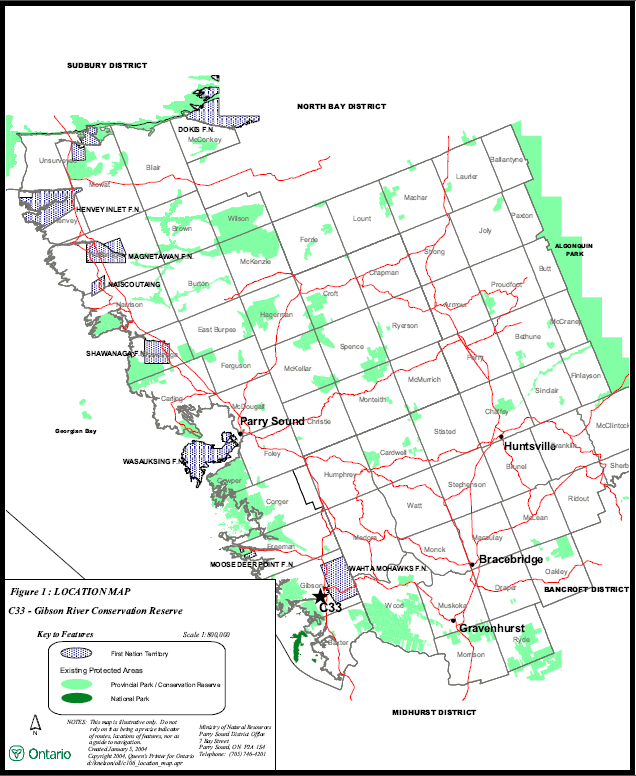
Figure 2: Site Map
Notes:
On generic policy application in conservation reserves:
1 For direct retrieval of game only.
2 Only as a part of an approved research project.
3 Transfer requests will be considered in the context of the Statement of Conservation Interest or Resource Management Plan for each conservation reserve.
4 Existing use is permitted to continue. New transportation corridors, communications lines, and
transmission lines are discouraged in conservation reserves except under unusual circumstances where there are no other viable alternatives.
5 New private roads, including additions to existing roads, will not be permitted except where there are existing commitments.
6 Sale of Crown lands in conservation reserves is not permitted, except for certain minor dispositions (e.g. sale of small parcel of land where adjacent private lot is too small to enable installation of a septic system, or to facilitate legal title to lands where there has been a long-standing encroachment of a dwelling on Crown land) where they do not detrimentally affect the values an area is intended to protect.
On specific policy application in Gibson River Conservation Reserve:
A Food gathering is permitted for personal consumption only and must be conducted in a sustainable manner, and such that it does not harm the values of the conservation reserve.
B Existing authorized recreational trails are permitted to continue in conservation reserves as long as there are no significant environmental impacts and they do not impair the natural features and values for which the area is identified. Additional high impact recreational trails are discouraged, but new trails may be considered on a case by case basis, provided they comply with Procedural Guideline B – Land Uses – Test of Compatibility (Appendix 1), and the MNR’s Environmental Assessment Act requirements.
C Existing authorized uses can continue. New cabins, outpost camps and private recreation camps are not permitted.
D Existing authorized recreation camps are eligible for enhanced tenure, but not for the purchase of lands. A decision to grant enhanced tenure or to transfer recreation camps will be addressed through a screening process.