Gooderham Old Growth White Pine Forest Conservation Reserve Management Statement
This document provides policy direction for the protection, development and management of the Gooderham Old Growth White Pine Forest Conservation Reserve and its resources.
Statement of Conservation Interest
July 2002
Administrative Update Approved: July, 2017
Ontario Ministry of Natural Resources
North Bay District
Executive summary
Approved Statement of Conservation Interest for Gooderham Old Growth White Pine Forest Conservation Reserve (C137).
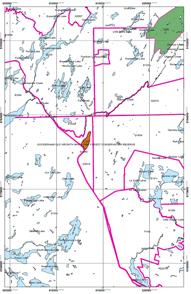
The Gooderham Old Growth White Pine Forest Conservation Reserve has been selected as a site representing old growth white pine and associated plant communities. This conservation reserve offers an ecological landscape representative of the Southern Boreal Site Region. Furthermore, it contributes a richness of cultural and social values, and fulfills many social requirements both locally and provincially. Further studies are required to identify other possible ecological associations and their significance. This conservation reserve is 82 hectares in size and borders Ottertail Creek and the Ontario Northland Rail Line in the unincorporated township of Gooderham. The site is also adjacent to the Nipissing Crown Game Preserve, which lies to the west.
Gooderham Old Growth White Pine Forest Conservation Reserve is one of 378 new protected areas approved through Ontario’s Living Legacy Land Use Strategy (1999), a strategy aimed in part, at completing Ontario’s system of parks and protected areas - The site is regulated under the Provincial Parks and Conservation Reserves Act (PPCRA) and associated regulations and guidelines.
Once a conservation reserve is regulated, the Ministry of Natural Resources and Forestry (MNRF) will complete one of two approved planning documents, either a Statement of Conservation Interest (SCI) or a Resource Management Plan (RMP). Both documents address the administration of landuses and activities that occur within the regulated boundaries of the conservation reserve. The Gooderham Old Growth White Pine Forest Conservation Reserve experienced no new issues, conflicts, uses and/or proposals beyond those addressed during land use planning for the Ontario’s Living Legacy Land Use Strategy. As a result, a SCI was completed. For conservation reserves having more complex issues, a RMP would be required.
When considering future permitted uses and/or developments, these must be consistent with the SCI. New uses are evaluated within the context of, but may not be limited to; Test of Compatibility, and all current Environmental Assessment (EA) requirements. Other protocols may be developed that address site specific sensitivities to identified features.
The goal of the Gooderham Old Growth White Pine Forest SCI is to describe and to protect natural and cultural heritage values while permitting compatible land use activities.
The purposes of this SCI are to:
- Provide background information and identify and describe the values of the Gooderham Old Growth White Pine Forest Conservation Reserve
- Provide guidelines for the management of current and future activities while protecting natural, social, and cultural heritage value
During the preparation of Lands for Life planning process, the public was widely consulted and provided valuable input into what became Ontario’s Living Legacy Land Use Strategy (1999). Comments received during that time, and consultation related to the formal Public Lands Act regulation of the boundaries of this conservation reserve, were generally supportive of the protection of this area. Stakeholders who provided comment during the boundary consultation for this site were consulted regarding the draft Statement of Conservation Interest, and their comments were considered in the finalization of this document.
This SCI will be examined as per the schedule outlined in the PPCRA (Statues of Ontario) and to determine if the management direction is relevant, effective and current, as well as to identify what information may require updating or amending to ensure adequate protection of the site’s values.
The district will evaluate the significance of the required changes. Administrative updates to the SCI may be considered and approved by the District Manager and Regional Director without further public consultation. In assessing amendments, Indigeneous Community consultation will occur. Such amendments will follow the planning process outlined in the Protected Areas Planning Manual (OMNRF 2014).
The management and administration of the Gooderham Old Growth White Pine Forest Conservation Reserve will be guided by the SCI and administered by the North Bay District MNRF. The SCI governs the lands within the regulated boundary of the Gooderham Old Growth White Pine Forest Conservation Reserve; however, to ensure MNRF protection objectives are being fully met within the conservation reserve, activities on the surrounding landscape must consider the site’s objectives and heritage values. In addition, it is the intent of the SCI to create a public awareness that will promote responsible stewardship of protected areas and their surrounding lands in Ontario. With management partners such as Ontario Parks, industry, local governments, etc., the ministry will be able to pursue and advance sound environmental, economic and social strategies and policies related to the protection of this conservation reserve.
Approval statement
I am pleased to approve this Statement of Conservation Interest for the Gooderham Old Growth White Pine Forest Conservation Reserve (C 137).
This Statement of Conservation Interest (SCI) will provide guidance for the management of the conservation reserve and the basis for the ongoing monitoring of land use and resource activities. This conservation reserve is one of 378 new protected areas approved through Ontario’s Living Legacy Land Use Strategy (1999), a strategy aimed in part, at completing Ontario’s system of parks and protected areas.
The Gooderham Old Growth White Pine Forest Conservation Reserve offers a landscape with representative life and earth science features, of which the most notable feature is the old growth white pine forest.
Direction for establishing, planning and managing conservation reserves is defined under the Provincial Parks and Conservation Reserves Act (PPCRA) and associated regulations and guidelines. The direction for managing this conservation reserve is in the form of a SCI, which defines the area that is being planned, provides the purpose for which the conservation reserve has been proposed, and outlines the Ministry of Natural Resources and Forestry’s (MNRF) intent for the protected area. This SCI will provide both guidance for the management of the conservation reserve and the basis for ongoing monitoring of activities. More detailed direction at this time is not anticipated. However, should significant facility development be considered or complex issues arise requiring additional studies, more detailed management direction will be prepared with full public and Indigenous Community consultation.
Public and Indigeneous Community consultation occurred prior to the regulation of this conservation reserve during the planning for Ontario’s Living Legacy. Furthermore, there was a 15-day review period in November 2002 concerning a draft of this SCI. Comments from the review period have been considered in the development of this document.
The management and administration of the Gooderham Old Growth White Pine Forest Conservation Reserve will be guided by this SCI. Although significant changes to the current pattern of land use activities and resource management practices are not envisioned, more intensive recreational activity and/or scientific study and resource management practices may require a change in management direction and potentially amendments to this plan.
The Gooderham Old Growth White Pine Forest Conservation Reserve will be managed under the direction of the District Manager, North Bay District, Ministry of Natural Resources and Forestry (MNRF).
Original signed by: D.A. Payne
District Manager Recommendation
For Approval
Date: Jan. 20, 2003
Original signed by: G.R. for Rob Galloway
Regional Director
Date: Feb. 13, 2003
Administrative update
Approved by:
Mitch Baldwin
North Bay District Manager
Date: July 21, 2017
Corrinne Nelson
Northeast Regional Director
Date: July 24, 2017
1.0 Introduction
The following document is a Statement of Conservation (SCI) for Gooderham Old Growth White Pine Conservation Reserve (C284). The purpose of this SCI is to identify and describe the natural, recreational and cultural values of Gooderham Old Growth White Pine Conservation Reserve and to outline the Ministry of Natural Resources and Forestry’s (MNRF) management intent for this area. The first portion of this document highlights the provincial context in which it was produced, states its goal and objectives, and summarizes the planning process for conservation reserves. The remainder of this document specifically addresses Gooderham Old Growth White Pine Conservation Reserve. Management direction provided within this SCI will serve to protect the conservation reserve for the benefit of all Ontario residents. This direction will comply with the land use intent stated in the Ontario’s Living Legacy Land Use Strategy (OMNR 1999) and the Provincial Parks and Conservation Reserves Act (PPCRA) (Statutes of Ontario 2006).
Ontario boasts a varied and diverse landscape. Many demands are placed on its resources for both social and economic benefit. The value of these resources was recognized as part of the preparation of Ontario’s Living Legacy Land Use Strategy (1999) for the management of 39 million hectares of Crown lands and waters in a planning area covering 45 % of the province. This strategy is committed to completing Ontario’s system for protected areas, recognizing the land use needs of the resource-based tourism industry and enhancing angling, hunting and other Crown land recreation opportunities.
The Gooderham Old Growth White Pine Forest Conservation Reserve has been selected as a conservation reserve as part of this strategy. The MNRF has established conservation reserves as a tool to protect natural heritage areas on public lands, while permitting traditional public land uses to continue. These uses include recreation activities, such as hunting and fishing, and the traditional activities of Aboriginal societies, as defined under applicable Aboriginal Treaties. Lands regulated as conservation reserves under the PPCRA (Statutes of Ontario 2006) are removed from the Sustainable Forest Licence, and mining and surface rights are withdrawn from staking under the Mining Act (RSO 1990 Chapter M.14).
Ontario’s Living Legacy Land Use Strategy (OMNR 1999) and the PPCRA (Statutes of Ontario 2006) and associated regulations outline the general land use policy and management direction for conservation reserves; however, each conservation reserve has a planning document, such as this SCI, which details site-specific management direction.
The preparation of a Statement of Conservation Interest (SCI) is a means in which to identify the values of this conservation reserve and to set out guidelines for the management of current and future activities while protecting the natural, social and cultural heritage values of the conservation reserve.
This document has been prepared in accordance with MNRF's policy for Conservation Reserves. In addition to recognizing a number of existing uses, this SCI provides the opportunity for new uses, which may be considered, provided they meet the Test of Compatibility, set out in the MNRF policy. However, given that the conservation reserve is small, remote and not easily accessible, the potential for new uses is limited.
This SCI governs all lands within the regulated boundary of the Gooderham Old Growth White Pine Forest Conservation Reserve. MNRF recognizes the need to work with other Ministries and/or proponents of adjacent land use activities, to encourage minimizing the potential risk of negative impacts on the conservation reserve. It is recognized that public awareness and public education will play a role in the stewardship of all protected areas and it is essential to pursue and promote sound environmental, economic and social strategies to reinforce the principles of wise stewardship.
2.0 Goal and objectives
2.1 Goal of the Statement of Conservation Interest
The goal of the Gooderham Old Growth White Pine Forest Conservation Reserve SCI is to provide the framework and direction to guide management decisions affecting Gooderham Old Growth Conservation Reserve.
2.2 Objectives of the Statement of Conservation Interest
2.2.1 Short term
- To identify the State of the Resource with respect to natural heritage values and current land use activities for the conservation reserve.
- To outline MNRF’s management intent for the protected area.
- To manage the conservation reserve to protect the integrity of its natural values via specific guidelines, strategies and prescriptions detailed in this plan.
- To meet planning requirements by designing this SCI document to address the immediate planning and management needs of the conservation reserve.
- To create public awareness of the values within this conservation reserve by providing information on the resources that it contains and protects; and to promote responsible stewardship of the protected area through partnerships with local stakeholders.
- To provide direction for the evaluation of proposed new uses or economic ventures through the application of the PPCRA (Statues of Ontario 2006), the Protected Area Compatibility Test (Appendix A) and the Class Environmental Assessment for Provincial Parks and Conservation Reserves (OMNR 2005). These review processes will evaluate the impact of proposed use(s), either positive or negative, on the protected values of the conservation reserve.
2.2.2 Long term
- To establish representative targets (e.g. future forest conditions) and validate the site as a potential scientific benchmark.
- To give direction to evaluate future new or economic ventures (i.e. through use of a Test of Compatibility evaluation).
- To determine the long-term management goals for the conservation reserve by identifying research, client services, and marketing strategies necessary to position this conservation reserve among the system of parks and protected areas in Ontario.
3.0 Management planning
3.1 Planning context
3.1.1 Planning Area
The planning area for this SCI is the regulatory boundary of the conservation reserve. As noted earlier MNRF encourages the consideration of conservation reserve values in land use and resource management activities on the surrounding landscape. Any strategies noted within this plan related to the conservation reserve boundary or beyond, will be presented for consideration within a larger planning context such as a forest management plan (FMP).
3.1.2 Management planning context
Ontario’s Living Legacy Land Use Strategy (1999) provides the context for planning for protected areas within the system of parks and protected areas. The categorization of land use areas, their associated goals, objectives and permitted uses are reflected in this SCI. Conservation reserves, which are created by regulation under the Provincial Parks and Conservation Reserves Act, are managed by policies and procedures set out in the Conservation Reserves Policy and Procedure, 1997.
Management direction for a new conservation reserve must be completed within five years of the conservation reserve’s regulation date. The guidelines used for the preparation of this basic SCI was Procedural Guideline A – Resource Management Planning (Conservation Reserves Procedure PL3.03.05, Public Lands Act), which has since been replaced by Ontario’s Protected Areas Planning Manual (OMNR 2014).
The Gooderham Old Growth White Pine Forest Conservation Reserve was regulated as a conservation reserve on December 21, 2000, by Ontario Regulation 686/00 and subsequently regulated under the PPCRA (Statutes of Ontario 2006) by Ontario Regulation 315/07 on June 9, 2008.
Existing permitted uses within conservation reserves may continue, unless they are shown to have a significant negative impact on the values protected by the site. Review/evaluation mechanisms are in place to address proposed new permitted uses, or land use proposals.The Protected Area Compatibility Test (Appendix A) and/or other standard MNRF environmental screening processes, such as the Class Environmental Assessment for Provincial Parks and Conversation Reserves (OMNR 2004), are used to screen proposals.
With respect to cultural resources, proposals are screened using A Technical Guideline for Cultural Heritage Resources for Projects Planned Under the Class Environmental Assessment for MNRF Resource Stewardship and Facility Development Projects and the Class Environmental Assessment for Provincial Parks and Conservation Reserves (OMNR 2006).
3.2 Planning process
Once a conservation reserve is regulated, there is a need to determine the level of management planning required to fulfil protection targets. The SCI is a directional document that provides background information, identifies values to be protected and establishes management guidelines for the conservation reserve. The SCI was selected since there were no new issues beyond those addressed during land use planning for Ontario’s Living Legacy or during consultation prior to site regulation.
The implementation of policy will be the responsibility of the MNRF at the district level. Associations with various partners may also be sought to assist in the delivery of the management program for the conservation reserve. It should be noted that the SCI is a working document and it will be necessary to make revisions to it from time to time. If changes are required, they will occur through a standard process of administrative updates or amendments.
4.0 Background information
4.1 Location and site description
4.1.1 Location
The following table describes the location and provides administrative details of the conservation reserve:
| Name | (C137) Gooderham Old Growth White Pine Forest Conservation Reserve |
|---|---|
| OMNR Administrative Region/District/Area |
Northeast/North Bay |
| Total Area | 82 ha (202 ac.) |
| Townships | Gooderham |
| Municipality | Gooderham – Unincorporated for Municipal Purposes |
| Site Region- Site District (Hills, 1959) | 5E-6 |
| Land Ownership | 100% Crown Land |
| Topographic Maps | 31 L/13 Ingall Lake |
| Ontario Base Maps | 2017 6100 51800 |
| Latitude | 46° 46' N |
| Longitude | 79° 31' E |
| UTM Coordinates | 5180000 N 614000 E |
| First Nations | Robinson-Huron Treaty |
| WMU | 41 |
| Regulation Date | December 21, 2000 O. Reg 686/00 Subsequently regulated under O. Reg 317/07 of the PPCRA when it came into effect in 2006. |
| General | Adjacent to and east of the ONR Rail line and Ottertail Creek |
4.1.2 Site Description
4.1.2.1 Physical Description
The Gooderham Old Growth White Pine Forest Conservation Reserve is a 82 ha (202 ac.) parcel of Crown land which borders Ottertail Creek and the Ontario Northland Rail Line in the unincorporated geographic township of Gooderham. The site also borders the Nipissing Crown Game Preserve, which lies to the west.
Access into this conservation reserve is very limited. Ottertail Creek, although not a designated canoe route, provides seasonal access by canoe i.e. early spring and late fall. There is limited access from the east via a forest access road. This route terminates approximately 3 km from the site. There is also an established roadway located approximately 6 km south and west of the area, which terminates on the western side of the Ontario Northland Railway tracks (at Diver).
Within the conservation reserve the landscape exhibits limited topographic relief and is for the most part low lying. The mean elevation is 1,000 a.s.l. with lower areas exhibiting creek valleys and wetland areas. The area is fairly well protected by surrounding streams and wetlands. Three sides of the reserve have vectored boundaries, which are for the most part located within wetland areas.
The upland areas of the conservation reserve are predominated by stands of old growth white pine interspersed with other species (white birch, white spruce and white cedar) while the low lying areas are typically wetland (alder – sphagnum – leatherleaf swamps).
The conservation reserve contains a moderate number of vegetation-landform communities whose diversity lies in the structure and mosaic of ecosystems.
There are few human disturbances within the area and these are generally limited to canoeing along Ottertail Creek, trapping and hunting.
4.2 Administrative description
The Gooderham Old Growth White Pine Forest Conservation Reserve was passed into regulation on December 21, 2000 (O. Reg 686/00).
4.3 Inventories
The following table indicates what survey work has been done within the conservation reserve and what is required:
| Survey Level | Reconnaissance | Detailed | Future Requirements |
|---|---|---|---|
| Life Science | Merchant, B., Thompson, J.E., & Lajeuness, M., Natural Heritage Area - Life Science Checksheet, November 23, 2001. | N/A | Data analysis and classification of vegetative communities, especially origin of old growth white pine stands. Determine site’s potential as an Inventory Monitoring Assessment Reporting (IMAR) site. |
| Earth Science | Kristjansson, F.J., Interim Earth Science Checklist, December 10, 2001 | N/A | N/A |
| Recreational | Roberts, S.K., Recreational Inventory Checksheet, 2002. | N/A | N/A |
| Map Resources |
MNRF Map Series: |
N/A | N/A |
5.0 State of the resource
5.1 Representation
Life science features
The Gooderham Old Growth White Pine Forest Conservation Reserve typically exhibits stands of white pine ranging between 120-150 years old. It forms a super canopy of about twice the height of the main canopy. The lower canopy consists of white birch with some cedar and white spruce. Understorey vegetation shows this site to be ES13.2 (Jack Pine-White Pine-Red Pine-fresh to moist) in the Central Ontario Forest Ecosystem Classification (Chambers et al, 1997). In the Northeastern classification system it would be ES19 (White Pine- Red Pine Mixedwood).
The lowlands at the southeast and to the northwest are predominantly alder – sphagnum – leatherleaf swamps. Tall shrub shore fens and sedge mats occur along the moving water, and richer vegetation and thicket swamps occur along the upland interface. Just above the interface, white cedar, white spruce and white pine occur on moist soils. Also present, at the northwest end, are cedar, white spruce, larch and black spruce lowlands, classed as ES13r (White Cedar- Black Spruce-organic soil species rich) in the Northeast, and ES33 (White Cedar- Other Conifer) in Central Ontario. The southwest corner is mainly composed of a poplar stand.
Earth science features
Kristjansson (2001) describes this area as being underlain by formations of Bedrock-Drift Complex, Glaciofluvial Outwash Deposits, and Organic Deposits. The Bedrock-Drift Complex dominates the site (i.e. southwest, southeast and northeast quadrants). Numerous bedrock knob or knoll forms with intervening lower elevation areas occur in the area. Although bedrock is exposed in the upper flanks of some of the steeper knobs or knolls, a thin but relatively continuous cover of sandy till appears to be draped over these bedrock forms.
The remaining portions of the conservation reserve, particularly the northwest quadrant and the extreme west part of the southwest quadrant, are dominated by lowland topography. These are for the most part immediately underlain by deposits of glaciofluvial outwash sediment. The glaciofluvial outwash deposits, in turn, appears to be locally overlain by organic deposits, probably the result of a high water table producing a complex of wet and dry ground conditions. The relatively extensive area of organic materials situated in the central west part of the conservation reserve is representative of this particular situation. The area of organic deposits located in the extreme south part of the conservation reserve effectively demarcates the alluvial plain of Ottertail Creek.
5.1.1 Quality of the representation
The quality of the representation or the current characteristics of the natural features found within a conservation reserve are as important as the overall representative features that are being protected. A number of factors are considered in evaluating the quality of a conservation reserve’s representative features. They include diversity, condition, ecological factors, special features and current land use activities.
(a) Diversity
Diversity is a measure of the conservation reserve’s earth and life science heterogeneity. The evaluation is based on the number and range (variety) of the landscape features and landforms for earth science values and the relative richness and evenness of the site’s life science components. There are three landforms or earth science features represented within the conservation reserve including a bedrock drift complex with bedrock controlled upland topography, glaciofluvial outwash and organic deposits. The conservation reserve contains numerous bedrock knobs or knoll forms with intervening lower elevation areas. Although the bedrock is exposed in the upper flanks of some of the steeper knobs or knolls, a thin but relatively continuous cover of sandy till appears to be draped over these bedrock forms. This adds to the life science diversity of the conservation reserve. A minimum of 13 landform/vegetation combinations can be found within this conservation reserve. This richness, based on the number of cover types, is moderate for such a small site. The proportion of cover types is somewhat skewed towards the white birch mixed-woods that make up about 40% of the site. However, most forest stands observed show dominant poplar or black spruce communities.
When recognizing diversity levels within the conservation reserve, it is noteworthy to mention that much of this lies in the structure and mosaic of the ecosystems. Wildlife habitat is supplied by the declining white birch and some of the white pine – dead tops, standing snags with woodpecker holes and downed woody debris. The structural diversity of the main forest is high. Surrounding lowlands vary from rich to poor, from treed to open, from moving water to swamps.
(b) Condition
The conservation reserve is in good condition and is largely undisturbed. Most of the white pines are in excellent condition, with full healthy crowns forming a super canopy of about 30 % cover. The white birch, which forms a canopy under the white pine, is now in decline. This phenomena is more noticeable towards the site’s northern boundary. The open canopy has allowed the regeneration to start moving into the sub-canopy. Regeneration includes small amounts of white pine, white spruce and white birch, but is mainly composed of dense balsam fir.
(c) Ecological factors
The conservation reserve’s small size and narrow configuration will make future management somewhat problematic, in that there is limited protection for its core values (mainly old growth). The vectored boundaries, the relatively small size of the protected area and the small number of forest communities reduce the site’s ability to buffer adjacent land use activities. Three sides of the conservation reserve are vectored along wetlands. This may help with the protection and the management of the conservation reserve. The conservation reserve connects with the Nipissing Crown Game Preserve. Although its southern boundary is the Ottertail Creek, access to the conservation reserve occurs via the Ontario Northland railway tracks on the west side of the creek.
The white pine and the associated old growth values have the potential to continue with little change for decades. The present vegetation indicates that successful processes will eventually lead to the more common mixedwood.
(d) Special features
The conservation reserve contains two special features including the old growth white pine and wildlife values such as standing snags and downed woody debris.
Ottertail Creek was historically a canoe route and was used by Indigeneous peoples, explorers and fur traders as a connection between the Ottawa River and the Temagami River system.
(e) Current land use activities
The remote location of the conservation reserve has limited the number of land use activities. These are known to include hunting, trapping and possibly canoeing (water levels and frequent channel obstructions likely limit this use).
The conservation reserve is in a bear management area (NB-41-19) and is accessible for this species as well as for other sport hunting permitted on Crown land. The proximity of the Nipissing Crown Game Preserve makes the area popular for hunting.
A registered trap line (NB-09) also encompasses the area.
Ottertail Creek is currently used to access two hunt camps outside of the conservation reserve.
None of the land use activities have notable impact on the internal values of the conservation reserve.
There are no mining, timber harvesting, aggregate extraction or utility activities within the conservation reserve.
The conservation reserve is located within a baitfish harvest area (Gooderham Township) that is currently assigned.
(f) Summary
The Gooderham Old Growth White Pine Forest Conservation Reserve contains a moderate number of vegetative communities of which the old growth white pine forest is the most significant and the reason for the designation of the conservation reserve. This feature is important for life science study. The conservation reserve is in good physical condition and is host to a limited number of outdoor recreational activities such as hunting and canoeing, and to very limited commercial activity in the form of trapping. The area has some inherent cultural heritage value given the significance of Ottertail Creek as a historic canoe route between the Ottawa River and the Temagami River system.
5.2 Social/Economic interest in the area
(a) Linkage to local communities:
The Gooderham Old Growth White Pine Forest Conservation Reserve consists entirely of Crown land. Its limited accessibility limits its use for hunting, trapping, baitfish harvesting and canoeing. The conservation reserve has limited suitability for many activities given its small size and limited vegetation/landform diversity.
As an old growth forest, there is the potential for nature appreciation and educational opportunities.
(b) Heritage Estate contributions:
The Gooderham Old Growth White Pine Forest Conservation Reserve contributes to the province’s parks and protected areas system through its regulation, representation and the long-term management of its natural heritage values.
By allocating these lands to the parks and protected areas system through regulation, the province has ensured a certain level of permanence by distinguishing the conservation reserve and its values from the larger general use or more extensively managed landscape. In addition, the conservation reserve’s natural features are, and will be available for present and future generations to enjoy and explore.
The conservation reserve’s ecological features make a number of contributions to the province’s natural heritage estate. Its old growth white pine and other mixed communities contribute significantly to the provincial parks and protected areas system. Its relatively remote location helps to buffer adjacent land use activities and allow for a certain level of backcountry opportunities and experiences.
Long-term management must consider public access to the conservation reserve and its protection objectives. Future managers will have to balance between maintaining the quality of the current representation and the needs of recreational and other users.
(c) Indigeneous groups
All Aboriginal and treaty rights will continue to be respected throughout the management of this SCI. Any future proposal(s) and or decision(s) that have potential impact(s) on the individual aboriginal values and or communities will involve additional consultation with the affected aboriginal groups.
(d) Mining industry
There are no known current mining interests related to the conservation reserve. Mining and surface rights have been withdrawn from staking within the conservation reserve’s boundaries under the Mining Act (RSO 1990 Chapter M.14).
(e) Forest management
No commercial forest harvesting is permitted in conservation reserves nor are personal use permits issued for wood harvesting. Commercial harvesting is permitted in adjacent areas, which form part of the Nipissing Forest Management Plan. Harvesting activities are subject to work plans approved by the Ministry of Natural Resources and Forestry within prescribed harvesting practices.
(f) Utilities
There are no commercial utilities associated with the conservation reserve.
5.3 Natural heritage stewardship
Preliminary analysis of the life science targets based on landform/vegetation combinations showed that the conservation reserve contains 13 such combinations, perhaps more. The most significant features include old growth stands of white pine, wetlands and additional mixed wood stands.
A recent aerial reconnaissance survey showed no wide spread forest disturbance due to forest harvesting, insect, wind throw, wildlife damage, ice storms or other natural disturbances. Successional decay of the old growth forest is occurring here, as a more mixed stand composition results from the opening canopy.
5.4 Fisheries and wildlife
There have been no detailed wildlife studies undertaken within the conservation reserve, with the exception of some values monitoring. The importance of the conservation reserve to wildlife species has yet to be determined, particularly for those species, and habitats thereof, that may be vulnerable, threatened or endangered.
Should any vulnerable, threatened or endangered (VTE) wildlife and/or plant species be identified within or adjacent to the conservation reserve, their value will be protected. Although the species may be identified as residing within the site, their location will remain undisclosed.
5.5 Cultural heritage stewardship
According to the Ministry of Tourism and Culture’s Standards and Guidelines for the Conservation of Provincial Heritage Properties (MTC 2010), cultural heritage resources include: built heritage resources, cultural heritage landscapes, and archaeological sites.
There are no archeological sites identified within the conservation reserve. The North Bay District MNRF is not aware of any cultural heritage resources within this conservation reserve.
5.6 Land use/Existing development
There are no permanent buildings found in or near the Gooderham Old Growth White Pine Forest Conservation Reserve. The North Bay District MNRF is not aware of any cultural heritage resources within this conservation reserve.
5.7 Commercial use
Present commercial use activities are illustrated in the Commercial Activities Map. A registered trapline overlaps the conservation reserve. Gooderham Township is licensed to commercial baitfish harvesting. Additionally, the conservation reserve falls within a bear management area.
5.8 Tourism/Recreation use/Opportunities
Presently, there is no known infrastructure supporting any recreational or commercial activity within the conservation reserve boundaries.
Recreational activities such as hunting and trapping occur within the conservation reserve.
Access is by canoe (via Ottertail Creek) or from the adjacent rail line, which provides a walk-in route. There are no trails within the conservation reserve.
5.9 Research values
Currently no known research and/or monitoring activities have occurred within this conservation reserve.
5.10 Client services
Presently, client services include district responses to public inquiries. No formal information or interpretive facilities currently exist within the conservation reserve. There are fact sheets available to the public, which summarize information for this conservation reserve.
6.0 Management guidelines
6.1 Management planning strategies
The land use intent outlined in Ontario’s Living Legacy Land Use Strategy (1999) provides context and direction to land use, resource management, and operational planning activities on Crown land. Commitments identified in the above strategy and current legislation as outlined in the PPCRA (Statutes of Ontario, 2016) and associated regulations, as well as the Ontario Living Legacy Land Use Strategy (OMNR 1999) and associated policy clarification statements, will form the basis for land use within Gooderham Old Growth White Pine Forest Conservation Reserve. Management strategies for these uses must consider the short and long-term objectives for the conservation reserve. For up to date information on permitted uses refer to the Crown Land Use Atlas.
The conservation reserve will be managed by allowing natural ecosystems and associated processes to occur naturally, with minimal human interference.
Proposed uses and development will be reviewed on a case-by-case basis against the PPCRA (Statutes of Ontario 2006) and the Class Environmental Assessment for Provincial Parks and Conservation Reserves (OMNR 2005). In addition, all new proposals are subject to the Protected Area Compatibility Test (Appendix A). The emphasis will be on ensuring that the natural values of the conservation reserve are not negatively affected by current or future land use activities. Therefore, any application for new specific uses will be carefully studied and reviewed. The Ministry, partner organizations and/or proponents may undertake such studies.
6.2 State of the resource management strategies
Administrative responsibility for the Gooderham Old Growth White Pine Forest Conservation Reserve lies with the District Manager of the MNRF's North Bay District. Implementation of this SCI will primarily involve monitoring activities to ensure adherence to the management guidelines. The following management strategies have been created to achieve the goals and objectives stated earlier in this directional document:
Transportation corridors/roads
- According to the Land Use Strategy (OMNR 1999), new roads for resource extraction will not be permitted, except those identified in Forest Management Plans prior to March 31, 1999. No new or existing roads for resource extractions were identified within this site.
- Existing Crown roads that are contained within this conservation reserve are permitted to continue, subject to the requirements outlined in the PPCRA (Statutes of Ontario 2006) and associated regulations, but will not be maintained by the MNRF. Maintenance by area users may be permitted, subject to appropriate approvals under the PPCRA (Statutes of Ontario 2006) and associated regulations to ensure the protected values of the site (Section 5.0) are not compromised. Should protected values of the site be compromised, the MNRF may consider appropriate provisions under the PPCRA (Statutes of Ontario 2006) to ensure their protection.
Trails
- Currently, no Voyageur Trail Association, or Ontario Federation of Snowmobile Clubs trails have been identified within this conservation reserve. Any trail development must consider the conservation reserve’s core values that are protected within the boundaries of this site. Trail development in low-lying areas and wetlands will be discouraged.
- Any proposed new trails will be subject to the requirements outlined in the PPCRA (Statutes of Ontario 2006) and associated regulations, the Class Environmental Assessment for Provincial Parks and Conservation Reserves (OMNR 2005) and the Protected Area Compatibility Test (Appendix A). As a condition to any new trail development, all new and existing trail heads and trail routes must be identified using new technologies (i.e. global positioning systems) to ensure the most accurate record of the feature.
Other corridor development/maintenance
- No communication, energy transmission, or other non-road corridors are located within this conservation reserve. New corridor developments will be actively discouraged through planning. Proposals for new corridors are subject to requirements outlined in the PPCRA (Statutes of Ontario 2006) and associated regulations, and the Class Environmental Assessment for Provincial Parks and Conservation Reserves (OMNR 2005) and will be subject to the Protected Area Compatibility Test (Appendix A) and other applicable district policies.
Land disposition
- No land will be sold within the boundaries of this conservation reserve.
Land tenure
Presently, no Land Use Permits (LUPs) or leases exist within this conservation reserve. Except for private non-commercial purposes (e.g. recreation camps), new leases, land use permits and licences of occupation may be issued for other approved uses, subject to the Provincial Parks and Conservation Reserves Act (Statues of Ontario 2006) and associated regulations, the Class Environmental Assessment for Provincial Parks and Conservation Reserves (OMNR 2005), and the Protected Area Compatibility Test (Appendix A). Renewals of existing leases or land use permits are permitted. These forms of land tenure will neither be patented nor phased out but may be eligible for enhanced tenure or transfer. Enhanced tenure is defined as anything beyond the term and form of current tenure. All requests for transfer or enhanced tenure will be subject to the following screening criteria:
- Is the transfer or enhanced tenure consistent with the conservation reserve’s land use intent, which is the protection and enhancement of the site’s natural, recreational and cultural values?
- Is it consistent with the land disposition policies outlined in the PPCRA (Statues of Ontario 2006) and associated regulations, this SCI and any other applicable document?
- Does it adversely affect the values identified in Section 5.0, and/or conflict with other uses?
- Is land needed by the Crown to protect significant natural or recreational values outlined in this SCI?
- Does the transfer or enhanced tenure conflict with Aboriginal traditional uses, land claims or agreements?
- Are all rents, taxes, fees, rates or charges paid up for the existing LUP or lease?
Social/Economic
- The management direction will allow for the ongoing economic benefits derived from bear management, baitfish harvesting and trap line activities, which may occur in the conservation reserve
- Educational opportunities may be developed and encouraged in order to create awareness of natural systems in the area
Natural heritage stewardship
- Fire Protection will be carried out in accordance with The Wildland Fire Management Strategy (2014), which provides direction for how the MNRF manages wildland fire across Ontario. Regeneration or naturalization of natural forested ecosystems is an essential part of the overall long-term management prescription applied to this protected area. Renewal of natural forested ecosystems can be prescribed through the application of a range of fire responses and or approved prescribed burning activities
- MNRF recognizes the need for forest fire disturbance to maintain certain types of ecosystems. These accepted disturbances are part of the life regeneration cycle of our natural forested landscape
- The principles of sensitive "Light on Land" fire suppression techniques will be practiced, where possible, in the Gooderham Old Growth White Pine Forest Conservation Reserve. Fire response initiatives can include full, modified and monitored response depending on the anticipated fire impacts on the site, adjacent property, local infrastructure and the protected resource
- Fire Management Plans, will be developed for specific conservation reserves, where the use of fire is required to ensure the long-term health and viability of the protected area.
- Prescribed burning may be utilized if deemed necessary to emulate natural disturbances and renew forest communities, prepare seed beds for research and/or education purposes or to meet additional objectives determined within a separate vegetative management plan. All scheduled Prescribed burns (PBs) within the boundaries of this conservation reserve will be conducted as directed by the current PB Policy AF.03.23.02
- With the exceptions of fire suppression and selected forest pest and disease control, the management intent for the Gooderham old Growth White pine Forest Conservation Reserve is to allow for natural ecosystems, processes and features to operate undisturbed with minimal human interference while providing educational, research and recreational activities
- All earth and life science features will be protected by defining compatible uses, enforcing regulations and monitoring and mitigating the impacts of land use activities
- Permits for fuel-wood will not be issued
- Other activities that do not pass a Test of Compatibility will be prohibited (MNRF Policy 3.03.05, 1997)
- The introduction of exotic and/or invasive species will not be permitted. Programs may be developed to control forest insects and diseases where there is a concern that significant values may be compromised. Remedies must focus on the outbreak or infestation. Biological or non-intrusive solutions should be applied wherever possible
- The collection/removal of vegetation and parts thereof will not be permitted; however, subject to a Protected Areas Test of Compatability, the District Manager may authorize the collection of plants and/or parts for purposes of rehabilitating degrade sites within the conservation reserve, collecting seeds for maintaining genetic stock and/or research
- Detailed ecological surveys concerning vegetation, notably old growth forests are warranted to achieve a better understanding of the area’s existing conditions and biodiversity
- Research, education and interpretation will be encouraged to provide a better understanding of the management and protection of the natural heritage values and will be fostered through local and regional natural heritage programs, initiatives and partnerships
- Other activities will be subject to the PPCRA (Statues of Ontario 2006) and associated regulations, as well as the Class Environmental Assessment for Provincial Parks and Conservation Reserves (OMNR 2005), Protected Area Compatibility Test (Appendix A).
Fisheries and wildlife
- Fish (although a limited resource) and wildlife resources will continue to be managed in accordance with policies and regulations prevailing in the area and under the direction of the District Manager. Provincial legislation and policy will dictate management and enforcement objectives for this area
- The management direction will endeavour to verify wildlife species present, ecological functions and habitat requirements
- First Nation Treaty rights will be respected (see Aboriginal Interests)
- Current Area of Concern (AOC) guidelines, as a minimum, will be applied to all activities/development affecting fish and/or wildlife values
- Sport hunting will be permitted within the conservation reserve
- The recovery of threatened or damaged ecosystems will occur whenever possible (maintain biodiversity)
Cultural heritage
- Although there are no known cultural heritage resources on-site, recognition will be given to the historic value of Ottertail Creek as a canoe route
Land use/Existing development
- The management direction is to provide for land use activities which complement and support educational and conservation objectives
- Existing land uses and development within the conservation reserve that conflict with the protection objectives (Test of Compatibility) will be identified and discontinued if impacts can't be mitigated. Similarly, uses in adjacent lands can be reviewed if MNRF determines adjacent land use activities are negatively impacting the values within the conservation reserve the Ministry may encourage mitigation measures to ensure the long-term health of the conservation reserve is protected
Commercial use
Existing non-industrial commercial uses such as trapping, baitfish harvesting and the operation of bear management areas will be permitted. Such activities will continue to be monitored in order to ensure they do not deplete natural resources and that they impose a minimal impact on the features identified for protection. Existing uses are permitted to continue unless there are significant demonstrated conflicts. New ventures will be subject to the PPCRA (Statues of Ontario 2006) and associated regulations, the Class Environmental Assessment for Provincial Parks and Conservation Reserves (OMNR 2005) and the Protected Area Compatibility Test (Appendix A), as well as appropriate MNRF policies and procedures.
There are no known current mining interests related to the conservation reserve. Mining and surface rights have been withdrawn from staking within the conservation reserve’s boundaries under the Mining Act (RSO 1990 Chapter M.14). Mineral exploration and mining are not permitted under the PPCRA.
- Extraction of peat, soil, aggregate and other materials is not permitted; limited exceptions are outlined in the PPCRA (Statutes of Ontario 2006).
- Industrial activities such as commercial timber harvest, mining and hydro development will not be permitted within the conservation reserve
- New trap line cabins will not be permitted
- Commercial enterprises offering ecotourism experiences will be permitted providing these activities are low in intensity and are compatible with other uses
- The generation of electricity is not permitted within the conservation reserve; limited exceptions are outlined in the PPCRA (Statutes of Ontario 2006).
- Existing use for bait harvesting are permitted to continue unless there are significant demonstrated conflicts. New baitfish operations within the conservation reserve can be considered subject to the Protected Area Compatibility Test (Appendix A) and applicable District policies.
- In conjunction with PL 3.03.08 “Buildings for Bait Harvesting Management”, cabins for the purposes of bait harvesting may be constructed on Crown land. However, the construction of such buildings within this conservation reserve should be avoided, and be directed to Crown land outside the protected area wherever possible. Should a bait cabin be proposed within the conservation reserve, it will be subject to all applicable screening processes.
Indigeneous community interests
This site falls within the Robinson-Huron treaty area.
- Nothing in this SCI shall be construed so as to abrogate or derogate from the protection provided for the existing Aboriginal and treaty rights of the Aboriginal peoples of Canada as recognized and affirmed in section 35 of the Constitution Act, 1982. 2006, c. 12, s. 4.
- Aboriginal and treaty rights will continue to be respected throughout the management of this SCI. Any future proposal(s) and or decision(s) that have potential impact(s) on individual Indigeneous values and/or communities will involve additional consultation with the affected Indigeneous groups
Tourism/Recreation
- The earth and life science features and their protection shall be the overall theme for tourism
- Non-trail snowmobiling or ATV use may be permitted for retrieval of game only
- Conflict resolution between recreational uses will be undertaken, where necessary and with input from relevant user groups
Client services
- Information regarding the Gooderham Old Growth White Pine Forest Conservation Reserve may be delivered from different sources, however, MNRF will be the lead agency for responding to inquiries regarding access permitted and restricted activities, values and recreation opportunities
- A management agreement may be pursued with an appropriate partner to share responsibilities for information services and the delivery of other aspects of this SCI
6.3 Specific feature/Area/Zone management strategies
Over the long term, management of the old growth forest may be enhanced through undertaking more specific inventories and developing vegetative management plans.
6.4 Promote inventory, monitoring, assessment and reporting (IMAR)
There are limited opportunities in a conservation reserve of this size. Since there has been relatively little human disturbance in many parts of the conservation reserve, some features may be observed in a pristine state. Further inventorying of the resources should be an ongoing task. Non-destructive research will be promoted as an asset for procuring an understanding of the natural features and ecological functions of the conservation reserve and their comparative value to other conservation reserves and/or to landforms bordering the conservation reserve.
6.5 Implementation and plan review strategies
The Gooderham Old Growth White Pine SCI will be examined, as per the schedule outlined in the PPCRA (Statues of Ontario), to determine if the management direction is relevant, effective, and current, as well as to identify what information may require updating or amending to ensure adequate protection the site’s values.
Revisions to this document will be subject to the requirements as specified in the Protected Areas Planning Manual (OMNR 2014) and associated guidelines. If changes in management direction are needed at any time, the significance of the changes will be evaluated. Administrative updates to the SCI may be considered and approved by the District Manager and Regional Director without further consultation. In assessing amendments, public and Indigenous consultation will occur. All updates and amendments will follow the process outlined in the Protected Areas Planning Manual (OMNR 2014).
6.6 Marketing strategies
Messages should focus on the area’s natural heritage features representation, recreation opportunities, nature appreciation and education. Since access is generally limited, the strategy should indicate the options.
References
Chambers, B.A., Naylor, B.J., Merchant, B. and Uhlig, P. 1997. Field Guide to Forest Ecosystems of Central Ontario.
Crins, W.J. and P.W.C. Uhlig. 2000. Ecoregions of Ontario: Modifications to Angus Hills' Site Region and Districts – Revisions and Rationale.
EMR Canada. 1994. Topographic Map 1:50,000. Ingall Lake. Sheet 31 L/13.
EMR Canada. 1994. Topographic Map 1:50,000. Marten Lake. Sheet 31 L/12.
Kristjansson, F.J., December 10, 2001. Interim Earth Science Checklist, Gooderham Old Growth White Pine Forest (C137).
Merchant, B. 2001. Aerial Reconnaissance Notes.
Merchant, B., November 23, 2001. Natural Heritage Area – Life Science Checksheet.
Ministry of Northern Development and Mines. Sudbury-Cobalt, Geological Compilation Series Map 2361, Ontario Geological Survey.
MTC, 2010. Ministry of Tourism and Culture Standards & Guidelines for Conservation of Provincial Heritage Properties. April 28, 2010. 15pp
NTS Topographic Mapping.
OFRI. 1994a. Boreal East Landforms Mapping – Satellite Imagery.
OMNR. Ontario’s Living Legacy, Land Use Strategy. July 1999. Queen’s Printer.
OMNR. 1:20,000 1989 Aerial Photos.
OMNR. 1997c. Ontario Watershed Mapping.
OMNR.1997a. Temagami Land Use Plan.
OMNR. Lakes 1:60,00,000 Mapping.
OMNR. MTO Roads 1:600,000 Mapping.
OMNR. Patent 1:600,000 Mapping.
OMNR. Railway 1:600,000 Mapping.
OMNR. Townships 1:600,000 Mapping
OMNR. Transmission Lines 1:600,000 Mapping.
OMNR. North Bay District. 2001. C137 Gooderham Old Growth White Pine Forest File.
OMNR. North Bay District. 1998. Forest Resources Inventory Mapping (Age Corrected to 2002).
OMNR, 2005. A Class Environmental Assessment for Provincial Parks and Conservation Reserves. Queen’s Printer for Ontario. Ontario. 120pp.
OMNR. 2006. A Technical Guideline for Cultural Heritage Resources for Projects Planned Under the Class Environmental Assessment for MNR Resource Stewardship and Facility Development Projects and the Class Environmental Assessment for Provincial Parks and Conservation Reserves. 45pp.
OMNR, 201409. Ontario’s Protected Areas Planning Manual. Queen’s Printer for Ontario. Peterborough, Ontario. 5033pp.
Statutes of Ontario, 2006. Provincial Parks and Conservation Reserves Act. S.O. 2006, Chapter 12
Poser, S. 1992. Report on the status of Provincial Parks in the site regions and districts of Ontario. MNRF report.
Roberts, S.K., October 2001. Aerial Reconnaissance Notes.
Roberts, S.K., January 2002. Recreational Inventory Checksheet-Gooderham Old Growth White Pine Forest.
Rowe, J.S. 1972. Forest Regions of Canada.
Maps
Map 1: Location of Gooderham Old Growth White Pine Conservation Reserve
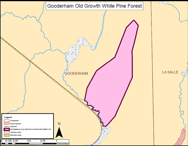
Map 2: Gooderham Old Growth White Pine Forest
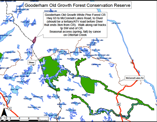
Map 3: Location of Gooderham Old Growth Forest Conservation Reserve
Photos
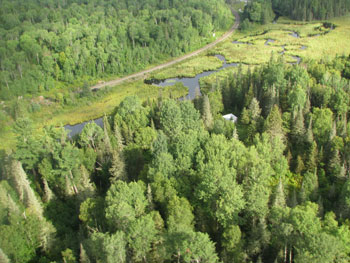
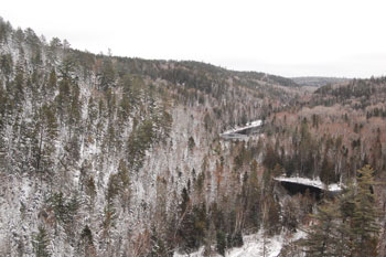
Photo 1: Gooderham Old Growth White Pine Conservation Reserve at southern periphery
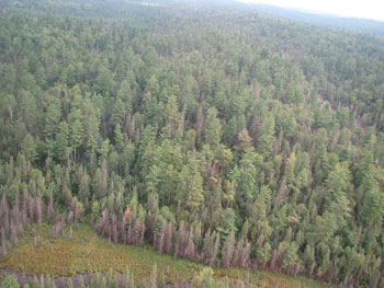
Photo 2: View of small wetland within Gooderham Old Growth White Pine Conservation Reserve
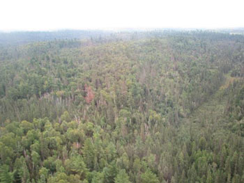
Photo 3: Summer view of northern portion of conservation reserve. (Photo taken by CH Mulligan)
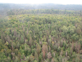
Photo 4: Summer view of northern portion of conservation reserve. (Photo taken by CH Mulligan)
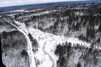
Photo 5: Southern portion of Gooderham Old Growth Forest Conservation Reserve. (Photo taken by J. Brown, MNRF, 22 Nov 2016)
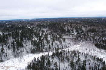
Photo 6: Winter view of Gooderham Old Growth Forest Conservation Reserve. (Photo taken by J. Brown, MNRF, 22 Nov 2016)
Appendix A - Procedural guideline B – Landuses – Test of Compatibility
Public Lands Act Policy PL 3.03.05 (Procedure 3.03.05)
The Conservation Reserve policy provides broad direction with regard to the permitted uses. The policy provides only an indication of the variety of uses that will be considered acceptable in Conservation Reserves. The only caution is that "any new uses, and commercial activities associated with them will be considered on a case by case basis, they must pass a test of compatibility to be acceptable". What does a "test of compatibility" mean?
An examination of this must start from the premise of why an area is set aside – specifically, its representative natural heritage values. Criteria are then identified to guide compatibility considerations. These criteria apply to the long term acceptability of both existing uses and new uses.
-
Conformity to SCI: SCI describe values for which an area has been set aside and the range of appropriate uses that will be permitted in the area. SCI may also speak to the acceptability of other "new" uses currently not occurring in the area.
The first "test" is: "do proposed new land uses and/or commercial activities conform to the direction of the SCI for the Conservation Reserve? Would the new use(s) depart from the spirit of appropriate indicator land uses in the SCI?"
-
Impact Assessment: If the proposed use(s) pass test one it is important to determine their impact on the area before they are approved. This should include the following:
- Impact on natural heritage values: "will the new use(s) impact any natural values in the area? If so, how and to what degree? Is it tolerable?"
- Impact on cultural values: "will the new use(s) impact any historical or archaeological values in the area?"
- Impact on research activities: "will the new use(s) affect any research activities in the area?"
- Impact on current uses: "will the new use(s) have any negative impact on the array of current uses?"
- Impact on area administration: "will the new use(s) increase administrative costs and/or complexity?" (For example, the cost of area monitoring, security and enforcement).
- Impact of accommodating the use outside the Conservation Reserve: "Could the use(s) be accommodated as well or better outside the Conservation Reserve?"
- Impact on socio-economics of the area: "will the use(s) affect the community(ies) surrounding the area in a positive or negative way?" (for example, will the new use make the area less remote thereby affecting a local tourism industry that is dependent on the area’s remoteness for its appeal)?
- Impact on area accessibility: "does the new use(s) give someone exclusive rights to the area or a portion of the area to the exclusion of other existing uses?"
Appendix B - Glossary of terms
Biodiversity: The total variability of life on Earth, including the diversity of genes, species and ecosystems.
Boreal: One of 3 main forest zones in the world. It is located in northern regions and is characterized by the predominance of conifers.
Esker: A knobby, crooked ridge of coarse gravel and sand considered to be deposited by meltwater in crevasses and tunnels near the front of a glacier.
Fen: peatland with water table at or above the surface with very slow water movement through communities via seepage that results in a more mineral, nutrient and oxygen-rich environment than bogs. Generally fens contain peat accumulations greater than 40 cm deep. Sometimes floating mat with sedges, mosses, shrubs and sparse tree layer present. Indicator plants include; Larch (Larix laricina) and Eastern White Cedar (Thuja occidentalis) over Black Spruce (Picea mariana) , Speckled Alder (Alnus incana), Dwarf Birch (Betula pumila) , Bluejoint Grass (Calamagrostis canadensis), assorted sedges, Sweet Gale (Myrica gale) with ericaceous shrubs present – especially in more nutrient poor fens (Harris et al. 1996).
Glaciofluvial: Silt, sand and gravel deposits from meltwaters of a glacier.
IMAR: An integrated, ministry-wide framework for Inventory, Monitoring, Assessment, and Reporting that supports the management of our natural resources in an ecologically sustainable way.
Kame: A knobby hill of irregularly stratified sand and gravel, formed at the edge of a melting glacier.
Moraine: A knobby ridge either of (a) boulder clay built by a thrust of a glacier or of (b) gravel and sand deposited at the edge of a glacier by escaping meltwater.
Poor fen: wetlands generally contain greater amounts of black spruce than cedar and larch as well as ericaceous shrubs and sphagnum or peat mosses.
Vector: A series of distinct points, which makes up a line that defines a portion of a conservation reserve’s boundary. This artificial boundary is created with the use of Geographic Information System (GIS) computer software.
Appendix C - Ontario’s Living Legacy (OLL) Conservation Reserve Permitted Use Table
Table 4: Summary of Permitted Uses in Conservation Reserves within the Planning Area
| Use | Existing Conservation Reserves | New Conservation Reserves in the Planning Area |
|---|---|---|
| Commercial timber harvest, commercial hydro development | Not permitted | Not permitted |
| Mineral exploration and mining | Not permitted | Not permitted |
| Bait fishing, commercial fishing commercial fur harvesting, wild-rice harvesting | Existing use permitted to continue, unless there are significant demonstrated conflicts. New operations can be considered subject to the "Test of Compatibility" | Existing use permitted to continue, unless there are significant demonstrated conflicts. New operations can be considered subject to the "Test of Compatibility" |
| Sport hunting | Permitted | Permitted |
| Sport fishing | Permitted, except in specific fish sanctuaries | Permitted, except in specific fish sanctuaries |
| Seasonal recreation camps "hunt camps" | Existing camps permitted to continue, and may be eligible for enhanced tenure, but not purchases of land (see 6.1.8). | Existing authorized camps, permitted to continue, and may be eligible for enhanced tenure but not purchase of land (see 6.1.8). |
| Commercial Bear Hunting | Existing use permitted to continue. New operations not permitted. | Existing use permitted to continue. New operations not permitted. |
| Tourism facilities (for resource based tourism) and recreational trails | Existing authorized facilities and trails can continue, unless there are significant demonstrated conflicts. No new tourism facilities permitted. New trails can be considered as part of planning for an individual reserve | Existing authorized facilities and trails (motorized and nonmotorized) can continue, unless there are significant demonstrated conflicts. Tourism facilities can apply to upgrade tenure from LUP to lease. New tourism and trails facilities can be considered as part of planning for an individual reserve |
| Land Disposition | Sale of land is not permitted. Renewals of existing leases or land use permits are permitted; requests for transfer of tenure will be considered in the context of a Statement of Conservation Interest (SCI) or a Resource Management Plan (RMP). New leases or land use permits permitted for approval activities | Sale of land is not permitted. Renewals of existing leases or land use permits are permitted; requests for transfer of tenure will be considered in the context of a Statement of Conservation Interest (SCI) or a Resource Management Plan (RMP). New leases or land use permits permitted for approval activities |
| Roads | Existing roads can continue to be used, but new roads for resource extraction will not be permitted | Existing roads can continue to be used, but new roads for resource extraction will not be permitted, |
This table is from the 1999 Ontario’s Living Legacy Land Use Strategy, page 24.
The Public Lands Act, specifically, Conservation Reserve Policy PL 3.03.05 and the Crown Land Use Atlas govern uses and management activities not listed in this permitted use table.
Appendix D - Public Lands Act Policy (3.03.05) Conservation Reserve Permitted Use Table
Indicator sses for Conservation Reserves
Recreation
| Permitted activities Gooderham (C137) | Generic existing | Generic new | (C137) Specific new uses |
|---|---|---|---|
| Sport fishing | Yes | Yes | Yes |
| Sport hunting | Yes | Yes | Yes |
| Food gathering | Yes | Yes | Yes |
| Facility infrastructure | Maybe | Maybe | Maybe |
| Non-trail snowmobiling | Maybe |
Maybe |
Maybe |
| Non-trail ATV use | Maybe |
Maybe |
Maybe |
| Rock climbing/caving | Maybe | Maybe | N/A |
| Canoeing/kayaking | Yes | Yes | Yes |
| Motorized boating | Yes | Yes | Yes |
| Picknicking | Yes | Yes | Yes |
| Camping | Maybe | Maybe | Yes |
| Trails | Yes | Maybe | Maybe |
| Hiking | Yes | Maybe | Maybe |
| Cross country skiing | Yes | Maybe | Maybe |
| Cycling | Yes | Maybe | Maybe |
| Horse riding | Yes | Maybe | Maybe |
| Snowmobiling | Yes | Maybe | Maybe |
Science, education and heritage appreciation
| Permitted activities Gooderham (C137) | Generic existing | Generic new | (C137) Specific new uses |
|---|---|---|---|
| Research | Yes | Yes | Yes |
| General walking | Yes | Yes | Yes |
| Photography and painting | Yes | Yes | Yes |
| Wildlife viewing | Yes | Yes | Yes |
| Outdoor education/interpretation | Yes | Yes | Yes |
| Collecting | No | No | No |
Commercial activities
| Permitted activities Gooderham (C137) | Generic existing | Generic new | (C137) Specific new uses |
|---|---|---|---|
| Food harvesting | Maybe | Maybe | No |
| Fishing | Maybe | Maybe | No |
| Baitfish harvesting | Yes |
Maybe | Yes |
| Trapping | Yes |
Maybe | Yes |
| Trap cabins | Yes | No | No |
| Resort-outpost camp | Yes |
No | No |
| Outfitting-bear management | Yes |
No | No |
| Wild rice harvesting | Yes | Maybe | Maybe |
Resource management
| Permitted activities Gooderham (C137) | Generic existing | Generic new | (C137) Specific new uses |
|---|---|---|---|
| Inventory monitoring | Yes | Yes | Yes |
| Featured species management | Maybe | Maybe | Maybe |
| Natural systems management | Maybe | Maybe | Maybe |
Industrial activities
| Permitted activities Gooderham (C137) | Generic existing | Generic new | (C137) Specific new uses |
|---|---|---|---|
| Timber Harvesting | No | No | No |
| Prospecting | No | No | No |
| Mining | No | No | No |
| Hydro generation | No | No | No |
| Energy transmission corridors | Yes | No | No |
| Communication corridors | Yes | No | No |
| Transport corridors | Yes | No | No |
| Resource roads (MNRF) | Yes | No | No |
Other activities
| Permitted activities Gooderham (C137) | Generic existing | Generic new | (C137) Specific new uses |
|---|---|---|---|
| Land disposition | * |
No | No |
| Hunt camps | Yes |
No | No |
Footnotes
- footnote[1] Back to paragraph New uses will be considered on a case by case basis provided they do not impact the natural heritage values for which the area was established, and must pass a test of compatibility to be acceptable.
- footnote[2] Back to paragraph For retrieval of game only.
- footnote[3] Back to paragraph Transfer requests will be considered in the context of a Statement of Conservation Interest (SCI) or Resource Management Plan (RMP) for each conservation reserve.
- footnote[4] Back to paragraph Existing dispositions will continue, however, as opportunities arise the Ministry will acquire and/or remove them outside of the conservation reserve.