Goulais River Beach Ridges Conservation Reserve Management Statement
This document provides policy direction for the protection, development and management of the Goulais River Beach Ridges Conservation Reserve and its resources.
Statement of Conservation Interest
Ministry of Natural Resources
Sault Ste. Marie District
Algoma Area
February, 2005
Ce document est seulement disponsible en anglais.
Sault ste. Marie District
Ministry of Natural resources
Approval statement
I am pleased to approve this Statement of Conservation Interest (SCI) for Goulais River Beach Ridges Conservation Reserve (C291).
Goulais River Beach Ridges Conservation Reserve was established to protect important wetland communities and provincially significant beach ridge landforms. Regulated on June 7, 2003, this 929 hectare conservation reserve is situated mainly in Fenwick Township with small portions extending into Aweres and Pennefather townships. The site is located approximately 20 kilometres north of the City of Sault Ste. Marie.
Direction for establishing, planning and managing conservation reserves is defined under the Public Lands Act, the Ontario’s Living Legacy Land Use Strategy, and other applicable policies. The specific direction for managing this conservation reserve is in the form of a Statement of Conservation Interest, which defines the area to which the plan applies, provides the purpose for which the conservation reserve has been proposed, and outlines the Ministry of Natural Resources' management intent for the protected area. This SCI has been created with input from program specialists within Sault Ste. Marie District. It will provide both the foundation for the continued monitoring of activities and guidance for the management of the conservation reserve. More detailed direction at this time is not anticipated. However, should significant facility development be considered or complex issues arise requiring additional studies, more detailed management direction in the form of special protection measures, or a detailed Resource Management Plan, will be prepared with full public consultation.
Public and Aboriginal comments were solicited prior to the regulation of this conservation reserve. An additional 15-day review period took place in December, 2004 that provided stakeholders with an opportunity to comment on the draft SCI. Some Aboriginal communities chose not to participate in either of these comment periods. Comments from the SCI review period have been considered in the completion of this document.
The management guidelines outlined in this SCI will be implemented by the Algoma Area Supervisor, and will be reviewed every five years and amended as required by the District Planner, Sault Ste. Marie District, Ministry of Natural Resources.
Written by:
Sheila Walsh,
OLL Planner
Date: February 23, 2005
Submitted by:
Erin Nixon,
District Planner
Date: February 24, 2005
Recommended For Approval by:
Ron Reffle
Algoma Area Supervisor
Date: February 24, 2005
Recommended For Approval by:
Trevor Woods
District Manager,
Sault Ste. Marie
Date: March 2, 2005
Approved by:
Rob Galloway
Regional Director, Northeast Region
Date: April 05, 2005
1.0 Introduction
The following document is a Statement of Conservation Interest (SCI) for Goulais River Beach Ridges Conservation Reserve (C291). The purpose of this SCI is to identify and describe the natural, recreational, and cultural values of Goulais River Beach Ridges Conservation Reserve, and to outline the Ministry of Natural Resources' management intent for this area. Sections 1 to 3 of this document highlight the provincial context in which it was produced, state its goal and objectives, and summarize the planning process for conservation reserves. Sections 4 through 7 are specific to Goulais River Beach Ridges Conservation Reserve and provide background information and management direction for the site. Section 8 outlines the requirements for continued implementation and review of this document.
Management direction specified in this SCI will serve to protect the conservation reserve for the benefit of all Ontario residents. This direction will comply with the land use intent stated in the Ontario’s Living Legacy Land Use Strategy (LUS) (OMNR 1999) and associated policy clarification statements. Additionally, this conservation reserve will be managed under the Public Lands Act (OMNR 1997a), and will comply with all legal requirements as specified under the Environmental Assessment Act (RSO 1990, Chapter E.18).
1.1 Provincial context
Ontario’s network of natural heritage areas has been established to protect and conserve areas representative of the diversity of the natural regions of the province, Including the species, habitats, features, and ecological systems which comprise that natural diversity. Protected natural heritage areas are a key component In the sustainable management of natural resources. They ensure that representative sites within the larger managed landscape are retained in as natural a state as possible.
On July 16, 1999, the Ontario’s Living Legacy Land Use Strategy was released to guide the planning and management of much of Ontario’s Crown lands. Extensive consultation was conducted during the development of the LUS. The objectives of the LUS are to complete Ontario’s system of parks and protected areas; recognize the land use needs of the resource based tourism industry; provide forestry, mining and other resource industries with greater certainty around land and resource use; and, enhance hunting, angling and other Crown land recreational opportunities (OMNR 1999).
The LUS (OMNR 1999) contributes to Ontario’s system of protected natural heritage areas by designating 378 new areas to be protected. These areas are considered to be significant and require protection from incompatible activities in order for their values to endure over time. Goulais River Beach Ridges Conservation Reserve now forms part of Ontario’s network of natural heritage areas. It protects an area dominated by ancient beach ridges and part of a modern river environment of exceptional quality. A very distinctive ridge and swale landform pattern indicates remnants of historical lake shorelines: curvilinear raised beach ridges alternate with intervening wetlands in this area that backs modern-day Goulais Bay.
The Ministry of Natural Resources has established conservation reserves as a tool to protect natural heritage areas on public lands, while permitting most traditional public land uses to continue. These uses include recreational activities, such as hunting and fishing, and the traditional activities of Aboriginal communities, as defined under applicable Aboriginal treaties. Lands designated as conservation reserves in the LUS (OMNR 1999) are removed from the Sustainable Forest License area, and mining and surface rights are withdrawn from staking under the Mining Act (RSO 1990 Chapter M.14).
The LUS (OMNR 1999) and subsequent policy clarification statements outline the general land use policy and management direction for new conservation reserves. Each new conservation reserve will have a planning document, either a SCI or, in more complex situations, a Resource Management Plan that details site-specific management direction.
2.0 Goal and objectives of the SCI
2.1 Goal
The goal of this SCI is to provide the framework and the direction to guide management decisions affecting Goulais River Beach Ridges Conservation Reserve.
2.2 Objectives
The following objectives are identified as the means to achieve the above stated goal:
- To describe the site’s current state of the resource In terms of its values and existing uses and activities.
- To outline the Ministry of Natural Resources' management intent for the protected area.
- To determine the land use compatibility of current land uses, and to develop specific guidelines and prescriptions to manage these uses.
- To create public awareness of the values within this conservation reserve by providing information on the resources it contains and protects, and to support responsible stewardship through partnerships with local stakeholders.
- To identify research, client services, and/or marketing strategies that may contribute to sound long-term management of the conservation reserve.
- To identify the monitoring and/or research necessary to maintain the integrity of protected values.
- To provide direction for the evaluation of proposed new uses or economic ventures through the application of the Test of Compatibility (see Appendix C) and applicable Environmental Assessment Act legislation. This test will evaluate the impact of suggested use(s), either positive or negative, on the protected values of the conservation reserve.
3.0 Management planning
3.1 Planning for a conservation reserve
The planning process for a conservation reserve consists of regulating the site and preparing a site specific management plan. Consultation with the public, Aboriginal communities and industry occur during site identification, boundary finalization, and management planning; however, it is noted that some Aboriginal communities do not wish to participate in these consultation efforts. Regulation of a conservation reserve involves preparing a legal description of site boundaries, removing the site from the Sustainable Forest License area, and withdrawing the site from staking under the Mining Act (RSO 1990 Chapter M.14). Once a conservation reserve is regulated, the level of management planning required to fulfill the protection targets is determined, and either a basic or enhanced SCI or a Resource Management Plan is prepared.
A basic SCI is prepared when there is no deviation from the land use direction provided in the LUS (OMNR 1999) and there are few to no Issues that require resolution. An enhanced SCI is an intermediary document which is used when a site requires more detailed management direction than would be provided by a basic SCI, but does not have issues significant enough to warrant the preparation of a Resource Management Plan (RMP). A RMP is prepared in situations where one or more complex issues have to be addressed, or where there is widespread public interest in a site. Whichever the determination, the plan must be completed within three years of the conservation reserve’s regulation date. The guidelines for the preparation of these documents are provided in Procedural Guidelines A - Resource Management Planning (Conservation Reserves Procedure PL 3.03.05, Public Lands Act) and the Northeastern Region Guidelines on the Planning Process for Conservation Reserves: Statement of Conservation Interest and Resource Management Plan (Thompson 2001).
A SCI is essentially a management plan, which receives its direction from the LUS (OMNR 1999). The purpose of a SCI is to identify the state of the resource in terms of the site’s values and its current land use activities, and to outline the Ministry of Natural Resources' management intent for the conservation reserve. Basic SCI is typically have a 15-day public consultation period, whereas enhanced SCI is and RMPs have a longer consultation period. Upon completion of this public review, the SCI, or RMP, is revised as necessary and approved by the appropriate Regional Director.
Existing permitted uses within conservation reserves may continue, unless they are shown to have a significant negative impact on the values protected by the site. A review/evaluation mechanism is in place to address proposed new permitted uses or land use proposals. The Test of Compatibility (see Appendix C) as outlined in the Public Lands Act Policy PL 3.03.05 (OMNR 1997a), and/or other standard Ministry of Natural Resources environmental screening processes, are used to screen future proposals. Where cultural resources may be impacted, proposals may be screened through Conserving a Future for our Past: Archaeology, Land Use Planning & Development in Ontario, Section 3 (Ministry of Culture 1998).
Public comment may be solicited during a review of any future land use proposals that require new decisions to be made. Appropriate Environmental Assessment Act (RSO 1990, Chapter E.18) requirements and amendment processes will apply to any future proposal and/or any significant change in management direction being considered for a site.
3.2 Planning process for Goulais River Beach Ridges Conservation Reserve
Goulais River Beach Ridges Conservation Reserve was proposed as a conservation reserve in the LUS (OMNR 1999). Consultation has occurred with the public, Aboriginal communities, and industry, although, some Aboriginal communities did not wish to participate in the consultation efforts. The boundary of the site was regulated through an amendment to Ontario Regulation 805/94 of the Public Lands Act on June 7, 2003, by Ontario Regulation 208/03. A copy of public consultation information can be found in Appendix E.
A number of land use interests have been identified within the conservation reserve, including a hydro transmission corridor, a main trail of the provincial snowmobile trail network, and several public roads that traverse the site. These are recognized as pre-existing uses. As no significant conflict is anticipated, it has been determined that a basic Statement of Conservation Interest (SCI) is the appropriate format for delivering the management guidelines for this site. It should be noted that this document addresses only those issues or land use proposals currently known to the District Manager. The direction provided by this SCI, and future management decisions, will work to resolve any potential land use conflicts and to ensure that identified values continue to be adequately protected.
3.2.1 Planning area
The planning area for this SCI consists solely of the regulated boundary for Goulais River Beach Ridges Conservation Reserve (see Figure 1). Adjacent private properties are not subject to direction contained within this SCI. However, to fully protect values within the conservation reserve, efforts should be made to work with adjacent private property owners to ensure that negative impacts to the site’s core values are avoided.
4.0 Background information
4.1 Location and site description
Goulais River Beach Ridges Conservation Reserve is located mainly in Fenwick Township, but small portions also extend into Aweres and Pennefather townships. It can be found approximately 20 km north of the City of Sault Ste. Marie (see Figure 1), west of Highway 17, and extending from the highway to the shore of Goulais Bay on Lake Superior. The site was regulated on June 7, 2003 and is 929 ha in size. Table 1 summarizes the administrative details of the site.
Table 1. Location and administrative details for Goulais River Beach Ridges Conservation Reserve.
| Name | Goulais River Beach Ridges Conservation Reserve (C291) |
|---|---|
| Site Region -Site District (Hills 1959) | 4E-2 Batchewana |
| Eco Region - Eco District (Crins and Uhlig 2000) | SE-13 |
| OMNR Administrative Region/District/Area | Northeast Region/Sault Ste. Marie District/Algoma Area |
| UTM co-ordinates | 700409E, 5176312 N (Zone 16 NAD 83) |
| OBM Numbers | 2016690051700,201670051700 |
| Topographical Map Number/Name | 41K/9 Sault Ste. Marie |
| Nearest City/Town | Approximately 20 km north of the City of Sault Ste. Marie |
| Township(s) | Fenwick,Pennefather,Aweres |
| Area | 929 ha |
| Forest Management Unit | Algoma Forest |
| Wildlife Management Unit | 36 |
| Regulated | June 7, 2003 |
| SCI Completed | February, 2005 |
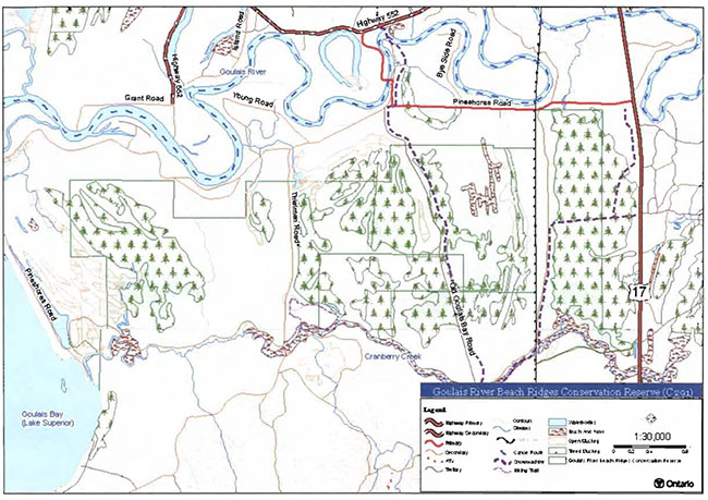
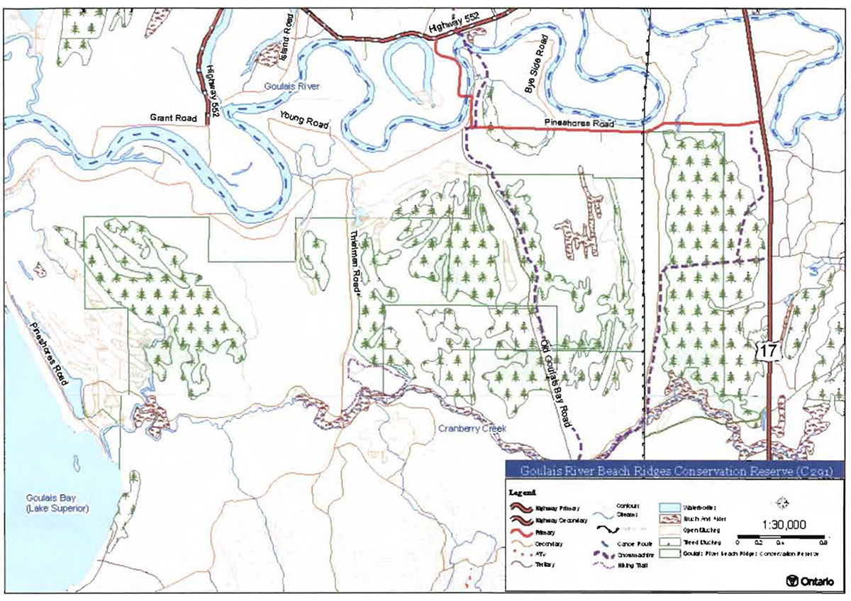
Whenever possible, recognizable natural and cultural features, such as creeks, shorelines or old roads, have been used to delineate conservation reserve boundaries to facilitate on-theground identification. Because this conservation reserve is completely surrounded by patented properties, its boundary is almost entirely defined by adjacent property lines (ie. straight lines). The northern boundary is roughly parallel to Pineshores Road, but backs properties along that road. The western boundary backs properties along the shore of Goulais Bay on Lake Superior. The east boundary is defined by the back lot lines of properties along Highway 17; this boundary also coincides with the boundary between Fenwick and Vankoughnet townships. Most of the southern boundary is located north of Cranberry Creek, and is defined by property lines. In the site’s southeast corner, the boundary follows an old road from the hydro corridor eastward to the limit of Highway 17. In the southwest corner, the site boundary follows along the western shore of Cranberry Creek, and the water’s edge of a backshore lagoon. A separate block of Crown land along Old Goulais Bay Road has been included in the conservation reserve; it is situated in the southeastern portion of the site (see Map 1, Appendix A).
Figure 1. Location of Goulais River Beach Ridges Conservation Reserve.
Goulais River Beach Ridges Conservation Reserve is relatively accessible. The southeast corner is adjacent to Highway 17. The north side of the site is bounded by private property along Pineshores Road, except where the powerlines cross Pineshores Road. Access to the eastern end of the site can be gained by following a small road that runs underneath and adjacent to the powerlines. Midway through the conservation reserve, Old Goulais Bay Road provides vehicular access through the center of the site; however, this road is accessible only by snowmachine during the winter months. Toward the western end of the conservation reserve, year round access is provided via Thielman Road. Winter access is available via snowmachine trails through the site in its eastern half: one trail follows Old Goulais Bay Road through the site, and another trail follows the powerline road for a short distance, then passes beyond the site through its eastern boundary. Cranberry Creek provides limited access from Goulais Bay into the western end of the site.
Goulais River Beach Ridges Conservation Reserve is located within Hills' (1959) Site District1 4E-2 (Batchewana). More recently, this ecological unit was reassigned to Eco District SE-13 (Crins and Uhlig 2000). According to either classification, the ecological unit stretches from Goulais River northward along the eastern shore of Lake Superior to the Montreal River area, and inland for about 60 km. It is characterized as a broken area of gently sloping uplands and moderate broad valleys of sand and silt. Maple and yellow birch are common on the upper slopes. Valleys occur frequently, and the depth of bedrock is extremely variable.
The conservation reserve captures part of an outwash valley plain that was created over centuries by the flow of the Goulais River. The site’s ridge and swale landform pattern is an excellent demonstration of shoreline wave actions and shifting river courses. According to Burkhardt et.al. (2004), Goulais River Beach Ridges Conservation Reserve is characterized by a low to moderate diversity of vegetation and landform conditions. This assessment is based on relatively uniform landform conditions in combination with wetland-dominated vegetation communities. Diversity is rated higher when the individual wetland types are considered in the assessment. Photos of the conservation reserve can be found in Appendix B.
4.2 History of the site
The area now protected within Goulais River Beach Ridges Conservation Reserve has a history dominated by recreational uses. The site’s poor tree growth, resulting from its wet, organic conditions, has restricted the site’s productivity for commercial timber. The surrounding and adjacent lands are patented, being occupied by year-round and seasonal residents, many of whom have enjoyed recreational pursuits on the Crown lands adjacent to their property. In addition to recreational activities, the Crown lands within and/or adjacent to the conservation reserve have been used for industrial activities, such as the construction of a hydro transmission line, and a waste disposal site.
Just outside the north boundary of the conservation reserve, west of the powerlines, the Ministry of Natural Resources operated a waste disposal site from 1972 to 1992 to collect domestic and commercial waste from the area’s residents and businesses. In 1992, a contractor began operating the disposal site on behalf of the Ministry of Natural Resources. All operations continued to be monitored by the provincial ministries of Natural Resources and Environment. In 1999, the waste disposal site was ordered closed because of concerns about the movement of groundwater through the site. The disposal site is now securely gated and the area has been capped with clay soils. On-site groundwater quality continues to be monitored.
In the early 1930s, Great Lakes Power Ltd. established the transmission corridor that now runs through the eastern half of the conservation reserve. The right-of-way is 200 ft wide and currently holds three separate, high voltage transmission lines. As of 2005, the company was preparing to upgrade these transmission lines, reducing the number of lines to two, while increasing the efficiency of conveyance.
Old Goulais Bay Road was the driving route from Sault Ste. Marie to the Goulais Bay area until the mid-1960s, when construction of the current Highway 17 was completed. Road access to the area resulted in development pressures as the public sought to utilize the area’s considerable recreational potential. Most development occurred along the shoreline of Goulais Bay and along the river. Not surprisingly, the high watertable and organic substrates dominating the conservation reserve did not appeal to those building camps and houses. It is because of these site characteristics that the Goulais River Beach Ridges Conservation Reserve has remained in relatively undisturbed condition, despite the development pressures immediately adjacent to its boundaries.
4.3 Inventories
Below, in Table 2,the current status of natural heritage inventories is summarized for Goulais River Beach Ridges Conservation Reserve. Recommendations for future inventory needs are located in Table 3, Section 7.2.
Table 2. Existing inventory and survey information for Goulats River Beach Ridges Conservation Reserve.
| Type of Inventory | Inventory Method | Date(s) of Inventory | Report |
|---|---|---|---|
| Life Science | Aerial reconnaissance | September 8, 2003 | Burkhardt, B., King, L. and Longyear, S. 2004. Goulais River Beach Ridges Conservation Reserve (C291), Life Science Checksheet- Step 2 (Preliminary). Unpublished Information. Ontario Ministry of Natural Resources. |
| Earth Science | Aerial reconnaissance | September 8, 2003 | Kristjansson, R. Earth Science Inventory Checklist for Goulais River Beach Ridges Conservation Reserve. (In prep.) |
| Recreation | Ground and aerial reconnaissance | Ground: Nov. 2002, Jan./Aug. 2003, June 2004 Aerial: Sept. 8, 2003 |
Walsh, S., 2004. Goulais River Beach Ridges Conservation Reserve (C291) - Recreation Resource Inventory Report. Unpublished Information. Ontario Ministry of Natural Resources. |
5.0 State of the resource
5.1 Key values
Key values are those values that make this site unique and have led to its designation as a conservation reserve. Their protection is paramount. The key values found within Goulais River Beach Ridges Conservation Reserve include the following:
- Ancient beach ridge landforms (provincially significant)
- Wetland vegetation communities (unevaluated, but potentially provincially significant)
- Cranberry Creek
Additional values as listed in Section 5.2 through Section 5.6 are also important. Descriptions in this section (5.1) are not necessarily complete. If new values, key or otherwise, are identified, they will be added to this section. If any new value is considered to be significant, management guidelines may be modified, if required, to ensure its protection.
5.2 Earth sciences values
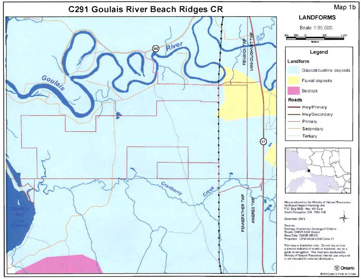
Goulais River Beach Ridges Conservation Reserve is located in a broad geologic area known as the Abitibi Uplands, which is characterized by an undulating, rocky landscape of uplands and valleys with an abundance of lakes, folds and faults. The Abitibi Uplands are largely underlain by gneiss and granite rocks. This bedrock geology is covered generally by stony sandy tills with frequent flats and ridges of water-laid sand (Crins 1996). The conservation reserve is underlain by undifferentiated sedimentary rocks (probably sandstone) of the Jacobsville Group, Upper Keweenawan Supergroup, Southern Province, Precambrian Shield (Kristjansson pers.comm.). This same kind of rock is exposed at lie Parislenne Conservation Reserve, located in Lake Superior off the point at Goulais Bay.
Backing Goulais Bay on Lake Superior is a distinct and extensive valley plain of the Goulais River. The plain is bounded to the north, east and south by high bedrock hills, and consists of lacustrine sand, silt and clay materials as well as widespread organic deposits. The Goulais River meanders back and forth across the plain, eventually emptying into the bay at the Goulais River delta. Goulais River Beach Ridges Conservation Reserve is situated on this plain, south of the river’s current location. The site’s unique landform characteristics are a result of hydrological actions along the shorelines of both the river and Lake Superior thousands of years ago.
According to Kristjansson ( pers. comm.), the conservation reserve is dominated by lacustrine and glaciolacustrine deposits with a thin veneer of organic material. A small portion of the site, in its northeast corner, is dominated by fluvial deposits (Burkhardt et.al. 2004). Kristjansson suggests that there may be two depositional periods represented within the site: glaciolacustrine deposits occur in the eastern part and post-glacial lacustrine deposits occur in the western portion. The beach ridges in the eastern part of the conservation reserve likely developed through the shoreline actions of glacial lakes, while the western part of the site has developed since the glacial period through the shoreline actions of Lake Superior and the Goulais River watercourse. The features are somewhat less distinct in the western parts of the conservation reserve, suggesting that they have not been in place as long as those in the eastern part of the site.
The most distinctive landform pattern on the plain is a series of ancient beach ridges which are oriented in a north-south direction. The beach ridges exist in a recurring curvilinear pattern, and are raised slightly (1-2 m) above the surrounding landscape. Organic deposits have developed in the intervening depressions. These organic deposits are relatively shallow (approx. 50 cm), and mineral substrate, comprised of fine textured lacustrine silts and sands,is typically encountered within 2 m of the surface.
In the east half of the site, the ridges are reported to have developed as storm beaches primarily under lacustrine influence (i.e. away from the mouth of the Goulais River). In the west, the beach ridges were formed from recurved spits that developed as the river emptied into Goulais Bay, under both lacustrine and fluvial processes. Much as it is today, the river flowed along the bay’s shoreline. Sand spits developed that would eventually close off the river channel, thus creating a lagoon behind the shoreline. The earlier lagoons have since filled in with organic materials creating the ridge and swale pattern. (Burkhardt et.al. 2004; Kristjansson pers.comm.)
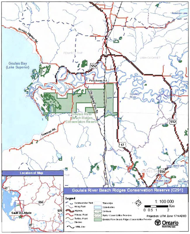
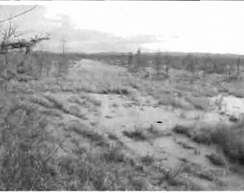
Figure 2. Aerial photo (1994) showing beach ridges west of powerlines. The Goulais River snakes across the top of the photo. Goulais Bay is off the left side of the photo.
In addition to the ridge and swale beach ridge feature, there is an extensive organic deposit located between the powerline and Highway 17. This wetland area is thought to have deeper organic deposits than areas west of the powerline,in part because it is older than the wetlands in the western portions of the site, and has had a longer period of organic accumulation. This area has been recognized as a significant peat deposit by the Ontario Geological Survey (Graham and Bruce 1979).
Kristjansson (in prep.) describes in more detail the surficial geology of the site in the Earth Science Inventory Checklist.
5.3 Life sciences values
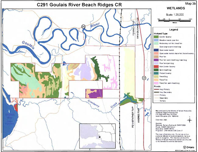
Goulais River Beach Ridges Conservation Reserve was identified primarily to protect unique earth science values, but the site also protects interesting and potentially provincially significant life science features. The patterns of landforms found within the site have strongly influenced the development of vegetation communities. The site’s lowlands and wetland areas typically support shrubs, grassy hummocks and sphagnum moss. Trees are absent or very sparsely scattered and stunted. In contrast, the upland site conditions tend to be drier, with greater nutrient availability, so vegetation under these conditions is more often forested with trees and a range of shrubs, herbs and moss species.
Wetlands are the dominant condition within the conservation reserve and have been classified according to Harris et.al. (1996) into several different types,including marshes (areas of standing or slow moving water, with emergent plant cover), fens (peatlands with water at or above the surface; moving water allows nutrients to be transported into site from adjacent uplands), bogs (peatlands with water at or near surface; nutrients provided to site by atmospheric deposition), and swamps (wetlands with peat or mineral substrate; can support trees, as well as shrubs, graminoids, herbs, mosses; Burkhardt et.al. 2004).
West of Thielman Road, the site’s wetlands have been identified primarily as treed fen and treed bog. The black spruce (Picea mariana (Mill.) BSP.) and tamarack (Larix laricina (Du Roi) K. Koch) that are the dominant tree species in this area are stunted and widely scattered. An open water marsh has also been identified close to the western boundary (Burkhardt et.al. 2004). Immediately adjacent to Thielman Road, wetland conditions give way to a well stocked, white birch-dominated mixed stand that has developed on a slightly raised, and therefore drier, part of the site.
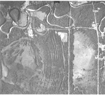
In the site’s eastern half, there is a greater mix of wetland and upland conditions (Burkhardt et.al. 2004). From Thielman Road to Old Goulais Bay Road, open bog is the most common wetland type. Between Old Goulais Bay Road and the powerlines, dominant wetlands have been identified as semi-treed bogs and treed fens. nterspersed in these wetland conditions, upland forests have developed on the raised beach ridges. Black spruce is the dominant conifer species In these stands, although it is usually in combination with white birch (Betula papyrifera Marsh.), trembling aspen (Populus tremuloides Michx.), balsam fir (Abies balsamea L.) and/or white cedar (Thuja occidentalis L.).
Figure 3. Open bog east of powerlines.
(Photo by S. Walsh; September 2003)
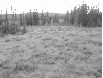
Figure 4. Mixed forest on beach ridge.
(Photo by M. Hall; November 2002)
Insufficient field-based inventories have been completed in this site to adequately describe the life science values. Although a wetland evaluation has not been conducted for the wetland complex that falls within this conservation reserve, it is expected that it would be identified as provincially significant (Dupont pers. comm.). A number of rare plant species have been recorded in the vicinity of the conservation reserve (Natural Heritage Information Centre 2004), but their occurrence within the site boundary still needs to be confirmed. Their existence within the evaluated wetland would likely support its designation as provincially significant.
Stocking2 in the site’s forested areas is typically less than 70%, and the majority of the site is stocked in the range of 41 to 60% (Burkhardt et.al. 2004). The white birch mixed stand along Thielman Road is recorded as 100% stocked. As stocking is calculated for stands with trees in the canopy, the majority of the wetlands in the conservation reserve have no recorded stocking.
Forest stand ages range up to approximately 150 years. Most of the stands are in the range of 60 to 89 years; a limited number of stands range from 120 to 159 years. These older stands may fit the criteria for candidate old-growth in black spruce (Uhlig et.al. 2001). Similar to stocking estimates, non-treed, wetland areas within the conservation reserve lack recorded ages because they are not included in standard forest resource inventories.
Fish and wildlife values have also been documented within this conservation reserve. The expansive wetland areas provide ideal moose (Alces alces) habitat. Moose are frequently observed within and adjacent to the conservation reserve and have been a hazard to highway traffic as they move between the wetlands in the conservation reserve to areas east of Highway 17. Black bear (Ursus americanus) have also been observed in and near the conservation reserve, particularly along the roadways that traverse the site.
The Goulais Bay area has long been identified as an important staging area for resident and migrating waterfowl. Thousands of ducks and geese, as well as swans have been observed in the delta at the mouth of the Goulais River. It is presumed that these birds also rest and feed within the conservation reserve where there is little disturbance from human activities. The western part of the conservation reserve falls within a sampling block of Ontario’s Breeding Bird Atlas (OBBA: www.birdsontario.org) program. Some sample points for the OBBA's Block 16FS97 (Region 35), fall within the western part of the conservation reserve. Evidence of breeding birds has been recorded, primarily along the roadways in the area. An abundance of songbird species have been identified, including warblers, sparrows, finches, and woodpeckers. Bald eagles (Haliaeetus leucocephalus) and osprey (Pandion haliaetus) have also been observed in the area surrounding the conservation reserve.
Sightings of sandhill cranes (Grus canadensis) have also been reported in the area. Although no nest sites have been confirmed within the protected area, there are several nest sites immediately adjacent to the site. The open characteristics of the site’s wetlands provide ideal conditions for these large birds.
Cranberry Creek is recognized as brook (Salvelinus fontinalis) and rainbow trout (Oncorhynchus mykiss) habitat. Beaver (Castor canadensis) are also active along this creek and their dams have been known to impede human traffic along the watercourse.
5.4 Recreational values
Goulais River Beach Ridges Conservation Reserve currently supports a variety of wellestablished recreational pursuits, and offers potential opportunities for a number of others. The main recreational features have been identified as trails and roads that provide access into and through the site, and interesting landform and vegetation features. These recreational features in turn support activities such as snowmobiling and ATVing, hunting, and nature observation (Walsh 2004).
Figure 5. Snowmobile trail at powerline road looking east across open bog, toward Hwy 17.
(Photo by M. Hall; November 2002)
The most popular recreational activity within the conservation reserve is snowmobiling. A portion of the Ontario Federation of Figure 5. Snowmobile trail at powerline road looking east across open bog, toward Hwy 17. (Photoby M. Hall; November 2002) Snowmobile Clubs (OFSC) trail system passes through the conservation reserve, in the eastern half of the site. The trails follow existing linear features including Old Goulais Bay Road, the hydro corridor, and the powerline road. A spur trail also cuts across the wetland, east of the hydro corridor, connecting the main trail to Highway 17 and providing snowmobile access to commercial facilities at the corner of Highway 17 and Pineshores Road. The majority of snowmobile traffic in the site is just passing through en route to other destinations.
Other roads also provide access to the interior of the conservation reserve, and at least two abandoned roads are mapped within and/or adjacent to the conservation reserve. The condition of the abandoned roads has not been determined, but it has been reported that they are used by local traffic as informal, recreational trails for snowmobiling and/or ATVs. Off-trail ATV use was evident during an aerial reconnaissance flight in September 2003, during which ATV tracks were observed passing through some of the wetland areas of the conservation reserve. While tire ruts were clearly visible, it did not appear that these were frequently used routes.
Big-game and bird hunting are other common recreational activities within the site. Moose are frequent occupants of the site’s wetland areas. The roads traversing the site significantly enhance access into the moose habitat. Evidence of moose hunting success was discovered in the form of hide remains abandoned on one of the roads passing through the site. Roadways also facilitate game-bird hunting.
Wildlife viewing, botanizing, and general nature appreciation are activities that have tremendous potential in this site. Because it is readily accessible, and because roadways traverse the site at fairly regular intervals, there is reasonable opportunity to enter the site at a number of locations, and in a variety of habitat conditions. Birdwatchers enjoy the mix of open, forested, and edge habitats; botanists experience a variety of wetland types; and geography enthusiasts have the opportunity to observe, at ground level, the distinctive beach ridges.
Other recreational activities that have been reported within Goulais Beach Ridges Conservation Reserve include hiking, canoeing, snowshoeing, and dogsledding. More detailed analysis of the recreational values associated with Rawhide Lake Conservation Reserve is presented in Recreational Inventory Report for Goulais River Beach Ridges Conservation Reserve (Walsh 2004).
5.5 Cultural values
This site falls within the Robinson-Huron Treaty area. To date, there are no known cultural heritage values within the conservation reserve. The site may have archeological potential due to the presence of beach ridges which indicate ancient shorelines and river routes along which historic travel or habitation may have occurred.
5.6 Research values
There are three recorded research plots within this conservation reserve. Two plots located on the south side of Thielman Road are Forest Ecosystem Classification (FEC) sampling plots. The third plot, located just east of the powerlines, was established during the development of a regional wetland classification system. Sault College forestry students have occasionally practiced forest mensuration techniques within the conservation reserve since the 1980s.
5.7 Site condition
The condition of this conservation reserve is relatively undisturbed compared to surrounding lands. Disturbance has been rated low (Burkhardt et.al. 2004) because it is estimated that less than 10% of the site has been affected by human or natural activities in recent years. All existing disturbances are human-made, but tend to be located along the corridors that pass through the site, including roads, powerlines and snowmobile trails. With most activities confined to these linear corridors, vast areas of the site are relatively undisturbed. Substantial changes to the natural environment have occurred within the corridors, during their construction, as well as resulting from ongoing maintenance activities. The primary effect is removal and/or control of vegetation by mechanical and/or chemical techniques. Considerable amounts of garbage have accumulated along some of the corridors. The powerline road seems to be particularly susceptible to dumping of household garbage, including couches, refrigerators, snowmobile parts, etc. This is likely a result of the road’s relatively isolated location and low traffic volumes.
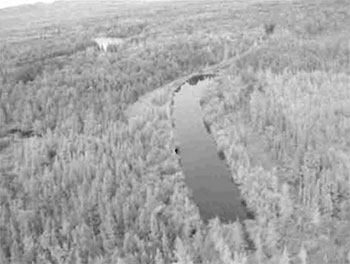
Another human-made disturbance is a pond that was dredged out by an adjacent landowner in an attempt to develop waterfowl and fish habitat. The pond is located near the north boundary of the conservation reserve, just west of Thielman Road. It is visible from the air, where its straight shorelines betray its artificial origins. The north end of the pond was initially formed by piling dredged substrate across the outlet creek. This has since been the location of beaver dam construction. The natural drainage from this pond flows northward to the Goulais River.
Although not formally assessed, activities on adjacent private properties may also be affecting this conservation reserve. In some locations, timber harvesting has been carried out immediately adjacent to the site’s boundaries. The removal of trees outside of the site may contribute to some blowdown of trees from within the site,along its boundary.
Figure 6. Garbage dumped along powerline road.
(Photo by S. Walsh; May 2004)
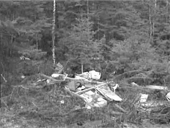
Figure 7. Man-made pond west of Thielman Road.
(Photo by S. Walsh; September 2003)
6.0 Management guidelines
All management guidelines in this SCI are based on direction contained in the LUS (OMNR 1999) and associated policy clarification statements. The management guidelines outlined in this section are specific to Goulais River Beach Ridges Conservation Reserve and are intended to protect the site’s unique values. The guidelines in this document may be subject to change and may be amended as necessary. If a conflict between management guidelines exists, the conservation reserve will be managed to protect the integrity of its natural values, while permitting compatible land use activities (Public Lands Act, PL 3.03.05).
Proposed new uses and/or development, as well as research and education activities, will be reviewed on a case-by-case basis. Before new proposals can be permitted, the Test of Compatibility (see Appendix C) must be passed as well as consideration of cultural values according to Conserving a Future for our Past: Archaeology, Land Use Planning & Development in Ontario, Section 3 (Ministry of Culture 1998). In addition, all new proposals are subject to applicable Environmental Assessment Act (RSO 1990, Chapter E.18) requirements.
The following management strategies have been devised to achieve the goal and objectives of the SCI for Goulais River Beach Ridges Conservation Reserve. A summary table of the management guidelines for this site can be found in Appendix D. For the most up-to-date version of this summary table, please refer to the Crown Land Use Policy Atlas, located on the Internet at /page/crown-land-use-policy-atlas/, or contact the local Ministry of Natural Resources office. The Crown Land Use Policy Atlas is a consolidation of existing local land use policies for Crown lands within the OLL planning area, an area that covers 45% of the province, extending from Lake Simcoe in the south to the Albany River in the north.
6.1 Industrial activities
6.1.1 Commercial timber harvest
The area contained within this conservation reserve (929 ha) has been withdrawn from the Algoma Sustainable Forest License area and no commercial timber harvesting will be permitted. Please refer to Section 6.4.3 for information regarding non-commercial wood harvesting.
6.1.2 Mining and exploration
Mining and surface rights within the conservation reserve’s boundaries have been withdrawn from staking under the Mining Act (R.S.O 1990 Chapter M.14). Mineral exploration is not permitted within the conservation reserve.
6.1.3 Extraction of peat, soil, aggregate and other material
Extraction of peat, soil, aggregate and other material is not permitted.
6.1.4 Energy generation
New hydropower developments are not permitted within Goulais River Beach Ridges Conservation Reserve. Wind power developments are prohibited under the Public Lands Act, Procedure PL 4.10.04 "Wind Power Development on Crown Land" (OMNR 2004b) See Section 6.2.2 for details regarding the hydro transmission corridor that passes through this site.
6.2 Existing and proposed development
6.2.1 Transportation corridors
6.2.1.1 Roads
According to the LUS (OMNR 1999), new roads for resource extraction will not be permitted except for those identified in Forest Management Plans prior to March 31, 1999. No new or existing roads for resource extraction were identified within the conservation reserve by the forest companies. Most of the existing roads border the site or pass through it (i.e. Pineshores Road; Old Goulais Bay Road; Thielman Road) are administered by the local roads board. The powerline road is a small road that was built and for use by the power company for access to transmission lines. These existing roads can continue to be used, including upgrades and maintenance.
6.2.1.2 Trails
Snowmobile trails that form part of the provincial network designated by the Ontario Federation of Snowmobile Clubs (OFSC), pass through the conservation reserve in two locations. The trail from Sault Ste. Marie to Goulais River passes through the eastern half of the site in a north-south direction. Part of the trail follows Old Goulais Bay Road through the site. A second trail follows a short distance along the powerline road, then passes out of the site along its eastern boundary, providing snowmobile access to commercial establishments on the highway.
Other informal trails are known to exist within the conservation reserve, although the exact locations have not all been confirmed. These trails have been created by adjacent landowners pursuing activities on Crown lands now regulated within the conservation reserve. One such trail was discovered during winter reconnaissance: a short loop trail off the east side of Thielman Road, complete with directional signs. The amount of clearing is minimal, indicating this may be a snowshoe trail that is not commonly used. Other trails have been reported in the western half of the conservation reserve: two that follow along ridges and another that passes through the wetland and connects with Cranberry Creek. The latter trail is used primarily in winter by snowmobilers and skiers. The other two trails are similarly used during the winter, but because they are on higher and drier ground, they have also been used throughout the year by ATVs, and hikers.
All existing trails documented above are permitted to continue. However, should the impact of activities on these trails degrade the landscape, the Ministry of Natural Resources will reevaluate these permitted uses and decide upon a new strategy for this site. Any proposed new trails will be subject to the Test of Compatibility (see Appendix C) and applicable Ministry of Natural Resources' policies and procedures. Trail development in low-lying areas and wetlands will be discouraged. All new and existing trail heads and trail routes must be recorded using new technologies (i.e. global positioning systems) to ensure an accurate record of the location of the feature. This location information must be provided to the Sault Ste. Marie District, Ministry of Natural Resources.
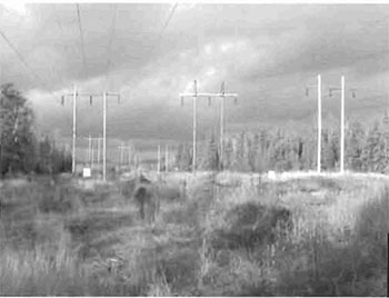
6.2.2 Other corridor development/maintenance
The main northern transmission line for Great Lakes Power Ltd./Brascan passes through the east end of the site in a north-south direction. The right-of-way is 200-ft wide and currently contains three transmission lines on wooden poles. The number of lines is expected to be reduced to two in the near future. Maintenance of and upgrades to this transmission corridor are permitted to continue, subject to regulations set out in relevant Acts (ie. Environmental Assessment Act, Environmental Protection Act, Pesticides Act, Electricity Act). All activities will be carried out with due regard for the values being protected within this conservation reserve.
No other communication or non-road corridors are located within this conservation reserve. New corridor developments will be actively discouraged. Additionally, proposals for new corridors will be subject to the Test of Compatibility (see Appendix C) and applicable Ministry of Natural Resources' policies and procedures.
Figure 8. Three transmission lines in hydro corridor.
(Photo by S. Walsh; November 2004)
6.2.3 Natural heritage appreciation facilities/recreational structures
There are currently no existing authorized natural heritage appreciation facilities or recreational structures (ie. boardwalks, bird viewing platforms, kiosks, ski shelters, or interpretive signs). New natural heritage appreciation facilities and recreation structures are permitted, subject to the Test of Compatibility (see Appendix C) and applicable Ministry of Natural Resources' policies and procedures.
6.2.4 Land disposition
Sale of Crown lands is not permitted, except for those situations described in the policy clarification tables (OMNR 2000).
Presently, one land use permit (LUP) has been issued within this conservation reserve, for the hydro transmission corridor. New LUPs or leases may be issued for approved public uses (i.e. not for private recreation camps), subject to the Test of Compatibility (see Appendix C) and applicable Ministry of Natural Resources' policies and procedures. These leases/permits will not be sold but may be eligible for enhanced tenure or transfer.
Enhanced tenure is defined as anything beyond the term and form of current tenure. All requests for transfer or enhanced tenure will be subject to the following screening criteria:
- Is the transfer or enhanced tenure consistent with the conservation reserve’s land use intent, which is the protection and enhancement of the site’s natural, recreational and cultural values?
- Is it consistent with the land disposition policies outlined in the District Land Use Guidelines, the Crown Land Use Policy Atlas, this SCI and any other applicable document?
- Does it adversely affect the values as identified in Section 5.0, and/or conflict with other uses?
- Is land needed by the Crown to protect significant natural or recreational values outlined in this SCI?
- Does the transfer or enhanced tenure clash with traditional Aboriginal uses, land claims or agreements?
- Are all rents, taxes, fees, rates or charges paid up for the existing LUP or lease?
6.3 Commercial activities
6.3.1 Commercial bait harvesting
Fenwick, Pennefather and Aweres townships, which encompass the conservation reserve, have all been allocated to commercial bait harvesters. New operations can be considered subject to the Test of Compatibility (see Appendix C) and applicable Ministry of Natural Resources' policies and procedures.
Under Public Lands Act PL 3.03.08 "Buildings for Bait Harvesting Management" (OMNR 2002), cabins for the purposes of bait harvesting may be constructed on Crown land. However, such buildings should be avoided within this conservation reserve wherever possible and be established on Crown land outside of the protected area.
6.3.2 Commercial fishing
There are currently no commercial fisheries. Although not likely applicable in this conservation reserve, new operations may be considered subject to the Test of Compatibility (see Appendix C) and applicable Ministry of Natural Resources' policies and procedures.
6.3.3 Commercial fur trapping
Goulais River Beach Ridges Conservation Reserve Is located in an area that is designated as a private land trapping zone. Trapping is permitted within the conservation reserve following Sault Ste. Marie District’s established procedures for assigning Crown land parcels in private land trapping zones.
The establishment of new trapline trails will be considered following the procedure and criteria for new trails as outlined in Section 6.2.1.2. No trap cabins currently exist within Goulais River Beach Ridges Conservation Reserve. The establishment of new trap cabins will not be permitted.
6.3.4 Bear Management Areas
The conservation reserve is situated in an area dominated by patented land and residential properties. For this reason, the area has not and will not be allocated as a bear management area (BMA). New BMA operations will not be considered within this conservation reserve. See Section 6.4.4 for direction on hunting activities within the conservation reserve.
6.3.5 Commercial food collection
There are currently no existing commercial food harvesting ventures. Any new ventures requiring permits from the Ministry of Natural Resources will be subject to the Test of Compatibility (see Appendix C) and applicable Ministry of Natural Resources' policies and procedures.
6.3.6 Commercial non-timber forest products
Commercial harvesting of non-timber forest products is not consistent with the intent of conservation reserves and will not be permitted.
6.3.7 Outpost camps/main base lodges
There are currently no authorized commercial outpost camps or main base lodges in the conservation reserve. Although new outpost camps and main base lodges may be considered in conservation reserves, such developments will not be permitted within this site because of the negative impacts on wetland and beach ridge features that would be expected to occur.
6.4 Non-commercial activities
6.4.1 Nature appreciation/recreation activities
Off-trail hiking, cross-country skiing, snowshoeing, and other non-motorized activities will be permitted within this conservation reserve. However, should the impact of these activities degrade the landscape, the Ministry of Natural Resources will re-evaluate these permitted uses and decide upon a new strategy for this site. New trails to support these activities may be considered. Please refer to Section 6.2.1.2 for more details related to trail development.
6.4.2 Camping
There are no maintained campsites or campgrounds within this conservation reserve. Crown land camping policies apply, unless significant adverse effects on protected values necessitate further planning and management for this activity. Existing campsites should be used wherever possible and campers should avoid sensitive areas.
6.4.3 Non-commercial consumptive resource use
In conservation reserves, cutting of trees for non-commercial purposes may be authorized via a permit issued by the local Ministry of Natural Resources' office, subject to review and determination of the impact that such cutting would have on the values identified in Section 5.0. Such permits are intended only for leaseholders or land use permit holders within the conservation reserve who do not have road access to their property and have no alternate wood source outside of the conservation reserve. This permit is intended to cover fuelwood, dock stringers, and other occasional small scale uses. Because there are no private lease or LUP holders within the conservation reserve, permits for tree cutting will not be issued.
Non-commercial harvesting of non-timber forest products such as berries and mushrooms can occur provided the values of the site, identified in Section 5.0, are not jeopardized.
6.4.4 Hunting and fishing
Hunting and fishing are traditional activities within this conservation reserve. In conjunction with current hunting and/or fishing regulations and conservation reserve policy, both hunting and recreational fishing are permitted to continue.
6.4.5 ATV and snowmobile use
The local trail network of Ontario Federation of Snowmobile Clubs (OFSC) passes through the conservation reserve at two locations in the eastern portion of the site. Use of this existing trail, for winter snowmobile traffic, is permitted to continue. Use of ATVs on the snowmobile trail during non-winter months is not permitted in wetland areas in order to minimize impacts on the organic terrain (ie. soil compaction, rutting and altered drainage). Off-trail use of ATVs and snowmobiles is not permitted within the conservation reserve, except for the direct retrieval of big game by hunters. Such uses will only be permitted provided the protection of the site’s values is not compromised. Should the impact of off-trail ATV or snowmobile use degrade the landscape, the Ministry of Natural Resources will re-evaluate these permitted uses and determine a new strategy.
6.5 Resource management activities
Resource management activities refer to those tools used to protect and enhance the values of this conservation reserve. Some management activities may require the use of intrusive techniques. Under normal circumstances, some of these techniques would not be permitted to occur in the conservation reserve; however, if they are found to be necessary, they may be applied under controlled conditions, to achieve a desired result. Infrastructure such as roads, trails and buildings may need to be constructed to support activities such as prescribed burns, forest regeneration, wildfire control, and insect and disease control. Activities described in this section will be deemed acceptable if the ultimate outcome is in compliance with the management intent for this conservation reserve.
6.5.1 Insect and disease control
This conservation reserve will be maintained in as natural a state as possible. Insect and disease control measures should only be considered if the identified values are significantly threatened.
6.5.2 Fire management
The Ministry of Natural Resources recognizes fire as an essential process fundamental to the ecological integrity of conservation reserves. In accordance with existing conservation reserve policy and the Forest Fire Management Strategy for Ontario (OMNR 2004c), forest fire protection will be carried out as on surrounding lands.
Whenever feasible, the Ministry of Natural Resources' fire program will endeavor to use "light on the land" techniques, which do not unduly disturb the landscape, in this conservation reserve. Examples of light on the land techniques may include limiting the use of heavy equipment or limiting the number of trees felled during the fire response efforts.
Opportunities for prescribed burning to achieve ecological or resource management objectives may be considered. These management objectives will be developed with public consultation prior to any prescribed burning, and will be reflected in the document that provides fire management direction for this conservation reserve. Plans for any prescribed burning will be developed in accordance with the Ministry of Natural Resources Prescribed Burn Planning Manual (OMNR 1997b) and the Environmental Assessment Act (RSO 1990, Chapter E.18).
6.5.3 Fish and wildlife management
New fish and wildlife management activities may be considered, but will require the approval of a separate fish/wildlife management plan which must be referenced in this SCI and/or an amendment to this SCI to include specific management prescriptions. New fish and wildlife management activities are also subject to the Test of Compatibility (see Appendix C) and applicable Ministry of Natural Resources' policies and procedures.
6.5.4 Vegetation management
New vegetation management activities may be considered, but will require the approval of a separate vegetation management plan which must be referenced in this SCI and/or an amendment to this SCI to include specific management prescriptions. New vegetation management activities are also subject to the Test of Compatibility (see Appendix C) and applicable Ministry of Natural Resources' policies and procedures.
6.5.5 Forest renewal
Preference will be given to natural regeneration following any disturbance in the conservation reserve. In some cases, regeneration may be artificially assisted when it is deemed appropriate to mitigate against human disturbances (i.e. illegal occupation and trespass).
6.6 Research
Scientific research is encouraged, by qualified individuals or institutions, that contributes to a better understanding of the natural and cultural values protected by this conservation reserve, or that advances the protection, planning and management of these values. The Sault Ste. Marie District Planner should be contacted for information on research and/or monitoring opportunities within this conservation reserve. Proposals to conduct research should be directed to the Algoma Area Supervisor, Ministry of Natural Resources, Sault Ste. Marie District, and will be subject to the Test of Compatibility (see Appendix C) and applicable Ministry of Natural Resources' policies and procedures. Any site that is disturbed during research activities is to be rehabilitated as closely as possible to its original condition. Collecting may only be permitted as part of an authorized research project and may be subject to appropriate permits and conditions.
Existing Forest Resource Inventory surveys and approved resource monitoring activities are permitted to continue.
6.7 Marketing
No active marketing of this conservation reserve by Sault Ste. Marie District, Ministry of Natural Resources is anticipated.
6.8 First Nations
Traditional activities and Aboriginal rights, as defined in the Robinson-Huron Treaty and other applicable legislation, will not be affected within or by the boundaries of this conservation reserve.
Any First Nation land claims within this area will be addressed according to appropriate Ministry of Natural Resources' procedures. When possible, the Ministry of Natural Resources' will continue to work with the Ontario Ministry of Culture and/or any First Nation communities within the Robinson-Huron Treaty area to identify archaeological sites to be protected.
7.0 Recommendations
7.1 Additions to the reserve
The boundary for Goulais River Beach Ridges Conservation Reserve captures some representative values for this area, including provincially significant beach ridges. The variety of wetland communities across this site also enhance its interest, and may prove to be another provincially significant feature.
The area immediately surrounding the conservation reserve is entirely patented land, most of which has been subject to some degree of development. The straight-lined property boundaries do not effectively delineate natural features, thus artificially truncate many of them (i.e. the wetland at the west end of the site spreads across Crown and private lands). Unfortunately, the patented status of surrounding lands makes it almost impossible to consider additions to the conservation reserve that might be sought to protect significant features. Any possibility of changing straight-line vectors to boundaries that follow biological features should be considered.
7.2 Future needs and considerations
An intensive field survey of the entire site is warranted to fully describe the wetland communities and evaluate their significance. An area north of the conservation reserve, extending from the mouth of the Goulais River inland toward Highway 17, is also dominated by wetland conditions which have not been adequately described. The evaluation may consider the entire area as one large wetland complex, or it may separate the areas into distinct units. Regardless of the approach, it is anticipated that the Goulais River wetland area, in whole or in part, will be found to be provincially significant due to its size and proximity to the shore of Lake Superior.
During the summer of 2004, Pineshores Road had to be realigned where it forms the northern boundary of the conservation reserve under the powerlines. The realignment was necessary to secure the roadbed following a bankslide on the Goulais River immediately north of the road. Although the legal description of the conservation reserve boundary will not change, the shape of the boundary has been slightly modified. The conservation reserve was reduced in size by less than 1 ha at this location. The conservation reserve’s regulation plan will be corrected once the survey plan for the realigned Pineshores Road is completed.
The values protected by the site should be considered in land use management activities on adjacent properties to ensure sufficient protection of the site’s core values. Table 3 (on the following page) highlights future needs and considerations for Goulais River Beach Ridges Conservation Reserve.
7.3 Monitoring
Periodic monitoring of human activities and/or their impacts within this conservation reserve will be conducted. A schedule for cursory field monitoring will be identified within the District’s annual compliance plan and an IFM inspection report will be filed at the Sault Ste. Marie District Office. The Algoma Area Supervisor will oversee these activities. In addition, Conservation Officers will complete periodic compliance monitoring to ensure the protection mandate is maintained. If at any time human activities are deemed to be negatively impacting the protected features, the activities will be reviewed and measures taken to mitigate any disturbance.
Approved inventory, monitoring, assessment, or research activities that are compatible with protection objectives are encouraged. Any area that is disturbed during research activities is to be rehabilitated as closely as possible to its original condition. The Algoma Area Supervisor may apply additional conditions.
Table 3. Future needs and considerations for Goulais River Beach Ridges Conservation Reserve.
| Future Needs/Considerations | Details |
|---|---|
| Boundary Marking | Vectored boundaries should be clearly marked, especially where patented properties about the site. This would help to ensure the site’s values are protected from surrounding land use activities and could facilitate enforcement of the site’s management direction. |
| Detailed Life Science Inventory | A more detailed life science inventory should be conducted, included detailed vegetation inventory in the wetlands. The life science inventory report to "Step 4" should be prepared, that includes gap analysis of the current site to determine its significance. Analysis should use provincial data sets to determine the site’s contribution to the parks and protected areas program. |
| Conduct a Wetland Evaluation | The wetlands within the conservation reserve, and possibly the entire wetland complex associated with the lower reaches of the Goulais River, should be intensively sampled and evaluated according to the Ministry of Natural Resources' wetland evaluation system. |
| Partnership Development | Efforts should be made to work with partners (such as local Aboriginal communities, the Ontario Forest Research Institute (OFRI), Sault College of Applied Arts and Technology; Sault Naturalists) to gather baseline data on this site to assist with future monitoring and inspection activities. |
| Education | Efforts should be made to educate adjacent landowners, and those who use Crown lands in/around this conservation reserve (i.e. snowmobile club; hydro power company) about the site’s natural heritage, the protection intent of the conservation reserve, permitted uses, etc. |
| Funding | Efforts should be made to obtain funding to support the above listed items, including monitoring, assessment, and inspection requirements for this site. |
8.0 Implementation, review and revisions
8.1 Responsibility
The Sault Ste. Marie District will be responsible for implementing the management policies and guidelines for Goulais River Beach Ridges Conservation Reserve. The primary role will be to provide public information and compliance monitoring to ensure adherence to current policies and guidelines.
8.2 Review and revisions
The SCI for Goulais River Beach Ridges Conservation Reserve will be reviewed every five years by the District Planner to confirm and update the information in this document. Revisions to this document will be subject to requirements as specified in the Environmental Assessment Act (RSO 1990, Chapter E.18). If changes in management direction are needed at any time, the significance of the changes will be evaluated. Minor amendments to the plan that do not alter the overall protection objectives may be considered and approved by the Area Supervisor without further public consultation. All minor amendments to the SCI will be documented in Appendix F. In assessing major amendments, the need for a more detailed Resource Management Plan (RMP) will first be considered. Where a RMP is not considered necessary or feasible, a major amendment to management direction may be considered with public consultation. Major amendments will be recommended by the District Manager and approved by the Regional Director, and will follow the appropriate guidelines (OMNR 2001b).
Literature cited
Burkhardt, B., King, L. and Longyear, S. 2004. Goulais River Beach Ridges Conservation Reserve (C291), Life Science Checksheet- Step 2 (Draft). Unpublished information. Ontario Ministry of Natural Resources.
Crins, W.J. 1996. Life Science Gap Analysis for Site District 4E-3. Unpublished information. Ontario Ministry of Natural Resources.
Crins, W.J. and Uhlig, P.W.C. 2000. Ecoregions of Ontario: Modification to Angus Hills' Site Regions and Site Districts- Revisions and Rationale.
Dupont, A. Algoma Area Biologist, Ministry of Natural Resources. Personal Communication. November, 2004.
Graham and Bruce, R. 1979. Some Peat Moss and Peat Deposits in Selected Areas- Districts of Nipissing, Sudbury, Algoma, Thunder Bay, and Kenora. Ontario Geological Survey, Mineral Deposits Circular 19. Ontario Ministry of Natural Resources.
Harris, A.G., S.C. McMurray, P.W.C Uhlig, J.K. Jeglum, R.F. Foster and G.D Racey. 1996. Field Guide to the Wetland Ecosystem Classification for Northwestern Ontario. Ontario Ministry of Natural Resources. Northwest Science & Technology. Thunder Bay, ON.
Hills, G.A. 1959. A Ready Reference for the Description of the Land of Ontario and its Productivity. Preliminary Report. Ontario Department of Lands and Forests. Maple. Ontario.
Kristjansson, F.J. Earth Science Inventory Checklist for Goulais River Beach Ridges Conservation Reserve (C291). Ontario Ministry of Natural Resources. In Prep.
Kristjansson, F.J. Regional Geo-Scientist, Ministry of Natural Resources. Personal Communication. November, 2004.
Ministry of Culture. 1998. Conserving a Future for Our Past: Archeology Land Use Planning and Development in Ontario. Ministry of Culture, Heritage and Libraries Branch- Heritage Operations Unit.
Natural Heritage Information Centre. 2004. Data provided by the Natural Heritage Information Centre, Ontario Ministry of Natural Resources [Accessed December 2, 2004] /page/natural-heritage-information-centre
Ontario Breeding Bird Atlas- Bird Studies Canda. [Accessed: November, 2004]. www.birdsontario.org. Copyright by Bird Studies Canada and bsc-eoc.org.
Ontario Ministry of Natural Resources. 1997a. Conservation Reserves. Lands and Waters Branch Policy. Public Lands Act, PL 3.03.05. Date Issued: February 11, 1997.
Ontario Ministry of Natural Resources. 1997b. Prescribed Burn Planning Manual. AFFMB Publication No. 313. Ontario Ministry of Natural Resources.
Ontario Ministry of Natural Resources. 1999. Ontario’s Living Legacy Land Use Strategy. Queen’s Printer for Ontario: Ontario, Canada.
Ontario Ministry Natural Resources. 2000. Conservation Reserve Policy as Amended by the Ontario Living Legacy Land Use Strategy. Policy clarification tables, dated September 26, 2000. Unpublished information.
Ontario Ministry Natural Resources. 2001a. Forest Information Manual. Queen’s Printer for Ontario: Toronto, Ontario.
Ontario Ministry Natural Resources. 2001b. Procedures for the Amendment of Ministry of Natural Resources Land Use Direction. Ontario Ministry of Natural Resources.
Ontario Ministry of Natural Resources. 2002. Buildings for Bait Harvesting Management. Public Lands Act, PL 3.03.08.
Ontario Ministry of Natural Resources. 2004a. Crown Land Use Policy Atlas. [Accessed October 26, 2004] http://www.giscoeapp.lrc.gov.on.ca/services/MNR/NHLUPS/CLUPA/xmlReader.aspx?xsl=web-primary.xsl&type=primary&POLICY_IDENT=C244
Ontario Ministry of Natural Resources. 2004b. Wind Power Development on Crown Land. Lands and Waters Policy Branch. Public Lands Act, PL 4.10.04. Date Issued: January 27, 2004.
Ontario Ministry of Natural Resources. 2004c. Forest Fire Management Strategy for Ontario. Ontario Ministry of Natural Resources. Queen’s Printer for Ontario, Toronto. 64 p.
RSO 1990, Chapter E.18. Environmental Assessment Act. [Accessed: September 15, 2003] /laws/statute/90e18
RSO 1990, Chapter M.14. Mining Act. [Accessed: September 15, 2003] /laws/statute/90m14.
Thompson, J. 2001. Northeast Region Guidelines on the Planning Process for Conservation Reserves: Statements of Conservation Interest and Resource Management Plan. Unpublished information. Ontario Ministry of Natural Resources.
Uhlig, P., Harris, A., Creag, G., Bowling, C., Chambers, B., Naylor, B., and Beemer, G. 2001. Old growth forest definitions for Ontario. Ontario Ministry of Natural Resources. Queen’s Printer for Ontario, Toronto, ON. 53 pp.
Walsh, s. 2004. Recreation Inventory Report- Goulais River Beach Ridges Conservation Reserve (C291). Unpublished information. Ontario Ministry of Natural Resources.
Appendix A: Supplementary maps
Map 1. Recreational and other values in Goulais River Beach Ridges Conservation Reserve.
Enlarge Map 1. Recreational and other values in Goulais River Beach Ridges Conservation Reserve.
Map 2. Surficial geology of Goulais River Beach Ridges Conservation Reserve.
(Source: Life Science Checksheet (Burkhardt et.al. 2004))

Enlarge Map 2. Surficial geology of Goulais River Beach Ridges Conservation Reserve.
Map 3. Wetland types in Goulais River Beach Ridges Conservation Reserve.
(Source: Life Science Checksheet (Burkhardt et.al. 2004))
Enlarge Map 3. Wetland types in Goulais River Beach Ridges Conservation Reserve.
Map 4. Forest communities in Goulais River Beach Ridges Conservation Reserve.
(Source: Life Science Checksheet (Burkhardt et.al. 2004))
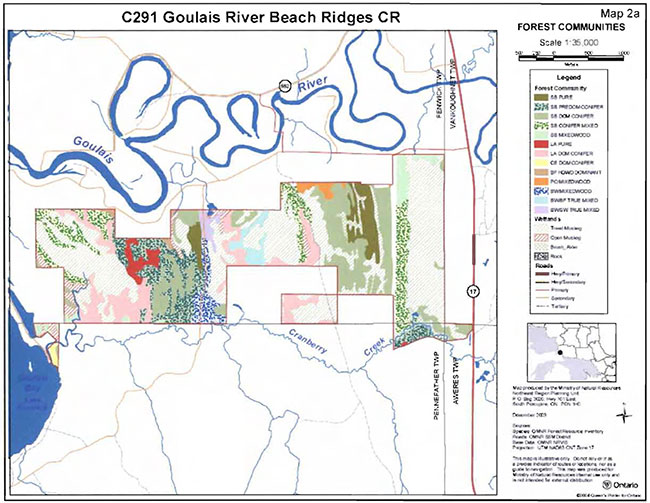
Appendix B: Supplementary photos
Photo 1: Snowshoeing during winter site visit.
(Photo by MNR; January, 2003)
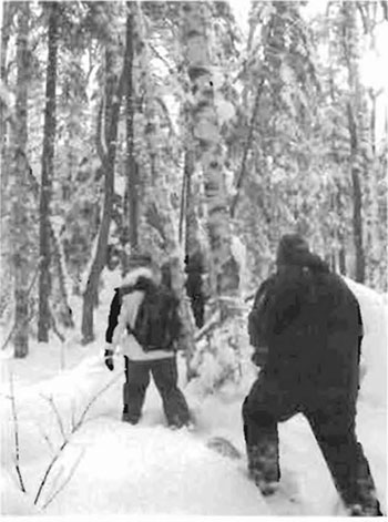
Photo 2: Open bog wetland in eastern portion of conservation reserve dominated by grasses, mosses and larch trees.
(Photo by MNR; November, 2002)
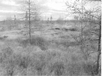
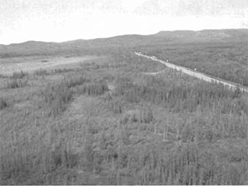
Photo 3: Aerial view looking north from southeast portion of Goulais River Beach Ridges Conservation Reserve. Highway 17 is the road shown.
(Photo by S. Walsh; September, 2003)
Appendix C: Test of Compatibility
Test of Compatibility
The Conservation Reserve policy provides broad direction with regard to the permitted uses. The policy provides only an indication of the variety of uses that will be considered acceptable in conservation reserves. Any new uses, and commercial activities associated with them, will be considered on a case by case basis, and, subject to the following test of compatibility. To ensure a standard screening process is followed, reviews of all current and new activities will be subject to the screening criteria as specified by the Environmental Assessment Act (RSO 1900, Chapter E.18).
The following outlines the two steps involved in performing a Test of Compatibility. An assessment of current activities would only follow step two, which focuses on the impacts. An assessment of any new activity would consider the impact of the activity and its conformity to the SCI/RMP.
-
Conformity to SCI/RMP: SCI describe values for which an area has been set aside and the range of appropriate uses that will be permitted in the area. SCI may also speak to the acceptability of other 'new' uses currently not occurring in the area.
The first 'test' is: "do proposed new land uses and/or commercial activities conform to the direction of the SCI/RMP for the conservation reserve? Would the new use(s) depart from the spirit of appropriate indicator land uses in the SCI/RMP?"
-
Impact Assessment: If the proposed use(s) pass test 1 it is important to determine their impact on the area before they are approved. This should include the following:
- Impact on natural heritage values: "will the new use(s) impact any natural values in the area? If so how and to what degree? Is it tolerable?"
- Impact on cultural values: "will the new use(s) impact an historical or archaeological values in the area?"
- Impact on research activities: "will the new use(s) affect research activities in the area?"
- Impact on current uses: "will the new use(s) have any negative impact on the array of current uses?"
- Impact on area administration: "will the new use(s) increase administrative costs and/or complexity?" (For example, the cost of area monitoring, security and enforcement).
- Impact on accommodating the use outside the conservation reserve: "Could the use(s) be accommodated as well or better outside the conservation reserve?"
- Impact on socio-economics of the area: "will the new use(s) affect the community(ies) surrounding the area in a positive or negative way?" (For example, will the new use make an area less remote thereby affecting a local tourism industry that is dependent on the area’s remoteness for its appeal?"
- Impact on area accessibility: "does the new use(s) give someone exclusive rights to the area or a portion of the area to the exclusion of other existing uses?"
Appendix D: Summary of permitted uses
The following Policy Report was obtained from the Crown Land Use Policy Atlas website during completion of this SCI (February 2005). Changes may have been made to this policy report since that time. For the most recent version of this policy report, please refer to the Crown Land Use Policy Atlas on the Internet at /page/crown-land-use-policy-atlas or contact your local Ministry of Natural Resources office.
Crown Land Use Atlas- Policy Report
Identification:
ID: C291
Area Name: Goulais River Beach Ridges
Area (ha): 929
Designation: Conservation Reserve - (Ontario’s Living Legacy)
District(s): Sault Ste. Marie
Description:
This area, located at the south end of the Goulais River in Site District 4E-2, is dominated by ancient beach ridges and a modem river environment of exceptional quality. The site is covered by more than a dozen vegetation communities. There are rich sedge meadows, cedar "savannah", bogs with black spruce, tamarack and moss, and "ridge-fringe" upland forests of black spruce, white birch, white pine and poplar.
Goulais River Beach Ridges was regulated as a conservation reserve on May 21, 2003.
This area is located within the Great Lakes Heritage Coast Signature Site, one of 9 such areas featured in the Ontario’s Living Legacy Land Use Strategy (1999). Signature Sites are identified for their range of natural and recreational values and their potential to contribute to future recreation and tourism.
Land use intent:
Detailed life science inventory required for further protection of sensitive natural heritage values.
Management of this area is also governed by the general policies contained in the Land Use Strategy (1999).
Management direction:
Those uses and management activities not listed in the following table are governed by existing conservation reserve policy. Over time the management direction will be elaborated in a Statement of Conservation Interest or Resource Management Plan. Any new uses, and commercial activities associated with conservation reserves, will be considered on a case by case basis, and they must pass a test of compatibility to be acceptable. Compatibility Is normally determined through a planning process.
Commercial activities
| Activity | Permitted | Guidelines |
|---|---|---|
| Aggregate Extraction | No | |
| Bait Fishing Existing: | Yes | Existing use permitted to continue, unless there are significant demonstrated conflicts. |
| Bait Fishing New: | Maybe | New operations can be considered, subject to the "test of compatibility" |
| Commercial Fishing Existing: | Yes | Existing use permitted to continue, unless there are significant demonstrated conflicts. |
| Commercial Fishing New: | Maybe | New operations can be considered, subject to the "test of compatibility". |
| Commercial Fur Harvesting Existing: |
Yes | Existing use permitted to continue, unless there are significant demonstrated conflicts. Existing trap cabins can continue; new cabins are not permitted. |
| Commercial Fur Harvesting New: |
Maybe | New operations can be considered, subject to the "test of compatibility". |
| Commercial Hydro Development | No | |
| Commercial Timber Harvest |
No | |
| Commercial Tourism Existing: | Yes | Existing authorized facilities can continue, unless there are significant demonstrated conflicts. |
| Commercial Tourism New: | Maybe | New tourism facilities can be considered during the planning for an individual reserve. |
| Bear Hunting by Non residents (guided) Existing: | Yes | Existing authorized operations permitted to continue. |
| Bear Hunting by Non residents (guided) New: | No | New operations not permitted. |
| Outfitting Services Existing: | Yes | Existing authorized operations permitted to continue. |
| Outfitting Services New: | Maybe | New operations can be considered during the planning for an individual reserve. |
| Outpost Camps Existing: | Yes | Existing authorized facilities permitted to continue. |
| Outpost Camps New: | Maybe | New facilities can be considered during the planning for an individual reserve. |
| Resorts/lodges Existing: | Yes | Existing authorized facilities permitted to continue. |
| Resorts/lodges New: | Maybe | New facilities can be considered during the planning for an individual reserve. |
| Energy Transmission and Communications Corridors Existing: | Yes | These facilities should avoid conservation reserve lands wherever possible. |
| Energy Transmission and Communications Corridors New: | No | |
| Food Harvesting (Commercial) Existing: | Maybe | |
| Food Harvesting (Commercial) New: | Maybe | |
| Mineral Exploration and Development | No | |
| Peat Extraction | No | |
| Wild Rice Harvesting Existing: | Yes | |
| Wild Rice Harvesting New: | Maybe |
Land and resource management activities
| Activity | Permitted | Guidelines |
|---|---|---|
| Crown Land Disposition Private Use: | Maybe | Sale of lands is not permitted, except for minor dispositions in support of existing uses (e.g. reconstruction of a septic system). Renewals of existing leases and land use permits are permitted. Requests for transfer of tenure will be considered in the context of the Statement of Conservation Interest or Resource Management Plan. |
| Crown Land Disposition Commercial Use: | Maybe | New leases or land use permits permitted for approved activities. Tourism facilities can apply to upgrade tenure from LUP to lease. |
| Fire Suppression | Yes | Fire suppression policies are similar to adjacent Crown lands, unless alternative fire policies have been developed through a planning process. |
| Fish Habitat Management | Maybe | |
| Fish Stocking | Maybe | Existing authorized operations permitted to continue. New operations not permitted. |
| Inventory/Disease Supperssion | Maybe | |
| Inventory/Monitoring | Maybe | |
| Prescribed Burning | Maybe | |
| Roads (Resource Access) Existing: | Yes | Existing roads can continue to be used. Continued use will include maintenance and may include future upgrading. |
| Roads (Resource Access) New: | Maybe | New roads for resource extraction will not be permitted, with the exception of necessary access to existing forest reserves for mineral exploration and development. |
| Vegetation Management | Maybe | Conservation Reserves policy indicates that Featured Species Management and Natural Systems Management may be permitted. Vegetation management can be considered in a planning process. |
| Wildlife Population Management | Maybe |
Science, education and heritage appreciation
| Activity | Permitted | Guidelines |
|---|---|---|
| Collecting | No | |
| Historical Appreciation | Yes | |
| Nature Appreciation | Yes | |
| Photography and Painting | Yes | |
| Research | Yes | |
| Wildlife Viewing | Yes |
Recreation activities and facilities
| Activity | Permitted | Guidelines |
|---|---|---|
| All Terrain Vehicle Use On Trails: | Yes | Existing use permitted to continue where it does not adversely affect the values being protected. ATV use off trails is not permitted except for direct retrieval of game. |
| All Terrain Vehicle Use Off Trails: | No | |
| Campgrounds | Maybe | |
| Food Gathering | Yes | |
| Horseback Riding(trail) | Yes | Existing use on trails permitted. |
| Hunting | Yes | |
| Mountain Bike Use | Yes | Existing use on trails permitted. |
| Motor Boat Use Commercial: | Yes | |
| Motor Boat Use Private: | Yes | |
| Non-motorized Recreation Travel | Yes | |
| Private Recreation Camps (Hunt Camps) Existing: | Yes | |
| Private Recreation Camps (Hunt Camps) New: | No | Existing camps permitted to continue, and may be eligible for enhanced tenure, but not purchase of land. |
| Rock Climbing | Maybe | |
| Snowmobiling On Trails: | Yes | Existing use permitted to continue where it does not adversely affect the values being protected. |
| Snowmobiling Off Trails: | Maybe | Snowmobile use off trails is not permitted, except that snowmobiles may be used for direct retrieval of game. |
| Sport Fishing | Yes | |
| Trail Development Existing: | Yes | Development of trails for a variety of activities (e.g. hiking, cross-country skiing, cycling, horseback riding, snowmobiling) can be considered as part of planning for an Individual reserve. |
| Sport Fishing Trail Development New: | Maybe |
Note: The policies outlined in this table do not supersede any Aboriginal or treaty rights that may exist, or other legal obligations.
Management of this conservation reserve is carried out within the context of Conservation Reserve policy as amended by the policies for new conservation reserves outlined in the Ontario’s Living Legacy Land Use Strategy.
Source of direction:
Ontario’s Living Legacy Land Use Strategy (1999)
Conservation Reserves Policy (1997)
Appendix E: Regulation public consultation materials
Note that some information in these materials is no longer current- the documents are provided here as a matter of historical record.
September 1, 2000
To: Ontario Living Legacy Stakeholders
Dear Sir/Madam:
On July 16, 1999, the Ontario Government released the Ontario’s Living Legacy Land Use Strategy, a broad land use approach to the planning and management of much of the Crown lands in central and parts of northern Ontario. A major part of the Ontario’s Living Legacy Land Use Strategy was a government commitment to the biggest expansion of provincial parks and conservation reserves in Ontario’s history. Ontario intends to add 378 new areas to its protected areas system. Ontario’s Living Legacy is a momentous achievement that will be recognized around the world as a significant contribution to sustaining our natural environment. A copy of the Land Use Strategy is available from our office upon request.
In accordance with the recommendations in the Land Use Strategy, the Ministry of Natural Resources is now implementing the process of establishing these 378 new protected areas. The first step in this process is for the Ministry to consult on the boundaries of these areas. In November 1999, MNR held boundary consultations on 64 sites across the OLL Planning Area. Eight of these sites were within Sault Ste. Marie District. At this time, Sault Ste. Marie District has prepared 19 more sites for boundary refinement consultation. Adjacent Districts are consulting an additional two sites, which are also partially contained within Sault Ste. Marie District, on. In future years, the remaining recommended protected areas from the Land Use Strategy will be put forward for similar consultations. As stated in the Land Use Strategy, the boundary refinement process will consider local ecological information and will attempt to establish regulated boundaries along features that can be identified on the ground. The boundary refinement process may result in modest increases or decreases in the sizes of the protected areas. Any existing commitments for the areas, which were considered during the land use planning process, will be considered in defining the final boundary.
Following is a list of the 21 sites in SSM District scheduled for boundary consultation this year. These sites include both provincial parks and conservation reserves. The Land Use Strategy established the Ministry’s intent to add these Crown lands to Ontario’s protected areas system, following the extensive public consultation associated with Ontario’s Living Legacy and the Lands for Life land use planning initiatives between 1997 and 1999. The Ministry is inviting public comment on the proposed boundaries of these protected areas prior to their finalization and ultimate regulation under the Provincial Parks Act or the Public Lands Act.
- C227- Glen Crombie Conservation Reserve
- P238 - Mississagi River Provincial Park Additions
- C243- Wagong Lake Forest Conservation Reserve
- C244 - Rawhide Lake Conservation Reserve
- C246 - Echo River Hardwoods Conservation Reserve
- C247- Byrnes Lake White Birch Conservation Reserve
- P253 - Goulais River Provincial Park
- C256 - Basswood Lake Hemlock Conservation Reserve
- C258- Thessalon River Delta I Rock Lake Red Oak Conservation Reserve
- C260 - Rose Lake Dune Peatland Complex Conservation Reserve
- C262 - Stuart Lake Wetland Conservation Reserve
- P273 - Algoma Headwaters Provincial Park
- P274- Wenebegon River Provincial Park
- P277- Aubinadong- Nushatogaini Rivers Provincial Park
- P278 - Pancake Bay Provincial Park Additions
- P282- Batchawana River Provincial Park
- P285- Sandy Islands Provincial Nature Reserve
- C289 - Searchmont South Forest Conservation Reserve
- C291 - Goulais River Beach Ridges Conservation Reserve
- P292- Lake Superior Provincial Park Additions
- C307 - lle Parisienne Conservation Reserve
Your name and address have been included within a Ministry mailing list of persons potentially interested in these boundary consultations. The mailing list includes a range of individuals and groups, such as nearby landowners, resource users, persons with other rights or tenure (e.g. land use permit, Mining Act rights), municipalities, and others who may have an interest in the area. Accompanying this letter, you will find background information (factsheets, maps) for the site(s) we have determined to be of interest to you. More detailed maps and information about the proposed boundaries for all 21 sites are available from this office, or from the Blind River Area Office, 62 Queen Ave., Blind River.
In the future and subject to the intended regulation of these areas as provincial parks and conservation reserves, Ontario Parks and the Ministry of Natural Resources will undertake a management planning process to determine the long-term management of these protected areas. Depending upon the complexity of issues related to the provincial parks, management planning may take the form of a simple Interim Management Statement or a more detailed Park Management Plan. In the case of planning for conservation reserves, a simple Statement of Conservation Interest or a more detailed Resource Management Plan will result. Please let us know if you would like to be notified when planning begins.
Planning, management and permitted uses within these provincial parks and conservation reserves would be consistent with the commitments of the Ontario’s Living Legacy Land Use Strategy.
The Ministry is collecting comments and information regarding these proposed provincial park and conservation reserve boundary reviews under the authority of the Provincial Parks Act and the Public Lands Act respectively. These comments will assist the Ministry in making decisions and determining further public consultation needs. Comments and opinions will be kept on file and may be included in study documentation that is made available for public review. Under the Freedom of Information and Protection of Privacy Act (1987), personal information will remain confidential unless prior consent is obtained. However, the Ministry may use this information as public input on other resource management surveys or projects. For further information regarding this Act, please contact Paul Glassford, A/Information Management Supervisor, Ministry of Natural Resources, Sault Ste. Marie District (705-949-1231).
If you would like to discuss the proposed boundaries and the protection of these areas under the Provincial Parks Act and/or the Public Lands Act, please contact Erin Nixon, District Planner, Ministry of Natural Resources, 64 Church Street, Sault Ste. Marie, Ontario, P6A 3H3; telephone 705-949-1231 ext. 247, fax 705-949-6450, by October 6, 2000. Further information on Ontario’s Living Legacy is available in our office or by visiting the Ministry’s internet website at /ministry-natural-resources-and-forestry/.
Thank you for your interest.
Yours sincerely,
Dick Hagman
A/District Manager
Sault Ste. Marie District
DH/sw
Attachments- Provincial Park and/or Conservation Reserve Factsheet(s)
Proposed Site Boundary Map(s)
Key Map
Permitted Uses Table(s) for Provincial Parks and/or Conservation Reserves
On peut obtenir Ia version franc;aise de la presente lettre en s'adressant au bureau du MRN le plus proche, a l'adresse ou au numero de telephone ci-dessous.
Goulais River Beach Ridges Conservation Reserve (C291) Fact Sheet
September 2000
Background
On July 16, 1999, the Ontario Government released the Ontario’s Living Legacy Land Use Strategy to guide the planning and management of Crown lands in central and parts of northern Ontario. A major part of the Ontario’s Living Legacy Land Use Strategy was a government intent to establish 378 new protected areas. This commitment marks the biggest expansion of provincial parks and conservation reserves in Ontario’s history.
The proposed Goulais River Beach Ridges Conservation Reserve is part of this significant expansion of Ontario’s protected areas' system.
Size and location
The Goulais River Beach Ridges Conservation Reserve is located approximately 20 km north of Sault St. Marie. South of the Goulais River, this 1,008-ha conservation reserve is located in an area east of Lake Superior’s Goulais Bay, and west of the Trans Canada highway. It lies mainly within Fenwick Township, but also extends into Aweres and Pennefather Townships.
Area highlights
The Goulais River Beach Ridges Conservation Reserve is located within ecological site district 4E-2. This site district extends approximately 60-90 km inland from the eastern shore of Lake Superior, and is characterized by rugged topography and elevations exceeding 450 m. The topography is the result of numerous geological structures such as faults, joints, and diabase dikes that dissect the area. The bedrock uplands have a thin layer of sandy soil on slopes and thicker soils in the valleys. Exposed bedrock is common, and dates back billions of years to the Precambrian and Cambrian periods.
The Goulais River Beach Ridges Conservation Reserve protects an expansive area of ancient raised beach ridges. The site is characterized by gentle topography that alternates between upland ridges and low-lying wetland areas. This is part of an outwash valley plain that was created over the centuries by the flow of the Goulais River. Soils here are typically sandy and silty on the ridges, and organic in the intervening depressions. A rich diversity of vegetation communities occur within this ridge and swale environment, including rich sedge meadows, cedar "savannah" swamps, bogs with black spruce, tamarack and moss, and "ridge-fringe" upland forests of black spruce, white birch, white pine and poplar.
The site is surrounded by patent land. It is traversed by two roadways, a powerline transmission corridor, and a network of snowmobile trails. It is recognized as providing excellent moose habitat. A diversity of bird species, ranging from waterfowl to forest songbirds, inhabit the area.
Land use intent
Conservation reserves are areas of Crown land set aside by regulation under the Public Lands Act. Conservation reserves complement provincial parks in protecting representative natural areas and special landscapes. Most recreational (e.g. hiking, skiing, tourism related uses, nature appreciation) and non-industrial (e.g. fur harvesting, commercial fishing and bait harvesting) activities that have traditionally been enjoyed in the area will continue, provided that these uses do not impact on the natural features needing protection. Hunting and fishing are also permitted within all new conservation reserves recommended through Ontario’s Living Legacy.
Commercial timber harvesting, mining, aggregate extraction and commercial hydroelectric development are prohibited in conservation reserves. Careful mineral exploration may occur in specific new conservation reserves proposed through Ontario’s Living Legacy, in areas that have provincially significant mineral potential. If a portion of a new conservation reserve is to be developed for a mine, it would be removed from the reserve, and appropriate replacement lands would be placed in regulation. Please refer to Table 4 from the Land Use Strategy for a detailed summary of permitted uses in conservation reserves.
Next steps
The Land Use Strategy established the Ministry’s intent to add these Crown lands to Ontario’s protected areas system, following the extensive public consultation associated with the Ontario’s Living Legacy and Lands for Life land use planning initiatives between 1997 and 1999. Prior to the finalization of the boundary of this conservation reserve proposed for regulation under the Public Lands Act, the Ministry is inviting public comment on the proposed boundary from all potentially affected stakeholders and First Nations from September 1 to September 30, 2000.
In the interim, the area has been withdrawn and protected from resource extraction activities such as timber harvesting, hydroelectric development, aggregate extraction and new mineral exploration.
In the future and subject to the intended regulation of the area as a conservation reserve, the Ministry of Natural Resources will prepare a long term management plan for this area. Depending upon the complexity of issues within this conservation reserve, management planning may take the form of a simple Statement of Conservation Interest or a more detailed Resource Management Plan. Please let us know if you would like to be notified when planning begins.
Planning, management and the uses permitted within this conservation reserve will be consistent with the commitments of the Ontario’s Living Legacy Land Use Strategy.
For more information
For further information on the proposed Goulais River Beach Ridges Conservation Reserve, please contact Erin Nixon, District Planner, Ministry of Natural Resources, Sault Ste. Marie District ( 705-949-1231 ext. 247). You may also visit the Ministry’s internet website at www.mnr.gov.on.ca/MNR/oll/ (link no longer active) for information about Ontario’s Living Legacy.
64 Church Street
Sault Ste. Marie, ON P6A 3H3
Telephone: 705-949-1231 ext. 210
Facsimilie: 705-949-6450
E-mail: serge.tenaglia@mnr.gov.on.ca
November 24, 2003
To: Ontario’s Living Legacy Stakeholders
Re: Invitation to Review Draft Statements of Conservation Interest and Update on Ontario’s Living Legacy Protected Areas in Sault Ste. Marie District
Sault Ste. Marie District has been working for the past four years on establishing and planning for a number of new protected areas within the district, as a result of the Lands for Life and Ontario’s Living Legacy programs. I am pleased to report that as of June 2003, 36 of the 38 new protected areas are now protected from industrial uses such as commercial forestry, hydroelectric development, mining, and aggregate and peat extraction. This includes 22 conservation reserves and 14 of 16 provincial park or park additions. See the attached table and map for the names, locations and status of all new protected areas within the district. Detailed maps showing the final regulated boundaries for the district’s 38 new protected areas can be viewed at either the Sault Ste. Marie District or Blind River Area offices (addresses below).
Once a protected area is regulated, a planning process is undertaken to produce a site specific management plan. Management plans usually include a description of the natural and cultural features within the protected area, as well as provide details regarding the range of permitted and non-permitted activities. Ontario Parks is responsible for developing a management plan for each new provincial park and park addition. Sault Ste. Marie District however retains responsibility for managing all conservation reserves within the district. Management plans for conservation reserves typically are in the form of a Statement of Conservation Interest (SCI), but may be elevated to a more detailed Resource Management Plan (RMP) if complex issues arise, or there is widespread public interest in a site. As of June 2003, 9 of 22 conservation reserves in the district have approved SCIs. This year, work is progressing on 7 additional SCIs. From December 1-15, 2003, you are invited to review and comment on draft versions of the SCI documents for any/all of the following conservation reserves:
- C245 Jollineau Conservation Reserve
- C246 Echo River Hardwoods Conservation Reserve
- C247 Byrnes Lake White Birch Conservation Reserve
- C256 Basswood Lake Hemlock Conservation Reserve
- C257 Basswood Lake Conservation Reserve
- C263 Garden River Forest Conservation Reserve
- C266 Galbraith Peatlands Conservation Reserve
Copies of the draft SCI documents are available for review at either the Sault Ste. Marie District or Blind River Area offices. If you require additional information or would like to comment on the draft management plans for these conservation reserves, please contact either Sheila Walsh, OLL Planner, Sault Ste. Marie District office or Joey Young, OLL Intern, Blind River Area office (contact information listed below). Comments will be accepted until December 15, 2003.
The Ministry of Natural Resources is collecting comments and information regarding these draft Statements of Conservation Interest under the authority of the Environmental Assessment Act to assist in making decisions and determining future public consultation needs. These comments will assist the Ministry in making decision and determining further public consultation needs. Comments and opinions will be kept on file and may be included in study documentation that is made available for public review.
Under the Freedom of Information and Protection of Privacy Act (1987) personal information will remain confidential unless prior consent is obtained. However, this information may be used by the Ministry of Natural Resources to seek public input on other resource management surveys and projects. For further information on this Act, please contact Mr. Tom Mispei Beyer at 705-949-1231 ext.288.
Thank you for your interest in protected areas planning and management in Sault Ste. Marie District.
Yours truly,
Serge Tenaglia R.P.F.
District Manager
Sault Ste. Marie District
ST/sw
Attach. Map of Sault Ste. Marie District Ontario’s Living Legacy Sites
Status of Ontario’s Living Legacy Protected Areas in Sault Ste. Marie District
Sheila Walsh
Sault Ste. Marie District Office
64 Church St.
Sault Ste. Marie, ON P6A 3H3
Telephone: 705-949-1231 ext. 218
Facsimllie: 705-949-6450
Email: sheila.walsh@mnr.gov.on.ca
Joey Young
Blind River Area Office
62 Queen Avenue
Blind River, ON P0R 1B0
Telephone: 705-356-2234 ext. 218
Facsimilie: 705-356-7441
Email: joey.young@mnr.gov.on.ca
Appendix F: Amendments to the SCI
1Ecological site districts are areas characterized by physiographic similarities, and by the successional trends exhibited by the predominant vegetation types on those physiographic features (Hills 1959). See Section 5.0 for more details.
2Stocking is defined as a qualitative measure of the density of tree cover in a forest stand. Stocking represents the density of forest stems based on average age, height, and the working group (the dominant tree species) in a forest stand (OMNR 2001a).