Grassy River Halliday Lake Forests and Lowlands Conservation Reserve Management Statement
This document provides policy direction for the protection, development and management of the Grassy River Halliday Lake Forests and Lowlands Conservation Reserve and its resources.
Statement of Conservation Interest
Version 1.0
December 2004
Approval statement
I am pleased to approve this Statement of Conservation Interest for the Grassy River Halliday Lake Conservation Reserve.
The management direction for this conservation reserve is in the form of a Statement of Conservation Interest. The Statement of Conservation Interest defines the area that is being planned, the purpose for which the conservation reserve has been proposed, and it outlines the Ministry of Natural Resources' intent for the protected area. This Statement of Conservation Interest will provide guidance for the management of the conservation reserve and the basis for the ongoing monitoring of activities.
Direction for establishing, planning and managing conservation reserves is defined under the Public Lands Act and current policy. "Ontario’s network of natural areas has been established to protect and conserve areas representative of the diversity and the natural regions of the province, including species, habitats, features and ecological systems which comprise that natural diversity" (OMNR 1997). Detailed direction and defined management will be incorporated into this Statement of Conservation Interest as well as public and aboriginal consultation.
The direction herein is consistent with the Ministry of Natural Resources' Ontario’s Living Legacy Land Use Strategy (OMNR 1999). Decisions made at this time further clarify the permitted uses within the Grassy River Halliday Lake Conservation Reserve.
The Grassy River Halliday Lake Conservation Reserve will be managed under the jurisdiction of the Timmins District Ministry of Natural Resources under the supervision of the Mattagami and Nighthawk Area Supervisors as designated by the District Manager.
Written and Submitted by:
Megan Kilgour
Recommended for approval by:
Grant Ritchie
Timmins District Manager
Approved by:
Rob Galloway
Northeast Regional Director
1.0 Introduction
In 1999, Ontario’s Living Legacy Land Use Strategy identified 378 natural areas that contribute to the representation of the spectrum of the province’s ecosystems and natural features, including both biological and geological features, while minimizing impacts on other land uses. Protecting areas, species, habitats, special features and ecological systems is essential to the sustainable management of natural resources in the Province of Ontario. By ensuring representative sites are retained in their natural state, these areas can continue to contribute to Ontario’s natural environment for present and future generations (OMNR 1997).
Conservation reserves have been established to preserve sensitive areas requiring protection from incompatible uses to ensure their values will endure over time. This designation permits many traditional land uses to continue while excluding activities such as commercial timber harvest, mining, and hydroelectric development that negatively impact the conservation reserve.
The 2,292 hectare Grassy River Halliday Lake Forests and Lowlands Conservation Reserve is located just east of Mattagami First Nation in Hutt, Sothman and Halliday Townships that are in the Territorial District of Sudbury and the Administrative District of Timmins. This site falls within the historical Grassy River Waterway Area of Natural and Scientific Interest (OMNR 2004). This site together with the Mond Lake Lowlands and Ferris Lake Uplands protect unique features that are only represented in these sites within the region (OMNR 1999). The features represented in the site include white birch, cedar, and black spruce on weakly broken aeolian sands and balsam fir and red maple on lacustrine clay. Other important ecological features such as mixed forests, coniferous stands, wetlands and shoreline fen are present. The site contains two dune complexes. One large, transverse (ie. formed perpendicular to wind direction) is found along the site’s southern boundary and the other is located within the western portion of the site (OMNR, 1999).
An approved Statement of Conservation Interest (SCI), an Enhanced Statement of Conservation Interest (Enhanced SCI), or a Resource Management Plan (RMP) will guide the management and administration of each conservation reserve. This SCI will provide the management direction for the Grassy River Halliday Lake Forests and Lowlands Conservation Reserve.
2.0 Goals and objectives
2.1 Goal
This Statement of Conservation Interest will be used to identify needs and guide key management activities towards protecting site-specific values and the overall ecological integrity of the Grassy River Halliday Lake Forest and Lowlands Conservation Reserve. The management direction will protect the site’s natural heritage values and demonstrate its compatibility within the larger sustainable landscape. This direction will comply with the land use intent as stated by the Ontario’s Living Legacy Land Use Strategy (OMNR 1997; OMNR 1999).
2.2 Objectives
2.2.1 Short term objectives
The short-term objectives of this SCI are:
- To define the purpose of Grassy River Halliday Lake Forest and Lowlands Conservation Reserve
- To define the management intent for Grassy River Halliday Lake Forest and Lowlands Conservation Reserve
- To create public awareness of the values within Grassy River Halliday Lake Forest and Lowlands Conservation Reserve and promote responsible stewardship of the protected area and surrounding lands
This will be accomplished by:
- Identifying the state of the resource with respect to the protection of natural heritage values and current land use activities occurring within the Grassy River Halliday Lake Forest and Lowlands Conservation Reserve
- Determining land-use compatibilities, thus creating the best management strategy to protect the integrity of identified values
2.2.2 Long term objectives
The Statement of Conservation Interest (SCI) will determine the long-term management goals of the conservation reserve by identifying tourism and recreational use opportunities, research needs, client services and marketing strategies. By comparing scientific values found within Grassy River Halliday Lake Forest and Lowlands Conservation Reserve to provincial benchmarks, representative targets (e.g. future forest conditions) can be determined for this site. Further monitoring or research needed to identify and to maintain the integrity of these characteristics can then be established.
The SCI will also provide direction to evaluate proposed new uses or economic ventures. To accomplish this, the Test of Compatibility shall be undertaken to determine the impact of the suggested use(s), either positive or negative, on the protected values and administrative needs of the conservation reserve (Policy PL 3.03.05 OMNR 1997). The Test of Compatibility will provide rationale for decision-making within the conservation reserve, further clarifying permitted uses within the Grassy River Halliday Lake Forest and Lowlands Conservation Reserve.
3.0 Management planning
3.1 Planning context
3.1.1 Planning area
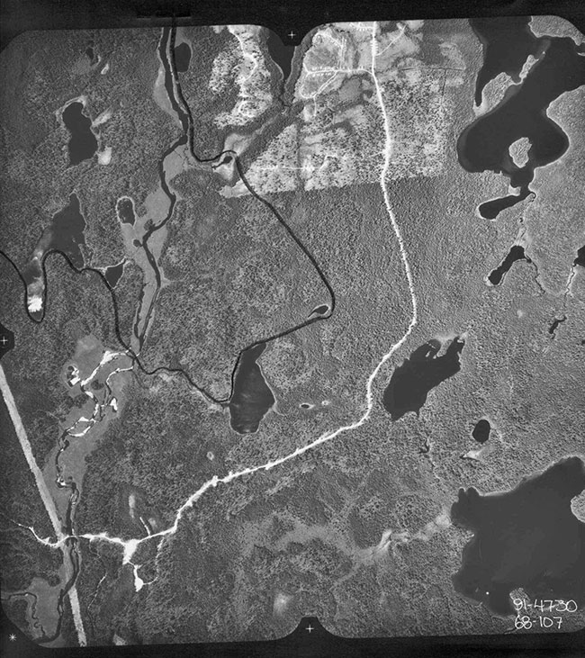
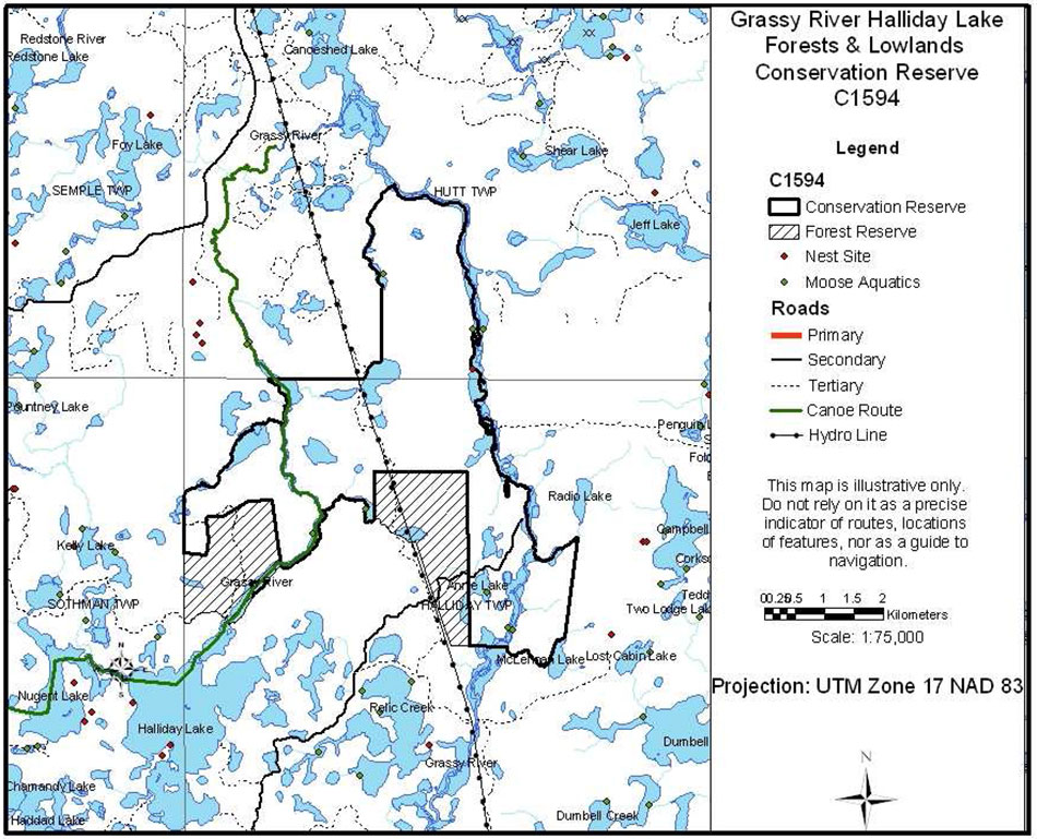
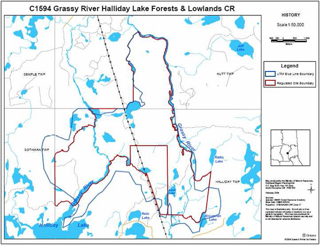
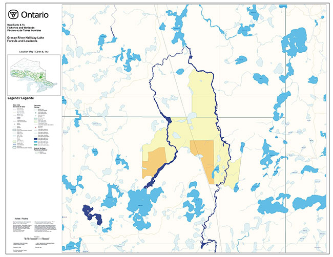
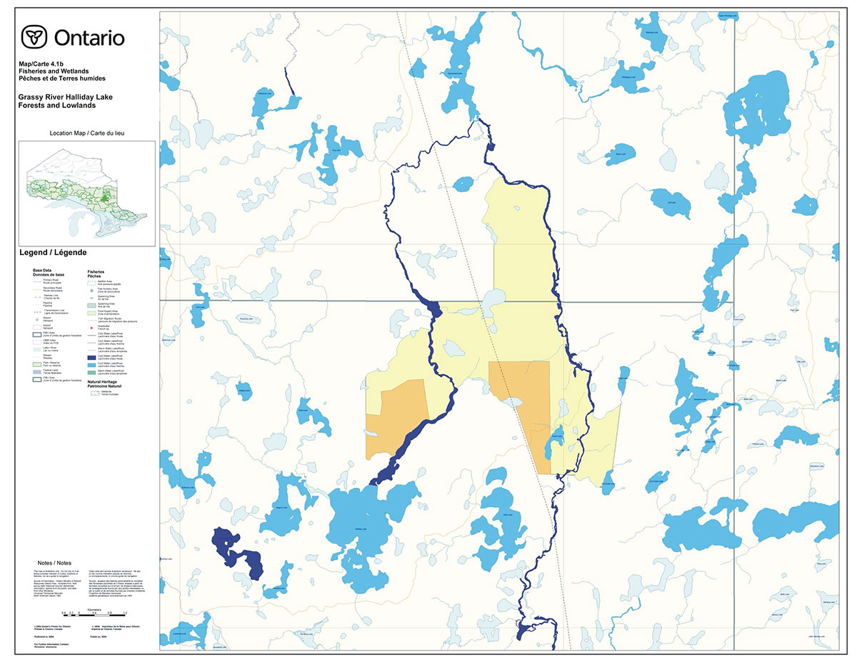
The planning area is the regulated boundary of Grassy River Halliday Lake Forests and Lowlands Conservation Reserve (Map 8.1).
The planning area will form the area directly influenced by this Statement of Conservation Interest. The plan will recognize the protection of values within the planning area, however, to fully protect values within the conservation reserve additional consideration within larger land use or resource management plans may be required. Any strategies noted within this plan related to the site’s boundary or beyond will need to be presented for consideration within a larger planning context.
3.1.2 Management planning context
The need to complete the Parks and Protected Areas system has long been recognized as an important component of ecological sustainability (OMNR 2000). This was reaffirmed in 1997 when the Lands for Life planning process was announced. Previous gap analysis studies were used to propose where candidate areas would protect additional representative life and earth science features. The Grassy River Halliday Lake Forests and Lowlands Conservation Reserve was identified as a life science site (GAP 3e5_Halliday) and was subsequently identified in Ontario’s Living Legacy Land Use Strategy as C1594 (OMNR 1999).
Conservation reserves are governed under Section 4 of the Public Lands Act and their lands and waters, as described in the Schedules, shall not be used for mining, commercial forest harvest, personal fuel wood harvesting, hydro-electric power development, the extraction of aggregates or peat or other industrial purposes (OMNR 1997).
Permitted uses in conservation reserves follow the direction expressed in the Crown Land Use Policy Atlas while ensuring prior commitments made by Timmins District, Ministry of Natural Resources are met (OMNR 1999). The Permitted Uses Table (Appendix A) illustrates the variety of uses that could potentially occur in a conservation reserve. In cases where a use already occurs, it will be permitted to continue as per the Crown Land Use Policy Atlas (OMNR 1997). Where a permitted use does not already exist in a specific conservation reserve, the permitted use would be considered a new use and subjected to the Test of Compatibility. Most recreational (e.g. hiking, boating, bird watching, hunting, fishing) and non-industrial resource uses (e.g. fur harvesting and bait harvesting) traditionally enjoyed in the area are permitted to continue.
Reflective of the management intent for Grassy River Halliday Lake and Forests and Lowlands Conservation Reserve, future uses or developments proposed for this conservation reserve will be reviewed using the Procedural Guideline B - Land Uses - Test of Compatibility found in Policy PL3.03.05 (OMNR 1997). The Test of Compatibility is conducted to weigh the future use against the potential impacts to site values. Proposed uses and/or developments may also be screened using A Reference Manual for MNR Class Environmental Assessments: Resource Stewardship and Facility Development Projects.
Consideration for proposals pertaining to the development/ use of cultural resources may be screened through Conserving a Future for Our Past: Archaeology, Land Use Planning & Development in Ontario, Section 3 (Ministry of Citizenship, Culture and Recreation 1997). Where necessary, the Ministry of Natural Resources will establish Area of Concern (AOC) descriptions and prescriptions for cultural heritage resources within forest management plans (FMPs).
These planning tools will help refine the review process once the proposal satisfies the direction and intent of the Public Lands Act, associated policies and this planning document.
3.2 Planning process
Following the completion of the land use regulation process, a planning exercise has occurred to determine the management direction for Grassy River Halliday Lake and Forests and Lowlands Conservation Reserve. Management of the conservation reserve includes, as a minimum, regulation, provision of public information, stewardship, and security. It also includes authorization and setting conditions on permitted uses and ongoing monitoring and compliance. Management of conservation reserves is the responsibility of the Ministry of Natural Resources at the District level, and will be done in accordance with Policy PL 3.03.05 (OMNR 1997) and an approved management document.
A Statement of Conservation Interest (SCI) is the minimum level of management direction established for any conservation reserve. If during the planning process major issues arise and/or it is recognized that decisions will need to be made beyond what is directed in the Crown Land Use Policy Atlas, a Statement of Conservation Interest increases to an Enhanced Statement of Conservation Interest or a Resource Management Plan. In either elevated management direction, specific permitted uses will be passed through the Test of Compatibility and decisions on future uses may be made beyond what is directed in the Crown Land Use Policy Atlas. To date, no issues have been identified in the Grassy River Halliday Lake Forests and Lowlands Conservation Reserve that would require decisions to be made beyond what was previously determined in the Crown Land Use Policy Atlas.
This SCI will govern the lands and waters within the regulated boundary of the conservation reserve. To ensure Ministry of Natural Resources protection objectives are being fully met within the conservation reserve, the surrounding landscape and related activities must be carried out in consideration of the site’s objectives and heritage values.
4.0 Background information
4.1 Location and site description
4.1.1 Location and access
The Grassy River Halliday Lake Forests and Lowlands Conservation Reserve is located 85 km south of Timmins in Hutt and Halliday Townships. It is within the Ontario Ministry of Natural Resources Administrative district of Timmins (Nighthawk and Mattagami Areas). The conservation reserve is almost entirely in Halliday Township, with the northern tip extending into Hutt Township.
The conservation reserve is found within both the Canoeshed Crothers Complex (OMNR 1984a), managed primarily for resource extraction and Crown land recreation along shorelines, and the Grassy (OMNR, 1984b), managed largely for Crown land recreation.
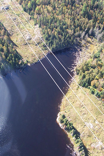
The Grassy River Halliday Lake Forests and Lowlands Conservation Reserve can be accessed by road, as there are several tertiary roads around the site (Map 8.1). It can also be accessed by canoe route. The hydro line with the underlying road divides the conservation reserve in half, running though the reserve from northwest to southeast (OMNR 1999).
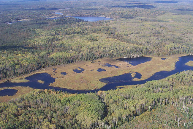
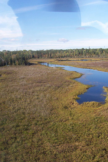
The conservation area is noteworthy for the extensive wetlands along the Grassy River and the diversity of landforms present. These include forested dunes, kettle lakes and bogs, rock outcrops and cliffs.
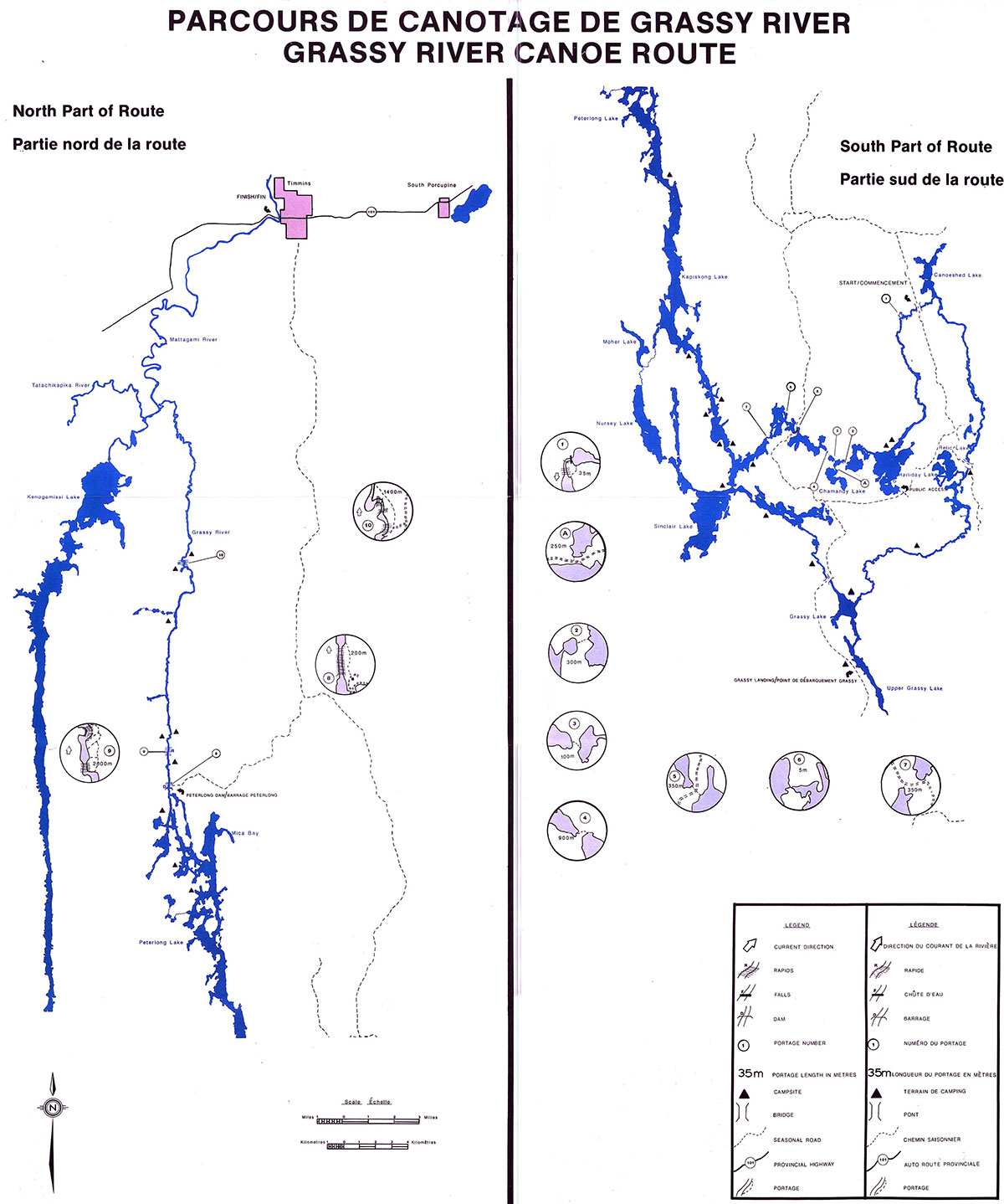
Traditionally the Grassy River’s western (Figure 3) and eastern (Figure 4) branches have formed an important waterway route. Between 1910 and 1930 rumors of gold increased activity along the waterway route from Matachewan to the Porcupine camp (OMNR 1984a). The construction of many roads in the area diminished the use of the Grassy River waterway route. More recently these same branches of the river form part of Grassy Canoe Route 4 (Map 8.2). The Grassy River Lake Forests and Lowlands Conservation Reserve is found within the regionally significant candidate Area of Natural and Scientific Interest (ANSI) Grassy Waterway Life Science Site (Geomatics International 1994).
Figure 3: Grassy River western branch
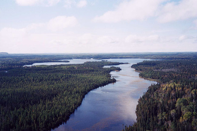
Figure 4: Grassy River eastern branch and eastern portion of site
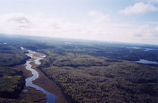
Table 1: Location and Administrative Details Grassy River Halliday Lake Forests and Lowlands Conservation Reserve
| MNR Administrative Region/District/Area | Northeast/ Timmins/ Mattagami and Nighthawk |
|---|---|
| Total Area | 2292 hectares |
| Regulation Date | |
| First Nations Interests | Mattagami First Nation, Matachewan First Nation |
| OBM Map Sheets | 2017480053000/ 2017490053000/ 2017480053100 |
| Canada Map Series | Mattagami Lake 41P/14 |
| UTM Coordinates Centroid | 17 488083 5307280 |
| Territorial District | Sudbury |
| Municipality | Unorganized |
| Township | Halliday, Hutt and Sothman |
| Status | 100% Crown Lands |
| Forest | Romeo Malette Forest and Nighthawk Forest |
4.1.2 Physical site description
Grassy River Halliday Lake Forests and Lowlands Conservation Reserve is 2, 292 hectares. The conservation reserve is located within Foleyet Ecodistrict 3E-5 within Lake Abitibi Ecoregion 3E (Crins and Uhlig 2000) and in tertiary watershed 4LA of the Moose River Basin (OMNR 2002).
Key values are those that make this site unique and have led to its designation as a conservation reserve. The key values within the Grassy River Halliday Lake Forests and Lowlands Conservation Reserve are the:
- balsam fir and red maple on lacustrine clay
- white birch, cedar, black spruce and white spruce on moderately broken end moraine
- White birch and cedar on weakly broken outwash plain
- White birch, cedar, jack pine, poplar, black spruce and white spruce on weakly broken eolian sands
- Mixed forests, coniferous stands, wetlands, excellent shoreline fen areas and waterbodies are present
- A large transverse dune complex has been identified along the site’s southern boundary with other dunes located within the western portion of the site.
- The land form vegetation combination of recent cuts on bedrock is considered significant by Ontario Parks (2003)
- This site falls within the historical Grassy River Waterway Area of Natural and Scientific Interest (ANSI)
These values were not found in any other candidate site.
4.1.3 Administrative description
The legal description of the Grassy River Halliday Lake Forests and Lowlands Conservation Reserve has been regulated as Schedule (fill in) in Ontario Regulation (fill in) under the Public Lands Act on (fill in date) and amended in Ontario Regulation (fill in).
4.2 Site history
In 1941, the Grassy became known as the Grassy Wilderness Area for district planning purposes. At this time the area was allotted for resource extraction purposes (OMNR 1984a). This was and still is used extensively by First Nations trappers. During the 50s and 60s, the Department of Indian Affairs purchased the rights to fourteen areas in the Grassy. The area has also been used for recreational camping on the Upper Grassy Lake and Halliday Lake (OMNR 1984a). The Grassy was used for log driving, from northern operations to mills in Timmins up until 1971 (OMNR 1984a).
The Grassy River Halliday Lake Forests and Lowlands Conservation Reserve contains part of a historically important waterway route. Between 1910 and 1930 the route was essential for transporting people and resources from Matachewan to the Porcupine camp (OMNR 1984a).
This route was essential for transporting people and resources between these northern communities. The construction of many roads in the area diminished the use of the Grassy River waterway route.
Forest harvesting took place outside of the conservation reserve on the east side of the Grassy River in 1989. This cut extends into the conservation reserve near the most eastern tip in Halliday Township (Appendix: B). The fire history of the area is not documented, although Forest Resource Inventory maps show that fire has been absent from the conservation reserve area for the past 80-120 years.
4.3 Inventories
Three inventories have been completed for the Grassy River Halliday Lake Forest and Lowlands Conservation Reserve:
- Earth science check sheet (Kristjansson 2004)
- Recreation inventory checklist by Timmins District MNR (Irving 2003)
- Life science check sheet by Geoscience (Cudmore et al. 2004)
5.0 State of the resource
The natural heritage of Ontario contributes to the economic, social and environmental well-being and health of the province and its people. Protecting areas of natural heritage is therefore important for many reasons, such as maintaining ecosystem health and providing habitat in order to maintain species diversity and genetic variability. Protected areas also provide scientific and educational benefits. They generate tourism, thereby bolstering local and regional economies, and provide places where people can enjoy and appreciate Ontario’s natural diversity (OMNR 1997).
5.1 Representation
The Grassy River Halliday Lake Forests & Lowlands Conservation Reserve falls within the historical Grassy River Waterway Area of Natural and Scientific Interest (ANSI). This site together with the Mond Lake Lowlands and Ferris Lake Uplands contain features unrepresented in other sites identified in the region. Representation features include: some balsam fir and red maple on lacustrine clay, white birch, cedar, black spruce and white spruce on weakly broken aeolian sands. Mixed forests, coniferous stands, wetlands and excellent shoreline fen areas are present. A large, traverse (ie. formed perpendicular to wind direction) dune complex has been identified along the site’s southern boundary with other dunes located within the western portion of the site. White pine are scattered throughout the site (OMNR 1999).
5.1.1 Life science
The Grassy River Halliday Lake Forests and Lowlands Conservation Reserve is found within the Foleyet ecodistrict 3E-5 of the Lake Abitibi ecoregion 3E (Hills 1959). The ecoregion is distinguished by gently rolling plains of thinly covered rock knobs, sandy outwash and silty depressions. The ecoregion climate is moderate micro thermal, moist, humid southern boreal (OMNR 2001). The forest of this ecoregion is typical of the boreal forest.
The Grassy River Halliday Lake Forests and Lowlands Conservation Reserve is located in the tertiary watershed 4LA of the Moose River Basin (OMNR 2002). The Halliday Lake system south of the conservation reserve forms the headwaters of the Grassy River. From here the river flows north into Canoeshed Lake, then flows south (to the east side of the reserve), around to the west of the Halliday Lake area into the Kapiskong/Peterlong Lakes system. The outflow is in the Mattagaimi River. The river is at the north end of the tertiary watershed.
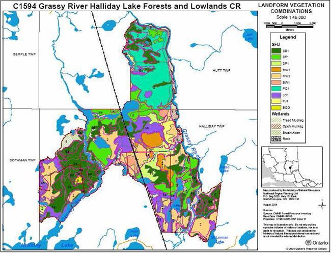
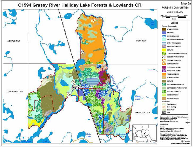
The northern section of the conservation reserve is predominantly poplar hardwood mixed forest with some black spruce predominant coniferous forest. The western arm is dominated by pure black spruce stands. The eastern arm has a variety of communities, with mixed black spruce conifer and black spruce mixedwood dominating the site. The pattern of the forest communities closely matches the geological boundaries (Map 8.3).
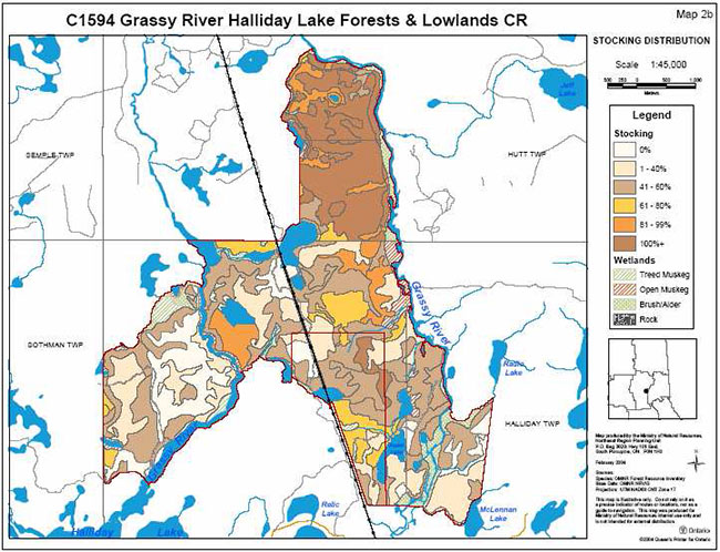
The conservation reserve does not have a dominant forest community, as they are relatively evenly represented. The three leading communities include poplar hardwood mixed (12.8% of the total area), pure black spruce stands (12.5% of total area) and mixedwood black spruce stands (9.7% of the total area) (Cudmore et al. 2004) (Map 8.4).
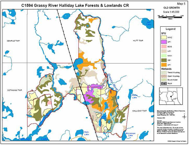
Within the conservation reserve there is a wide range in the ages of the stands, from 20 to 166 years. The northern section contains some older stands (90-149) but is dominated by mature stands (60-89). The western arm contains a central area of younger stands surrounded by older trees. The eastern arm is dominated by two older age groups of trees (90-119 and 120-149) (Cudmore et al. 2004). The site contains many different candidate old growth areas according to FRI data based on Bridge et al. (2000) definitions (see Map 8.5).
Photo 1: Western arm black spruce stand (Irving 2003).
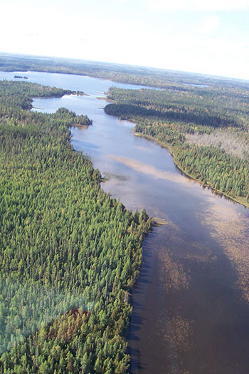
Photo 2: Northern section poplar hardwood mixed forest (Irving 2003).
The majority of the conservation reserve is stocked at greater than 60% (Map 8.5) and is aged between 60 and 119 years. Areas with forest stands older than 120 years occur in three locations throughout the site and include white birch, jack pine and black spruce (Bridge et al. 2000; King et al. 2003; Map 8.4).
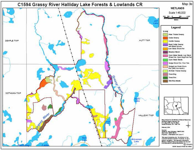
Wetlands within the conservation reserve are more abundant in the south due to lower elevations than the north. Wetland areas include a mixture of shore fens, poor fens, meadow marshes, conifer swamps, thicket swamps and a semi-treed bog (King et al. 2003; Map 8.2.4).
5.1.2 Earth science
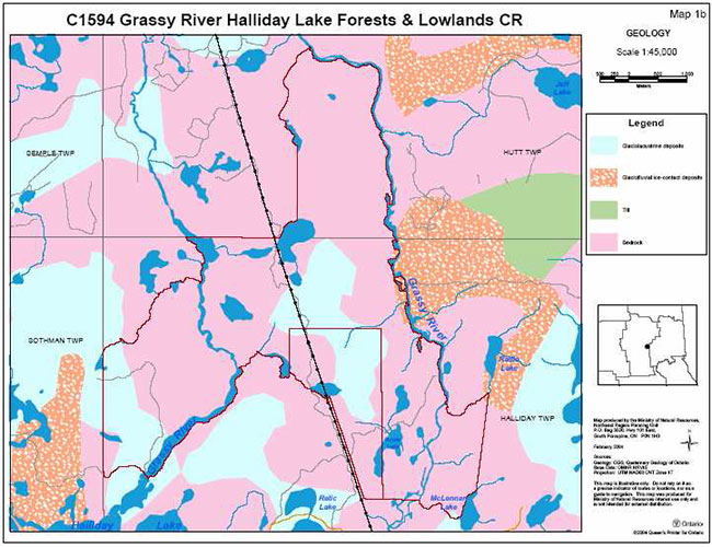
There are three dominant landforms in the conservation reserve according to the quaternary geology of Ontario coverage in the Grassy River Halliday Lake Forests and Lowlands Conservation Reserve (Map 8.7). Bedrock dominates the whole site. Glaciolacustrine deposits are found in two sections, along the west arm in the southwestern section and centrally; glaciofluvial ice-contact deposits are located along the Grassy River shoreline on the central eastern boundary and at the northeastern tip of the eastern arm.
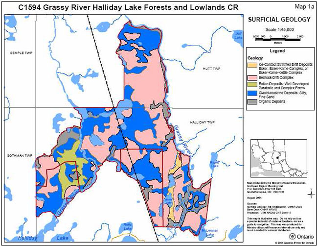
The underlying bedrock composition is undifferentiated metavolcanic rock of Abitibi subprovince, superior province and precambrian shield (Ontario Geological Survey 1991, Map 8.7). The surficial geology in this site includes organic deposits, aeolian deposits that are well developed parabolic and complex forms, glaciolacustrine deposits of silty fine sand, ice-contact stratified drift deposits with an esker-kame complex and bedrock-drift complex and the drift cover is predominantly till (Kristjansson, 1994). Refer to the surficial geological map (Map 8.8) for the occurrence and distribution of these surficial geological units in the conservation reserve.
A number of small to fairly extensive areas of bedrock-drift complex occur throughout the conservation reserve. The morphology of the bedrock surface ranges from mostly flat, somewhat uneven areas with low relief to bedrock knoll areas with moderate local relief. In some places there is only minor bedrock exposure, while in others it is exposed in moderate amounts. The drift cover ranges from thin but continuous to thin and discontinuous and is composed principally of till deposits, with small amounts of glaciolacustrine sand deposits (Kristjansson 2004).
There are two areas of esker-kame-kettle complex in the southeast part of the conservation reserve. Small to medium sized areas immediately underlain by glaciolacustrine deposits are scattered throughout the conservation reserve. The glaciolacustrine deposits are made of silty, fine sand.
In the southwest part of the conservation reserve there is a large area immediately underlain by eolian deposits. Various well developed sand dunes are present within this part of the conservation reserve (Geomatics International 1994). In this area there is also a large area of organic deposits along the tributary of the Grassy River. A similar area of organic deposits is located in the southeast part of the conservation reserve and is related to the course of the Grassy River. Other smaller areas of organic deposits are scattered throughout the conservation reserve.
The geological features found in the conservation reserve are common to the region and are considered to be of local significance (Kristjansson 2003). Generally, the earth science features in the reserve are considered to have low sensitivity. The sand dunes are the most sensitive feature. Depending on the vegetative cover they can be sensitive to even passive activities such as hiking. The larger organic deposits in the southwestern and southeastern parts of the conservation reserve may be sensitive to all terrain vehicle traffic (Kristjansson 2004).
5.1.3 Quality of present representation
The quality of the representation or the current characteristics of the natural features found within the conservation reserve are as important as the overall representative features that are being protected. A number of criteria are considered in evaluating a site including: diversity, ecological factors, condition, special features and current land use activities.
a) Diversity
Diversity is a measure of the site’s life and earth science heterogeneity. It is based on the number and range of the natural landscape features and landforms of earth science values and the richness and evenness of the life science components (Hills 1959). It has been suggested that the best way to represent all ecosystems is to maintain the full array of physical habitats and environmental gradients in reserves (Noss 1993). Representative vegetation types can be protected by protecting the range of conditions which produce the various microhabitats throughout an area.
A total of 11 major landform types have been identified within the Grassy River Halliday Lake Forests and Lowlands Conservation Reserve (Geomatics International 1994). These include ground moraine, outwash and lacustrine deposits, eskers, dunes, till, kames, kettles, rock knobs, cliffs and valley trains.
The diversity rating for conservation reserves is based on the number of landform: vegetation combinations. A recent OMNR analyses of the landform: vegetation combinations identified 21 different combinations, giving the Grassy River Halliday Lake Forests and Lowlands Conservation Reserve a diversity rating of medium (2004).
The Life Science Check sheet for the CR (Cudmore et al. 2004) lists the dominant landform: vegetation combinations as:
- glaciolacustrine deposits – silty fine sand with black spruce dominant conifer stands bedrock-drift complex- drift cover is predominantly till with mixwood forest including black spruce, balsam, fir and poplar bedrock-drift complex- drift cover is predominantly till with poplar dominant
- intolerant hardwood forest
The forest resource inventory data for the conservation reserve counts ten different forest units. There are not many zonal communities in the site as they are all over 10 ha in size, which increases the diversity of the site. The azonal communities in the site include the Grassy River, wetlands and the sand dunes (Cudmore et al 2004).
The wide variety wetlands found in the conservation reserve are wetter than normal communities and add to the reserve’s diversity. In contrast the dunes on the southern boundary are dryer than normal communities. The many lakes in the eastern arm of the conservation reserve contribute to the diversity of the site. Finally, the wild rice bed is unique to the region and has great potential as duck breeding grounds (OMNR 1972).
Photo 3: Wild rice beds (Irving 2003).
Based on the size of the site, the number of forest communities, developmental stage and earth science features, the diversity rating of the conservation reserve is considered to be medium. In 1994 an evaluation of feature representation in the Grassy River area, Geomatics International found that there are 29 different site types, 184 vascular and 131 nonvascular plant species, and 76 species of animals within the study area.
b) Ecological factors
Ecological factors refer to current design of the conservation reserve including its size, shape and the ability of the site to maintain itself over time (Thompson 1999). A site’s boundaries should be created to include the greatest diversity of life and earth science features to provide the maximum ecological integrity possible. It should be ecologically self-contained, bounded by natural features and include adequate area to buffer the core ecosystems from adjacent land use activities (OMNR 1992).
While some of the conservation reserve’s boundaries are biological, others are cultural and a few are vectored. The biological boundaries follow natural water bodies. There are three cultural boundaries: the western side of the western arm which follows the Sothman and Halliday township line and its northern part that follows the Hutt and Halliday township line. The third cultural boundary follows the hydro-utility line on the west end of the eastern arm. There are three vectored boundaries along the western side of the northern section and the eastern and southern sides of the eastern arm. The cultural and vectored boundaries are not as effective a means to protect the core values of the site. The remaining boundaries are biological including the Grassy River, McLennan Lake as well as many unnamed lakes and creeks (Cudmore et al 2004).
Due to changes in the boundaries, many of the core features of the western and eastern arms of the conservation reserve have inadequate buffers, refer to the history map (Map 8.9). There are no minimum standards for the size of conservation reserves although a minimum standard of 2000 ha has been established for natural environment parks by Ontario Parks (OMNR 1992). This size is considered necessary to protect representative landscapes. Since the Grassy River Conservation Reserve is over 2000 ha in size it will protect representative landscapes.
c) Condition
Condition is the degree of past human and natural disturbances observed or recorded for the site. The disturbance rating for this conservation reserve is low, as less than 10% of the area is currently under known disturbance (Cudmore et al. 2004).
The main disturbance is the hydro-utility line (also used as an ATV/ snowmobile trail) that runs northwest to southeast through the conservation reserve (Map 8.1). The snowmobile trail winds in and out between the hydro line and the adjacent woods. The forest canopy is open under the hydro-utility line and there is little regeneration. On the northern part of the site there is a culvert/ ditch bridge along the hydro-utility line and the lake and river system. There are also remnants of an old road through the southwest of the conservation reserve and some tertiary roads running through the site. Mining exploration trails are found throughout the conservation reserve.
Photo 4: Hydro-Utility Line (Irving 2003).
There is a notable difference in the forestry practices between Hutt and Halliday townships. This is due to the fact that these townships are located in two different forest management areas and have two different sustainable forest licenses (Buck, pers. comm. 2004). In Hutt Township harvesting was left to regenerate naturally resulting in a dominant poplar hardwood mixed forest. In Halliday Township harvested areas were tree planted resulting in a black spruce and jack pine dominant stand.
Forest harvesting took place outside of the conservation reserve on the east side of the Grassy River in 1989. This cut extends into the conservation reserve near the most eastern tip in Halliday Township, refer to the air photo in Appendix B. A 200 m buffer of trees was left along the side of the river. The area was tree planted in 1991 with jack pine (Buck, pers. comm. 2004). Harvesting did not have a large negative impact on the wetlands system due to the flat landscape and the absence of a steep slope.
There is some mining exploration located outside the CR boundary on the east bank of the Grassy River on the northern section. There is a camp and a cabin located outside the conservation reserve, on the north end of Halliday Lake. The disturbance of this area is minimal.
Between 1968 and 1995 a spruce budworm infestation took place in the region (OMNR 2003). As a result balsam fir is present in the understory of many ecosites. Windthrow damage and forest tent caterpillar contribute to disturbance in the area. The dominant disturbance agent in the ecoregion is fire. The fire history of the area is not documented, although forest resource inventory maps show that fire has been absent from the conservation reserve area for the past 80-120 years.
d) Special features
The Grassy River Halliday Lake Forests and Lowlands Conservation Reserve falls within the historical Grassy River Waterway Area of Natural and Scientific Interest (ANSI).
Canoe route
The conservation reserve contains part of the provincially significant Grassy River Canoe Route. The Grassy River has a nice meandering form, making it ideal for canoeing naturalists and wildlife viewing opportunities.
Grassy River dunes
The dune complex adjacent to the Grassy River immediately to the northeast of Grassy Lake along the site’s southern boundary is a provincially significant feature (Geomatics International 1994).
Landform: vegetation combinations
The site contains regionally unique landform vegetation combination features including: balsam fir and red maple on lacustrine clay, white birch, cedar, black spruce and white spruce on moderately broken end moraine and white birch and cedar on weakly broken end moraine, white birch and cedar on weakly broken aeolian sands. Mixed and coniferous forests are also present (OMNR 1999). The site is also scattered with white pine.
Wild rice marshes
The area is well known for its extensive beds of wild rice. These rice beds are the largest in the region (Geomatics International 1994). Along with a variety of wetland ecosystems and the abundance of fens along the east side of the Grassy River, the wild rice marshes provide habitat for large numbers of waterfowl, fur-bearing animals and large game.
Significant fauna
The Grassy River Halliday Lake Forests and Lowlands Conservation Reserve is home to the endangered bald eagle and the provincially rare great grey owl (Geomatics International 1994). Other regionally-significant species have been observed in the Grassy River area. For example: the double-crested cormorant, American wigeon, green-winged teal, and the white breasted nuthatch (Geomatics International 1994). The Grassy River and Annie Lake are is.
e) Current land use activities
Current land uses include recreational activities such as canoeing, camping, recreational hunting, fishing, commercial bail fish harvesting, trapping and wild rice harvesting. Trapping for forbearing animals occurs during the fall and winter months (Irving, 2003). Currently one registered non-native trapline (T154) exists within the conservation reserve.
5.2 Social / Economic interest
This section addresses the contribution of the Grassy River Halliday Lake Forests and Lowlands Conservation Reserve to local economy and society though opportunities it represents and the importance of these opportunities.
5.2.1 Local communities
The Grassy River Halliday Lake Forests and Lowlands Conservation Reserve is east-northeast of the town of Gogama and 85 km south of Timmins. This area provides recreational/ commercial opportunities for the residents of and visitors to the area.
During the hunting and fishing seasons, tourism brings economic benefits to the towns of Gogama and Timmins and to local outfitters. The quality and quantity of high rank moose aquatics and large numbers of ducks in the conservation reserve allow for hunting of waterfowl, trapping of small mammal game.
5.2.4 Other Government agencies, departments or Crown corporations
Ministry of Natural Resources Timmins District is working with the East Fire Region – Timmins Fire Management Headquarters to develop a fire management direction that protects the values found within the conservation reserve. The current fire management strategy identifies the Grassy River Halliday Lake Forests and Lowlands Conservation Reserve within the intensive zone. Within the intensive zone, full suppression mandates that every fire must receive a response and is actioned aggressively.
5.2.5 Non-Government organizations and other industry interests
Both the Partnership for Public Lands (PPL) and the Ontario Federation of Anglers & Hunters (OFAH) have identified an interest in the Grassy River Halliday Lake Forests and Lowlands Conservation Reserve.
5.3 Natural heritage stewardship
The Grassy River Halliday Lake Forests and Lowlands Conservation Reserve’s distinct contribution is a combination of life science preservation, and educational and recreational opportunities. It offers scientists, educators and recreationalists opportunities to learn about the site and enjoy its value. By allocating these lands to the parks and protected areas system through regulation the province has ensured a certain level of permanence for the conservation reserve and its values from industrial activities that may exist in the larger general use or more extensively managed landscape.
5.4 Fisheries and wildlife
Grassy River Halliday Lake Forests and Lowlands Conservation Reserve is found within Wildlife Management Unit (WMU) 31. Game and furbearer species which inhabit the area include furbearers (e.g. beaver, lynx, marten and mink), large mammals (e.g. moose and black bear) and birds (e.g. ruffed and spruce grouse). The Grassy River also supports a large population of osprey and heron.
Lake surveys have been taken of Dumbell Lake, Hutt Lake and Canoeshed Lake. Lakes within the conservation reserve contain typical coolwater fish communities comprising of: northern pike, walleye, perch and suckers. The conservation reserve contains both cold and cool water fisheries (lakes and streams). The Grassy River is classified as cold water fish habitat. Two larger lakes in the southeast part of the conservation reserve are cool water fisheries. Cold water lakes are scattered throughout the conservation reserve. See Map 8.9.1 for the fisheries values.
Bear management areas GO-29-050 and GO-29-51 and trapline TI-29-007 overlap the conservation reserve. Trails running along water bodies are used by trappers and hunters.
Table 2: Lake Descriptions
| Lake Names | Description | Location/Access | Fish Species | Other species |
|---|---|---|---|---|
| Canoeshed Lake (OMNR, 1970) | 7.16 ha; Maximum depth is 31 feet; average depth 6 feet; The bottom is composed of mainly sand and silt and has abundant aquatic vegetation; Dissolved oxygen is good; There are many sandy beaches. | Latitude 48 00' Longitude 81 10' Access only by boat by putting in at the point where the hydro line crosses the Grassy River. |
Northern pike, yellow pickerel, lake whitefish, white sucker and yellow perch | Wild cerlery, wild millet, horsetail, bulrush, pondweed, coontail, sweet gale, labrador tea. |
| Hutt Lake(OMNR, 1998). | 92.7 ha; Average depth 4.7 m; | Latitude 47 56' Longitude 81 05' Access by air, there is also a rough ATV trail and a rough portage through the chain of lakes. |
Northern pike, walleye, yellow perch | |
| Dumbell Lake (OMNR, 1979) | 173.2 ha; Maximum depth 10 m; Average depth 3.9 m, | Latitude 47 53' Longitude 81 05' |
Northern pike, walleye, yellow perch, lake whitefish and white sucker | Various minnow species |
5.5 Cultural heritage stewardship
There are no known cultural heritage values within the Grassy River Halliday Lake Forests and Lowlands Conservation Reserve though no detailed research has been conducted as of this date to document possible cultural heritage values. Cultural heritage values may be present within the conservation reserve.
5.6 Land use/current or past development
Mining and surface rights have been withdrawn from staking within the conservation reserve boundaries under the Mining Act (RSO 1990 Chapter M.14).
5.7 Commercial use
The commercial use of the Grassy River Halliday Lake Forests and Lowlands Conservation Reserve includes recreational fishing, baitfish harvesting, hunting, fur harvesting and wild rice harvesting. Other commercial uses such as forestry, hydroelectric development, mining activities and aggregate operations do not occur within this site and are no longer permitted within the conservation reserve.
5.8 Tourism/recreational use/opportunities
The quality and quantity of high rank moose aquatics and large numbers of ducks in the conservation reserve allow for hunting of waterfowl, the trapping of small mammal game and the hunting of large mammal game (Irving, 2003). Other recreational/commercial activities that may be found within the Grassy River Halliday Lake Forests and Lowlands Conservation Reserve include canoeing, wild rice harvesting, landscape viewing, river kayaking, camping, ATVing and nature activities (Irving 2003). Canoeing and Kayaking are among the most popular recreational pursuits in this area due to the established Grassy River Waterway canoe route.
Under Management Guidelines for future proposals, an evaluation of any proposal should include the following:
- Ensure natural heritage values identified herein are protected and the Test of Compatibility from PL 3.03.05 (OMNR 1997) is used
- Different options are proposed for the development including the null option
- No change in use to be considered without public and Aboriginal consultation.
5.9 Client services
Visitor services will primarily deal with responding to inquires about the basic level of information such as natural heritage representation and appreciation, wildlife viewing opportunities, access and boundaries. The role of the Grassy River Halliday Lake Forests and Lowlands Conservation Reserve within the greater provincial parks and protected area system will be addressed when meeting with clients.
6.0 Management guidelines
6.1 Management planning strategies
Once established, protected areas will be managed to retain and/or restore natural features, processes and systems. They will also meet previous commitments identified in Ontario’s Living Legacy Land Use Strategy and provide opportunities for compatible research, education and outdoor recreation activities (OMNR 1999). Management and protection of the site will be under the direction of both the Timmins District MNR Mattagami Area Supervisor and the Timmins District MNR Nighthawk Area Supervisor. The management of this conservation reserve will meet the goal of protecting the natural heritage features while permitting compatible activities to continue by screening proposals through the Test of Compatibility. All types of proposed development would require a detailed Test of Compatibility to be conducted to ensure that the features would not be impacted in any way. These types of assessments would occur on a case-by-case basis by Mattagami and Nighthawk Area Teams, Timmins District MNR. Management strategies will also be consistent with the objectives of increasing public awareness, promoting responsible stewardship, providing marketing opportunities, and identifying inventory, monitoring, assessment and reporting potential.
6.2 "State of the Resource" management strategies
The following section will describe specific management strategies to maintain, protect and enhance the existing natural heritage values and land use activities of the Grassy River Halliday Lake Forests and Lowlands Conservation Reserve. A complete list of permitted activities can be found in the permitted use table (Appendix A).
6.2.1 Natural heritage stewardship
Natural heritage values will be managed in such a way as to mitigate and prevent any disturbance to either the earth science features or the life science values. All earth science and life science features will be protected by defining compatible uses, enforcing regulations and monitoring and mitigating issues. No additional construction, maintenance, or further upgrade to trails or roads will be permitted.
The MNR recognizes fire as an essential process in the maintenance and renewal of ecological and ecosystem health of conservation reserves. In accordance with existing Conservation Reserve Policy and the Forest Fire Management Strategy for Ontario, forest fire protection will be carried out as on surrounding lands.
Whenever feasible, the MNR fire program will endeavour to use "light on the land" techniques, which do not unduly disturb the landscape, in the Grassy River Halliday Lake Forests and Lowlands Conservation Reserve. Examples of "Light on the land" techniques may include, and are not limited to:
- Using natural openings for helicopters pads
- Ensuring camp locations are built outside the conservation reserve
- Limiting the use of heavy equipment within the conservation reserve
Fire and resource managers will identify those areas in which, and the specific conditions under which prescribed fires may be used to meet ecological or resource management objectives. These management objectives will be developed with public consultation prior to any prescribed burning, and reflected in future refinements of this SCI. Plans for any prescribed burning will be developed in accordance with the MNR Prescribed Burn Planning Manual, and the Class Environmental Assessment for Provincial Parks and Conservation Reserves (OMNR 2004).
The introduction of exotic and/or invasive species will not be permitted. Programs may be developed to control forest insects and diseases in the conservation reserve where these threaten significant heritage, aesthetics, or economic values. Where control is desirable and possible, it will be directed as narrowly as possible to the specific insect, disease or plant. Where action is necessary, biological control will be the preferred option whenever feasible.
Vegetation communities should not be disturbed any further through unnecessary clearing or fuelwood collection or any other use. Natural succession will be allowed to occur through passive management.
The collection/removal of native vegetation and parts thereof will not be permitted. However, subject to the Test of Compatibility, the Area Supervisor may authorize the collection of plants and/or parts for the purposes of rehabilitating degraded sites within the reserve if required and for research or scientific study.
For this site to continue to contribute as a heritage estate through its permanent protection of our life science history, the permitted uses need to be enforced. The site should be promoted for its educational opportunities. The role of this landform as a provincial benchmark should be studied further and studies should be conducted to determine possible rare, vulnerable or threatened species habitat. Natural forest succession could be monitored to determine the natural climax community.
Timmins District MNR will provide leadership and direction for maintaining the integrity of this site as a protected area. Research, protection, education and interpretation of natural heritage features of the site will be encouraged and fostered through local and regional natural heritage programs and initiatives.
6.2.2 Fisheries and wildlife
Fisheries and wildlife resources will continue to be managed in accordance with policies and regulations prevailing in the area and under the direction of the Area Supervisor. Provincial legislation and policies will dictate management and enforcement objectives for this conservation reserve.
Existing fishing, baitfish harvesting, trapping and hunting will be permitted to continue by local outfitters, trappers, baitfish harvesters and the general public. First Nation Treaty Rights with regard to fish and wildlife activities will be respected as described in Section 6.2.8 Aboriginal Interests. New commercial outfitting, outpost, hunting camps or trap cabins will not be permitted within the boundaries of the conservation reserve.
6.2.3 Cultural heritage values
It is not known if cultural heritage values exist in the Grassy River Halliday Lake Forests and Lowlands Conservation Reserve; however, if values are confirmed, management would be consistent with Conserving a Future For Our Past: Archaeology, Land Use Planning & Development In Ontario (Ministry of Citizenship, Culture and Recreation 1997). Research and studies should be conducted to determine the potential and/or existence of cultural or archeological resources.
6.2.4 Social/economic interest
The economic contribution of the Grassy River Halliday Lake Forests and Lowlands Conservation Reserve to the local communities may be increased by implementing marketing strategies that draw tourism to the area.
Socially, this area provides recreational opportunities for the local people and tourists to enjoy for their own health and well-being. The people of Ontario will generally benefit from this conservation reserve through direct enjoyment of the area or through the knowledge that a component of our earth science and glacial history has been preserved. Other interest groups, such as colleges and universities, can benefit from this conservation reserve as a place to study natural features and processes.
6.2.5 Land use/past and existing development
No new road realignments, telecommunications or resource networks will be allowed to cross Grassy River Halliday Lake Forests and Lowlands Conservation Reserve and interrupt its natural state.
The sale of land and creation of new recreation camps will not be permitted within the conservation reserve.
6.2.6 Commercial activities
Commercial activities such as fur harvesting, baitfish harvesting and bear management areas will be managed according to prescriptions in the Land Use Strategy (OMNR 1999). Trapline operations will be permitted to continue since there are no demonstrated conflicts between these activities and the values being protected. Existing bear management areas will be permitted to continue, including license transfer; however, new operations will not be permitted as per the Land Use Strategy (OMNR 1999).
Commercial forest harvest, hydroelectric development, mining activities and aggregate extraction are not permitted within the conservation reserve.
6.2.7 Tourism/recreation
The tourism and recreation opportunities present in the Grassy River Halliday Lake Forests and Lowlands Conservation Reserve will be managed by permitting current activities to continue unless shown to have significant impact on site values as per the Land Use Strategy (OMNR 1999).
6.2.8 Client services
Under the direction of the Mattagami and Nighthawk Area Supervisors, Timmins District staff will respond to public, non-government organizations (NGOs), industry and MNR partner requests for basic information on Grassy River Halliday Lake Forests and Lowlands Conservation Reserve. Interpretative pamphlets may be developed and made available at Timmins District and Gogama Area offices.
6.3 Promoting inventory, monitoring, assessment, reporting and research
The Grassy River Halliday Lake Forests and Lowlands Conservation Reserve provides educational opportunities through its existence. Scientific research by qualified individuals or institutions, which contributes to the knowledge of natural and cultural history and to environmental and recreational management, will be encouraged. Requests or applications to conduct research will be filtered through the Timmins District MNR Mattagami and Nighthawk Area Teams, to ensure that the studies are non-invasive and that no values will be damaged in the research process. Research programs will be subject to ministry policies and other legislation.
Approved research activities and facilities will be compatible with the protection objective. Permanent plots or observation stations may be established for long-term trials. The Ministry of Natural Resources may approve the removal of any natural or cultural specimen by qualified researchers. Any materials removed will remain the property of the Ministry of Natural Resources. Any site that is disturbed will be rehabilitated as closely as possible to its original state.
Other specific research projects that could be undertaken may include: the effects of human disturbance on the landform, determination of the existence of any rare, vulnerable or threatened species, vegetation climax community, or wind throw and harvest area re-growth. Additional life and earth science inventories may be completed.
6.4 Implementation and plan review
This Statement of Conservation Interest will take effect immediately following approval by the Northeast Regional Director. Implementation activities will primarily involve monitoring to ensure adherence to the management guidelines. Other implementation activities may include creating a fact sheet or pamphlet to be placed at the MNR District office, and responding to any inquiries about the site. Implementation of this Statement of Conservation Interest and management of the conservation reserve are the responsibility of the Mattagami and Nighthawk Area Supervisors and area staff in Timmins. Compliance activities will be identified and prioritized in the Timmins District Annual Compliance Operation Plan.
This Statement of Conservation Interest should be reviewed in 5 years to determine if it is providing adequate direction and protection for the natural heritage values. If changes in management direction are needed at any time, the significance of the changes will be evaluated. Minor changes, which do not alter the overall protection objectives, may be considered and approved by the Area Supervisor without further public consultation and the management direction will be amended accordingly. In assessing major changes, the need for a more detailed Enhanced SCI or Resource Management Plan (RMP) will first be considered. Where a management plan is not considered necessary or feasible, a major amendment may be considered with public consultation. The Regional Director will be required to approve major amendments. The SCI or future Enhanced SCI or RMP, if required, plus the Crown Land Use Atlas will be amended to reflect any changes in management direction.
Inventory, monitoring, assessment, and reporting should be ongoing and findings should be amended to the Statement of Conservation Interest as the studies are completed or at the time of the 5 year review. After the initial review, and dependent on study findings, a new schedule for review will be determined. Additional planning will be linked to the Inventory, monitoring, assessment, and reporting, research findings and any new information. Adaptive management strategies will be used when new information has a significant effect on the current Statement of Conservation Interest.
6.5 Marketing
The Grassy River Halliday Lake Forests and Lowlands Conservation Reserve will be marketed as a distinctive protected area having provincially significant landform vegetation combinations. Fact sheets may be prepared to inform the public about these values, the permitted uses and the restrictions, which will then become available at the Timmins District MNR office. Marketing efforts to increase use are not an objective and will be kept to a minimum.
7.0 References
Bridge, S., Watt, R., Lucking, G., and Naylor, B., 2000. Landscape analysis for forest management planning in boreal northeastern Ontario. OMNR, Northeast Science & Technology, 36p.
Buck, D. 2004. Per Com. September 18, 2004.
Crins, W.J., and Uhlig, P.W. 2000. Ecoregions of Ontario: Modifications to Angus Hills' Site Regions and Districts. Ontario Ministry of Natural Resources.
Geological Survey of Canada, 1987. Open File 1640, Regional Geochemical Reconnaissance Map 105-87.
Geomatics International. 1994. A Reconnaisance Biological Inventory and Evaluation of the Grassy River Waterway Area of Natural and Scientific Interest.
Hills, G.A., 1959. A Ready Reference to the Description of the Land of Ontario and its Productivity. Ontario Department of Lands and Forests.
Irving, D. 2003. Recreation Inventory Checklist: C1594 Grassy River Halliday Lake Forests and Lowlands Conservation Reserve. Ontario Ministry of Natural Resources.
Kilgour, M. 2004. Per Com. September 22, 2004.
Kristjansson, F.J., 2003. Earth Science Inventory Checklist – Grassy River Halliday Lake Forests and Lowlands Conservation Reserve C1579. Ontario Ministry of Natural Resources.
MCZCR, 1997. Conserving a Future For Our Past: Archaeology, Land Use Planning & Development in Ontario. Ministry of Citizenship, Culture and Recreation.
Noss, R.F. & A. Cooperreder. 1994. Saving Nature’s Legacy: Protecting and Restoring Biodiversity. Island Press, Washington, D.D., U.S.A.
OMNR, 1984a. Grassy River Background Paper. Ontario Ministry of Natural Resources.
OMNR, 1984b. Gogama District Wild Rice Plan: 1984 to 2000. Gogama Area Office, Gogama.
OMNR, 1997. Conservation Reserves Policy 3.03.05. Ontario Ministry of Natural Resources.
OMNR, 1999. Ontario’s Living Legacy Land Use Strategy. Ontario Ministry of Natural Resources.
OMNR, 2000. Beyond 2000 MNR Strategic Direction. Ontario Ministry of Natural Resources. Peterborough, Ontario.
OMNR, 2003. A Class Environmental Assessment for Provincial Parks and Conservation Reserves. Ministry of Natural Resources Assessment Report Series. Ontario Ministry of Natural Resources. Queen’s Printer.
OMNR, 2004. A Class Environmental Assessment for MNR Resource Stewardship and Facility Development Projects. Ministry of Natural Resources Environmental Assessment Report Series. Ontario Ministry of Natural Resources. Queen’s Printer.
OMNR, 2003c. SRV.LKE.TWP. Carter Township. Timmins District. Ministry of Natural Resources.
OMNR, 2004. Crown Land Use Policy Atlas – Policy Report: Grassy River Halliday Lake Forests and Lowlands. Ontario Ministry of Natural Resources.
Rowe, J.S., 1972. Forest Regions of Canada. Department of Fisheries and the Environment, Canadian Forestry Service.
8.0 Maps
8.1 Planning area
Map 1: Planning area

8.2 Grassy Canoe Route
Map 2: Grassy Canoe Route

Enlarge 8.2 Grassy Canoe Route
8.3 Landform: vegetation
Map 3: Landform: vegetation
8.4.1: Forest communities
Map 4: Forest communities
8.4.2: Old growth
Map 5: old growth
8.5: Stocking distribution
Map 6: Stocking distribution
8.6: Wetlands
Map 7: Wetlands
8.7: Geology
Map 8: Geology
8.8: Surficial geology
Map 9: Surficial geology
8.9: History map
Map 10: History map
8.9.1: Fisheries values
Map 11: Fisheries values
Enlarge 8.9.1: Fisheries values
9.0 Appendices
9.1 Appendix A
Conservation Reserves Policy
Amended by Ontario’s Living Legacy Land Use Strategy, September 26, 2000
Introductory notes:
- According to conservation reserve policy, and statements made in the Ontario’s Living Legacy Land Use Strategy (LUS), all uses within conservation reserves are subject to a "test of compatibility", that is, the use must be compatible with the conservation of the ecological features for which the site was identified (e.g., landforms, vegetation communities, hydrology, species, etc)
- The following detailed clarification of conservation reserve policies should be read in the context of the general policies, and notes on Aboriginal rights, that are outlined at the beginning of the paper
Definitions:
- Existing Policy: Statements of policy for conservation reserves established prior to the OLL-LUS, primarily as outlined in the Conservation Reserve Policy and Procedure, February 1997
- OLL-Land Use Strategy Policy: Statements of policy in the LUS applicable to the recommended conservation reserves in the OLL planning area
- Policy Clarification: Statements that clarify policy direction with respect to new and/or existing OLL conservation reserves within the OLL planning area
Industrial activities
| Issue and Activity | Existing Policy | OLL: Land Use Strategy Policy | Policy Clarification |
|---|---|---|---|
| Commercial timber harvest | Not permitted | Not permitted | Consistent with existing policy |
| Cutting of trees by leaseholders, cottagers and other property owners for fuelwood and other small- scale uses | No explicit policy | No policy stated | No fuelwood permit will be authorized. |
| Timber salvage/sunken log retrieval | No explicit policy | No policy stated | If provided for in an SCI or RMP, standing, fallen or sunken trees may be removed for resource management purposes. Such trees may be marketed if economical. |
| Mineral exploration | Not permitted | Not permitted | Consistent with existing policy. |
| Mining | Not permitted | Not permitted | Consistent with existing policy. |
| Extraction of peat, soil, aggregate, other materials | Not permitted | No policy stated; existing policy applies | |
| Forest renewal | Forest renewal is not directly addressed in existing policy as it is an activity associated with commercial timber harvesting which is not permitted in conservation reserves. | Not directly addressed | This issue arises where a new conservation reserve was cut recently, and there is a question as to whether the forest company should carry out planned forest renewal work. MNR's position is that the companies have harvested the areas, and have an obligation to proceed with renewal, unless this requirement is waived by MNR. If renewal is to occur, the work should normally be carried out by the forest company. Any possible renewal should be reviewed to determine the nature of the renewal proposal and the possible implications for protected area values. Renewal can be conducted where it will be of net benefit to the protected area. To the greatest extent possible, the renewal should be designed to replicate natural conditions (e.g., if planting is carried out, the more random the planting, the better), although the company cannot be expected to carry out renewal that would be beyond the cost of normal renewal activities. Tending should be considered on a case-by-case basis and be driven by the desired outcome of renewal. |
| In all cases of proposed renewal activities, there must be prior review and approval of the proposals by appropriate silvicultural and program staff responsible for the management of the protected area, in order to determine what actions would best support the long-term ecological integrity of the area. | |||
| Hydro power generation | Not permitted | Not permitted | |
| Communications corridors | Existing use permitted to continue; new corridors to be discouraged through planning. | No policy stated; existing policy applies | The intent of the policy is to actively discourage these uses, but it is recognized that in some circumstances there will be no alternatives; this will be determined through planning. |
| Energy transmission corridors | Existing use permitted to continue; new corridors to be discouraged through planning. | No policy stated; existing policy applies | The intent of the policy is to actively discourage these uses, but it is recognized that in some circumstances there will be no alternatives; this will be determined through planning. |
| Transportation corridors | Existing use permitted to continue; new corridors to be discouraged through planning. | No policy stated; existing policy applies | The intent of the policy is to actively discourage these uses, but it is recognized that in some circumstances there will be no alternatives; this will be determined through planning. |
| Resource access roads | Existing resource access roads can continue to be used. New resource access roads will not be permitted. | Existing forest access roads may occur within areas identified as recommended conservation reserves. These roads may be essential for continued access beyond the recommended conservation reserve for forest management or recreational purposes. Where alternative access does not exist or road relocation is not feasible, these roads will continue to be available for access. Continued use will include maintenance and may include future upgrading. |
MNR has made a commitment through the Ontario Forest Accord that, in the case of new linear shaped conservation reserves, provision will be made for the timely implementation of a limited number of crossings to provide access to timber harvest areas that would otherwise be uneconomical to access. These crossings should be identified by December 31, 1999. Once the protected areas are in regulation, decisions on crossings will normally be made as part of the management planning process. |
| New resource access roads will not be permitted with the exception of necessary access to existing mining claims and leases or for future mineral exploration and/or development. | New roads for resource extraction will not be permitted, except for those identified in Forest Management Plans before March 31, 1999 and for which no viable alternative exists. | ||
| Private access roads | No explicit policy | No explicit policy The general policy on honouring "existing commitments" applies to commitments made to private access roads prior to 29 March 1999. |
New private access roads, including additions to existing roads, will not be permitted except where there are existing commitments. The maintenance of existing private access roads will be permitted, however, the upgrading of existing private access roads will not be permitted. Where MNR made a commitment, prior to March 29, 1999, to permit a private access road within a recommended protected area, the road proposal will be subject to completion of a public planning process. The Field Environmental Planning Procedure from the Small Scale Class E.A. is recommended as a suitable process. In addition, the Ministry will concurrently prepare an Interim Management Statement (IMS) or a Statement of Conservation Interest (SCI), depending on whether the area in question is a park or a conservation reserve. |
Recreational activities
| Issue and Activity | Existing Policy | OLL: Land Use Strategy Policy | Policy Clarification |
|---|---|---|---|
| Sport fishing | Existing and new uses permitted | Existing and new uses permitted | The Ontario fishing regulations will continue to govern fishing in conservation reserves. |
| Sport hunting | Existing and new uses permitted | Existing and new uses permitted | |
| Facility development | Existing facilities/use may be permitted. New facilities may be considered. | No policy stated; existing policy applies | |
| Non-trail snowmobiling | Use may be permitted for direct retrieval of game only | No policy stated; existing policy applies | |
| Non-trail ATV use | Use may be permitted for direct retrieval of game only | No policy stated; existing policy applies. | |
| Motorized boating | Existing and new uses permitted | No policy stated; existing policy applies | |
| Camping | Use may be permitted | No policy stated; existing policy applies | |
Trails:
|
Existing use permitted to continue. New trails may be permitted. | Existing authorized trails can continue unless there are significant demonstrated conflicts. New trails can be considered through planning. | LUS is consistent with existing policy |
| Private recreation camps | Existing camps permitted to continue. New camps will not be permitted. Transfer requests will be considered in the context of an SCI or RMP for the conservation reserve | Existing authorized recreation camps permitted to continue, and may be eligible for enhanced tenure, but not for purchase of land. | As the LUS is silent on establishment of new seasonal recreation camps, the existing policy will apply (new camps not permitted). In conservation reserves in the OLL planning area, existing private recreational camps, including hunt camps, are eligible for enhanced tenure, but not purchase of lands. Enhanced tenure is defined as anything beyond the term and form of current tenure. Enhanced tenure is not guaranteed. If lands were needed to protect significant natural or recreational values, enhanced tenure would not be granted. A decision to grant enhanced tenure, or to transfer recreational camps will be addressed through a screening process, and preferably in the context of a Statement of Conservation Interest. In the absence of an SCI, decisions arising from the application of screening criteria will be limited to an extension of the term only (up to 10 years) and will not include any change in the nature of the tenure from that existing at the time of the request. Requests for the transfer of recreation camp tenure may be approved subject to the application of the screening criteria. If an existing recreation camp holder wishes to relinquish their tenure and to sell any existing improvements, MNR will consider purchase of the improvements. |
Commercial activities
| Issue and Activity | Existing Policy | OLL: Land Use Strategy Policy | Policy Clarification |
|---|---|---|---|
| Fishing | Existing use may be permitted to continue. New operations may be permitted. | Existing use permitted to continue, unless there are significant demonstrated conflicts. New operations can be considered subject to the 'test of compatibility'. | The LUS is consistent with existing policy. The existing policy and the LUS are both silent, however, on transfer requests. Under existing policy, requests for transfer will be considered within the context of the SCI or RMP prepared for the conservation reserve. For the new conservation reserves recommended in the LUS, transfer requests will be dealt with on an ongoing basis, and not deferred until completion of a SCI or RMP. |
| Bait-fish harvesting | Existing use permitted to continue. Transfer requests will be considered in the context of the SCI or RMP for each conservation reserve. New operations may be permitted. | Existing use permitted to continue, unless there are significant demonstrated conflicts. New operations can be considered subject to the 'test of compatibility'. | The LUS is consistent with existing policy. The LUS is silent, however, on transfer requests; Requests for transfer will be dealt with on an ongoing basis, and not deferred until completion of a SCI or RMP. |
| Commercial fur trapping | Existing use permitted to continue. Transfer requests will be considered in the context of the SCI or RMP for each conservation reserve. New traplines may be permitted. | Existing use permitted to continue unless there are significant demonstrated conflicts. New operations can be considered, subject to the "test of compatibility". | The LUS is consistent with existing policy. The LUS is silent, however, on transfer requests. Requests for transfer will be dealt with on an ongoing basis, and not deferred until completion of a SCI or RMP. As part of the determination of whether new trapping would be permitted, the associated trails that would be required should be considered. |
| Trapping cabin | Existing use permitted to continue. New cabins not permitted | Existing policy applies | Repair and replacement of existing cabins should normally be permitted, as long as the scale and function are not significantly altered. The relocation of existing cabins may be permitted if consistent with the protection of natural heritage values and other uses/activities. |
| Outpost camps/tourism facilities | Existing outpost camps permitted to continue. Transfer requests will be considered in the context of an SCI or RMP for the conservation reserve. New outpost camps not permitted | Existing authorized tourism facilities can continue unless there are significant demonstrated conflicts. The operators of tourism facilities can apply to upgrade tenure from LUP to lease. New tourism facilities can be considered during planning for a conservation reserve. | The LUS differs from existing policy in several areas: LUS implies more than outpost camps in discussion of tourism facilities (for eg., main base lodges) new tourism facilities can be considered through planning permit holders can apply to upgrade tenure from LUP to lease. In addition, the LUS is silent on transfer requests. Requests for transfer will be dealt with on an ongoing basis, and not deferred until completion of an SCI or RMP. |
| Commercial bear hunting (tourist operators providing bear- hunting services to non-resident hunters) | Existing use permitted to continue. Transfer requests will be considered in the context of the SCI or RMP for the conservation reserve. New operations not permitted. | Existing use permitted. New operations not permitted. | The LUS is consistent with existing policy. The LUS is silent, however, on transfer requests. Requests for transfer will be considered on an ongoing basis, and not deferred until completion of a SCI or RMP. Bear management areas that have never been active should not be activated. Where BMAs have lapsed, their use should not be reinstated. |
| Wild rice harvesting | Existing use permitted to continue. New operations may be considered. | Existing use permitted to continue, unless there are significant demonstrated conflicts. New operations can be considered, subject to the 'test of compatibility'. | The LUS is consistent with existing policy. The LUS is silent, however, on transfer requests. Requests for transfer will be considered on an ongoing basis, and not deferred until completion of a SCI or RMP. |
| Food harvesting | Existing use may be permitted to continue. New operations can be considered. | No policy stated. Existing policy applies. |
Resource management activities
| Issue and Activity | Existing Policy | OLL: Land Use Strategy Policy | Policy Clarification |
|---|---|---|---|
| Resource inventory | Existing and new inventory activity permitted | No policy stated; existing policy applies | |
| Resource monitoring | Existing and new monitoring activity permitted | No policy stated; Existing policy applies | |
| Fire protection | Forest fire protection will be carried out in accordance with approved Fire Management Strategies unless alternative direction for fire suppression or fire management is approved through an SCI or RMP | No policy stated; existing policy applies | Regional fire management strategies vary across the province. Where aggressive fire suppression is undertaken, a 'light-on-the-land' approach to fire management in conservation reserves is desirable (i.e., minimal use of heavy equipment, trenching, camp construction, tree cutting, etc.). If habitat regeneration becomes an issue in future, prescribed burning could be considered on a per-site basis. |
| Insect and disease | Control of insects and diseases will be addressed on a site basis | No policy stated; existing policy applies | |
| Featured species management | Existing and new featured species management may be permitted | No policy stated; existing policy applies. Some area-specific policies address this activity. | New featured species management activity will not be permitted until a SCI or RMP is prepared. Existing habitat management practices will be reviewed to ensure that they are consistent with the protection of identified natural heritage values. |
Other activities
| Issue and Activity | Existing Policy | OLL: Land Use Strategy Policy | Policy Clarification |
|---|---|---|---|
| Research | Research will be encouraged to provide a better understanding of the natural values protected by a conservation reserve and to advance their protection, planning and management. | No policy stated; existing policy applies. | |
| Collecting | Collecting is not permitted | No policy stated; existing policy applies. | Collecting may be permitted as part of an authorized research project. The issuance of permits will be considered on a per-site basis. |
| Food gathering | Existing and new use are permitted | No policy stated; existing policy applies. | |
| Land disposition | Sale and lease of lands is not permitted. Permitted uses may be authorized by land use occupational authority excluding a sale or lease. Where incompatible uses are currently permitted through land use occupational authority, such uses will be phased out either by cancellation of occupational authority or acquisition as funds are available. | Sale of lands is not permitted with the exception of some types of minor dispositions (for eg., the sale of road allowances in front of an existing cottage, the sale of small parcels of land to provide adequate area for the installation of a septic system) where it does not detrimentally affect the values an area is intended to protect. Renewals of existing leases or land use permits are permitted. Requests for transfer of tenure will be considered in the context of the SCI or RMP. New leases or land use permits will be allowed for approved activities. | Commitments to sell or lease Crown land within new conservation reserves in the OLL planning area made prior to the release of the proposed LUS will proceed, subject to meeting all other necessary requirements. |
| Habitat management for wildlife | No explicit policy | No policy stated | Specific management prescriptions will be identified in SCIs and RMPs. No new habitat management will be permitted until an SCI or RMP is prepared. Existing habitat management practices will be reviewed to ensure that they are consistent with the protection of identified natural heritage values. |
9.2 Appendix B: Timber harvest
Map 12: Timber harvest