Greenbough Esker Conservation Reserve Management Plan (Updated 2021)
This document provides direction on the management of Greenbough Esker Conservation Reserve.
Originally approved: March 5, 2003
Administrative update approved: March 15, 2021
Approval statement (2021)
I am pleased to approve this administrative update to the Greenbough Esker Conservation Reserve Statement of Conservation Interest (2003). Since the approval of this statement of conservation interest, now referred to as a management plan, the Greenbough Esker Conservation Reserve has been regulated (Ontario Regulation No. 332/06, Schedule No. 282, on June 20, 2006). This management plan has been updated to reflect current provincial policy, legislation, and to make necessary updates to reflect the current status of this conservation reserve.
Greenbough Esker Conservation Reserve was managed by the Ministry of Natural Resources and Forestry, Pembroke District until April 1st, 2019, when responsibility for management of Ontario’s conservation reserves under the Provincial Parks and Conservation Reserves Act, 2006 (PPCRA) was transitioned to the Ontario Parks branch of the Ministry of the Environment, Conservation and Parks.
Greenbough Esker Conservation Reserve Management Plan will be used to guide the management of the conservation reserve over the next 10 years. During this time, this management plan may be examined to address emerging issues or changing conditions, and it may be adjusted as the need arises.
Approved by:
Dan Duggan
Zone Manager
Algonquin Zone
Approval statement (2003)
We are pleased to approve this statement of conservation interest (SCI) for the proposed Greenbough Esker Conservation Reserve. It is one of 378 new protected areas approved through Ontario’s Living Legacy, a land use strategy aimed, in part, at completing Ontario’s system of parks and protected areas.
The proposed Greenbough Esker Conservation Reserve is a 552-hectare area of Crown land located within the Ministry’s Pembroke District (Renfrew County, Clara Township).
Located within ecological Site District 5E-10 the proposed reserve encompasses the core management area of the larger Greenbough Esker Area of Natural and Scientific Interest (ANSI), as is outlined in the Greenbough Esker Management Plan (OMNR, 1997).
This proposed conservation reserve is situated within an area of eastern Ontario encompassed by the Algonquin Nation land claim. The Ministry of Natural Resources and the Algonquin Nation are developing a protocol to guide discussions on a number of land use matters, including implementation of Ontario’s Living Legacy Land Use Strategy.
The Greenbough Esker site has unique values that would benefit from protection at this time. The values at this site may be expanded in the future with the identification of other unique values through the protocol consultation process with the Algonquins. This SCI will protect the values of this site during the consultation process.
This statement of conservation interest provides guidance for the management of the proposed Greenbough Esker Conservation Reserve and provides the basis for the ongoing monitoring of activities. More detailed direction is not anticipated at this time.
The proposed Greenbough Esker Conservation Reserve is managed under the jurisdiction of the Mountain River Area Supervisor, Pembroke District, Ministry of Natural Resources.
Approved by:
Ray Bonenberg
District Manager
Pembroke District
Approved by:
Ron Running
Regional Director
Southcentral Region
1.0 Introduction
The purpose of this management plan is to identify and describe the values of Greenbough Esker Conservation Reserve. The management plan also outlines the activities that occur within the reserve and provides guidelines for the management of current and future activities in the context of protecting the natural and cultural values.
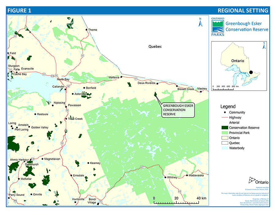
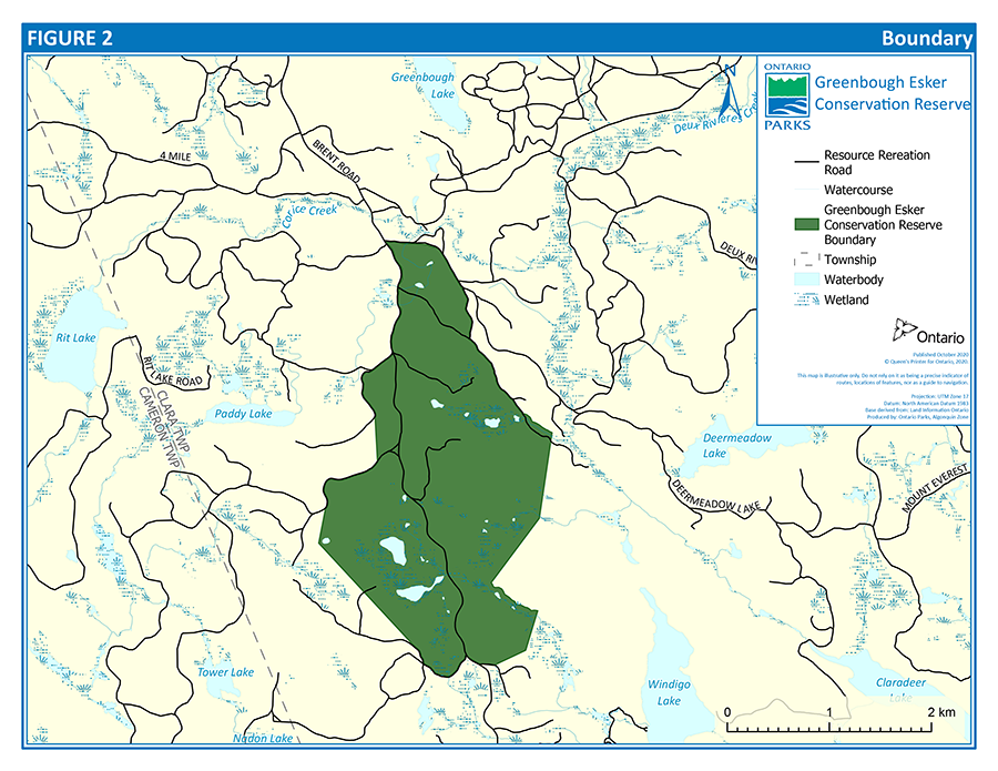
Greenbough Esker Conservation Reserve encompasses 552 hectares of land within Clara Township in the County of Renfrew (concession 5, lots 3 to 7, concession 6, lots 3 to 9, concession 7, lots 4 to 10, and concession 8, lots 6 to 9). The site lies approximately 7 km south of Deux Rivières and only 2 km north of Algonquin Provincial Park (see Figure 1 and Figure 2).
The Greenbough Esker was first recognized as a significant life science site by Daniel Brunton (1991) during his work on the Life Science Inventory for Ecodistrict 5E-10 (formerly referred to as Ecological Site District 5-10). Brunton identified a portion of the esker as a "provincially significant upland forest and wetland complex". The esker was also identified as a regionally significant earth science feature by Constance Spek (1992) as it is the largest esker in central Ontario and probably marks one of the last major channels for glacial meltwater when the last continental ice sheet withdrew from this area.
In 1991, in accordance with Ministry of Natural Resources (MNR) policy, much of the esker was designated a Candidate Area of Natural and Scientific Interest (ANSI) and all resource management activities within the Candidate ANSI (i.e. timber harvesting, aggregate extraction, road re-alignment) were suspended.
The Ministry of Natural Resources determined that an ANSI management plan should be prepared to identify an appropriate boundary of the ANSI and determine how resources within the ANSI should be managed and significant features protected.
Prior to preparation of the management plan, Dr. W. Crins (1995) completed a more detailed life science evaluation of the ANSI. Dr. Crins identified the location of a provincially significant core area and recommended its protection. The boundary of this conservation reserve is approximately the same as this "core" area.
A focus group representing various local interests was formed in October 1995 to advise MNR on the management plan for the ANSI area and provide local input into various resource management issues. The ANSI management plan attempts to address the interests of resource users while providing for the long-term protection of significant earth and life science values within a unique and fragile ecosystem. The ANSI Management Plan was approved in 1997 and provides management direction for the area of the ANSI outside the conservation reserve. It also provided valuable guidance and background information which contributed to the development of this management plan.
Following the development of the ANSI Management Plan the core management area was regulated as a conservation reserve. The section regulated was identified through Ontario’s Living Legacy Land Use Strategy for its unique values, as it is a large and intact earth and life science feature in Ecodistrict 5E-10.
This management plan was approved in 2003 and updated in 2021 to ensure direction for Greenbough Esker Conservation Reserve reflects the current status of the conservation reserve, as well as current provincial policy and legislation.
1.1 Planning context
The Provincial Parks and Conservation Reserves Act, 2006 (PPCRA) states that a management plan must be prepared for each conservation reserve in Ontario. This management plan meets that requirement.
This management plan has been updated to ensure consistency with all relevant legislation and provincial policies, including the PPCRA, Ontario Provincial Parks: Planning and Management Policies, 1992 Update (MNR 1992) and Ontario’s Living Legacy Land Use Strategy (MNR 1999). It is intended to guide conservation reserve management for the next 10 years.
1.1.1 Boundary consultation
Prior to the finalization of the boundaries of Greenbough Esker Conservation Reserve, Pembroke District MNR staff sent out boundary consultation packages to potentially affected stakeholders (adjacent landowners, resource users, municipalities, interest groups, and organizations), inviting comment on the proposed boundaries. Boundary consultation packages were also sent out to provincial interest groups and organizations. In addition, public notices were placed in local newspapers.
There were no significant issues raised during public consultation and only four responses were received.
In 2006 the conservation reserve was established by regulation under the PPCRA.
1.2 Ecological integrity
In the PPCRA, one of the guiding principles for conservation reserve planning and management is maintenance of ecological integrity shall be the first priority, and restoration of ecological integrity shall be considered.
An ecosystem has ecological integrity when:
- it has all the parts (both living and non-living) that you would expect to find
- natural functions and rates of change are happening normally
This management plan identifies site-specific management policies and actions intended to maintain or, where possible, restore ecological integrity.
Map 1: Round Lake Provincial Park Regional Context. This nature reserve class park is approximately 25 kilometres northwest of Parry Sound, Ontario.
Map 2: Round Lake Provincial Park Regional Context. This nature reserve class park is approximately 25 kilometres northwest of Parry Sound, Ontario.
Map 3: Round Lake Provincial Park Regional Context. This nature reserve class park is approximately 25 kilometres northwest of Parry Sound, Ontario.
1.3 Survey information
This section provides an overview of the inventories completed, their level of detail and any further inventory work required.
| Survey level | Earth sciences | Life sciences | Cultural | Recreational |
|---|---|---|---|---|
| Reconnaissance | Yes | Yes | n/a | n/a |
| Detailed | Yes | No | No | Yes |
| Requirement | No | Yes | No | No |
2.0 Values
This conservation reserve is located within Ecodistrict 5E-10. Values include earth science, life science and recreational features.
2.1 Earth science
2.1.1 Representation
Earth science values are focused on features (bedrock and surficial) that represent the chronology of earth history in the province (Davidson, 1981).
The Greenbough Esker was formed during downwasting of the final ice sheet during the Late Wisconsinan. The esker marks one of the final major channels for glacial meltwater during the retreat of the last continental ice sheet. The large size of the esker indicates that the area may have drained the main ice mass and is therefore considered regionally significant (Spek, 1992).
The last episode of glaciation probably began in this area about 80,000 years ago during the Guildwood Stadial (Ford, 1986). It is believed that the area was continually occupied by ice until the late Wisconsinan. Based on geological mapping of Algonquin Provincial Park (Ford et al., 1984), this area was free of ice between 10,000 and 15,000 years ago (Ford, 1986).
The Greenbough Esker is described by Chapman (1975, p.7) in the Physiography of the Georgian Bay-Ottawa Valley Area as "the largest esker in the whole region" (Georgian Bay, Ottawa Valley region). The esker is widest at the north end near Deux Rivières (0.8 km wide and 23 metres high) and is comprised mainly of sand. The central and southern portion of the esker from Greenbough Lake to the wetlands south of Corice Creek, best displays the classic "snake like" form. The peatlands, which have developed adjacent to the esker, formed where remnant ice blocks left kettle depressions in the earth (Brunton, 1991).
North of Windigo Lake the meltwater channel within the ice appears to have divided with part of the flow draining to the southwest (Greenbough route) and the remainder to the south east through Windigo, Allan and Depot lakes.
Disintegration of the ice front may have disrupted the deposit and resulted in isolated piles of material south of this conservation reserve. Small esker ridges and kame deposits are disrupted by pockets of organic material and alluvial deposits along the North River. The esker terminates near the north end of Wabamimi Lake in Algonquin Provincial Park (Spek, 1992).
2.1.2 Bedrock geology
This conservation reserve is located within the Algonquin Terrane (faulted bounded body of rock), Central Gneiss Belt of the Grenville Structural Province of the Canadian Shield. The underlying bedrock in the reserve consists of felsic granite, gneiss and migmatite. There is no exposed bedrock within the reserve.
The Grenville Structural Province is the product of thrusting and imbrication of the crust (Canadian Shield) to the northwest as it collided with a continental landmass to the southeast. This orogeny (mountain building event) occurred more than 1000 million years ago, ending more than 500 million years of crustal evolution.
2.1.3 Surficial geology
The surficial geology of the reserve is comprised of shallow morainal deposits of clay, sand, gravel and boulders as well as glaciofluvial deposits. The dominant feature in the reserve is part of an ice-contact esker/valley train outwash complex called the Greenbough Esker. This esker is at least 39 km long extending from the reserve area into Québec and traverses the reserve in a north-south orientation. More recent organic deposits of peat are also present.
2.1.4 Significance
There is no bedrock exposure in the reserve. The surficial geological features within the reserve include an esker/valley train outwash complex that is scarce in southern Ontario with few other examples in the protected area system giving it regional significance.
2.1.5 Pressure
Aggregate extraction has occurred at several locations along the route of the esker just north of the reserve and is the main threat to the integrity of the total landform.
2.2 Life science
Crins (1995) described the conservation reserve as a relatively intact forest dominated by white pine (Pinus strobus), red pine (Pinus resinosa), and jack pine (Pinus banksiana), in various combinations. Other species occurring in association with the pines include other conifers and intolerant hardwoods, such as balsam fir (Abies balsamea), white spruce (Picea glauca), black spruce (Picea mariana), large-toothed aspen (Populus grandidentata), trembling aspen (Populus tremuloides), and white birch (Betula papyrifera) with northern red oak (Quercus rubra) as a less frequent associate.
These upland forests have been identified as specific ecosites (forest types) as described in the Forest Ecosystems of Central Ontario (Chambers et al. 1997) by Merchant (2001). In upland sites on the esker forests were typed as ES11 (White Pine-Red Pine) and ES12 (Red Pine), with less frequent ES13 (Jack Pine-White Pine-Red Pine). Stands with red oak and/or intolerant hardwoods were identified as ES14 (White Pine-Largetooth Aspen-Red Oak). Additionally, a small area of pine plantation is found in the north end of the reserve.
Off the esker, on sandy shallow to deep tills, are mid-successional mixedwoods, described as ecosite ES27 (Sugar Maple-White Birch-Poplar-White Pine).
The reserve also contains peatlands or kettle bogs associated with the flanks of the esker which developed in depressions left over from melted blocks of glacial ice. Crins (1995) described these as peatlands consisting of sphagnum mats that support varying vegetation types, from open mats with herbaceous cover dominated by sedges, to areas dominated by ericaceous shrubs, and stunted black spruce and tamarack (Larix laricina).
2.2.1 Representation
Greenbough Esker is located on two landform types (Glaciofluvial Esker-Kettle Terrain and Precambrian Intermediate to Acidic Bedrock) and 19 vegetation types (using the provincial Forest Resource Inventory for vegetation data) with a resulting combination of 33 Landform/Vegetation (L/V) Associations.
Thirteen of these L/V Associations, roughly accounting for twenty percent of the reserve, are critical to representation in Ecodistrict 5E-10 (Table 2).
| Landform | Vegetation type | Area (ha) |
|---|---|---|
| Glaciofluvial Esker-Kettle Terrain | Jack-Red-White Pine | 0.18 |
| Glaciofluvial Esker-Kettle Terrain | Black Spruce-Tamarack Mixed | 0.25 |
| Glaciofluvial Esker-Kettle Terrain | Mixed Tolerant Hardwoods | 0.88 |
| Glaciofluvial Esker-Kettle Terrain | White Cedar | 1.31 |
| Glaciofluvial Esker-Kettle Terrain | Conifer Swamp/Fen/Bog | 1.5 |
| Glaciofluvial Esker-Kettle Terrain | White Spruce | 2.01 |
| Precambrian Intermediate to Acidic Bedrock | Tamarack Dominated | 2.44 |
| Glaciofluvial Esker-Kettle Terrain | Exposed Rock | 3 |
| Glaciofluvial Esker-Kettle Terrain | Tamarack Dominated | 3.5 |
| Precambrian Intermediate to Acidic Bdrck | Black Spruce-Tamarack Mixed | 6.44 |
| Glaciofluvial Esker-Kettle Terrain | Jack Pine-Spruces-Balsam Fir | 8.12 |
| Glaciofluvial Esker-Kettle Terrain | Jack Pine Mixedwoods | 30.19 |
| Glaciofluvial Esker-Kettle Terrain | Jack Pine (pure) | 52.06 |
2.2.2 Condition
Despite heavy logging activity at the turn of the century north of the conservation reserve, forests in the central portion of the esker within the conservation reserve, remain relatively intact. Some of the white and red pine stands in the area are 100-120 years and older. In the north end of the reserve, some of the pine was harvested in the 1970's using the uniform shelterwood system. Planting of jack, red and white pine and subsequent manual tending occurred in the 1980's. Planting of red pine also occurred in a small borrow pit in the southern end of the reserve some time in the 1990’s (Merchant 2001).
The southern portion of the reserve is transected by Brent Road, resulting in some fragmentation of the reserve. Merchant (2001) noted some trampling in areas where white-fringed orchid was found, and that garbage left by recreational users was occasionally an issue.
Overall Greenbough Esker Conservation Reserve can be considered to be in good condition.
2.2.3 Diversity
Thirty-three different Landform/Vegetation Associations have been identified in Greenbough Esker Conservation Reserve, although roughly two-thirds of the reserve is represented by upland forests of red, white and jack pine. There has been no formal faunal inventory, however, there is ample evidence of wildlife including bear, moose, waterfowl and various bird species.
Overall the diversity of the site would be considered to be fair to moderate, particularly considering its size.
2.2.4 Ecological considerations
The kettle lakes and wetlands within the reserve represent headwater areas for two tertiary level watersheds. Wetlands in the north part of the reserve drain north, through Deux Rivières Creek to the Ottawa River. Wetlands to the south of the reserve drain south through Windigo Lake to the Petawawa River. No rivers or streams flow into the conservation reserve.
The boundary of this conservation reserve is largely delineated by logging roads for the Nipissing Forest Management Unit.
Brent Road, an access road to Algonquin Provincial Park, runs along the west boundary in the northern portion of the reserve and through the middle of the reserve in the southern portion; thousands of vehicles pass through every year. This road may represent a barrier to movement for some wildlife species. Traffic on the road could also represent a source of non-native and invasive species.
This reserve is used in localized areas for recreation, which is limited to seasonal hunting activities and nature appreciation.
2.2.5 Special features
The peatlands provide habitat for several uncommon to provincially rare species (Crins, 1995) including; few-flowered sedge (Carex pauciflora), white fringed orchid (Platanthera blephariglottis), yellow-eyed grass (Xyris montana) and nut grass (Scheuchzeria palustris). Several regionally or locally rare species were also reported by Brunton (1991), including cord sedge (Carex chordhorrizal), mud sedge (Carex limosa), small bur-reed (Sparganium natans) and Virginia chain-fern (Woodwardia virginica).
2.2.6 Significance
Greenbough Esker Conservation Reserve contains thirteen Landform/Vegetation Associations that are critical to representation in Ecodistrict 5E-10. Some of these associations are the best or only examples within the Ecodistrict and the collection of L/Vs as a whole is not represented elsewhere in the Ecodistrict. As such, Greenbough Esker Conservation Reserve is considered to be provincially significant (Brunton 1991, Crins 1995).
2.3 Cultural heritage
Specific cultural heritage values within Greenbough Esker Conservation Reserve have not been identified. An evaluation of cultural heritage values may be undertaken.
2.4 Outdoor recreation
Greenbough Esker Conservation Reserve is visited primarily by those travelling to Algonquin Provincial Park or Windigo Lake access point. It is also used occasionally for moose and black bear hunting (Moore, 2002).
3.0 Resource management policies
3.1 Land tenure
Greenbough Esker Conservation Reserve encompasses one parcel of land 552 hectares in size, within Clara Township in the County of Renfrew (concession 5, lots 3 to 7, concession 6, lots 3 to 9, concession 7, lots 4 to 10, and concession 8, lots 6 to 9). The conservation reserve is surrounded by Crown land.
There are currently no existing licences, leases or permits associated with this site. New land dispositions will not be allowed within the conservation reserve.
Brent Road is a major right-of-way through the reserve. It follows the esker closely from Deux Rivières south to Windigo Lake where it turns westerly into Algonquin Provincial Park.
3.2 Existing/proposed development
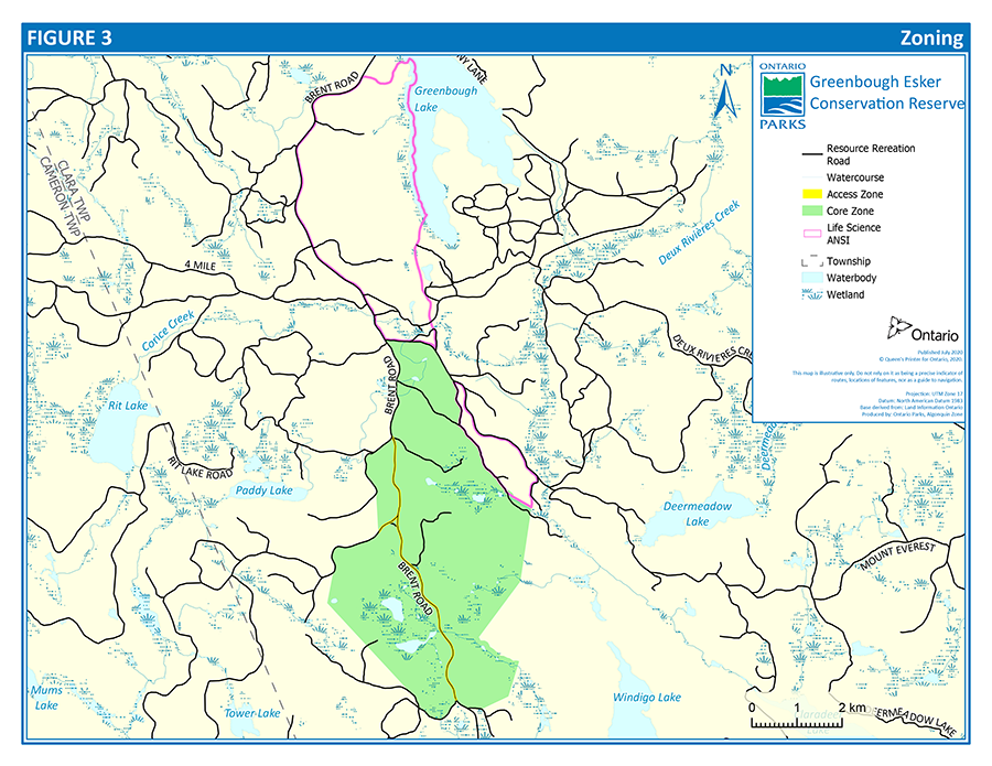
Access to this conservation reserve is available from existing roads and trails in the access zone as shown in Figure 3. The conservation reserve boundary is offset seven metres from the centre line of the roads bordering it.
The Greenbough Esker ANSI Management Plan included a goal of completing the necessary road work to resolve the traffic and safety concerns for the Brent Road. In November and December 1996, a section of the road, now within the boundaries of Greenbough Esker Conservation Reserve, was upgraded by the Algonquin Forestry Authority. Several corners were straightened, drainage was improved and the road re-surfaced. All work was carried out in such a way that impacts on earth and life science features were negligible. Regular maintenance of resource access roads may continue, however there is no anticipated future realignment or widening work within the conservation reserve boundary.
The Algonquin Forestry Authority, MNRF, MECP, logging companies or individuals with tenure in the area may carry out road maintenance provided it does not result in an alteration of the right-of-way width, subject to applicable legislation and policies.
New trails are not permitted.
Existing trails outside of the identified access zone will be designated and signed for non-motorized use only, except by authorized persons. Any improvements to alignment of existing trails or roads which border the conservation reserve shall be done outside of the conservation reserve with the abandoned roadbed rehabilitated.
Facility infrastructure and development for recreational and/or educational purposes may be considered in the future if there is a demonstrated demand for such facilities. Updates to this management plan may be required.
3.3 Recreational activities
The recreational value of the site is primarily local in nature, being mostly restricted to boundary roads and trails, with limited interior activities such as hunting and occasional nature viewing excursions.
Mechanized travel, including by all-terrain vehicles (ATVs) and snowmobiles, is permitted only on existing, approved roads or trails within the access zone (Figure 3). ATV use off existing roads or trails is permitted only for the direct retrieval of game harvested in accordance with the Fish and Wildlife Conservation Act, 1997 (FWCA) or the Migratory Birds Convention Act, 1994.
Most recreational activities that have traditionally been enjoyed in this area are permitted provided they pose no threat to the natural ecosystems and features protected by the conservation reserve. Permitted uses include wildlife viewing, hiking, snowshoeing, cross-country skiing, and exploring. Sport fishing and hunting are permitted in accordance with regulations under the FWCA.
The conservation reserve shall be posted for "No Camping. No off-road ATV's or Snowmobiles".
3.4 Industrial activities
The following activities are prohibited in Greenbough Esker Conservation Reserve:
- commercial timber harvest
- generation of electricity
- extracting aggregate, topsoil or peat
- prospecting, staking mining claims, developing mineral interests or working mines
- other industrial uses
3.5 Indigenous interests
Greenbough Esker Conservation Reserve is located within lands encompassed by the Williams Treaties Clause 1, Robinson-Huron Treaty and Algonquins of Ontario settlement area. The lands also are within the Métis Nation of Ontario Region 5, which includes the Mattawa Lake Nipissing Traditional Harvest Area.
The lands within the Greenbough Esker Conservation Reserve have been and continue to be used by Indigenous peoples for traditional and ceremonial purposes.
3.6 Natural resource stewardship
3.6.1 General
This conservation reserve will be managed with an emphasis on ensuring that natural ecosystems and processes are not negatively affected by current and future activities. Applications for specific uses will be carefully studied and reviewed. Ontario Parks, its partner organizations, and/or the proponents may undertake such studies.
3.6.2 Vegetation and fire management
The conservation reserve will be managed by allowing natural ecosystems, processes and features to operate normally, with minimal human interference or alteration.
Where commercial forest management is proposed adjacent to the conservation reserve, a 30 metre wide modified management zone shall be implemented where the canopy closure shall be maintained at 50% or greater. Clearcut harvesting is not permitted within the modified management areas. Also, broadcast spraying of herbicides is not permitted within 120 metres of the conservation reserve. Prescribed burning is not permitted within the conservation reserve.
Conservation reserve policy states that forest fire protection will be carried out as on surrounding public lands, unless it is determined through management planning that another approach should be undertaken. The Ministry of Natural Resources and Forestry (MNRF) has an agreement with the Townships of Head, Clara and Maria, for fire response on Crown land in the Pembroke area including Greenbough Esker Conservation Reserve, where their ability permits.
Additional life science information should be acquired as resources and time permit.
3.6.3 Alien and invasive species
Alien species are plants, animals and microorganisms introduced by human actions outside their natural past or present distribution. These species may originate from other continents, countries or provinces, or from other parts of Ontario.
Invasive species are alien species that are harming, or likely to harm, the natural environment in Ontario or parts of Ontario. Alien and invasive species will be addressed in a manner consistent with the Invasive Species Act, 2015, regulations and guidelines, Ontario’s Invasive Species Strategic Plan, Procedural Guideline B – Test of Compatibility (Appendix 1), and other relevant documents or best practices.
Where possible, Ontario Parks will work to eradicate or control invasive species in Greenbough Esker Conservation Reserve. Invasive species control will aim to reduce or prevent impacts to native species, biodiversity, ecosystem function, and recreational opportunities. Control activities will be adapted based on the best available information.
Programs may be developed to control forest insects and diseases in the proposed conservation reserve where these threaten significant natural heritage, aesthetic, or economic values. Where control is desirable, it will be directed as narrowly as possible to the specific insect or disease. The methods selected will be subject to the requirements of Procedural Guideline B – Test of Compatibility (Appendix 1).
3.6.4 Wildlife management
Greenbough Esker Conservation Reserve is within the limits of baitfish harvesting area PE0106, registered trapline areas PE033 and PE034, and Bear Management Area PE-48-008. Fur and baitfish harvesting will continue to be managed through the current licence systems. Existing baitfish harvesting and commercial fur harvesting are permitted to continue within the Greenbough Esker Conservation Reserve unless there are demonstrated conflicts. New baitfish and fur harvesting operations may be considered subject to the Test of Compatibility (see Appendix 1).
Hunting within the conservation reserve is permitted and will be guided by the FWCA and regulations.
Portable hunting blinds or portable tree stands may be placed in this conservation reserve no more than seven days prior to the beginning of the hunting season prescribed for Wildlife Management Unit 48 and must be removed no more than seven days after the end of the hunting season.
The following activities are not permitted:
- new or existing fur harvesting cabins
- permanent tree stands
- private recreation camps
- new or existing outpost camps or tourism facilities
- new commercial non-resident bear hunting operations
Commercial food harvesting operations may be considered within the proposed reserve.
3.6.5 Species at risk
Species at risk and their habitats will be protected in a manner consistent with the Endangered Species Act, 2007, regulations and guidelines, and other relevant policy or best practices.
The reserve may undertake management actions for species at risk, as supported by research and directed through approved recovery strategies and government response statements or other species-specific management plans.
3.7 Cultural resource stewardship
Cultural heritage values will be identified, assessed and managed in accordance with existing applicable legislation and policies. If cultural heritage values are discovered, Ontario Parks will follow requirements outlined in relevant cultural heritage policy.
3.8 Visitor services
Visitor services (such as interpretation, access and signage) associated with the site include a brief informative fact sheet that was developed during the public consultation phase in 2000 for boundary regulation of the site. Additional information about this conservation reserve is also available through the Crown Land Use Policy Atlas. Signage will be posted on the Brent Road at north and south limits of the conservation reserve advising of restricted uses.
Visitor information will be provided on an inquiry basis only and will deal with the basic level of information with respect to access, natural heritage appreciation, recommended activities, and boundaries.
3.9 Research
Ontario Parks may carry out inventories and monitoring to inform conservation reserve management decisions.
Non-destructive research by qualified individuals will be encouraged to provide a better understanding of the natural values protected by the Greenbough Esker Conservation Reserve and to advance protection, planning and management.
In general, research will be encouraged to:
- provide a better understanding of the natural values protected by Greenbough Esker Conservation Reserve
- monitor impacts of recreational use of the site
- advance protection, planning and management of the conservation reserve
Any external party who wishes to carry out research in Greenbough Esker Conservation Reserve must obtain a research authorization letter from the conservation reserve manager. Researchers may also need to obtain additional permits or approvals (e.g. ESA permits). Additionally, authorization is required for the removal of any natural or cultural specimen.
The establishment of permanent plots, observation points or facilities must also be approved and be compatible with the conservation reserve protection objective. Any site disturbed by research activities must be rehabilitated as closely as possible to its previous state.
4.0 Implementation
Administrative responsibility for Greenbough Esker Conservation Reserve lies with Ontario Parks, Ministry of the Environment, Conservation and Parks.
Ontario Parks will continue with the custodial care of this conservation reserve and will also seek out partnerships where appropriate. Implementation of this management plan will primarily involve monitoring activities to ensure adherence to the management guidelines.
Implementation priorities include:
- ensuring compliance to prescribed management policies posting signage regarding restricted uses
- undertaking additional life science inventory and research
- providing visitor information on the Ontario Parks website and additional information upon request
- providing ongoing education to resource users with respect to resource and land stewardship values (e.g. engaging in partnership opportunities, working with adjacent landowners, municipalities, etc.) in order to provide long term recreational opportunities and maintain the ecological integrity of the site
Implementation of actions may be subject to:
- other applicable legislation and policies (e.g. environmental assessments)
- site planning
- the availability of financial and human resources
5.0 Examination and adjustment of the management plan
Greenbough Esker Conservation Reserve Management Plan will be examined in accordance with the provisions of the PPCRA to determine whether it is still relevant, effective and current, or if adjustments are needed. In circumstances where this management plan is not providing sufficient direction, or to address specific issues or pressures, it can be examined prior to the next scheduled examination.
Adjustment to this management plan will be in accordance with the Ontario’s Protected Areas Planning Manual and Guidelines, or other relevant policy.
6.0 References
Brunton, D. F. 1991. Greenborough (Greenbough) Esker Candidate ANSI, Area of Natural and Scientific Interest – Life Science Checksheet, Ministry of Natural Resources, Parks and Natural Areas Policy Branch. Pp. 141-146 in Brunton, D.F. 1991. Life Science Areas of Natural and Scientific Interest in Site District 5-10. Parks and Recreation Areas Section, Ontario Ministry of Natural Resources Algonquin Region, Huntsville.
Chapman, L. J. 1975. The Physiography of the Georgian Bay-Ottawa Valley Area of Southern Ontario. Division of Mines, GR 128.
Chapman, L.J., and Putnam, D.F. 1984: The Physiography of Southern Ontario; Ontario Geological Survey, Special Volume 2, 270p.
Crins, W. J. 1995. Greenbough Esker (Site District 5E-10) Brief Summary of Features and Assessment of Significance with maps, Ministry of Natural Resources, Huntsville.
Davidson R. J. 1981. A framework for the conservation of Ontario’s earth science features. Ontario Ministry of Natural Resources, Toronto.
Endangered Species Act, 2007, S.O. 2007, c. 6
Ford, M. J. 1986. Technical Background Information Report: Specific Areas of Earth Science Significance within Algonquin Provincial Park, Ontario Geological Survey, unpublished report.
Invasive Species Act, 2015, S.O. 2015, c. 22
Merchant, B. 2001. Natural Heritage Area- Life Science Checksheet Greenbough Esker – C130. Ontario Ministry of Natural Resources, Pembroke District.
Noble T. W. 1983. Biophysiographic Analysis of Site Region 5E. Central (Algonquin) Region, Ontario Ministry of Natural Resources.
Ministry of Natural Resources. 1992. Ontario Provincial Parks: Planning and Management Policies, 1992 Update. Provincial Parks and Natural Heritage Policy Branch. Toronto: Queen’s Printer for Ontario.
OMNR 1983. Pembroke District Land Use Guidelines . Pembroke District, Algonquin Region, Ontario Ministry of Natural Resources
OMNR 1997. Greenbough Esker Area of Natural and Scientific Interest Management Plan. Pembroke District.
OMNR 1999. Ontario’s Living Legacy, Land Use Strategy, July 1999. Ontario Ministry of Natural Resources, Peterborough.
Ministry of Natural Resources. 2005. A Class Environmental Assessment for Provincial Parks and Conservation Reserves. Environmental Assessment Report Series. Peterborough: Queen’s Printer for Ontario.
Ministry of Natural Resources. 2006. A Technical Guide for Cultural Heritage Resources for Projects Planned Under the Class Environmental Assessment for Ministry of Natural Resources Resource Stewardship and Facility Development Projects and the Class Environmental Assessment for Provincial Parks and Conservation Reserves. Peterborough: Queen’s Printer for Ontario.
Ministry of Natural Resources and Forestry. 2014. Ontario’s Protected Areas Planning Manual and Guidelines: 2014 Edition. Peterborough: Queen’s Printer for Ontario. 33 pp.
Ministry of Natural Resources and Forestry. 2018. Ontario Parks Operating Standards. Peterborough.
Ministry of the Environment, Conservation and Parks and Ministry of Natural Resources and Forestry. 2019. Fire Management Policy for Provincial Parks and Conservation Reserves, PAM 7.02, (draft).
Moore, Tracy. 2002. Recreation Inventory Report Greenbough Esker Conservation Reserve (130).
Ontario Heritage Act, R.S.O. 1990, c. O. 18
Provincial Parks and Conservation Reserves Act, 2006, S.O. 2006, c. 12
Rivard, L.A., Blackburn, C.E., 2003. Earth Science Checksheet Greenbough Esker Conservation Reserve; Ontario Ministry of Natural Resources, 3p.
Spek, C. M. 1992. Greenbough Lake Esker. Area of Natural and Scientific Interest – Earth Science Checksheet, Ministry of Natural Resources, Parks and Natural Areas Policy Branch.
Webster, D.N. 2017. A Framework for the Conservation of Ontario’s Earth Science Features, Ontario Ministry of Natural Resources, 390 p.
Appendix 1: Procedural guideline B – land uses – test of compatibility (PL procedure 3.03.05)
The Conservation Reserve policy provides broad direction with regard to the permitted uses. The policy provides only an indication of the variety of uses that will be considered acceptable in Conservation Reserves. The only caution is that "any new uses, and commercial activities associated with them, will be considered on a case by case basis, and, they must pass a test of compatibility to be acceptable."
What does a 'test of compatibility' mean? An examination of this must start from the premise of why an area is set aside – specifically, its representative natural heritage values. Criteria are then identified to guide compatibility considerations. These criteria apply to the long-term acceptability of both existing uses and new uses.
1. Conformity to SCI/RMP: SCI describes values for which an area has been set aside and the range of appropriate uses that will be permitted in the area. SCI may also speak to the acceptability of other 'new' uses currently not occurring in the area.
The first 'test' is: "do proposed new land uses and/or commercial activities conform to the direction of the SCI/RMP for the Conservation Reserve? Would the new use(s) depart from the spirit of appropriate indicator land uses in the SCI/RMP?"
2. Impact Assessment: If the proposed use(s) pass test 1 it is important to determine their impact on the area before they are approved. This should include the following:
- Impact on natural heritage values: "will the new use(s) impact any natural values in the area? If so how and to what degree? Is it tolerable?"
- Impact on cultural values: "will the new use(s) impact an historical or archaeological values in the area?"
- Impact on research activities: "will the new use(s) affect research activities in the area?"
- Impact on current uses: "will the new use(s) have any negative impact on the array of current uses?"
- Impact on area administration: "will the new use(s) increase administrative costs and/or complexity?" (For example, the cost of area monitoring, security and enforcement).
- Impact on accommodating the use outside the Conservation Reserve: "Could the use(s) be accommodated as well or better outside the Conservation Reserve?"
- Impact on socio-economics of the area: "will the new use(s) affect the community (ies) surrounding the area in a positive or negative way?" (For example, will the new use make an area less remote thereby affecting a local tourism industry that is dependent on the area’s remoteness for its appeal?"
- Impact on area accessibility: "does the new use(s) give someone exclusive rights to the area or a portion of the area to the exclusion of other existing uses?"
Indicator uses for conservation reserves
| Activity | Generic OLL policy permitted? (Yes, No, Maybe) existing | Generic OLL policy permitted? (Yes, No, Maybe) new | Specific application in Greenbough Esker Conservation Reserve existing | Specific application in Greenbough Esker Conservation Reserve new |
|---|---|---|---|---|
| Commercial timber harvest | No | No | No | No |
| Cutting of trees by leaseholders and property owners for fuelwood and small-scale uses | Maybe | Maybe | Maybe | Maybe |
| Timber salvage/sunken log retrieval | Maybe | Maybe | Maybe | Maybe |
| Mineral exploration | No | No | No | No |
| Mining | No | No | No | No |
| Extraction of peat, soil, aggregate, other materials | No | No | No | No |
| Forest renewal | Maybe |
Maybe |
Maybe |
Maybe |
| Hydro power generation | No | No | No | No |
| Communications corridors | Yes | No |
Yes | No |
| Energy transmission corridors | Yes | No |
Yes | No |
| Transportation corridors | Yes | No |
Yes | No |
| Resource access roads | Maybe |
Maybe |
Maybe |
Maybe |
| Private access roads | Yes | No |
Yes | No |
| Activity | Generic OLL policy permitted? (Yes, No, Maybe) existing | Generic OLL policy permitted? (Yes, No, Maybe) new | Specific application in Greenbough Esker Conservation Reserve Existing | Specific application in Greenbough Esker Conservation Reserve New |
|---|---|---|---|---|
| Sport fishing | Yes | Yes | Yes | Yes |
| Sport hunting | Yes | Yes | Yes | Yes |
| Facility development | Maybe | Maybe | Maybe | Maybe |
| Non-trail snowmobiling | Maybe |
Maybe |
Maybe |
Maybe |
| Non-trail ATV use | Maybe |
Maybe |
Maybe |
Maybe |
| Motorized boating | Yes | Yes | Yes | Yes |
| Camping | Maybe | Maybe | Yes | Yes |
| Trails: hiking, snowmobiling, cycling, horse riding, cross-country skiing | Yes | Maybe | Yes | Maybe |
| Private recreation camps | Yes |
No | Yes |
No |
| Activity | Generic OLL Policy Permitted? (Yes, No, Maybe) existing | Generic OLL Policy Permitted? (Yes, No, Maybe) new | Specific application in Greenbough Esker Conservation Reserve existing | Specific application in Greenbough Esker Conservation Reserve new |
|---|---|---|---|---|
| Fishing | Yes |
Maybe | Yes |
Maybe |
| Bait-fish harvesting | Yes |
Maybe | Yes |
Maybe |
| Commercial fur trapping | Yes |
Maybe | Yes |
Maybe |
| Trapping cabin | Yes | No | Yes | No |
| Out-post camps/tourism facilities | Maybe |
Maybe |
Maybe |
Maybe |
| Commercial bear hunting (tourist operators) | Yes | No | Yes | No |
| Wild rice harvesting | Yes |
Maybe | Yes |
Maybe |
| Food harvesting | Maybe | Maybe | Maybe | Maybe |
| Activity | Generic OLL policy permitted? (Yes, No, Maybe) existing | Generic OLL policy permitted? (Yes, No, Maybe) new | Specific application in Greenbough Esker Conservation Reserve existing | Specific application in Greenbough Esker Conservation Reserve new |
|---|---|---|---|---|
| Resource inventorying | Yes | Yes | Yes | Yes |
| Resource monitoring | Yes | Yes | Yes | Yes |
| Fire protection | Yes | Yes | Yes | Yes |
| Insect and disease | Maybe | Maybe | Maybe | Maybe |
| Featured species management | Maybe | Maybe | Maybe | Maybe |
| Activity | Generic OLL policy permitted? (Yes, No, Maybe) existing | Generic OLL policy permitted? (Yes, No, Maybe) new | Specific application in Greenbough Esker Conservation Reserve existing | Specific application in Greenbough Esker Conservation Reserve new |
|---|---|---|---|---|
| Research | Yes | Yes | Yes | Yes |
| Collecting | Maybe |
Maybe |
Maybe |
Maybe |
| Food gathering | Yes | Yes | Yes | Yes |
| Land disposition | Yes |
Maybe |
No |
No |
| Habitat management for wildlife | Maybe |
Maybe |
Maybe | Maybe |
Appendix 2: Management planning history
| Approval date | Examination or type of adjustment | Examination outcome | List of supporting documents |
|---|---|---|---|
| December 14, 2017 | Examination | Administrative update |
|
| March 15, 2021 | Administrative update | n/a |
|
Footnotes
- footnote[1] Back to paragraph If a new conservation reserve has been recently cut, companies have an obligation to proceed with renewal. It can be conducted where it will be of net benefit to the protected area and to, the greatest extent possible, it should be designed to replicate natural conditions.
- footnote[2] Back to paragraph The intent is to actively discourage these uses, but it is recognized that in some circumstances these will be no alternative; this will be determined through planning.
- footnote[3] Back to paragraph New private access roads, including additions to existing roads, will not be permitted except where there are previous commitments that were made prior to March 29, 1999. Such commitments will be subject to the completion of a public planning process.
- footnote[4] Back to paragraph Use may be permitted for the direct retrieval of game only.
- footnote[5] Back to paragraph Existing private recreation camps are eligible for enhanced tenure but not for the purchase of lands. A decision to grant enhanced tenure, or to transfer recreational camps will be addressed though a screening process.
- footnote[6] Back to paragraph Existing use permitted to continue, unless there are significant demonstrated conflicts. New operations can be considered, subject to the ‘test of compatibility.’
- footnote[7] Back to paragraph Existing authorized tourism facilities can continue unless there are demonstrated conflicts. The operators of tourism facilities can apply to upgrade tenure from LUP to lease. New tourism facilities can be considered during planning for a conservation reserve.
- footnote[8] Back to paragraph Must be part of an authorized research project.
- footnote[9] Back to paragraph Sale of lands is not permitted with the exception of some minor types of dispositions where it does not detrimentally affect the values an area is intended to protect. Renewals of existing leases or land use permits are permitted. Requests for transfer of tenure will be considered in the context of the SCI. New leases or land use permits will be allowed for approved activities.
- footnote[10] Back to paragraph A specific policy was not identified in the OLL Land Use Strategy, although specific management prescriptions will be identified in the context of an SCI.