Gull-Christina Conservation Reserve Management Statement
This document provides policy direction for the protection, development and management of the Gull-Christina Conservation Reserve and its resources.
Statement of Conservation Interest
Prepared for OMNR, Red Lake District
Joanne M. Stanley and Angie McLellan
OLL Interns
June 24, 2003
Approval statement
I am pleased to approve this Statement of Conservation Interest for the Gull-Christina Conservation Reserve.
This Statement of Conservation Interest provides guidance for the management of the Gull-Christina Conservation Reserve and the basis for the ongoing monitoring of activities. Should significant facility development or resource management be considered, or complex issues arise; requiring additional studies, a more detailed Conservation Reserve Management Plan will be prepared with full public consultation.
The public was widely "consulted" during the original regulation process for this site. Additional consultation is not required at this time, however, further consultation with the community of Cat Lake First Nation is required before this site can be regulated,
The Gull-Christina Conservation Reserve will continue to be managed by the Red Lake South Area, Red Lake District, Ministry of Natural Resources.
Signed by:
Graeme Swanwick
District Manager
Red Lake District
Date: July 17, 2003
Signed by:
Charlie Latter
Regional Director
Northwest Region
Date: July 22, 2003
1.0 Background information
The purpose of this document is to identify the natural heritage values of the Gull-Christina Conservation Reserve, as well as identify the type and extent of current recreational use on-site. A set of management guidelines defines the activities that may or may not be permitted, along with the overall management direction for the area. For more information on the basis for this Statement of Conservation Interest, please refer to the Conservation Reserves Policy and Procedure PL3.03.05.
| Name | Gull-Christina Conservation Reserve |
|---|---|
| Site Region / Site District | 3S – 4 |
| OMNR Administrative Region / District / Area | Northwest Region – Red Lake District – Red Lake South Area |
| Total Area (ha) | 1,889 ha |
| Regulation Date | Pending |
| First Nations | Nishnawbe-Aski First Nation’s Peoples, Treaty 9 - Cat Lake Traditional Use Area |
| Latitude / Longitude | 51°15'N / 92°01'W |
| Basemap | 557567, 557568, 556568, and 556567 |
| Forest Resource Inventory Stand Numbers | 95, 96, 126, 127, 128, 129, 130 and others (2000 inventory) |
| General Location Description | A boat launch to get into the river exists approximately 4 km down on the west side of Snake Bay Rd., off of Hwy 17. |
| Access | The Gull-Christina Conservation Reserve is largely inaccessible by road. The Wenasaga Road (primary forest access road) ends approximately 40km southwest of this site. The access is limited primarily to air or waterway (although there are no established canoe routes). |
Targets 1.1
This section provides a summary of the earth science, life science and cultural resource values as well as any present or possible recreational opportunities.
| Life Science Representation | The Gull-Christina Conservation Reserve includes representative vegetation of mixed deciduous and coniferous forests. Peatlands including treed wetland, conifer swamp, and open moderately rich fens are found. Evidence of summer caribou use is present. Young burn with open jack pine indicating potential winter habitat for caribou was identified. |
|---|---|
| Earth Science Representation | Most of the landforms in the Conservation Reserve consist of weakly broken bedrock, also present is organic deposits. A single phase of Precambrian massive granitic rock underlies the area. The Conservation Reserve includes ground moraine till and a prominent esker. |
| Cultural Resource Representation | No documented cultural heritage values have been identified. |
| Recreational Opportunities | Opportunities may exist for remote wilderness recreation with limited accessibility. Angling opportunities for sport fish exist. Activities with broad potential include exploration, hunting and nature study. |
1.2 Survey information
This section provides an overview of the completed inventories, their level of detail and any further inventories that are needed.
| Survey Level | Reconnaissance | Detailed | Additional Survey Required |
|---|---|---|---|
| Life Science | Completed Autumn 2001 | No | |
| Earth Science | Completed Summer 2001 | No | |
| Cultural | No | No | |
| Recreational Check Sheet | Completed Summer 2001 | No |
2.0 Values to be protected
This section provides a description of the key natural heritage values on the Gull-Christina Conservation Reserve, and their condition relative to past resource use and management activities and their sensitivity to future land use and management activities
2.1 Values identified on the site
| Life Science | The Gull-Christina Conservation Reserve includes representative vegetation of mixed deciduous and coniferous forests, young burns and caribou habitat. |
|---|---|
| Earth Science | Most of the landforms in the Conservation Reserve consist of weakly broken bedrock. Organic deposit, ground moraine and esker are also present. |
| Cultural | None Identified. |
| Aboriginal | Nishnawbe-Aski First Nation’s Peoples, Treaty # 9. |
| Tourism | One outpost camp, operated by Slate Falls Airways is located across from the south boundary of the Gull-Christina Conservation Reserve on the south shore of Christina Lake. |
| Recreational Fishing | There is potential for fishing on Gull Lake and Christina Lake, however, access is limited. Lake surveys indicate the presence of northern pike and walleye. |
| Recreational Hunting | The Gull-Christina Conservation Reserve may be used for moose and small game hunting, access is limited. |
| Mining | Low mineral potential; Conservation Reserve was withdrawn from staking. |
| Aggregates | No past or existing operations. |
| Forest Harvest | The Gull-Christina Conservation Reserve is part of the Trout Lake and Lac Seul Forest Management Units; unallocated within the respective Forest Management Plan areas and currently under interim protection until regulation. No harvest is anticipated in this area for the next 80 years (Trout Lake and Lac Seul Forest Caribou Habitat Mosaics 2004 - 2009) |
| Trapping | There is one registered trapline located within the Conservation Reserve. SL193 is active and permitted to continue. |
| Bear Management Area | There are no BMA's in the Conservation Reserve. |
| Commercial Fish | There are populations of fish species suitable for commercial fishing within the water bodies surrounding the Conservation Reserve however, no license is currently held. Although the Conservation Reserve falls within 3 commercial baitfish blocks, potential is limited and use unknown. |
2.2 Values to be protected
The intent of this Statement of Conservation Interest is to protect values by establishing management guidelines for existing and potential uses in this area, given the level of past disturbance and the nature of the existing features.
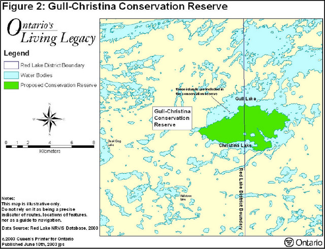
Major Representative Values: The Gull-Christina Conservation Reserve has critical representation of open and treed wetland on bedrock and significant representation of conifer on bedrock and some other LV-types for site 3S-4. The open peatland also represents a regionally significant calving area for woodland caribou. The esker observed at the low bluff on the southern shoreline of Gull Lake and on the three small islands may be of local significance. This esker is representative of the numerous eskers fanning out from the Agutua Moraine toward the Lac Seul Moraine.
Forest Values: The Gull-Christina Conservation Reserve is located between the Trout Lake Forest and the Lac Seul Forest and has been withdrawn from the Sustainable Forest License. The forested area will be protected from future harvest operations.
Recreational Values: The Conservation Reserve offers limited access (i.e. roads, navigable waters). There are no ongoing recreational development plans, however, there is a potential for remote fishing and hunting opportunities.
Tourism Values: The Gull-Christina Conservation Reserve has potential for ecotourism opportunities, although, access to the Conservation Reserve is limited.
3.0 Management guidelines
3.1 Land tenure
The Gull-Christina Conservation Reserve will remain Crown land. No new private dispositions (including Land Use Permits or Licences of Occupation) will be issued for the site.
3.2 Existing and proposed development
The earth science features and/or landforms within the Gull-Christina Conservation Reserve have not proven to be sensitive to natural impacts, however, the esker is one feature that is sensitive to cultural impact. The esker ridge is located along the south shore of Gull Lake and includes three small islands. To date there is no existing or proposed development within this Conservation Reserve. Development that would alter or disturb this site will not be allowed.
3.3 Recreational activities
Recreational activity is permitted, although, access is limited. There are no recreational trails on this site. The impact of recreational activities on the three islands will be assessed when the opportunity presents itself (through Fish and Wildlife enforcement patrols or outpost inspections) to determine further restrictions on this site. Angling opportunities for sport fish exist within the water bodies adjacent to this Conservation Reserve. Hunting in Conservation Reserves is also permitted.
3.4 Commercial activities
The Gull-Christina Conservation Reserve is part of the Trout Lake Forest Management Unit and the Lac Seul Forest Management Unit. The Conservation Reserve will be permanently removed from the Sustainable Forest Licence held by Weyerhaeuser Company Limited and Mackenzie Forest Products through the regulation process. An examination of the possible impact of activities on adjacent lands should be evaluated in the forest management planning process.
The Ministry of Northern Mines and Development (MNDM) has also withdrawn this site from all mineral exploration and extraction activities.
There is one registered trapline located within the Gull-Christina Conservation Reserve that is active and permitted to continue.
The Conservation Reserve is also included in a portion of an active commercial baitfish block and permitted to continue.
No other commercial activities exist in the area. No new activities, such as mining, aggregate or peat extraction, commercial logging, hydroelectric power development, utility corridors, highways or roads, will be permitted.
3.5 Aboriginal interests
Traditional land use in the Gull-Christina Conservation Reserve involves the Nishnawbe-Aski First Nation. This Statement of Conservation Interest does not intend to affect existing or future Aboriginal treaty rights.
3.6 Natural Resources Stewardship
3.6.1 Vegetation management
The Gull-Christina Conservation Reserve is located within the Trout Lake Forest and Lac Seul Forest Management Units and the Boreal Zone of the West Fire Region. Fire occurrences will be considered a high priority for action. In order to maintain the ecological integrity of this site, the role of fire must be considered. The Ministry of Natural Resources recognizes fire as an essential process in the maintenance and renewal of ecological sustainability and ecosystem health. Fire will occur naturally in designated areas of the Conservation Reserve. Fire and resource managers will identify those areas, and the specific conditions under which prescribed fires may be used to meet resource management objectives. Prescribed burning may be used, in accordance with Ministry of Natural Resources policy and guidelines to achieve resource management objectives within the Conservation Reserve.
Flexibility in suppressing low-risk fire occurrences within the Gull-Christina Conservation Reserve will also be evaluated through a more detailed local natural resource plan or fire management plan. Until a fire management plan is prepared all wildfires will be dealt with according to the Fire Management Objectives of the surrounding Fire Management Zone.
3.6.2 Fish and wildlife management
Existing Wildlife Management Unit and sport fishing regulations and their management activities will apply to facilitate the management of fish and wildlife in this Conservation Reserve. Through the forest management planning process wildlife habitat values within and adjacent to the Conservation Reserve will be identified and accommodated for through this process.
3.6.3 Landforms
The sensitive esker ridge within the Gull-Christina Conservation Reserve will be protected from any commercial activity.
3.7 Cultural Resources Stewardship
No management planning is required at this time based on existing information.
Cultural, historical and archaeological features were not identified when reviewing background information and research, nor were they identified during the site visit.
3.8 Client services
There are no established client services for the Gull-Christina Conservation Reserve at this time, nor are there any immediate plans for developing such client services. Information regarding the Gull-Christina Conservation Reserve is available from the Red Lake District Office.
3.9 Research
Non-destructive research related to the study of earth and life sciences will be encouraged in the Gull-Christina Conservation Reserve.
3.10 Marketing
No marketing activity is required at this time.
4.0 Implementation
Implementation of management guidelines is the responsibility of the Red Lake South Area Supervisor, Red Lake District. Any affected interest groups or clients will be immediately informed of proposed changes to this Statement of Conservation Interest.
5.0 Review and revisions
The Gull-Christina Conservation Reserve Statement of Interest will be reviewed on an ongoing basis.
If changes in management direction are needed at any time, the significance of the changes will be evaluated. The need for public notice or more formal consultation will be assessed. Major amendments will require full public consultation and the approval of the District Manager and the Regional Director.
6.0 Public consultation
6.1 Results of past consultation
The Land Use Strategy established the Ministry of Natural Resources' intent to add these Crown lands to Ontario’s protected areas system, following the extensive public consultation associated with the Ontario’s Living Legacy and Lands for Life land use planning initiatives between 1997 and 1999.
The following First Nations Communities received information packages and an invitation to participate in the consultation process for the Gull-Christina Conservation Reserve: Cat Lake First Nation, Grassy Narrows First Nation, New Slate Falls First Nation, Pikangikum First Nation, Lac Seul First Nation and Wabauskang First Nation. The Gull-Christina Conservation Reserve falls within the traditional use area of Cat Lake First Nation and follow up consultation for this site has been pursued only with this community.
Prior to the finalization of the boundary of this Conservation Reserve, an information center was initiated to invite public comment from all potentially affected stakeholders and First Nations during July 15 – August 15, 2000.
6.2 Present and future consultation
In November 2000 Chief Ron Wesley of Cat Lake and a representative of the Windigo Tribal council met in Red Lake with Ministry of Natural Resources staff regarding Gull-Christina Conservation Reserve. Attempts were made for subsequent meetings.
The Gull-Christina area is utilized by First Nation communities within Treaty 9 for traditional hunting, trapping and gathering. The First Nation communities would like assurance that their Aboriginal rights will not be affected. No significant issues were raised during consultation.
In February 2003 a meeting with Cat Lake First Nation occurred and concerns arose regarding the original designation of the Gull-Christina Conservation Reserve site. Cat Lake First Nation expressed disappointment that their community was not a more integral part of the planning process. This community does not want any further decisions made regarding regulation of this Conservation Reserve until community-based planning for their Traditional Land-Use Area is completed. This First Nation planning initiative is anticipated to be completed by September of 2003.
Further widespread consultation is not deemed necessary at this time, as there has been an absence of proposals for significant resource management or development activities. Additionally, there was no public comment documented during the consultation period in response to the Gull-Christina Conservation Reserve.
Present and future consultation with Nishnawbe-Aski First Nation is ongoing and will continue as Aboriginal interests arise.
7.0 References
Noble, T.W. Site Region 3S Gap Analysis. Draft Copy. Ontario Ministry of Natural Resources, Northwest Region, Thunder Bay, Ontario, 1998.
Ontario Ministry of Natural Resources Red Lake District, Christina Lake Survey, 1988.
Ontario Ministry of Natural Resources, Conservation Reserves Policy and Procedure (PL3.03.05). 1997.
Ontario Ministry of Natural Resources, Ontario’s Living Legacy - Land Use Strategy, July 1999.
Ontario Ministry of Natural Resources, Ontario Provincial Parks Planning and Management Policies, 1992 Update.
Appendix A: Life Science Check Sheet
C2300 Gull-Christina Conservation Reserve
Natural Heritage Area - Life Science Checksheet
| Name: | C2300 Gull-Christina |
|---|---|
| Map Name: | Birch Lake |
| Map Number: | 52 N/1 52-O/4 |
| UTM Ref.: | Zone 15 570000 E 5679000 N |
| County: | Kenora |
| Lattitude: | 51° 15' N |
| Longitude: | 92° 0' W |
| NAD: | 83 |
| Min. Alt.: | 380 m |
| Max. Alt.: | 400 m |
| Locality | Approx. 120 km N of Sioux Lookout Approx. 130 km NE of Red Lake |
| Township | Unorganized |
| Area | 1862 ha |
| Ownership | Crown |
| MNR Region | Northwest |
| Ecoregion and Ecodistrict | 3S-4 |
| Landform Unit(s) | Unavailable |
| MNR District | Red Lake, Sioux Lookout |
| Aerial Photographs Year – Roll – Flight Line – Numbers |
97–5108A 37–199 to 97–5108A 37–201 97–5109A 32–222 to 97–5109A 32–222 225 96–5109 45–20 |
See figure 1 & 2
Physical and biological features
The Gull-Christina Conservation Reserve encompasses 1245 ha between Gull Lake to the north and east, and Christina Lake to the south. Relief is weakly broken, with only 20m difference in elevation within the Conservation Reserve. Bedrock is at or near the surface in most of the Conservation Reserve (1587 ha), with thin ground moraine tills. A large organic deposit covers much of the west-central portion of the Conservation Reserve and smaller deposits are scattered to the northeast. Two small, circular lakes (5 ha and 12 ha) are within the Conservation Reserve and another 12 ha lake forms part of the southwestern boundary.
The most significant feature of the Gull-Christina Conservation Reserve is a large (217 ha) peatland complex. It is a very good example of a gradual toposequence from conifer- dominated upland forests, through poor black spruce swamp, treed fen, open poor fen, and moderately rich fen on organic deposits. The treed fen and open poor fen both have a dense shrub layer of bog rosemary, bog laurel, leatherleaf, and other ericaceous shrubs; the latter also has a stunted bog birch, black spruce, and tamarack. In the centre of the wetland, is a graminoid-dominated moderately rich fen with minerotrophic species such as greater arrow-grass, starved sedge, white beak-rush, and marsh goldenrod. Treed wetlands (black spruce and tamarack) on weakly broken bedrock include poor conifer swamps, treed fens, treed bogs on organic deposits in bedrock depressions on the north side of the open peatland and in small pockets elsewhere in the north of the Conservation Reserve. In some cases, the peat is likely greater than 1 m and these communities should be classified as conifer on organic deposit.
More than half of the Gull-Christina Conservation Reserve is conifer forest on bedrock with shallow silty, very fine sandy soils. They forests are jack pine and black spruce dominated (ES20, ES31), with ericaceous shrubs and feathermoss in the understory. Approximately 150 ha in the north of the Conservation Reserve are even-aged jack pine forests (ES13) resulting from a burn within the past 30 years. These open stands are found on dry, shallow sandy soils on bedrock (V30) and have a sparse understory of blueberry, Princess pine, Schreber’s moss, and reindeer lichen (Cladina).
Deciduous and deciduous mixed forests comprise only 13% of the Conservation Reserve. Trembling aspen and white birch dominate and are limited primarily to deeper morainal soils in the southwest of the Conservation Reserve and silty very fine sands of glaciofluvial deposits. In comparison to the conifer forests, they have a shrub and herb-rich understory.
Representation
Field reconnaissance confirmed that the Gull-Christina Conservation Reserve is critical for representation of treed wetland on weakly broken bedrock in site 3S-4. The large treed peatland is significant for its size, diversity, and potential woodland caribou calving sites. The Gull-Christina Conservation Reserve is also considered representative of 10 other LV-types for 3S-4, particularly conifer on weakly broken bedrock, however, five of these contribute substantively since they each cover less than 25 ha in the Conservation Reserve. Most of the Conservation Reserve was considered bedrock for the Ontario Living Legacy GAP analysis, however, some areas should be classed as ground moraine since till deposits overlying the bedrock are greater than 1 m in some areas sampled.
Condition
With the exception of an outpost camp on Gull Lake at the northern boundary of the Conservation Reserve, there is little evidence of current or past human activity. An outpost is located on the south shore of Christina Lake outside the Conservation Reserve. Remote tourism includes fishing, boating, and moose hunting. Gull and Christina lakes provide good access to the periphery of the Conservation Reserve, but there is poor access to the interior.
Diversity
The Gull-Christina Conservation Reserve has low diversity of terrestrial habitats since most of the area is conifer forest on bedrock with shallow soils. At this latitude habitats are strongly boreal in character and are not particularly species-rich, however, the Conservation Reserve has a good diversity of open and treed peatland communities, particularly fens.
Ecological considerations
Fire is the dominant disturbance in the Conservation Reserve and Site 3S-4. Frequent small and occasional large fires that burn proportionally more of the landbase are typical of the fire regime for this Site District. In addition to the forests typed as recent burn (~150 ha), most of the other conifer forests in the Conservation Reserve are likely fire origin. Age class structure of these forests suggests there was a considerable burn in the Conservation Reserve 80 to 100 years ago. A few old-growth stands of jack pine and lowland black spruce are at least 150 years of age and were evidently missed by the wildfire.
The upland to peatland toposequence demonstrates the importance of hydrology on peatland community composition. Wire sedge, bog birch, and other fen species indicate there is movement of mineral-rich groundwater from adjacent uplands into the open peatland. Water and nutrient availability increases towards the centre of the peatland, which is reflected by the presence of moderately rich fen indicator species (e.g. alder-leaved buckthorn, marsh goldenrod) and some extremely rich fen indicators (e.g. sticky tofieldia). Hummock and hollow microtopography (water tracks) are present in the moderately rich fen, also indicating lateral flow of nutrient-rich groundwater.
No insect pest outbreak or major blowdown events have been documented for the Conservation Reserve, however, extensive tent caterpillar defoliation was observed during field reconnaissance in the aspen dominated forests.
The relatively small size of the Gull-Christina Conservation Reserve limits the amount of core area available for area-sensitive species, particularly since the Conservation Reserve is bounded by Gull and Christina lakes, and has a large sparsely treed wetland in the centre. There has been little disturbance of the landscape immediately surrounding the Conservation Reserve, thus edge effects are minimal.
Special features
Woodland caribou, considered vulnerable by COSSARO (S3), are believed to use the peatland for calving. Well-established caribou trails pass through the peatland and adjacent upland forests. Same-day caribou pellets found during August fieldwork, confirmed caribou summer use of the Conservation Reserve. Past evidence of cratering was found in opening in the conifer forest where reindeer-lichen was present, and the open, even-aged jack pine dominated forest on bedrock (V30) represent suitable winter caribou habitat.
The Gull-Christina Conservation Reserve is within the range of wolverine (Gulo gulo), although there is no documented evidence of their presence in the Conservation Reserve. This vulnerable species (S2) requires large, sparsely inhabited wilderness areas with adequate year-round food supplies. The Confederation Lakes area appears to have a significant concentration of wolverine (Dawson 2000), and is only 20 km southwest of Gull-Christina. The Conservation Reserve could potentially contribute towards wolverine habitat requirements in a landscape context.
Although no moose aquatic feeding areas (MAFAs) have been identified, the Ministry of Natural Resources has indicated that the Conservation Reserve has significant moose values. Marshes on narrow inlets of Gull Lake may serve as MAFAs.
Recommendations
Woodland caribou surveys should be conducted to document their use of the Gull-Christina Conservation Reserve and adjacent landscapes.
Surveys for wolverines should be conducted to verify their presence and use of the Conservation Reserve. Wolverine survey methods could include photographic bait stations, track plates, and/or snow track surveys. Track surveys could potentially be combined with moose and caribou aerial surveys.
Significance level and summary of major representative values
Gull-Christina has critical representation of a range of open and treed wetland on bedrock and significant representation of conifer on bedrock and some other LV-types for 3S-4. The open peatland also represents a regionally significant calving area for woodland caribou.
Major information sources
Dawson, N. 2000. Draft report on the status of the wolverine (Gulo gulo) in Ontario. Report prepared for the Committee on the Status of Species at Risk in Ontario (COSSARO). Ont. Min. Nat. Resour., Thunder Bay, ON. 38p.
Harris, A.G. 1997. Report on the status of woodland caribou in Ontario. Unpublished report for Committee on the Status of Species at Risk in Ontario. 27 pp.
Harris, A.G., S.C.McMurray, P.W.C.Uhlig, J.K.Jeglum, R.F.Foster and G.D. Racey. 1996. Field guide to the wetland ecosystem classification for northwestern Ontario. Ont. Min. Natur. Resour., Northwest Sci. & Technol. Thunder Bay, Ont. Field Guide FG-01. 74 pp. + Append.
Noble, T. 1995. Site Region 3S Gap Analysis. Unpublished report for Ontario Parks, Ont. Min. Natur. Resour. Thunder Bay, Ont. 28 p. + appendices.
OMNR. 1999. Ontario’s Living Legacy – Land Use Strategy. Queen’s Printer, Toronto.
Ontario Ministry of Natural Resources (OMNR). 1999. Forest management guidelines for the conservation of woodland caribou: A landscape approach. Vers. 1.0
Racey, G.D., A.G. Harris, J.K.Jeglum, R.F.Foster and G.M.Wickware. 1996. Terrestrial and wetland ecosites of northwestern Ontario. Ont. Min. Natur. Resour., Northwest Sci. & Technol. Thunder Bay, Ont. Field Guide FG-02. 88 pp. + Append.
Sims, R.A., W.D. Towill, K.A. Baldwin, P. Uhlig and G.M. Wickware. 1997. Field guide to the forested ecosystem classification for northwestern Ontario. Ont. Min. Natur. Resour.
Date Compiled:
28/07/03
Compiler(s):
Robert Foster, Allan Harris
Northern Bioscience
Appendix B: Earth Sience Check Sheet
Detailed information for site C2300 Gull-Christina
Protection history
The Gull-Christina Conservation Reserve was identified under the provincial Lands for Life - Ontario’s Living Legacy Program. It was principally identified for its life science representation with no previous earth science significance assigned.
Setting
The Gull-Christina Conservation Reserve incorporates the lands between Gull Lake on the north and Christina Lake on the south. It comprises 1735 hectares of Crown land located on the border of Red Lake and Sioux Lookout Districts. Elevations range from 380m to. 400m above sea level. It appears to have undergone no previous disturbance.
Earth science features:
Bedrock geology
The Gull-Christina Conservation Reserve lies wholly within the Archean age Uchi subprovince. Outcrop density is on the order of 20%. The Conservation Reserve may be entirely underlain by a single phase of medium to coarse, grained biotite tonalite to granodiorite. Bedrock was examined at 5 of 7 stations (e.g. station 6, photo 1) during the present inventory, all along the south shore of Gull Lake. The rocks are very weakly foliated and very minor variation in colour, from pink to grey, was observed. Although neither the central part of the Conservation Reserve nor Christina Lake was visited, sample density and location is considered to be representative of bedrock throughout the Conservation Reserve. Previous geologic mapping of the southern portion of the Conservation Reserve occurred south of 51° 15', at detailed scale (Wallace 1983a, b). The eastern portion, east of 92° (Sage et al 1973), at reconnaissance scale, indicates that the Conservation Reserve lies within a large granitic batholith centred on Gull and Fawcett lakes.
Surficial geology
Till ground moraine of the Wisconsinan stage of the Pleistocene epoch covers bedrock over most of the Conservation Reserve, and appears to be shallow judging from the significant amount of low bedrock outcrops. In the western portion, recent organic material occupies low lying areas, in particular between the southwest bay of Gull Lake and Christina Lake. A prominent linear ridge trending west south west runs along the northwest side of the Conservation Reserve, and is especially visible in three small islands off the south shore of the southwest bay of Gull Lake (station 5, photos 2 and 3). In places the ridge reaches 8m in height (station 2, photo 4) and is composed entirely of unbedded sand. The ridge is the western extremity of a prominent esker on the order of 150 km long, one of many Wisconsinan eskers of similar orientation in this part of northwestern Ontario, that fan out from the Agutua moraine in the northeast toward the Lac Seul moraine in the southwest (Barnett et al 1991).
Significance:
The granitic bedrock is typical of vast tracts of the Precambrian Shield of Ontario. The bedrock is not well exposed, or easily accessible and is not considered to be significant. Surficial ground moraine is also not well exposed and therefore not considered to be significant. The esker, although a notable feature is probably not the best example in the site region, however, it is easily observed at the low bluff on the southern shoreline of Gull Lake and on the three small islands. The esker may be of local significance as representing one of the numerous eskers fanning out from the Agutua Moraine toward the Lac Seul Moraine. No other features demand preservation consideration.
Sensitivity:
The esker is the primary feature that is sensitive to cultural impact. This feature is located along the south shore of Gull Lake and three small islands.
None of the earth science features or landforms within the Conservation Reserve appears to be sensitive to natural impacts.
Recommendations:
The esker along the south shore of Gull Lake is best seen in the three small islands that are presently outside of the Conservation Reserve. Being constructed primarily of sand, the islands are susceptible to erosion by storm wave action and over considerable time may diminish in size. Notwithstanding the remoteness of the site, it is conceivable that beach usage by visitors could impact on the preservation of the islands. Consideration should therefore be given to inclusion of the three islands within the confines of the Conservation Reserve.
The present survey has adequately identified both bedrock and surficial features of the Conservation Reserve. No other recommendations are made.
References:
Barnett, P.J., Henry, A.P. and Babuin, D. 1991. Quaternary Geology of Ontario, west-central sheet ; Ontario Geological Survey, Map 2554, scale 1:1 000 000.
Sage, R.P., Breaks, F.W. and Troup, W.R. 1973. Operation Pickle Lake: Bamaji Lake-Lake St.
Joseph Sheet, District of Kenora (Patricia Portion); Ontario Geological Survey, Map P.808, scale 1:126 720.
Wallace, H. 1983a. Ferdinand Lake (Western Part), Kenora District (Patricia Portion); Ontario Geological Survey, Map P2345, scale 1:15840.
Wallace, H. 1983b. Ferdinand Lake (Eastern Part), Kenora District (Patricia Portion); Ontario Geological Survey, Map P2346, scale 1:15840.
Date Compiled:
Summer 2001
Compiler(s):
Robert Foster, Allan Harris
Northern Bioscience
Appendix C: Recreation Check Sheet
Recreation Inventory Checklist
| Name | Gull/Christina Conservation Reserve |
|---|---|
| Map Name | G2203, G2058, G2 |
| NTS Number | 52NJ8, 52NJ1, 52 |
| UTM Reference | E570714, N5679062 |
| OBM Number | 56568, 56567, 57567 |
| Latitude | 61° 15' N |
| Longitude | 92° 01' W |
| Area (ha) | 1,245,00 |
| Ownership | Crown |
| MNR Region | Northwest |
| MNR District | Red Lake |
| Park Zone | Northwest |
| County | |
| Township |
| Recreation Features | Recreation Activities |
|---|---|
| 1. M00 Waterbodies, general | 1. F00 Fishing, General |
| 2. E03 Coniferous | 2. H00 Hunting, General |
| 3. B17 Sand Beaches | 3. q09 Wilflife Viewing |
| 4. G07 Esker | 4. k01 Beach Activities |
| 5. E08 Wetland Vegetation | 5. n08 Solitude |
| 6.W03 Land Mammals, Large | 6. |
| 7.C02 Structural Feature | 7. |
| Recreation Factors | Features | Rating Very High | Rating High | Rating Moderate | Rating Low | Rating N/A |
|---|---|---|---|---|---|---|
| Most Scarce Feature: | 6 | |||||
| Feature Scarcity: | High | |||||
| Most Unique Feature: | 4 | |||||
| Activity Attraction Capability: | Low | |||||
| Scenic Attractiveness: | Moderate | |||||
| Geographic Significance: | Low | |||||
| Feature Significance: | Moderate | |||||
| Most Sensitive Feature to Recreation Use: | 7 | |||||
| Feature Sensitivity to Recreation Use: | Moderate | |||||
| Most Sensitive Feature to Resource Development: | 6 | |||||
| Feature Sensitivity to Resource Development: | High | |||||
| Cultural/Historic and Archaelogical Features | N/A |
| Comments: | |
|---|---|
| Date Compiled | Tuesday, August 28, 2001 |
| Compiler | Joanne Stanley |
Appendix D: Crown Land Use Atlas Policy Report
Ministry of Natural Resources
Crown Land Use Atlas – policy report
C2300
Gull-Christina
Updated: June 24, 2003
Identification:
ID: C2300
Area Name: Gull-Christina
Area (ha): 1,889
Designation: Conservation Reserve (Ontario’s Living Legacy)
District(s): Red Lake / Sioux Lookout
Description:
The Gull- Christina Conservation Reserve is located on the border between the Red Lake and Sioux Lookout Districts. This site contains representative landform and vegetation types, including burns, mixed conifer and treed wetlands on weakly broken bedrock. Gull Lake and Christina Lake are designated tourism lakes.
Land use intent:
The intent is to regulate this area as a Conservation Reserve. Management of this area is also governed by the general policies contained in the Land Use Strategy (1999).
Management direction:
Those uses and management activities not listed in the following table are governed by the existing Conservation Reserve policy and the Gull-Christina Statement of Conservation Interest (June, 2003). Any new uses, and commercial activities associated with Conservation Reserves, will be considered on a case by case basis, and they must pass a test of compatibility to be acceptable. Compatibility is normally determined through a planning process.
Commercial activities
| Activity | Permitted | Guidelines |
|---|---|---|
| Aggregate Extraction: | No | |
| Bait Fishing Existing: | Yes | Existing use permitted to continue, unless there are significant demonstrated conflicts. |
| Bait Fishing New: | Maybe | New operations can be considered, subject to the "test of compatibility" |
| Commercial Fishing Existing: | No | Activity does not presently occur. |
| Commercial Fishing New: | Maybe | New operations can be considered, subject to the "test of compatibility". |
| Commercial Fur Harvesting Existing: |
Yes | Existing use permitted to continue, unless there are significant demonstrated conflicts. Existing trap cabins can continue; new cabins are not permitted. |
| Commercial Fur Harvesting New: |
Maybe | New operations can be considered, subject to the "test of compatibility". |
| Commercial Hydro Development: | No | |
| Commercial Timber Harvest: |
No | |
| Commercial Tourism Existing: | Yes | Existing authorized facilities can continue, unless there are significant demonstrated conflicts. |
| Commercial Tourism New: | Maybe | New tourism facilities can be considered during the planning for an individual Conservation Reserve. |
| Bear Hunting by Non residents (guided) Existing: | No | Activity does not presently occur. |
| Bear Hunting by Non residents (guided) New: | No | New operations not permitted. |
| Outfitting Services Existing: | Yes | Existing authorized operations permitted to continue. |
| Outfitting Services New: | Maybe | New operations can be considered during the planning for an individual Conservation Reserve. |
| Outpost Camps Existing: | No | No outpost camps exist within the site. |
| Outpost Camps New: | Maybe | New tourism facilities will not be permitted. |
| Resorts/Lodges Existing: | No | No resorts or lodges exist within the site. |
| Resorts/Lodges New: | No | New tourism facilities will not be permitted. |
| Energy Transmission and Communications Corridors Existing: | Yes | These facilities should avoid Conservation Reserve lands wherever possible. |
| Energy Transmission and Communications Corridors New: | No | |
| Food Harvesting (Commercial) Existing: | Maybe | |
| Food Harvesting (Commercial) New: | Maybe | |
| Mineral Exploration and Development: | No | |
| Peat Extraction: | No | |
| Wild Rice Harvesting Existing: | Yes | |
| Wild Rice Harvesting New: | Maybe |
Land and resource management activities
| Activity | Permitted | Guidelines |
|---|---|---|
| Crown Land Disposition Private Use: | Maybe | |
| Crown Land Disposition Commercial Use: | Maybe | Sale of lands is not permitted, except for minor dispositions in support of existing uses (e.g. construction of a septic system). Renewals of existing leases and land use permits are legally recognized. Requests for transfer of tenure will be considered in the context of the Statement of Conservation Interest or Resource Management Plan. New leases or land use permits are permitted for approved activities. Tourism facilities can apply to upgrade tenure for from LUP to lease. |
| Fire Suppression: | Yes | Fire suppression policies are similar to adjacent Crown lands, unless alternative fire policies have been developed through a planning process. |
| Fish Habitat Management: | Maybe | |
| Fish Stocking: | Maybe | Conservation Reserve policy indicates that Featured Species Management may be permitted. |
| Insect/Disease Suppression: | Maybe | |
| Inventory/Monitoring: | Yes | |
| Prescribed Burning: | Maybe | |
| Roads (Resource Access) Existing: | No | |
| Roads (Resource Access) New: | Maybe | New roads for resource extraction will not be permitted, with the exception of necessary access to existing Forest Reserves for mineral exploration and development. |
| Vegetation Management: | Maybe | Conservation Reserves policy indicates that Featured Species Management and Natural Systems Management may be permitted. Vegetation management can be considered in a planning process. |
| Wildlife Population Management: | Maybe |
Science, education and heritage appreciation
| Activity | Permitted | Guidelines |
|---|---|---|
| Collecting: | No | |
| Historical Appreciation: | Yes | |
| Nature Appreciation: | Yes | |
| Photography and Painting: | Yes | |
| Research: | Yes | |
| Wildlife Viewing: | Yes |
Recreation activities and facilities
| Activity | Permitted | Guidelines |
|---|---|---|
| All Terrain Vehicle Use On Trails: | Yes | Existing use permitted to continue where it does not adversely affect the values being protected. ATV use off trails is not permitted except for direct retrieval of game. |
| All Terrain Vehicle Use Off Trails: | No | |
| Campgrounds: | Maybe | |
| Food Gathering: | Yes | |
| Horseback Riding (trail): | Yes | Existing use on trails permitted. |
| Hunting: | Yes | |
| Mountain Bike Use: | Yes | Existing use on trails permitted. |
| Motor Boat Use Commercial: | Yes | |
| Motor Boat Use Private: | Yes | |
| Non-motorized Recreation Travel: | Yes | |
| Private Recreation Camps (Hunt Camps) Existing: | No | No private recreation camps currently exist in the area. |
| Private Recreation Camps (Hunt Camps) New: | No | |
| Rock Climbing: | Maybe | |
| Snowmobiling On Trails: | Yes | Existing use permitted to continue where it does not adversely affect the values being protected. |
| Snowmobiling Off Trails: | Maybe | Snowmobile use off trails is not permitted, except that snowmobiles may be used for direct retrieval of game. |
| Sport Fishing: | Yes | |
| Trail Development: | Maybe | Development of trails for a variety of activities (e.g., hiking, cross-country skiing, cycling, horseback riding, snowmobiling) can be considered as a part of planning for an individual Conservation Reserve. |
Note: The policies outlined in this table do not supersede any Aboriginal or Treaty rights that may exist, or other legal obligations.
Source of direction:
Ontario’s Living Legacy Land Use Strategy (1999)
Conservation Reserves Policy (1997)
Gull-Christina Statement of Conservation Interest (2003)
Figure 1: Map - Regional Setting
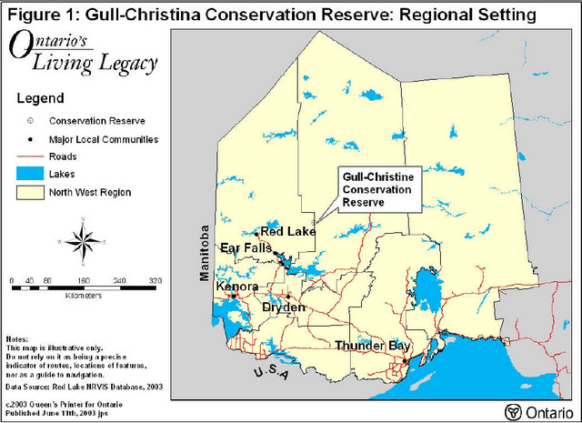
Figure 2: Map - Conservation Reserve