Horseshoe Lake Conservation Reserve Management Statement
This document provides policy direction for the protection, development and management of the Horseshoe Lake Conservation Reserve and its resources.
Statement of Conservation Interest
Ministry of Natural Resources
Parry Sound District
Prepared with the assistance of:
Meteek & Company
Huntsville, Ontario
March 2004
Approval statement
We are pleased to approve this Statement of Conservation Interest for Horseshoe Lake Conservation Reserve (C93).
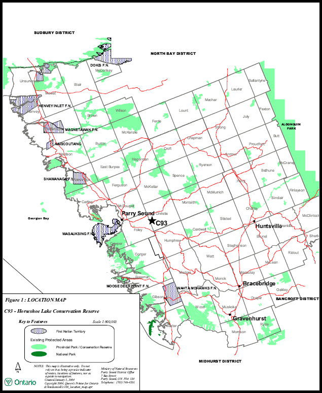
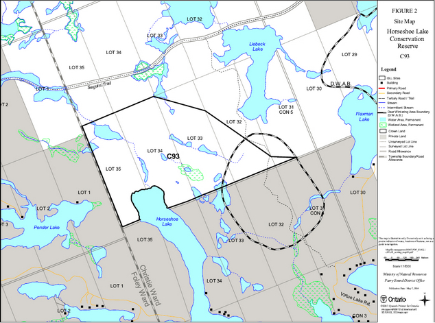
Horseshoe Lake Conservation Reserve is a 115 hectare area of Crown land located about 13 kilometres east-southeast of the Town of Parry Sound. It is in the western part of Christie Ward in the Township of Seguin in the Territorial District of Parry Sound. It extends north from the northern end of Horseshoe Lake to about ¼ kilometre south of the recreational Seguin Trail. Adjacent lands to the south and west are privately owned and are not part of the conservation reserve.
This diverse area in Hills' ecological Site District 5E-7 has at least 22 combinations of vegetation and landforms, including poplar, sugar maple, and mature red oak and white pine stands on hilly, sandy uplands, and mature sugar maple stands on hilly bare bedrock. The area includes habitat where deer concentrate during some winters.
Horseshoe Lake Conservation Reserve is one of 378 new protected areas approved through Ontario’s Living Legacy Land Use Strategy, aimed, in part, at completing Ontario’s system of parks and protected areas. Originally identified as Haines Creek Uplands Conservation Reserve, the name of this site was changed to more accurately reflect its location.
During the "Lands for Life" planning process, the public was widely consulted and provided valuable input into what became Ontario’s Living Legacy Land Use Strategy. Comments received during that time, and during consultation related to the formal Public Lands Act regulation of the boundaries of this conservation reserve, were generally supportive of the protection of this area. Stakeholders who provided comment during the earlier consultation for this site were subsequently consulted regarding the draft Statement of Conservation Interest and their comments were considered in the finalization of this document.
This Statement of Conservation Interest provides guidance for the management of the conservation reserve and provides the basis for the ongoing monitoring of activities. More detailed direction is not anticipated at this time. Should more complex resource management or conservation issues arise or significant facility development be considered, then a detailed Resource Management Plan will be prepared with full public consultation.
Horseshoe Lake Conservation Reserve is managed under the direction of the District Manager and the Parry Sound Area Supervisor of the Ministry of Natural Resources, Parry Sound District.
Approved by:
R. Griffiths
District Manager
Parry Sound District
Approved by:
Ron Running
Regional Director
Southern Region
1.0 Introduction
Ontario’s Living Legacy, the result of an extensive planning process that began in early 1997, culminated in the approval in July 1999 of a Land Use Strategy that identifies the intended strategic direction for Crown land, including the completion of Ontario’s system of parks and protected areas. This process, which included extensive public consultation, resulted in the recommendation for regulation of 378 new protected areas, including Horseshoe Lake Conservation Reserve (C93).
Horseshoe Lake Conservation Reserve is located at the extreme north end of Horseshoe Lake, approximately 5 kilometres north of the junction of Highways 141 and 69, and 13 kilometres east-southeast of the Town of Parry Sound. Municipal road allowances, which abut the west and south edges of this site, are not a part of the conservation reserve.
There is no road access into the conservation reserve, although a snowmobile trail crosses the southeast corner of the site. The recreational Seguin Trail runs less than 1/2 kilometre to the north of the site and is separated from the northern boundary by forested Crown land. The southern end of the site can be accessed by boat via Horseshoe Lake.
The conservation reserve, in Hills' ecological Site District 5E-7, is notable for its diversity of both terrestrial and wetland community types. It was identified during the Ontario’s Living Legacy selection process for its representation of at least 22 different landform-vegetation types in ecological Site District 5E-7. These include poplar, mature red oak and white pine stands on rolling, sandy uplands, as well as mature sugar maple stands. The area includes deer wintering habitat.
Conservation reserves are established under the authority of the Public Lands Act, Ontario Regulation 805/94. Horseshoe Lake Conservation Reserve was established by Ontario Regulation 148/02 on May 8, 2002.
A Statement of Conservation Interest (SCI) is prepared under the direction of Procedural Guideline A - Resource Management Planning (PL. Procedure 3.03.05). The purpose of this SCI is to identify and describe the values of Horseshoe Lake Conservation Reserve. The SCI also outlines the activities that currently occur within the conservation reserve and provides guidelines for the management of current and future activities in the context of protecting the natural, recreational and cultural values.
1.1 Background Information:
| Name | Horseshoe Lake Conservation Reserve (C93) |
|---|---|
| Site Region/District | Georgian Bay 5E-7 |
| OMNR Administrative Region/District/Area | Southern Region/Parry Sound District/ Parry Sound Area |
| Total Area (ha) | 115 hectares |
| Regulation Date | May 8, 2002 (O. Reg. 148/02) |
| First Nations | Robinson-Huron Treaty and Williams Treaty |
| OBM map sheet | 10 17 5850 50150, 5890 50150, 5850 50200, 5900 50200 |
| Topographic Map | Orrville 31 E/5 |
| UTM coordinates | 17T 58980 501990 (Centroid) |
1.2 Representation
Earth science representation:
Moon Island gneiss association rocks, consisting of quartz diorite, mafic gneiss and quartz-biotite-feldspar gneiss, of the Parry Sound Domain.
Bedrock knobs, overlain with thin discontinuous drift characterize this site, with patches of glaciofluvial sand and/or gravel in low lying areas.
Life science representation:
Horseshoe Lake Conservation Reserve was identified during the Ontario’s Living Legacy selection process for its representation of at least 22 different landform-vegetation types in ecological Site District 5E-7. These include poplar, mature red oak and white pine stands on rolling, sandy uplands, as well as mature sugar maple stands.
Cultural resources representation:
Neither detailed cultural research nor inventory have been carried out for this conservation reserve. Recent regional evaluation (OMNR, 2003) shows that this conservation reserve contains areas that have some potential for cultural heritage sites.
Recreational opportunities:
A recreational inventory report was prepared for this conservation reserve based on existing knowledge and data sources of MNR staff, and recent site visits. Currently, the site is used chiefly for hunting and snowmobiling.
1.3 Survey work
| Survey Level | Earth Science | Life Science | Cultural | Recreational | Other |
|---|---|---|---|---|---|
| Reconnaissance | Blackburn 2003. | Jalava, 2003 | OMNR, 2003 | Larson, 2003 | None |
| Detailed | None | None | None | None | None |
| Requirement | None | Monitor the status/presence of significant species and associations. | Research to be encouraged | Monitor use impacts | None |
2.0 Values to be protected
The conservation reserve is located entirely within Hills' (1959) ecological Site District 5E-7. Values include earth science, life science and recreational/aesthetic values, with an emphasis on the life sciences.
2.1 Earth science:
(Earth science information, unless otherwise noted, is taken from Blackburn, 2003)
Bedrock:
Horseshoe Lake Conservation Reserve lies within the Parry Sound Domain, Parry Sound Terrane, of the Central Gneiss Belt in the Proterozoic Grenville Province. (Easton 1992 a, b) The Parry Sound Domain has been divided into a number of gneiss associations. This site appears to be underlain by rocks of the Moon Island gneiss association, close to their contact with McLaren Island gneiss association rocks that lie to the south. Easton (1992a) indicates that Moon Island gneiss association rocks are dominantly metaplutonic, and mostly intermediate in composition. They also contain a unique set of plagioclase-rich mafic dikes. Diorite and quartz diorite plutons make up the bulk of the Terrane.
The Grenville Province is the product of thrusting and imbrication of the crust to the northwest as it collided with a continental landmass to the southeast. The Grenville Orogeny, circa 1140 to 1070 million years ago, culminated more than 500 million years of crustal evolution. The eroded roots of the products of these events are displayed in the complexly metamorphosed and deformed rocks of the region (Easton, 1992b).
The Parry Sound Terrane is one of four lithotectonic terranes of the Central Gneiss Belt. Within the Parry Sound Terrane, the Parry Sound Domain is one of three structural domains. This geological environment is part of the modern organization of the complex products of the mid-Proterozoic Grenville orogenic events (Easton, 1992a & b). As such, their representation in Horseshoe Lake Conservation Reserve contributes to the conservation of the Grenville continental accretion theme outlined by Davidson (1981).
Within the Ontario Provincial Park system, the bedrock geological features of Horseshoe Lake Conservation Reserve have local significance in the representation of Moon Island gneiss association of the Parry Sound Domain, Parry Sound Terrane.
Surficial:
Bedrock knobs characterize this site. Thin discontinuous drift overlies bedrock, with patches of glaciolacustrine or glaciofluvial sand and/or gravel in low lying areas. No significance is given to the surficial geology.
2.2 Life science:
(Life science information, unless otherwise noted, is taken from Jalava, 2003)
The conservation reserve is located within Hills' (1959) ecological Site District 5E-7. Life science significance is determined on the basis of the following criteria: representation, diversity, condition, ecological considerations and special features (Crins and Kor, 1998).
Representation:
Two major forest types predominate in the upland portions of the site. Mature deciduous forests dominated by sugar maple (Acer saccharum), basswood (Tilia americana), yellow birch (Betula alleghaniensis), red oak (Quercus rubra) and beech (Fagus grandifolia) cover much of the western half of the conservation reserve. The drier, shallower soil s of the site’s eastern half support mixed fire-successional white pine (Pinus strobus) - red oak associations, usually in association with red maple (Acer rubrum), white birch (Betula papyrifera) and large-toothed aspen (Populus grandidentata). A variety of wetland types are also present, being particularly abundant in the eastern two-thirds of the site. They range from aquatic communities in small lakes and beaver ponds, to meadow marshes, treed swamps, shore fens and a well-developed shrub bog.
The character of the sugar maple forests that dominate much of the western half of the conservation reserve varies depending on soil moisture and topographic position. On fresh soils along the east-facing lower slope of the stream valley north of Horseshoe Lake, basswood is co-dominant with sugar maple, with yellow birch as a frequent associate. This rich stand has an extensive sub-canopy of sugar maple saplings and seedlings, while the understorey is strongly dominated by red trillium, with wild lily-of-the-valley (Maianthemum canadense), spinulose wood fern (Dryopteris carthusiana), false Solomon’s-seal (Maianthemum racemosum), hairy Solomon’s-seal (Polygonatum pubescens) and white-lettuce (Prenanthes alba) also common. Slightly drier upper slopes support sugar maple - yellow birch - beech associations. There is a particularly impressive, mature sugar maple - yellow birch stand just south of the unnamed lake at the northwest corner of the conservation reserve. Dominant species in the understorey of these stands include striped maple (Acer pensylvanicum) and hobblebush (Viburnum lantanoides) in the shrub layer, and spinulose wood fern, rose twisted-stalk (Streptopus roseus) and red trillium. Sugar maple regeneration is abundant.
Red oak - sugar maple - large-toothed aspen - ironwood (Ostrya virginiana) stands occur on the dry-fresh soils atop ridge crests and bedrock knobs in the western half of the conservation reserve. Striped maple is frequent as a tall shrub or sapling, while the ground cover consists primarily of sugar maple seedlings and large-leaved aster (Eurybia macrophylla), wild sarsaparilla (Aralia nudicaulis), wild lily-of-the-valley, various sedges (Carex communis, C. arctata and C. leptonervia) and bracken fern (Pteridium aquilinum).
In the fire-successional forests of the eastern half of the site, white pine is often strongly dominant, with red oak usually the secondary dominant, or occasionally co-dominant on deeper, moister soils. Frequent associates are white birch, red maple and large-toothed aspen. Ironwood and sugar maple are occasionally common in the sapling layer, particularly in communities that are transitional with deciduous stands. White pine and red oak saplings are infrequent, and there is generally no tall shrub layer. Lowbush blueberry (Vaccinium angustifolium) is the most frequent low shrub, with occasional Common Juniper (Juniperus communis) in the vicinity of exposed bedrock. Crinkled hairgrass (Deschampsia flexuosa), wild lily-of-the- valley, large-leaved aster, wild sarsaparilla, bracken fern and, occasionally, wintergreen (Gaultheria procumbens), are the most common species in the relatively sparse herb layer. Haircap mosses (Polytrichum spp.) are often common in these forests. The locally uncommon squawroot (Conopholis americana), which is parasitic on oak roots, occurs in this community type.
A few patches of open rock barren occur atop the bedrock knobs of the western half of the site, but are much more frequent in the eastern half, where they are interspersed with patches of the white pine - red oak forests and various wetlands. The sparse soils on the rock barrens support pioneering graminoids and non-vascular plants. The dominant species are crinkled hairgrass, poverty oat grass (Danthonia spicata), common sedge (Carex communis) and the introduced sheep-sorrel (Rumex acetosella). Non-vascular dominants include haircap mosses and reindeer lichen (Cladonia rangiferina). Common juniper shrubs and scattered red oak and white pine trees and saplings also occur on the patches of rock barren.
At the east end of the unnamed lake at the northwest corner of the conservation reserve, there is an interesting sparsely-vegetated community that probably formed as the result of a natural disturbance. It occurs on a steep, rocky southwest-facing slope with dry light grey-brown sandy soil. Bracken fern is the most common species, with crinkled hairgrass and poverty oat grass also frequent. A small cliff inclusion within this patch sustains a colony of rusty woodsia (Woodsia ilvens is). Another interesting micro-community occurs on a very steep 35 m east-facing slope just northwest of the northern tip of Horseshoe Lake. Although surrounded by mature sugar maple forests, the slope is too steep to support extensive tree growth and is habitat for the locally significant divaricate rock-cress (Arabis divaricata).
Coniferous, mixed and deciduous swamps are occasional in poorly drained shallow depressions at the conservation reserve. Tamarack (Larix laricina) - black spruce (Picea mariana) associations were noted at two locations, with a sphagnum moss carpet. Frequent tree and sapling associates in these swamp forests are red maple and white pine, while northern wild-raisin (Viburnum cassinoides) and mountain holly (Nemopanthus mucronatus) form a sparse shrub layer. The most common herbaceous dominant is cinnamon fern (Osmunda cinnamomea), with royal fern (Osmunda regalis), wild lily-of-the-valley, starflower (Trientalis borealis) and three-seeded sedge (Carex trisperma var. trisperma) as associates.
Water levels appear to have receded considerably along the south-flowing stre am in Lot 34 south of the unnamed lake at the northwest corner of the site because of beaver activity upstream. At the outlet of the creek at Horseshoe Lake, this drawn-down ‘floodplain' supports a small red maple deciduous swamp. Several trees appearing to be the locally significant hybrid maple, (Acer X freemanii), occur in this community. The understorey is diverse and highly variable, grading into adjacent mead ow marshes. Soil moisture varies from saturated along the creek to mesic conditions on hummocks. Occasional dense patches of winterberry (Ilex verticillata), mountain holly and northern wild-raisin occur, while the most common herbaceous species are sens itive fern (Onoclea sensibilis), lady fern (Athyrium filix-femina), bunchberry (Cornus canadensis) and Royal Fern. The adjacent meadow marshes, which extend for more than 300 m upstream, are dominated by spotted jewelweed (Impatiens capensis), nodding sedge (Carex gynandra) and Canada bluejoint (Calamagrostis canadensis). Rough goldenrod (Solidago rugosa), arrow-leaved tear-thumb (Polygonum sagittatum), sallow sedge (Carex lurida), marsh pennywort (Hydrocotyle americana), wool-grass (Scirpus cyperinus) and northern St. John’s-wort (Hypericum boreale) are also frequent. Along the stream, soft rush (Juncus effusus) and green-fruited bur-reed (Sparganium emersum) are common.
Small meadow marshes, winterberry thicket swamps and ephemeral ponds occur in small patches within the white pine - red oak forests in the eastern half of the site. More extensive meadow marshes occur along the margins of small lakes and beaver ponds. There is a sizeable wool-grass-three-way sedge (Scirpus cyperinus) meadow marsh along the eastern boundary of the site. Also frequent in the eastern half are small peatlands, which often occur as broken peat mats in beaver-flooded areas. These poor fens or shore fens are dominated by leatherleaf (Chamaedaphne calyculata) and/or sweet gale (Myrica gale) shrubs, with a variable herb layer usually dominated by three-way sedge, tussock sedge (Carex stricta), swamp candles (Lysimachia terrestris), wool-grass, tawny cotton-grass (Eriophorum virginicum) and/or hoary sedge (Carex canescens).
Approximately 300 metres east of the northern tip of Horseshoe Lake is a small but well-developed shrub bog, with a quaking mat and an open bog pool in the middle. Leatherleaf shrubs are dominant, along with tawny cottongrass, few-flowered sedge (Carex pauciflora), Virginia chain fern (Woodwardia virginica), white beaked-rush (Rhynchospora alba), small cranberry (Vaccinium oxycoccos) and hoary sedge.
Aquatic communities are present in most of the small lakes and beaver ponds, and along the Horseshoe Lake shore. Water-shield (Brasenia schreberi), white water-lily (Nymphaea odorata), bullhead lily (Nuphar variegatum) and common bladderwort (Utricularia vulgaris) are common in the shallow standing water of beaver ponds and small lakes. Pickerel-weed (Pontedari a cordata) and green-fruited bur-reed are dominant on the sandy-muck substrate along the Horseshoe Lake shoreline.
Condition:
The mature sugar maple forests of the western portion of the site are notable for their lack of disturbance and the presence of older-growth characteristics, such as canopy gaps and abundant tree-fall and decaying wood.
Only 3% of the vascular plant species documented during the present study are introduced in central Ontario, suggesting low levels of anthropogenic disturbance. One exotic species, hemp-nettle (Galeopsis tetrahit) was therefore surprisingly common in otherwise undisturbed sugar maple forest communities in the southwestern part of the site. Sheep-sorrel is a ubiquitous invasive on rock barrens on the Canadian Shield and is quite common in this restricted habitat within the conservation reserve.
No evidence of recent resource extraction activities was noted at the site. The presence of charred white pine stumps in the southeastern quadrant of the site are evidence of fires that likely followed timber harvest in the early 1900's. According to OMNR digital fire history mapping, the southeastern third of the site burned in the 1920's.
Road and trail development within the site is limited to the snowmobile trail that crosses the extreme eastern tip of the conservation reserve. This track appears to receive occasional all-terrain vehicle use in the summer.
Diversity:
Twenty-two landform-vegetation types were documented during the two-day site inspection of the present study. These vegetation types were defined using standard ecological land classifications of Ontario (Chambers et al. 1997, Lee et al. 1998, NHIC 2002 and Harris et al. 1996), which have been applied to create a complete classification for the greater Georgian Bay area by Jalava et al. (2002). The conservation reserve is notable for its diversity of both terrestrial and wetland community types.
These vegetation types provide habitat for at least 211 vascular plant species. At least seven species of amphibians occur at the site, as well as 4 species of reptiles. Of note are eastern newt and Jefferson salamander complex, both of which are reported by the Ontario Herpetofaunal Summary for the immediate vicinity of the site.
Ecological considerations
The conservation reserve straddles two major watersheds. The site’s western catchment drains southward into Horseshoe Lake which, along with the small lake along the southeastern boundary of the site, drains into the Blackstone River. The northeastern catchment drains into Liebeck Lake east of the conservation reserve, eventually entering the Seguin River system.
Natural vegetation along streams and associated beaver ponds and small lakes helps to maintain water quality throughout the watersheds. The shorelines are areas of high bio-diversity, with the vast majority of aquatic species occurring in the littoral zone near the shore. Most terrestrial fauna also utilize the shoreline ecotone during some portion of their life cycle.
According to OMNR digital mapping (NRVIS 2002), the southeastern portion of the site is part of a deer wintering area.
Area-sensitive forest interior bird species, such as black-throated blue warbler, scarlet tanager and barred owl occur within the conservation reserve. Although not detected during the brief site inspection, the site also contains habitat suitable for breeding by the provincially vulnerable red-shouldered hawk, also a forest-interior species, which is well documented in the general vicinity of the site.
Special features:
The site’s older-growth sugar maple forests are relatively uncommon in southern Ontario, as are the older white pine-red oak forests. The conservation reserve also provides habitat for at least two provincially rare and several locally significant species.
2.3 Cultural values:
While no specific cultural studies or inventories have been undertaken within the conservation reserve, and no major cultural resource values have been evaluated or identified to date, recent regional evaluation (OMNR, 2003) indicates that this conservation reserve contains areas that have some potential for cultural heritage sites, specifically associated with adjacent Horseshoe Lake.
2.4 Recreational/aesthetic values:
The area within the conservation reserve boundaries provides a variety of large and small game hunting opportunities.
An arm of Horseshoe Lake abuts the conservation reserve. Horseshoe Lake is a popular tourist destination with many cottages, and some tourism based commercial properties. It is used for boating and angling, and the Crown shoreline of the north arm may receive some related use. There may also be angling opportunities in the small ponds and lakes in the conservation reserve.
A South Seguin Snowmobile Club snowmobile trail (#201) crosses through the south-east corner of the site, and joins with the well used recreational Seguin Trail about a half a kilometre to the north of the site.
The degree of use by hikers, naturalists, canoeists, mountain bikers, skiers and snowshoers is difficult to determine. It is likely that at present, such activities are minimal because no trails lead to the interior of the site.
The distance of this conservation reserve from urban areas has resulted in a relatively pristine night sky, which enhances the sense of remoteness and wilderness of this site. Pristine night skies are considered a significant value, given the increasingly limited areas of southern and central Ontario which are not heavily affected by light pollution.
3.0 Management guidelines
3.1 Land tenure:
Background:
Horseshoe Lake Conservation Reserve is a 115 hectare area of Crown land located about 13 kilometres east- southeast of the Town of Parry Sound. It is in the western part of Christie Ward in the Township of Seguin in the Territorial District of Parry Sound. It extends north from the northern end of Horseshoe Lake to about ¼ kilometre south of the recreational Seguin Trail. Adjacent lands to the south and west are privately owned and are not part of the conservation reserve. Municipal road allowances, which abut the west and south edges of this site, are not a part of the conservation reserve.
Bear Management Area (PS-49-07) surrounds the conservation reserve, but the area within the conservation reserve is excluded. The conservation reserve is within one Bait Fish Block (PS0137). It lies within one registered trapline area (PS 152) that includes the conservation reserve. There are no authorized recreation camps within the boundaries of the conservation reserve.
An authorized snowmobile trail (#201), maintained by the South Seguin Snowmobile Club, crosses the south east portion of the site, and connects to the recreational Seguin Trail to the north.
Guideline:
The sale of Crown lands within the conservation reserve is not permitted. While the Ontario’s Living Legacy Land Use Strategy provides minor flexibility in this policy, there are no sites adjacent to this conservation reserve which would meet the stipulated criteria.
There are no plans by the MNR to acquire private lands to add to the conservation reserve.
Commercial bear hunting service associated with the surrounding Bear Management Area is not allowed within the boundaries of the conservation reserve, and additional areas of the conservation reserve cannot be incorporated into the Bear Management Area. The Bait Fish Block, currently assigned, is permitted to continue. Fur harvest is permitted to continue in the registered trapline area.
New recreation camps are not permitted.
3.2 Development:
Background:
There are no buildings or Crown-owned facilities within the conservation reserve.
The South Seguin snowmobile trail #201 passes through the southeast corner of the conservation reserve; it receives some off-season use by all-terrain vehicles.
Guideline:
New roads for resource extraction and/or private use will not be permitted. There is no intention to develop roads outside of the conservation reserve to improve access to this site.
In general, existing authorized recreational trails may be permitted to continue in conservation reserves as long as they do not impair the natural features and values for which the area is identified and as long as there are no significant environmental impacts. Accordingly, the authorized snowmobile trail continues to be allowed, but its use will be monitored to ensure that conservation reserve values are not being adversely impacted.
New recreational trails may be considered on a case by case basis provided that they meet Procedural Guideline B - Land Uses - Test of Compatibility (see Appendix 1) and the MNR's Environmental Assessment Act requirements. Public consultation will generally be required during the consideration of changes to existing trails, and will always be required for new trails.
New recreational trails for motorized vehicles will not be permitted, unless the following have been demonstrated:
- there is a community need for the trail, as well as community support
- there are no alternative suitable locations outside the conservation reserve
- the trail location would be acceptable and suitable for four-season use
- the trail would meet the requirements applicable to all trails, as identified in the preceding paragraph
Unauthorized works within the conservation reserve will be handled in accordance with the Public Lands Act, and any required removal of improvements will be at the expense of those responsible.
No mineral exploration is permitted within this conservation reserve. This policy decision is based on a commitment made by the Ministry of Natural Resources and the Ministry of Northern Development and Mines in March, 2002. This policy direction replaces that identified in the 1999 Ontario’s Living Legacy Land Use Strategy (OMNR, 1999), which stated that controlled mineral exploration would be permitted in new conservation reserves which were identified as having provincially significant mineral potential.
Any new development must meet MNR's commitments to protect cultural heritage values (see Section 3.7).
While there is no intent at present to provide or permit any new development in this conservation reserve that would require lighting, should this be considered at some point in the future the MNR will not allow unnecessary, undirected light pollution. This commitment recognizes the wilderness values provided by a pristine night sky.
3.3 Recreational activities:
Background:
Existing recreational uses include hunting and snowmobiling. Most hunting activity in the conservation reserve focuses on white-tailed deer, moose and black bear. There may be some angling in the small lakes and ponds bordering or within the site.
The north arm of Horseshoe Lake is used for boating and angling, and there may be some associated use of the shoreline within this site.
An authorized snowmobile trail crosses the conservation reserve (See Sections 2.4 and 3.2). In addition to snowmobiling, all-terrain vehicle use occurs on that trail.
There is little evidence of the use of the conservation reserve by hikers, birdwatchers, mountain bikers, skiers, or snowshoers.
Guideline:
Hunting and angling are permitted to continue within the conservation reserve.
Recreational use such as hiking, wildlife viewing, camping, snowshoeing, and cross-country skiing, while currently very limited in extent and therefore not managed, will be allowed to occur in the conservation reserve.
The currently authorized snowmobile trail will continue to be authorized. It is not expected to have much impact on the conservation reserve, unless off-trail use occurs from it. Off-trail use of snowmobiles and all- terrain vehicles is only permitted for the direct retrieval of game. Trail use and off-trail use will be monitored to ensure that the conservation reserve values are not being adversely impacted.
As discussed in Section 3.2 Development, new recreational trails may be considered on a case by case basis provided that they meet Procedural Guideline B - Land Uses - Test of Compatibility (see Appendix 1) and the MNR's Environmental Assessment Act requirements. Public consultation will generally be required during the consideration of changes to existing trails, and will always be required for new trails. Any new trails must meet MNR's commitments to protect cultural heritage values (see Section 3.7).
New recreational trails for motorized vehicles will not be permitted, unless the following have been demonstrated:
- there is a community need for the trail, as well as community support
- there are no alternative suitable locations outside the conservation reserve
- the trail location would be acceptable and suitable for four-season use
- the trail would meet the requirements applicable to all trails, as identified in the preceding paragraph
The use of unauthorized recreational trails that existed at the time of regulation of this conservation reserve, and any increased use of all-terrain vehicles, will be monitored to ensure that conservation reserve values are not being adversely impacted. Depending on the results of monitoring, some trails may need to be redirected from sensitive areas or eliminated completely. Otherwise, there is no intent to mark or upgrade such trails.
New recreational activities will be considered on a case by case basis provided they are consistent with maintaining the values of the conservation reserve and comply with Procedural Guideline B - Land Uses - Test of Compatibility (Appendix 1). Emphasis will be placed on activities that have a low impact on the environment of the conservation reserve.
Monitoring of existing and permitted activities will be undertaken as required to ensure that the conservation reserve values are not being adversely impacted.
3.4 Commercial activities:
Background:
There has been no recent commercial forest harvesting or mining activity within the conservation reserve.
Commercial fur harvesting is authorized through registered traplines, and bait fish harvesting is authorized through a Bait Fish Block licence within the conservation reserve. The surrounding Bear Management Area does not include the conservation reserve. These activities were discussed in Section 3.1 Land Tenure-Background.
Guideline:
Fur harvesting and bait fish harvesting operations are allowed to continue within the conservation reserve. New trapline cabins are not permitted within conservation reserves.
Because this site is excluded from the surrounding Bear Management Area, the guiding of non-resident bear hunters is not authorized in this site.
Mineral exploration is not allowed in this conservation reserve, as discussed in Section 3.2.
Conservation reserve regulations do not permit mining, commercial forest harvesting, hydroelectric power development, the extraction of aggregate and peat or other industrial uses (Public Lands Act). Other new commercial activities must meet the requirements of Procedural Guideline B - Land Uses - Test of Compatibility (see Appendix 1).
3.5 Aboriginal interests:
Background:
This site is known to be of interest to many First Nation communities. There are 2 treaties associated with the area: the Robinson - Huron Treaty of 1850 and the Williams Treaty. A Supreme Court decision in 1994 (Howard) validated that the Williams Treaty surrendered hunting, fishing and trapping rights of those First Nations affiliated with that treaty.
Guideline:
The regulation and management of this conservation reserve will not impede the exercise of existing aboriginal or treaty rights. These rights include hunting, fishing, fur harvesting, gathering of plants for a variety of purposes, and the use of ceremonial sites. It is recognized that the manner in which these rights are carried out is not limited to the manner in which they were carried out in the past, but has evolved over time with changes in technology.
While there are no existing First Nation land claims that extend to this site, it is recognized that at some point in the future there is a possibility of a land claim in this area. If such a land claim is determined to be valid, the conservation reserve designation is not irreversible and does not preclude consideration of these lands in the settlement of a claim. If deregulation of part or all of a conservation reserve occurs as part of the settlement of a claim, this will be carried out at no cost to First Nations.
3.6 Natural resource stewardship:
Background:
Vegetation management for specific purposes (other than historic logging) is not known to have occurred in the past. Wildlife and fisheries management has occurred according to the prevailing policies and legislation.
The emphasis will be on ensuring that the natural values of the conservat ion reserve are not negatively affected by current and future activities. Therefore, applications for new specific uses will be carefully studied and reviewed. Necessary studies may be undertaken by proponents, the Ministry, and/or partner organizations.
Guideline - vegetation:
The intent of this site is to allow the existing vegetation communities to evolve naturally.
An exception to the above may occur to manage the vegetation components critical to wintering deer. The southeast corner of this site overlaps a deer wintering area. The Ontario’s Living Legacy Land Use Strategy (Appendix A - Land Use Intent) provides direction that "Vegetation management (deer habitat) to be provided for and addressed in Statements of Conservation Interest". Vegetation management and featured species management (deer in this case) is consistent with Conservation Reserve Policy PL 3.03.05.
The purpose of habitat management would be preservation and in some cases regeneration of the conifer trees, especially hemlocks, which provide cover from winter conditions, along with the creation of areas of browse in close proximity to conifer cover. It is anticipated that this habitat management would occur during the winter, thereby alleviating the need for any new/upgraded roads to undertake this activity.
Prior to work of this nature being done, a vegetation management plan would be completed by MNR and approved by the MNR District Manager. This vegetation management plan would be directed by local MNR specialists (e.g. area forester, area wildlife biologist) and reviewed with life science specialists/ecologists of Ontario Parks, to ensure that the habitat management would not adversely affect the natural heritage and ecological representation values of this conservation reserve. The habitat management prescriptions would generally be consistent with the approved Area of Concern provisions used for forestry operations in identified deer yards in the French-Severn Forest Management Plan, which in turn is derived from Forest Management Guidelines for the Provision of White-Tailed Deer Habitat (OMNR, 1997), except where modifications are needed to protect certain heritage values or features of this site.
The vegetation management plan could be implemented in several ways; for example, volunteer labour can be used if available or a commercial operator could be contracted by the MNR. In either case, it is expected that harvested forest products could be marketed commercially to offset the costs of the work.
The OMNR recognizes fire as an essential process fundamental to the ecological integrity of this conservation reserve. In accordance with existing conservation reserve policy and the Forest Management Strategy for Ontario, forest fire protection will endeavour to use "light on the land" techniques, which do not unduly disturb the landscape, in this conservation reserve. Examples of light on the land techniques may include limiting the use of heavy equipment, and limiting the number of trees felled during fire response efforts. Input from the local MNR Area Supervisor would be solicited if a forest fire threatens the area. Opportunities for prescribed burning to achieve resource management objectives may be considered. Plans for any prescribed burning will be developed in accordance with the OMNR Prescribed Burn Planning Manual.
Programs may be developed to control forest insects and diseases in the conservation reserve where these threaten significant values in or adjacent to the site. Where insects or disease threaten significant values, in or adjacent to the site, and MNR determines that control is warranted, control within the conservation reserve will be directed by the MNR as narrowly as possible to the specific insect or disease. Biological control will be used wherever possible. In all cases, regard shall be had for Procedural Guideline B - Land Uses - Test of Compatibility (see Appendix 1).
Guideline - wildlife and fisheries:
The relevant Ontario hunting and fishing regulations will guide hunting and fishing within Horseshoe Lake Conservation Reserve. Bait fish harvesting will be managed through the maintenance of the current licensing system.
The Ministry will monitor the impacts of activities of snowmobile trails and increasing use of all-terrain vehicles on the natural values of the conservation reserve.
3.7 Cultural resource stewardship:
Background:
Recent regional evaluation (OMNR, 2003) indicates that this conservation reserve contains areas that have some potential for cultural heritage sites. However, no specific studies or inventories have been undertaken within the conservation reserve, and no specific significant cultural resource values have been evaluated or identified to date.
Guideline:
Should the MNR consider either carrying out or permitting new structural development, significant clearing of vegetation or altering of land within this conservation reserve, the MNR will adhere to the cultural heritage resource screening process as is identified in its Memorandum of Understanding (MOU) with the Ministry of Culture. While the purpose of this MOU is to provide a process to identify and protect cultural heritage resources when the MNR is reviewing work permits or disposing of Crown rights under the authority of the Public Lands Act, the considerations and criteria would also enable the MNR to identify high potential cultural heritage areas for other purposes within conservation reserves. If the screening process indicates that the site of a proposed activity is within an area of high cultural heritage potential, the MNR will consult with the Ministry Of Culture to determine the appropriate cultural heritage assessment requirements and will undertake a preliminary archaeological assessment if appropriate.
Interested partners will be encouraged to undertake inventories, studies, and research to document the histories of First Nations, settlement, resource harvest/management and recreation in the area. The MNR will discuss the appropriateness of any proposed archaeological assessment with local First Nations and the Ministry of Culture.
3.8 Client services:
Background:
Access to the conservation reserve has generally been confined to traditional uses for the current commercial and recreational activities. There are no Crown facilities or services developed on or adjacent to the conservation reserve. The information fact sheet for this conservation reserve is currently available to the public through the Parry Sound District Office, or via the Internet at www.ontarioslivinglegacy.com (link no longer active).
Guideline:
The focus will remain on low key information and self-interpretation of conservation reserve values and features. Consideration will be given to the preparation of an information brochure (with map) to highlight the features for which the area was identified and appropriate uses to ensure the protection of those features.
Consideration will be given to the strategic location of identity signs where the authorized snowmobile trail crosses the conservation reserve boundaries. There are no other plans for structural development within this conservation reserve.
3.9 Research:
Background:
Research to date has included reconnaissance surveys to document life science, earth science and recreation values.
Guideline:
Research focussing on the assessment of use and activity impacts on cultural resources, sensitive species and habitats will be encouraged.
Research focussing on the prehistoric and historic use of Horseshoe Lake and the conservation reserve will be encouraged.
All research will be carried out in a non-destructive manner. Research proposals must follow Procedural Guideline C - Research Activities in Conservation Reserves (Appendix 3).
3.10 Marketing:
Background:
There has been no marketing of this conservation reserve to date. Promotion and information about this site has been primarily through the Ontario’s Living Legacy planning process and recent MNR Parry Sound District public consultation regarding the boundaries of this site.
Guideline:
Marketing activities of this conservation reserve will be kept to a minimum.
4.0 Implementation
Administrative responsibility for this conservation reserve belongs to the Parry Sound Area Office of the Parry Sound District of the Ministry of Natural Resources. The Area Office will continue to have the custodial care of Horseshoe Lake Conservation Reserve. Emphasis will be placed on awareness information highlighting reserve values, and monitoring and managing the current approved uses.
Priorities will include:
- Ensure compliance to prescribed management direction of the approved SCI
- Monitor and evaluate existing and allowed recreational and commercial use levels and impacts as required to ensure that conservation reserve values are not being adversely impacted
- Encourage further inventory and research of the significant life science resources of the conservation reserve
- Encourage research about use/activity impacts on cultural resources, sensitive species and habitats
- Support cooperative ongoing education of resource users with respect to resource and land stewardship values, in order to maintain the ecological integrity of the site and to provide long term recreational opportunities; and
- Provide client services (e.g. brochure or fact sheet) at nearby MNR offices
5.0 Review and revision of the Statement of Conservation Interest
This Statement of Conservation Interest will be amended through a standard process of minor and major amendments. Minor amendments will be processed in a relatively informal manner and will require the approval of the Area Supervisor. These amendments will deal with uses and activities that do not affect any of the policies in this SCI (e.g. new uses and/or activities that are consistent with existing permitted uses).
Uses and/or activities that were not anticipated in the approved SCI and which may have an impact on the values of the conservation reserve will require a major amendment. This will include an opportunity for public comment and input, and will require the approval of the District Manager and Regional Director.
6.0 References
Blackburn, C. E. 2003. C93 Horseshoe Lake Conservation Reserve. Earth Science Report, OMNR Peterborough.
Chambers, B. A., B. J. Naylor, J. Nieppola, B. Merchant and P. Uhlig. 1997. Field Guide to Forest Ecosystems of Central Ontario; SCSS Field Guide FG-01. Ontario Ministry of Natural Resources.
Crins, W. J. and Kor, P. S. G. 1998. Natural Heritage Gap Analysis Methodologies Used by the Ontario Ministry of Natural Resources. Unpublished Paper. Peterborough: OMNR.
Davidson, R. J. 1981. A framework for the conservation of Ontario’s earth science features. Ontario Ministry of Natural Resources, Toronto.
Easton, R. M. 1992a. The Grenville Province and the Proterozoic history of central and southern Ontario; in Geology of Ontario, Ontario Geological Survey, Special Volume. 4, Part 2.
Easton, R. M. 1992b. Tectonic evolution of Ontario. Part 3: Mesoproterozoic evolution of the southeast margin of Laurentia; in Geology of Ontario, Ontario Geological Survey, Special Volume 4, Part 2.
Harris, A. G., S.C. McMurray, P. W. C. Uhlig, J. K. Jeglum, R. F. Foster and G. D. Racey. 1996. Field guide to the wetland ecosystem classification for northwestern Ontario. Ontario Ministry of Natural Resources, Northwest Science and Technology Unit, Thunder Bay. Fiel d Guide FG-01.
Hills, G. A. 1959. A Ready Reference to the Description of the Land of Ontario and its Productivity. Ont. Dept. of Lands and Forests, Division of Research, Maple, Ontario.
Jalava, J. V. 2003. Natural Heritage Area - Life Science Checksheet Horseshoe Lake Conservation Reserve. OMNR, Parry Sound.
Jalava. J. V., W. L. Cooper and Ben-Oliel R. 2002. Georgian Bay Coast Project - Phase I Summary. The Nature Conservancy of Canada, Toronto.
Larson, S. 2003 Recreation Resource Inventory Report. Horseshoe Lake Conservation Reserve. OMNR Parry Sound.
Lee, H. T., W. D. Bakowsky, J. Riley, J. Bowles, M. Puddister, P. Uhlig and S. McMurray. 1998. Ecological Land Classification for Southern Ontario: First Approximation and Its Application. OMNR, Southcentral Science Section, Science Development and Transfer Brancyh. SCSS Field Guide FG-02.
Natural Heritage Information Centre. 2002. Natural Areas and Element Occurrence Databases. Ontario Ministry of Natural Resources, Peterborough.
Ontario Ministry of Natural Resources. 1999. Ontario’s Living Legacy: Land Use Strategy. Queen’s Printer for Ontario.
Ontario Ministry of Natural Resources. 2003. Cultural Heritage Registered Site Reserves and Areas of High Potential, Parry Sound District, Scale 1:150000.
Appendices
Appendix 1: Procedural Guideline B - Land Uses - Test of Compatibility (PL Procedure 3.03.05)
The conservation reserve policy provides broad direction with regard to the permitted uses. The policy provides only an indication of the variety of uses that will be considered acceptable in conservation reserves. The only caution is that "any new uses, and commercial activities associated with them, will be considered on a case by case basis, and, they must pass a test of compatibility to be acceptable." What does a ‘test of compatibility' mean?
An examination of this must start from the premise of why an area is set aside - specifically, its representative natural heritage values. Criteria are then identified to guide compatibility considerations. These criteria apply to the long-term acceptability of both existing uses and new uses.
-
Conformity to SCI/RMP: SCI describe values for which an area has been set aside and the range of appropriate uses that will be permitted in the area. SCI may also speak to the acceptability of other 'new' uses currently not occurring in the area.
The first 'test' is: "do proposed new land uses and/or commercial activities conform to the direction of the SCI/RMP for the conservation reserve? Would the new use(s) depart from the spirit of appropriate indicator land uses in the SCI/RMP?"
- Impact Assessment: If the proposed use(s) pass test 1 it is important to determine their impact on the area before they are approved. This should include the following:
- Impact on natural heritage values: "will the new use(s) impact any natural values in the area? If so how and to what degree? Is it tolerable?"
- Impact on cultural values: "will the new use(s) impact an historical or archaeological values in the area?"
- Impact on research activities: "will the new use(s) affect research activities in the area?"
- Impact on current uses: "will the new use(s) have any negative impact on the array of current uses?"
- Impact on area administration: "will the new use(s) increase administrative costs and/or complexity?" (For example, the cost of area monitoring, security and enforcement).
- Impact on accommodating the use outside the conservation reserve: "Could the use(s) be accommodated as well or better outside the conservation reserve?"
- Impact on socio-economics of the area: "will the new use(s) affect the community(ies) surrounding the area in a positive or negative way?" (For example, will the new use make an area less remote thereby affecting a local tourism industry that is dependent on the area’s remoteness for its appeal?"
- Impact on area accessibility: "does the new use(s) give someone exclusive rights to the area or a portion of the area to the exclusion of other existing uses?"
The following table (Appendix 2) provides a guide of indicator uses for the consideration of uses that may be permitted within conservation reserves. For any specific conservation reserve that test of compatibility should be applied to determine which specific uses are acceptable.
Appendix 2: Indicator uses for conservation reserves: generic and specific
Recreation
| Activities | Generic Policy Permitted? Existing | Generic Policy Permitted? New | Specific Application in Horseshoe Lake Conservation Reserve |
|---|---|---|---|
| Sport Fishing | Yes | Yes | Yes |
| Sport hunting | Yes | Yes | Yes |
| Food gathering | Yes | Yes | YesA |
| Facility infrastructure | Maybe | Maybe | Maybe |
| Off-trail snowmobiling | No1 | No1 | No1 |
| Off-trail all-terrain vehicle use | No1 | No1 | No1 |
| Rock climbing/caving | Maybe | Maybe | Maybe |
| Canoeing/kayaking | Yes | Yes | Yes |
| Motorized boating | Yes | Yes | Yes |
| Picnicking | Yes | Yes | Yes |
| Camping | Maybe | Maybe | Yes |
| Trails: Hiking | Yes | Maybe | MaybeB |
| Trails: Cross country skiiing | Yes | Maybe | MaybeB |
| Trails: Cycling | Yes | Maybe | MaybeB |
| Trails: Horse riding | Yes | Maybe | MaybeB |
| Trails: Snowmobiling | Yes | Maybe | MaybeB |
| Trails: All-Terrain Vehicles | Yes | Maybe | MaybeB |
Science, education & heritage appreciation
| Activities | Generic Policy Permitted? Existing | Generic Policy Permitted? New | Specific Application in Horseshoe Lake Conservation Reserve |
|---|---|---|---|
| Research | Yes | Yes | Yes |
| General walking | Yes | Yes | Yes |
| Photography & Painting | Yes | Yes | Yes |
| Wildlife viewing | Yes | Yes | Yes |
| Outdoor Education/Interpretation | Yes | Yes | Yes |
| Collecting | No | Maybe2 | Maybe2 |
Commercial activities
| Activities | Generic Policy Permitted? Existing | Generic Policy Permitted? New | Specific Application in Horseshoe Lake Conservation Reserve |
|---|---|---|---|
| Food harvesting | Maybe | Maybe | No |
| Fishing | Maybe | Maybe | No |
| Baitfish harvesting | Yes | Maybe | Yes3 |
| Fur harvesting | Yes | Maybe | Yes3 |
| Trap cabins | Yes | No | NoC |
| Resort - outpost camp | Yes | No | No |
| Outfitting - bear management | Yes | No | No |
| Wild rice harvesting | Yes | Maybe | Maybe |
Resource management
| Activities | Generic Policy Permitted? Existing | Generic Policy Permitted? New | Specific Application in Horseshoe Lake Conservation Reserve |
|---|---|---|---|
| Inventory monitoring | Yes | Yes | Yes |
| Featured species management | Maybe | Maybe | Maybe |
| Natural systems management | Maybe | Maybe | Maybe |
| Insect and disease control | Maybe | Maybe | Maybe |
Industrial activities
| Activities | Generic Policy Permitted? Existing | Generic Policy Permitted? New | Specific Application in Horseshoe Lake Conservation Reserve |
|---|---|---|---|
| Timber harvesting | No | No | No |
| Mineral exploration | Maybe | Maybe | No |
| Mining | No | No | No |
| Hydro generation | No | No | No |
| Energy transmission corridors | Yes | No4 | No4 |
| Communications corridors | Yes | No4 | No4 |
| Public transportation corridors | Yes | No4 | Maybe4 |
| Resource access roads | Maybe | No | No |
| Private access roads | Maybe | No5 | No |
Other activities
| Activities | Generic Policy Permitted? Existing | Generic Policy Permitted? New | Specific Application in Horseshoe Lake Conservation Reserve |
|---|---|---|---|
| Land Disposition | Maybe6 | No6 | No6 |
| Recreation camps | YesC | No | No |
Notes: On generic policy application in conservation reserves:
1 For direct retrieval of game only.
2 Only as a part of an approved research project.
3 Transfer requests will be considered in the context of the Statement of Conservation Interest or Resource Management Plan for each conservation reserve.
4 Existing use is permitted to continue. New transportation corridors, communications lines, and transmission lines are discouraged in conservation reserves except under unusual circumstances where there are no other viable alternatives.
5 New private roads, including additions to existing roads, will not be permitted except where there are existing commitments.
6 Sale of Crown lands in conservation reserves is not permitted, except for certain minor dispositions (e.g. sale of small parcel of land where adjacent private lot is too small to enable installation of a septic system, or to facilitate legal title to lands where there has been a long-standing encroachment of a dwelling on Crown land) where they do not detrimentally affect the values an area is intended to protect.
On specific policy application in Horseshoe Lake Conservation Reserve:
A Food gathering is permitted for personal consumption only and must be conducted in a sustainable manner, and such that it does not harm the values of the conservation reserve.
B Existing authorized trails are permitted to continue in conservation reserves as long as there are no significant environmental impacts and they do not impair the natural features and values for which the area is identified. Additional high impact recreational trails are discouraged, but new trails may be considered on a case by case basis, provided they comply with Procedural Guideline B – Land Uses – Test of Compatibility (Appendix 1), and the MNR's Environmental Assessment Act requirements.
C Existing authorized uses can continue. New cabins, outpost camps and private recreation camps are not permitted.
Appendix 3: Procedural Guideline C
Research Activities in Conservation Reserves (PL Procedure 3.03.05)
Purpose
To encourage contributions to the goal of conservation reserves by:
- Providing direction for research activities associated with conservation reserves; and
- Establishing a process for the review and approval of proposals by researchers, which could have an impact on the values protected by the conservation reserve
Definition
Research means any investigation or study of the natural, cultural, economic, management or other features or characteristics of conservation reserves.
Guidelines
Research will be encouraged to provide a better understanding of the natural values protected by a conservation reserve and to advance their protection, planning and management. The Statement of Conservation Interest will define, for each conservation reserve, the key research issues, set out the parameters within which research may occur and identify research needs.
Applications and approvals
Researchers must apply in writing to the Area Supervisor for permission to conduct research. The request letter must contain a statement explaining why the proposed research should be undertaken in the particular conservation reserve in preference to another location.
Proposals will be reviewed and approved by the Area Supervisor, guided by the SCI prepared for each reserve (see Guideline A - Resource Management Planning) and using Guideline B - Land Uses - Test of Compatibility. Permission must be granted in writing, including any conditions to be met in conducting the research, prior to the undertaking of any research project.
Term and conditions
Permission to conduct research under this policy will be valid for a period of 12 consecutive months from the date of issue. Permission to continue a research project for an additional period of 12 months or less may be granted upon submission of a written request and a progress report. The Ministry may require the posting of collateral to assure that the terms and conditions of granting permission are met.
The Area Supervisor may suspend or revoke permission at any time for failure on the part of the researcher to meet:
- The intent of this policy
- The requirements under the Public Lands Act, Ontario Regulation 805/94 including all amendments, where applicable
- The requirements under any other Act or regulations of Ontario or Canada, including those governing the taking, handling, storing, confining, fur harvesting, excavating and marketing any specimen, artefact, information or action (for example, scientific collector’s permit)
- The conditions and agreements specified in granting permission
Final report
The researcher will submit copies of reports, publications and theses following the results of the project to the Area Supervisor.
Figure 1: Location Map of Horseshoe Lake Conservation Reserve (C93)
Enlarge: Figure 1 site map of Horseshoe Lake Conservation Reserve (C93)
Figure 2: Site map of Horseshoe Lake Conservation Reserve (C93)
Enlarge: Figure 2 site map of Horseshoe Lake Conservation Reserve (C93)