Jackson Lake Conservation Reserve Management Statement
This document provides policy direction for the protection, development and management of the Jackson Lake Conservation Reserve and its resources.
Ministry of Natural Resources
Nipigon District
February 2001
Rhobi Chacha
Resource Manager
&
Dave Barker
Information Management Specialist
&
Annie Desramaux
GIS/Database Technician
Approval page
The purpose of this Statement of Conservation Interest is to identify natural heritage values of the Conservation Reserve and the activities which occur at this location. This Statement outlines the activities which will be permitted and those which will be prohibited. From this outline, the management direction for the location can be determined.
Approved and signed by:
Ian Hagman, District Manager, Nipigon
Date: March 27, 2001
Approved and signed by:
Charlie Lauer, Regional Director, Northwest
Date: April 9, 2001
1. Introduction
On July 16, 1999, the Ontario Government released the Ontario’s Living Legacy Land Use Strategy to guide the planning and management of Crown Lands within a large part of northern and central Ontario. A major component of this Land Use Strategy was the statement of intent to establish 378 new protected areas in this pan of Ontario. This commitment is to the largest expansion of Provincial Parks and other protected areas in the history of Ontario.
The Jackson Lake Conservation Reserve (C2231) is one site within this expansion of Ontario’s protected areas.
Conservation Reserves are areas of Crown land set aside by regulation under the Provincial Parks and Conservation Reserves Act, 2006 to complement provincial parks in protecting representative natural areas and specific landscape features. Most recreational activities (e.g. hiking, skiing, tourism related uses, nature appreciation) and non-industrial commercial activities (e.g. fur harvesting, bait fishing and commercial fishing) that have traditionally been enjoyed in the area will continue-provided that these use do not impact upon the natural features requiring protection. Recreational bunting and fishing are permitted uses within all new conservation reserves which have been identified through the OLL Land Use Strategy.
Commercial timber harvesting, mining, aggregate extraction and hydroelectric development are prohibited in conservation reserves.
The Jackson Lake Conservation Reserve contains representative landform and vegetation types, including mixed and sparse boreal forest cover on weakly broken bedrock. It also contains wet land areas. More detail is available in the attached Earth Science Report and Life Science Report.
Access is gained to the vicinity of the site by way of logging roads which have been constructed nearby and have been kept passable by recreational users.
The purpose of this Statement of Conservation Interest is to identify the natural heritage values of Jackson Lake Conservation Reserve and the activities which occur at this location. Through a set of management guidelines, this statement will outline the activities which will be permitted and those which will be prohibited. From this outline, the management direction for the area can be determined.
2. Background information
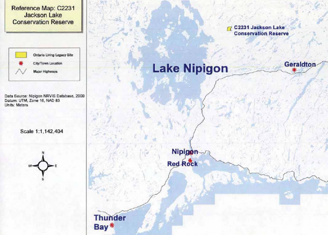
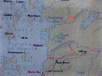
The Jackson Lake Conservation Reserve is located 75 kilometers northwest of the Town of Geraldton. Jackson Lake is part of a chain of lakes which include, from north to south, Elbow Lake, Jackson Lake, Todd Lake and Ledingham Lake. The area is comprised of weakly to moderately broken bedrock with thin and often discontinuous till veneers. Fluvial lacustrine materials are also present. Two organic complexes occur as well. It supports a diversity of upland forest and wetland vegetation types.
- Name: Jackson Lake Conservation Reserve
- Site Ecoregion / Site Ecodistrict: White Water Lake (3W-1)
- OMNR Administrative Region / District / Area: Northwest / Nipigon / Terrace Bay-Nipigon East Area
- Total Area (ha): 1166 ha
- Regulation Date: June, 2000
- Interested First Nations: Lake Nipigon Ojibway; Rocky Bay; Sand Point
- OBM: 16 4400 55400
- Latitude/Longitude: 50 05′00″ / 87 48′ 00″
- Basemap: 44554 (1985)
- FRI Stands: 20,23, 24, 25, 26,27, 29, 30, 31, 32, 35, 38, 62, 63, 64, 66, 67, 68, 69, 70, 71, 72, 73, 74, 75, 225, 226, 227, 228, 232, 233, 234, 235, 237, 238, 239, 240, 244, 245, 249, 250, 251, 255, 256, 257, 258, 259, 260, 261, 262, 264, 265, 267. N.B.: These stands either fully or partly fall in the conservation reserve.
- General Local Description: Located 75 kilometres west of the Town of Geraldton, between Lake Nipigon and Onaman Lake.
- Access: Lakes immediately adjacent to the area are accessible by aircraft, canoe and portage. Immediately adjacent areas the conservation reserve are also accessible by motor vehicle.
3. Representation targets
This section provides a summary of the earth science, life science and cultural resource values represented. It also outlines existing and potential recreational opportunities available.
Life science representation
Regionally significant mature coniferous and mixed wood forest. Representative of upland areas within Site Ecodistrict 3W-1.
Earth science representation
Representative of weak to moderately broken bedrock, fluvial lacustrine sediments and thick organic accumulations. The fluvial lacustrine sediments represent the eastern extent of glacial Lake Kelvin.
Cultural resource representation
No documented cultural resources
Recreational opportunities
Opportunities exist for wildlife viewing, fishing and hunting. Boating and canoeing opportunities are present on the eastern edge of the conservation reserve.
4. Survey information
This section provides an overview of the inventories completed. Their level of detail and any further inventories needed.
| Survey Level | Life Science | Earth Science | Cultural | Recreational | Other |
|---|---|---|---|---|---|
| Reconnaissance | Yes. February, 2001 | Yes. February, 2001 | Yes | Yes | N/A |
| Detailed | No | No | No | No | N/A |
| Requirement | No further requirement | No further requirement | No further requirement | No further requirement | N/A |
5. Values to be protected
This section provides a description of the key natural heritage values on the site and their condition relative to past resource use and management activities. It also addresses the sensitivity of these values to future land use and management activities.
- Cultural: None identified
- Aboriginal: Trapping, traditional hunting and gathering
- Tourism: No known tourism uses.
- Recreational Fishing: No significant streams or lakes present within the conservation reserve, however Jackson Lake which shows significant use is immediately adjacent to the east boundary of the conservation reserve
- Recreational Hunting:
Some potential – access into the conservation reserve would be by foot only. However, water access is available along most of the eastern boundary. We observed hunters setting up camp near Jackson Lake in October 2000. Bear Management Area NG-19-097 contains the Conservation Reserve.
- Mining: No active claims, staking or exploration in the conservation reserve. The area has been withdrawn from staking by means of a withdrawal order.
- Aggregate: None observed on site.
- Forest Harvest: Mature forest cover on the site is commercially merchantable.
- Wild Rice: None observed on site
- Trapping: Trapline NG85 contains the conservation reserve.
- Wildlife:
Habitat conditions exist for moose, bear and furbearers. Bedrock knolls and associated lichen could provide winter habitat for woodland caribou. The field crew observed evidence of moose presence during reconnaissance surveys.
- Commercial Fisheries:
None present. There is one baitfish block.
The intent of this Statement is to protect those values identified on site by establishing guidelines for existing and potential uses in this area, given the level of past disturbances and the nature of existing features.
Forest Values – The entire forest area is to be protected (including the Old Growth component) from human disturbance. The forest cover on this site is representative of the surrounding area and is predominately fire origin mature stands.
Recreational Values – The site offers few opportunities for heavy recreational use due to the lack of road or water access into the conservation reserve. Some potential exists for hunting and wildlife viewing.
Tourism Values – There is little evidence of traditional tourism use within the site. The site houses a population of moose, bear and grouse which could support tourism based hunting.
First Nation Values – There is little evidence of current use of this site for traditional bunting, gathering or cultural activities. MNR has no records that would indicate the levels of historical use for these activities.
6. Management guidelines
The following topics briefly indicate the existing situation on Jackson Lake Conservation Reserve and the management guidelines to be implemented or continued.
6.1 Land tenure
Jackson Lake Conservation Reserve consists entirely of Crown Land. The conservation reserve has been permanently withdrawn from any mineral exploration and from disposition by sale or Crown Lease or Land Use Permit. Land tenures of any type will not be considered within the conservation reserve boundaries.
6.2 Existing and proposed development
There are no existing facilities within the Conservation Reserve. New development that would disturb the forest or the forest understory vegetation will not be permitted. The area will be managed primarily for public nature appreciation, educational experiences and scientific study. Tourism will not be promoted for this area due to potential site degradation.
6.3 Recreational activities
Low intensity, non-structural recreational activities that do not impact the health of the forest ecosystem (e.g. viewing, hiking, bunting, etc.) arc permitted. ATV access and snowmobile usage will be closely monitored for possible damage to the trees and site regeneration component. If site degradation occurs these activities may have to be excluded from the area. Access by non-mechanized means is the preferred method.
6.4 Commercial activities
The site forms a part of an active trapline. Trapping will continue as a permitted use. The site also falls within a Bear Management Area and a Bait Fish Harvest Licence Area. Both of these uses will be permitted with the condition that no new trails or other development are allowed without specific authorization.
No other commercial activities exist within the Conservation Reserve boundaries and no new ones will be permitted (i.e. mining, hydroelectric development, logging, aggregate extraction. road development, utility corridors, peat development and topsoil removal). Careful .mineral exploration may occur in specific new Conservation Reserves proposed through Ontario’s Living Legacy Land Use Strategy, in areas that have provincially significant mineral potential. If a portion of the new Conservation Reserve is to be developed for a mine, it would be removed from the reserve and appropriate replacement lands would be placed in regulation.
The area has been permanently removed from the operable area of the Lake Nipigon Forest Sustainable Forest Licence. The site has been withdrawn from areas available to mining exploration and extraction activities.
6.5 Aboriginal interests
Lake Nipigon Ojibway First Nation indicated that a member of their community has a trapline in the Conservation Reserve They indicated that they are not concerned, as trapping will be permitted to continue. Nothing in this Statement of Conservation Interest affects in any way existing or future aboriginal or treaty rights. These rights will continue to be respected.
6.6 Natural resources stewardship
6.6.1 Vegetation management
MNR recognizes fire as an essential ecosystem process, fundamental to restoring and maintaining the ecological integrity of protected areas in the Boreal Forest Region. Fire management involves the protection of values and the attainment of resource management objectives through fire response and fire use. The Forest Fire Management Strategy for Ontario (OMNR 2004) provides strategic direction for the management of wildfire across Ontario. Jackson Lake Conservation Reserve is in the Boreal Fire Management Zone according to this provincial strategy. Fire management objectives within the CR will focus on preventing personal injury, value loss and social disruption. As well as using fire management techniques to perpetuate naturally occurring vegetation communities and help to restore and maintain ecological integrity. Fires that pose a threat to public health and safety, property and infrastructure, or other values will receive a full response and sustained action. “Light on the land” fire suppression techniques will be used whenever feasible. These minimal impact suppression techniques do not unduly disturb natural or cultural values. Examples may include limiting the use of heavy equipment or the felling of trees during fire response.
6.6.2 Fish and wildlife management
Fishery and wildlife will continue to be managed in accordance with existing policies and regulations. Opportunities for wildlife viewing will be encouraged.
6.6.3 Landforms
No management requirements except continued protection
6.7 Cultural resource stewardship
No requirements at this time based on existing information. The Ministry of Natural Resources will continue to work with the Ministry of Tourism and Culture’s regional chief archaeologist in identifying archaeological sites which should be further protected.
6.8 Client services
Nipigon District and the Information Management Team staff will be the primary contact for responding to inquiries about the basic level of information such as access, nature appreciation, scientific study requests, wildlife viewing opportunities, hunting, permitted uses and boundaries.
6.9 Research
Non-destructive scientific research by qualified/recognized Canadian institutions or organizations that will contribute to the Ministry of Natural Resources natural heritage information base will be encouraged. All research programs will require the approval of the Ministry of Natural Resources and will be subject to ministry policy and other relevant legislation.
6.10 Marketing
No requirements at this time.
7. Implementation
Implementation of this Statement of Conservation Interest will primarily involve monitoring activities to ensure adherence to management guidelines. Other activities will involve producing a fact sheet highlighting the importance of the reserve and responding to inquiries about the site. Any affected clients will be immediately notified of any amendments to this Statement of Conservation Interest.
The Jackson Lake Conservation Reserve has been regulated in June, 2000 under the Public Lands Act, following the process set out in the Ontario’s Living Legacy Protected Areas Regulation Implementation Manual (MNR, 2000), and is now governed by the Provincial Parks and Conservation Reserves Act (2006).
8. Review and revisions
Any changes that may occur to the management direction outlined in this Statement of Conservation Interest for Jackson Lake will be evaluated for their significance. Minor changes which do not alter the overall protection objectives, may be considered and approved by the Area Supervisor. Local consultation may also be required, as determined by the Area Supervisor. In the case of major changes, the need for a more comprehensive Conservation Reserve Management Plan will be considered first along with any legislative notification requirements (such as the Environmental Bill of Rights Registry notification) that may exist at that particular time. Any major amendments will require full public consultation and the approval of the District Manager and Regional Director.
In accordance with the Provincial Parks and Conservation Reserves Act (2006), MNR will annually examine management direction documents that have been in place for 20 years or more. The next scheduled examination for the Jackson Lake Conservation Reserve will be in 2021.
9. Public consultation
9.1 Results of past consultation
Jackson Lake has been a part of the consultation process from early in the land use planning process:
- Lands for Life round table consultation (June 1997 to July 1998)
- Ontario Forest Accord (1999)
- Ontario’s Living Legacy round table discussions (1999)
- OLL Site Regulation Public Consultation Process (Fall 1999 to Early 2000)
Under the Ontario’s Living Legacy Land Use Strategy, contact was made with stakeholders. District Manager letters were sent to First Nations, forest industry, trappers, municipalities, landowners, prospectors, fish and game clubs, trail clubs and tourist operators in November !999. Newspaper advertisements were distributed during this time. Two written comments were received regarding Jackson Lake Conservation Reserve (See Appendix). Lake Nipigon Ojibway First Nation representatives indicated that a community member has a trapline within the reserve. Concerns that arose with respect to the establishment of the conservation reserve were addressed accordingly.
9.2 Present and future consultation
Further widespread consultation is not deemed necessary at this time because of the extensive consultation that has occurred to date.
10. References
Ontario Ministry of Natural Resources. 1999. Ontario’s Living Legacy Land Use Strategy. Queen’s Printer for Ontario, Ontario Canada.
Ontario Ministry of Natural Resources. 2000. Protected Areas Regulation Implementation Manual, Internal Document.
Ontario Ministry of Natural Resources. 2009. Ontario’s Woodland Caribou Conservation Plan. Queen’s Printer for Ontario. 28 pp.
Ontario Ministry of Natural Resources. 2011. Ontario Protected Areas Planning Manual. Peterborough. Queen’s Printer for Ontario. 50 pp.
Appendix 1 – Key map
Appendix 2 – Map of Jackson Lake Conservation Reserve
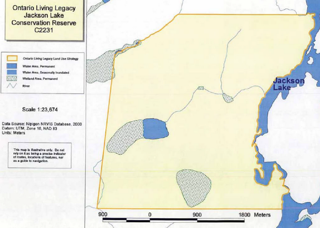
Enlarge Appendix 2 – Map of Jackson Lake Conservation Reserve
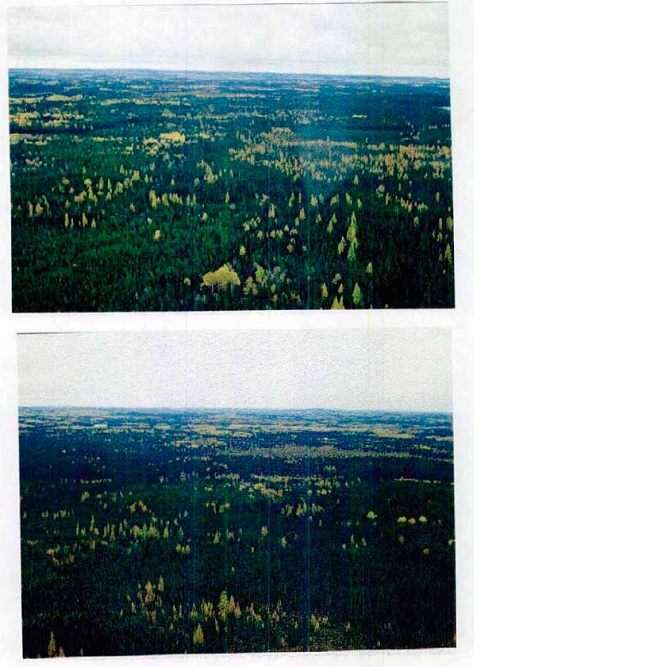
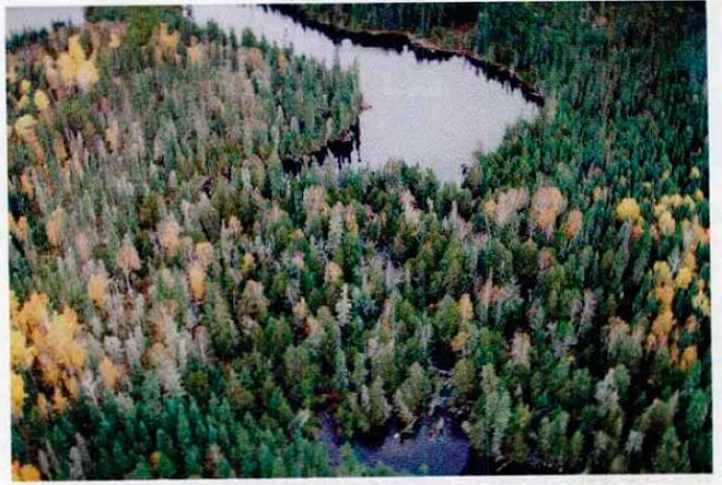
Appendix 3 – Photographs
Appendix 4 – Earth science report
- Name: Jackson Lake (C2231)
- Map name: Elbow Lake
- NTS No.: 42L04
- UTM Reference: 5545000N 443000E
- OBM No.: 164405540
- Latitude: 50°03′
- Longitude: 87°56′
- Elevation (Max): 350 m
- Elevation (Min): 300 m
- Country: NA
- Township:NA
- Concession/lot: NA
- Area: 1166 ha
- Ownership: Crown
- Air photos: 95-A-5002 42 - 46, 47, 48 and 49
95 - A - 5003 42 - 82, 83 and 84 - MNR Region: Northwest
- MNR District: Nipigon
- Park Zone: Northwest
- Survey Type: Reconnaissance
Earth science features
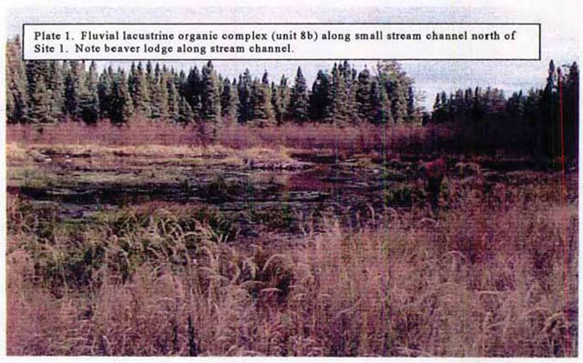
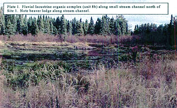
The Jackson Lake Conservation Reserve (C2231) is situated 75 km northwest of Geraldton, Ontario. It is a relatively small area (1,166 ha) with local relief of less than 20 - 35 m. Jackson Lake is part of a chain of lakes running in a north-south pattern. From north to south, the following lakes occur; Elbow Lake, Jackson Lake, Todd Lake and Ledingham Lake. With the exception of the extreme southeast comer of the Conservation Reserve, Jackson Lake forms the eastern boundary of the Conservation Reserve; Gzowski Creek and Todd Lake occur in the southeast comer. Onoman River that drains into Humboldt Bay of Lake Nipigon drains Jackson Lake to the south. The area is comprised of weakly to moderately broken bedrock with thin, and often discontinuous till veneers. Fluvial lacustrine materials were noted, as well. Two large organic complexes occur in the southern and western portion of the reserve.
The Jackson Lake Conservation Reserve is found within the Wabigoon Subprovince of the Superior Structural Province (Card et al. 1993; Ontario Geological Survey 1991a). The Superior Province is the largest Archean craton in the world and is characterized by easterly trending belts of Archean supracrustal volcanic and sedimentary rocks separated by large areas of granitic rocks (Thurston 1992b; Davidson 1981). The Wabigoon Subprovince is 900 km long, east-trending a granite-greenstone subprovince composed of metavolcanic and subordinate metasedimentary rocks which are surrounded and cut by granitoid batholiths, gabbroic sills and stocks. The Wibigoon Subprovince is divided into three parts based on geographic distribution of lithological associations. The Jackson Lake area occurs in the Eastern Wabigoon Region, an area underlain by supracrustal rocks and lobate intravolcanic granitoid batholiths (Blackburn et al., 1992, Ontario Geological Survey 1991a).
Pye et al. (1966) provides the most detailed (1:253 440) bedrock geology map of the Seahorse Lake Conservation Reserve. He suggests that two distinct types underlie the area, with a line running from the northeast comer in a south-westerly direction to the southwest comer. To the cast of this line, basic and intermediate metavolcanic consists of greenstone, basalt, pillow lava, metadiabase, andesite, dacite, amphibolite, chlorite, schist, hornblende schist, tuff and agglomerate. To the west of this line acid igneous and metamorphic rocks occur, including granite, gneiss, and granodiorite. This mapping is in agreement with more detailed mapping (1:31 680) conducted by Thurston (1978, 1980) to the immediate east, Amukun (1977) to the north and by Card et al., (1989).
Both Barnett (1992) and Prest (1968) suggests that the Jackson Lake area was overlain with Labrador Sector Laurentide ice until - 9 ka BP (early Holocene). Prest (1968) provides a more detailed glacial history of the area with lite ice front being stationed over the area around 10.3 ka BP and re-advancing in a south-westerly direction around 10 ka BP (initiation of Holocene; and corresponding with Davidson’s (1981) Algonquin Stadial). Around 9.5 ka BP, the ice front retreated across the area with glacial Lake Kelvin covering lands to the immediate west in the vicinity of Humboldt Bay (this corresponds to Davidson’s (1991) Timiscaming Interstadial). Around 9 ka BP, the ice front bad retreated further to the northeast in the vicinity of O’Sullivan Lakes. Glacial Lake Nokina formed along this ice margin. Zoltai (1965) implies that the bedrock in the area has been eroded by lake action, thereby giving speculation that glacial Lake Kelvin may have extended to Jackson Lake area.
Table 1 provides a comparison of materials identified in the gap analysis versus materials identified during the reconnaissance field inventory and subsequent air photo interpretation exercise.
| Landform types: Parent Material | Landform types: Surface Expression | Landform Types by Gap analysis | Landform Types Found During Reconnaissance Inventory and Mapping |
|---|---|---|---|
| Ground Moraine | Weakly broken | Yes | N/A |
| Ground Moraine | Moderately broken | N/A | N/A |
| Ground Moraine | Strongly broken | N/A | N/A |
| Bedrock | Weakly broken | Yes | Yes |
| Bedrock | Moderately broken | Yes | Yes |
| Bedrock | Strongly broken | N/A | N/A |
| End Moraine | Weakly broken | N/A | N/A |
| End Moraine | Moderately broken | N/A | N/A |
| End Moraine | Strongly broken | N/A | N/A |
| Outwash Deposits | Weakly broken | N/A | N/A |
| Outwash Deposits | Moderately broken | N/A | N/A |
| Outwash Deposits | Strongly broken | N/A | N/A |
| Beach/Aeolian Deposits | Weakly broken | N/A | N/A |
| Lacustrine Deposits | N/A | N/A | Yes |
| Esker | N/A | Yes | N/A |
Research by Zoltai (1965) suggests that the Jackson Lake Conservation Reserve consists mainly of bedrock which has been eroded by lake action and lesser amounts of silty to sandy till. This is supported by Cooper (1981), and Barnett et al. (1991). Field work undertaken by Geowest during early October, 2000 suggests that the area is comprised of mainly fluvial lacustrine deposits (unit 4b on accompanying surficial geology map) in low lying areas between weakly to moderately broken bedrock with thin, often discontinuous morainal (and perhaps fluvial lacustrine) veneers (units 7b and 7d). Two large wetland areas have been mapped (unit 8c).
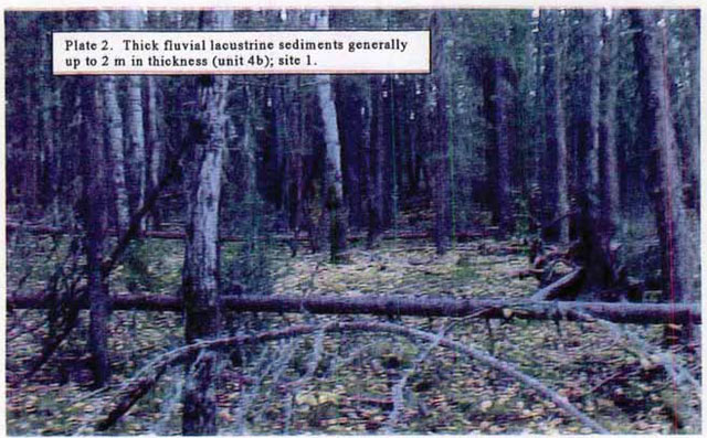
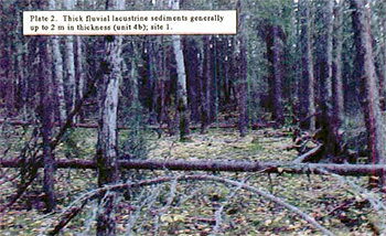
The fluvial lacustrine sediments occurring in low-lying topography are highly variable in texture. Loamy sands are dominant with sandy clay looms at the surface and pockets of gravely sand intermixed throughout the soil matrix. The coarse fragment content varies from stone free to 20 % subrounded and rounded gravels. These deposits are moderately well to well drained. In exploration work, Mason et al. (J 980) found these sediments to be between 1-2 m in thickness.
Weakly to moderately broken bedrock knobs are scattered throughout the Conservation Reserve. Local relief within these units is generally less than 35 m. Slopes vary from 0-5% on weakly broken topography to I 5 - 30 % on more rugged moderately broken topography. For the most part, these knobs are ove£1ain with a very thin, most likely loamy sand morainal veneer. It is anticipated that in the more subdued topography, the bedrock is overlain with discontinuous fluvial lacustrine sediments. Drainage in these areas is well to rapidly drained.
Two major wetlands occur within the Conservation Reserve. These organics tend to be well developed and are most likely greater than 100 cm in depth. Drainage in these areas is poor to very poor.
Field survey
The Jackson Lake Conservation Reserve was inventoried on October 6, 2000. Only one (1) site was established in the area. Access was provided by helicopter. A surficial geologist (Dennis O’Leary), a vegetation ecologist (Jerry Bentz), and a wildlife biologist (Amit Saxena) completed lite reconnaissance inventory). All three individuals are from Geo Environmental Consultants Ltd. An accompanying life science checklist has been completed for the Jackson Lake Conservation Reserve.
Mapping
A reconnaissance surficial geology map bas been prepared for the Jackson Lake Conservation Reserve at 1:20 000 to accompany this checklist The mapping legend follows Zoltai’s (1965a) classification scheme, however it has been modified somewhat to account for additional parent materials and topographic considerations.
Sensitivity
The Jackson Lake Conservation Reserve can only be accessed by helicopter. No roads or trails exist into the area; however, numerous trails do exist to the east of Jackson Lake. With the exception of the wetlands, the area is not considered to be overly sensitive to disturbances as weakly to moderately broken bedrock and thick, well drained fluvial lacustrine sediments dominates the landscape. The organics are highly sensitive to disturbances and should be avoided.
Significance
The Jackson Lake Conservation Reserve has been designated as regionally significant as it provides representative examples of weak to moderately broken bedrock, fluvial lacustrine sediments and thick organic accumulations typical of the Wabigoon Subprovince.
Recommendations
The Jackson Lake Conservation Reserve should be protected as a Conservation Reserve as it provides representative examples of weak to moderately broken bedrock, fluvial lacustrine sediments and thick organic accumulations typical of the Wabigoon Subprovince of the Superior Structural Province. The fluvial lacustrine sediments may represent the eastern extent of glacial Lake Kelvin (as suggested by Prest 1968). These sediments are from the early Holocene Timiscaming Interstadial (~9.5 ka BP). Because of its isolation the area can be easily protected from future disturbances.
References
Amukun, S.E. 1977. Geology of the Tashota Area, District of Thunder Bay. Ontario Geological Survey Report 167. Scale 1:31 680. Ontario Ministry of Natural Resources.
Barnett, P.J. 1992. Quaternary geology of Ontario; In Geology of Ontario, Ontario Geological Survey, Special Volume 4, Part 2, Ontario Ministry of Northern Development and Mines. p. 1011-1088.
Barnett, P.J., A.P. Henry and D. Babuin. 199L Quaternary geology of Ontario, west-central sheet; Ontario Geological Survey, Map 2554, scale 1:1 000 000. Ontario Ministry of Northern Development and Mines.
Blackburn, C.E., G.W. Johns, J. Ayer and D.W. Davis. 1992. Wabigoon Subprovince; in Geology of Ontario, Ontario Geological Survey, Special Volume 4, Part l, Ontario Ministry of Northern Development and Mines. p.303 -381.
Card, K.D., J.A. Percival and B.V. Sanford. 1993. Bedrock Geology Lake Nipigon Ontario - USA, Map NM-16-G, Scale 1:100 000. Geological Survey of Canada, Energy, Mines and Resources Canada.
Cooper, A.J. 1981. Northern Ontario Engineering Geology Terrain Study, Data Base Map, Onaman Lake. Map 5124. Ontario Geological Survey. 1:100 000. Ontario Ministry of Natural Resources.
Davidson. R.J. 1981. A framework for the conservation of Ontario’s earth science features. Ontario Ministry of Natural Resources.
Ontario Geological Survey. 1991(a). Bedrock Geology of Ontario, Explanatory Notes and Legend. Map 2545. Ontario Ministry of Northern Development and Mines.
Ontario Geological Survey. 1991(b). Bedrock Geology of Ontario, West-Central Sheet. Map 2542. Ontario Ministry of Northern Development and Mines.
Ontario’s Living Legacy. 1999. Ontario’s Living Legacy Land Use Strategy July 1999. Ontario Ministry of Natural Resources.
Prest, V.K. 1968. Quaternary geology of Canada in Geology and Economic Minerals of Canada. R.J.W. Douglas. Scientific Editor. Geological Survey of Canada, Department of Energy, Mines and Resources. Economic Geology Report No. 1. pp. 676 -758.
Pye, B.G., F.R. Harris, K.G. Fenwick and J. Baillie. 1966. Tashota - Geraldton Sheet Geological Compilation Series, Thunder Bay and Cochrane District Map 2102, Scale 1:253 440.
Stott, GM., D. Morrison, V. Gale; and N. Waebowiak.. 1996. Precambrian geology of South-Central OnamanTashota Greenstone Belt Ontario Geologic Survey, Preliminary Map P.3352, scale 1:50 000.
Sutcliffe, R.H. 1992. Proterozoic geology of the Lake Superior Area; in Geology of Ontario, Ontario Geological Survey, Special Volume 4, Part 1. P. 627-678.
Thurston, P.C. 1992(a). Geology of Ontario: Introduction; In Geology of Ontario, Ontario Geological Survey, Special Volume 4, Part I, Ontario Ministry of Northern Development and Mines. p. 2 -26.
Thurston, P.C. 1992(b). Proterozoic Geology of Ontario: Introduction. in Geology of Ontario, Ontario Geological Survey, Special Volume 4, Part 1, Ontario Ministry of Northern Development and Mines. p. 543 -546.
Thurston, P.C. 1980. Geology of the northern Onaman Lake area, District of Thunder Bay. Ontario Geological Survey Report 208. Ontario Ministry of Natural Resources.
Thurston, P.C. 1978.Onaman Lake; Ontario Geological Survey map 2411, Precambrian Geology Series, Scale 1:31 680.
Thurston, P.C., H.R. Williams, R.R. Sutcliffe and G.M. Stott l992.Geology of Ontario. Ontario Geological Survey, Special Volume 4,Parts land 2. Ontario Ministry of Northern Development and Mines.
Zoltai, S.C. 1965. Surficial Geology, Thunder Bay, Map S265 Scale 1:506 880. Ontario Department of Lands and Forests, Research Branch.
Date Completed: November 30, 2000
Compiler: Dennis O’Leary, B.A.,
Surficial Geologist. Geowest Environmental Consultants Ltd.
List of Plates:
Plate 1. Fluvial lacustrine organic complex.
Plate 2. Thick fluvial lacustrine sediments.
Field Notes:
Site: Jackson Lake (C2231) - Plot No. 1 - Date: October 6, 2000
UTM Coordinates: 554501N and 443030E
Picture No. Disk 7, picture 14 Surveyor: Dennis O’Leary, Geowest Environmental Consultants Ltd.
Notes: Fluvial-lacustrine sediments; gently undulating topography with slopes to 9%; materials highly variable - loamy sand textures with sandy clay loams (~10 cm thick) to gravely sand (at bottom) pockets in matrix; coarse fragment content varies from 0 - 20% subrounded and rounded gravels; depth to basalt > 70 cm; mesic; moderately well to well drained; basalt exposed in uplands (see photo); site accessed by helicopter; site representative of area; beaver disturbances.
Key words/glossary
- Archean
- A term, meaning ancient, which has been applied to the oldest rocks of the Precambrian; as more physical measurements of geologic time are made, the usage is changing; the term Early Precambrian is preferred.
- Batholiths
- A body of igneous rock, 100 square kilometres or more in area, emplaced at great or intermediate depth in the earth’s crust.
- Craton
- The large, relatively immobile portion of continents consisting of both shield and platform areas.
- Fluvial
- Pertaining to or produced by the action of a steam or river.
- Glaciation
- Alteration of any part of the earth’s surface by passage of a glacier, chiefly by glacial erosion or deposition.
- Greenstone belts
- Oceanic and island arclike sequences.
- Ground moraine
- Rock material carried and deposited in the base of a glacier; also known as bottom moraine, subglacial moraine.
- Holocene
- An epoch of the Quaternary Period from the end of the Pleistocene, around 10,000 years ago, to the present; also known as post-glacial; recent.
- Ka BP
- Thousand years before present.
- Lacustrine
- Belonging to or produced by a lake; sediments that are deposited in a lake.
- Landform
- All the physical, recognizable, naturally formed features of land, having a characteristic shape; includes major forms such as a plain, mountain, or plateau, and minor forms such as hill, valley, or alluvial fan.
- Lobe
- A curved projection on the margin of a continental ice sheet.
- Metamorphic rock
- The earth’s crust as well as being intruded by magma, is from time to time subjected to huge stresses which are sufficiently great to cause it to break to form faults, and also to bend forming folds; these forces are generally concentrated near to subduction zones; at these destructive plate margins, the rocks that form the plates are compressed, folded and heated; the result is a broad, linear zone of rocks which are altered, to varying degrees, by the high temperatures and pressures.
- Metasediment
- A sediment or sedimentary rock which shows evidence of metamorphism.
- Moderately broken
- Area of long moderate slopes, or of short steep slopes; differences in relative elevation less than 60 m; one third of area has stronger or weaker relief.
- Moraine
- An accumulation of glacial drift deposited chiefly by direct glacial action and possessing initial constructional form independent of the floor beneath it.
- Organic soil
- Any soil or soil horizon consisting chiefly of, or containing at least 30% of organic matter; examples are peat soils and muck soils; results from the activity of organisms such as the secretion of skeletal matter.
- Parent material
- The unconsolidated mineral or organic material from which the true soil develops.
- Pillow lava
- Any lava characterized by pillow structure and presumed to have formed in a subaqueous environment (underwater).
- Relief
- The configuration of part of the earth’s surface, with reference to altitude and slope variations and to irregularities of the land surface.
- Sedimentary rock
- A rock formed in the sea; sedimentary rocks are formed by processes which are active at the earth’s surface; includes
- Sill
- A tabular igneous intrusion that is oriented parallel to the planar structure of surrounding rock.
- Stocks
- Also known as pipe or chimney; a vertical, cylindrical ore body; a vertical conduit through the crust of the earth below a volcano, through which magmatic materials have passed.
- Strongly broken
- Area of long moderately steeps slopes, or of short steep escarpments; differences in relative elevations greater than 60 m; less than one third of area has weaker relief.
- Till
- Unsorted and unstratified drift consisting of a heterogeneous mixture of clay, sand, gravel, and boulders which is deposited by and underneath a glacier.
- Veneers
- Thickness of deposit generally less than 100 cm and landform takes general shape of underlying bedrock.
- Volcanic rock
- Finely crystalline or glassy igneous rock resulting from volcanic activity at or near the surface of the earth; also known as extrusive rock.
- Weakly broken
- Area of gentle slopes, generally below 5%; difference in relative elevation generally less than 15 m; less than a third of the area has stronger or weaker relief.
- Wisconsinan
- A period between 115,000 years before present and 10,000 years before present; preceding the Holocene; divided into three stages, including Early Wisconsinan (115,000– 60,000 years before present), Middle Wisconsinan (60,000-30,000 years before present and Late Wisconsinan (30,000-10,000 years before present).
Appendix 5 – Life science report
Natural Heritage Area - Life science checksheet
- Name: Jackson Lake Conservation Reserve (C2231)
- Map name: Elbow Lake
- Map No.: 42L04
- UTM Reference: 5545000N 443000E
- County: N/A
- Latitude: 50°03’
- Longitude: 87°56’
- NAD: 27
- Minimum altitude: 300 m
- Maximum altitude: 350 m
- Country: N/A
- Township: N/A
- Area: 1166 ha
- Ownership: Crown
- MNR Region: Northwest
- Ecoregion and ecodistrict: 3W-3
- Landform Unit(s): Weakly to Moderately Broken Bedrock.
- MNR District: Nipigon
Physical and biological features
Representation
The Jackson Lake Conservation Reserve (C2231) is located approximately 75 km northwest of the Town of Geraldton, Ontario. The site is relatively small in size (1166 ha), with Jackson Lake forming the eastern boundary. Jackson Lake is one of a chain of lakes running in a north-south direction. The lakes in the complex include Elbow Lake, Jackson Lake, Todd Lake and Ledingham Lake. The lake complex is drained by the Onaman River, which drains into Humboldt Bay of Lake Nipigon.
The area is comprised of a diversity of upland forest and wetland vegetation types on a variety of landforms. Forested communities occur on upland terrain throughout the site, including significant areas witl1 weakly to moderately broken bedrock overlain by thin (often discontinuous) morainal materials, as well as areas dominated by somewhat thicker fluvial lacustrine deposits on subdued, low relief terrain. Bedrock knobs and ridges occur to a limited extent, especially in the eastern portion of the Conservation Reserve. Depressional sites have accumulations of organic materials of variable thickness.
Small stands and patches of deciduous-dominated mixedwood forest occur on upland, well drained sites scattered throughout the Conservation Reserve. Either trembling aspen or white birch typically dominates Forest stands. Trembling aspen mixedwood stands (Vegetation Type V9 - Trembling Aspen Mixedwood; see Sims et al. 1997) generally have a variable component of associated tree species such as white birch, white and black spruce, balsam fir and jack pine. The understory is generally shrub and herb rich, comprised of species such as Diervilla lonicera, Alnus crispa, Vaccinium myrtilloides. Cornus canadenis, Aster macrophyllus, Linnoea borealis, Rubus pubescens, Lycopodium spp.. and Clintonia borealis. Moss cover is generally low with occasional patches of feathermosses such as Pleurozium schreberi and Ptillum crista-Castrensis.
Small areas of white birch dominated mixedwood Stands (Vegetation Type V4 - White Birch Hardwood and Mixedwood) also occur to a very limited extent in the Conservation Reserve. Canopy associates are white and black spruce and balsam fir. The understory cover is variable but is often dominated by species such as Alnus crispa, Vaccinium spp.., Diervilla lonicera, Cornus canadensis, Lycopodium spp., Clintonia borealis and Aster macrophyllus
Extensive subdued, low-lying terrain with discontinuous morainal or fluvial lacustrine deposits typically supports coniferous forest Stands dominated by either black spruce or jack pine. Sites with well to moderately well drained soils tend to support forest stands dominated by jack pine, with lesser amounts of black spruce and occasional balsam fir, trembling aspen or white birch (Vegetation Type V32 - Jack Pine - Black Spruce/Ericaceous Shrub/Feathermoss). The moderately diverse shrub and herb layers commonly have species such as Vaccinium myrtilloides, Ledum groenlandicum, Alnus crispa, Gaultheria hispidula, Cornus canadensis, Linnaea borealis, Lycopodium spp.., Aster macrophyllus and Clintonia borealis. A mostly continuous feathermoss mat generally covers the forest floor. Occasional bedrock knolls typically have an aburulam cover of various reindeer lichen (Cladina) species.
Stands dominated by black spruce tend to occur on upland sites with moderately well to imperfectly drained soils, and generally have a lesser component of jack pine with occasional occurrences of balsam fir, white birch and aspen (Vegetation Type V31 - Black Spruce - Jack Pine/Tall Shrub/Feathermoss). The understory is generally sparse and dominated by ericaceous shrub species and herbs such as Cornus canadensis and Lycopodium spp.. Ground cover generally consists of an extensive feathermoss carpet.
Poorly drained depressional or lowland sites with thick organic veneers overlying morainal or lacustrine deposits are generally dominated by black spruce with occasional occurrences of balsam fir and tamarack (Vegetation Type V31 - Black Spruce/ Labrador Teal Feathermoss (Sphagnum)). Ericaceous species typically dominate the understory with a prevalence of Ledum groenlandicum, Vaccinium myrtilloides, and Gaultheria hispidula. Common herbaceous species, with generally lower cover, include Cornus canadensis, Lycopodium spp., Coptis trifolia, Linnaea borealis and Carex spp. The forest floor is primarily covered by a continuous mat of feathermoss with patches, often extensive of Sphagnum spp.
Open wetland communities (Poor Fens) occur in poorly to very poorly drained depressional sites with thick organic deposits. Species composition is variable but common tree species include scattered, stunted black spruce and deposits and occasional white birch, as well as species such as Chamaedaphne calyculata, Kalmia polifolia, Andromeda glaucophylla, Ledum groenlandicum, Carex spp., Equisetum spp., Eriophorum spp. and Sphagnum spp.
Table 1 provides a comparison of landform vegetation types identified in the gap analysis versus what was found during the reconnaissance field inventory program and through reviewing the forest cover maps and air photographs.
| Landform types: Parent Material | Landform types: Surface Expression | Deciduous | Deciduous mixed | Conifer mixed | Conifer | Sparse forest | Treed wetland | Open wetland | Vegetated bedrock | Burn |
|---|---|---|---|---|---|---|---|---|---|---|
| Ground Moraine | Weakly broken | N/A | N/A | N/A | N/A | N/A | N/A | N/A | N/A | N/A |
| Ground Moraine | Moderately broken | N/A | N/A | N/A | N/A | N/A | N/A | N/A | N/A | N/A |
| Ground Moraine | Strongly broken | N/A | N/A | N/A | N/A | N/A | N/A | N/A | N/A | N/A |
| Bedrock | Weakly broken | N/A | yes | yes | yes | N/A | N/A | N/A | N/A | N/A |
| Bedrock | Moderately broken | N/A | yes | yes | yes | yes | N/A | N/A | yes | N/A |
| Bedrock | Strongly broken | N/A | N/A | N/A | N/A | N/A | N/A | N/A | N/A | N/A |
| End Moraine | Weakly broken | N/A | N/A | N/A | N/A | N/A | N/A | N/A | N/A | N/A |
| End Moraine | Moderately broken | N/A | N/A | N/A | N/A | N/A | N/A | N/A | N/A | N/A |
| End Moraine | Strongly broken | N/A | N/A | N/A | N/A | N/A | N/A | N/A | N/A | N/A |
| Outwash Deposits | Weakly broken | N/A | N/A | N/A | N/A | N/A | N/A | N/A | N/A | N/A |
| Outwash Deposits | Moderately broken | N/A | N/A | N/A | N/A | N/A | N/A | N/A | N/A | N/A |
| Outwash Deposits | Strongly broken | N/A | N/A | N/A | N/A | N/A | N/A | N/A | N/A | N/A |
| Beach/Aeolian Deposits | Weakly broken | N/A | N/A | N/A | N/A | N/A | N/A | N/A | N/A | N/A |
| Lacustrine Deposits | N/A | N/A | N/A | yes | yes | N/A | yes | yes | N/A | N/A |
| Esker | N/A | N/A | N/A | N/A | N/A | N/A | N/A | N/A | N/A | N/A |
Gap analysis suggests that particular landform/vegetation (LV) type occurs within study area.
Yes - Indicates that LV type found within study area during reconnaissance survey.
Condition
The Conservation Reserve is generally undisturbed with no road or trail access. No forest harvesting has occurred within the Conservation reserve; however, extensive logging and access road development is evident immediately to the east of Jackson Lake.
Diversity
A variety of landform/vegetation complexes occur within the Jackson Lake Conservation Reserve. Also present is a small water body and associated wetlands (see Table 1). Upland forests are comprised of a variety of deciduous, deciduous mixed, conifer and conifer mixed stands. Sparsely vegetated bedrock outcrops occur sporadically throughout the site. Landform types represented include weakly to moderately broken bedrock with thin, often discontinuous morainal veneers, pockets of thicker fluvial lacustrine materials, and organic deposits of variable thickness. Various wetland communities are represented, varying from semi-treed fens to marsh and open water marsh communities. Several small fluvial channels are also present.
Ecological considerations
Vegetation cover within the site is characteristic of the surrounding area and is predominantly fire-origin, mature forest. Soil thickness and drainage tend to influence forest species composition, with coniferous-dominated stands being more prevalent on cooler aspects, poorer drained depressional areas and areas with extensive bedrock outcrops and thin soils. Patches of deciduous dominated forest occur more commonly on warm aspects and upland sites with somewhat better soil drainage. Forest Stands tend to be fairly mature throughout the site, with few younger age classes represented. The site tends to be relatively undisturbed with no evidence of recent timber harvesting.
The diversity of vegetation and forest cover types provide an equally diverse assemblage of wildlife habitats. Deciduous-dominated mixedwood stands provide excellent moose forage opportunities, while coniferous-dominated mixedwood and pore coniferous stands afford thermal habitats. The presence of ericaceous shrubs in the understory of mixedwood forest components also provides good habitat for black bear and smaller furbearers. The bedrock knolls and associated lichen-dominated ground cover provides good winter micro-habitat for woodland caribou, which are reaching the southern limit of t11eir provincial range in the vicinity of Jackson Lake. OMNR records indicate that one registered trapline traverses the Jackson Lake Conservation Reserve, on which beaver, mink, marten, fisher, otter, and lynx were the reported catches.
The interspersion and juxtaposition of security, thermal, and foraging habitats for ungulates and forbearers is a key feature of this site. In addition, breeding bird diversity can be expected to be relatively high due to the diversity of habitats present.
Special features
No evidence of vulnerable, threatened or endangered species, or S ranked species were encountered during the reconnaissance survey of the site, however OMNR records indicate use of the site by woodland caribou.
Field survey
The Jackson Lake Conservation Reserve was inventoried on October 6, 2000. Only one ground site was surveyed in the area (via helicopter access). A surficial geologist, a vegetation ecologist and a wildlife biologist completed the reconnaissance inventory. An Earth Science Checklist has also been prepared for the Jackson Lake Conservation Reserve.
Major information sources
Baldwin, K.A. and R.A. Sims. 1997. Field guide to the common forest plants in northwestern Ontario. Ont. Min. Natur. Resour., Northwest Sci. & Technol. Thunder Bay, Ont. Field Guide FG-04. 359 pp.
Harris, A.G., S.C. McMurray, P.W.C. Uhlig, J.K. Leglum, R.F. Foster and G.D. Racey. 1996. Field guide to the wetland ecosystem classification for northwestern Ontario. Ontario Ministry of Natural Resources, Northwest Sci.& Technol. Thunder Bay, Ont. Field Guide FG-01. 74 pp. + Append.
Noble, T.W.1979. Life Science report, Phase II, Site Region 3W, North Central Region. Ontario Ministry of Natural Resources.
Sims, R.A., W.O. Town, K.A. Baldwin, P. Uhlig and G.M. Wickware. 1997. Field guide to the forested ecosystem classification for northwestern Ontario. Ont. Min. Natur. Resour., Northwest Sci. & Technol. Thunder Bay, Ont. Field Guide FG.03. 176 pp.
Field Reconnaissance, October 2000.
Ontario Ministry of Natural Resources trapline information for 1999.
Significance Level (Provincial/Regional/Local) and Brief Summary of Major Representative Values
Regionally Significant: The site provides a good example of mature coniferous and mixedwood forest on weakly to moderately broken bedrock overlain by thin (and often discontinuous) morainal materials. It is representative of upland areas within Site District 3W- 3.
Date Compiled: December 6, 2000
Compiler(s):
J. Bentz, A. Saxena, D. O’Leary
Geowest Environmental Consultants Ltd.
Jackson Lake Conservation Reserve (C2231) - Species listfootnote 1 .
Scientific name (common name)
Trees
Abies balsamea (Balsam Fir)
Betula papyrifera (White Birch)
Larix laricina (Tamarack)
Picea glauca (white spruce)
Picea mariana (black spruce)
Pinus banksiana (Jack Pine)
Populus tremuloides (Trembling Aspen)
Shrubs
Alnus crispa (green alder)
Amelanchier spp. (serviceberry)
Chamaedophne calculata (leather leaf)
Diervilla lonicera (bush honeysuckle)
Kalmia polifolia (bog laurel)
Ledum groenlandicum (Labrador tea)
Linnaea borealis (twinflower)
Salix spp. (willow)
Vaccinium myrtilloides (velvet leaf blueberry)
Viburnum edule (squashberry)
Herbs
Aster macrophyllus (large-leaved aster)
Clintonia borealis (blue bead lily)
Cornus canadensis (bunch berry)
Petasites palmatus (sweet coltsfoot)
Graminoids
Calamagrostis canadensis (blue-joint grass)
Carex spp. (sedge)
Ferns and fern-allies
Lycopodium annotinum (stiff clubmoss)
Lycopodium obscurum (ground pine)
Bryophytes and lichens
Cladina spp. (reindeer lichen)
Dicranum spp. (broom mosses)
Hylocomium splendens (stair-step moss)
Pleurozium schreberi (Schreber’s moss)
Ptilium crista-castrensis (plume moss)
Sphagnum spp.
| Substrate & temp: Moisture regime | Arid | Very dry | Dry | Dry mesic | Mesic | Wet Mesic | Wet | Very wet | Saturated | Open water |
|---|---|---|---|---|---|---|---|---|---|---|
| Colder: Rock | N/A | N/A | N/A | N/A | N/A | N/A | N/A | N/A | N/A | N/A |
| Colder: Sand | N/A | N/A | N/A | N/A | N/A | N/A | N/A | N/A | N/A | N/A |
| Colder: Loam | N/A | N/A | N/A | N/A | N/A | N/A | D | E | N/A | N/A |
| Colder: Clay | N/A | N/A | N/A | N/A | N/A | N/A | N/A | N/A | N/A | N/A |
| Colder: Organic | N/A | N/A | N/A | N/A | N/A | N/A | N/A | N/A | N/A | N/A |
| Normal: Rock | N/A | N/A | C | C | N/A | N/A | N/A | N/A | N/A | N/A |
| Normal: Sand | N/A | N/A | N/A | N/A | N/A | N/A | N/A | N/A | N/A | N/A |
| Normal: Loam | N/A | N/A | N/A | A | A,B | B,C | C,D | E | N/A | N/A |
| Normal: Clay | N/A | N/A | N/A | N/A | N/A | N/A | N/A | N/A | N/A | N/A |
| Normal: Organic | N/A | N/A | N/A | N/A | N/A | N/A | N/A | F | F,G | G,H |
| Warmer: Rock | N/A | C | C | N/A | N/A | N/A | N/A | N/A | N/A | N/A |
| Warmer: Sand | N/A | N/A | N/A | N/A | N/A | N/A | N/A | N/A | N/A | N/A |
| Warmer: Loam | N/A | N/A | A | B | N/A | N/A | N/A | N/A | N/A | N/A |
| Warmer: Clay | N/A | N/A | N/A | N/A | N/A | N/A | N/A | N/A | N/A | N/A |
| Warmer: Organic | N/A | N/A | N/A | N/A | N/A | N/A | N/A | N/A | N/A | N/A |
Community types
A: White Birch Hardwood and Mixedwood (V4)
B: Tremblin Aspen Mixwood (V9)
C: Jack Pine – Black Spruce/Ericeous Shrub/Feathermoss (V32)
D: Black Spruce/Tall Shrub/Feathermoss (Sphagnum) (V31)
E: Black Spruce/ Labrador Tea/Feathermoss (Sphagnum) (V34)
F: Poor Fen
G: Marsh
H: Open Water Marsh
Appendix 6 – Permitted uses table
| Activity/Value | Permitted | Not Permitted | Modified | District Manager Approval |
|---|---|---|---|---|
| Sport Hunting | Yes | N/A | N/A | N/A |
| Commercial Trapping | Yes | N/A | N/A | N/A |
| Boating / Canoeing / Kayaking | Yes | N/A | N/A | N/A |
| Baitfishing | Yes | N/A | N/A | N/A |
| Commercial Wild Rice Harvest | N/A | N/A | N/A | N/A |
| Mineral Exploration & Extraction | N/A | N/A | Yes | N/A |
| Land Disposition for Private Purposes | N/A | Yes | N/A | N/A |
| All-terrain Vehicle | N/A | N/A | Yes | N/A |
| Snowmobile | N/A | N/A | Yes | N/A |
| Land Claims | N/A | N/A | N/A | Yes |
| Traditional Use | Yes | N/A | N/A | N/A |
| Native Hunt Camps | N/A | N/A | N/A | Yes |
| Commercial Tourism Based Hunting | Yes | N/A | N/A | N/A |
| Native Hunting | Yes | N/A | N/A | N/A |
| Commercial Native Trapping | Yes | N/A | N/A | N/A |
| Wildlife Management | Yes | N/A | N/A | N/A |
| Commercial Forest Operations | N/A | Yes | N/A | N/A |
| Vegetation Management (i.e. herbicides) | N/A | Yes | N/A | N/A |
| Timber Harvest for Personal Use | N/A | Yes | N/A | N/A |
| Fuelwood Harvest | N/A | Yes | N/A | N/A |
| Insect & Disease Suppression | N/A | N/A | N/A | Yes |
| Sport Fishing | Yes | N/A | N/A | N/A |
| Commercial Fishing | N/A | N/A | N/A | N/A |
| Native Fishing | Yes | N/A | N/A | N/A |
| Water Control Structures | N/A | Yes | N/A | N/A |
| Aggregate Extraction | N/A | Yes | N/A | N/A |
| Bear Management Areas | Yes | N/A | N/A | N/A |
| Trapline Cabins | N/A | N/A | N/A | Yes |
| Wild Rice Harvest | N/A | N/A | N/A | N/A |
| Boat Caches | N/A | N/A | N/A | Yes |
| Fire Management | Yes | N/A | N/A | N/A |
| Archeological Study | Yes | N/A | N/A | N/A |
| Backcountry Travel | Yes | N/A | N/A | N/A |
| Wildlife / Vegetation Viewing | Yes | N/A | N/A | N/A |
| Photography | Yes | N/A | N/A | N/A |
| Hiking | Yes | N/A | N/A | N/A |
| Rock Climbing | N/A | N/A | Yes | N/A |
| Mountain Biking | N/A | N/A | Yes | N/A |
| Nordic Skiing | Yes | N/A | N/A | N/A |
| Snowshoeing | Yes | N/A | N/A | N/A |
| Aircraft | N/A | N/A | Yes | N/A |
| Roads / Bridges / Culverts | N/A | Yes | N/A | N/A |
| Ongoing Research | Yes | N/A | N/A | N/A |
| New Research | Yes | N/A | N/A | N/A |
Definitions: ‘Modified’ – Use may be permitted under certain circumstances where the use would not impact the values for which the Conservation Reserve was created to protect (e.g. new trails, clearings/docks for aircraft access.)
Appendix 7 – Recreation checklist
Employee Name: Dave Barker
Name: Jackson Lake Conservation Reserve
District of Thunder bay
Date: October 4, 2000
Local name C2231
Township: N/A
| Recreational / Scenic Features | Permitted? | Comments/Details |
|---|---|---|
| Backcountry camping | No |
Estimated # Tents/Parties Seen - None Comments/Details - Potential is limited due to lack of lakes or streams within the Conservation Reserve |
| Canoeing | No |
Estimated # Canoes Seen - None Comments/Details - Potential is limited due to lack of lakes or streams within the Conservation Reserve. |
| Hiking | Yes |
Estimated # Hikers Seen - None Comments/Details: Saw no evidence that hiking has occured within the Conservation Reserve. |
| Hunting | Yes |
Estimated #Hunters Seen -None Comments/Details - Hunters were observed immediately to the east of the Conservation Reserve. however no evidence of hunting within the CR was seen |
| Fishing – Recreational | No |
Estimated # Fishing Boats Seen- None Comments/Details - There is evidence (boat cache) that fishing occurs in the lakes on the east boundary of the Conservation Reserve. However there is little potential within the CR |
| Lakes | No |
% of Lakes Seen - I 00% Comments/Details- very few and very small ponds exist within the CR |
| Swimming Opportunities | No | Comments/Details - for practical purposes. swimming opportunities do not exist within the Conservation Reserve |
| Beaches | No | Beaches Seen - None Present |
| Rapids/Waterfalls | No |
Rapids/waterfalls Seen - None Comments/Details- No streams of significant flow present |
| Nature & Wildlife Viewing | Yes |
#Seen- None Comments/Details- Potential exists. but no indication of this use was observed. |
Summary of Area Description and Land Use Intent provided in Appendix A of the Land Use Strategy, July 1999, with specific reference to recreation uses and features: This site contains representative landform and vegetation types, including mixed and sparse forests on weakly broken ground moraine and bedrock.
Additional Comments: The primary purpose of this Conservation Reserve is to provide protection & representation. Recreation is not a primary purpose.
Recommendations: The creation of new trails or other forms of access is not anticipated at this time. None were observed within the Conservation Reserve. Existing roads and trails in adjacent area currently provide recreational opportunities in similar terrain.
Part 2 – Human influences in Cedar Creek Conservation Reserve
| Activity/Features | Permitted? | Comments/Details |
|---|---|---|
| Established Campsites | No | No sites were observed within the Conservation Reserve. however some sites exist in nearby locations. |
| Established Canoe Routes | No | No navigable streams observed |
| Portages | No | N/A |
| Established Hiking Trails | No | N/A |
| Snowmobile Trails | No | Logging roads nearby to the Conservation Reserve provide some potential in the vicinity |
| ATV Trails | Yes | Logging roads nearby to the Conservation Reserve provide some potential in the vicinity. |
| Existing Informational Access Points | Yes | There is one access point on the east side of the chain of lakes which make up the eastern boundary of the Conservation Reserve. The access point is outside of the CR. |
| Existing Formal Access Point (Road & Parking) | No | N/A |
| Existing Boat Caches | Yes | We observed one boat cached near the southeast boundary of the Conservation Reserve. It is outside of the CR boundary. |
| Hunt Camp | No | N/A |
| Trapping | Yes | NG-85 is a native trapline. No obvious signs of trapping activity observed within the Conservation Reserve. Records indicate that the trapper has been active in recent years, however we do not know if traps are set within the CR. |
| Trapper Cabins | No | N/A |
| Resort/Lodge in Park | No | N/A |
| Resort/Lodge Adjacent | No | N/A |
| Outpost Camp in Park | No | N/A |
| Outpost Camp Adjacent to park | No | N/A |
| Historic Sites/Structures | No | N/A |
| Mining | No | N/A |
| Mining Adjacent to Park | No | N/A |
| Current Mining Exploration | No | N/A |
| Evidence of past exploration | No | N/A |
| Inholdings | No | N/A |
| Transmission Lines | No | N/A |
| Rights–of–way | No | N/A |
| Towers | No | N/A |
| Wild Rice Harvesting | No | No wild rice observed. |
| Water Impoundment | No | N/A |
| Roads | No | All roads present are outside of the Conservation Reserve. |
| Other human-made structures: | No | None observed |
Additional Comments: Jackson Lake Conservation Reserve is unlikely to be subject to significant recreational or development pressures in the foreseeable future.
Recommendations: No action is required at this time.
Appendix 8 – Public and Aboriginal consultation documentation form
Ontario’s Living Legacy protected area boundary refinement review
- Site Name and Proposed Size (ha): Jackson Lake Conservation Reserve - 1,166 ha
- Land Use Strategy Area #: C2231
- MNR District: Nipigon
4.0 Public and Aboriginal consultation
4.1 Public consultation
Details of public consultation:
- District Manager letter to stakeholders -sent November 12/99 to 310 stakeholders including First Nations, forest industry, trappers, municipalities, land owners, prospectors, fish & game clubs, trail clubs, tourist operators.
- Newspaper ads - Thunder Bay Chronicle Journal, Geraldton Times Star, Marathon Mercury, Nipigon Gazette and Terrace Bay - Schreiber News
- Two written comments were received regarding Jackson Lake.
Summary of significant issues:
- It was suggested by one commentator that the boundary be extended to the far east side of both Jackson and Todd Lakes to capture the two separate channels that drain from Jackson Lake into Todd Lake.
- MNDM commented that a portion of Jackson Lake site covers an area of high mineral potential and feel it should be excluded from the CR
Analysis of issues:
- This site was identified for protection based on landform and vegetation features located west of Jackson Lake not because of significant features on Jackson and Todd Lakes.
- The Land Use Strategy has policy dealing with high mineral potential in conservation reserves. Controlled mineral exploration is permitted in areas with provincial-significant mineral potential.
4.2 Aboriginal consultation
Details of Aboriginal consultation:
- District Manager letters were sent to 7 local First Nations on November 12, 1999
- Meetings were held with Lake Nipigon Ojibway’s, Aroland, Pays Plat, Rocky Bay and Red Rock First Nations to discuss OLL and the eight sites proposed for regulation.
- Sand Point and Ojibways of the Pic River First Nations were contacted and invited to meet but have either declined or not responded. Repeated efforts have been made to meet with these communities without success.
Summary of significant issues:
- No significant Issues relating to Jackson Lake were identified by the First Nations
- Lake Nipigon Ojibway First Nation indicated that they do have a trapline here but are not concerned as trapping will be permitted to continue.
Analysis of Issues:
- N/A
5.0 Recommendations:
Boundary:
- Recommend that boundary not be changed. The reasons identified by the commentators do not justify a boundary change
Future planning:
- Ensure First Nation values are considered in the development of the statement of conservation interest
Other:
- None
6.0 Approval of consultation documentation
MNR District Contact Person:
Peggy Bluth
District Planner
Phone: (870) 854-1829 [inactive phone number]
Fax:
Ian Hagman
District Manager
Nipigon District
April 12, 2000
Footnotes
- footnote[1] Back to paragraph Partial plant species list based on a reconnaissance field survey conducted on October 3, 2000. Three field plots were established in the study area.