Kapesakosi Lake Conservation Reserve Management Statement
This document provides policy direction for the protection, development and management of the Kapesakosi Lake Conservation Reserve and its resources.
Statement of Conservation Interest
March 2002
Dryden District
Ministry of Natural Resources
Approval Statement
We are pleased to approve this Statement of Conservation Interest for Kapesakosi Lake Conservation Reserve (C2346).
This Statement of Conservation Interest will provide guidance for the management of the Conservation Reserve and form the basis for ongoing monitoring of activities. More detailed direction is not anticipated at this time. Should significant facility development be considered or complex issues arise requiring additional studies, more defined management direction, or special protection measures, a more detailed Conservation Reserve Management Plan will be prepared with full public consultation.
The Kapesakosi Lake Conservation Reserve will be managed under the jurisdiction of the Wabigoon Area supervisor, Dryden District, Ministry of Natural Resources.
Signed by:
Ralph Wheeler
Regional Director
Northwest Region
Ministry of Natural Resources
Date: June 28, 2002
Signed by:
R.G. McColm
Dryden District Manager
Ministry of Natural Resources
Date: June 24, 2002
1.0 Background information
The purpose of this document is to identify and document the natural heritage values of the Kapesakosi Lake Conservation Reserve, the activities that occur there and, through a set of management guidelines, lay out the activities that will and will not be permitted. For more information regarding this Statement of Conservation Interest (SCI) please refer to the "Conservation Reserve Policy and Procedure PL3.03.05".
Table 1.1: Background information for Kapesakosi Lake Conservation Reserve.
| Name | Kapesakosi Lake Conservation Reserve (C2346) |
|---|---|
| Site Region / Site District | 4S-5 |
| OMNR Administrative Region / District / Area | Northwestern Region / Dryden District / Wabigoon Area |
| Total Area (ha) | 176 |
| Regulation Date | Anticipated for 2002 |
| First Nations | Wabigoon Lake Ojibway Nation, Aboriginal People of Wabigoon, Eagle Lake First Nation, Naotkamegwanning First Nation (Whitefish Bay) |
| OBM | 20 15 4700 54600 / 20 15 4700 54700 |
| Lat. /Long. | 49 23' / 93 19' |
| Basemap | 494932 |
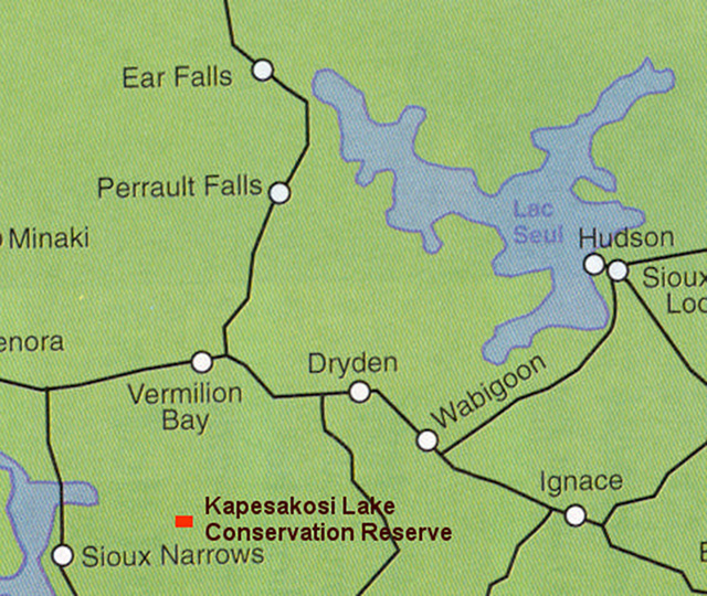
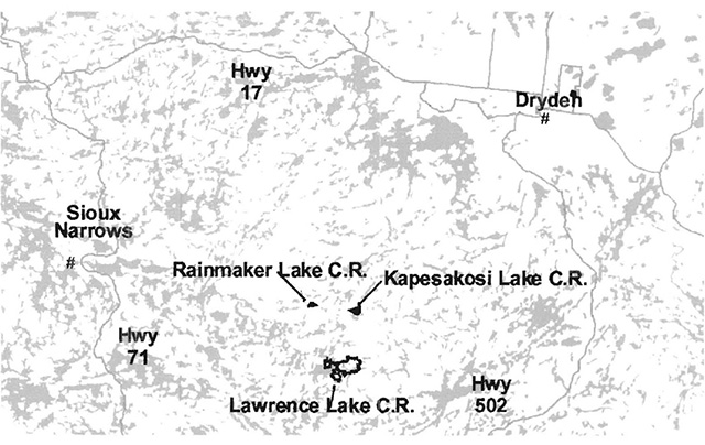
| General Location Description | Located approximately 75 km southwest of the City of Dryden, 40 km south of Vermillion Bay between Kapesakosi and Bait Lake. |
| Access | There is no road or water access. The reserve may be accessible during the winter months via snowmobile. |
Figure 1: General location of Kapesakosi Lake Conservation Reserve. For a more detailed map of site location see Appendix A.
Table 1.2: Representation Targets – Summary of earth science, life science, cultural resource values and present or possible recreational opportunities.
| Life Science Representation | Upland Forest: Mixed forest – red/ white pine dominant Mixed forest – black spruce dominant Mixed forest – birch dominant Wetlands: Animal Species: |
|---|---|
| Earth Science Representation | Moderately broken ground moraine underlain with granitic and volcanic rock. Possible link with the greenstone belt. |
| Cultural Value Representation | There have been no documented cultural values for this site. |
| Recreational Opportunities | According to the Recreation Resource Inventory opportunities exist for trapping. |
Table 1.3: Survey Information – Overview of inventories completed, their level of detail and inventories that are needed.
| Survey Level | Life Science | Earth Science | Cultural | Recreational |
|---|---|---|---|---|
| Reconnaissance | checklist, 2001 and Life Science Inventory, 2001 | checklist, 2001 and Earth Science Inventory, 2001 | not required | checklist, 2001 and Recreation Resource and Inventory, 2002 |
| Detailed | not required | not required | not required | not required |
1.0 Values to be protected
This section provides a description of the key natural heritage values on the site, their condition relative to past resource and management activities, and their sensitivity to future land use and management activities.
Table 2.1: Values identified on Kapesakosi Lake Conservation Reserve.
| Life Science | old growth white pine and future old growth red and white pine. Sandcherry; rare in Site District 4S-5 |
|---|---|
| Earth Science | none of the earth science values were deemed significant |
| Cultural | none determined |
| Aboriginal | none determined |
| Tourism | N/A |
| Recreational Fishing | N/A |
| Recreational Hunting | WMU #8 |
| Trapping | DR04N00101 |
| Bear Management Area | DR-08-010 |
| Bait Harvesting | 494932 |
| Commercial Fishing | N/A |
2.2 Values to be protected
The intent of this SCI is to protect the following values by establishing management guidelines for existing and potential uses in this area given the level of past disturbance and the nature of the existing features.
2.2.1 Forest values
Provincially significant old growth red and white pine can be found throughout this site. As well, Sandcherry was observed on an open rocky area. This species is likely to be rare in Site District 4S-5.
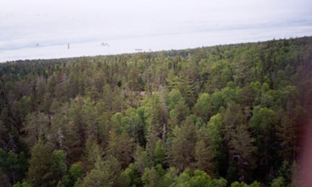
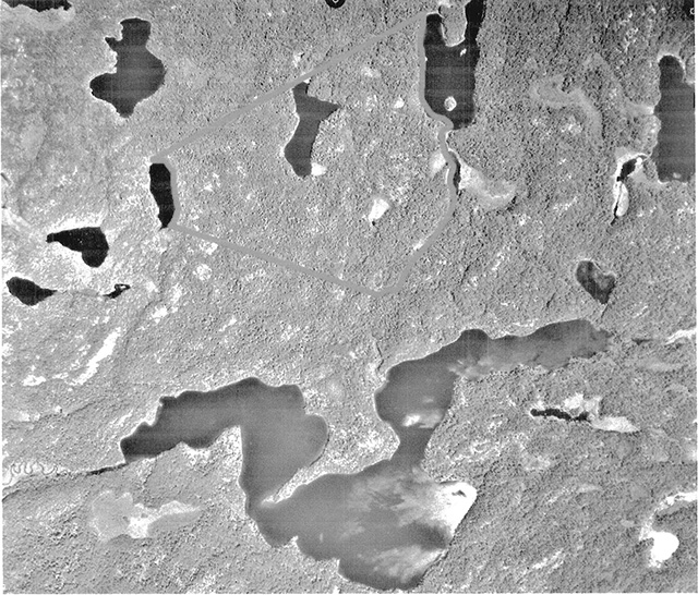
Figure 2: Aerial view of old growth red and white pine mixed forest.
None of the significant forest values found require additional protection other than that already provided by this Statement of Conservation Interest (See Section 3.0 Management Guidelines) and the Kapesakosi Lake Conservation Reserve Policy Report (See Appendix G).
2.2.2 Biological values
No species of herbaceous plant or animal found on the reserve were deemed significant.
2.2.3 Landform values
This reserve contains no significant landform types.
2.2.4 Recreational values
The Recreation Resource Inventory found the forest and wetland vegetation, exposed bedrock, a small lake, terrestrial/aquatic wildlife and volcanic landforms all to be of recreational value. Due to limited access, however, it suggests trapping to be the only recreational activity. It was indicated that none of the recreation features would be sensitive to any recreational use.
2.2.5 Tourism values
While there are no tourism values located on the reserve itself, a commercial boat cache exists on Bait Lake approximately 800 m from the reserve.
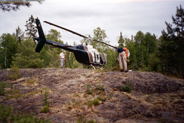
Figure 3: Rocky outcrop found within the reserve.
3.0 Management guidelines
3.1 Land tenure
The Kapesakosi Lake Conservation Reserve consists entirely of Crown land within the unorganized region of the Wabigoon Forest. This reserve is also completely surrounded by Crown land.
The Conservation Reserve will remain Crown land and no dispositions (including Land Use Permits or Licenses of Occupation) will be issued for the site.
The disposition of adjacent Crown Land will be dealt with on a case-by-case basis.
Unauthorized occupations of lands within the Conservation Reserve will be handled in accordance with approved policy, and any required structural removal will be at the owner’s expense.
3.2 Existing and proposed development
There are no roads leading to or within this reserve. At present, there are no existing trails either, however the Recreation Resource Inventory implies the potential for snowmobiling indicating possible winter trails. Some large-diameter stumps were seen, indicating previous harvesting of red and/or white pine probably during the early 1900s. There has been minimal logging in forests adjacent to the reserve.
Facility infrastructure and development for recreational and/or educational purposes may be considered in the future if there is a demonstrated demand for such facilities. All provincial policies that guide development on Crown Lands are applicable in Conservation Reserves. A more detailed management plan would be required prior to any development occurring. The management plan would be required to ensure that there would be no negative impacts to any habitat or ecosystem pertinent to the values protected by the reserve. In particular, the old growth white pine found within this reserve.
3.3 Recreational activities
Most recreational activities that have traditionally been enjoyed in this area can continue provided they pose no threat to the natural ecosystems and features protected by the Conservation Reserve. Those uses that are regulated include hunting, fishing and trapping. Most other permitted activities are non-regulated (i.e. canoeing, exploring, hiking). See Section 2.2.4 for the recreational uses for this Conservation Reserve as determined by the Recreation Resource Inventory.
Mechanical travel is permitted only on the existing roads and trails. Off trail mechanized travel is permitted for retrieval of game only.
3.4 Commercial activities
No new activities, such as commercial logging, hydroelectric power development, new transmission lines (e.g. power or communications), pipelines, highways or roads, and the extraction of aggregate or peat, will be permitted.
An examination of the possible impact of activities on adjacent lands should be evaluated in the Forest Management Plan. Especially due to the small size of the reserve, which increases its susceptibility to edge effects and results in lack of core area necessary for area-sensitive species.
3.5 Aboriginal interests
Aboriginal consultation is ongoing. At present, no issues have been voiced concerning this reserve. Nothing in this Statement of Conservation Interest affects in any way existing or future Aboriginal or treaty rights.
3.6 Natural Resources Stewardship
Natural Resource Stewardship involves the consideration of the following specific natural resource management categories.
3.6.1 Vegetation management
Management within the conservation reserve will allow for the continuation of natural ecosystem processes and functions with minimal human interference.
The forest in the entire area is to be protected from any human alteration. Forest fire protection will be carried out on the Conservation Reserve as on surrounding public lands, with a "light on the land" approach (i.e. no bulldozers, no camp construction, minimal cutting). However, prescribed burns, especially in the understory, to reestablish red and white pine were recommended for future management of the site (Life Science Inventory, 2001).
Forest insect and disease management will continue as on surrounding Crown lands.
3.6.2 Fish and Wildlife Management
Existing Wildlife Management Unit and sport fishing regulations and management activities will apply.
3.6.3 Landforms
None of the landforms mentioned will be altered by landform modification activities such as filling and extraction (see Table 1.2 under Earth Science Representation). The extraction of aggregates and similar materials are not permitted.
Careful mineral exploration may occur in specific new conservation reserves proposed through Ontario’s Living Legacy, in areas that have provincially significant mineral potential. If a portion of the new Conservation Reserve is to be developed for a mine, it would be removed from the reserve, and appropriate replacement lands would be placed in regulations.
3.7 Cultural Resources Stewardship
To fully manage and protect sites, field surveys are required. To date, there have been no surveys done to assess cultural or heritage values. However, common knowledge of the area suggests there to be no such values on this site, thus Cultural Inventories were deemed unnecessary.
3.8 Client services
Given the focus on low key management, client information will be given on an inquiry basis only and will deal with the basic level of information with respect to access, natural heritage appreciation, recommended activities and boundaries.
3.9 Research
Non-destructive research by qualified individuals will be encouraged to provide a better understanding of the natural values protected by the Conservation Reserve and to advance protection, planning and management. In order to assist with enhancing the management guidelines for the reserve, the collection of additional earth and life science information during research is encouraged.
All research programs will require the approval of the Ministry of Natural Resources as will the removal of any natural or cultural specimen. The establishment of permanent plots, observation points or facilities must also be approved and be compatible with the Conservation Reserve protection objective. Any site disturbed by research activities must be rehabilitated as closely as possible to its previous state.
3.10 Marketing
Awareness of the Conservation Reserve is promoted through the Living Legacy web site. Intensive management activity to increase use is not required at this time.
4.0 Implementation
Implementation of this Statement of Conservation Interest will primarily involve monitoring activities to ensure adherence to the management guidelines and responding to inquiries about the site.
Implementation of this statement and management of the reserve are the responsibility of the Wabigoon Forest Area Supervisor. Partnerships may be pursued to address management needs.
5.0 Review and revisions
This Conservation Reserve Statement of Conservation Interest will be reviewed on an ongoing basis.
If changes in management direction are needed at any time, the significance of the changes will be evaluated and further consultation a possibility. Any major amendments will require full public consultation and the approval of the District Manager and Regional Director. Affected clients will be immediately informed of proposed changes to this Statement of Conservation Interest.
This Statement of Conservation Interest complies with all requirements of the Environmental Assessment Act and the Environmental Bill of Rights.
5.2 Public consultation
5.2.1 Results of past consultations
Consultation for the Kapesakosi Lake Conservation Reserve was conducted as part of the consultation on the Ontario’s Living Legacy Land Use Strategy, July 1999. Subsequent consultation took place in June of 2001 to identify any stakeholder issues with the proposed Conservation Reserve.
District Manager letters were sent to the Dryden Forest Management Co., Weyerhaeuser and Ontario’s Forest Industries Association. An additional 87 stakeholder letters were sent out to tourist operators, advisory committees, trappers, land owners and members of the public. As well, newspaper ads were placed in the Ignace Driftwood, June 20 and in the Dryden Observer, June 19 of 2001. Two visits were made to the Dryden District Office. Significant issues stressed concerned permitted uses. As a result of the consultation process concerns were addressed and no analysis was needed.
First Nations Consultation letters were sent to ten Native communities including Wabigoon Lake Ojibway Nation, Aboriginal People of Wabigoon and Eagle Lake First Nation. No issues have been voiced to date. Direct consultation with Treaty 3 First Nations is being carried out on a regional basis.
5.2.2 Present and future consultation
More widespread consultation is not deemed necessary at this time.
5.2.3 Author
This Statement of Conservation Interest was prepared by Alicia H.L. Morin, OLL Intern, Information Management, Dryden District. Assistance was provided by Martin Pell, of the Dryden District and Jim Cameron, of the Thunder Bay Regional office.
6.0 References
Northern Bioscience. Earth Science Inventory for Kapesakosi Lake Conservation Reserve. 2001.
Northern Bioscience. Life Science Inventory for Kapesakosi Lake Conservation Reserve. 2001.
Ontario Ministry of Natural Resources. Kapesakosi Lake Conservation Reserve (C2346) Fact Sheet. June 2001.
Ontario Ministry of Natural Resources. Kapesakosi Lake Conservation Reserve (C2346) Recreation Resource Inventory Report. 2002.
Ontario Ministry of Natural Resources. Ontario’s Living Legacy Land Use Strategy. July, 1999. p. 24. Queen’s Printer for Ontario.
Ontario Ministry of Natural Resources, Lands & Natural Heritage, Lands & Waters. Conservation Reserve Policy and Procedure PL 3.03.05. February, 1997. 22 pp.
Appendix A: Map of Kapesakosi Lake Conservation Reserve
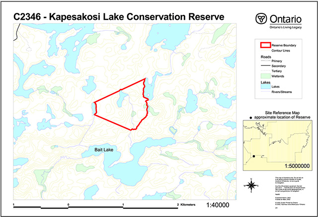
Appendix B: Aerial photograph of Kapesakosi Lake Conservation Reserve
Appendix C: Forest resource inventory (FRI) map for Kapesakosi Lake Conservation Reserve
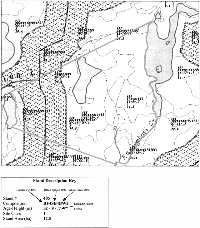
Enlarge Appendix C forest resource inventory map
Appendix D: Earth science reconnaissance inventory
Detailed information for site C2341 Kapesakosi Lake Conservation Reserve
Protection history
This reserve was identified under the provincial Lands for Life - Ontario’s Living Legacy program. It was principally identified for its life science representation with no previous
Setting
Kapesakosi Lake Conservation Reserve incorporates lands south of Kapesakosi Lake and north of Bait Lake, adjacent to Kapesakosi Creek, which delineates the eastern boundary of the reserve. It comprises 178 hectares of Crown land located in Dryden MNR District. Elevations range from 380 to 450 m a.s.l. It appears to have undergone no previous disturbance.
Earth science features
Bedrock geology
Kapesakosi Lake Conservation Reserve lies wholly within the Archean age Wabigoon subprovince, at the southern edge of the Atikwa batholith. Rock outcrop density is very high, on the order of 90%, beneath a pervasive tree canopy. No systematic geological surveys have covered the Reserve. Existing compilation mapping (Blackburn et al 1981) suggest the area of the Reserve to be entirely underlain by granitic rocks. The present site visit (comprising 3 stations at two helicopter landings in the western half of the Reserve, and aerial reconnaissance) suggests that mafic metavolcanic rocks underlie half of the Reserve. Mafic metavolcanic rocks were observed at all 3 stations. These included rocks that displayed pillow structure, definitive of mafic submarine volcanism, at station 3 (photo 1). Interlayering of granitic rock with amphibolitic mafic rocks was observed at station 1 (photo2). During the aerial reconnaissance, pink to grey granitic rocks were observed in the eastern half of the Reserve. A prominent ridge to the southwest of the Reserve was observed to be entirely comprised of dark green mafic rocks. This observation suggests a linkage with a greenstone belt sliver passing through Bait Lake, previously interpreted between the Atikwa batholith to the north and the Lawrence Lake batholith to the south (Blackburn et al 1981).
Surficial geology
Bedrock dominates in most of the Reserve (Roed 1980; Minning and Sharpe 1991) but a thin veneer of till ground moraine covers bedrock in places, particularly in the extreme west portion. Minning and Sharpe (1991) have interpreted gravel outwash deposits in the south comer, and minor organic deposits in places, particularly along the creek that defines the eastern edge of the Reserve.
Significance
None of the earth science features identified in the reserve are of significance.
Sensitivity
None of the earth science features identified is sensitive to either natural or cultural impacts.
Recommendations
No recommendations are made.
References
Blackburn, C.E, Beard, R.C. and Rivett, S. 1981. Kenora-Fort Frances, Districts of Kenora and Rainy River, Geological Compilation Series; Ontario Geological Survey, Map 2443, scale 1:253 440.
Minning, G.V. and Sharpe, D.R. 1991. Surficial geology, Rowan Lake, Ontario; Geological Survey of Canada, Map 1773A scale 1:100 000.
Roed, M.A. 1980. Northern Ontario Engineering Geology Terrain Study, Data Base Map, Rowan Lake; Ontario Geological Survey, Map 5060, scale 1:100 000.
Photographs
- Well-defined pillow structure in mafic metavolcanic rocks. Darker pillow rims contain yellow-weathering epidote. (Stn. 3; UTM 0476776E 5470298N)
- Inter layering of pink granitic rock and dark green amphibolite. (Stn. 1; UTM 0477403E 5470861N)
Glossary of geological terms for site C2341 Kapesakosi Lake Conservation Reserve
Archean: The earliest eon of Precambrian time, older than 2500 million years.
Amphibolite: Volcanic rock that has been metamorphosed to high grade, in which the mineral homeblende (an amphibole) is developed.
Batholith garnet: A very large body of igneous intrusive rock.
Garnet: A complex silicate mineral of metamorphic origin that is used to indicate grade of metamorphism (temperature and pressure conditions).
Granitic: General term applied to intrusive igneous rocks with visibly distinct crystallinity, that are quartz-bearing: includes granite, granodiorite, tonalite and quartz diorite.
Greenstone belt: General term for all the rocks within a predominantly volcanic sequence of rocks, but including sedimentary and igneous intrusive rocks, that commonly has a linear form.
Mafic: Refers to igneous rocks with a high content of magnesium-rich minerals, commonly imparting a dark colour to the rock.
Meta (prefix): Implies metamorphism of the rock type to which it is applied, e.g. metasedimentary.
Moraine: Sediment deposited by direct glacial action.
Outwash: Stratified sediment deposited by meltwater streams beyond glacier ice.
Pillows: Multiple, stacked structures that resemble pillows in shape and size, found in mafic volcanic flows, that indicate extrusion of lava beneath water.
Subprovince: Structural subdivision of a geologic province, commonly but not uniquely fault-bounded, based on distinctive internal rock types, structures, ages and metamorphic conditions.
Till: Non sorted, non stratified sediment carried or deposited by a glacier.
Appendix E: Life science reconnaissance inventory C2341 Kapesakosi Lake C.R.
Natural Heritage Area - Life Science Checksheet
| Name | C2341 Kapesakosi Lake |
|---|---|
| Map name | Lawrence Lake |
| Map number | 52/F6 |
| UTM Ref. | Zone 15 477000 E 5470000 N |
| District | Kenora |
| Latitude / longitude | 49°23'20° N / 93° 19° W |
| NAD | 83 |
| Min. Alt. | 380 m |
| Max. Alt. | 450 m |
| Locality | Approximately 85 km N of Fort Frances |
| Township | unorganized |
| Area | 178 ha. |
| Ownership | Crown |
| MNR region | Northwest region |
| Ecoregion and ecodistrict | 4S-5 |
| Landform unit | See Table 3 |
| MNR District | Dryden |
| Aerial photographs | Year-Roll-Flight Line-Numbers 97-4913-B 47-216 |
Physical and biological features
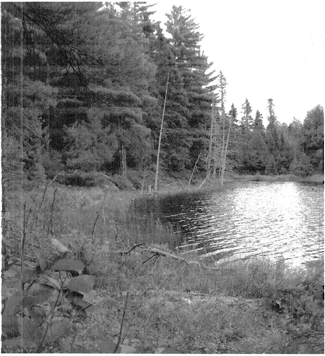
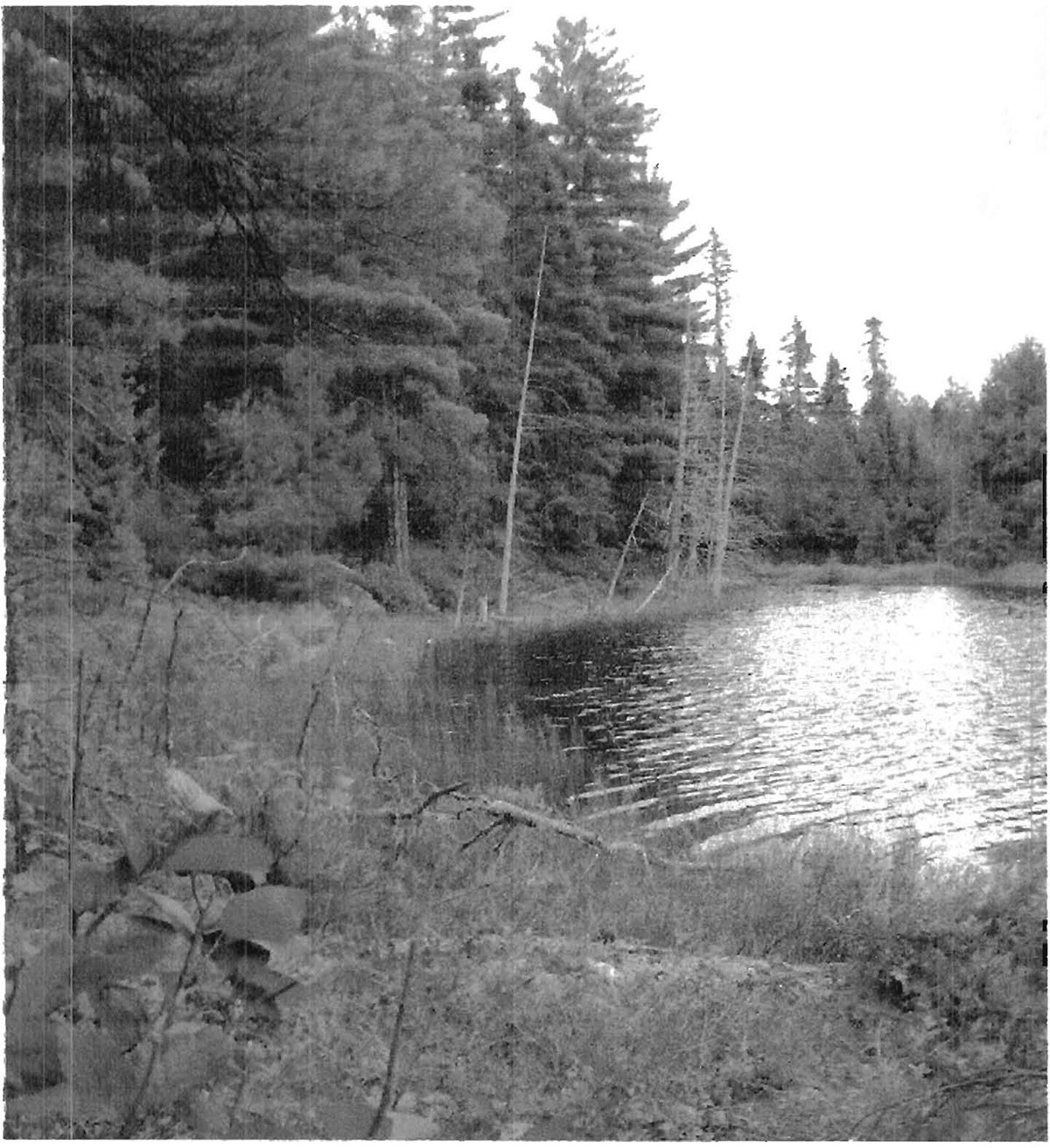
Kapesakosi Lake Conservation Reserve is located approximately 1 km south of Kapesakosi Lake in Site District 4S-5. Two small, unnamed lakes bound the conservation reserve on the east and west. Another small lake (8.5 ha) falls entirely within the reserve boundary (photo 1) and drains to the south into Bait Lake via a small stream. Moderately broken ground moraine is the predominant landform in the reserve. The till is of variable depth but is generally shallow, and scattered bedrock outcrops (< 1 ha) occur throughout much of the reserve. There are also small pockets of organic terrain along lakeshores and riparian areas.
Mixedwoods and conifer forest cover the majority of the reserve. Red and white pine mixedwood (ES24) are found throughout much of the reserve on clay loam soils (photo 2). Balsam fir, white spruce, black spruce, white birch, and trembling aspen are subdominant in the canopy. One large (27 ha) white pine stand (Stand #486, BM 494932)) in the central portion of the reserve is old growth (160 year age-class) (Figure 1). Most of the remaining red and white pine mixedwood is typed as approximately 80 years of age. Beaked hazel, bush honeysuckle, blueberries, and bunchberry typically dominate the understory.
A dense stand of red and white pines (ES1S, V26, V27) is located in the northern portion of the reserve on the southwest-facing slope along the lakeshore (photo 3). Soils are sandy clay loam, and are slightly coarser and better drained than in the much of the pine mixedwood. Two 43-47 cm DBH red pine aged during field reconnaissance were 78-88 years, and a 40-cm DBH white pine was 78 years old. Conifer litter and Schreber’s moss blanket the forest floor, with only scattered herbs such as Canada mayflower and prince’s pine.
Birch-dominated mixedwoods predominate on thin silty clay loam tills over bedrock the western portion of the reserve. Black spruce, balsam fir, trembling aspen, and white pine are minor components of the canopy and occasional tree-sized (>20 cm DBH, >10 m tall) red maple are also present. A dense shrub understory of balsam fir, beaked hazel, and blueberries is present, particularly in gaps caused by blowdown. Although the stand is listed as 50 years old in the FRI, much of this stand is mature to overmature with large diameter (e.g. 30 cm DBH) birch present. Black spruce dominated mixedwoods (ES27) are also found in the eastern portion of the reserve near the stream and lakeshore.
Small pockets of poor fen (ES 41, W21) adjacent to riparian areas are dominated by leatherleaf, bog laurel, few-seeded sedge, and Sphagnum. Stunted tamarack, black spruce, and white pine are rooted in drier hummocks.
Small rock outcrops (too small to individually map) typically had sand cherry, rock spike-moss, pale corydalis, bearberry, and other xeric species.
Representation
Rainmaker Lake was one of six old growth stands selected to represent old-growth pine in 4S-5 based on the Northwest Region Old Growth Study (Simpson 1994). Other, younger-aged red and white pine mixedwood stands within conservation reserve will provide future old growth as the existing old growth stand senesces. These conifer-dominated mixedwoods on weakly broken ground moraine and the deciduous-dominated mixedwoods and conifer forests found in the reserve are representative for the Site District (Table 3).
Condition
A few large-diameter stumps were observed, indicating there was some previous harvesting of red and/ or white pine, likely during the early 1900s (photo 4). There is no road access to the conservation reserve, suggesting past logging was done during the winter or using waterways.
There is one trapline in the conservation reserve. The nearest commercial activity is a commercial boat cache on Bait Lake, 800 m to the south of the reserve.
Diversity
Kapesakosi Lake Conservation Reserve has relatively low diversity due to its small size and only one main landform type. However, the loamy soil is relatively rich and there is wide range of microhabitats, from wetland to xeric outcrop. Mixedwoods are typically the most diverse forests in northwestern Ontario, and at least nine tree species are present in the reserve. There is a fairly rich shrub and herb understory in the mixedwoods of the reserve.
Ecological considerations
No fires since the 1920s have been mapped in Kapesakosi Lake, but occasional red and white pine trees showed evidence of fire-scarring due to lightning strike. A few small « 2 m tall) white pine, (but no red pine regeneration), were observed in the mixedwood. Red pine, in particular, requires exposed mineral soil and full sunlight for successful germination and growth. White pine is more tolerant of shading, and often exists in a mixedwood condition on loamy soils. Over the long term however, the red and white pine component in the reserve may decrease in the absence of fire. Moderate spruce budworm mortality of the balsam fir and white spruce component in the conservation reserve occurred during the late 1980s. Standing dead balsam fir and blowdown were noted during field reconnaissance. Blowdown of large diameter pine and birch was observed during field reconnaissance. Disease and/or senescence were likely a contributing factor, since no large scale windthrow events have been recorded for the reserve. Abundant balsam fir and beaked hazel are found in gaps created by blowdown, as is some white pine regeneration.
Extensive forest tent caterpillar defoliation of trembling aspen, blueberries, and even white birch was observed in the reserve.
Moose pellets and browsed shrubs (beaked hazel, dogwood, trembling aspen) were evident, particularly in the birch mixedwood. The small size of the conservation reserve makes it sensitive to edge effects and there is a lack of core area for area-sensitive species. Fortunately, there has been little logging in forests adjacent to the reserve.
Special features
The 26 ha white pine stand (FRI Stand #422, BM494932) in the central portion of the reserve was identified as old growth forest in Simpson (1996). FRI typing indicate the stand is at least 160 years old.. Adjacent, younger, red and white pine stands in the reserve provide a potential futun:³ source of old growth red and white pine.
Sandcherry was found on a rocky open area (ES12) in the conservation reserve. This species is limited to xeric habitats such as beaches, dunes, and rock outcrops, and is likely rare in Site District 4S-S.
Recommendations
Prescribed fire, especially understory bums, should be considered as a future management option to maintain and enhance the red and white pine component within the reserve. Since the reserve is in the intensive fire management zone, prescribed fire could be a mechanism for allowing this natural process to occur without threatening other significant values.
Significance level and summary of major representative values
The conservation reserve includes provincially significant old growth white pine forests. Although within the "core" portion of white pine range, this stand is significant and representative for its old growth characteristics.
Major information sources
Harris, A.G., S.C. McMurray, P.W.C. Uhlig, J.K. Jeglum, R.F. Foster and G.D. Racey. 1996. Field guide to the wetland ecosystem classification for northwestern Ontario. Ont. Min. Natur. Resour. , Northwest Sci.&Technol. Thunder Bay, Ont. Field Guide FG-01. 74 pp. + Append.
Noble, T. 1995. Site Region 3S Gap Analysis. Unpublished report for Ontario Parks, Ont. Min. Natur. Resour. Thunder Bay, Ont. 28 p. + appendices.
OMNR. 1999. Ontario’s Living Legacy - Land Use Strategy. Queen’s Printer, Toronto.
Racey, G.D., A.G. Harris, J.K. Jeglum, R.F. Foster and G.M. Wickware. 1996. Terrestrial and wetland ecosites of northwestern Ontario. Ont. Min. Natur. Resour. , Northwest Sci. & Technol. Thunder Bay, Ont. Field Guide FG-02. 88 pp. + Append.
Sims, R.A., W.D. Towill, K.A. Baldwin, P. Uhlig and G.M. Wickware. 1997. Field guide to the forested ecosystem classification for northwestern Ontario. Ont. Min. Natur. Resour. , Northwest Sci. & Technol. Thunder Bay, Ont. Field Guide FG-03. 176 p.
Simpson, E. 1996. Old growth red and white pine forests: Northwest Region report on protection. NWST Tech. Rep. TR-98
Date Compiled: 18/07/02
Compilers: Robert Foster, Allan Hams. Northern Bioscience
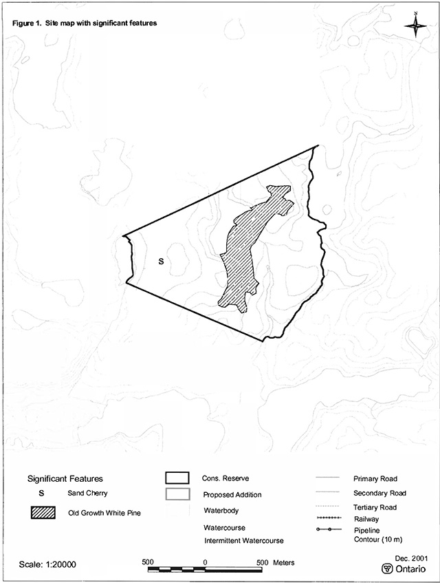
Figure 1. Site map with significant features
Photo 1. Shoreline of small unnamed lake within reserve.
Photo 2. Red and white pine mixedwood includes significant old growth stand.
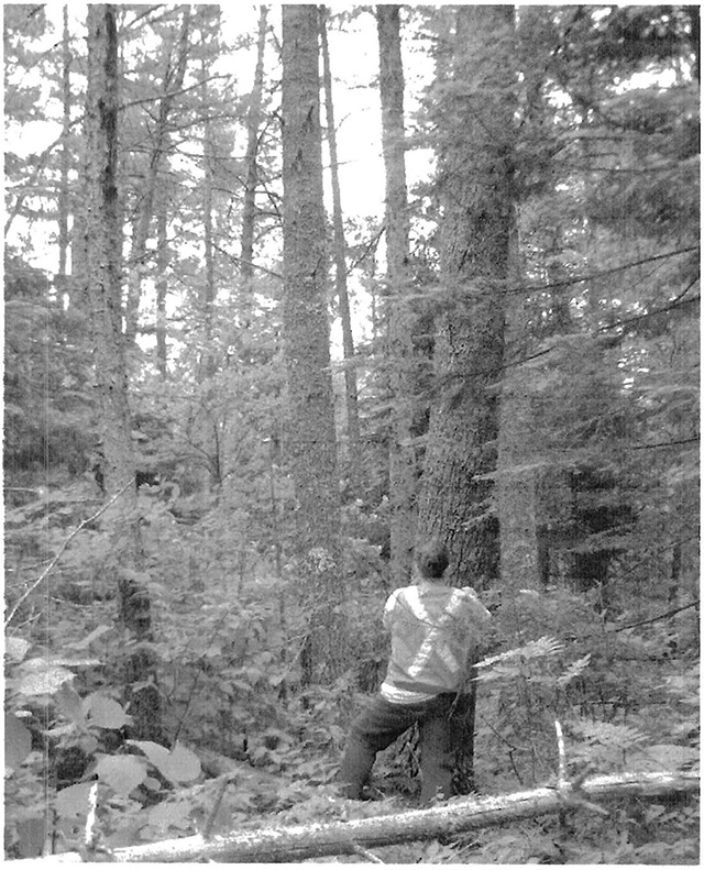
Photo 3. Red and white pine stand (ES 15) on sandy clay loam soils in northern part of reserve.
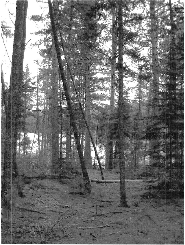
Photo 4. Stumps with lightning scars provide evidence of previous harvesting and wildfire.
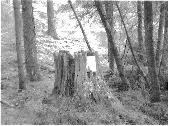
Table 1. Land cover classes of Kapesakosi Lake (derived from Landsat data)
| Landcover Class | Area (ha) | % of site |
|---|---|---|
| Water | 13 | 7 |
| Treed Fen | 1 | 1 |
| Treed Bog | <1 | <1 |
| Dense Deciduous Forest | 47 | 26 |
| Dense Coniferous Forest | 2 | 1 |
| Mixed Forest - mainly Deciduous | 25 | 14 |
| Mixed Forest - mainly Coniferous | 76 | 42 |
| Sparse Coniferous Forest | 15 | 8 |
| Total | 179 | 100 |
Table 2. Rapid assessment plot summary from Kapesakosi Lake
| Plot No. | V/W Type | ES Type | Date |
|---|---|---|---|
| 242 | V27 | ES15 | 07/12/2001 |
| 243 | V26 | ES24 | 07/12/2001 |
| 244 | V4 | ES29 | 07/12/2001 |
| 245 | W21 | ES41 | 07/12/2001 |
Table 3. Landform – vegetation (LV) type representation for Kapesakosi Lake (ha)
| Site District | Landform | Surface expression | Conifer | Conifer mixed | Deciduous | Deciduous mixed | Open wetland | Sparse forest | Grand total |
|---|---|---|---|---|---|---|---|---|---|
| 4S-5 | Ground Moraine | Moderately broken | 3 |
73 | 49 | 25 | 2 | 17 | 169 |
| Grand total | 3 | 73 | 49 | 25 | 2 | 17 | 169 |
C = critical to meet representation targets at the Site District level
R = contributes to representation of the LV type at the Site District level
Table 4. Site type matrix for Kapesakosi Lake
| Temperature | Type | Arid | Very dry | Dry | Dry Mesic | Mesic | Wet Mesic | Wet | Very wet | Saturated | Open water |
|---|---|---|---|---|---|---|---|---|---|---|---|
| Colder | Rock | ||||||||||
| Colder | Sand | ||||||||||
| Colder | Loam | ES29 | |||||||||
| Colder | Clay | ES29 | |||||||||
| Colder | Organic | 41 | |||||||||
| Normal | Rock | ||||||||||
| Normal | Sand | ||||||||||
| Normal | Loam | ES27 | ES29 | ||||||||
| Normal | Clay | ES27 | ES29 | ||||||||
| Normal | Organic | ||||||||||
| Warmer | Rock | ES7 | ES7 | ||||||||
| Warmer | Sand | ES15 | ES15 | ES24 | |||||||
| Warmer | Loam | ES24 | |||||||||
| Warmer | Clay | ||||||||||
| Warmer | Organic |
Kapesakosi Lake (C2341) plant species lists
Based on fieldwork conducted on July 12, 2001 and data provided by OMNR. Taxonomic order and species names generally follow Morton and Venn (1990). Introduced species are marked "I". Provincially rare species (Oldham 1999) are marked "P". Regionally rare species (TBFN 1998) are marked "R" . Voucher specimens were collected for species marked "*".
| Family Equisetaceae | Horsetail Family |
|---|---|
| Equisetum sylvaticum L. | Woodland Horsetail |
| Family Dennstaetiaceae | Bracken Family |
|---|---|
| Pteridium aquilinum (L.) Kuhn | Bracken |
| Family Osmundaceae | Flowering Fern Family |
|---|---|
| Osmunda claytoniana L. | Interrupted Fern |
| Family Polypodiaceae | Polypody Family |
|---|---|
| Polypodium virginianum L. | Rock Polypody |
| Family Lycopodiaceae | Clubmoss Family |
|---|---|
| Lycopodium annotinum L. | Bristly Clubmoss |
| Lycopodium obscurum L. | Flat-branched Tree Clubmoss |
| Family Selaginellaceae | Spikemoss Family |
|---|---|
| Selaginella rupestris (L.) Spring | Rock Spikemoss |
| Family Cupressaceae | Juniper Family |
|---|---|
| Thuja occidentalis L. | Eastern White Cedar |
| Family Pinaceae | Pine Family |
|---|---|
| Larix laricina (duroi) k. koch | Tamarack |
| Picea mariana (Miller) BSP | Black Spruce |
| Pinus resinosa Sol. ex Aiton | Red Pine |
| Pinus strobus L. | White Pine |
| Family Cyperaceae | Sedge Family |
|---|---|
| Carex aquatilis Wahlenb. | Water Sedge |
| Carex bebbii (L. Bailey) Olney ex Fern. | Bebb’s Sedge |
| Carex brunnescens (Pers.) Poiret ex Lam. | Brownish Sedge |
| Carex lacustris Wild. | Lake Sedge |
| Carex lasiocarpa Ehrh. | Wire Sedge |
| Carex limosa L. | Mud Sedge |
| Carex oligosperma Michaux | Few-seeded Sedge |
| Dense Cottongrass |
| Family Iridaceae | Iris Family |
|---|---|
| Iris versicolor L. | Wild Iris |
| Family Liliaceae | Lily Family |
|---|---|
| Clintonia borealis (Aiton) Rat. | Blue Bead Lily |
| Maianthemum canadense Desf. | Wild Lily-of-the-valley |
| Maianthemum trifolium (L.) Sloboda | Three-leaved Solomon’s Seal |
| Family Scheuchzeriaceae | Pod-grass Family |
|---|---|
| Scheuchzeria palustris L. | Pod-grass |
| Family Typhaceae | Cattail Family |
|---|---|
| Typha latifolia L. | Common Cattail |
| Family Aceraceae | Maple Family |
|---|---|
| Acer rubrum L. | Red Maple |
| Acer spicatum Lam. | Mountain Maple |
| Family Araliaceae | Ginseng Family |
|---|---|
| Aralia nudicaulis L. | Wild Sarsaparilla |
| Family Asteraceae | Sunflower Family |
|---|---|
| Family Aster macrophyllus L. | Large-leaved Aster |
| Solidago uliginosa Nutt. | Marsh Goldenrod |
| Family Balsaminaceae | Touch-me-not Family |
|---|---|
| Impatiens capensis Meerb. | Jewel Weed |
| Family Betulaceae | Birch Family |
|---|---|
| Family Alnus incana (L.) Moench | Speckled |
| Alder Alnus viridis (Chaix) DC. | Green Alder |
| Betula papyrifera Marshall | White Birch |
| Family Caprifoliaceae | Honeysuckle Family |
|---|---|
| Family Diervilla lonicera Miller | Bush Honeysuckle |
| Lonicera canadensis Bartram | Canada Fly Honeysuckle |
| Family Cornaceae | Dogwood Family |
|---|---|
| Cornus canadensis L. | Bunchberry |
| Family Droseraceae | Sundew Family |
|---|---|
| Drosera rotundifolia L. | Round-leaved Sundew |
| Family Ericaceae | Heath Family |
|---|---|
| Chamaedaphne calyculata (L.) Moench | Leatherleaf |
| Gaultheria hispidula (L.) Muhlenb. ex Bigelow | Creeping Snowberry |
| Kalmia polifolia Wangenh. | Bog Laurel |
| Ledum groenlandicum Oeder | Labrador Tea |
| Vaccinium angustifolium Aiton | Low Blueberry |
| Vaccinium myrtilloides Michaux | Velvet-leaved Blueberry |
| Vaccinium oxycoccos L. | Small Cranberry |
| Family Fumariaceae | Fumitory Family |
|---|---|
| Corydalis sempervirens (L.) Pers. | Pale Corydalis |
| Family Guttiferae | St. John’s-wort Family |
|---|---|
| Triadenum fraseri (Spach) Gleason | Marsh St. Johnswort |
| Family Menyanthaceae | Bogbean Family |
|---|---|
| Menyanthes trifoliata L. | Buckbean, Bogbean |
| Family Myricaceae | Bayberry Family |
|---|---|
| Myrica gale L. | Sweet Gale |
| Family Nymphaeaceae | Water-lily Family |
|---|---|
| Nuphar variegata Durand in Clinton | Yellow Pond Lily |
| Family Oleaceae | Olive Family |
|---|---|
| Fraxinus nigra Marshall | Black Ash |
| Family Polygonaceae | Buckwheat Family |
|---|---|
| Polygonum cilinode Michaux | Fringed Bindweed |
| Family Primulaceae | Primrose Family |
|---|---|
| Trientalis borealis Rat. | Starflower |
| Family Pyrolaceae | Wintergreen Family |
|---|---|
| Chimaphila umbellata (L.) Barton | Pipsissewa |
| Family Ranunculaceae | Buttercup Family |
|---|---|
| Coptis trifolia (L.) Salisb. | Three-leaved Gold Thread |
| Family Rosaceae | Rose Family |
|---|---|
| Amelanchier bartramiana (Tausch) M.Roemer | Oblong-fruited Juneberry |
| Potentilla arguta Pursh | Tall Cinquefoil |
| Prunus pensylvanica L.f. | Pincherry |
| Prunus pumila L. | Sandcherry |
| Rosa acicularis Lindley | Prickly Wild Rose |
| Rubus idaeus L. | Common Raspberry |
| Rubus pubescens Raf. | Dwarf Raspberry |
| Sorbus decora (Sarg.) C.Schneider | Showy Mountain Ash |
| Family Sarraceniaceae | Pitcher plant Family |
|---|---|
| Sarracenia purpurea L. | pitcher plant |
Kapesakosi Lake (2341) animal species list
Based on fieldwork conducted on July 12, 2001 and data provided by OMNR. Taxonomic order and nomenclature follow AOU (1998) for birds and Banfield (1974) for mammals. Nesting evidence codes follow the Ontario Breeding Bird Atlas:
Possible nesting:
H - Species observed in breeding season in suitable habitat.
S - Singing male present or breeding calls heard in breeding season in suitable habitat.
Voucher specimens were collected for all odonate species.
Birds
| Loons | Family Gaviidae |
|---|---|
| Common Loon (H) | Gavia immer |
| Wood-warblers | Family Parulidae |
|---|---|
| Tennessee Warbler (S) | Vermivora peregrina |
| Nashviile Warbler (S) | Vermivora ruficapilla |
Amphibians
| Hylidae | Family Hylidae |
|---|---|
| Tetraploid Gray Treefrog | Hyla versicolor |
Mammals
| Squirrels | Family Sciuridae |
|---|---|
| Red Squirrel | Alces alces |
| Deer | Family Cervidae |
|---|---|
| Moose | Alces alces |
Damselflies and Dragonflies
| Bluets | Family Coenagrionidae |
|---|---|
| Boreal Bluet | Enallagma boreale |
| Emeralds | Family Corduliidae |
|---|---|
| American Emerald | Cordulia shurtleffi |
| Skimmers | Family Libellulidae |
|---|---|
| Crimson-ringed Whiteface | Leucoffhinia glacialis |
| Hudsonian Whiteface | Leucorrhinia hudsonica |
Appendix F: Recreation Inventory Checklist for Kapesakosi Lake Conservation Reserve - C2346
| Name | Kapesakosi Lake Conservation Researve - C2341 |
|---|---|
| Map name | Lawrence Lake |
| NTS number | 52/F6 |
| UTM reference | 477016 5470119 |
| OBM number | 20 15 4700 54700 |
| Latitude / longitude | 49°23 / 93°19 |
| Area (ha) | 176.00 (ha) |
| Ownership | Crown |
| MNR region | Northwest |
| MNR district | Dryden |
| Park Zone | Northwest |
| County | N/A |
| Township | N/A |
| Recreation features |
|
| Recreation activities | 1. H06 Trapping |
| Recreation factors | Features | Rating: (Very High, High, Moderate, Low, N/A) |
|---|---|---|
| Most scarce feature: | N/A | |
| Feature scarcity: | N/A | |
| Most unique feature: | N/A | |
| Activity attraction capability: | Low | |
| Scenic attractiveness: | High | |
| Geographic significance | Low | |
| Feature significance | Low | |
| Most sensitive feature to recreation use: | N/A | |
| Feature sensitivity to recreation use: | N/A | |
| Most sensitive feature to resource development: | 1 | |
| Feature sensitivity to resource development | Moderate | |
| Cultural/historic and archaelogical features: | N/A |
Comments: Road to Kapesakosi Lake is drivable, however access into the Conservation Reserve is limited to helicopter, or snowmobile in the winter season.
Date compiled: June 11, 2001
Compiler: Irene Schneider
Source: Recreation Resource Inventory Standards and Proceedures DRAFT REPORT. Gov. of British Columbia. Ministry of Forest Range, Recreation and Forests Practices Branch, March 1995.
Ontario Ministry of Natural Resources, Ontario Parks
300 Water Street, Peterborough, Ontario K9J 8N1
Appendix G: Kapesakosi Lake Conservation Reserve Policy Report
Policy Report (revised October 16, 2001)
Identification:
ID: C2346
Area Name: Kapesakosi Lake
Area (ha): 21
Land Use: Conservation Reserve
Category:
Description:
This site contains a representative old growth red and white pine forest.
Land use intent
The intent is to regulate this area as a Conservation Reserve.
Management of this area is also governed by the general policies contained in the Land Use Strategy (1999).
Management direction:
Those uses and management activities not listed in the following table are governed by existing Conservation Reserve policy. Over time the management direction will be elaborated in a Statement of Conservation Interest or Resource Management Plan. Any new uses, and commercial activities associated with them, will be considered on a case by case basis, and they must pass a test of compatibility to be acceptable. Compatibility is normally determined through a planning process.
Commercial activities
| Activity | Permitted | Guidelines |
|---|---|---|
| Aggregate extraction | No | |
| Bait fishing - existing: | Yes | Existing use permitted to continue, unless there are significant demonstrated conflicts. |
| Bait fishing - new: | Maybe | New operations can be considered, subject to the "test of compatibility". |
| Commercial fishing - existing: | Yes | Existing use permitted to continue, unless there are significant demonstrated conflicts. |
| Commercial fishing - new: | Maybe | New operations can be considered, subject to the "test of compatibility". |
| Commercial fur harvesting - existing: | Yes | Existing use permitted to continue, unless there are significant demonstrated conflicts. Existing trap cabins can continue; new cabins are not permitted. |
| Commercial fur harvesting - new: | Maybe | New operations can be considered, subject to the "test of compatibility". |
| Commercial hydro development | No | |
| Commercial timber harvest | No | |
| Commercial tourism - existing: | Yes | Existing authorized facilities can continue, unless there are significant demonstrated conflicts. |
| Commercial tourism - new: | Maybe | New tourism facilities can be considered during the planning for an individual reserve. |
| Bear hunting by non residents (guided) - existing: | Yes | Existing authorized operations permitted to continue. |
| Bear hunting by non residents (guided) - new: | Maybe | New operations not permitted. |
| Outfitting services - existing: | Yes | Existing authorized operations permitted to continue. |
| Outfitting services - new: | Maybe | New operations can be considered during the planning for an individual reserve. |
| Outpost camps - existing: | Yes | Existing authorized facilities permitted to continue. |
| Outpost camps - new: | Maybe | New facilities can be considered during the planning for an individual reserve. |
| Resorts/lodges - existing: | Yes | Existing authorized facilities permitted to continue. |
| Resorts/lodges - new: | Maybe | New facilities can be considered during the planning for an individual reserve. |
| Energy transmission and communications corridors - existing: | Yes | These facilities should avoid conservation reserve lands wherever possible. |
| Energy transmission and communications corridors - new: | No | |
| Food harvesting (commercial) - existing: | Maybe | |
| Food harvesting (commercial) - new: | Maybe | |
| Mineral exploration and development | Maybe | Mineral exploration may occur under controlled conditions in portions of new conservation reserves that are identified through further analysis and consultation as having provincially-significant mineral potential. If a site is to be developed for a mine, it would be deregulated as part of the reserve, and a replacement area added to the reserve. |
| Peat extraction | No | |
| Wild rice harvesting - existing: | Yes | |
| Wild rice harvesting - new: | Maybe |
Land and resource management activities
| Activity | Permitted | Guidelines |
|---|---|---|
| Crown land disposition Private use: | Maybe | |
| Crown land disposition Commercial use | Maybe | Sale of lands is not permitted, except for minor dispositions in support of existing uses (e.g. reconstruction of a septic system). Renewals of existing leases and land use permits are permitted. Requests for transfer of tenure will be considered in the context of the Statement of Conservation Interest or Resource Management Plan. New leases or land use permits permitted for approved activities. Tourism facilities can apply to upgrade tenure from LUP to lease. |
| Fire suppression | Yes | Fire suppression policies are similar to adjacent Crown lands, unless alternative fire policies have been developed through a planning process. |
| Fish habitat management | Maybe | |
| Insect/disease suppression | Maybe | |
| Inventory/monitoring | Yes | |
| Personal use permits for wood harvesting | Maybe | |
| Prescribed burning | Maybe | |
| Roads (resource access) - existing: | Yes | Existing roads can continue to be used. Continued use will include maintenance and may include future upgrading. |
| Roads (resource access) - new: | Maybe | New roads for resource extraction will not be permitted, with the exception of necessary access to existing forest reserves for mineral exploration and development, or where part of a conservation reserve has been formally identified as having provincially significant mineral potential that is open for controlled exploration. |
| Vegetation management | Maybe | Conservation Reserves policy indicates that Featured Species Management and Natural Systems Management may be permitted. Vegetation management can be considered in a planning process. |
| Wildlife population management | Maybe |
Science, education and heritage appreciation
| Activity | Permitted | Guidelines |
|---|---|---|
| Collecting | No | |
| Historical appreciation | Yes | |
| Nature appreciation | Yes | |
| Photography and painting | Yes | |
| Research | Yes | |
| Wildlife viewing | Yes |
Recreation activities and facilities
| Activity | Permitted | Guidelines |
|---|---|---|
| All-terrain vehicle use On trails | Yes | Existing use permitted to continue where it does not adversely affect the values being protected. |
| All-terrain vehicle use Off trails | No | ATV use off trails is not permitted except for direct retrieval of game. |
| Campgrounds | Maybe | |
| Food gathering | Yes | |
| Horseback riding(trail) | Yes | Existing use on trails permitted. |
| Hunting | Yes | |
| Mountain bike use | Yes | Existing use on trails permitted. |
| Motor boat use (commercial) | Yes | |
| Motor boat use (private) | Yes | |
| Non-motorized recreation travel | Yes | |
| Private recreation camps (hunt camps) - existing | Yes | Existing camps permitted to continue, and may be eligible for enhanced tenure, but not purchase of land. |
| Private recreation camps (hunt camps) - new | No | |
| Rock climbing | Maybe | |
| Snowmobiling (On Trails) | Yes | Existing use permitted to continue where it does not adversely affect the values being protected. |
| Snowmobiling (Off Trails) | Maybe | Snowmobile use off trails is not permitted, except that snowmobiles may be used for direct retrieval of game. |
| Sport fishing: | Yes | |
| Trail development | Maybe | Development of trails for a variety of activities (e.g. hiking, cross-country skiing, cycling, horseback riding, snowmobiling) can be considered as part of planning for an Individual reserve. |
Note: The policies outlined in this table do not supersede any Aboriginal or treaty rights that may exist, or other legal obligations.
Source: OLL Land Use Strategy, Table 4, and Conservation Reserves Policy.
Management of this conservation reserve is carried out within the context of Conservation Reserve policy as amended by the policies for new conservation reserves outlined in the Ontario’s Living Legacy Land Use Strategy.
Source of direction:
Ontario’s Living Legacy Land Use Strategy
Explanation of edits:
N/A
Footnotes
- footnote[R] Back to paragraph contributes to representation of the LV type at the Site District level
- footnote[*] Back to paragraph Voucher specimens were collected