Kopka River Provincial Park Management Statement
This document provides policy direction for the protection, development and management of Kopka River Provincial Park and its resources.
Regional director’s approval statement
This revised Interim Management Statement will provide interim direction for the management of the above Provincial Park until a comprehensive Park Management Plan is prepared.
This statement will provide the basis for the subsequent preparation of the Park Management Plan.
I am pleased to approve this Interim Management Statement.
M. S. Millar
A/Regional Director
North Central Region
Revised March 1991
Background information
Date: 10/06/1989
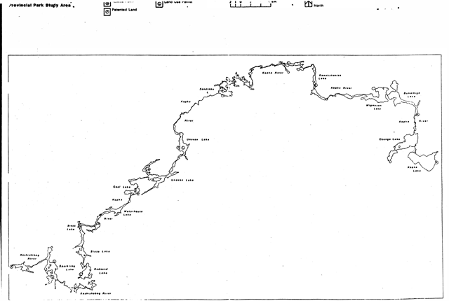
Map of Kopka River Provincial Park
- Name: Kopka River
- Class: Waterway
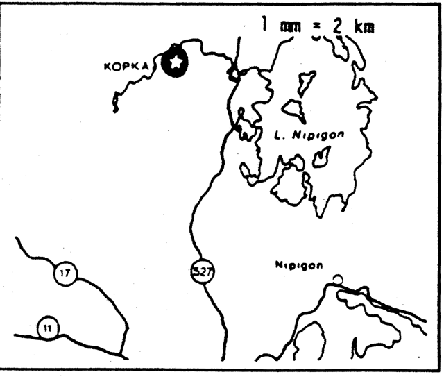
- M.N.R. district: Nipigon, Thunder Bay
- M.N.R. region: North Central
- Total area: (ha) 16,200
- Land: [no information provided]
- Water: [no information provided]
- Site region: 3W
- Site district: 2,3
- Date in Regulation: June 10, 1989
Targets
Life science representation
- Site type/landscape unit:
- Flat to gently sloping sand dune plain (Kopka Lake).
- Others undocumented.
- Species/communities:
- Jack Pine stand.
Earth science representation
- Geological theme:
- Timiskaming Interstadial.
- Aeolian landform/process.
- Others undocumented.
- Feature:
- Eastern outlet glacial Lake Agassiz (Kopka Lake).
- Dune complex (Kopka Lake)
Cultural resource representation
- Theme: Unknown
- Theme segment: [no information provided]
Recreation opportunities
- Day use: Not Applicable
- Car camping: Not Applicable
- Wilderness/back country: Not Applicable
Inventories
| Level/type | Reconnaissance/Completion Date | Detailed completion date | Required? |
|---|---|---|---|
| Earth science | Checksheet (Kopka Lake) | Checksheet (Kopka Lake) | Detailed inventory |
| Life science | Detailed inventory | ||
| Cultural | Detailed inventory | ||
| Recreational | |||
| Other |
Kopka River Candidate Waterway Provincial Park interim management statement
I. Land tenure
All land within the Park is Crown Land.
There are eight land use permits within the Park. All are for fly-in tourism operations.
There is a reservation for surface rights disposition covering approximately two miles of the waterway (Mining Act Section 36, File #188538).
Guideline
Further granting of tenure will not be considered for any land within this Park.
No additional land use permits will be issued. Existing land use permits will be allowed to continue and their future will be addressed in the Park Management Plan.
Mining will not be within the Park.
II. Land acquisition/disposition
There is no patented land within the Park area.
There is one patented parcel of land which is surrounded by the Park (Summer Resort Location #HK271, Uneven Lake, 1.1 hectares). This property is excluded from the Park, (The property owner’s name and address is on file in the Thunder Bay District Office.)
Guideline
No consideration will be given to acquiring additional land within the Park.
The disposition of approximately 1.2 hectares of land, for the purpose of expanding Summer Reserve Location #HK271 on Uneven Lake will be considered in the development of the Park Management Plan.
No consideration will be given to additional disposition of land within the Park until the Park Management Plan has been completed.
III. Existing/proposed development
There are three established access points within the Park. One is at the western extremity of the Park, and is accessed off the Graham Road. The development at this site includes a boat launch and six campsites. The other access points are located at Bukemiga and Kopka Lakes, at the eastern extremity of the Park. At the Bukemiga lake access point, boat launching is provided but there are no developed campsites. (Camping is allowed and does take place in the beach area.) At the Kopka Lake access point there are five campsites, a natural boat launch and earth pit privies.
The Kopka River has been crossed by the Great West Timber Company haul road via two bridges. There are no developed access points at these locations.
The entire length of the waterway is an official M.N.R. canoe route. The only development related to the canoe route are portages, which presently receive minimal maintenance.
Guideline
Controlled development and expansion of the three access points will be undertaken if funds are available. A Site Plan will be and approved prior to any work on these areas.
In the Nipigon District portion of the Park, no further crossing s of the river will be permitted. In the portion of the Thunder Bay District, within the Spruce River F.M.A. area, any crossings of the river will be discouraged. In the remainder of the Thunder Bay District portion of the Park, no crossings of the river will be permitted.
Portages will be cleared and upgraded to proper standards, if funding permits.
Excepting as noted above, development (excluding that related to public health and safety) will not be undertaken prior to completion of a Management Plan.
IV. Recreational activities
The Kopka River is classified as a Waterway Provincial Park.
Present recreational activities include canoeing, boating, fishing, bathing, hunting. camping and wildlife viewing, not necessarily as single uses but more as integrated, many faceted activities.
Guideline
All of the above activities will be allowed to continue. If any unforeseen conflicts develop in the future (e.g., hunting vs. camping), necessary restrictions will be implemented.
V. Commercial activities
Commercial tourism, (fly-in fishing and hunting camps) and trapping presently occur in the Park.
There are three traplines and three trapline cabins within the Thunder Bay District portion of the Park, and six traplines and two traplines cabins with the Nipigon District portion of the Park. (Trapline data is on file in the Thunder Bay and Nipigon District Offices.)
The Park area has been withdrawn from staking.
There are five active Bait Fish Licences in the Park. (The Bait Fish Licence holders’ names and addresses are on file in the Thunder Bay and Nipigon District Offices.)
No additional commercial activities presently exist.
Guideline
Tourism and bait fishing will be the only commercial activities allowed in the Park.
Trappjng will be allowed to continue only for Status Indians enjoying treaty rights. Otherwise it will be phased out by January 1, 2010 or when the trapper retires or dies, whichever is sooner.
The present trapline cabins will be allowed to stay within Park. No additional cabins will be permitted within the Park boundary.
Forestry, commercial fishing, mining and aggregate extraction will not be permitted in the Park.
Other commercial activities will not be permitted.
VI. Natural resources
There is little detailed information on the earth and life science resources within the Park area.
There are two known Osprey nesting sites (Gaal Lake and Seiss Lake). These are identified in the Thunder Bay District Sensitive Areas Report.
Guidelines
Osprey nesting will be protected in accordance with in the Thunder Bay District Sensitive Areas Report.
Normal forest fire suppression will take place within the Park area.
Until appropriate measures are in a Management insects and diseases will be controlled as is deemed necessary.
VII. Cultural resources
There have been no detailed inventories of cultural resources within the Park. The potential for the existence of archaeological sites is considered high.
Guidelines
A detailed inventory of cultural resources will be undertaken prior to completion of a Management Plan.
Any disturbance to potential and/or identified cultural resources within the Park will be discouraged and restrictions on activities on or n ear the sites will be implemented if necessary.
VIII. Client services
The only client service provided at the present time is the provision of canoe route informational brochures.
Guidelines
Canoe route informational brochures will continue to be made available to the public, as long as existing supplies remain. If funds are available, existing brochures will be updated and improved.
Additional client services will not be provided until a Management Plan has been completed, except as required by legislation or M.N.R. Policy.
IX. Research/inventories
Presently, there have been no earth/life science or cultural resource inventory checksheets completed, except for Kopka lake. Kopka Lake has had a brief life/earth science inventory checksheet completed.
Lake surveys have been completed for all lakes except Aino and Kenakskanis Lakes.
Guidelines
Detailed earth/life science and cultural resource inventories will be conducted prior to completion of a Management Plan.
Lake surveys will be completed for Aino and Kenakskanis Lakes.
References/sources
O.M.N.R. Abitibi-Price Inc. Spruce River Forest – Forest Management Agreement #500700 - 1981.
O.M.N.R. 1983. Backgrounder Land Use Guidelines.
O.M.N.R. Earth Science Kopka Lake.
O.M.N.R. Life Science Checksheet Kopka Lake.
O.M.N.R. 1983. Nipigon District Land Use Guidelines.
O.M.N.R. 1983. Thunder Bay District Land Use Guidelines.
O.M.N.R. Sensitive Areas Report. Thunder Bay District.
Map of Kopka River Provincial Park study area