Lake of the Woods Waters Conservation Reserve Management Statement
This document provides policy direction for the protection, development and management of the Lake of the Woods Waters Conservation Reserve and its resources.
Statement of Conservation Interest
Prepared for: OMNR, Northwest Region
Kenora District, OMNR
June 2005
Approval statement
We are pleased to approve this Statement of Conservation Interest for the Lake of the Woods Waters Conservation Reserve.
This Statement of Conservation Interest provides guidance for the management of the conservation reserve and the basis for the ongoing monitoring activities. More detailed direction at this time is not anticipated. Should significant facility development be considered, or if complex issues arise which require additional studies, more defined management direction, or special protection measures, a more detailed Conservation Reserve Resource Management Plan will be prepared with full public consultation.
The public was widely consulted during the original regulation process and further public consultation is not required at this time.
The conservation reserve will be managed under the jurisdiction of the Lake of the Woods Area Supervisor, Kenora District, Ministry of Natural Resources.
Fred S. Hall
District Manager
Kenora District
Charlie Lauer
Regional Director
Northwest Region
1.0 Background information
During the Lands For Life process, areas representative of Ontario’s diverse ecosystems and biological/geological features were identified and recommended for regulation as parks and protected areas under the Provincial Parks Act and the Public Lands Act, respectively (OMNR, 1999). Ontario’s Living Legacy increased the percentage of Ontario’s protected areas to encompass twelve percent of the province’s land and water base. The Lake of the Woods Waters Conservation Reserve is one of the representative areas selected for protection in ecodistrict 5S-2, and regulation is anticipated in 2005.
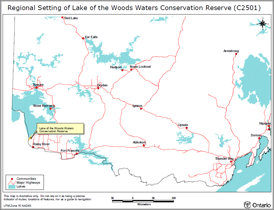
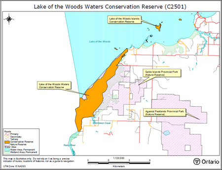
The Lake of the Woods Waters Conservation Reserve is a water-based reserve, consisting of 1,984 hectares of open waters and wetlands (OMNR, 1999; OMNR 2002). It is located 15 kilometers northwest of the Town of Rainy River. Please refer to Appendix A and B for maps of the area. The area was selected as a candidate under Ontario’s Living Legacy to provide continuity of protection for the water between the mainland and the offshore barrier-islands of the Sable Islands Provincial Nature Reserve (OMNR, 1999).
Based on proximity to the conservation reserve, potential Aboriginal interests in the area include Big Grassy, Big Island, and Rainy River First Nation. All of these First Nation communities are members of Treaty 3.
The intent of this Statement of Conservation Interest is to identify the natural heritage values and the activities occurring within Lake of the Woods Waters Conservation Reserve. Furthermore, by outlining management guidelines, this document will describe activities that are permitted or prohibited in the conservation reserve. For further information regarding the basis of this Statement, please refer to the "Conservation Reserve Policy and Procedure PL3.03.05", specifically, pages 2-6 and 14-22 of the procedure (OMNR, 1997a).
| Name | Lake of the Woods Waters Conservation Reserve |
|---|---|
| Site Region / Site District | 5S-2 |
| OMNR Administrative Region / District / Area | Northwest / Kenora / Lake of the Woods |
| Total Area (ha) | 1,984 ha |
| Regulation Date | Anticipated for 2005 |
| First Nations with Interest in Area | Big Grassy, Big Island and Rainy River |
| OBM | 2015370054100 |
| UTM | 15T 379000 E 5415000 N (NAD 83 projection) |
| Latitude/Longitude | 48° 53' N 94° 39' W (projection: NAD 83) |
| Basemap | 37541, 38541, 38542 |
| Forest Resource Inventory Stand Numbers (Partially or Wholly Represented Within the Reserve) | None |
| General Location Description | The waters of Lake of the Woods bordered by the Sable Islands and the mainland. The reserve includes Quick Island to the north and extends southwest to the Canada-US border at the delta of the Rainy River. It is located 15 km northwest of the municipality of Rainy River (Appendix A) |
| Access | Boat and floatplane can access the conservation reserve. During the winter, snowmobiles can access the conservation reserve |
1.1 Representation targets
This section provides a summary of the earth and life science values, recreational uses and cultural resources represented in the Lake of the Woods Waters Conservation Reserve.
| Life Science Representation | The Lake of the Woods Waters Conservation Reserve contains significant wetland communities and shallow open water lagoon areas that provide productive habitat for an array of fish and wildlife species (MNR, 2002)
|
|---|---|
| Earth Science Representation | The Lake of the Woods Waters Conservation Reserve represents part of a very large sand barrier island – lagoon complex, a unique feature to the Canadian Shield. (MNR, 2002).
|
| Cultural Resource Representation | No archeological sites or artifacts have been identified or recovered within Lake of the Woods Waters Conservation Reserve. There are 10-15 registered sites in the near vicinity and undiscovered artifacts may be present within the site. The area has a long history of human use, beginning 8,500 years ago with the Palaeo culture. Traditional uses include fishing for lake sturgeon and wild rice collection. (OMNR, 2002) |
| Recreational Opportunities | The beaches of the adjacent Sable Islands attract visitors to swim, picnic and boat. The conservation reserve offers a sheltered channel and mooring areas. Canoes and kayaks explore the relatively sheltered waters. A main boat route, traveling between Lake of the Woods and the Rainy River, crosses through the site. Fishing in both the summer and winter is popular. In the fall, waterfowl hunting occurs. During the winter, a snowmobile route (Balford Trail) passes through the reserve. |
1.2 Survey information
This section provides an overview of the inventories completed and their associated level of detail. At present, no further inventories are required.
| Survey Level | Reconnaissance | Detailed |
|---|---|---|
| Life Science | Checklist and summary report, 2003. Survey conducted via helicopter and boat. | Not required |
| Earth Science | Checklist and summary report, 2003. Survey conducted via helicopter and boat | Not required |
| Cultural | File review: MNR District files. Review of Ministry of Citizenship, Culture and Recreation database | Not required |
| Recreational | Recreational assessment, 2002 | Not required |
2.0 Significant values for protection
This section provides a description of the key natural heritage values on the site, their condition relative to past resource use and management activities, as well as their sensitivity to future land use and management activities. The purpose of Lake of the Woods Waters Conservation Reserve is to provide a continuity of protection for the habitat and landforms between the mainland and offshore barrier-islands of the Sable Islands Provincial Park – Nature Reserve (OMNR, 1999). Therefore, consideration has been given to values of the adjacent Sable Islands Provincial Nature Reserve which may be impacted by activities within the conservation reserve.
Rare species listed will be followed by a ranking (i.e. S3), which indicates the provincial rarity as explained in Appendix D.
2.1 Life sciences
Lake of the Woods Waters Conservation Reserve consists of a species-rich mix of shallow, lacustrine, open water and approximately 250 ha of emergent and submergent marshlands (NRVIS data). Additionally, significant riverine wetlands surround McGinnis Creek and the Rainy River delta (Foster et al, 2003A). These habitats support a good diversity of wildlife including beaver, muskrat and river otter. Additionally, there are several species at risk and rare species found within the conservation reserve. Many of the life science elements are sensitive to human disturbance and environmental degradation.
Biologist Dr. Rob Foster and geologist Charlie Blackburn reported that:
Lake of the Woods Waters Conservation Reserve is provincially significant for its estuarine and lacustrine wetlands, fish nursery and spawning habitat, nesting habitat for imperiled Black Terns, Yellow-headed Blackbirds and other species at risk, and its regional importance as a migratory stopover.
(Foster et al, 2003)
In recognition of the area’s significance to birds for migration, nesting and staging, the conservation reserve and the surrounding lagoon – sand beach complex are designated as part of Lake of the Woods Sand Spit Archipelago Important Bird Area (Wilson et al, 2002).
2.1.1 Species at risk
Lake of the Woods Waters Conservation Reserve provides habitat for a number of threatened species. Rare plant species include the nationally endangered small-flowered lipocarpha (Lipocarpha micrantha) (also called Dwarf Bulrush) (S1). This is one of two known sites where L. micrantha occurs in Ontario (Foster et al, 2003A). The species still requires that a recovery plan be developed for its protection.
A very productive estuarine wetland provides spawning and nursery habitat for fish, including provincially rare Lake Sturgeon (Acipenser fulvesens) (S3) and Longear Sunfish (Lepomis megalotis) (S3) (Foster et al, 2003A; Foster 2003B). Adult Lake Sturgeon forage and use the area as a staging ground before spawning further upstream in the Rainy River (Foster et al, 2003A).
The provincially significant Northern Long-eared Bat (Myotis septentrionalis) (S3), is found in the adjacent nature reserve and is likely to forage over the waters of the conservation reserve.
The locally abundant, but provincially endangered, White Pelicans (Pelecanus erythrorhynchos) forage in the waters. The Black Tern (Childonias niger) (ranked Vulnerable in Ontario & classed S3B) colony has been estimated at 75 pairs (Foster et al, 2003A). The Yellowed-headed Blackbird colony has an estimated 100 pairs (Foster et al, 2003A). Yellow Rails (Coturnicops noveboracensis) (S4B) are considered provincially vulnerable and of special concern nationally. These birds nest in significant numbers in Big Marsh within the adjacent nature reserve and may forage or nest in the conservation reserve. The provincially endangered Bald Eagle (Haliaeetus leucocephalus) forages in the area.
The nationally endangered Piping Plover (Charadrius melodus) made nesting attempts on the adjacent Sable Islands in the summer of 2002. These nests were washed out due to high water levels. Piping Plovers are a species at risk; historically distributed along the Great Lakes, they are now considered extirpated as a breeding population in Canada. They made known nesting attempts at only two locations in Ontario, both on Lake of the Woods. (The Green Lane - Environment Canada, 2002). The Plovers are likely to forage on mudflats in Lake of the Woods Waters Conservation Reserve. There is a Recovery Plan in place for this species at risk. Rising lake levels after nests are established in mid-May to June threaten the Plover.
2.1.2 Wildlife
Mammals that inhabit the conservation reserve include Muskrat, Mink, River Otter and Beaver.
Located on the Central Mississippi Flyway, a great diversity of birds can be observed in this area during migration. The avian fauna includes White Pelicans, Bald Eagles, Yellow-headed Blackbirds, Sandhill Cranes, Double Crested Cormorants, Franklin’s Gulls, Bonapart Gulls, Black Terns and numerous other shorebirds. It is probable that Snipe and Woodcock use flattened areas of wetland meadows as a staging ground. The adjacent nature reserve has recorded 256 bird species, 137 of which have been confirmed as nesting. Many of these species will also use the conservation reserve.
2.1.3 Forest values
Lake of the Woods Waters Conservation Reserve is predominantly a water- based area. The 21 ha of 'land' within the conservation reserve mostly consists of a thicket swamp and meadow marshes over peatlands (Foster et al, 2003A). This thicket swamp forms the only forested area, consisting of a thin strip of treed willows and balsam poplar swamp along the mainland strip south of McGinnis Creek. (Foster et al, 2003A). There is no merchantable timber.
The conservation reserve has been removed from the Crossroute Forest Management Unit 405 that is issued to the Fort Frances Division of Abitibi- Consolidated Inc. (Ontario Parks, 2002). No harvest blocks were allocated within the conservation reserve boundaries during previous Forest Management Planning processes.
2.2 Earth sciences
Lake of the Woods Waters Conservation Reserve is a lagoon, enclosed by eight kilometers of sandy barrier-islands. The conservation reserve lies within the Wabigoon Belt of the Superior Structural Province of the Canadian Precambrian Shield. The bedrock consists of Archean, mafic metavolcanics (rocks high in magnesium and iron) of the Rainy River greenstone belt and smaller amounts of granites (Blackburn, 2003). The bedrock is overlain by Pleistocene glacial tills and Quaternary deposits of sand and clays (Blackburn, 2003). The later Quaternary deposits result from two glacial periods and later lacustrine processes from Glacial Lake Agassiz. In turn, the lacustrine clays are overlain by organic material, the result of extensive peatlands that cover the eastern shoreline (NHIC, 2000B). Lacustrine deposits from post-glacial Lake Agassiz resulted in stratified layers of clay, silty clay, silty sands, and sands. Glacial processes continue to impact water levels in the southern end of the lake. This large barrier-island and accompanying lagoon landform is highly unusual in Northern Ontario, particularly on the Precambrian Shield.
For a more detailed description of the Earth Science features of the conservation reserve, please refer to the Lake of the Woods Waters Conservation Reserve Recreation Inventory Report, Section 3.5: Earth Science Values.
2.3 Cultural/historical significance
There are no registered archeological sites/artifacts identified or recovered within the Lake of the Woods Waters Conservation Reserve (von Bitter, 2002). However, there are 10-15 registered sites in the near vicinity and it is possible that undiscovered artifacts may be found in the water covered areas of the conservation reserve (von Bitter, 2002).
The mouth of the Rainy River is of historical significance as a voyageur route, a gateway used for early European exploration on Lake of the Woods, and finally used in establishing the Canada-United States border.
Please refer to the Recreation Inventory Report, Section 3.2 Cultural Values, for a detailed description of the history of human use in the area.
2.4 Aboriginal values
Lake of the Woods Waters Conservation Reserve is within the Treaty 3 area. Potentially interested First Nations include Big Grassy, Big Island, and Rainy River. There are no current land claims within the conservation reserve.
During low water years, wild rice stands are thought to grow in the wetland area and the grains are traditionally harvested by First Nations. Lake Sturgeon are a culturally significant food source for First Nations, and are harvested in very small numbers in the Rainy River area. The Rainy River First Nation is known to exercise hunting and fishing rights in the area (Wilson et al, 2002).
2.5 Recreational values
Sport fishing, migratory bird hunting, swimming, boating, canoeing and picnicking are recreational activities that occur within and directly adjacent to the conservation reserve.
2.5.1 Recreational fishing
The shallow, warm waters of Lake of the Woods Waters Conservation Reserve provide angling opportunities for Smallmouth Bass, Northern Pike, Walleye, Sauger and Yellow Perch. Both resident and non-resident anglers fish this area.
2.5.2 Recreational boating
A main boat route travels through the conservation reserve which connects the Rainy River to the Lake of the Woods. Motorized boats are the most common means to access the site and the adjacent Sable Islands.
2.5.3 Recreational hunting
Lake of the Woods Waters Conservation Reserve falls within Wildlife Management Unit 10 (WMU 10). Species such as Mallards, Ringnecks, Buffleheads, Teals, Black Ducks, Gadwall, Widgeons, Pintails, and Scaup are targeted for waterfowl hunting (OMNR, 2002). The adjacent nature reserve is a no hunting zone.
2.5.4 Trails and routes
The Morson and Balford Trails are snowmobile routes that enter the conservation reserve through the break in the barrier islands and continue along the Rainy River.
2.6 Fishery Resources: Commercial fishing, baitfish & leech blocks
Portions of two baitfish license blocks, both identified as FF937, overlap Lake of the Woods Waters Conservation Reserve. Portions of two Leech Blocks, 488943 and 487943 overlap the conservation reserve. (It should be noted that baitfish and leech harvest is not permitted within water bodies in the adjacent nature reserve.)
Currently, no commercial fishing is carried out within Lake of the Woods Water Conservation Reserve. However, an existing trap net license covers a portion of the conservation reserve.
2.7 Furbearers
Populations of furbearers such as beaver, otter, muskrat and mink inhabit the area. Three Residential Trapline areas, administered by OMNR-Fort Frances District, overlap Lake of the Woods Waters Conservation Reserve (FF02194001, FF03194001, FF04194001). No furbearers have been harvested from these traplines since 1997 (MNR-FURMIS data). Local First Nations may be exercising their Aboriginal and Treaty rights to harvest fur in the area, however no signs of trapping have been documented (Ontario Parks, 2002).
2.8 Commercial tourism
There are no tourist lodges/outposts located within Lake of the Woods Waters Conservation Reserve. Nearby, there are two private campgrounds, Camp of the Woods and Oak Grove Camp, located on the Rainy River. Both of these campgrounds promote the Sable Islands as a point of interest for their visitors. Within thirty kilometers there are numerous lodges, hotels, houseboat rentals and marinas.
2.9 Mineral resources
There is no known mineral potential within the conservation reserve and mining is not known to have occurred within the site.
2.10 Aggregates
Fine sands form the substrate of the conservation reserve and the adjacent Sable Islands. No previous aggregate extraction activities are recorded.
3.0 Management guidelines
The following section briefly describes the management guidelines to be implemented for various existing or potential activities within the conservation reserve. Refer to Appendix C for an expanded table of permitted uses. Note that this table will be revised periodically. OMNR's Crown Land Use Atlas website, /page/crown-land-use-policy-atlas should be consulted for the current policy report.
It should be restated that the primary objective of Lake of the Woods Waters Conservation Reserve is to provide a continuity of protection between the mainland and offshore barrier-islands of the Sable Islands Provincial Park – Nature Reserve (OMNR, 1999). Therefore, it is considered beneficial to align the two governing policies prescribed by this Statement of Conservation Interest and the Sable Islands Provincial Nature Reserve: Interim Management Statement. (Copies of the Interim Management Statement can be obtained from Ontario Parks: Northwest Zone in Thunder Bay or the OMNR Fort Frances District.) Furthermore, the guidelines must protect the values of the conservation reserve and any activity/structure that threatens these values may result in policy amendments.
Background information and direction from the following documents has been considered in the development of this SCI:
Crown Land Use Atlas. OMNR. Website: Crown Land Use Policy Atlas /page/crown-land-use-policy-atlas
Kenora District Land Use Guidelines. 1983. OMNR.
Lake of the Woods Management Plan. 1977. OMNR.
Sable Islands Provincial Nature Reserve: Interim Management Statement. Ontario Parks.
Lake of the Woods Sand Spit Archipelago: Important Bird Area Conservation Plan. August 2002. William G Wilson & Edward D. Chesky.
Ontario Living Legacy: Land Use Strategy. July 1999. Ontario Ministry of Natural Resources.
Lake of the Woods Regulation Guide. 1991. Lake of the Woods Control Board
Lake of the Woods General Information Booklet. 1993. Lake of the Woods Control Board.
3.1 Land tenure & permits
The Lake of the Woods Waters Conservation Reserve consists entirely of Crown land. It is part of the Township of Spohn in the Rainy River District. There are no Land Use Permits (LUPs), leases, easements or other forms of tenure within the conservation reserve.
New dispositions of land, for private or commercial activities, will not be permitted within the conservation reserve. This direction is consistent with the management objective of providing a continuity of protection between the mainland and offshore barrier-islands of the Sable Islands Provincial Park-Nature Reserve. New dispositions of land may negatively impact the sensitive nature of the site and could increase disturbances of threatened species. Furthermore, these may be better accommodated outside the conservation reserve.
Applications for tenure to support activities with long-term structural components will not be considered. New commercial Restricted LUP applications may be considered where they are subject to a "test of compatibility" and are intended to support temporary, low-impact facilities/activities.
Fuelwood permits will not be issued within Lake of the Woods Waters Conservation Reserve because there are no property owners, leaseholders, or cottagers within its boundaries that would require fuelwood or trees for small- scale uses. The collection of deadwood for cooking and warmth fires is permitted, provided that reserve values are not impacted.
3.2 Existing and proposed development
There are no significant existing development features or structures that exist within the conservation reserve. No development of permanent private or commercial structures, (e.g. buildings, cabins, and roads) will be permitted within the conservation reserve. Low impact, temporary facilities may be considered only if a more detailed management plan approves them. Approval of any proposed facilities and associated uses must be subject to the "test of compatibility".
Minor man-made features within the area include old wooden piles which mark channels in the mouth of the Rainy River and McGinnis Creek. Additionally, navigational buoys mark the shifting boat channel between the Sable Islands into the Rainy River. Navigational buoys will be altered periodically as required for boat navigation. No dredging of the boat channel through the Rainy River delta is permitted within the conservation reserve.
OMNR and Ontario Parks signage will be permitted provided that natural heritage values are not affected. Signs may be erected to inform users about the important values within the conservation reserve and to educate users about permitted activities within the area. Care shall be taken when erecting and maintaining signs in order to minimize environment disturbance, particularly in sites and/or nesting areas known to support species at risk. No signs for the purpose of advertising will be permitted within the conservation reserve.
3.3 Recreational activities
Most recreational activities that have traditionally taken place within Lake of the Woods Waters Conservation Reserve may continue provided that they pose little threat to the natural ecosystems and features identified for protection within the conservation reserve (OMNR, 1997a).
3.3.1 Low-impact recreation
Activities such as wildlife viewing, swimming, canoeing, kayaking and picnicking will be permitted. Motorized boating within the conservation reserve is also permitted. The creation of a 'no wake' boating zone around sensitive nesting areas of threatened species, such as Black Terns and Piping Plovers, may be considered if recommended through further studies or planning processes.
3.3.2 Fishing
Sport angling is a permitted use within the conservation reserve. Please refer to the current Recreational Fishing Regulations Summary publication for applicable regulations.
3.3.3 Camping
Camping will be permitted within the conservation reserve, but it is unlikely to occur given that the area is almost entirely water.
3.3.4 Trails & boardwalks
There are no existing land-based trails within the conservation reserve. Consequently, in the absence of designated trails, ATV activity, horseback riding, mountain biking and snowmobiling will not be permitted on the land-based portions of the conservation reserve. It may not be consistent with the management objective of the conservation reserve to establish new trails to support these activities. Furthermore, new trails would likely impact the life sciences values within the conservation reserve. During the winter season these activities are permitted on the ice within the conservation reserve. 'Pedestrian only' trail/boardwalk development, with possible wildlife viewing platforms, would occur through management planning and may be approved subject to the "test of compatibility". However, construction of a trail/boardwalk connecting the mainland to the Sable Islands will not be supported. The increased recreational use that may result from such a trail could be detrimental to the life science values of the nature reserve. Additionally, it could serve as a corridor for predators of ground nesting birds, such as the Piping Plover.
3.3.5 Hunting
The conservation reserve is part of Wildlife Management Unit (WMU) 10. This site does not contain, in part or entirety, any Bear Management Areas.
Waterfowl hunting is a permitted activity within the conservation reserve. While hunting, both the hunter and the game animal must be within the conservation reserve because of the no hunting policy within the adjacent nature reserve. Note that it is illegal to hunt or carry firearms within the adjacent nature reserve (Ontario Parks, 2002). It is also illegal to shoot swimming animals, other than ducks.
3.4 Commercial activities
3.4.1 Wild food gathering
Wild rice harvesting for commercial use will be a permitted activity for First Nations persons only. Commercial harvesting of other wild foods (i.e. blueberry picking) will be determined through further management planning.
3.4.2 Trapping
Figure 1: Traplines of Lake of the Woods Waters Conservation Reserve
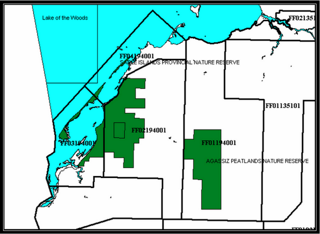
Three Residential Traplines (FF02194001, FF03194001 & FF04194001) overlap the conservation reserve. Resident Trapline holders can trap on Crown land and any private lands authorized by landowner permission (Ontario Parks, 2002; MNR district files). New or modified trapline boundaries will be considered subject to the "test of compatibility". No trapping cabins currently exist within the conservation reserve and the development of new trapper cabins is not permitted as per Conservation Reserve Policy (May 2003).
First Nations may exercise their Aboriginal and Treaty rights to harvest fur in the conservation reserve, however no signs of trapping are documented (Ontario Parks, 2002). Note that trapping is being phased out of the adjacent nature reserve by January 1, 2010 (Ontario Parks, 2002).
3.4.3 Bait-fishing & leech blocks
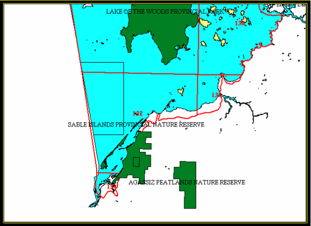
Two bait-fish license blocks within the conservation reserve, both identified as FF937, are currently in use. Additionally, portions of two Leech Blocks, 488943 and 487943, are currently operated.
Bait-fish and leech harvesting are permitted to continue unless there are significant demonstrated conflicts. No opportunities for new operations exist as all harvest blocks have been allocated in the past. Requests for transfers may be considered subject to the "test of compatibility." These management directions are in accordance with Conservation Reserve Policy (May 2003).
Figure 2: Bait-fish blocks intersecting Lake of the Woods Waters Conservation Reserve
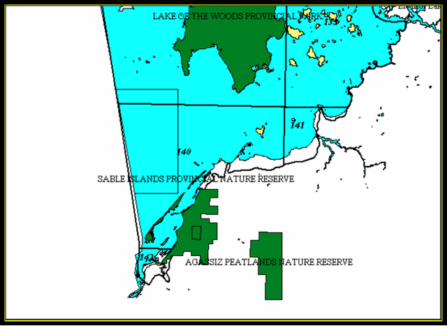
Figure 3: Leech blocks intersecting Lake of the Woods Waters Conservation Reserve
3.4.4 Commercial fishing
Currently, no commercial fishing is carried out within Lake of the Woods Waters Conservation Reserve. However, trap net license #47 includes a portion of the conservation reserve. New operations will not be permitted as they could compromise efforts to protect the rare fish species that exist in the area, as well as threaten important fish nursery and staging habitat.
3.4.5 Forest harvest
The very small area of wetland thicket is not merchantable timber and historically has not been logged. The forest stands within the conservation reserve boundaries are protected from any alteration resulting from forest management activities (OMNR, 1999; 1997a). Therefore, commercial timber harvest will not be permitted within the conservation reserve as per Conservation Reserve Policy.
3.4.6 Commercial hydro development
There is no potential for hydro development at the site. Furthermore, hydro development is not a permitted activity within conservation reserves as per Conservation Reserve Policy (May 2003).
3.4.7 Energy transmission/communication corridors
No energy transmission/communication corridors or cables exist within the conservation reserve. The creation of new energy transmission/communication corridors or cables within the conservation reserve could compromise the primary objective of the conservation reserve and could strongly impact life science values. Furthermore, these corridors could be better accommodated outside of the conservation reserve. Therefore, energy transmission/communication corridors will not be supported within the conservation reserve unless there are no demonstrated alternatives.
3.4.8 Mining, aggregate and peat extraction
There are no mines, aggregate pits or peat extraction activities currently occurring within the conservation reserve and this area has been withdrawn from all mining exploration and extraction activities by the Ministry of Northern Development and Mines (MNDM). No future exploration, development or extraction is permitted as per Conservation Reserve Policy.
3.4.9 Commercial tourism
Currently, no outfitting services, outpost camps or resorts/lodges are located within the conservation reserve. New temporary low impact facilities may be considered through further management planning. Proposals for any of these facilities, and their associated uses, will be subject to the "test of compatibility". However given that the conservation reserve is mostly water, commercial tourism facilities may not be feasible.
3.4.10 Non-resident, guided bear hunting: Bear Management Areas
Figure 4: Bear Management Areas adjacent to Lake of the Woods Waters Conservation Reserve
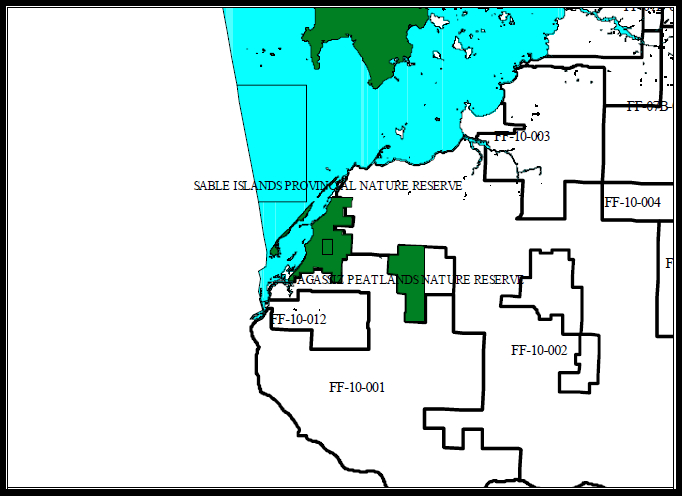
The conservation reserve does not contain any Bear Management Areas (BMA). Consequently, guided, non-resident bear hunting is not permitted. New BMA operations are not permitted as per Conservation Reserves Policy (May 2003).
3.5 Aboriginal interests
Lake of the Woods Waters Conservation Reserve is within the Treaty 3 area. First Nations within the area may have an interest in the conservation reserve. Aboriginal and Treaty rights supercede this Statement of Conservation Interest.
3.6 Natural resources stewardship
3.6.1 Vegetation management
Featured Species Management and Natural Systems Management may be permitted. Non-native species will not be deliberately introduced within the conservation reserve. Where established introduced species threaten the life science values in the conservation reserve, a management plan and program may be developed for their control. Vegetation management can be considered through more detailed management planning.
3.6.2 Fire suppression and prescribed burning
The MNR recognizes fire as an essential process fundamental to the ecological integrity of conservation reserves. In accordance with existing Conservation Reserve Policy and the Forest Fire Management Strategy for Ontario, forest fire protection will be carried out as on surrounding lands.
Whenever feasible, the MNR fire program will endeavour to use "light on the land" techniques, which do not unduly disturb the landscape, in this conservation reserve. Examples of light on the land techniques may include limiting the use of heavy equipment or limiting the number of trees felled during fire response efforts.
Fire is unlikely to occur within this conservation reserve. However, there is the potential for vegetative mats to burn during exceptionably dry years, when low water levels occur. Suppression of this type of root burn is almost impossible until it emerges above ground. There is some support for this type of burn as a wetland management technique, and it is felt that the occasional burning of root masses can increase plant diversity.
Opportunities for prescribed burning to achieve ecological or resource management objectives may be considered. These management objectives will be developed with public consultation prior to any prescribed burning, and reflected in the document that provides management direction for this conservation reserve. Plans for any prescribed burning will be developed in accordance with the MNR Prescribed Burn Planning Manual, and the Class Environmental Assessment for Provincial Parks and Conservation Reserves.
3.6.3 Insect & disease suppression
Insect and/or disease events may be allowed to occur provided that they do not threaten the values that the conservation reserve aims to protect. Suppression of infestations by non-native species may be permitted subject to the 'test of compatibility'.
3.6.4 Fisheries and wildlife management
Fisheries and Wildlife Management within the conservation reserve shall promote and protect the maintenance of natural features and functions (i.e. succession, dune formation, etc.). Due to the interrelated nature of the conservation reserve and the adjacent nature reserve, concurrent management planning should be carried out to ensure that their objectives and management strategies are compatible.
As previously mentioned, sport fishing and migratory bird hunting will be permitted activities, subject to regulations and management directions. These are discussed in further detail in section 3.3.5: Hunting and 3.3.2: Recreational Fishing.
Species management within the conservation reserve may be permitted through more detailed management planning. This is of particular importance to species at risk, as well as species that stage, nest and forage in the area. The OMNR will continue to fulfill its role in Recovery Plan Implementation for Species at Risk, such as the Piping Plover. Management activities for the Plover include monitoring, placing signage around nests to discourage traffic, and erecting predator exclosures. Further details can be found within the Piping Plover Recovery Plan.
3.6.5 Landforms
The landforms represented within Lake of the Woods Waters Conservation Reserve will not be altered through any landform modification activities, including filling and extracting of aggregates, peat, soils, and similar materials (OMNR, 1997a).
3.6.6 Water level management
Application will be made by the OMNR to the Canadian Lake of the Woods Control Board (LWCB), and if necessary the International Joint Commission (IJC), in order to protect natural resource values within the conservation reserve. MNR biologists and other district staff are currently working with the Lake of the Woods Control Board to reduce the impacts to natural resources resulting from water-level manipulations (Biologist Barry Corbett pers. comm. 2003; Wilson et al, 2002).
Inflows to Lake of the Woods are controlled by the Rainy Lake and Namakan Reservoir hydro dams, upstream on the Rainy River, which accounts for 70% of the lake’s water (Wilson et al, 2002). Two hydro dams in Kenora control the outflow. As an international water-body, rule curves which specify the allowable range of levels at each time of the year are developed and regulated by the IJC (Davis, 1997). The rule curves are based on multiple factors including Municipal Water Supply, fisheries, waterbirds, hydro generation, property damage control, tourism, boating, and wild rice.
The level of Lake of the Woods must be maintained within an elevation of 1056 ft. (321.87 m) and 1061 ft. (323.47 m) (USACE, 2003; LWCB, 1993). If the water level rises above or falls below that range, the International Lake of the Woods Control Board assumes control of the rate of discharge.
Unnatural and untimely lake-level fluctuations can adversely impact numerous natural features including Piping Plover nests, wild rice germination, fish spawning habitat, aquatic insects, amphibians, reptiles, and fur-bearers. (Wilson et al, 2002; Lake of the Woods Control Board, 1991; MNR Biologist Barry Corbert pers. comm. 2003; Heyens, 2002; OMNR, 2002; OMNR – Kenora District Files).
Water management targets:
The natural hydrological water-level pattern is of rising waters in early spring, peaking in late May or early June. This trend is followed by a slow drop-off throughout the summer, a rise in the fall and is followed by a slight drop throughout the winter. It would be beneficial to manage for more natural hydrological and biological conditions (LWCB, 1991: Wilson et al, 2002; MNR, 2002; Biologist Barry Corbett pers. comm., 2003).
Figure 5: Regulated Water Levels for Lake of the Woods
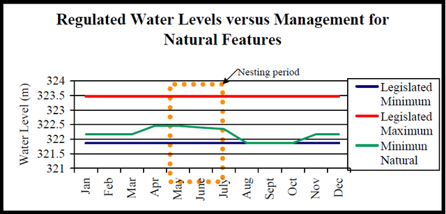
The Piping Plover is considered a nationally and provincially endangered species, therefore, a number of protective legislation comes to bare, including the provincial Endangered Species Act, the Migratory Birds Convention Act of 1994, and the soon to be passed federal Species at Risk Act (SARA). The manipulation of lake-levels that result in the destruction of Piping Plover nests could be viewed as a contravention of the aforementioned Acts and associated regulations.
3.7 Cultural resources stewardship
No archeological sites or artifacts have been identified or recovered within Lake of the Woods Waters Conservation Reserve. Further research may uncover culturally/historically significant occurrences within the conservation reserve boundary. Research may also help ensure their protection, provided that the research does not alter the identified values.
When exploring the site and surrounding area, any artifacts that are found should not be removed from the site, nor should historical pictographs be touched. It is requested that if any sites are found, please report and provide their location to the Ontario Ministry of Citizenship, Culture, and Recreation, Heritage and Libraries office.
3.8 Science, research, education and heritage appreciation
3.8.1 Science & research
The Ministry of Natural Resources must authorize any research occurring within the conservation reserve. Non-destructive research relating to natural, cultural and historical values within the conservation reserve could support this protected area’s primary objective. Expanded knowledge of the values of the conservation reserve will help ensure their protection and better management. Research needs and opportunities may develop out of subsequent management plans using adaptive management.
The MNR and Minnesota Department of Natural Resources are committed to conducting annual surveys of Piping Plover habitat and population size in their respective jurisdictions (Heyens 2002; Wilson et al, 2002). Additional monitoring of bird populations, species diversity and abundance, nesting information and trends within the Important Bird Area is ongoing by the MNR, Rainy River Valley Field Naturalists and Rainy River First Nations (Wilson et al, 2002).
3.8.2 Education and heritage appreciation
Nature appreciation, photography, painting, wildlife viewing and historical appreciation are permitted uses and are encouraged within the conservation reserve unless demonstrated conflicts occur. Sensitive areas (e.g. nesting sites) may be posted as off limits to various uses.
3.9 Client services
Information about this conservation reserve may be made available to the public so as to ensure that all resource users are aware of its location, recognized values, and permitted uses. Potential users include tourists, local anglers, duck hunters, trappers, recreationalists (e.g. snowmobilers), and the general public.
3.10 Marketing
There are no marketing requirements at this time.
4.0 Implementation
These management guidelines will be implemented immediately by Kenora District. Administrative responsibility for the conservation reserve rests with the Lake of the Woods Area Supervisor. Implementation will primarily involve monitoring activities to ensure adherence to the management guidelines. Any future planning should be completed in consultation with Ontario Parks with reference to the adjacent Sable Islands management plans.
5.0 Review and revisions
5.1 Review and revisions
It may be required to post any amendments to this Statement of Conservation Interest on the Environmental Bill of Rights (EBR) Registry prior to their approval. Consultation efforts may also be required, as determined by the Area Supervisor, as well as the approval of the District Manager and the Regional Director.
5.2 Public consultation
Timber companies, local communities, and the general public were contacted in March of 2003 regarding the regulation of Lake of the Woods Waters Conservation Reserve. Consultation efforts involved the direct mailing of a District information package to; local interest groups (such as the Local Citizens Committee), those with patent land, boat caches, trapline areas, baitfishing areas, and Sustainable Forest License holders within and/or adjacent to the conservation reserve’s proposed boundaries. In addition, newspaper advertisements were featured in the Kenora Enterprise and the Kenora Daily Miner and News in mid-March of 2003.
First Nation consultation associated with Lake of the Woods Waters Conservation Reserve is complete. The Grand Council Treaty #3 office hired an individual to assist both MNR and the area First Nations to complete these consultations. No comments specific to Lake of the Woods Waters Conservation Reserve were received.
6.0 References
Blackburn, Charles. 2003. Earth Science Inventory: Detailed Information for Site C2501 - Lake of the Woods Waters. Northern Bioscience Ecological Consulting.
Foster, R., and Harris, A. 2003A. Lake of the Woods Waters (C2501) Life Science Checksheet. Northern Bioscience Ecological Consulting.
Foster, R.; Harris, A. & Blackburn, C. 2003B. Earth and Life Science Reconniasance Surveys Summary Report. Northern Bioscience Ecological Consulting.
Heyens, Leo. September 2002. 2002 Ontario Report: Prairie Piping Plover Recovery Team. Unpublished report. Ontario Ministry of Natural Resources.
Historic Sites Initiative -Township of Sioux Narrows and Nestor Falls. 2002.
Historic Sites Initiative. Website: http://www.siouxnarrows-nestorfalls.ca/HistoricSitesInitiative.htm (link no longer active)
Davis, D.A. March/April 1997. Reassessing Water Levels-Workshop Explores Ways to Balance Interests Affected by Water Levels. International Joint Commission – focus. Website: http://www.ijc.org/rel/focus/v22i1/feat03.html
Lake of the Woods Control Board. 1991. Lake of the Woods Regulation Guide - Draft. Lake of the Woods Control Board.
Lake of the Woods Museum & Aulneau Adventure Tours. 2000. The Explorers' Guide to Lake of the Woods. Kenora, Canada.
Lund, Duane R. 1976. Lake of the Woods: Yesterday and Today. Nordell Graphic Communication. Minnesota, America.
Ontario Ministry of Natural Resources. 2002. Lake of the Woods Waters Conservation Reserve: Recreation Inventory Report. OMNR, Kenora.
Ontario Ministry of Natural Resources. 1999. Ontario’s Living Legacy – Land Use Strategy. OMNR.
Ontario Ministry of Natural Resources. 1997. Conservation Reserves Policy and Procedure. PL 3.03.05.
Ontario Parks. 2002. Interim Management Statement: Sable Islands Provincial Nature Reserve. Queen’s Printers.
Malaher, David G. January 2000. Rediscovering the Most Northwesterly Point of Lake of the Woods. Unpublished report.
Natural Heritage Information Center (NHIC). 2000A. Natural Areas Report: Spohn Township – Shoreline Marsh – Life Science Site. Queen’s Printer for Ontario. Website: http://www.mnr.gov.on.ca/MNR/nhic/areas/areas_report.cfm?areaid=17744 (link no longer active)
Natural Heritage Information Center (NHIC). 2000B. Natural Areas Report: Sable Islands Provincial Nature Reserve – Provincial Park Nature Reserve. Queen’s Printer for Ontario. Website: http://www.mnr.gov.on.ca/MNR/nhic/areas/areas_report.cfm?areaid=3202 (link no longer active)
Natural Heritage Information Center (NHIC). 2000C. Natural Areas Report: Sable Islands – Earth Science Site. Queen’s Printer for Ontario. Website: http://www.mnr.gov.on.ca/MNR/nhic/areas/areas_report.cfm?areaid=10646 (link no longer active)
Noble, T. and BAM Phillips. 1989. Earth Science Inventory – Sable Islands Provincial Nature Reserve. Queen’s Printer for Ontario. Toronto, Canada.
Schwimmer, Brian. 1998. Laurel Phase. Manitoba Archaeological Society – University of Manitoba. Website: http://www.umanitoba.ca/anthropology/manarchnet/chronology/woodland/laurel.html (link no longer active)
The Green Lane - Environment Canada. 2002. Piping Plover: Conservation and Management in Ontario. Website: http://www.mb.ec.gc.ca/nature/endspecies/pipingplover/db03s05.en.html (link no longer active)
United States Army Corps of Engineers (USACE). 2003. Lake of the Woods Control Board. Website: http://www.mvp-wc.usace.army.mil/ijc/low/low_board.html (link no longer active)
vonBitter, Robert. 2002. Database of Registered Archaeological Sites. Ministry of Citizenship, Culture, and Recreation.
Wilson, W. & Chesky, E. August 2002. Lake of the Woods Sand Spit Archipelago: Important Bird Area Conservation Plan. Published jointly by the Federation of Ontario Naturalists, Bird Studies Canada, Bird Life International and the Canadian Nature Federation.
Personal Communications:
Leo Heyens, MNR, 2003
Barry Corbett, MNR, 2003
Dave Fraser, Sunset Diving, 2003
Appendix A: Regional Setting of Lake of the Woods Waters Conservation Reserve (C2501)

Enlarge: Regional Setting of Lake of the Woods Waters Conservation Reserve
Appendix B: The Lake of the Woods Waters Conservation Reserve boundaries and locations of associated natural heritage and recreational values
Appendix C: Permitted Uses within the Lake of the Woods Waters Conservation Reserve (C2501)
Management direction:
Those uses and management activities not listed in the following table are governed by current Conservation Reserve Policy and Procedure.
Commercial activities
| Activity | Permitted | Guidelines |
|---|---|---|
| Aggregate Extraction | No | Not permitted |
| Bait Fishing Existing | Yes | Existing use permitted to continue, unless there are significant demonstrated conflicts. |
| Bait Fishing New | No | |
| Commercial Fishing Existing | N/A | No commercial fishing currently occurs. |
| Commercial Fishing New |
No | No new operations are permitted. |
| Commercial Fur Harvesting Existing | Yes | Existing use permitted to continue, unless there are significant demonstrated conflicts. |
| Commercial Fur Harvesting New | Maybe | New trapping operations can be considered subject to the "test of compatibility". There are no existing trap cabins. New trap cabins are not permitted. |
| Commercial Hydro Development | No | Not permitted |
| Commercial Timber Harvest | No | Not permitted |
| Commercial Tourism Existing | No | There are no existing authorized tourism facilities. |
| Commercial Tourism New |
Maybe | No new tourism facilities involving permanent structures can be considered. Temporary, low-impact facilities may be considered, subject to the "test of compatibility and through more detailed planning |
| Bear Hunting by Nonresidents (guided) Existing | Yes | Existing authorized operations permitted to continue. |
| Bear Hunting by Nonresidents (guided) New | No | New operations are not permitted. |
| Outfitting Services Existing | N/A | No existing authorized outfitting activities occur. |
| Outfitting Services New | Maybe | New operations, using low-impact, temporary structures, can be considered during the planning for an individual reserve. Permanent or long-term structures are not permitted. |
| Outpost Camps Existing | N/A | No existing authorized operations occur. |
| Outpost Camps New | No | New operations are not permitted. |
| Resorts/Lodges Existing | N/A | No existing authorized facilities occur. |
| Resorts/Lodges New | No | New facilities are not permitted. |
| Energy Transmission & Communications Corridors Existing | Yes | Existing utilities corridors are permitted. |
| Energy Transmission & Communications Corridors New | Maybe | New facilities should be strongly discouraged and are to avoid Conservation Reserve lands wherever possible. |
| Food Harvesting(Commercial) Existing | N/A | New food harvest operations may be permitted, subject to the test of compatibility or management planning. |
| Food Harvesting(Commercial) New | Maybe | |
| Mineral Exploration and Development | No | No mineral exploration or extraction is permitted. The reserve boundaries are considered to extend to 'the center of the earth'. |
| Peat Extraction | No | Not permitted |
| Wild Rice Harvesting Existing | Yes | Wild rice harvest may occur in the reserve, unless there are demonstrated conflicts. |
| Wild Rice Harvesting New | Maybe |
Land & resource management activities
| Activity | Permitted | Guidelines |
|---|---|---|
| Crown Land Disposition Private Use | No | Sale of lands is not permitted. No existing leases and land use permits occur in the reserve. No new leases or land use permits are permitted. |
| Crown Land Disposition Commercial Use |
Maybe | Only Restricted LUPs for commercial, temporary structures may be approved, subject to the 'test of compatibility'. Requests for transfer of Restricted LUPs will be considered in the context of the Statement of Conservation Interest or Resource Management Plan. |
| Fire Suppression | Yes | Fire suppression policies reflect those for adjacent Crown lands, unless alternative fire policies have been developed through a planning process. Fire suppression will be carried out using a means of least impact to the reserve. Ecological consideration will be given to permitting burns. Fire as a vegetation management tool, is subject to risk assessment and approval through a more detailed vegetation management plan. |
| Fish Habitat Management | Maybe | |
| Fish Stocking | Maybe | "Featured Species Management" may be permitted, subject to more detailed planning. Conservation Reserve management planning should be held in conjunction with a review of the Sable Islands Provincial Nature Reserve – as no stocking is permitted there. |
| Insect/Disease Suppression | Maybe | Suppression activities may be approved, subject to the test of compatibility. |
| Inventory/Monitoring | Yes | |
| Personal Use Permits for Wood Harvesting Existing | N/A | No permits for fuelwood harvest current exist. |
| Personal Use Permits for Wood Harvesting New | No | No new permits will be issued. Gathering of deadwood for cooking fires is permitted, provided reserve values are not significantly impacted. |
| Prescribed Burning | Maybe | Ecological consideration will be given towards the use of prescribed burns. Prescribed burns must undergo a risk assessment and be approved through a more detailed vegetation management plan. |
| Roads (Resource Access) Existing | N/A | No existing roads occur in the reserve. |
| Roads (Resource Access) New | No | New roads will not be permitted. |
| Vegetation Management | Maybe | Conservation Reserves Policy indicates that Featured Species Management and Natural Systems Management may be permitted. Vegetation management may be considered in a more detailed planning process. |
| Water Level Regulation Existing | Yes | Currently, water levels are controlled by the 2 dams in Kenora, and regulated at levels set by the International Joint Commission. |
| Water Level Regulation Future | Yes | Applications may be made to the IJC to manage levels for ecological considerations in the Conservation Reserve. |
| Wildlife Population Management | Maybe | Wildlife population management may be considered in a more detailed planning process. Currently, Piping Plovers, a species at risk that use the area, have an existing Recovery Plan. |
Science, education and heritage appreciation
| Activity | Permitted | Guidelines |
|---|---|---|
| Collecting | No | May be permitted as part of an authorized research project. The issuance of permits will be considered on a per-site basis. |
| Historical Appreciation | Yes | |
| Nature Appreciation | Yes | |
| Photography and Painting | Yes | |
| Research | Yes | |
| Wildlife Viewing | Yes |
Recreation activities and facilities
| Activity | Permitted | Guidelines |
|---|---|---|
| All Terrain Vehicle Use On Trails | Yes | No existing trails are located in the reserve. |
| All Terrain Vehicle Use Off Trails | No | ATV use off trails is not permitted, except for direct retrieval of game. |
| Campgrounds | No | Camping is not permitted in the reserve. |
| Food Gathering | Yes | |
| Horseback Riding (trail) | No | Riding is not permitted in the reserve, as there are no existing trails. |
| Hunting | Yes | Duck hunting is permitted in the reserve. |
| Mountain Bike Use | Yes | Biking is not permitted in the reserve, as there are no existing trails. |
| Motor Boat Use Commercial | Yes | |
| Motor Boat Use Private | Yes | |
| Non-motorized Recreation Travel | Yes | |
| Private Recreation Camps (Hunt Camps) Existing | N/A | No existing camps occur. |
| Private Recreation Camps (Hunt Camps) New | No | No new camps are permitted. |
| Rock Climbing | N/A | No potential for rock climbing exists |
| Snowmobiling On Trails | Yes | Existing uses permitted to continue where it does not adversely affect the values being protected. |
| Snowmobiling Off Trails | No | Snowmobile use off trails (on the land portion of the reserve) is not permitted, except that snowmobiles may be used for direct retrieval of game. Snowmobiles are permitted on ice, throughout the reserve. |
| Scuba and Skin Diving | Yes | |
| Sport Fishing | Yes | |
| Trail Development Existing | Yes | Existing trails will continue to be permitted, unless significant conflicts are demonstrated |
| Trail Development New | Maybe | Development of trails/boardwalk and observation towers for a variety of activities are permitted for pedestrian use. Trails/boardwalks for cycling, horseback riding, and snowmobiling are not permitted. Trails/boardwalks connecting the Sable Islands to the mainland are not permitted, due to impacts to species at risk. |
Source of Direction:
Ontario’s Living Legacy Land Use Strategy (1999).
Conservation Reserves Policy (1997)
Lake of the Woods Waters Statement of Conservation Interest (October, 2004)
Appendix D: Provincial ranking system for rare species
Provincial rank (SRANK)
Provincial (or Subnational) ranks are used by the Natural Heritage Information Centre to set protection priorities for rare species and natural communities. These ranks are not legal designations. Provincial ranks are assigned in a manner similar to that described for global ranks, but consider only those factors within the political boundaries of Ontario. By comparing the global and provincial ranks, the status, rarity, and the urgency of conservation needs can be ascertained. The NHIC evaluates provincial ranks on a continual basis and produces updated lists at least annually. The NHIC welcomes information that will assist in assigning accurate provincial ranks.
| Code | Ranking | Definition (Ontario specific) |
|---|---|---|
| S1 | Extremely rare | Usually 5 or fewer occurrences in the province or very few remaining individuals; often especially vulnerable to extirpation |
| S2 | Very rare | Usually between 5 and 20 occurrences in the province or with many individuals in fewer occurrences; often susceptible to extirpation |
| S3 | Rare to uncommon | Usually between 20 and 100 occurrences in the province; may have fewer occurrences, but with a large number of individuals in some populations; may be susceptible to large-scale disturbances. Most species with an S3 rank are assigned to the watch list, unless they have a relatively high global rank |
| S4 | Common | Apparently secure in Ontario; usually with more than 100 occurrences in the province |
| S5 | Very common | Demonstrably secure in Ontario |
| SH | Historical | Historical records but not verified recently (typically not recorded in the province in the last 20 years); however suitable habitat is thought to be still present in the province and there is reasonable expectation that the species may be rediscovered |
| SR | Reported | Without persuasive documentation which would provide a basis for either accepting or rejecting the report |
| SRF | Reported falsely | False report |
| SX | Apparently extirpated | Little likelihood of rediscovery. Typically not seen in the province for many decades, despite searches at known historic site. |
| SE | Exotic | not believed to be a native component of Ontario’s flora |
| SZ | Not of practical conservation concern inasmuch as there are no clearly definable occurrences; applies to long distance migrants, winter vagrants, and eruptive species, which are too transitory and/or dispersed in their occurrence(s) to be reliably mapped; most such species are non-breeders, however, some may occasionally breed | |
| SZB | Breeding migrants/vagrants | |
| SZN | Non-breeding migrants/vagrants | |
| SA | Accidental | Accidental or casual occurrence in the province; far outside its normal range; some species may occasionally breed in the province |
| SAB | Breeding accidental | |
| SAN | Non-breeding accidental | |
| C | Captive/Cultivated | existing in the province only in a cultivated state; introduced population not yet fully established and self-sustaining |
| S? | Not Ranked/Rank Uncertain | Not ranked yet, or if following a ranking, Rank Uncertain (e.g. S3?). S? species have not had a rank assigned |
| SU | Unrankable | Due to low search effort or cryptic nature of the species, there is insufficient information available to assign a more accurate rank; more data is needed |
Appendix E: The Test of Compatibility as defined by Conservation Reserves Policy (PL3.03.5)
Procedural guideline B - Land Uses - Test of Compatibility
The Conservation Reserve policy provides broad direction with regard to the permitted uses. The policy provides only an indication of the variety of uses that will be considered acceptable in conservation reserves. The only caution is that "any new uses, and commercial activities associated with them, will be considered on a case by case basis, and, they must pass a test of compatibility to be acceptable". What does a 'test of compatibility' mean?
An examination of this must start from the premise of why an area is set aside - specifically, its representative natural heritage values. Criteria are then identified to guide compatibility considerations. These criteria apply to the long term acceptability of both existing uses and new uses.
-
Conformity to SCI/RMP: SCI describe values for which an area has been set aside and the range of appropriate uses that will be permitted in the area. SCI may also speak to the acceptability of other 'new' uses currently not occurring in the area.
The first 'test' is: "do proposed new land uses and/or commercial activities conform to the direction of the SCIIRMP for the conservation reserve? Would the new use(s) depart from the spirit of appropriate indicator land uses in the SCI/RMP"?
- Impact Assessment: If the proposed use(s) pass test one it is important to determine their impact on the area before they are approved. This should include the following:
- impact on natural heritage values: "will the new use(s) impact any natural values in the area? If so how and to what degree? Is it tolerable?"
- impact on cultural values: "will the new use(s) impact any historical or archaeological values in the area?"
- impact on research activities: "will the new use(s) affect any research activities in the area?"
- impact on current uses: "will the new use(s) have any negative impact on the array of current uses?"
- impact on area administration: "will the new use(s) increase administrative costs and/or complexity?" (For example, the cost of area monitoring, security and enforcement)
- impact of accommodating the use outside the conservation reserve: "Could the use(s) be accommodated as well or better outside the conservation reserve?"
- impact on socio-economics of the area: "will the new use(s) affect the community(ies) surrounding the area in a positive or negative way?" For example, will the new use make the area less remote thereby affecting a local tourism industry that is dependent on the area’s remoteness for its appeal)?
- impact on area accessibility: "does the new use(s) give someone exclusive rights to the area or a portion of the area to the exclusion of other existing uses?"