Lighthouse Point Provincial Park Management Plan
This document provides policy direction for the protection, development and management of Lighthouse Point Provincial Park and its resources.
© 2005, Queen’s Printer for Ontario
Additional copies of this publication are obtainable from:
Wheatley Provincial Park
P.O. Box 640
Wheatley, Ontario N0P 2P0
Telephone: 519-825-4659
Prepared by Ontario Parks in cooperation with the Essex Region Conservation Authority, Ontario Nature, and Corporation of the Township of Pelee.
51728
(0.4k P.R., 05 08 05)
ISBN 0-7794-8822-9 (PDF)
Approval statement
I am pleased to approve the Fish Point and Lighthouse Point Park Management Plan.
This document contains Ontario Parks' policies and directional statements for the management of both Fish Point and Lighthouse Point Provincial Nature Reserves. In addition, it outlines an implementation strategy for the plan’s elements and summarizes the public consultation that has occurred. The public was encouraged to participate throughout the planning process. Public comments were considered in the development of this park management plan.
On behalf of Ontario Parks, I wish to express my genuine appreciation to our partners in the Pelee Island natural areas cooperative management planning process, namely, the Corporation of the Township of Pelee, Ontario Nature, and the Essex Region Conservation Authority.
Yours truly,
Signed by:
Adair Ireland-Smith
Managing Director
Ontario Parks
Date: July 7, 2005
Statement of Environmental Values and the Environmental Bill of Rights
In 1994, the Ontario Ministry of Natural Resources (OMNR) finalized its Statement of Environmental Values (SEV) under the Environmental Bill of Rights (EBR). The SEV is a document that describes how the purposes of the EBR are to be considered whenever decisions are made in the ministry that might significantly affect the environment. This includes decisions made as a result of a park management planning process.
The primary purpose of the EBR is "to protect, conserve and, where reasonable, restore the integrity of the environment." From the ministry’s perspective, that broad statement of purpose translates into four objectives in its SEV:
- to ensure the long-term health of ecosystems by protecting and conserving our valuable soil, aquatic resources, forest and wildlife resources as well as their biological foundations
- to ensure the continuing availability of natural resources for the long-term benefit of the people of Ontario
- to protect natural heritage and biological features of provincial significance; and
- to protect human life, the resource base and physical property from the threats of forest fires, floods and erosion
During the development of the Fish Point and Lighthouse Point Park Management Plan, the ministry considered its SEV. The Management Plan will further the objectives of managing Ontario’s resources on an environmentally sustainable basis.
1.0 Introduction
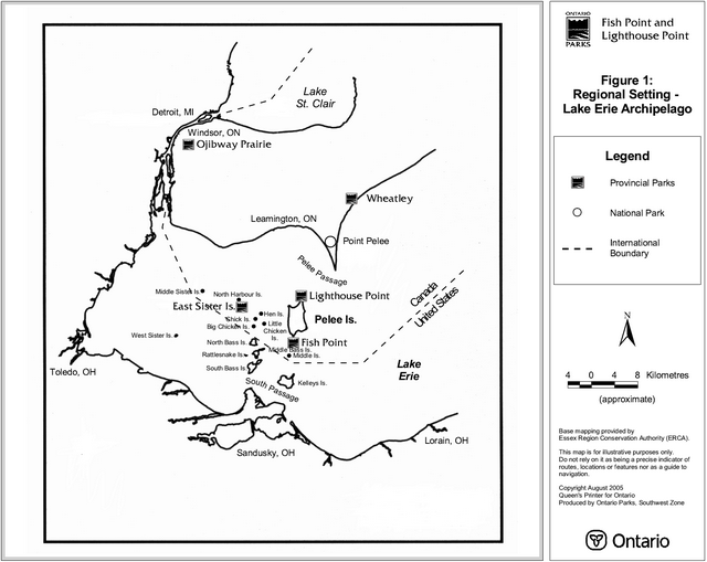
The Lake Erie Archipelago consists of a series of islands located mid-way between the Ontario and Ohio shorelines of Lake Erie (see Figure 1). The maritime influence of Lake Erie creates conditions favourable to a high diversity of plant and animal species, many of which are rare in Ontario and indeed Canada. The Canadian portion of the Lake Erie Archipelago includes Pelee Island, North Harbour Island, East Sister Island, Middle Sister Island, Middle Island, Hen Island, Little Chicken Island, Big Chicken Island, and Chick Island.
Pelee Island is located at the southernmost extent of Canada. This geographic location, combined with the coastal influences of Lake Erie, creates a climate that is generally warmer than the rest of the country. The mean annual temperature for the island is 9.8 Celsius which is approximately one degree higher than the rest of Essex County (Sanderson, 1980). Pelee Island has almost 200 frost-free days a year, which is 12 days longer than mainland Essex County and one of the longest in Canada. The prevailing winds are from the southwest, except in the winter months where winds originate from the west or northwest (Albrecht, 1988). On average the precipitation levels are lower than those found on the mainland. Thus drought conditions may occur in areas where soils are relatively thin. The mean annual precipitation is 847 millimetres, 80 millimetres of which falls as snow. Rain and snow averages are 64 and 16 days per year, respectively (Environment Canada, 1981).
Pelee Island is the largest of the Lake Erie Archipelago islands, and supports a number of the most ecologically significant areas in Canada. Two such areas are Fish Point and Lighthouse Point Provincial Nature Reserves, located at the southwest corner and northeast corners of Pelee Island, respectively. Fish Point encompasses 109.78 hectares. At Lighthouse Point, the province owns 96 hectares. The Essex Region Conservation Authority (ERCA) owns 9.6 hectares adjacent to the nature reserve, which was leased to the OMNR. This lease expired in April of 2005.
Provincial land acquisition associated with Fish Point Provincial Nature Reserve commenced in 1972. The Ontario government purchased the properties that now form Lighthouse Point Provincial Nature Reserve in 1973. In addition to the recognized life science features at this site, the purchase of these properties at that time was a viable economic alternative to repairing, replacing or upgrading a deteriorating dyke (built around 1890), which had protected farmland and an associated drainage system.
In 1983, the OMNR Chatham District Land Use Guidelines identified both Fish Point and Lighthouse Point as candidate nature reserve parks. Both sites were regulated under the Provincial Parks Act in 1985 (Ontario Regulation 45/85).
Figure 1: Regional Setting – Lake Erie Archipelago
Enlarge Figure 1: Regional Setting – Lake Erie Archipelago
Lighthouse Point is both an ecologically significant and culturally rich area. Its most prominent natural feature, Lake Henry, named after the Henry Nageleisen farm, characterizes this nature reserve. Lake Henry was formed during the winter of 1972-1973 when a combination of high lake levels and severe storms caused a breach in the barrier dyke that isolated a large wetland from Lake Erie. The breach of the dyke caused the inundation of the once protected farmland and the area reverted to a coastal wetland/marsh. Due to coastal processes and varying lake levels, the western shoreline of Lighthouse Point is constantly evolving. This allows for a variety of wildlife and vegetative communities to utilize this unique environment. A wide variety of birds utilize Lighthouse Point’s numerous habitat types especially during migration periods. The site is also home to various nationally, provincially and regionally rare and endangered floral and faunal species and communities.
From a cultural perspective, the site includes the remnants of the second oldest lighthouse on Lake Erie. Following its construction in 1834, the lighthouse guided thousands of vessels through the dangerous Pelee Passage. Due to the contributions and efforts of the Re-light the Lighthouse Committee, Pelee Island Heritage Centre, Township of Pelee, and Human Resources Development Canada, the lighthouse was restored as a historical landmark in 2000.
The most prominent feature of Fish Point (referred to as "Fishing Point" in the 1800s) is the sand spit located on the southern section of the reserve. Most of the spit has been colonized by forest vegetation. The study area’s southern locale and exposure to wind and lake currents has provided an ideal site for colonization of plant species from the south. These factors combined with unique environmental conditions have allowed Fish Point to have more provincially rare plants than any of the other major natural sites in the Erie Islands. These same conditions also control vegetative patterns on the spit. The sand spit is a dynamic feature that is constantly shifting and changing shape. This causes certain areas of the spit to be so exposed that vegetation is unable to survive. The beaches are littered with fallen trees uprooted by storms. Dry, unstable conditions typify the conditions found at Fish Point.
Activities or uses of adjacent lands and waters that may have a direct or indirect bearing on park and park-related values, and that are common to both nature reserves, consist of undeveloped private land, seasonal cottaging, rural residential, agriculture, sport hunting, sport fishing, and commercial fishing. Potential adjacent activities include oil and gas exploration. Adjacent to Lighthouse Point there is a limestone quarry fronting on Harris Garno Road, a small municipal parking area off East Shore Road and the adjoining natural lands leased from ERCA.
There has been a marked increase in tourism on Pelee Island starting with expanded ferry service in 1992, and given provincial, national and global trends in tourism and ecotourism, these increases can be expected to continue. Fish Point and Lighthouse Point Provincial Nature Reserves, together with the Stone Road Alvar Nature Reserve (Ontario Nature), Stone Road Alvar Conservation Area (ERCA), and the Shaughnessy Cohen Memorial Savanna (Essex Field Naturalists), figure prominently in ecotourism on Pelee Island and the surrounding region. The sites attract significant numbers of birders, photographers, tourists, ecologists, and researchers. Annual visitation to the nature reserves is estimated at 7,500 for Fish Point and 9,500 for Lighthouse Point.
Other provincial parks located in the general region include East Sister Island Provincial Nature Reserve, Ojibway Prairie Provincial Nature Reserve, and Wheatley Provincial Park. Point Pelee National Park faces Lighthouse Point across the Pelee Passage.
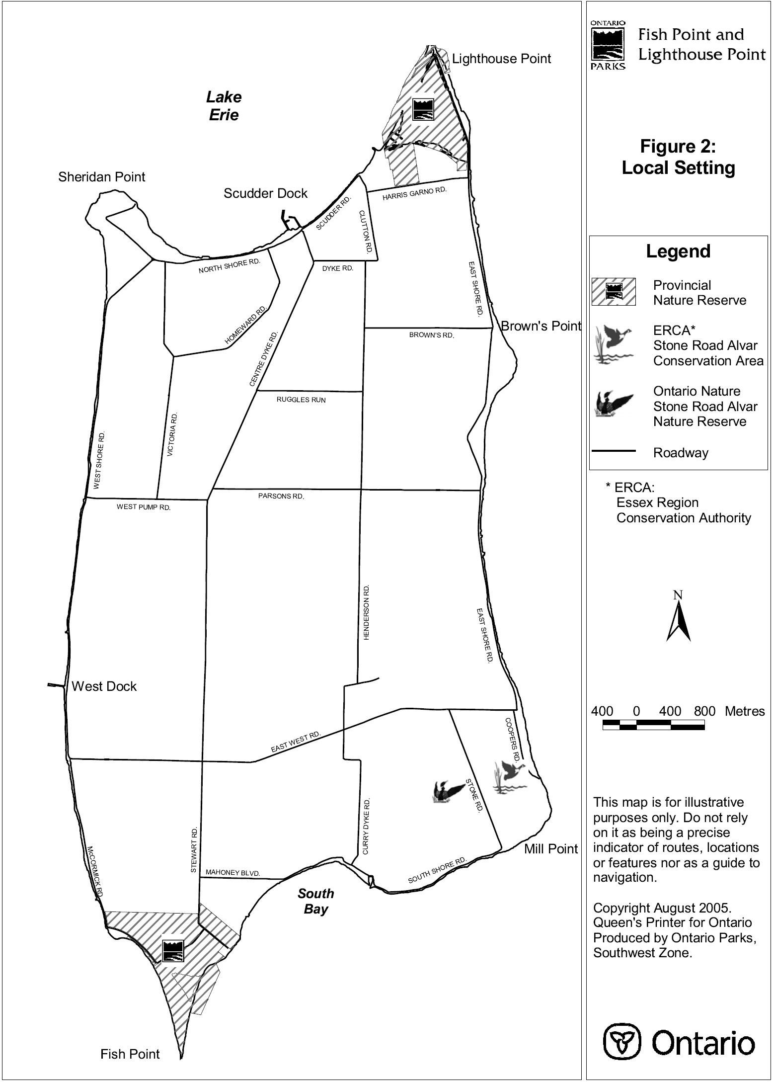
This document has been prepared through a cooperative planning partnership involving the Township of Pelee, Essex Region Conservation Authority, Ontario Nature (formerly the Federation of Ontario Naturalists) and Ontario Parks. The Pelee Island natural areas that were the subject of this planning process included the Stone Road Alvar Nature Reserve, Stone Road Alvar Conservation Area, and Fish Point and Lighthouse Point Provincial Nature Reserves (see Figure 2).
Nothing in this document shall be construed so as to derogate from, or abrogate any Aboriginal, treaty, constitutional or any other First Nation rights or the rights, powers or privileges of the Province of Ontario. Nothing in this document shall be construed as an acknowledgement of any rights asserted or the validity of any claim asserted by First Nations.
Figure 2: Local Setting

Enlarge Figure 2: Local Setting
2.0 Classification
All provincial parks in Ontario fall into one of six classes: wilderness, nature reserve, historical, natural environment, waterway or recreation.
Fish Point and Lighthouse Point are both nature reserve class provincial parks and have been planned, zoned, and managed in accordance with the policies for this class of park:
Nature reserves are areas selected to represent the distinctive natural habitats and landforms of the province. They are protected for educational purposes, as gene pools for research to benefit present and future generations and for their intrinsic values to society.
Both sites are designated as provincially significant Life Science Areas of Natural and Scientific Interest (ANSI). The features are representative of the ecology of the Erie Island Archipelago and offer unique opportunities to study the principles of island biogeography of organisms approaching their northern range limit. The majority of vegetation species and communities found within the nature reserves are representative of the Carolinian forest region.
3.0 Goal
The goal for Fish Point and Lighthouse Point Provincial Nature Reserves is to preserve the parks' environments, which contain provincially significant biological features.
Fish Point and Lighthouse Point Provincial Nature Reserves will be managed for the people of Ontario as nature reserves, protected from the impacts of human activity, now and in the future. The Provincial Parks Act, Ontario Provincial Parks Policy and Ontario Provincial Parks: Planning and Management Policies govern the two nature reserves. Both sites achieve targets for the provincial parks system by protecting provincially significant life science features as identified in the Chatham District Land Use Guidelines.
4.0 Objectives
There are four established objectives for the Ontario provincial parks system: protection, recreation, heritage appreciation and tourism. As nature reserve class provincial parks, Fish Point and Lighthouse Point contribute primarily to the protection and heritage appreciation objectives.
4.1 Protection objective
The Nature Reserves' protection objective is to protect provincially significant, special and representative life science, earth science and cultural heritage features.
Park management plans apply only to the area within the regulated boundary of the park. Within the park boundary, the protection objective will be achieved through appropriate zoning, control of land use and activities, education, and monitoring of ecological impacts. Appropriate mitigation of potential impacts will ensure continued protection of significant features. Management plans may consider potential impacts that activities occurring in adjacent areas may have on park values and features. In addition, management plans may consider the impacts of parks activities and land uses on adjacent areas.
Ontario’s parks play an important role in representing and conserving the diversity of Ontario’s natural features and ecosystems, across the broader landscape. Protected areas include some of the best representative examples of earth science, cultural heritage and life science features within ecologically defined regions. Ontario’s 71 ecodistricts are defined based on broad similarities in land formations and predominant vegetation.
4.1.1 Life science
Both Fish Point and Lighthouse Point are located within Ecodistrict 7E-1.
Fish Point
Fish Point Provincial Nature Reserve contains 15 national species at risk, as determined by the Committee on the Status of Endangered Wildlife in Canada (COSEWIC). Four of these species are endangered, including the Eastern Prickly Pear Cactus, Red Mulberry, Lake Erie Water Snake and Smallmouth Salamander. Another two have been classified as threatened, including American Water-willow and Eastern Fox Snake. The remaining seven species are considered to be of Special Concern and include Wild Hyacinth, Blue Ash, Dwarf Hackberry, Climbing Prairie Rose, Hop Tree, Swamp Rose- mallow, and Yellow-breasted Chat. Two additional nationally endangered species could be found at Fish Point in the past, but may now be locally extirpated. Blue Racers were last confirmed at Fish Point in 1971. Blanchard’s Cricket Frog was last reported at Fish Point in the mid-1980's. Since their last confirmed sightings, searches for Blue Racers and Blanchard’s Cricket Frogs at Fish Point have been unsuccessful.
In addition, 52 provincially rare and 25 regionally rare plant species have been recorded at Fish Point. Of those provincially rare species, 11 are extremely rare (S1), 26 are very rare (S2), and 15 are rare (S3). These numbers exclude the species at risk listed above. S-ranks are sub-national rankings for provincial rarity assigned by the OMNR Natural Heritage Information Centre (NHIC).
The Juniper Dune Shrubland type and the Dry Fresh Hackberry Forest type at Fish Point are very rare vegetation communities in Ontario. The Sea Rocket Sand Beach type and Dry Black Oak Deciduous Forest type are rare to very rare in Ontario.
Lighthouse Point
Based on the most recent species information, Lighthouse Point Provincial Nature Reserve presently contains eleven nationally rare floral and faunal species as determined by COSEWIC. The Blue Racer, Lake Erie Water Snake, Smallmouth Salamander and Spotted Turtle are considered endangered. Threatened species consist of American Water-willow, Eastern Fox Snake and Eastern Spiny Softshell Turtle. The remaining four species are classified as special concern - Blue Ash, Hop Tree, Prairie Rose and Swamp Rose-mallow.
An additional 31 provincially rare and 19 regionally rare plant species are found at Lighthouse Point. Of those provincially rare species, 7 are extremely rare (S1), 16 are very rare (S2), and 8 are rare (S3). These numbers exclude the species at risk listed above.
Lighthouse Point contains two of Ontario’s extremely rare vegetation types: Cottonwood Dune Savanna type and Chinquapin Oak Nodding Onion Treed Alvar Grassland type.
4.1.2 Earth science
The southern portion of Fish Point is essentially a migrating sand spit formed by the convergence of two lake currents on the southwestern portion of Pelee Island. It is a distinct feature reminiscent of Point Pelee, located on the Essex mainland. Conditions along the western shore of the spit are very dry, while the eastern shore has both dry conditions and an open water wetland (Fox Pond). Low stable sand dunes are the dominant landform feature on top of which there are growths of Hackberry and Black Oak forests.
The dominate foreland of Lighthouse Point is controlled by middle Devonian limestone bedrock of the Dundee formation. Overlying the bedrock is a shortened sand spit that was shaped by the meeting of two Lake Erie currents on the north shore of Pelee Island. The blunt configuration, which is atypical of other Great Lakes' spits, has been caused by a strong west to east current that travels through the Pelee Passage. Littoral materials (gravel, sand and shell fragments) then come under the influence of a southerly current flowing from Point Pelee and along the east shore of the island. As a result, sandbars line the east and west shores of the point. Starting in the mid-1800s dykes were constructed to allow for the conversion of low-lying wetlands (once referred to as Light House Marsh) to agricultural lands. This area was actively farmed until 1972, when high lake levels and severe storms caused a breach in the southwest corner of the dyke system. This resulted in flooding of the once protected farmland, and the present day Lake Henry was formed. Erosion of the remaining barriers on the west shore has reduced Lake Henry to a shallow coastal wetland of Lake Erie.
4.1.3 Cultural resources
The second oldest lighthouse on Lake Erie is located at Lighthouse Point. Pelee Lighthouse, erected in 1833, was constructed to aid ships passing through the treacherous Pelee Passage and is considered a landmark of historical significance. The lighthouse was completely restored through a project coordinated by the Pelee Island Heritage Centre in 2000. In association with the lighthouse, the primary historical theme will be "Transportation and the Integration of Economies", with a historical theme segment of the "Lower Lakes Internal Shipping 1830s to early 1900s".
Located just off the northeast shore of Lighthouse Point is the wreck of the side paddle-wheeled steamer, The America, which sank in 1854. A recent sonar sidescan revealed that very little remains of the 76-metre shipwreck. Other marine heritage resources, as yet undiscovered, may also exist in the vicinity of both Lighthouse Point and Fish Point.
Archaeological evidence suggests that First Nations once used the Fish Point area for camping associated with fishing and chert quarrying.
4.2 Heritage appreciation objective
The nature reserves' heritage appreciation objective is to provide opportunities for unstructured individual exploration and appreciation of life science, earth science and cultural heritage of Fish Point and Lighthouse Point.
Individual exploration and appreciation will be encouraged, where compatible with protection of life and earth science features. Self-guided interpretive trails will assist individuals in exploring and appreciating the nature reserves.
Interpretive and educational programmes will be developed, compatible with and complementary to protection of life science, earth science and cultural features. Visitors to the nature reserves will gain an appreciation for the significance and protection of the natural values on site through the use of interpretive panels and a leaflet.
5.0 Boundary
The nature reserves' existing boundaries are shown in Figures 3 and 4. The areas regulated under the Provincial Parks Act for Fish Point and Lighthouse Point are 109.78 hectares and 96 hectares, respectively. Lake Erie, municipal roads, and private property bound both Fish Point and Lighthouse Point. The boundary will be posted and, should the need arise, fencing and gating may be installed to control access.
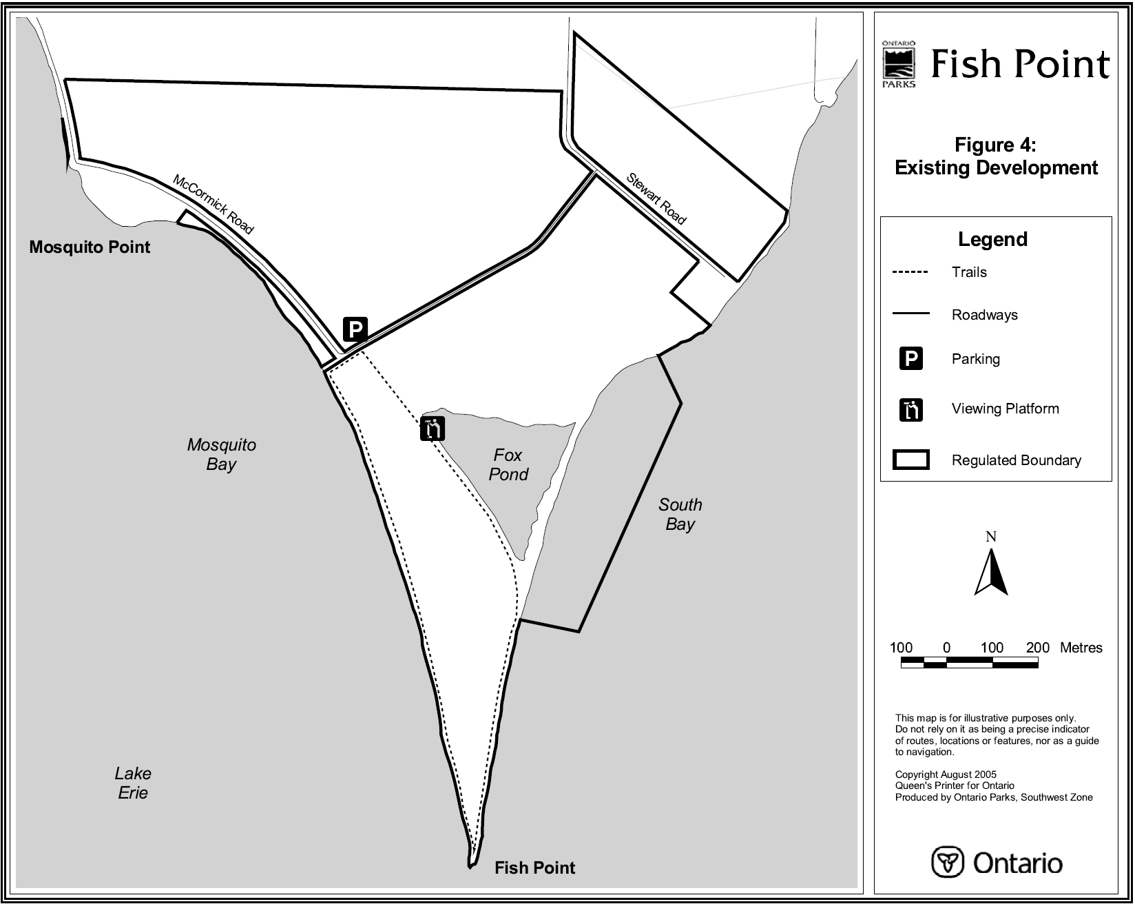
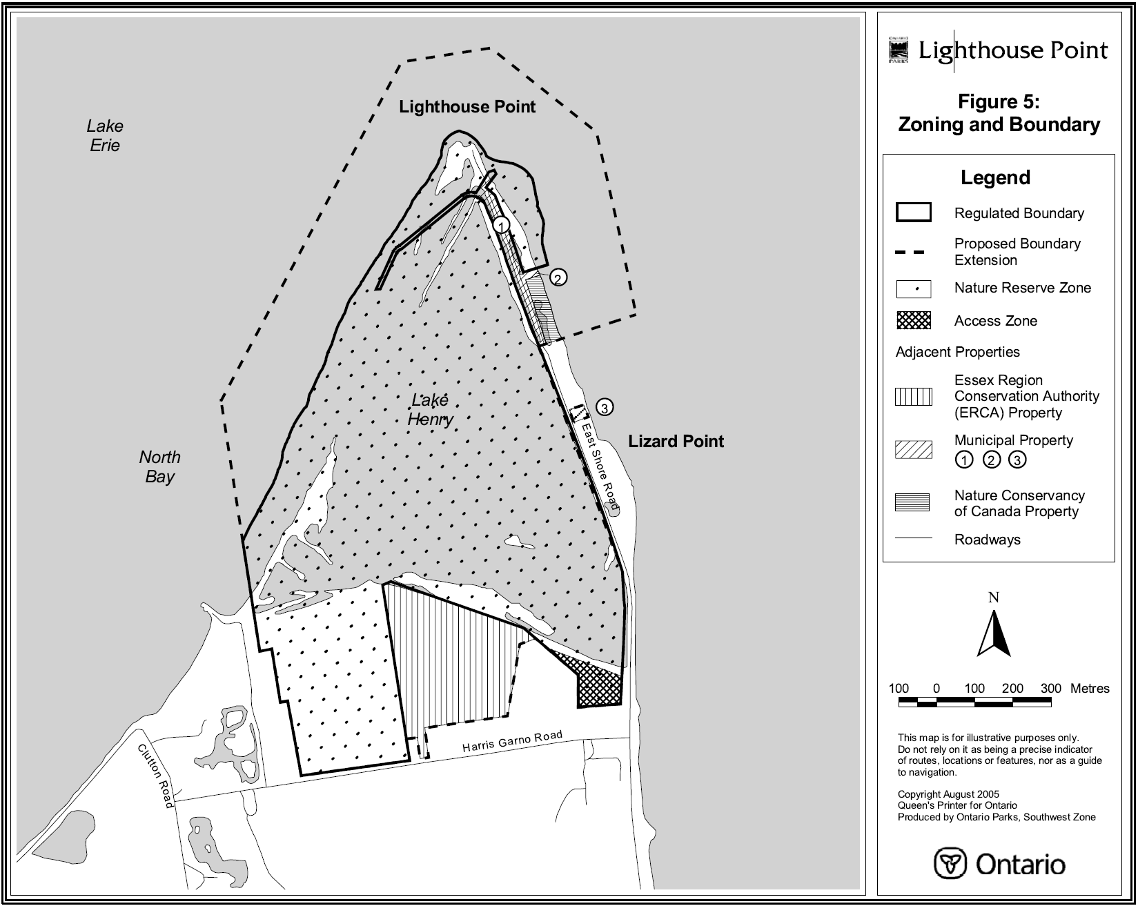
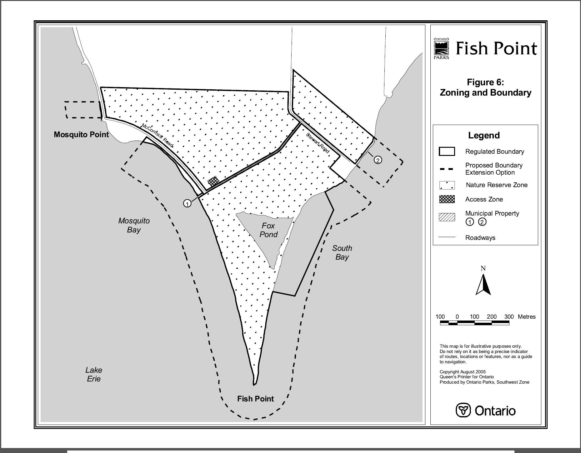
It is common for provincial parks fronting on lakes or rivers to have the regulated boundary extend out into the water. The purpose of this water boundary is to enhance the protection of natural and cultural marine features. Fish Point presently has a partial water boundary off its easterly shore that coincides with an acquired water lot. The adjacent lakebed is otherwise under the jurisdiction of the Crown. A boundary amendment will be pursued to extend the regulated limit of both provincial nature reserves approximately 200 metres from the water’s edge out into Lake Erie (see Figures 5 and 6).
Ontario Parks will discuss with ERCA the future status of the 9.6 hectare authority property adjacent to Lighthouse Point Provincial Nature Reserve (see Figure 5). In principle, Ontario Parks will consider a range of options including:
- acquiring property title from ERCA
- negotiating a land exchange with ERCA for a portion of Fish Point Provincial Nature Reserve or other suitable provincial lands
- entering into a long-term lease for the property from ERCA (e.g., 99 years) and regulating the parcel as part of the nature reserve; or
- not renewing the lease such that ERCA retains management responsibility for the property
A parcel of land (approximately two hectares) held by The Nature Conservancy of Canada may be leased or transferred to the Province of Ontario as an addition to Lighthouse Point Provincial Nature Reserve (see Figure 5).
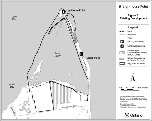
Figure 3: Existing Development (Lighthouse Point)
Enlarge Figure 3: Existing Development (Lighthouse Point)
Figure 4: Existing Development (Fish Point)
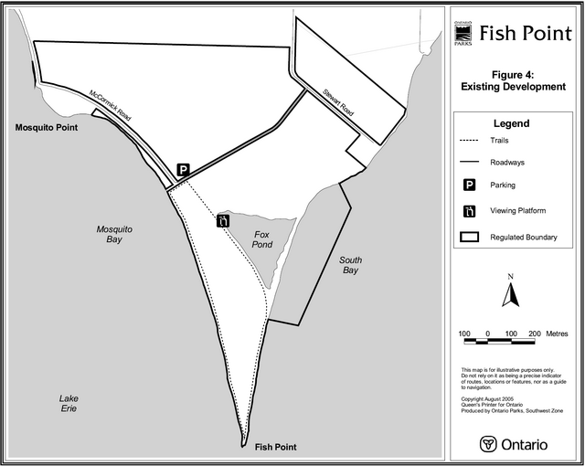
Enlarge Figure 4: Existing Development (Fish Point)
Figure 5: Zoning and Boundary

Enlarge Figure 5: Zoning and Boundary
Figure 6: Zoning and Boundary
Enlarge Figure 6: Zoning and Boundary
Ontario Parks may either negotiate a property purchase or land exchange with the Township of Pelee Island for municipal lands located within or adjacent to Lighthouse Point Provincial Nature Reserve. A portion of an open field within the nature reserve could be declared surplus to the province’s needs and exchanged for municipal properties (e.g., parking area on East Shore Road, road allowances, drains, etc.) located within the proposed nature reserve boundary (see Figure 5). Another option would be to exchange a portion of the open field for adjacent private land that would better contribute to the protection of natural values.
Adjacent lands may be considered for acquisition in order to protect and buffer significant natural features and resources, subject to the availability of funding and land acquisition priorities. Acquired properties will be regulated as part of each respective nature reserve.
6.0 Zoning
Lands and waters contained within Fish Point and Lighthouse Point Provincial Nature Reserves are zoned in accordance with their environmental qualities and required protection. The two zoning categories designated for the nature reserves (nature reserve zone and access zone) are based on the Ontario Provincial Parks: Planning and Management Policies. The zones differentiate the degree of development, uses and management practices permitted in each (see Figures 5 and 6).
6.1 Nature reserve zone
This zone includes the significant life science, earth science and cultural features of the nature reserves. In Fish Point and Lighthouse Point the area of nature reserve zones are 109.78 hectares and 96 hectares in size, respectively (see Figures 5 and 6). Any acquired lands regulated as part of either nature reserve will be zoned as nature reserve.
Development normally would be restricted to a self-guided interpretive trail with interpretive panels. However, the option is open for the development of an artificial barrier between Lake Henry and Lake Erie in Lighthouse Point Provincial Nature Reserve subject to the conditions listed in Section 9.4.
6.2 Access zone
Small staging areas will provide parking for a limited number of vehicles, necessary signs and an interpretive panel(s) (refer to Figures 5 and 6). In Fish Point and Lighthouse Point, the proposed access zones are 0.5 hectares and 1.0 hectare, respectively.
7.0 Natural Heritage Stewardship policies
Fish Point and Lighthouse Point Provincial Nature Reserves will be managed in accordance with the policies set out in the Ontario Provincial Parks: Planning and Management Policies.
Natural heritage stewardship initiatives may be accomplished through partnerships and sponsorships.
All management prescriptions for Fish Point and Lighthouse Point Provincial Nature Reserves will have regard for the Endangered Species Act, which protects all provincially designated endangered species and their habitats from any negative interference. Within these two nature reserves this legislation protects the following species and their habitats: Eastern Prickly Pear Cactus, Blue Racer, Lake Erie Water Snake and Blanchard’s Cricket Frog. Other species may become subject to the Act, or its successors, over time.
All natural heritage stewardship activities will be undertaken in accordance with requirements under the Provincial Parks Act and Environmental Assessment Act.
An adaptive management approach will be applied to resource management activities within the two nature reserves. Adaptive management allows for continual modification of planning and management strategies as better information becomes available. Modifications are based on new scientific findings and experiences.
7.1 Landform and water
The Township of Pelee will be permitted access to the dyke and drain south of Lake Henry at Lighthouse Point for the purpose of monitoring, maintaining, repairing or undertaking other necessary works under the Drainage Act. A proposal for an artificial barrier between Lake Henry and Lake Erie is addressed in Section 9.4.
The potential exists for oil and gas exploration to occur in the future adjacent to either Fish Point or Lighthouse Point Provincial Nature Reserves.
Landform and water management prescriptions will be addressed in greater detail prior to implementation.
7.2 Vegetation
Vegetation management priorities will include:
- protective management of rare species, including species at risk
- rehabilitation of plant populations and habitats
- maintenance of certain plant communities
- control of alien flora and fauna
- protection of plant communities from adverse impacts such as trampling and picking
- control of Poison Ivy adjacent to trails and parking areas
- provision of opportunities for viewing and interpreting plants
To maintain or enhance habitat for at-risk vegetation, some active management activities may be used including:
- replication of natural disturbance such as fire or wind disturbance through prescribed burns, and/or mechanical cutting of vegetation
- hand pollination, seed collection and/or propagation
- supplementary planting of seedlings or mature plants of similar genetic composition to the individuals presently or formerly found within the nature reserves
- construction of fenced exclosures to prevent predation on plants; and
- re-routing of trails to prevent damage from trampling
Non-native plant species will not be deliberately introduced. Where they are already established, and threaten park values, a program will be developed for their eradication.
The occurrence of insects and diseases native to the forest region in which the nature reserves are situated is recognized as an integral component of the ecology of the nature reserves. Insect infestations and diseases will normally be allowed to progress naturally. If such outbreaks threaten values for which the nature reserves were selected, they will be controlled where feasible, using biological controls whenever possible.
Insects and diseases not native to the nature reserves' forest region will be controlled where feasible. When control is undertaken, it will be directed as narrowly as possible to the specific insect or disease, so as to have minimal effects on the balance of either nature reserve’s environment. Biological controls will be used whenever possible.
Except where there is threat to public safety, dead trees will be left standing to serve as important homes for resident cavity nesting birds and mammals. Dead tree falls and tip-ups will also be left in place to serve as important sites for mosses and fungi, germination areas for tree species requiring rotting wood as a rooting medium, and moist shelters for small mammals, reptiles, amphibians and a variety of insects.
Vegetation management prescriptions will be addressed in greater detail in a resource stewardship plan prior to implementation.
7.3 Fisheries and wildlife
Fisheries and wildlife management priorities will include:
- protective management of rare species, including species at risk
- protection and management of wildlife habitat such as nesting sites, feeding grounds, staging areas
- control of nuisance fauna
- re-introduction of extirpated species subject to the provisions of recovery plans
- provision of opportunities for viewing and interpreting wildlife and associated habitat
Habitat for species at risk may be enhanced through the installation of artificial habitat features such as nesting boxes, hibernacula, hot rocks, etc., within the boundaries of the nature reserves.
Extirpated native species may be re-introduced subject to the provisions of recovery plans, and existing populations replenished, if this is biologically feasible and acceptable, and if it is desirable in terms of perpetuating values for which each nature reserve was established.
Non-native species will not deliberately be introduced. Where they are already established, a management program for their eradication may be developed, if it is practical and feasible for the perpetuation of the values for which the parks were established.
Hunting and commercial trapping will not be permitted in the nature reserves. Sport fishing is permitted. Commercial fishing is permitted within the Lake Erie portions of both the Fish Point and Lighthouse Point regulated park water boundaries.
Animal populations may be controlled when essential to protect human health and safety, the health of the species outside the nature reserves, or the values for which the nature reserves were established. When control is required, techniques will be used that have minimal effects on the balance of either nature reserve’s resource base. Any wildlife population reductions or trapping for management purposes will be carried out under the supervision of, or directly by, Ontario Parks.
Fisheries and wildlife management prescriptions will be addressed in greater detail prior to implementation.
7.4 Cultural resources
Ontario Parks will develop a memorandum of understanding with the Pelee Island Heritage Centre and/or other partners for the long-term maintenance and upkeep of the lighthouse at Lighthouse Point.
Historic materials or artifacts associated with shipwrecks that wash ashore will be reported to the Ministry of Culture. For their protection, moveable artifacts may be transferred on loan to the Pelee Island Heritage Centre for cataloguing and storage or display. Larger materials will remain on site or dealt with in an appropriate manner.
In 1987, archaeologist William A. Fox recommended that the entire Fish Point should be surveyed, particularly those areas impacted by high lake level erosion. A future archaeological assessment may be undertaken in the nature reserve. Ontario Parks will consult with local First Nations regarding any proposed archaeological assessments or the discovery of new Aboriginal sites or artifacts in either nature reserve.
7.5 Recreational resources
The sandy beaches at both Fish Point and Lighthouse Point will sustain some recreational activities such as swimming and sunbathing. Anthropogenic debris will be periodically cleared from the shorelines of the nature reserves and disposed of in an appropriate manner.
Self-interpretive walking trails exist or will be expanded in both nature reserves, including the possible development of a boardwalk into Lake Henry to facilitate wildlife viewing. Scenic vistas and wildlife viewing opportunities will also be afforded from viewing platforms at key locations around the periphery of Lake Henry and Fox Pond.
8.0 Operations policies
Operations policies for Fish Point and Lighthouse Point will be incorporated into the Wheatley Provincial Park operations plan. The plan will provide park staff, volunteers and partners with the necessary direction to effectively manage the nature reserves. In addition to addressing the operations policies that follow, the plan will include such topics as budget, staffing, maintenance schedules, enforcement, and emergency services. The provisions of the plan will be consistent with the approved Ontario Provincial Parks Minimum Operating Standards and will be reviewed annually and updated as required.
8.1 Natural heritage education
Services for visitors, including school groups, will be primarily oriented towards self-guided use. The three components of the natural heritage education program are information, interpretation and recreation.
Ontario Parks will cooperate with the Pelee Island Heritage Centre, the Township of Pelee, ERCA, Ontario Nature and/or other partners in terms of natural heritage education related to natural areas on Pelee Island. One initiative is the design and production of an interpretive brochure addressing all the natural areas on Pelee Island.
8.1.1 Information
Objectives for the information component of the natural heritage education program include:
- informing visitors about the nature reserves, their features, facilities and management
- instilling in visitors a sense of respect for the parks' environments and natural values
- describing the role of Ontario Parks, OMNR and partners
- providing a means for visitors, local residents, and interest groups to communicate with Ontario Parks regarding park management
- providing information about the provincial system of nature reserves
The preceding policies will be achieved through a combination of an interpretive leaflet, interpretive panels, informal meetings with the planning partners and interest groups, and personal contacts with park visitors.
8.1.2 Interpretation
Fish Point and Lighthouse Point contain several significant and interesting natural or cultural heritage features worthy of interpretation. Natural heritage education facilities and services will be very limited in scope, focusing on self-guided interpretive trails and viewing platforms in conjunction with interpretive panels and leaflets.
8.1.3 Recreation
Hiking will occur on self-guided interpretive trails. Swimming is permitted in the nature reserves. Recreation programming will not be offered.
8.2 Research
Scientific research by qualified individuals contributing to the knowledge of natural and cultural history and to environmental management will be encouraged. All research projects will require the approval of Ontario Parks and must meet all requirements under applicable provincial and federal legislation. Approved research activities must be consistent with Ontario Parks' Research and Information Strategy.
8.3 Recreation management
Hiking will be confined to designated trails. Swimming and sunbathing are permitted in the nature reserves, however, a dangerous undertow warning is posted at Fish Point. Recreational boating occurs in the vicinity of both nature reserves.
Prohibited activities include camping, hunting and the operation of off-road vehicles.
9.0 Development policies
9.1 Parking
The existing parking area at Fish Point will be monitored and may be expanded modestly to accommodate additional vehicles (maximum of 15 vehicles) if required.
At Lighthouse Point, a main parking area (maximum of 25 vehicles) will be developed at the intersection of East Shore Road and the dyke at the southeast corner of Lake Henry (see Figure 7).
Bicycle racks will be installed at all parking areas.
Figure 7: Development Options

Enlarge Figure 7: Development Options
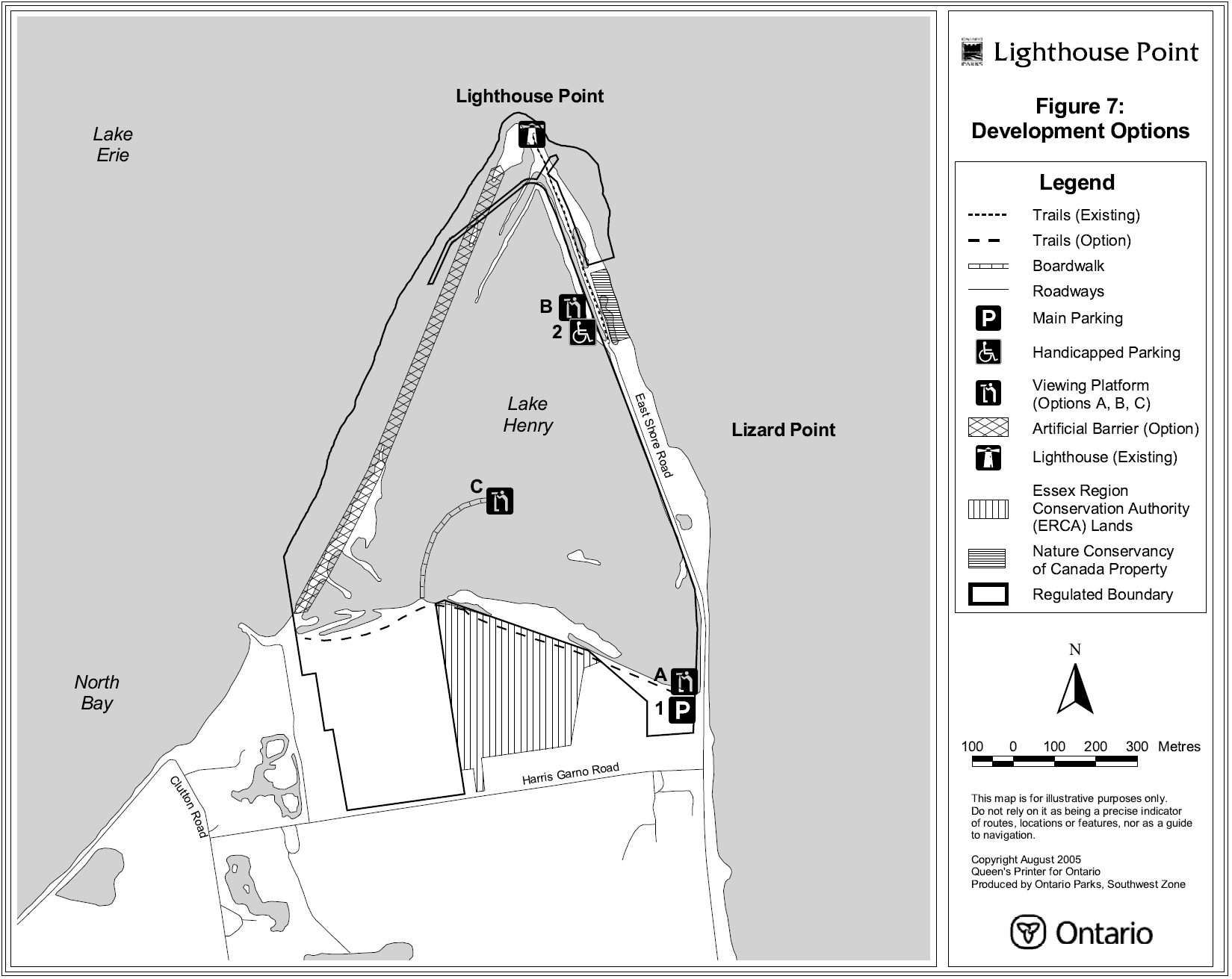
9.2 Trails
At Lighthouse Point, the trail from the north end of East Shore Road provides access to the lighthouse. Limestone screenings have been previously laid down to provide a defined and drier walking surface. A boardwalk may be developed to provide handicapped access and to reduce the impacts on adjacent ground vegetation.
An overgrown trail along the dyke south of Lake Henry will be brushed open. From about the mid-point of this trail, a boardwalk may be constructed out into Lake Henry.
9.3 Interpretive facilities
Interpretive facilities will be modest, consisting of interpretive panels at the trailhead and at key locations along trails in both nature reserves.
To facilitate wildlife viewing, two viewing platforms may be developed off the East Shore Road overlooking Lake Henry at Lighthouse Point. A third viewing platform may also be constructed in the wetland at the end of the proposed boardwalk extending out from the south dyke (see Figure 7).
9.4 Lake Henry artificial barrier
The dyke between Lake Henry and Lake Erie failed during the winter of 1972/73. The area inundated by the waters of Lake Erie had previously been drained and had been used for agricultural purposes. A decision was subsequently made by the provincial government to purchase the flooded properties rather than invest in the reconstruction of a dyke. Today there are differing opinions on the role played by Lake Henry, a provincially significant wetland.
One opinion, and the basis for a proposal discussed over a number of years, has been to construct an artificial barrier (e.g., dyke) to control water levels within Lake Henry. This is also based on the idea that Lake Henry is presently acting as a "sediment sink", retaining sand deposits, thereby fundamentally disrupting the transport of this material by currents along the island’s shoreline. It is thought that it may be beneficial to eliminate the deposition of sand into Lake Henry from a biological perspective since these sediments smother existing, productive organic substrates (i.e., the substance or nutrient on or in which an organism lives and grows) and wetland communities. Furthermore, a barrier may eliminate such foraging fish as carp, which have reduced aquatic biological productivity through uprooting wetland plants and increasing turbidity (i.e., the degree to which water is opaque or clouded due to suspended sediments). The proposal is also predicted to have some benefits for the local economy and tourism.
Ontario Parks has held the position that it would be preferable to allow the west barrier of Lighthouse Point to evolve under natural conditions. This option would direct long-term management towards some semblance of pre-settlement coastal marsh conditions. In addition to Fish Point, this option would result in one of the only other remaining non-dyked or hardened portions of Pelee Island shoreline. Based on past studies and opinions rendered by various consultants and experts, Ontario Parks is not convinced that an artificial barrier between Lake Henry and Lake Erie at Lighthouse Point is justified from either a coastal geomorphological or ecological perspective. There is doubt that the perceived benefits from developing an artificial barrier and establishing a wetland with controlled water levels outweigh the costs of such a project.
Nevertheless, the proponent(s) may advance the proposal subject to the following conditions and understandings:
- The proponent will be responsible for meeting all requirements and costs associated with the conditions highlighted in numbered points 2, 3, and 4
- The proposal would be subject to an individual environmental assessment as prescribed under Part II of the Environmental Assessment Act and/or the Canadian Environmental Assessment Act (if the project is likely to affect fish or fish habitat, affect the quantity or quality of water available for fish or result in the destruction of fish). Ontario Parks determined this by screening the project under the Class Environmental Assessment for Provincial Parks and Conservation Reserves
- The proponent would be responsible for preparing the necessary documentation
- As part of the planning and environmental assessment process, the proposal would be reviewed and approved by the Department of Fisheries and Oceans (DFO). The proposal would be subject to any mitigation prescribed by DFO
- Ontario Parks would not contribute financially to the construction, mitigation or future maintenance of the artificial barrier. However, Ontario Parks is willing to reassess this position if a net ecological benefit is demonstrated by the environmental assessment
- If the project is approved, the proponent, or a suitable partner, could enter into a long-term agreement with Ontario Parks for the maintenance and repairs to the artificial barrier and avoidance of any adjacent harm or damage; and
- The outcome of the environmental assessment and associated public consultation process cannot be predetermined and approval for the concept cannot be guaranteed
9.5 Lighthouse
The historic lighthouse was restored through a partnership arrangement in 2000. No additional capital improvements are required.
In 1998, Ontario Parks authorized the placement of armour stone and shot rock around the base of the lighthouse to stabilize the structure against erosion during a period of high lake levels. Options for future protection of the lighthouse would include a carefully designed contiguous revetment, deployment of an offshore breakwater or submerged reef system, or relocation of the lighthouse to a more stable location on the island (Hall, 2002).
In cooperation with the Pelee Island Heritage Centre, an application will be submitted to the Ontario Heritage Foundation requesting that a provincial historic plaque be installed adjacent to the lighthouse. A suitable interpretive panel may also be developed to relate the history and significance of the lighthouse and shipwrecks in the Pelee Passage.
10.0 Implementation policies
In the implementation of the approved park management plan, Ontario Parks will explore opportunities for partnerships involving volunteers, school boards, non-government organizations or others. Implementation shall occur in an ecologically sustainable manner. All the requirements of the Environmental Assessment Act, Environmental Bill of Rights, Provincial Parks Act, Endangered Species Act and other pertinent legislation will be met.
Implementation and/or site plans will precede major development or natural heritage management initiatives, with an appropriate level of public consultation. Development projects and preparation of implementation plans will be contingent upon the availability of funding and unforeseeable changes in priorities or park policy.
In addition to the list of management activities described in Section 7, implementation priorities will also include:
- installation of fencing and gates as required
- installation of interpretive panels
- posting of boundary markers
- expansion and improvement of the self-guided interpretive trails at Lighthouse Point
- development of viewing platforms at Lighthouse Point
- development of parking facilities at Lighthouse Point; and
- measures to protect the lighthouse at Lighthouse Point
11.0 Summary of public consultation
Public consultation was a very important component of the park management planning process. The following are the four stages of the process:
- Stage 1 - Terms of Reference and Initial Invitation to Participate
- Stage 2 - Background Information – Issues and Options Report
- Stage 3 - Preliminary Park Management Plan
- Stage 4 - Approved Park Management Plan
Stage 1 consisted of a 45-day opportunity for the public to inspect the approved Terms of Reference for the park management planning process, which commenced in the December 2000. A policy proposal notice was posted on the EBR Environmental Registry and a paid advertisement was inserted in local and regional newspapers. An initial invitation to participate was mailed out to 635 local residents and interest groups and a public notice was posted on site. Open houses were held on February 22, 2001, in Kingsville, and February 23, 2001, on Pelee Island with 43 and 40 persons attending, respectively.
Stage 2 focused on providing a 45-day opportunity for the public to review the Fish Point and Lighthouse Point Provincial Nature Reserves Background Information – Issues and Options report. The document and a notice were mailed to 630 local residents and interest groups in June 2001. A paid advertisement was inserted in local and regional newspapers. Open houses were held on Pelee Island on July 7, 2001, and in Kingsville on July 10, 2001, with 18 and 6 persons attending, respectively.
Stage 3 involved a 45-day opportunity for the public to review the Fish Point and Lighthouse Point Preliminary Park Management Plan released in December 2002. Copies of the document were mailed directly to 751 individuals and interest groups. An updated policy proposal notice was posted on the EBR Environmental Registry and a paid advertisement was inserted in local and regional newspapers. Following public release of the document, open house meetings were held in Kingsville on December 10, 2002 and on Pelee Island on February 14, 2003, with 14 and 17 persons attending, respectively.
Based on stage 3 public consultation, the following notable changes were addressed in the final Fish Point and Lighthouse Point Park Management Plan:
- Section 1.0 has been amended to include a non-derogation statement relating to First Nations rights and claims
- Figure 5 was corrected to more accurately reflect the location of the Township of Pelee parking area on East Shore Road adjacent to Lighthouse Point Provincial Park. In addition, Figure 5 now identifies a parcel of land owned by The Nature Conservancy of Canada that is proposed to be added to the park
- In Figure 6, the proposed water boundary for Fish Point was adjusted so that it will not extend in front of private property adjacent to Stewart Road
- Section 7.2 now acknowledges the potential for oil and gas exploration adjacent to the nature reserves
- It was clarified in Section 7.3 that commercial fishing is permitted within the Lake Erie portions of both the Fish Point and Lighthouse Point regulated park water boundaries
In stage 4, a policy decision notice associated with the approved park management plan was posted on the EBR Environmental Registry and a paid advertisement was inserted in local and regional newspapers. A public notice was mailed to 633 local First Nations, local residents, interest groups and others in August 2005. This allowed interested participants a final 45-day opportunity to determine if their concerns had been adequately considered and addressed, and to initiate an appeal of the plan contents where appropriate.
Following its release, the approved Fish Point and Lighthouse Point Park Management Plan may be reviewed or amended to address changing issues or conditions. A review may involve a reassessment of all or part of the plan, including classification, zoning, goal, objectives and all resource management, operations and development policies, while an amendment may be considered to address specific issues or needs.
Ontario Parks will retain on file reference copies of the terms of reference, background information – issues and options report, preliminary park management plan, approved park management plan, and any subsequent plan reviews or amendments.
12.0 References
Albrecht, C.W. 1988. The Climate of Western Lake Erie’s Island Region.
BTS Consulting Engineers. 1999. Lighthouse Point Nature Reserve: Coastal Assessment to Support Future Management Plan Preparations. (Preliminary Draft).
Campbell, C.A. 1976. Resource Inventory Report – Preliminary Ecological Report on Lighthouse Point, Fish Point and East Sister Island Nature Reserves, Essex County, Ontario. Ministry of Natural Resources, Chatham District.
Chapman, L.J. and D.F. Putnam. The Physiography of Southern Ontario. Third Edition, Ontario Geological Survey, Special Volume 2, Toronto, 1984.
Crispin, S., L. Dupuis, K. Kavanagh, M. Woulfe, S. McKay-Kuja, and J. Prideaux. 1990. Carolinian Canada Data Centre Report to OMNR, Appendix 1: Element Lists for Ontario with Ranks and Official Status Designations. Nature Conservancy of Canada, Toronto.
Davidson-Arnott, R.G.D. and J. Doucette. 1996. Coastal Geomorphology and Assessment of Proposed Dyke Construction at Lighthouse Point Provincial Nature Reserve, Pelee Island. Department of Geography, University of Guelph.
Downhower, J.F. 1988. The Biogeography of the Island Region of Western Lake Erie. Ohio State University Press.
Environment Canada. 1981. Canadian Climate Normals 1951-1980: Temperature and precipitation in Ontario. Atmospheric Environment Service, Ottawa.
Essex Region Conservation Authority. 2000. Fish Point Provincial Nature Reserve Resource Management Discussion Document.. Essex.
Essex Region Conservation Authority. 2000. Lighthouse Point Provincial Nature Reserve Resource Management Discussion Document.. Essex.
Forbes, M., S. Hawco, and L. Fair. 1999. Ecosystem Plan for Pelee Island: 1999 Final Project Report to Canadian Wildlife Service, Ontario Division. Prepared by the Department of Biology, Herzberg Laboratories, Carlton University, Ottawa.
Gartner Lee Limited. 1996. Environmental Impact Study of Proposed Dike at Lighthouse Point, Pelee Island. Markham.
Hall, K. 2002. Opinion Regarding the Proposed Dyke Construction Project at Lighthouse Point Provincial Nature Reserve (Correspondence). HCCL, Kingston.
Kamstra, J., M. Oldham and P.A. Woodliffe. 1995 A Life Science Inventory and Evaluation of Six Natural Areas in the Erie Islands (Ontario): Fish Point Provincial Nature Reserve, Lighthouse Point Provincial Nature Reserve, Stone Road Complex, Middle Point, East Sister Island Provincial Nature Reserve, Middle Island. Chatham District, Ontario Ministry of Natural Resources.
Klinkenberg, R. 1984. Life Science Areas of Natural and Scientific Interest in Site District 7-1 – A Review and Assessment of significant Natural Areas in Site District 7-1. Ontario Ministry of Natural Resources, Southwestern Region, London.
McCormick-Hooper, M. 1967. Pelee Island Then and Now. Pelee Island.
Oldham, M.J. 1983b. An Update on the Status of the Blue Racer, Lake Erie Water Snake, Blanchard’s Cricket Frog and Smallmouth Salamander on Pelee Island, Ontario. Unpublished report for Wildlife Branch, Ontario Ministry of Natural Resources.
Oldham, M.J. 1983. Environmentally significant areas of the Essex Region. Essex Region Conservation Authority.
Oleszewski, W. 1998. Great Lakes Lighthouses - American & Canadian. Avery Color Studios, Gwinn, Michigan.
Ontario Ministry of Natural Resources. 1983. Chatham District Land Use Guidelines. Chatham.
Ontario Ministry of Natural Resources. 2005. Class Environmental Assessment for Provincial Parks and Conservation Reserves. Ontario Parks, Queen’s Printer for Ontario, Peterborough.
Ontario Ministry of Natural Resources. 2005. Our Sustainable Future – Ministry of Natural Resources Strategic Directions. Natural Resources Information Centre, Peterborough.
Ontario Ministry of Natural Resources. 1994. Environmental Assessment in Ontario Provincial Parks: An Interim Field Reference for Staff, Revised Edition. Corporate Policy and Planning Secretariat.
Ontario Ministry of Natural Resources. 1995. Environmental Bill of Rights Procedures Manual (Working Draft). Corporate Policy and Planning Secretariat.
Ontario Ministry of Natural Resources. 2001. Fish Point Provincial Nature Reserve and Lighthouse Point Provincial Nature Reserve Background Information - Issues and Options. Southwest Zone. Ontario Parks.
Ontario Ministry of Natural Resources. 1997. Ontario Parks' Research and Information Strategy. Planning and Research Section, Ontario Parks. Peterborough.
Ontario Ministry of Natural Resources. 1994. Ontario Provincial Park Management Planning Manual. Provincial Parks and Recreational Areas Branch. Toronto.
Ontario Ministry of Natural Resources. 1992. Ontario Provincial Parks Minimum Operating Standards. (Revised) Provincial Parks and Recreational Areas Branch. Toronto.
Ontario Ministry of Natural Resources. 1978. Ontario Provincial Parks: Planning and Management Policies. Outdoor Recreation, Toronto.
Ontario Ministry of Natural Resources. 1992. Ontario Provincial Parks: Planning and Management Policies, 1992 Update. Provincial Parks and Natural Heritage Policy Branch, Toronto.
Ontario Ministry of Natural Resources. 1990. Provincial Parks Act, Revised Statutes of Ontario.
Sanderson, M. 1980. The Climate of the Essex Region: Canada’s Southland. University of Windsor, Department of Geography.
Wachter, G. and Wachter, M. 2001. Erie Wrecks East. Corporate Impact, Avon Lake, Ohio.