Little Spring Lake Conservation Reserve Management Statement
This document provides policy direction for the protection, development and management of the Little Spring Lake Conservation Reserve and its resources.
Statement of Conservation Interest (C80)
Ministry of Natural Resources
Parry Sound District
Prepared with the assistance of:
Meteek & Company
Huntsville, Ontario
March, 2003
Approval statement
We are pleased to approve this Statement of Conservation Interest for Little Spring Lake Conservation Reserve (C80).
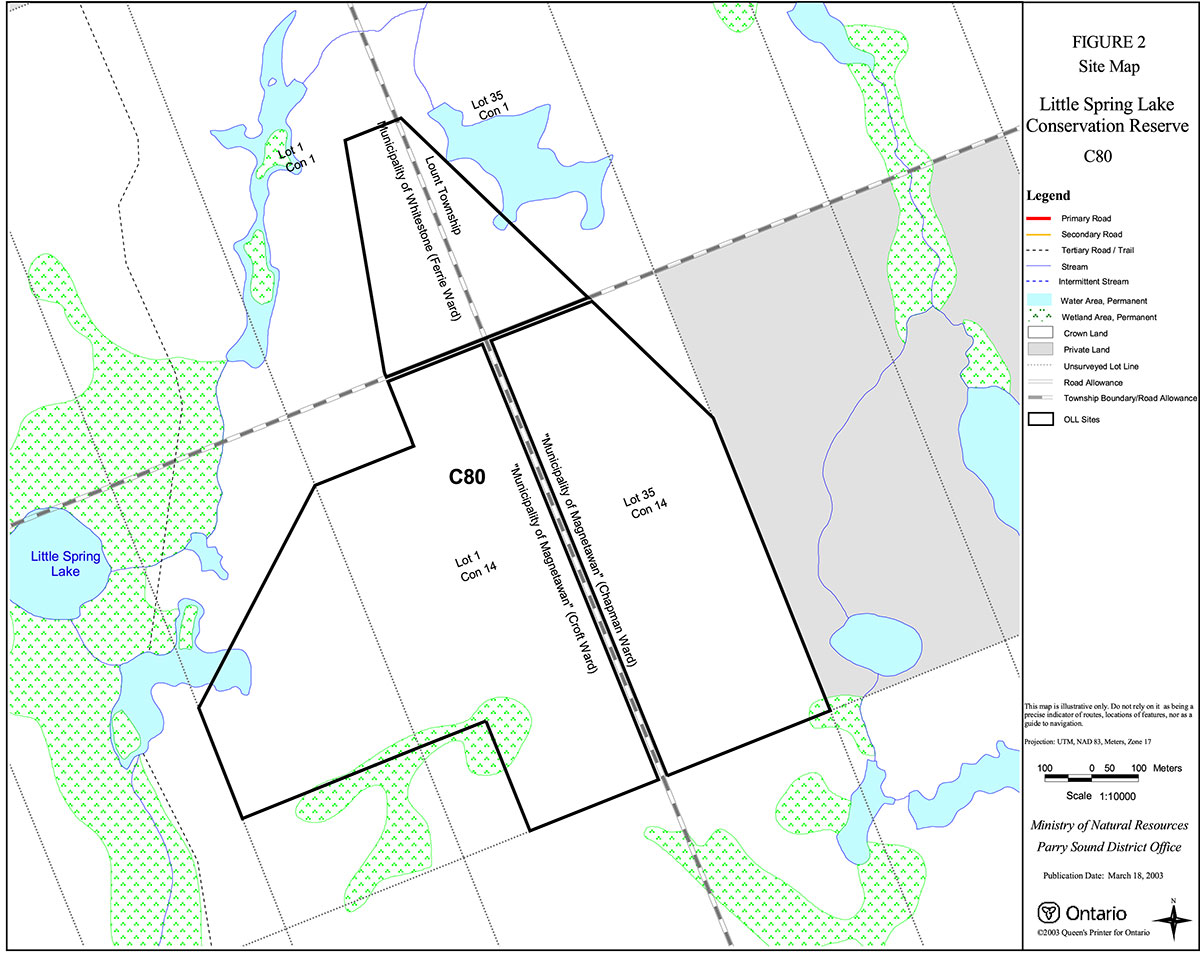
Little Spring Lake Conservation Reserve is a 106 hectare area of Crown land which lies at the junction of four geographic townships, Chapman, Croft, Ferrie and Lount, in the Territorial District of Parry Sound. Chapman and Croft Townships are within the Municipality of the Township of Magnetawan, while Ferrie Township is within the Municipality of Whitestone, and Lount Township is unincorporated. It is about 8 kilometres northwest of the village of Magnetawan, and one kilometre east of Little Spring Lake.
Little Spring Lake Conservation Reserve, located in Hill’s ecological Site District 5E -8, is dominated by very gently rolling landscape with tamarack forests and wetlands on bedrock with organic pockets and habitats providing ecological representation within the site district. The relative remoteness and lack of anthropogenic disturbance in and around the conservation reserve provides ideal habitats for a number of species of wildlife.
Little Spring Lake Conservation Reserve is one of 378 new protected areas approved through Ontario’s Living Legacy Land Use Strategy, aimed, in part, at completing Ontario’s system of parks and protected areas.
During the "Lands for Life" planning process, the public was widely consulted and provided valuable input into what became Ontario’s Living Legacy Land Use Strategy. Comments received during that time, and during consultation related to the formal Public Lands Act (Ontario Regulation 805/94) regulation of the boundaries of this conservation reserve, were generally supportive of the protection of this area. Stakeholders who provided comment during the earlier consultation for this site were subsequently consulted regarding the draft Statement of Conservation Interest and their comments were considered in the finalization of this document.
This Statement of Conservation Interest provides guidance for the management of the conservation reserve and provides the basis for the ongoing monitoring of activities. More detailed direction is not anticipated at this time. Should more complex resource management or conservation issues arise or significant facility development be considered, then a detailed Resource Management Plan will be prepared with full public consultation.
Little Spring Lake Conservation Reserve is managed under the direction of the District Manager of the Ministry of Natural Resources, Parry Sound District. The northern portion (in Ferrie and Lount townships) is under the supervision of the Bracebridge Area Supervisor, while the southern portion (in Chapman and Croft townships) is under the supervision of the Parry Sound Area Supervisor.
Approved by:
R. Griffiths
District Manager
Parry Sound District
Approved by:
Ron Running
Regional Director
Southcentral Region
1.0 Introduction
Ontario’s Living Legacy, the result of an extensive planning process that began in early 1997, culminated in the approval in July 1999 of a Land Use Strategy that identifies the intended strategic direction for Crown land, including the completion of Ontario’s system of parks and protected areas. This process, which included extensive public consultation, resulted in the recommendation for regulation of 378 new protected areas, including Little Spring Lake Conservation Reserve (C80).
Little Spring Lake Conservation Reserve is located in the Territorial District of Parry Sound, at the junction of the geographic townships of Chapman, Croft, Ferrie and Lount. It lies about 8 kilometres northwest of the village of Magnetawan. It lies about 5 kilometres west of the Nipissing Road, and the same distance north of Highway 520. Intervening land is low, wet and difficult to traverse, so access is very difficult to the conservation reserve. The result is an area that shows very little recent disturbance.
The conservation reserve, in Hill’s ecological Site District 5E -8, was identified during the Lands for Life selection process as an extensive wetland complex located in a relatively inaccessible area.
Conservation reserves are established under the authority of the Public Lands Act, Ontario Regulation 805/94. Little Spring Lake Conservation Reserve was established by Ontario Regulation 461/00, an amendment of the Public Lands Act, on August 10, 2000.
A Statement of Conservation Interest (SCI) is prepared under the authority of Procedural Guideline A – Resource Management Planning (PL. Procedure 3.03.05). The purpose of this SCI is to identify and describe the values of Little Spring Lake Conservation Reserve. The SCI also outlines the activities that currently occur within the conservation reserve and provides guidelines for the management of current and future activities in the context of protecting the natural, recreational and cultural values.
1.1 Background information:
| Name | Little Spring Lake Conservation Reserve (C80) |
|---|---|
| Site Region/District | Georgian Bay 5E-8 |
| OMNR Administrative Region/District/Area | Southcentral Region/Parry Sound District: Northern portion - Bracebridge Area; and Southern portion - Parry Sound Area |
| Total Area (ha.) | 106 hectares |
| Regulation Date | August 10, 2000 (O. Reg. 461/00) |
| First Nations | Robinson-Huron Treaty |
| OBM map sheets | 20 17 6000 50600 |
| Topographic Map | Magnetawan 31 E/12 |
| UTM co-ordinates | 17T 61800 506520 (Centroid) |
1.2 Representation
Earth science representation:
Mafic gneiss of the McLaren Island gneiss association of the Parry Sound Domain, Parry Sound Terrane in the Central Gneiss Belt of the Proterozoic Grenville Province.
The surficial topography is one of glacially deposited sand, probably of glaciofluvial origin.
Life science representation:
- Open wetland with treed bog/fen surrounded by conifer forest
Cultural resources representation:
Neither detailed cultural research nor inventory has been carried out for this conservation reserve. However, the presence of old stumps indicates that this area was logged from late 19th century, to about 40 years ago. Otherwise there is little other evidence of historic use or development. Recent regional evaluation (OMNR 2003) shows that this conservation reserve contains areas that have a high potential for cultural heritage sites.
Recreational opportunities:
A recreational inventory report was prepared for this site based on existing knowledge of MNR staff. No additional specific studies have been done. There is little evidence of recreational activity within the conservation reserve, although adjacent areas are hunted.
1.3 Survey work
| Survey Level | Earth Science | Life Science | Cultural | Recreational | Other |
|---|---|---|---|---|---|
| Reconnaissance | Duba & Frey, 2000 | Blythe & Assoc., 2002 | OMNR,2003 | Gavel, 2002 | None |
| Detailed | None | None | None | None | None |
| Requirement | None | Monitor wildlife component. | Research to be encouraged | None | None |
2.0 Values to be protected
The conservation reserve is located entirely within Hills' (1959) ecological Site District 5E-8. Values include earth science, life science and recreational/aesthetic values, with an emphasis on the life sciences.
2.1 Earth Science:
(Earth science information, unless otherwise noted, is taken from Duba & Frey, 2000)
Little Spring Lake Conservation Reserve is an area of flat wetland with few low-relief bedrock outcrops. The dominant rock type represented is mafic gneiss of the McLaren Island gneiss association of the Parry Sound Domain, Parry Sound Terrane in the Proterozoic Central Gneiss Belt of the Grenville.
The Grenville Province is the product of thrusting and imbrication of the earth’s crust to the northwest as it collided with a continental land mass to the southeast. The Grenville Orogeny, circa 1140 to 1070 million years ago, culminated more than 500 million years of crustal evolution. The eroded rocks of the products of these events are displayed in the complexly metamorphosed and deformed rocks of the region (Easton, 1992b).
The Parry Sound Terrane is one of the four lithotectonic terranes of the Central Gneiss Belt. The Parry Sound Domain is one of three structural domains of the Parry Sound Terrane. This geological environment is part of the modern organizat ion of the complex products of the mid-Proterozoic orogenic events (Easton 1992a & b). As such, their representation in the Little Spring Lake Conservation Reserve contributes to the conservation of the Grenville Province continental accretion theme (Davidson, 1981).
The geological features of the conservation reserve are of regional significance in the representation of mafic gneiss of the McLaren Island gneiss association of the Parry Sound Domain, Parry Sound Terrane.
2.2 Life science:
(Life science information, unless otherwise noted, is taken from Blythe & Associates, 2002)
The conservation reserve is located within Hills' (1959) ecological Site District 5E -8. Life science significance is determined on the basis of the following criteria: representation, diversity, condition, ecological considerations and special features (Crins and Kor 1998).
Representation:
Little Spring Lake Conservation Reserve encompasses 106 hectares open wetland and treed bog/fen surrounded by conifer forest. The terrain is flat to gently rolling. The central portion of the site is an extensive low lying wetland with a deep organic mantle overlaying a thin mantle of sand on bedrock. The conservation reserve perimeter rises slightly into low rounded bedrock protrusions that support a dense conifer forest interspersed with open rock barrens.
Some of the wetland areas support a forest of tamarack (Larix laricina), eastern white cedar (Thuja occidentalis) and black spruce (Picea mariana). Other wet areas contain alder thickets. The low rock ridges have a mixed wood forest of tamarack, balsam fir (Abies balsamea), white spruce (Picea glauca) and red maple (Acer rubrum).
The acidic and nutrient poor nature of the soil produces an understory with few herbaceous plants. Typical species are wintergreen (Gaultheria procumbens ), goldthread (Coptis trifolia spp. groenlandica ), yellow clintonia (Clintonia borealis) and twinflower (Linnaea borealis).
Condition:
Most of this area shows evidence of logging, probably dating from the late 19th century to the 1960's. Evidence of wildfires exists on the exposed bedrock protrusions throughout the conservation reserve.
Old winter logging trails are recognizable outside of the site, and local hunt camps have all-terrain vehicle trails in the vicinity for their own access, but there are no public access roads or trails into or through the conservation reserve.
Diversity:
The botanical species diversity within the conservation reserve is unremarkable. This is primarily due to the predominately coniferous forest combined with the relatively acidic, nutrient poor sandy soil conditions.
The conservation reserve contains habitats capable of supporting the usual populations of large mammals, and there is ample evidence that a large number of moose (Alces alces ) use the area.
The dense conifer habitat is favoured as breeding habitat for a few songbird species such as magnolia warbler (Dendoica magnolia), Cape May warbler (Dendoica tigrina) and black-throated green warbler (Dendoica virens).
Ecological considerations
The conservation reserve, and the much larger area surrounding it, is relatively inaccessible to most anthropogenic activities. It is in effect a remote wildlife refuge. It has a high potential to support moose, which appear to use this area in high numbers.
Special features:
- Inaccessibility
- Moose habitat
2.3 Cultural values:
No specific cultural studies or inventories have been undertaken within the conservation reserve, and no major cultural resource values have been evaluated or identified to date. Its lack of access makes it unlikely that Little Spring Lake has experienced much human activity, with the exception of occasional forest harvest. However, recent regional evaluation (OMNR 2003) shows that this conservation reserve contains areas that have a high potential for cultural heritage sites.
2.4 Recreational/aesthetic values:
There is little to commend this conservation reserve for recreational use. It is low and wet and travel through it is difficult. Combined with its general inaccessibility, the result is an area that shows little history or potential for the common recreational activities, aside from hunting.
3.0 Management guidelines
3.1 Land tenure:
Background:
Little Spring Lake Conservation Reserve comprises 106 hectares of Crown land. Private lands abut its east boundary, but otherwise it is surrounded by Crown lands. The site lies at the junction of four townships, with a portion of it lying in each township. The concession road allowances that cross the conservation reserve remain under the authority of the municipality wherein they lie, and are not included as part of the conservation reserve. There is no intent to acquire adjacent private lands for addition to the conservation reserve.
The southern part of this conservation reserve lies within Bear Management Area PS-49-16. The reserve touches on four assigned Bait Fish Blocks. There are two registered traplines that include the conservation reserve (PS-147 and BR-041). There are no authorized recreation camps within the boundaries of the conservation reserve.
Guideline:
The sale of Crown lands within the conservation reserve is not permitted. While the Ontario’s Living Legacy Land Use Strategy provides minor flexibility in this policy, there are no sites adjacent to this conservation reserve which would meet the stipulated criteria.
There are no plans by the MNR to acquire private lands to add to the conservation reserve.
The commercial bear hunting service associated with the current Bear Management Area is allowed to continue. Fur harvest is permitted to continue to in the registered trapline areas. The Bait Fish Blocks, currently assigned, are permitted to continue.
New recreation camps are not permitted.
3.2 Development:
Background:
There are no Crown owned buildings or other facilities within the conservation reserve.
Guideline:
New roads for resource extraction and/or private use will not be permitted. There is no intention to develop roads or trails outside of the conservation reserve to improve access to this site.
No mineral exploration is permitted within this conservation reserve. This policy decision is based on a commitment made by the Ministry of Natural Resources and the Ministry of Northern Development and Mines in March 2002. This policy direction replaces that identified in the 1999 Ontario’s Living Legacy Land Use Strategy (OMNR 1999), which stated that controlled mineral exploration would be permitted in new conservation reserves which were identified as having provincially significant mineral potential.
New recreational trails are not encouraged, but may be considered on a case by case basis. Public consultation will be an important part of the consideration of any new trails, and they would also be required to comply with Procedural Guideline B – Land Uses – Test of Compatibility (Appendix 1).
While there is no intent at present to provide or permit any new development in this conservation reserve that would require lighting, should this be considered at some point in the future the MNR will not allow unnecessary, undirected light pollution. This commitment recognizes the wilderness values provided by a pristine night sky.
3.3 Recreational activities:
Background:
There is little indication of existing recreational use of this conservation reserve, other than hunting. One crown authorized recreation camp and two private hunt camps are located near this conservation reserve, but there is not much evidence that they use the reserve extensively for hunting.
There is no evidence of the use of the conservation reserve by hikers, birdwatchers, mountain bikers, skiers, snowshoers. snowmobilers, or ATV users.
Guideline:
Hunting and fishing are permitted within the conservation reserve.
Recreational use such as hiking, wildlife viewing, snowshoeing, and cross-country skiing, while currently very limited in extent and therefore not managed, are allowed to occur in the conservation reserve.
New recreational trails are not permitted without prior MNR authorization. New trails are not encouraged, but, may be considered on a case by case basis provided they meet the Procedural Guideline B - Land Uses - Test of Compatibility (Appendix 1) and the MNR's Environmental Assessment Act requirements.
The use of pre-existing, unauthorized recreational trails, and any increase in use of all-terrain vehicles, will be monitored to ensure that conservation reserve values are not adversely impacted. Off-trail use of snowmobiles and all-terrain vehicles is only permitted for the direct retrieval of game.
New recreational activities will be considered on a case by case basis provided they are consistent with maintaining the values of the conservation reserve and comply with Procedural Guideline B - Land Uses - Test of Compatibility (Appendix 1). Emphasis will be placed on activities that have a low impact on the environment of the conservation reserve.
3.4 Commercial activities:
Background:
There has been no recent commercial forest harvesting or mining activity within the conservation reserve.
The guiding of non-resident bear hunters is authorized through the Bear Management Area covering the southern portion of the site, although recent field visits suggest it is unlikely that this activity takes place within the conservation reserve. Similarly bait fish harvesting is authorized through the Bait Fish Block licences which cover the conservation reserve; however, there are no waterbodies within this site that support bait fish species. The two existing traplines in which the conservation reserve falls show little activity within the conservation reserve.
Guideline:
Fur harvesting, bear hunting services and bait fish harvesting operations are allowed to occur within the conservation reserve.
Mineral exploration is not allowed in this conservation reserve, as discussed in Section 3.2.
Conservation reserve regulations do not permit mining, commercial forest harvesting, hydroelectric power development, the extraction of aggregate and peat or other industrial uses (Public Lands Act, Ontario Regulation 805/94). Other new commercial activities must meet the requirements of Procedural Guideline B (see Appendix 1).
3.5 Aboriginal interests:
Background:
This site is located within the area of the Robinson – Huron Treaty of 1850, and as such the general area of this conservation reserve is known to be of interest to various First Nations.
Guideline:
The regulation and management of this conservation reserve will not impede the exercise of existing aboriginal or treaty rights. These rights include hunting, fishing, fur harvesting, gathering of plants for a variety of purposes, and the use of ceremonial sites.
While there are no existing First Nation land claims that extend to this site, it is recognized that at some point in the future there is a possibility of a land claim in this area. If such a land claim is determined to be valid, the conservation reserve designation is not irreversible and does not preclude consideration of these lands in the settlement of a claim.
3.6 Natural resource stewardship:
Vegetation management for specific purposes (other than historic logging) is not known to have occurred in the past. Wildlife management has occurred according to the prevailing policies and legislation.
The emphasis will be on ensuring that the natural values of the conservation reserve are not negatively affected by current and future activities. Therefore, applications for new specific uses will be carefully studied and reviewed. Necessary studies may be undertaken by proponents, the Ministry, and/or partner organizations.
Guideline – vegetation:
The intent of this site is to allow the existing vegetation communities to evolve naturally.
The OMNR recognizes fire as an essential process fundamental to the ecological integrity of this conservation reserve. In accordance with existing conservation reserve policy and the Forest Management Strategy for Ontario, forest fire protection will endeavour to use "light on the land" techniques, which do not unduly disturb the landscape, in this conservation reserve. Examples of light on the land techniques may include limiting the use of heavy equipment, and limiting the number of trees felled during fire response efforts. Input from the local MNR Area Supervisor would be solicited if a forest fire threatens the area. Opportunities for prescribed burning to achieve resource management objectives may be considered. Plans for any prescribed burning will be developed in accordance with the OMNR Prescribed Burn Planning Manual.
Programs may be developed to control forest insects and diseases in the conservation reserve where these threaten significant values in or adjacent to the site. Where insects or disease threaten significant values, in or adjacent to the site, control will be directed as narrowly as possible to the specific insect or disease. Biological control will be used wherever possible. In all cases, regard shall be had for Procedural Guideline B (see Appendix 1).
Guideline – wildlife and fisheries:
The relevant Ontario hunting and fishing regulations will guide hunting and fishing within Little Spring Lake Conservation Reserve. Bait fish harvesting will be managed through the maintenance of the current licencing system.
The Ministry will monitor the impacts of the activities of snowmobiles and all-terrain vehicles on the natural values of the conservation reserve.
3.7 Cultural resource stewardship:
Background:
There is evidence of logging activity within this conservation reserve over a period of late 19th century to mid to late 20th century. Recent regional evaluation (OMNR 2003) shows that this conservation reserve contains areas that have a high potential for cultural heritage sites.
Guideline:
Should the MNR consider either carrying out or permitting new structural development, significant clearing of vegetation or altering of land within this conservation reserve, the MNR will adhere to the cultural heritage resource screening process as is identified in its Memorandum of Understanding (MOU) with the Ministry of Tourism, Culture and Recreation (MTCR). While the purpose of this MOU is to provide a process to identify and protect cultural heritage resources when the MNR is reviewing work permits or disposing of Crown rights under the authority of the Public Lands Act, Ontario Regulation 805/94, the considerations and criteria would also enable the MNR to identify high potential cultural heritage areas for other purposes within conservation reserves. If the screening process indicates that the site of a proposed activity is within an area of high cultural heritage potential, the MNR will consult with the MTCR to determine the appropriate cultural heritage assessment requirements and will undertake a preliminary archaeological assessment if appropriate.
Interested par tners will be encouraged to undertake inventories, studies, and research to document the First Nations, resource harvest/management and recreation history in the area. The MNR will discuss the appropriateness of archaeological assessment with local First Nations and the Ministry of Tourism, Culture and Recreation.
3.8 Client services:
Background:
Access to the conservation reserve has generally been confined to traditional uses for the current commercial and recreational activities. There are no Crown facilities or services developed on or adjacent to the conservation reserve. The information fact sheet for this conservation reserve is currently available to the public through the Parry Sound District Office, Bracebridge Area Office or via the Internet at www.ontarioslivinglegacy.com. (link no longer active)
Guideline:
The focus will remain on low key information and self-interpretation of conservation reserve values and features. Consideration will be given to the preparation of an information brochure (with map) to highlight the features for which the area was identified and appropriate uses to ensure the protection of those features.
There are no plans for structural development within this conservation reserve.
3.9 Research:
Background:
Research to date has included reconnaissance surveys to document earth science, life science and recreation values.
Guideline:
Research focusing on the assessment of use/activity impacts on wildlife species and natural habitats will be encouraged.
All research will be carried out in a non-destructive manner. Research proposals must follow Procedural Guideline C – Research Activities in Conservation Reserves (Appendix 3).
3.10 Marketing:
Background:
There has been no marketing of this conservation reserve to date. Promotion and information about this site has been primarily through the Ontario’s Living Legacy planning process and recent MNR Parry Sound District public consultation regarding the boundaries of this site.
Guideline:
Marketing activities of this conservation reserve will be kept to a minimum.
4.0 Implementation
Administrative responsibility for the northern portion of this conservation reserve belongs to the Bracebridge Area Office of the Parry Sound District of the Ministry of Natural Resources. The Chapman and Croft township portions are administered by the Parry Sound Area Office of the Parry Sound District. The Area Offices will continue to have custodial care of Little Spring Lake Conservation Reserve. Emphasis will be placed on awareness information highlighting reserve values, and monitoring and managing the current approved uses.
Priorities will include:
- Monitor and evaluate recreational and commercial use levels and impacts
- Encourage further inventory and research of the significant life science resources of the reserve
- Encourage research about use/activity impacts on wildlife species and habitats
- Support cooperative ongoing education of resource users with respect to resource and land stewardship values, in order to maintain the ecological integrity of the site and to provide long term recreational opportunities
- Provide client services (e.g. brochure or fact sheet) at nearby MNR offices; and
- Ensure compliance to prescribed management policies of the approved Statement of Conservation Interest
5.0 Review and revision of the Statement of Conservation Interest
This Statement of Conservation Interest will be amended through a standard process of minor and major amendments. Minor amendments will be processed in a relatively informal manner and will require the approval of the appropriate Area Supervisor. These amendments will deal with uses and activities that do not affect any of the policies in this SCI (e.g. new uses and/or activities that are consistent with existing permitted uses).
Uses and/or activities that were not anticipated in the approved SCI and which may have an impact on the values of the reserve will require a major amendment. This will include an opportunity for public comment and input, will require the approval of the District Manager and Regional Director.
6.0 References
Blythe, C. and Associates. 2002. Natural Heritage Area – Life Science Checksheet Little Spring Lake Conservation Reserve. OMNR, Parry Sound.
Chapman, L. J. 1975. The Physiography of the Georgian Bay-Ottawa Valley Area of Southern Ontario. Ontario Division of Mines, GR 128, 35 p. Accompanied by Map 2228, scale 1 inch to 4 miles or 1:253,440.
Chapman, L. J. and Putman, D. F. 1984. Ontario Geological Survey, Special Volume 2. The Physiography of Southern Ontario. Ontario Ministry of Natural Resources.
Crins, W. J. and Kor, P. S. G. 1998. Natural Heritage Gap Analysis Methodologies Used by the Ontario Ministry of Natural Resources. Unpublished Paper. Peterborough: OMNR.
Davidson, R. J. 1981. A framework for the conservation of Ontario’s earth science features. Ontario Ministry of Natural Resources, Toronto, 262 p.
Duba, D. and Frey, E. D. 2000. Little Spring Lake Conservation Reserve Earth Science Report, OMNR Peterborough.
Easton, R. M. 1992a. The Grenville Province and the Proterozoic history of central and southern Ontario; in Geology of Ontario, Ontario Geological Survey, Special Volume. 4, Part 2, p.715-904.
Easton, R. M. 1992b. Tectonic evolution of Ontario. Part 3: Mesoproterozoic evolution of the southeast margin of Laurentia; in Geology of Ontario, Ontario Geological Survey, Special Volume 4, Part 2, p.1302-1314.
Gavel, P. 2002 Recreation Resource Inventory Report. Little Spring Lake Conservation Reserve. OMNR Parry Sound.
Hills, G. A. 1959. A Ready Reference to the Description of the Land of Ontario and its Productivity. Ont. Dept. of Lands and Forests, Division of Research, Maple, Ontario.
Hoffman, D. W., Wicklund R. E. and Richards N. R. 1962. Soil Survey of Parry Sound District. Report No. 31 of the Ontario Soil Survey. Research Branch, Canadian Department of Agriculture and the Ontario Agricultural College.
Noble, T. W 1983. Biophysiographic Analysis, Site Region 5E, Algonquin Region, Ministry of Natural Resources. Algonquin Region, Huntsville.
Ontario Ministry of Natural Resources. 1999. Ontario’s Living Legacy: Land Use Strategy. Queen’s Printer for Ontario.
Ontario Ministry of Natural Resources. 2003. Cultural Heritage Registered Site Reserves and Areas of High Potential, Parry Sound District, Scale 1:150000.
Appendices
Appendix 1 procedural guideline B – Land Uses – Test of Compatibility (PL procedure 3.03.05)
The conservation reserve policy provides broad direction with regard to the permitted uses. The policy provides only an indication of the variety of uses that will be considered acceptable in conservation reserves. The only caution is that "any new uses, and commercial activities associated with them, will be considered on a case by case basis, and, they must pass a test of compatibility to be acceptable." What does a 'test of compatibility' mean?
An examination of this must start from the premise of why an area is set aside – specifically, its representative natural heritage values. Criteria are then identified to guide compatibility considerations. These criteria apply to the long-term acceptability of both existing uses and new uses.
The following table (Appendix 2) provides a guide of indicator uses for the consideration of uses that may be permitted within conservation reserves. For any specific conservation reserve that test of compatibility should be applied to determine which specific uses are acceptable.
-
Conformity to SCI/RMP: SCI describe values for which an area has been set aside and the range of appropriate uses that will be permitted in the area. SCI may also speak to the acceptability of other 'new' uses currently not occurring in the
The first 'test' is: "do proposed new land uses and/or commercial activities conform to the direction of the SCI/RMP for the conservation reserve? Would the new use(s) depart from the spirit of appropriate indicator land uses in the SCI/RMP?"
- Impact Assessment: If the proposed use(s) pass test 1 it is important to determine their impact on the area before they are approved. This should include the following:
- Impact on natural heritage values: "will the new use(s) impact any natural values in the area? If so how and to what degree? Is it tolerable?"
- Impact on cultural values: "will the new use(s) impact an historical or archaeological values in the area?"
- Impact on research activities: "will the new use(s) affect research activities in the area?"
- Impact on current uses: "will the new use(s) have any negative impact on the array of current uses?"
- Impact on area administration: "will the new use(s) increase administrative costs and/or complexity?" (For example, the cost of area monitoring, security and enforcement).
- Impact on accommodating the use outside the conservation reserve: "Could the use(s) be accommodated as well or better outside the conservation reserve?"
- Impact on socio-economics of the area: "will the new use(s) affect the community(ies) surrounding the area in a positive or negative way?" (For example, will the new use make an area less remote thereby affecting a local tourism industry that is dependent on the area’s remoteness for its appeal?"
- Impact on area accessibility: "does the new use(s) give someone exclusive rights to the area or a portion of the area to the exclusion of other existing uses?"
Appendix 2 indicator uses for Conservation Reserves:
Generic and specific
Recreation
| Activities | Generic Policy Permitted? Existing |
Generic Policy Permitted? New |
Specific Application in Little Spring Lake Conservation Reserve |
|---|---|---|---|
| Sport fishing | Yes | Yes | Yes |
| Sport hunting | Yes | Yes | Yes |
| Food gathering | Yes | Yes | YesA |
| Facility infrastructure | Maybe | Maybe | Maybe |
| Non-trail snowmobiling | No1 | No1 | No1 |
| Non-trail all-terrain vehicle use | No1 | No1 | No1 |
| Rock climbing/caving | Maybe | Maybe | N/A |
| Canoeing/kayaking | Yes | Yes | Yes |
| Motorized boating | Yes | Yes | Yes |
| Picnicking | Yes | Yes | Yes |
| Camping | Maybe | Maybe | Yes |
| Trails: Hiking | Yes | Maybe | MaybeB |
| Trails: X country skiing | Yes | Maybe | MaybeB |
| Trails: Cycling | Yes | Maybe | MaybeB |
| Trails: Horse riding | Yes | Maybe | MaybeB |
| Trails: Snowmobiling | Yes | Maybe | MaybeB |
| Trails: All-Terrain Vehicles | Yes | Maybe | MaybeB |
Science, education & heritage appreciation
| Activities | Generic Policy Permitted? Existing |
Generic Policy Permitted? New |
Specific Application in Little Spring Lake Conservation Reserve |
|---|---|---|---|
| Research | Yes | Yes | Yes |
| General walking | Yes | Yes | Yes |
| Photography & Painting | Yes | Yes | Yes |
| Wildlife viewing | Yes | Yes | Yes |
| Outdoor Education/Interpretation | Yes | Yes | Yes |
| Collecting | No | Maybe2 | Maybe2 |
Commercial activities
| Activities | Generic Policy Permitted? Existing |
Generic Policy Permitted? New |
Specific Application in Little Spring Lake Conservation Reserve |
|---|---|---|---|
| Food harvesting | Maybe | Maybe | MaybeA |
| Fishing | Maybe | Maybe | No |
| Baitfish harvesting | Yes | Maybe | Yes3 |
| Fur harvesting | Yes | Maybe | Yes3 |
| Trap cabins | Yes | No | MaybeC |
| Resort – outpost camp | Yes | No | NoC |
| Outfitting – bear management | Yes | No | Yes3 |
| Wild rice harvesting | Yes | Maybe | N/A |
Resource management
| Activities | Generic Policy Permitted? Existing |
Generic Policy Permitted? New |
Specific Application in Little Spring Lake Conservation Reserve |
|---|---|---|---|
| Inventory monitoring | Yes | Yes | Yes |
| Featured species management | Maybe | Maybe | Maybe |
| Natural systems management | Maybe | Maybe | Maybe |
Industrial activities
| Activities | Generic Policy Permitted? Existing |
Generic Policy Permitted? New |
Specific Application in Little Spring Lake Conservation Reserve |
|---|---|---|---|
| Timber harvesting | No | No | No |
| Mineral exploration | No | No | No |
| Mining | No | No | No |
| Hydro generation | No | No | No |
| Energy transmission corridors | Yes | No4 | No4 |
| Communications corridors | Yes | No4 | No4 |
| Public transportation corridors | Yes | No4 | Maybe4 |
| Resource access roads | Maybe | No | No |
| Private access roads | Maybe | No5 | No5 |
Other activities
| Activities | Generic Policy Permitted? Existing |
Generic Policy Permitted? New |
Specific Application in Little Spring Lake Conservation Reserve |
|---|---|---|---|
| Land Disposition | Maybe6 | No6 | No6 |
| Recreation Camps | YesC | No | Yes C D |
1For direct retrieval of game only.
2Only as a part of an approved research project.
3Transfer requests will be considered in the context of the Statement of Conservation Interest or Resource Management Plan for each conservation reserve.
4Existing use is permitted to continue. New transportation corridors, communications lines, and transmission lines are discouraged in conservation reserves except under unusual circumstances where there are no other viable alternatives.
5New private roads, including additions to existing roads, will not be permitted except where there are existing commitments.
6Sale of Crown lands in conservation reserves is not permitted, except for certain minor dispositions (e.g. sale of small parcel of land where adjacent private lot is too small to enable installation of a septic system, or to facilitate legal title to lands where there has been a long-standing encroachment of a dwelling on Crown land) where they do not detrimentally affect the values an area is intended to protect.
On specific policy application in Little Spring Lake Conservation Reserve:
AFood gathering is permitted for personal consumption and must be conducted in a sustainable manner provided it does not harm the values of the conservation reserve. Commercial food harvesting must have prior authorization and will generally not be permitted.
BExisting authorized recreational trails are permitted to continue in conservation reserves as long as there are no significant environmental impacts and they do not impair the natural features and values for which the area is identified. Additional high impact recreational trails are discouraged, but new trails may be considered on a case by case basis, provided they comply with Procedural Guideline B – Land Uses – Test of Compatibility (Appendix 1).
CExisting authorized uses can continue. New cabins, outpost camps and private recreation camps are not permitted.
DExisting authorized recreation camps are eligible for enhanced tenure, but not for the purchase of lands. A decision to grant enhanced tenure or to transfer recreation camps will be addressed through a screening process.
Appendix 3 procedural guideline C- research activities in Conservation Reserves (PL procedure 3.03.05)
Purpose
To encourage contributions to the goal of conservation reserves by:
- Providing direction for research activities associated with conservation reserves; and
- Establishing a process for the review and approval of proposals by researchers, which could have an impact on the values protected by the conservation reserve
Definition
Research means any investigation or study of the natural, cultural, economic, management or other features or characteristics of conservation reserves.
Guidelines
Research will be encouraged to provide a better understanding of the natural values protected by a conservation reserve and to advance their protection, planning and management. The Statement of Conservation Interest will define, for each conservation reserve, the key research issues, set out the parameters within which research may occur and identify research needs.
Applications and approvals
Researchers must apply in writing to the Area Supervisor for permission to conduct research. The request letter must contain a statement explaining why the proposed research should be undertaken in the particular conservation reserve in preference to another location.
Proposals will be reviewed and approved by the Area Supervisor, guided by the SCI prepared for each reserve (see Guideline A – Resource Management Planning) and using Guideline B – Land Uses – Test of Compatibility. Permission must be granted in writing, including any conditions to be met in conducting the research, prior to the undertaking of any research project.
Term and conditions
Permission to conduct research under this policy will be valid for a period of 12 consecutive months from the date of issue. Permission to continue a research project for an additional periods of 12 months or less may be granted upon submission of a written request and a progress report. The Ministry may require the posting of collateral to assure that the terms and conditions of granting permission are met.
The Area Supervisor may suspend or revoke permission at any time for failure on the part of the researcher to meet:
- The intent of this policy
- The requirements under the Public Lands Act, Ontario Regulation 805/94 including all amendments, where applicable
- The requirements under any other Act or regulations of Ontario or Canada, including those governing the taking, handling, storing, confining, fur harvesting, excavating and marketing any specimen, artifact, information or action (for example, scientific collector’s permit)
- The conditions and agreements specified in granting permission
Final report
The researcher will submit copies of reports, publications and theses following the results of the project to the Area Supervisor.
Figure 1: Location of Little Spring Lake Conservation Reserve
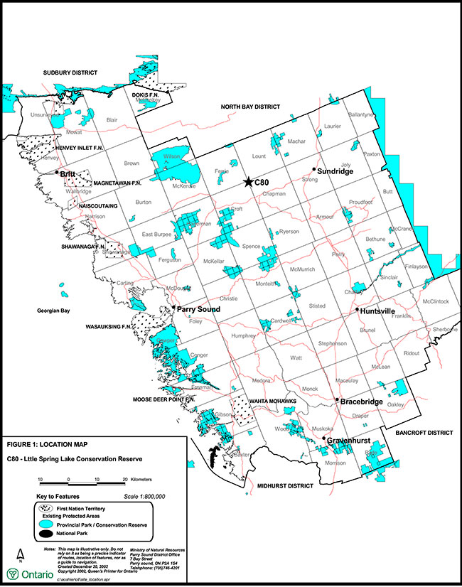
Enlarge Figure 1: Location of Little Spring Lake Conservation Reserve
Figure 2: Site Map – Little Spring Lake Conservation Reserve
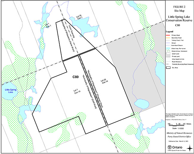
Enlarge Figure 2: Site Map – Little Spring Lake Conservation Reserve