Low/Bell Conservation Reserve Management Statement
This document provides policy direction for the protection, development and management of the Low/Bell Conservation Reserve and its resources.
C2201
Statement of Conservation Interest
November 2001
Prepared for the Ontario Ministry of Natural Resources Nipigon District
by Rebecca Zeran
OLL Resource Manager
Updated March 2, 2012
Next Examination Due March 31, 2022
Approval page
Statement of Conservation Interest for Low/Bell Conservation Reserve C2201
Nipigon District
Northwest Region
The purpose of this Statement of Conservation Interest is to identify the natural heritage values of the Conservation Reserve and to identify the activities which occur at this location. This Statement outlines the activities which will be permitted and those which will be prohibited. From this outline, the management direction for the site can be determined.
Approved and signed by:
Ian Hagman
District Manager
Nipigon District
Date: February 11, 2002
Approved and signed by:
Ralph Wheeler
Acting Regional Director
Northwest Region
Date: May 17, 2002
1. Introduction
On July 16, 1999, the Ontario Government released Ontario’s Living Legacy (OLL) Land Use Strategy (LUS) to guide the planning and management of Crown Lands within a large part of northern and central Ontario. A major component of this Land Use Strategy was the establishment of 378 new protected areas in this part of Ontario. This commitment will be the largest expansion of Provincial Parks and other protected areas in the history of Ontario.
The Low/Bell Conservation Reserve (C2201) is one site within this expansion of Ontario’s protected areas.
Conservation Reserves are areas of Crown land set aside by regulation under the Provincial Parks and Conservation Reserves Act, 2006 to complement provincial parks in protecting representative natural areas and specific landscape features. Most recreational activities (e.g. hiking, skiing, tourism related uses, nature appreciation) and non-industrial commercial activities (e.g. fur harvesting, bait fishing and commercial fishing) that have traditionally been enjoyed in the area will continue – provided that these uses do not impact upon the natural features requiring protection. Recreational hunting and fishing are permitted uses within all new conservation reserves identified through the OLL Land Use Strategy. Commercial timber harvesting, mining, aggregate extraction and hydroelectric development are prohibited in conservation reserves.
The Low/Bell Conservation Reserve consists of two separate sites located northeast of
Longlac.
- The first part is approximately 60 km northeast of Longlac, between the Flint River and the Selwyn River. (Part A)
- The second part is approximately 75 km northeast of Longlac, to the west of the Bicknell River. (Part B)
The sites contain lacustrine deposits with esker formations. The area is also located in a transitional zone between the boreal forest and the James Bay Lowlands (OLL Factsheet, 2001). More detail is available in the attached Earth Science Report and Life Science Report (please see Appendices 5 and 6).
Access to the conservation reserve is available by logging roads; however, both parts remain relatively remote at present. Road corridors provide access to the eastern sides of both parts of the conservation reserve, but the western sides are still not accessible by motorized traffic.
The purpose of this Statement of Conservation Interest is to identify the natural heritage values of the Low/Bell Conservation Reserve; this Statement also intends to identify the activities occurring within the reserve. Through a set of management guidelines, this statement will outline the activities which will be permitted and those which will be prohibited. From this outline, the management direction for the area can be determined.
2. Background information
| Name | Low/Bell Conservation Reserve |
|---|---|
| Ecoregion / Ecodistrict | 2W-2 |
| OMNR Administrative Region / District / Area | Northwest/Nipigon/ Geraldton Area |
| Total Area (ha) | 5,576 ha |
| Regulation Date | June 25, 2004 |
| Interested First Nations | Aroland, Ginoogaming, Long Lake #58, and Constance Lake First Nations |
| Lat./Long. | lat.: 49° 55' N & long.: 85° 37' W |
| Basemap | 498853, 501853, 498852, 498853 |
| FRI Stands | Specific numbers for the FRI stands occurring within the conservation reserve can be obtained by contacting the Information Management Team in Nipigon or Geraldton |
| General Location | Part A is located approx. 60 km northeast of Longlac, between the Flint River and the Selwyn River. Part B is located approx. 75 km northeast of Longlac, to the west of the Bicknell River. |
| Access | Access to the general vicinity of the reserve is by forest harvest roads. |
3. Representation Targets
This section provides a summary of the earth science, life science and cultural resource values represented in the site. It also outlines existing and potential recreational opportunities available.
| Life Science Representation | Black spruce swamps, representative of the transition to Hudson Bay Lowland regions, make up the majority of the vegetation cover in the site. Mixedwood stands, with trembling aspen components, are also found periodically within the site, usually associated with esker ridges. A series of small ponds and kettle lakes are located within the site. Small peatlands, on the edges of kettle lakes, are home to interesting and regionally significant plant communities. |
|---|---|
| Earth Science Representation | No bedrock exposures or unconsolidated sediment within the site. Generally low and flat topography. Prominent esker ridges characterize the area and are most likely related to the lacustrine deposits of glacial Lake Nakina. |
| Cultural Resource Representation | No documented cultural resources. |
| Recreational Opportunities | Opportunities exist for hunting and fishing. |
4. Survey Information
This section provides an overview of the inventories completed, their level of detail and any further inventory work required.
| Survey Level | Life Science | Earth Science | Cultural | Recreational |
|---|---|---|---|---|
| Reconnaissance | Yes, Nov. 2001 | Yes, Nov. 2001 | No | Yes, Dec. 2001 |
| Detailed | No | No | No | No |
| Requirement | No further requirement | No further requirement | No further requirement | No further requirement |
5. Natural & Cultural Heritage Values
This section provides a description of the key natural and cultural heritage values of the site and their condition relative to past and present resource use and management activities. It also addresses the sensitivity of these values to future land use and management activities.
The intent of this Statement is to protect those values identified in the site, by establishing guidelines for existing and potential uses of the area, given the level of past disturbances and the nature of existing features.
Forest values:
The entire forest area is to be protected from human disturbance. The forest cover on this site is representative of the surrounding area and is predominately fire origin mature stands.
Vegetation values
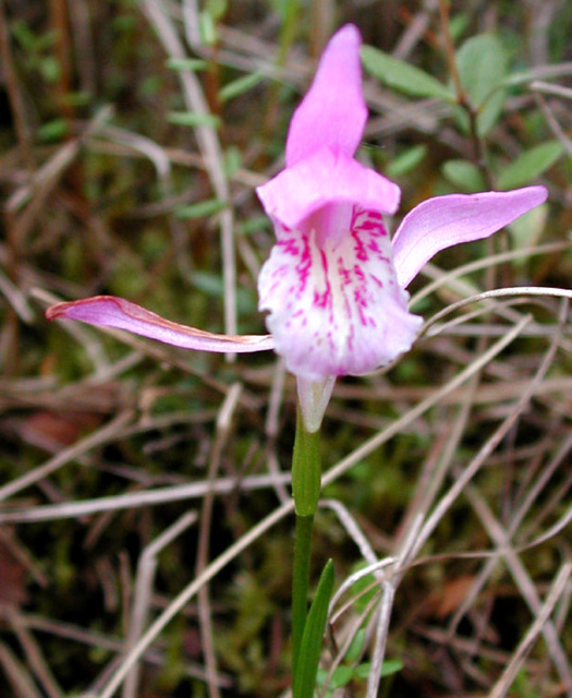
The site contains interesting and unique vegetation, such as horned bladderwort, English sundew, hooded ladies tresses and dragon’s mouth orchid, as well as a regionally rare plant – rusty cottongrass (Harris & Foster, 2001). The conservation reserve is regionally significant, containing representative forest and wetland communities in the transition zone from Boreal Forest to the Hudson Bay Lowlands.
Geologic values
Prominent and well-developed limestone-bearing esker deposits are located along the eastern boundaries of both sections of the reserve. The eskers are regionally rare within this site region and closely linked to the lacustrine deposits of glacial Lake Nakina (Gauthier, 2001). Limestone-bearing materials have been found to contain fossils in the Nakina Northeast Waterway Conservation Reserve 72 km to the northwest of this conservation reserve. When building forest access roads, contractors generally look for the most cost effective placement of the road. Generally, if eskers are present, this results in roads being built over or alongside esker ridges (adequate drainage and a ready supply of aggregate material). The esker ridges in this site are located along the eastern boundaries of both sections of the reserve. Several forest access roads and borrow pits have been built on the eskers adjacent to the eastern boundary of the conservation reserve. Additional roads may be built in this area in the future, but these should be minimized where possible and reclaimed once they are no longer deemed to be of use for resource extraction in the area. Further study would need to be conducted in order to ascertain whether or not the roads will be or are a risk to the eskers, as well as to whether or not it is an acceptable risk.
Wildlife values
Habitat conditions exist for beaver, mink, marten, otter, muskrat, weasel, moose, woodland caribou, bear, fox, hare, squirrel and upland birds.
Recreation & Tourism Values
Potential recreational activities within the reserve include recreational hunting and fishing. There is little evidence of traditional tourism use within the reserve. A canoe route may exist down the Flint River, however, its difficulty may limit its use.
Aboriginal Values
There is no knowledge of the current use of this site for traditional hunting, gathering or cultural activities. The MNR has no record that would indicate the levels of historical use for these activities, however, should any be discovered, they will be given appropriate priority and protection.
6. Management guidelines
The following topics briefly indicate the existing situation on Low/Bell Conservation Reserve and the management guidelines to be implemented or continued.
6.1 Land tenure
Low/Bell Conservation Reserve consists entirely of Crown land. No private land or development currently exists in the area; no future disposition or development will be permitted. No commercial land or development exists within the site; no future disposition or development will be permitted.
6.2 Existing and proposed development
A trail accessing a small unnamed lake (the middle lake of the three lakes on the eastern side of Part A) from the logging roads east of Part A of the reserve was built following the construction of these roads into the area. No new development that would disturb the forest or the forest understory vegetation will be permitted. The area will be managed primarily for low-impact recreation, hunting, fishing, public nature appreciation, educational experiences and scientific study. Major tourism facilities and development will not be promoted for the area due to the potential for site degradation.
6.3 Recreational activities
6.3.1 Summary
| Tourism | Few known tourism opportunities exist. There may be a canoe route down the Flint River, however, its difficulty will limit its use. |
|---|---|
| Recreational Fishing | A few small lakes, streams, and ponds are present within the reserve. The development of forest access roads along the eastern sides of both parts of the site have allowed for an increase in usage of these lakes, and a boat cache is now located at one of these lakes (the middle lake of the three lakes on the eastern side of Part A). |
| Recreational Hunting | Few known tourism opportunities exist; however, the general area is used extensively by hunters. The construction of forest access roads has already generated a higher level of use of the area as is noted in the sections above. Two bear management areas (BMAs) and four bait harvest blocks contain portions of the reserve. |
6.3.2 Guidelines
Low-intensity, non-structural activities that do not impact the health of the forest ecosystem (e.g. viewing, hiking, hunting, etc.) are permitted. ATV access and snowmobile usage will be closely monitored for possible damage to the trees and to the site’s ability to regenerate. If site degradation occurs, these activities may be excluded from the area. Access by non-mechanized means is the preferred method.
More information on the current use and recreational potential of this Conservation Reserve can be found in the Recreation Resource Assessment Report for the Low/Bell Conservation Reserve.
6.4 Commercial activities
6.4.1 Summary
| Mining | No mining claims exist within the reserve. Over 20 years ago there was some exploration activity in the general area of Part A (Dave Barker, 2001, personal communication). The lands of the CR have been permanently withdrawn from staking and exploration. |
|---|---|
| Aggregate | None known to exist on site, however several borrow pits exist in the eskers adjacent to the eastern portion of Part A. |
| Forest Harvest | Mature forest cover on the site is commercially merchantable. |
| Wild Rice | None observed on site. |
| Trapping | Traplines GE12, GE53 and GE230 all overlap the conservation reserve. |
| Bear Management Areas | Two BMAs overlap the reserve: GE-19-036 and GE-19-038 |
| Outpost Camps/Outfitters | None exist within the site. |
| Commercial Fisheries | Four baitfish blocks overlap the reserve: NI5109 & NI5093 (Part A), NI5094 & NI5095 (Part B). |
6.4.2 Guidelines
The site forms part of three active traplines and two active Bear Management Areas. There are four baitfish blocks that overlap the conservation reserve. These activities will be permitted to continue. No new trails, cabins or other development are permitted without specific authorization from the Ministry. However, the maintenance and repair of existing trails and cabins is permitted, as long as the scale and function of the trail or cabin is not significantly altered.
No other commercial activities are known to exist within the Conservation Reserve boundaries and no new commercial activities will be permitted (i.e., mining, hydroelectric development, logging, aggregate extraction, road development, utility corridors, peat development and topsoil removal).
The area of the Low/Bell Conservation Reserve has been permanently removed from the operable area of the Kenogami Forest Sustainable Forest License. The area has also been officially withdrawn from staking by means of a withdrawal order.
6.5 Aboriginal interests
Local First Nation communities were asked to provide input into the regulation of the Low/Bell Conservation Reserve. Meetings were held with Pays Plat First Nation to discuss the regulation of the Low/Bell Conservation Reserve (along with 5 other OLL sites). Pays Plat expressed no concern over the regulation of the Low/Bell Conservation Reserve.
Letters were sent to four ‘affected' First Nations within the Nishnawbe-Aski Nation (NAN), informing them of the regulation process and inviting them to comment and consult on the boundaries (this included Aroland, Ginoogaming, Long Lake #58, and Constance Lake First Nations). Similar letters were also sent to seven other NAN First Nations (Eabametoong, Kasabonika, Neskantaga, Marten Falls, Nibinamik, Webequie and Wunnumin Lake First Nations).
Meetings will not be held with NAN-member First Nations at this time. Consultation is currently underway between NAN and the Ministry of Natural Resources.
Regional and District offices received a letter from the Ontario Metis Aboriginal Association (OMAA) indicating a wish to participate in any management planning regarding OLL sites and also expressing the need to protect aboriginal rights such as hunting, fishing, trapping, and gathering. Consultation with OMAA is being coordinated at a corporate level.
Nothing in this Statement of Conservation Interest in any way affects existing or future aboriginal or treaty rights.
6.6 Natural resources stewardship
6.6.1 Vegetation management and fire management
MNR recognizes fire as an essential ecosystem process, fundamental to restoring and maintaining the ecological integrity of protected areas in the Boreal Forest Region. Fire management involves the protection of values and the attainment of resource management objectives through fire response and fire use. The Forest Fire Management Strategy for Ontario (OMNR 2004) provides strategic direction for the management of wildfire across Ontario. The Low/Bell Conservation Reserve is in the Boreal Fire Management Zone according to this provincial strategy. Fire management objectives within the CR will focus on preventing personal injury, value loss and social disruption, as well as using fire management techniques to perpetuate naturally occurring vegetation communities and help to restore and maintain ecological integrity.
Fires that pose a threat to public health and safety, property and infrastructure, or other values will receive a full response and sustained action. “Light on the land” fire suppression techniques will be used whenever feasible. These minimal impact suppression techniques do not unduly disturb natural or cultural values. Examples may include limiting the use of heavy equipment or the felling of trees during fire response.
6.6.2 Fish and wildlife management
Fisheries and wildlife will be managed in accordance with existing policies. Opportunities for wildlife viewing will be encouraged.
The conservation reserve is part of the Pagwachuan (Continuous) woodland caribou range according to the Caribou Conservation Plan and as such management objectives will contribute to the enhancement of woodland caribou habitat (OMNR 2009).
6.6.3 Landforms
No management requirements exist for this category, except that significant and unique landforms should be afforded continued protection as a natural resource.
6.7 Cultural resource stewardship
There are no requirements at this time based on existing information. The Ministry of Natural Resources will continue to work with the Ministry of Tourism and Culture’s regional chief archaeologist to identify archaeological sites requiring further protection. To date there has been no field survey to assess cultural resources in the Low/Bell Conservation Reserve and the potential for archaeological finds is unknown.
6.8 Client services
Nipigon District and the Information Management Team staff will be the primary contact for responding to inquiries about the basic level of information such as access, nature appreciation, scientific study requests, wildlife viewing opportunities, hunting, permitted uses and boundaries.
6.9 Research
Non-destructive scientific research by qualified/recognized Canadian institutions or organizations that will contribute to the Ministry of Natural Resources natural heritage information base will be encouraged. All research programs will require the approval of the Ministry of Natural Resources and will be subject to ministry policy and other relevant legislation.
6.10 Marketing
Activities will include producing a fact sheet highlighting the importance of the reserve and responding to inquiries about the site. There are no other requirements at this time.
7. Implementation
Implementation of this Statement of Conservation Interest will primarily involve monitoring activities to ensure adherence to management guidelines. The conservation reserve will be managed under the supervision of the Information Management Team supervisor (Nipigon District) and the Geraldton Area supervisor. Any affected clients will be notified of any amendments to this Statement of Conservation Interest.
The Low/Bell Conservation Reserve was regulated in 2004 (by Ontario Regulation 86/01) under the Public Lands Act, following the process set out in Ontario’s Living Legacy Protected Areas Regulation Implementation Manual and is now governed by the Provincial Parks and Conservation Reserves Act, 2006 and the Protected Area Planning Manual (MNR 2000, 2009).
8. Review and revisions
Any changes that may occur to the management direction outlined in this Statement of Conservation Interest for the Low/Bell Conservation Reserve will be evaluated for their significance. Minor changes, which do not alter the overall protection objectives, may be considered and approved by the Area Supervisor. Local consultation may also be required, as determined by the Area Supervisor. The need for a more comprehensive planning process will be considered in the case of major changes. Any major amendments to this document will require public consultation and the approval of the District Manager and Regional Director.
In accordance with the Provincial Parks and Conservation Reserves Act, 2006, MNR will examine management direction documents that have been in place for 10 years or more. The next scheduled examination for the Low/Bell Conservation Reserve will be in 2022.
9. Public consultation
9.1 Results of past consultation
Low/Bell Conservation Reserve has been a part of the land use planning and consultation process:
- Lands for Life round table consultation (June 1997 to July 1998)
- Ontario Forest Accord (1999)
- Ontario’s Living Legacy round table discussions (1999)
- OLL Site Regulation and Public Consultation Process (June 2001)
During the Ontario’s Living Legacy Land Use Strategy site regulation and public consultation process for the Low/Bell Conservation Reserve, contact was made with local stakeholders. In June of 2001, letters from the District Manager were sent to First Nations, representatives from the forestry industry, trappers, municipalities, landowners, prospectors, fish and game clubs, trail and recreational clubs, and tourist operators/outfitters. Newspaper advertisements were also released at this time.
No comments (written or verbal) were received regarding Low/Bell Conservation Reserve (see Appendix 7 for a copy of the OLL Public and Aboriginal Consultation Documentation Form for Low/Bell Conservation Reserve). Meetings were held with Pays Plat First Nation to discuss the regulation of the Low/Bell Conservation Reserve (along with 5 other OLL sites). Please see section 6.5 for an account of the comments put forward by First Nations. Concerns that arose with respect to the establishment of the conservation reserve were addressed accordingly.
9.2 Present and future consultation
Further widespread consultation is not deemed necessary at this time because of the extensive consultation that has already occurred to date.
Once the Low/Bell Conservation Reserve has been formally regulated under the Public Lands Act, Decision Notices will be sent to all members of the public who expressed interest in the site. Notices will also be sent to all First Nations, industry and municipal organizations potentially affected by the regulation of this site.
10. References
Gauthier, Dave. (2001). Earth Science Inventory Checksheet and Report for the Low/Bell Conservation Reserve (C2201).
Harris, Allan and Rob Foster. (2001). Life Science Inventory Checksheet and Report for the Low/Bell Conservation Reserve (C2201).
Ministry of Natural Resources. (1999). Ontario’s Living Legacy Land Use Strategy, Queen’s Printer for Ontario, Ontario Canada.
Ministry of Natural Resources. (2000). Protected Areas Regulation Implementation Manual, Internal Document.
Ontario Ministry of Natural Resources. (2001). Low/Bell Conservation Reserve (C2201) Fact Sheet, June 2001, Public Document.
Ontario Ministry of Natural Resources. 2009. Ontario’s Woodland Caribou Conservation Plan. Queen’s Printer for Ontario. Toronto, Ontario, Canada. 24 pp.
Appendix 1: Site location reference map
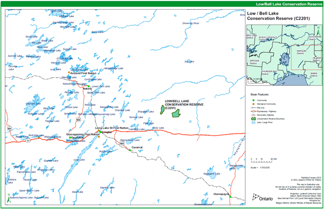
Enlarge location Appendix 1: Site location reference map
Appendix 2: Site and values map for the Low Bell Conservation Reserve
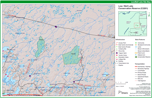
Enlarge Appendix 2: Site and values map for the Low Bell Conservation Reserve
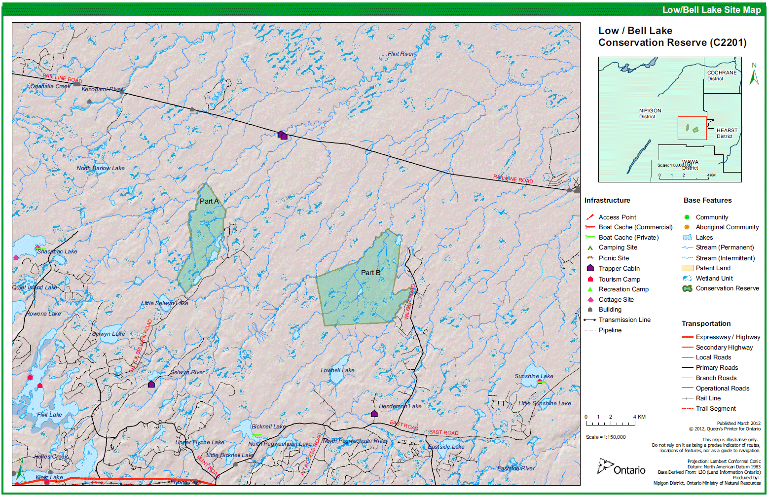
Appendix 3: Permitted uses table, Low Bell Conservation Reserve
| Activity/Value | Permitted | Not Permitted | Modified | District Manager Approval |
|---|---|---|---|---|
| Sport Hunting | Yes | |||
| Commercial Trapping | Yes | |||
| Boating / Canoeing / Kayaking | Yes | |||
| Baitfishing | Yes | |||
| Commercial Wild Rice Harvest | N/A | |||
| Mineral Exploration & Extraction | Yes | |||
| Land Disposition for Private Purposes | Yes | |||
| All-Terrain Vehicle | Yes | |||
| Snowmobile | Yes | |||
| Land Claims | Yes | |||
| Traditional Use | Yes | |||
| Native Hunt Camps | Yes | |||
| Commercial Tourism Based Hunting | Yes | |||
| Native Hunting | Yes | |||
| Commercial Native Trapping | Yes | |||
| Wildlife Management | Yes | |||
| Commercial Forest Operations | Yes | |||
| Vegetation Management (i.e. herbicides) | Yes | |||
| Timber Harvest for Personal Use | Yes | |||
| Fuelwood Harvest | Yes | |||
| Insect & Disease Suppression | Yes | |||
| Sport Fishing | Yes | |||
| Commercial Fishing | Yes | |||
| Native Fishing | Yes | |||
| Water Control Structures | Yes | |||
| Aggregate Extraction | Yes | |||
| Bear Management Areas | Yes | |||
| Trapline Cabins | Yes | |||
| Wild Rice Harvest | N/A | |||
| Boat Caches | Yes | |||
| Fire Management | Yes | |||
| Archeological Study | Yes | |||
| Backcountry Travel | Yes | |||
| Wildlife / Vegetation Viewing | Yes | |||
| Photography | Yes | |||
| Hiking | Yes | |||
| Rock Climbing | N/A | Yes | ||
| Mountain Biking | ||||
| Nordic Skiing | Yes | |||
| Snowshoeing | Yes | |||
| Aircraft | Yes | |||
| Roads / Bridges / Culverts | Yes | |||
| Ongoing Research | Yes | |||
| New Research | Yes |
"Modified" – refers to a use which may be permitted under certain circumstances where the use would not impact the values for which the Conservation Reserve was created to protect (e.g. new trails, clearings/docks for aircraft access, etc.)
Figure 1: Aerial view of small kettle lakes and ponds in Part A. Photograph by Allan Harris.
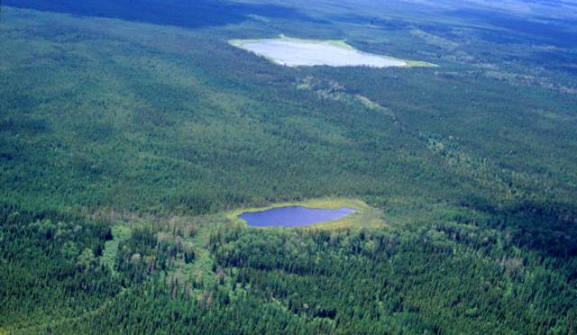
Figure 2: Ponds and shore fens in Part A of the conservation reserve. Photograph by Allan Harris.
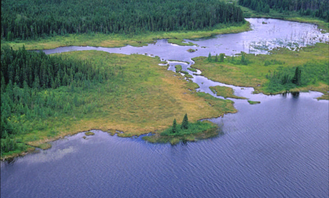
Figure 3: Esker formation (to the bottom right-hand side of the lake in the photo) in Part B of the Low/Bell Conservation Reserve. Photograph by Charles Faust.
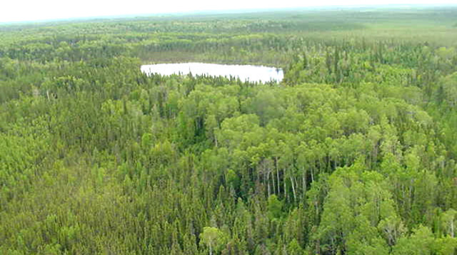
Figure 4: Vegetation on an esker – the dominance of trembling aspen can easily be observed from this photo. Photograph by Charles Faust.
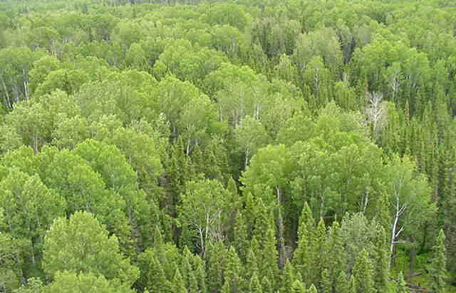
Figure 5: Forest access road along the esker ridge beside the eastern boundary of Part A of the Low/Bell Conservation Reserve. Photograph by Allan Harris.
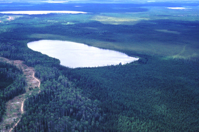
Figure 6: Shore fen. Photograph by Allan Harris.
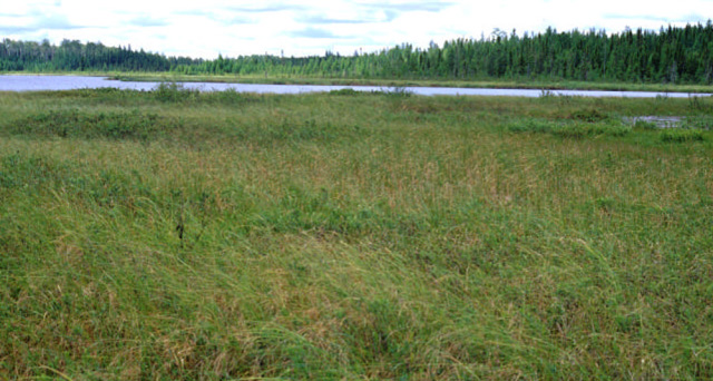
Figure 7: Aerial view of the Low/Bell Conservation Reserve, Part B. Photograph by Charles Faust.
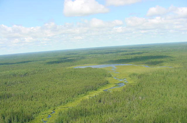
Figure 8: Shore wetland area in Part B of the Low/Bell Conservation Reserve. Photograph by Charles Faust.
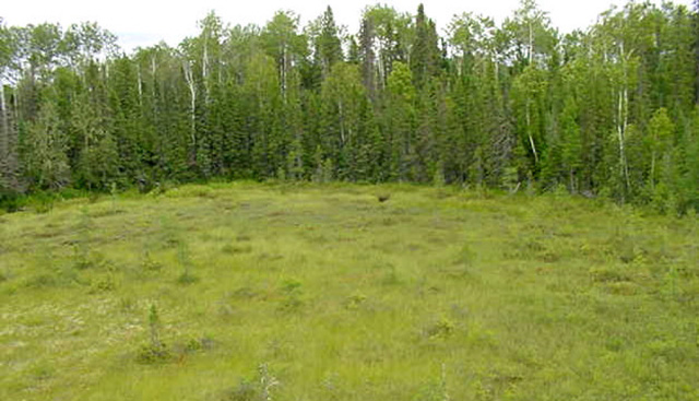
Figure 9: Pitcher Plant (Sarracenia purpurea). Photograph by Charles Faust.
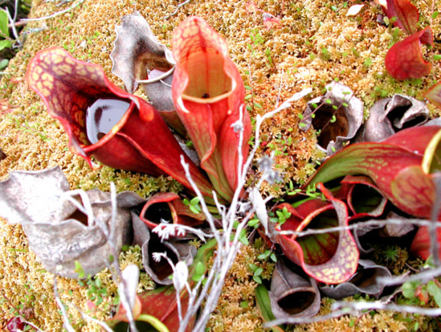
Figure 10: Flower head of the pitcher plant, Sarracenia purpurea. A carnivorous plant adapted to nutrient-poor conditions, the pitcher plant is one of four carnivorous plant genera in Ontario. Photograph by Charles Faust.
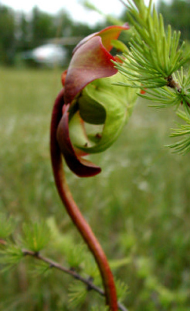
Figure 11: Dragon’s Mouth Orchid (Arethusa bulbosa). This is the only species of this genus located in Canada. Populations of this orchid can fluctuate greatly from year to year, especially if late frosts kill the flowers, suggesting that this orchid is short-lived and relies on heavy seed production to maintain its populations (Johnson et al., 1995). Photograph by Charles Faust.