Matabitchuan River Conservation Reserve Management Statement
This document provides policy direction for the protection, development and management of the Matabitchuan River Conservation Reserve and its resources.
Statement of Conservation Interest
January 2002
Ministry of Natural Resources
North Bay District
Approval statement
I am pleased to approve this Statement of Conservation Interest for the Matabitchuan River Conservation Reserve (CR 3a).
This Statement of Conservation Interest (SCI) will provide guidance for the management of the conservation reserve and the basis for the ongoing monitoring of activities.
Direction for establishing, planning and managing conservation reserves is defined under the Public Lands Act and current policy. "Ontario’s network of natural heritage areas has been established to protect and conserve areas representative of the diversity of the natural regions of the province, including species, habitats, features and ecological systems which comprise that natural diversity." (Policy 3.03.05, MNR 1997). The Matabitchuan River Conservation Reserve offers an ecologically diverse landscape representative of the Southern Boreal Site Region. Furthermore, it contributes a richness of cultural and social values.
The management and administration of the Matabitchuan River Conservation Reserve will be guided by this SCI. Should significant facility development be considered or complex issues arise requiring additional studies, further management direction or special protection measures, this SCI will be amended or a more detailed Resource Management Plan (RMP) will be prepared with full public consultation.
The direction contained in this SCI is consistent with the Ministry of Natural Resources' (MNR) 1997 Temagami Land Use Plan (TLUP). The public was consulted about this site prior to its regulation during land use planning for the Temagami Comprehensive Planning Area. Comments from that planning exercise were considered during the development of this document. The TLUP provides detailed direction on future uses and resource management targets for this area. No new decisions have been made with regards to the conservation reserve since the approval of the TLUP.
The Matabitchuan River Conservation Reserve will be managed under the direction of the Temagami Area Supervisor, North Bay District Ministry of Natural Resources (MNR).
Signed by:
Dave Payne
District Manager Recommendation
For Approval
Date: January 08, 2002
Signed by:
Rob Galloway
Regional Director
Date: January 15, 2002
1.0 Introduction
Ontario boasts a varied and diverse landscape. Many demands are placed on its resources for both social and economic benefit. The current planning process is committed to the protection of natural and cultural heritage values represented throughout the province. The MNR has developed strategies that will maintain the integrity and sustainability of these areas.
The Temagami Land Use Plan provides direction for the administration and management of parks and protected areas within the Temagami Comprehensive Planning Area. Included in the plan is a natural heritage objective to maintain the full spectrum of the area’s ecological and geological diversity. Specifically the TLUP protects representative "old growth" red and white pine stands, some watersheds related to Lady Evelyn-Smoothwater Provincial Park, significant wetlands and provincially significant ecological, geological and recreational features.
The Matabitchuan River Conservation Reserve has been selected as a site representing old growth red and white pine forest communities. Further studies are required to identify other possible ecological associations and their significance. In addition, it fulfills many social requirements both locally and provincially.
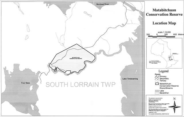
This 82 hectare parcel of Crown land is located in the Northeast planning region of the MNR, approximately 40 kilometers south of the town of Haileybury, Ontario within the township of South Lorrain (see Location Map).
The purposes of this SCI are to;
- Provide background information and identify and describe the values of the Matabitchuan River Conservation Reserve
- Provide guidelines for the management of current and future activities while protecting natural social and cultural heritage values
This document has been prepared following the format of an SCI, also called a stewardship document. The SCI format was selected since, after extensive consultation, no new issues emerged. New uses may be considered provided they meet the requirements of a Test of Compatibility (Appendix A).
This SCI governs the lands within the regulated boundary of the Matabitchuan River Conservation Reserve; however, to ensure MNR protection objectives are being fully met within the conservation reserve, activities on the surrounding landscape must be considered. In addition, it is the intent of this SCI to create a public awareness that will promote responsible stewardship of protected areas and surrounding lands in Ontario. With management partners such as Ontario Parks, industry, local governments, etc., MNR district offices will be able to pursue and advance sound environmental, economic and social strategies and policies related to the protection of conservation reserves and provincial parks.
2.0 Goal and objectives
2.1. Goal of the SCI
The goal of the Matabitchuan River Conservation Reserve SCI is to describe and to protect natural and cultural heritage values on public lands while permitting compatible land use activities.
2.2. Objectives of the SCI
2.2.1. Short term
- To identify the State of the Resource with respect to natural heritage values and current land use activities for the conservation reserve
- To manage the conservation reserve to protect the integrity of its natural values via specific guidelines, strategies and prescriptions detailed in this plan
- To meet planning requirements by designing this SCI document to address the immediate planning arid management needs of the conservation reserve
2.2.2. Long term
- To establish representative targets (e.g., future forest conditions) and validate the conservation reserve as a potential scientific benchmark
- To identify research/client services and marketing strategies
- To give direction to evaluate future or new economic ventures (i.e., through use of a Test of Compatibility evaluation)
3.0 Management planning
3.1. Planning context
3.1.1. Planning area
The planning area for this SCI is the regulatory boundary of the Matabitchuan River Conservation Reserve. As noted earlier, planning for other activities on the surrounding landscape must consider the protection objectives and values of the conservation reserve. Any strategies noted within this plan related to the conservation reserve’s boundary or beyond, will be presented for consideration within a larger planning context such as a Forest Management Plan (FMP).
3.1.2. Management planning context
The Comprehensive Planning Council (CPC) (a citizens advisory group which was directed to submit land use recommendations for the Temagarni Comprehensive Planning Area) recommended that this site along the Matabitchuan River be designated as a conservation reserve. This recommendation, along with others, was submitted in April 1996 and accepted in principle by the government of Ontario in June 1996. The decisions on the recommendations were ultimately reflected in the TLUP.
The Matabitchuan River site was regulated as a conservation reserve on July 19, 1997 by Ontario Regulation 259/97.
The Matabitchuan River Conservation Reserve is designated as Management Area 3a, page 33, in the TLUP. By regulation under the Public Lands Act, lands within conservation reserves cannot be used for mining, commercial forest harvest, hydroelectric power development, the extraction of aggregate and peat or other industrial uses. Impacts of mineral exploration will be minimized and restored upon completion.
Traditional uses within the conservation reserve as noted in the permitted uses table of the TLUP will continue; however, the goal will be to resolve conflicts between uses and to ensure that identified values are protected.
When considering future permitted uses and/or development(s), there are established mechanisms in place to evaluate these proposals. These include, but may not be limited to; Procedural Guideline B - Land Uses - Test Of Compatibility Policy PL 3.03.05 (OMNR 1997). Class Environmental Assessment for MNR Resource Stewardship and Facility Development Projects (OMNR 2001), with accompanying Environmental Checklist or Exemption Order MNR 26/7 for future dispositions. Other protocols may be developed that address site specific sensitivities to identified features within the conservation reserve.
Consideration for proposals pertaining to cultural resources may be screened through Conserving a Future for our Past: Archaeology, Land Use Planning & Development in Ontario, Section 3 (MCzCR, 1997) and MNR's AOC Descriptions and Prescriptions (Cultural Heritage Resources) for the 1999-2019 Temagami FMP or its successor.
These planning tools will refine the review process once a proposal satisfies the direction and intent of the TLUP.
3.2. Planning process
Once a conservation reserve is regulated, there is a need to determine the level of management planning required to fulfil the protection targets. There are two policy documents to select from; a Statement of Conservation Interest (SCI) or a Resource Management Plan (RMP). A SCI does not address new issues, conflicts or proposals, so public consultation is not required. A RMP does address more complex issues and conflicting demands placed upon a protected resource and involves full public consultation.
The guidelines for the preparation of these documents are outlined in Procedural Guideline A-Resource Management Planning (PL 3.03.05, Public Lands Act). The appropriate plan is to be completed within three years of the regulation date.
For current planning purposes, the Matabitchuan River Conservation Reserve will be managed under the directive of a SCI. The intent of this SCI is to fulfil the commitments made under the Public Lands Act, the TLUP and other associated policies.
In July 1989 in response to growing public concern with respect to the use and management of resources wit in the Temagami area, MNR announced the Temagami Area Comprehensive Planning Program (CPP). The resulting TLUP was based on advice of the Comprehensive Planning Council. Through this process, extensive public consultation occurred. Based on past public participation and the fact that the land use direction presented within this SCI does not differ significantly from the TLUP, additional consultation at this time is not needed.
Public consultation will be solicited during the review of any future land use proposals that would require new decisions to be made beyond the intent of the TLUP. Such amendments to the TLUP and this document or its successor will also be posted on the Environmental Bill of Rights registry (EBR).
This SCI is a policy document that will provide background information, identify values to be protected and establish management guidelines for use in the administration of the conservation reserve.
The implementation of the policy will be the mandate of the MNR at the district level; however, associations with various partners may be sought to assist in the delivery. It must be noted that this SCI is a working document and it will be necessary to make revisions to 'it from time to time. If changes are required they will occur through a standard process of minor or major amendments (see Section 6.5).
4.0 Background information
4.1. Location and site description
4.1.1. Location
The following table describes the location and provides administrative details of the conservation reserve:
| Name | Matabitchuan River Conservation Reserve |
|---|---|
| Site Region-Site District (Hills 1959) | 4E Lake Temagami- 4E-4 Temagami |
| OMNR Administrative Region/District/Area | Northeast/North Bay/Temagami |
| Total Area | 82 ha |
| Regulation Date | June 26, 1997 (O. Reg. 259/97) |
| First Nations | Temagami First Nation and Teme Augama Anishnabai |
| OBM map sheets | (2017 6100152100, 52200 |
| UTM Coordinates | 615000,5219700 |
| Municipality | N/A |
| WMU | 40 |
| Townships | South Lorrain |
| Status | 100% Crown Land |
4.1.2. Site description
4.1.2.1. Physical description
The Matabitchuan River Conservation Reserve is an 82 ha parcel of Crown land, situated in Northeastern Ontario south of the town of Haileybury (South Lorrain Township). The site features stands of "old growth" red and white pine, which occupy approximately 65% of the conservation reserve. The area is located within Site District 4E-4 (G.A. Hills 1959 and Grins and Uhlig 2000), and consists of a flat lacustrine plain of stratified silt and clay surrounded by moderate-relief topography and bedrock knobs (Kor, 2001).
Much of the southern portion of the conservation reserve is bounded by the Matabitchuan River shoreline within the lower reaches of the Matabitchuan River watershed, which has its origin in the Thieving Bear Lake/Rib Lake area (Best Township).
The old growth red and white pine that exists throughout the conservation reserve have been aged at up to 130 years old, and is 80-90% stocked. Ten to one hundred year old poplar stands stocked to 80% are also found here. The conservation reserve also contains the following tree species; white birch, white spruce, red maple and balsam fir in varying mixes. Much of the forest cover, primarily the old growth, is in a state of declining health. Sparse branching and broken tops, has resulted in a relatively open canopy in many sections (Thompson et al, 2001).
Preliminary analysis for representation showed 6 landform/vegetation combinations dominated by dense coniferous or deciduous forest. The most current map sheets and a reconnaissance survey by Thompson, 2000 indicated that the conservation reserve may in fact contain a minimum of 27 forest communities as well as a number of disturbed areas containing shrubs, grasses and predominantly grassy meadows (Thompson et al, 2001). These areas may significantly add to the conservation reserves overall diversity.
4.2. Administrative description
The legal boundaries of the Matabitchuan River Conservation Area were certified by the Surveyor General of Ontario in the Ministry of Natural Resources at Peterborough on the 21st of February 1997. It was passed into regulation on July 19, 1997 (O.Reg. 259/97).
4.3. History of the site
There are several man made disturbances that adjoin this small conservation reserve. Ontario Power Generation (OPG) has a Hydroelectric power generating station on the Matabitchuan River just west of the conservation reserve.
Temagami First Nation (TFN) and Teme Augama Anishnabai (TAA) members have had a long-term relationship with the Matabitchuan River for a variety of social and economic reasons.
In recent years, an interest by the visiting public and the scientific community has evolved for the natural and social aspects of the site by the visiting public and the scientific community. Typically, the conservation reserve is used for outdoor recreational activities, commercial use (i.e., fur and baitfish harvesting), nature appreciation and scientific and educational pursuits.
4.4. Inventories
The following table indicates what survey work has been done in the conservation reserve and what is required:
| Survey Level | Reconnaissance | Detailed | Future Requirement |
|---|---|---|---|
| Life Science |
Noble, T.N. 1983. Life Science Report for Site Region 4E. OMNR, 1999. Forest Resource Inventory (FRI) Mapping: Matabitchuan River. Thompson, J.E., 2000 Aerial Reconnaissance Survey. Thompson, J.E., N. Avoledo, M. Lajeunesse and J. Joyce. 2001. Life Science Checksheet-Matabitchuan River. |
Detailed ecological survey. | |
| Earth Science |
Aerial photography (1988). Kor, P.S.G.2001. Earth Science Checksheet-Matabitchuan River. |
Not required. | |
| Cultural |
Preliminary Review of Heritage Resources, C.P.P.1991. MNR Archaeological Prediction Modeling, 1998 (Temaaarni FMU). |
Historical Mapping, (Craig McDonald1995). | May be required. |
| Recreational |
Mutch, J., 2000. Aerial Reconnaissance Survey. Roberts, S.K. 2001. Recreational Checksheet: Matabitchuan River. |
||
| Other |
5.0 State of the resource
5.1. Representation
The Matabitchuan River Conservation Reserve typically exhibits stands of representative old growth red and white pine, with scattered white birch, poplar and white spruce over a rolling plain of rock knob uplands. This is overlain by a shallow layer of stony, silty sand, broken by occasional trains of sorted coarse and medium sand over granite bedrock (Rowe, 1977). These lacustrine deposits were deposited in the Temiskaming Basin when its post-glacial extent was greater (Kor, 2001). The geological features are not considered highly significant here due to the conservation reserve’s small size and past disturbances. Representation of this formation can be found elsewhere in the district.
A previous reconnaissance survey conducted by Thompson, 2000 indicated that a minimum of 27 forest cover types may be represented in this area. This is in part due to the presence of disturbed areas that now contain varied grass/shrub communities.
The southern boundary of the conservation reserve is closely associated with the Matabitchuan River, a significant waterway, which includes an important walleye and white sucker spawning and migration area.
5.1.1. Quality of the representation
The quality of the representation or the current characteristics of the natural features found within a conservation reserve are as important as the overall representative features that are being protected. A number of factors are considered in evaluating the quality of a conservation reserve’s representative features. They include diversity, condition, ecological factors, special features and current land use activities.
-
Diversity:
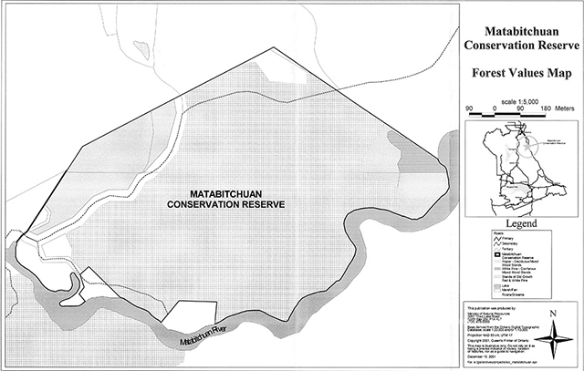
This conservation reserve contains only 3 dominant forest covers. These include red and white pine, poplar and white birch mixed woods (see Forest Values Map). As a result of this limited cover variation, it contains relatively little plant diversity and species richness. However, the conservation reserve does possess an even distribution of cover types with pine being the most dominant. Disturbed areas containing early successional plants and possibly some shoreline fen areas along the river may add to this diversity (Thompson et al, 2001).
-
Condition:
Unfortunately, human disturbance levels within and adjacent to this small conservation reserve are high. Site fragmentation results from the presence of a hydropower house, 2 private cottage lots and a private recreational camp found adjacent to the southern and southwestern boundary. Additionally, a transmission corridor and access road interrupts the northern section. Patent land can also be found abutting the entire northern boundary of the conservation reserve.
-
Ecological factors:
The design of the conservation reserve has utilized a southern river boundary that will help to buffer the conservation reserve from adjacent land uses over time. The conservation reserve’s small size limits the protection of core values. The vectored portion of the eastern boundary bisects the old growth values that need protection (Thompson et al, 2001). The secondary road that cuts through this conservation reserve potentially contributes to the vulnerability of these values, as it provides easy access. Considerations in large landscape planning will have to occur to ensure that values are protected along the conservation reserves sensitive boundaries (Thompson et al, 2001).
In general, the large number of activities currently allowed under the TLUP could be problematic in maintaining the quality of representation that presently exists here, over time (Thompson et al, 2001).
-
Special features:
This conservation reserve possesses a number of notable features, which possess varying degrees of significance. These features include:
- Old growth stands of red pine, white pine and poplar in close proximity to one another
- The southern boundary falls adjacent to a significant walleye and white sucker spawning and migration route (Matabitchuan River)
- Access to the Matabitchuan River fishery
-
Current land use activities:
A wide range of land use activities occur within or are associated with the conservation reserve. Activities include the following: hunting, trapping, fishing, boating, canoeing, nature activities, and trail use (e.g., non-motorized and motorized use).
The accessibility of the conservation reserve provides the public with an opportunity to easily observe a unique old growth forest in its natural setting.
Viewing of the forest, and its associated wildlife, can take place along the roadways and along the informal trails that support hiking, snowshoeing and cross-country skiing activities. Snowmobile and ATV use also occurs on right-ofways.
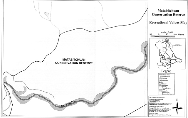
The southern boundary of the conservation reserve is defined almost entirely by the Matabitchuan River, which provides a popular canoe route, linking the town of Temagami to the Ottawa River Valley. Hence, many water-based activities are associated with the conservation reserve such as boating, angling, swimming, wildlife viewing, and heritage viewing (e.g., a log flume with a 200 ft vertical drop). (see Recreational Values Map)
The general location of the conservation reserve places it within a valued heritage area. The mouth of the Montreal River, Beaver Mountain and Lower Notch can all be found within a few kilometers. In addition to these notable sites, prehistoric and historic settlements, and an operating hydro generating station dating from 1910 can also be found in the vicinity.
Human usage within and proximal to this conservation reserve is quite high. A hydropower house, a private recreational camp and associated cottages are found along the southwestern boundary. The northern and eastern boundaries border farmland and other patented land, while a cleared corridor accommodating transmission lines interrupts the northern section.
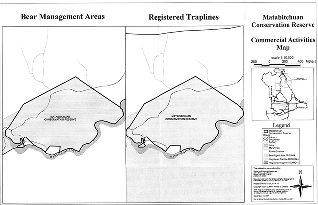
Commercially, the site lies within registered fur trapline TE01N011 and Bear Management Area (BMA) TE-28-69. It is suspected that these activities are not intense and may have limited conflict with other interests. Recreational hunting is also permitted, with the primary game species being moose, bear and ruffed grouse.
Summary:
The Matabitchuan River Conservation Reserve contains provincially significant old growth red and white pine communities. This forest cover dominates much of the area and contributes highly to the relatively low level of species diversity found here. Overall, the design of this conservation reserve and its disturbance levels makes it very sensitive to potential overuse. It is situated in an accessible location and is attractive to recreationalists. Additionally, this conservation reserve is located in an area of very high heritage value. The natural linkages connect the conservation reserve to the surrounding forested and aquatic landscapes found within the Temagami Region. This illustrates the conservation reserve’s importance to the provincial parks and protected areas system.
5.2. Social/economic interest in the area
-
Linkage to local communities:
The Matabitchuan River Conservation Reserve consists entirely of Crown land and is easily accessible to the public via road or water. This area is an attractive destination for day travelers and seasonal residents.
It is well suited for outdoor recreation, nature appreciation and educational opportunities. Its proximity to Lake Temiskaming, along with ease of access, makes the Matabitchuan River Conservation Reserve a logical choice for a variety of back-country users. In a regional context, the conservation reserve offers natural and cultural heritage features that generate interest in ecotourism, recreational and tourism markets.
Currently the conservation reserve is available for a variety of recreational pursuits.
Associated with the conservation reserve are a few hiking trails that lead to Beaver Mountain Lookout and Copper Lake. These trails offer day and overnight routes. Canoeists or other interested users may be attracted to this opportunity and include it in their trip.
There are several recreational outdoor outfitting companies and resort lodges in the surrounding area of New Liskeard, Haileybury and Cobalt (Tri-Towns) that may wish to expand their use of the Matabitchuan River Conservation Reserve.
Outdoor education and scientific research potential in the conservation reserve is moderate and will be encouraged. Its red and white pine stands are representative of a natural old growth forest and provide opportunities for viewing old trees, wildlife snags, plant species, a succession community, etc.
-
Heritage estate contributions:
The Matabitchuan River Conservation Reserve contributes to the province’s parks and protected areas system through its regulation, representation and the long-term management of its natural heritage values.
By allocating these lands to the parks and protected areas system through regulation, the province has ensured a certain level of permanence by distinguishing the conservation reserve and its values from the larger general use or more extensively managed landscape. In addition, its natural features are, and will be available for present and future generations to enjoy and explore.
The conservation reserve’s ecological features make a number of contributions to the province’s natural heritage estate. The old growth red and white pine communities contribute significantly to the provincial parks and protected areas system. Its location, design and features make a distinctive contribution to quality recreational experiences that include hiking trails both within and adjacent to the conservation reserve, and riverine shorelines.
Its connection to the Ottawa River Valley (Lake Temiskaming and the mouth of the Montreal River) and regional canoe routes and waterways adds considerably to the over-all value of the conservation reserve.
Long term management must consider public access to the conservation reserve, its protection objectives, and commitments made in the Temagami Land Use Plan. Future managers will have to balance between maintaining the quality of the current representation and the needs of recreational and other users.
-
Aboriginal groups
The Matabitchuan River is within the ancestral homeland, known as n'Daki Menan, of the TFN and TAA.
All Aboriginal and treaty rights will continue to be respected throughout the management of this conservation reserve. Any future proposal(s) and/or decision(s) that have potential impact(s) on individual aboriginal values and/or communities will involve additional consultation with the affected aboriginal groups.
-
Mining industry:
All mining rights were withdrawn based on the boundaries established in the Temagami Land Use Plan prior to the lifting of the land caution. Minor boundary refinements were required primarily to define the site on the ground for regulation purposes. The mining rights were re-withdrawn in January 2001 to be consistent with the boundaries regulated in 1997.
The Matabitchuan River Conservation Reserve is designated as Management Area 3(a) in the Temagami Land Use Plan. Lands to the west outside of the conservation reserve boundary area are designated as Special Management Area (SMA) 3(b). An application has been made to expand this site into 3(b), which would add 33 hectares to the total area of the conservation reserve (as per direction in Management Area 3 in the TLUP). In the event that the staked areas revert to the Crown, MNR will apply for their withdrawal from the mining land base.
-
Forest management
No commercial forest harvesting is permitted in conservation reserves. Forest activities on the adjacent landscape are guided by the Forest Management Plan (FMP). Based on the current plan (1999-2004), the following provisions apply:
Harvesting, renewal and maintenance activities are permitted up to the conservation reserve boundary. Where the integrity of the boundary may be affected by blowdown (e.g., based on slope, aspect relative to prevailing winds, soils, species, size and type of adjacent cuts, etc.), the need for additional protection will be determined during development and planning of the annual work schedule.
No roads or landings are permitted within 100 m of the boundaries of nonwaterway conservation reserves, except where it can be demonstrated that no alternative alignments are available and with MNR approval. Roads will be planned to minimize potential access to conservation reserves (e.g., perpendicular to conservation reserve boundaries).
Presently there is no Sustainable Forestry License (SFL) within or adjacent to the conservation reserve. The Temagami Forest Management Unit is currently managed by the Crown. The North Bay District office (Temagami Area) administers Forest Resource Licensing (FRL) in this unit.
-
Utilities
A hydro transmission line is present in the northern portion of the conservation reserve. A hydroelectric power generating station is located just outside the western boundary, on the Matabitchuan River.
5.3. Natural heritage stewardship
Preliminary analysis of the life science targets based on landform/vegetation combinations have shown that the conservation reserve contains a minimum of 6 such combinations dominated by dense coniferous or deciduous forest (see Forest Values Map). As mentioned previously, a minimum of 27 forest cover types may exist here.
A recent aerial reconnaissance survey showed no wide spread forest disturbance due to forest harvesting, fire, insect, wind throw, wildlife damage, ice storms or other natural disturbances.
Water levels on the Matabitchuan River are influenced by two means; firstly Ontario Hydro operates a dam to control levels within the Matabitchuan River. Secondly, a large influence is from Lake Temiskaming, which is controlled by Public Works and Government Services Canada. Water levels on the Matabitchuan River fluctuate significantly during the year.
5.4. Fisheries and wildlife
There have been no detailed wildlife studies undertaken within the conservation reserve, with the exception of some values monitoring. The importance of the site to wildlife has yet to be determined, particularly for any species that may be vulnerable, threatened or endangered.
Should any vulnerable, threatened or endangered (VTE) wildlife and or plant species be identified within or adjacent to the conservation reserve, their value will be protected. Although the species may be identified as residing within the site, their location will remain undisclosed
The Matabitchuan River supports a warm water fishery and has been identified as a significant spawning and migration route for walleye and white sucker. Records indicate that there has been no fish stocking or monitoring programs implemented in these waters (see Fish and Wildlife Values Map).
5.5. Cultural heritage stewardship
There are no archeological sites identified within the boundaries of the conservation reserve. One cultural heritage value has been identified adjacent to the western boundary, north of the secondary roadway (see Cultural Heritage Values Map).
5.6. Land use/existing development
The Tri-Town area, along with Lake Temiskaming, attracts visitors for their associated recreational opportunities. Crown land recreation is very popular in this region. Lake Temiskaming supports numerous summer homes and is a focal point for other backcountry destinations and experiences.
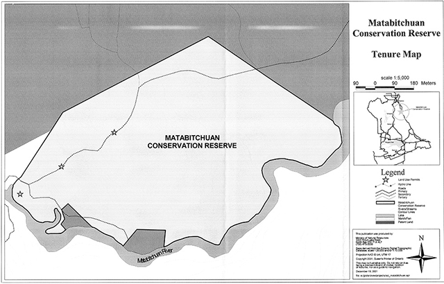
Two seasonal dwellings are found on patent parcels along the southern boundary of the conservation reserve. These patents are excluded from the reserve (see Tenure Map).
A Land Use Permit (LUP) is found within the southwestern section of the conservation reserve and supports a private recreational camp.
Mining claims and leases do not exist within the conservation reserve, but do exist in the surrounding area.
The hydroelectric generating station is held under a Water Power Lease Agreement (WPLA) and requires routine maintenance.
There is no other form of tenure in the conservation reserve other than legal agreements with registered fur trappers, bear management area operators and baitfish licensees.
Traditional uses within the conservation reserve will continue to be permitted; however, the goal will be to resolve conflicts regarding incompatibility between uses and to ensure that identified values are adequately protected. Existing uses are as defined in Section 5.2(a).
A motorized vehicle trail transects the northern portion of the conservation reserve and follows the secondary road identified on the Commercial Activities Map.
5.7. Commercial use
Present commercial use activities are illustrated in the Commercial Activities Map. Portions of one registered fur trapline and one Bear Management Area cover the conservation reserve.
5.8. Tourism/recreation use/opportunities
Current uses of this conservation reserve have been described in Section 5.1.1 (e). Presently, there is no known infrastructure supporting any recreational or commercial activity within the conservation reserve boundaries.
During the planning phase for the conservation reserve, no new recreational, ecotourism or tourism initiatives were brought forward for consideration.
5.9. Client services
Presently, client services include district responses to public inquiries. No formal information or interpretive facilities currently exist within the conservation reserve.
6.0 Management guidelines
6.1. Management planning strategies
Commitments identified in previous planning documents (TLUP and current policy (3.03.05 PLA) will form the basis for land use decisions within the conservation reserve. Management strategies for these uses must consider the short and long-term objectives for the conservation reserve. For up to date information on permitted uses refer to the Crown Land Use Atlas.
Proposed uses and development will be reviewed on a case-by-case basis. A Test of Compatibility, (Procedural Guideline B - Land Uses (PL 3.03.05) must be passed before they are deemed acceptable. The emphasis will be on ensuring that the natural values of the conservation reserve are not negatively affected by current and future activities. Therefore, any application for new specific uses will be carefully studied and reviewed. The Ministry, partner organizations and/or proponents may undertake such studies.
6.2. State of the resource management strategies
The development of this SCI and the long term management and protection of the Matabitchuan River Conservation Reserve will be under the direction of the MNR's North Bay District, Temagami Area Supervisor. The following management strategies have been created to achieve the goals and objectives stated earlier in this stewardship document.
Social/economic
- Management direction will aim to maintain and develop social and economic benefits to the local community where practical
- Local partnerships may be solicited to participate in the delivery of certain objectives identified in this SCI
- Educational opportunities will be developed and encouraged in order to create an awareness of natural systems in the area
Natural heritage stewardship
- With the exceptions of fire suppression and selected forest pest and disease control, the management intent for the Matabitchuan River Conservation Reserve is to allow for natural ecosystems, processes and features to operate undisturbed with minimal human interference while providing educational, research and recreational activities
- Forest ecosystem renewal and maintenance as stated for this conservation reserve under the TLUP will only be entertained via a separate vegetative management plan
- All wildfire occurrences will be considered a high priority and will actively be suppressed until such time as policy directions change
- Prescribed burning will be conducted only under the direction of the provincial fire strategy and authorized for the conservation reserve under a separate vegetative management plan. Prescribed burning may be utilized if deemed necessary to emulate natural disturbances and renew forest communities, prepare seed beds for research and/or education purposes or to meet additional objectives determined within a separate vegetative management plan
- All earth and life science features will be protected by defining compatible uses, enforcing regulations and monitoring and mitigating issues
- Industrial activities such as; commercial timber harvest, prospecting and mining and new hydro generation will not be permitted within the conservation reserve
- Permits for fuel-wood will not be issued
- New energy transmission, communication and transportation corridors or resource roads or construction of facilities are discouraged within the boundaries of the conservation reserve
- Other activities that do not pass a Test of Compatibility will be prohibited (MNR Policy 3.03.05, 1997)
- The introduction of exotic and/or invasive species will not be permitted
- Programs may be developed to control forest insects and diseases where there is a concern that significant values may be compromised. Remedies must focus on the outbreak or infestation. Biological or non-intrusive solutions should be applied whenever possible. Vegetation maintenance of the existing utility corridor should be encouraged to follow this process where and when feasible
- The collection/removal of vegetation and parts thereof will not be permitted; however, subject to a Test of Compatibility, the Area Supervisor may authorize the collection of plants and/or parts for purposes of rehabilitating degraded sites within the conservation reserve, collecting seeds for maintaining genetic stock and/or research
- Detailed ecological surveys concerning ground vegetation and additional plant values assessment-especially concerning species at risk is warranted. Additional plant science inventory should be linked to future recreational needs and possibly regional gap analysis approaches. Assessments should follow future direction and methods established through MNR's Inventory, Monitoring and Assessment Reporting (IMAR) program (see section 6.4)
- MNR will provide leadership and direction for maintaining the integrity of this conservation reserve as a heritage estate
- Research, education and interpretation will be encouraged to provide a better understanding of the management and protection of the natural heritage values and will be fostered through local and regional natural heritage programs, initiatives and partnerships
Fisheries and wildlife
- Fish and wildlife resources will continue to be managed in accordance with policies and regulations prevailing in the area and under the direction of the Temagami Area Supervisor. Provincial legislation and policy will dictate management and enforcement objectives for this area
- Management direction will aim to verify species present, ecological function and habitat requirements
- Additional fish and wildlife population and habitat assessments, especially for species-at-risk, are warranted
- Any fish and wildlife inventory may require a regional gap analysis approach
- Inventories, assessments or monitoring programs should follow direction and methods established through MNR's IMAR program and be linked to district sustainability objectives and initiatives or future recreational needs. (see section 6.4)
- First Nation Treaty Rights will be respected (see Aboriginal Interests)
- Area of Concern (AOC) prescriptions for the protection of fish and wildlife values, developed for forest management purposes, will be used as a guide when considering proposed activities/developments in the conservation reserve
- The rehabilitation of damaged ecosystems will occur whenever possible (maintain bio-diversity)
Cultural heritage
- Protection of these values will be maintained
- Documented sites will be checked periodically for signs of degradation Additional sites will be documented as encountered
- Development, research and education proposals may be considered in accordance with the Test of Compatibility; Conserving a Future for our Past: Archaeology, Land Use Planning & Development in Ontario, Section 3 (MCzCR, 1997) and MNR's AOC Descriptions and Prescriptions (Cultural Heritage Resources) for the .1999-2019 Temagami FMP or its successor
- Research/education to provide a better understanding of the management and protection of cultural heritage values will be encouraged
Land use/existing development
- Existing land uses and development within the conservation reserve that conflict with the protection objectives (Test of Compatibility) will be identified and discontinued if impacts can't be mitigated. Similarly, uses in adjacent lands will be reviewed. If they are found to impact on the conservation reserve, mitigation measures will be explored
- There will be no new motorized trail development; however, non-motorized trail development may be permitted only if the activity passes a Test of Compatibility
Commercial use
- Existing commercial uses such as fur and baitfish harvesting and the operation of a bear management area will be monitored in order to ensure they do not unduly deplete natural resources and that they impose a minimal impact on the features identified for protection
- Trapline cabins will not be permitted within the conservation reserve
- Commercial enterprises offering eco-tourism experiences will be encouraged, providing these activities are of low intensity and are compatible with other uses Aboriginal Interests
- Aboriginal and treaty rights will continue to be respected throughout the management of this SCI. Any future proposal(s) and or decision(s) that have potential impact(s) on individual aboriginal values and or communities will involve additional consultation with the affected aboriginal groups
Tourism/recreation
- The earth and life science features and their protection, shall be the overall theme for tourism
- The conservation reserve should also be portrayed as providing backcountry experiences near an urban setting
- Main base tourism development (lodges) will not be permitted
- Conflict resolution between recreational uses will be a priority. This will be achieved by adhering to the objectives of this SCI with input from relevant user groups
- The level of safety and compatibility between activities will determine permitted uses (i.e., Test of Compatibility)
- Low-impact camping may be permitted along the waterways. Degradation of cultural heritage sites in particular will be monitored. If deemed necessary, camping may be prohibited at certain sites in order to protect these values
Client services
- Information regarding the Matabitchuan River Conservation Reserve may be delivered from different sources, however MNR will be the lead agency for responding to inquiries regarding access, permitted and restricted activities, values, and recreation opportunities
- A management agreement may be pursued with an appropriate partner to share responsibilities for information services and the delivery of other aspects of this Statement of Conservation Interest
6.3. Specific feature/area/zone management strategies
Presently there are no specific management strategies in place for sub-zones within the conservation reserve.
With the exception of fire suppression, the old growth pine ecosystem will be allowed to develop in a natural, undisturbed manner. Any change in management direction for the old growth areas will be addressed within a vegetative management plan.
If, during the course of conservation reserve monitoring it is deemed necessary to regulate access or uses in certain areas, management zones may be developed. These zones will facilitate permitted/restricted activities for the protection of certain features or to resolve conflicts between uses. Zone management will endeavor to compliment linkages to areas and uses outside the conservation reserve. The creation of management zones will require additional planning beyond this SCI, public consultation and an eventual plan amendment if accepted.
6.4. Promote inventory, monitoring and assessment reporting (IMAR), and research
There are many opportunities to study and explore the natural systems in the conservation reserve. Since there has been little interference from "outside influences", some features may be observed in a relatively undisturbed state.
Non-destructive research will be promoted as an asset for obtaining an understanding of the natural features and processes in the Matabitchuan River Conservation Reserve.
6.5. Implementation and plan review strategies
This Statement of Conservation Interest will be reviewed on an ongoing basis. Implementation of the SCI will include monitoring activities to ensure adherence to management guidelines.
A full review will coincide with the review of the Temagami Land Use Plan_(next review - 2006) and will be done every ten years thereafter.
Implementation of this SCI and management of the conservation reserve are the responsibility of the Temagami Area Supervisor. Partnerships may be pursued to address management needs. If changes in management direction are needed at any time, the significance of the changes will be evaluated. Minor changes, which do not alter the overall intent of this SCI, may be considered and approved by the District Manager without further public consultation and the SCI will be amended accordingly.
In assessing major changes the need for a more detailed Resource Management Plan (RMP) will first be considered. Where a RMP is not considered necessary or feasible, a major amendment may be considered with public consultation. Such amendments will also be posted on the Environmental Bill of Rights (EBR) registry. The Regional Director has approval authority for any major amendments to this SCI.
6.6. Marketing strategies
Messages should focus on the conservation reserves accessibility, natural heritage representation and recreational opportunities. Research and education is a theme that should be incorporated into all promotional strategies.
Partnerships may be fostered to aid in the delivery of this component.
References
Crins, W.J. and P.W.C. Uhlig. 2000. Ecoregions of Ontario: Modifications to Angus Hills' Site Region and Districts - Revisions and Rationale.
Hills, G.A. 1959. A Ready Reference to the Description of the Land of Ontario and its Productivity. Ontario Department of Lands and Forests, Division of Research, Maple, Ontario. 140 pp.
Kor, P.S.G. 2001. Earth Science Checksheet: Matabitchuan River Conservation Reserve.
Noble, T.N. 1983. Life Science Report for Site Region 4E. Ontario Ministry of Natural Resources, Sudbury, 90 p. Appendices. 4E Biophysical Map Sheets (1:250,000).
Ontario Ministry of Natural Resources. 1997. Public Lands Directive Manual: Natural Heritage - PL 3.03.05.
Ontario Ministry of Citizenship, Culture and Recreation. 1997. Conserving a Future for Our Past: Archaeology, Land Use Planning and Development in Ontario. 42 pp.
Ontario Ministry of Natural Resources. 2001. A Draft Environmental Assessment for MNR Resource Stewardship and Facility Development Projects. 76 pp.
Ontario Ministry of Natural Resources. 1999. Forest Resource Inventory (FRI) Mapping: Matabitchuan River. Ontario Ministry of Natural Resources, North Bay.
Ontario Ministry of Natural Resources. 1997. Temagami Land Use Plan for the Temagami Comprehensive Planning Area.
Ontario Ministry of Natural Resources. 1991. Temagami Comprehensive Planning Program (Heritage Component)- Preliminary Review of Heritage Resources.
Ontario Ministry of Natural Resources. 1987. Assessment of Representative and Special Earth Science Resource Features of the Temagami Planning Area. Volume 2.
Roberts, S.K. 2001. Recreational Inventory Checksheet: Matabitchuan River Conservation Reserve.
Rowe, J.S. 1977. Forest Regions of Canada. Canadian Forest Service Publication No. 1300 171 pp.
Thompson, J.E. 2000. Aerial Reconnaissance Survey: Matabitchuan River Conservation Reserve.
Thompson, J.E., M. Lajeunesse, J. Joyce and N. Avoledo. 2001. Life Science Checksheet: Matabitchuan River Conservation Reserve.
Appendix A
Procedural guideline B - land uses Test Of Compatibility
Public Lands Act Policy PL 3.03.05 (procedure 3.03.05)
The Conservation Reserve policy provides broad direction with regard to the permitted uses. The policy provides only an indication of the variety of uses that will be considered acceptable in Conservation Reserves. The only caution is that "any new uses, and commercial activities associated with them will be considered on a case by case basis, they must pass a test of compatibility to be acceptable". What does a "test of compatibility" mean?
An examination of this must start from the premise of why an area is set aside - specifically, its representative natural heritage values. Criteria are then identified to guide compatibility considerations. These criteria apply to the long term acceptability of both existing uses and new uses.
-
Conformity to SCI: SCI describe values for which an area has been set aside and the range of appropriate uses that will be permitted in the area. SCI may also speak to the acceptability of other "new" uses currently not occurring in the area.
The first "test" is: "do proposed new land uses and/or commercial activities conform to the direction of the SCI for the Conservation Reserve? Would the new use(s) depart from the spirit of appropriate indicator land uses in the SCI?"
- Impact Assessment: If the proposed use(s) pass test one it is important to determine their impact on the area before they are approved. This should include the following:
- Impact on natural heritage values: "will the new use(s) impact any natural values in the area? If so, how and to what degree? Is it tolerable?"
- Impact on cultural values: "will the new use(s) impact any historical or archaeological values in the area?"
- Impact on research activities: "will the new use(s) affect any research activities in the area?"
- Impact on current uses: "will the new use(s) have any negative impact on the array of current uses?"
- Impact on area administration: "will the new use(s) increase administrative costs and/or complexity?" (For example, the cost of area monitoring, security and enforcement).
- Impact of accommodating the use outside the Conservation Reserve: "Could the use(s) be accommodated as well or better outside the Conservation Reserve?"
- Impact on socio-economics of the area: "will the use(s) affect the community(ies) surrounding the area in a positive or negative way?" (for example, will the new use make the area less remote thereby affecting a local tourism industry that is dependent on the area’s remoteness for its appeal)?
- Impact on area accessibility: "does the new use(s) give someone exclusive rights to the area or a portion of the area to the exclusion of other existing uses?"
Appendix B
Glossary of terms
Annual Work Schedule: one-year schedule of forestry operations (i.e. harvest, renewal, tending, road planning etc.)
Ecotourism: responsible tourism that considers the natural heritage values within the conservation reserve and their sustainability as well as taking into account the interests of local communities.
Fen: peatland with water table at or above the surface with very slow water movement through communities via seepage that results in a more mineral, nutrient and oxygen-rich environment than bogs. Generally fens contain peat accumulations greater than 40 cm deep. Sometimes floating mat with sedges, mosses, shrubs and sparse tree layer present. Indicator plants include; Larch (Larix Jaricina) and Eastern White Cedar (Thuja occidenta/is) over Black Spruce (Picea mariana), Speckled Alder (Alnus incana), Dwarf Birch (Betula pumila), Bluejoint Grass (Calamagrostis canadensis), assorted sedges, Sweet Gale (Myrica gale) with ericaceous shrubs present-especially in more nutrient poor fens (Harris et al.1996).
Poor fen wetlands generally contain greater amounts of black spruce than cedar and larch as well as ericaceous shrubs and sphagnum or peat mosses.
IMAR: An integrated, ministry-wide framework for Inventory, Monitoring, Assessment, and Reporting that supports the management of our natural resources in an ecologically sustainable way.
Land Caution: Regulation that was adopted sometime in August 1973 that prevented the first registration of title on Crown Land. The land caution was lifted in 1996.
Maps
Map 1: Location map
Map 2: Forest values
Map 3: Recreational values
Enlarge map 3: recreational values
Map 4: Fish and wildlife values
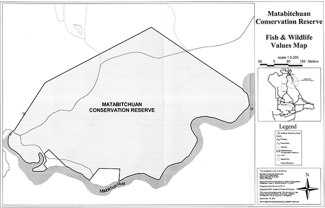
Enlarge map 4: Fish and wildlife values
Map 5: Cultural heritage values
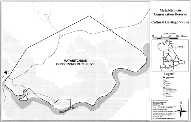
Enlarge map 5: Cultural Heritage Values
Map 6: Tenure map
Map 7: Commercial activities