Moon River Conservation Reserve Management Statement
This document provides policy direction for the protection, development and management of the Moon River Conservation Reserve and its resources.
Statement of Conservation Interest
March 2005
Ministry of Natural Resources
Parry Sound District
Prepared with the assistance of:
Meteek & Company
Huntsville, Ontario
Approval statement
We are pleased to approve this Statement of Conservation Interest for Moon River Conservation Reserve (C94) and Lower Moon River Conservation Reserve (C90). Together these two conservation reserves provide protection for approximately 15 kilometres of diverse habitats along the Moon River, from just west of Highway 400 (formerly Highway 69) to Arnolds Bay and The Massasauga Provincial Park on the Georgian Bay shoreline.
Moon River Conservation Reserve (C94) is the upstream component of these two protected areas. It consists of 457 hectares of Crown land, located in southern Freeman Ward in the Area Municipality of Georgian Bay, in the District of Muskoka. The site is approximately seven kilometres southwest of the hamlet of Mactier. At its closest point on the east it is about ½ kilometre west of Highway 400, and it abuts Lower Moon River Conservation Reserve at its west boundary.
This conservation reserve, located in Hills' ecological Site District 5E-7, includes steep rocky slopes and low cliffs on the Moon River. The surrounding uplands support representative sugar maple and old hemlock forests growing on gently sloping hills with shallow sandy soils or bare bedrock. It provides habitat for the nationally threatened eastern Massasauga rattlesnake and the threatened eastern hog-nosed snake.
Lower Moon River Conservation Reserve (C90) is a 2723 hectare area of Crown land, located about 10 kilometres due west of the hamlet of Mactier. The northern portions are in Conger Ward in the Township of The Archipelago in the Territorial District of Parry Sound. The southern portions are in Freeman Ward in the Area Municipality of Georgian Bay in the District Municipality of Muskoka. The northern boundary of this conservation reserve extends to the south shores of Healey Lake. To the southeast, it abuts Moon River Conservation Reserve, and to the west, it is within ½ kilometre of The Massasauga Provincial Park.
Lower Moon River Conservation Reserve, also located in Hills' ecological Site District 5E-7, contains a scenic portion of the Moon River between Curtain Chute and Moon Falls, and a large area of upland forests. The southern portions of the conservation reserve, in the vicinity of the Moon River, have been identified as a Muskoka Heritage Area. This area contains a variety of low cliff, bedrock slope and talus slope habitats and diverse shoreline flora, typical of the Georgian Bay landscape. The shoreline contains spawning habitat for muskellunge and walleye. This site protects numerous nationally and provincially rare wildlife and plants.
Moon River Conservation Reserve and Lower Moon River Conservation Reserve are two of 378 new protected areas approved through Ontario’s Living Legacy Land Use Strategy, aimed, in part, at completing Ontario’s system of parks and protected areas. They are part of the Great Lakes Heritage Coast, a signature site identified through Ontario’s Living Legacy Land Use Strategy. The Great Lakes Heritage Coast is designed to protect the coastal environment and provide for recreational and tourism opportunities associated with the natural environment.
These conservation reserves are within the Georgian Bay Littoral Biosphere Reserve, which was recently designated by the United Nations Educational, Scientific and Cultural Organization. This designation "represents a common vision of sustainable development and environmental and cultural conservation" by a wide range of stakeholders of the area (UNESCO, 2004).
During the "Lands for Life" planning process, the public was widely consulted and provided valuable input into what became Ontario’s Living Legacy Land Use Strategy. Comments received during that time and during consultation related to the formal Public Lands Act regulation of the boundaries of these conservation reserves, were generally supportive of the protection of these areas. Stakeholders who provided comment during the earlier consultation for these sites were subsequently consulted regarding the draft Statement of Conservation Interest and any comments were considered in the finalization of this document.
This Statement of Conservation Interest provides guidance for the management of the two conservation reserves and provides the basis for the ongoing monitoring of activities. More detailed direction is not anticipated at this time. Should more complex resource management or conservation issues arise or significant facility development be considered, then a detailed Resource Management Plan will be prepared with full public consultation.
Moon River Conservation Reserve and Lower Moon River Conservation Reserve are managed under the direction of the District Manager and the Parry Sound Area Supervisor of the Ministry of Natural Resources, Parry Sound District.
Approved by:
R. Griffiths
District Manager
Parry Sound District
Approved by:
Ron Running
Regional Director
Southern Region
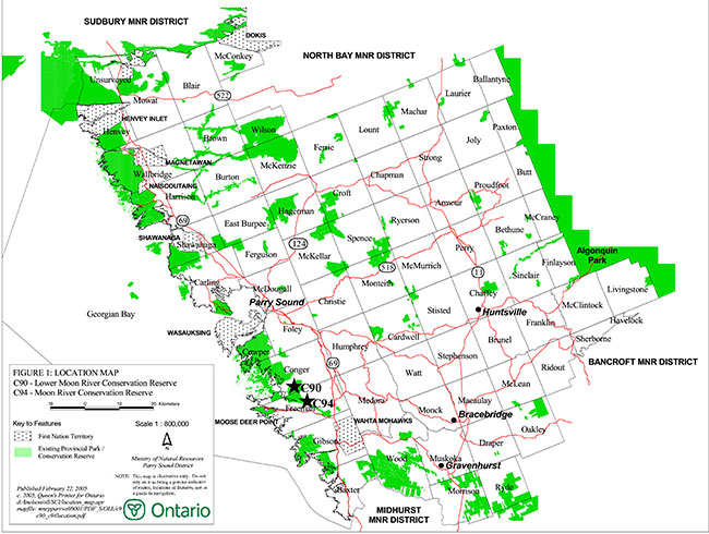
Figure 1: Location of Moon River Conservation Reserve (C94) and Lower Moon River Conservation Reserve (C90)
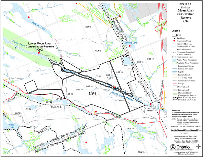
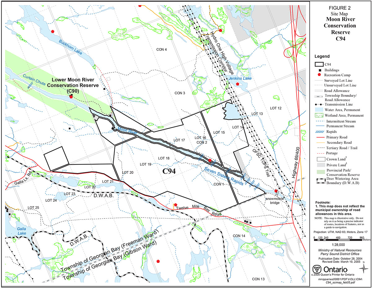
Figure 2: Site Map – Moon River Conservation Reserve (C94)
Enlarge Figure 2: Site Map – Moon River Conservation Reserve (C94)
Figure 3: Site Map – Lower Moon River Conservation Reserve (C90)
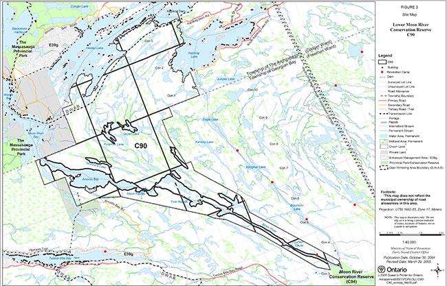
Enlarge Figure 3: Site Map – Lower Moon River Conservation Reserve (C90)
1.0 Introduction
Ontario’s Living Legacy, the result of an extensive planning process that began in early 1997, culminated in the approval in July 1999 of a Land Use Strategy that identifies the intended strategic direction for Crown land in central and northern Ontario, including the completion of Ontario’s system of parks and protected areas. This process, which included public consultation, resulted in the recommendation for regulation of 378 new protected areas, including Moon River Conservation Reserve (C94) and Lower Moon River Conservation Reserve (C90).
Moon River Conservation Reserve (C94) is the upstream component of these two protected areas. It consists of 457 hectares of Crown land, located in southern Freeman Ward in the Area Municipality of Georgian Bay, in the District of Muskoka. The site is approximately seven kilometres southwest of the hamlet of Mactier. At its closest point on the east it is about ½ kilometre west of Highway 400, and it abuts Lower Moon River Conservation Reserve at its west boundary.
Lower Moon River Conservation Reserve (C90) is 2723 hectare area of Crown land, located about 10 kilometres due west of the hamlet of Mactier. The northern portions are in Conger Ward in the Township of The Archipelago in the Territorial District of Parry Sound. The southern portions are in Freeman Ward in the Area Municipality of Georgian Bay in the District Municipality of Muskoka. The northern boundary of this conservation reserve extends to the south shores of Healey Lake. To the southeast, it abuts Moon River Conservation Reserve, and to the west, it is within ½ kilometre of The Massasauga Provincial Park.
Together, these two conservation reserves protect a scenic portion of the Moon River, from Highway 400 in the east, to Arnolds Bay and The Massasauga Provincial Park on the Georgian Bay shoreline in the west. In addition, Lower Moon River Conservation Reserve includes a large area of shallow-soiled bedrock plain extending northward from Moon River to the south shore of Healey Lake and the west shore of Kapikog Lake. These conservation reserves provide representation of a variety of upland forests, gently sloping hill, low cliff, bedrock slope and talus slope habitats and diverse shoreline flora, in ecological Site District 5E-7, typical of the Georgian Bay landscape. Together they protect numerous nationally and provincially rare wildlife and plants.
The southern portions of Lower Moon River Conservation Reserve, in the vicinity of the Moon River, have been municipally identified as a Muskoka Heritage Area.
The Moon River is a popular traditional canoe route from Bala to Woods Bay. Several campsites along the river support this use. The river also provides angling for warm water fish species, including walleye. Moon Falls, near the west end of Lower Moon River Conservation Reserve is a popular scenic site, with powerboat access from Arnolds Bay. It also provides for camping, swimming, picnicking, mooring, and fishing for muskellunge.
Hunting is a long-standing activity in both conservation reserves.
These conservation reserves are within the Georgian Bay Littoral Biosphere Reserve, which was designated by the United Nations Educational, Scientific and Cultural Organization on October 29, 2004. This biosphere reserve covers the eastern coast of Georgian Bay, from Port Severn to the Key River, and extends from roughly the middle of Georgian Bay inland more or less to Highway 69/400. This designation "represents a common vision of sustainable development and environmental and cultural conservation" by a wide range of stakeholders of the area (UNESCO, 2004).
Conservation reserves are established under the authority of the Public Lands Act, Ontario Regulation 805/94. Lower Moon River Conservation Reserve (C90) was established by Ontario Regulation 86/01 on April 21, 2001. Regulation of Moon River Conservation Reserve (C94) is in progress at the time of preparation of this Statement of Conservation Interest, and it is expected to be regulated in 2005.
A Statement of Conservation Interest (Statement of Conservation Interest) is prepared under the direction of Procedural Guideline A – Resource Management Planning (PL. Procedure 3.03.05). The purpose of this Statement of Conservation Interest is to identify and describe the values of Moon River Conservation Reserve (C94) and Lower Moon River Conservation Reserve (C90). The Statement of Conservation Interest also outlines the activities that currently occur within the conservation reserves and provides guidelines for the management of current and future activities in the context of protecting the natural, recreational and cultural values.
1.1 Background information:
| Name | Moon River Conservation Reserve (C94) Lower Moon River Conservation Reserve (C90) |
|---|---|
| Site Region/District | Georgian Bay Site Region, Site District 5E-7 |
| OMNR Administrative Region/District/Area | Southern Region/ Parry Sound District/ Parry Sound Area |
| Total Area (ha.) | C94 - 457 hectares C90 – 2723 hectares |
| Regulation Date | C94 – pending C90 – April 21, 2001 (O. Reg. 86/01) |
| First Nations | Robinson-Huron Treaty and Williams Treaty |
| OBM map sheets | C94 - 10 17 5900 49900 C90 - 10 17 5800 49900, 5800 49950, 5800 50000, 5850 49900, 5850 49950, 5850 50000, 5900 49900 |
| Topographic Map | Lake Joseph 31 E/4 |
| UTM co-ordinates | C94 - 17T 59298 499138 (Centroid) C90 - 17T 58460 499720 (Centroid) |
1.2 Representation
Earth science representation:
Moon River Conservation Reserve (C94)
Bedrock
- The Moon River Gneiss Association and an anorthosite unit, both of the Moon River Domain, Parry Sound Terrane, Central Gneiss Belt of the Proterozoic Grenville Province are represented in this conservation reserve
Surficial
- Bedrock plain overlain by discontinuous till characterize this site
Lower Moon River Conservation Reserve (C90)
Bedrock
- Similarly, this site represents the Moon River Gneiss Association, and an anorthosite unit of the Moon River Domain
Surficial
- Minor discontinuous drift over bedrock, with organic deposits in low-lying areas, and evidence of glacial erosional features typify this site
Life science representation:
Moon River Conservation Reserve (C94)
This conservation reserve represents a selection of older hemlock forests and young sugar maple – yellow birch forests on ground moraine, along with a section of the Moon River corridor with its associated shoreline communities.
Lower Moon River Conservation Reserve (C90)
Lower Moon River Conservation Reserve represents a selection of extensive hemlock forests (some with a component of white pine) and mixed hemlock – red oak – white pine forests, along with Atlantic Coastal Plain meadow marshes and significant river shoreline and aquatic communities on ground moraine; along with extensive open and shrub rock barrens, white pine – red maple woodlands, sugar maple –oak – basswood forests, and a variety of bog fen, thicket swamp and shoreline meadow marsh communities on bedrock plain.
Cultural sesources representation:
Neither detailed cultural research nor inventory has been carried out for either conservation reserve.
Recent regional evaluation (OMNR, 2003) shows that these conservation reserves contain areas that have a high potential for cultural heritage sites. There are a number of known registered cultural sites in the vicinity of these conservation reserves, most downstream of the sites along the shoreline of Georgian Bay, but one within Lower Moon River Conservation Reserve, and others upstream, on the Moon River and near Bala.
Recreational opportunities:
Recreational inventory reports were prepared for these sites based on existing knowledge and data sources of MNR staff, as well as site visits (Larson, 2004). The Moon River is a traditional canoe route passing through both conservation reserves. Lower Moon River Conservation Reserve is also accessible by power boat from Georgian Bay to the base of Moon Falls. Crown land camping occurs at sites along the river, and below Moon Falls. Both sites are used for a variety of hunting activities, and angling for a variety of fish species occurs throughout both sites. Snowmobiling, all-terrain vehicle travel, cross-country skiing and snowshoeing occur in both sites, mostly on unauthorized trails and old logging roads and trails.
1.3 Survey work
| Survey Level | Earth Science | Life Science | Cultural | Recreational | Other |
|---|---|---|---|---|---|
| Reconnaissance | Blackburn, 2003 a & b | Jalava, 2001 a & b | OMNR, 2003 | Larson, 2004 a & b | None |
| Detailed | None | None | None | None | None |
| Requirement | None | Monitor the status/presence of significant species and associations. | Research to be encouraged | Monitor use impacts | None |
2.0 Values to be protected
These conservation reserves are located entirely within Hills' (1959) ecological Site District 5E-7. Values include earth science, life science and recreational/aesthetic values, with an emphasis on the life sciences.
2.1 Earth science:
(Earth science information, unless otherwise noted, is taken from Blackburn, 2003a&b)
Bedrock:
Moon River Conservation Reserve (C94) represents one of two gneiss associations of the Moon River Domain, Parry Sound Domain, Central Gneiss Belt of the Proterozoic Grenville Province, along with a small anorthosite unit.
The Grenville Province is the product of thrusting and imbrication of the crust to the northwest as it collided with a continental landmass to the southeast. The Grenville Orogeny, circa 1140 to 1070 million years ago, culminated more than 500 million years of crustal evolution. The eroded roots of the products of these events are displayed in the complexly metamorphosed and deformed rocks of the region (Easton, 1992b).
The Parry Sound Terrane is one of the four lithotectonic terranes of the Central Gneiss Belt. The Moon River Domain is one of three structural domains of the Parry Sound Terrane. This geological environment is part of the modern organization of the complex products of the mid-Proterozoic orogenic events (Easton 1992a & b). As such, their representation in Moon River Conservation Reserve contributes to the conservation of the Grenville Province continental accretion theme (Davidson, 1981).
The Moon River Domain consists of 1.45 to 1.35 million-year-old gneisses and migmatites of supracrustal and igneous origin. The Moon River Domain has been divided into two gneiss associations primarily based on rock type, but also separated by a narrow continuous sliver of anorthosite that has been ascribed to the Parry Sound Domain. This site appears to be underlain by rocks of the Moon River gneiss association, with a sliver of the anorthosite appearing in the southwest corner of the site. Moon River gneiss association rocks observed consist of grey biotite-hornblende gneiss and pink leucogneiss. Anorthosite observed is massive to gneissic, with amphibolite and grey gneiss inclusions. Metamorphic grade of the Moon River Domain is retrograded from granulite to amphibolite facies.
Within the Ontario Provincial Park system, the bedrock geological features of Moon River Conservation Reserve have local significance in the representation of Moon Island gneiss association of the Moon River Domain, Parry Sound Terrane. However, the presence of the small area of anorthosite in the southwest corner of the site raises the site to regional significance.
Lower Moon River Conservation Reserve (C90) also represents the Moon River gneiss association of the Moon River Domain, although its significance is higher than in the smaller Moon River Conservation Reserve.
Moon River gneiss association rocks underlie almost all of the conservation reserve, which lies on the face of a major synform, and extends along its south limb. Rocks of the association are orthogneiss, voluminous pink leucogneiss and minor supracrustal rocks (Easton 1992a). At Moon Falls, where Moon River flows into Arnolds Bay, a grey granodiorite to tonalite orthogneiss has been tightly folded into multiple, shallow plunging folds that plunge at a shallow angle towards the east-southeast, along the strike of the Moon River syncline.
The anorthosite sliver that separates the two gneiss associations of the Moon River Domain occurs in a very small corner at the southwest corner of this site, just south of Arnolds Bay.
The exposure of bare bedrock along the Moon River and a complexity of geological features contribute to the high significance of this site in the earth science conservation program. The best examples of the geology of the Moon River Domain within protected lands are preserved along this shoreline. They contribute to understanding of the history of development of the Proterozoic Grenville Province. For these reasons, the geology of this site is assigned provincial significance.
Surficial:
Both conservation reserves lie in the Georgian Bay fringe physiographic region of Southern Ontario, a broad belt bordering Georgian Bay characterized by very shallow soil, and bare rock knobs and ridges (Chapman & Putnam, 1984). Bedrock plain overlain by shallow till characterize Moon River Conservation Reserve (C94), with minor discontinuous drift over bedrock, glaciofluvial outwash and valley-fill sand and gravel and recent organic deposits also found. Lower Moon River Conservation Reserve (C90) is characterized by bedrock ridges with minor discontinuous drift, with recent organic deposits in low-lying areas. Glacial erosional features are also in evidence.
The surficial geology of Moon River Conservation Reserve (C94) is not considered significant. The influence of bedrock structure on subsequent physiography is well represented in Lower Moon River Conservation Reserve, in this case the nose and south limb of the Moon River synform. It is one of the best examples within Ontario’s protected areas system, and is given provincial significance.
2.2 Life science:
These conservation reserves are a part of a discontinuous band of granite barrens extending from the Kaladar area in Eastern Ontario to Georgian Bay up to and including the French River. These granite barrens present a distinctive habitat type within Southern Ontario with unique environmental factors and specialized plants and animals. As they have limited occurrence in Southern Ontario, granite barrens warrant protection. (Catling, Brownell, 1999).
Moon River Conservation Reserve (C94)
(Life science information, unless otherwise noted, is taken from Jalava, 2003a)
Moon River Conservation Reserve, in Hills' ecological Site District 5E-7, was selected as a candidate area for protection during the natural heritage gap analysis process associated with "Lands for Life", a precursor to Ontario’s Living Legacy. The purpose of the gap analysis was to identify different vegetation and landform combinations that were not presently included in protected areas. Geographic Information Systems (GIS) technology was used and applied to the following criteria:
- representation of landform-vegetation patterns
- diversity
- condition
- ecological considerations; and
- special features (Crins and Kor, 1998)
Representation:
Moon River Conservation Reserve protects a diverse 457 hectare tract of the Moon River corridor immediately west of Highway 400. It consists primarily of hemlock (Tsuga canadensis) and sugar maple (Acer saccharum) forests with scattered small shoreline communities, wetlands and patches of open rock barren. This section of the Moon River has several sets of rapids, and steep valley slopes consisting of sandy till. The site is located within the "weakly broken sandy till plain (bare bedrock)" biophysical unit (Ia-11) (Noble 1983).
The predominantly upland vegetation types are fresh-moist sugar maple - yellow birch (Betula alleghaniensis) deciduous forests, which cover approximately one third of the site, and hemlock – hardwood, mixed and hemlock coniferous forests, which cover another third of the site. Many of the sugar maple – yellow birch forests have been logged in recent decades, and have abundant seedlings and saplings of the dominant species. American beech (Fagus grandidendata) and hemlock often occur as secondary dominants or associates in these forests. Common understory species in the sugar maple forests include striped maple (Acer pensylvanicum) and hobble bush (Viburnum lantanoides), with wood ferns (Dryopteris spp.), yellow adder’s-tongue (Erythronium americanum), wild lily-of-the-valley (Maianthemum canadense), Indian cucumber (Medeola virginica), and wild sarsaparilla (Aralia nudicaulis) in the herbaceous layer. The locally rare dwarf ginseng (Panax trifolius) is found in patches in this community.
Hemlock forests are predominant on the river valley slopes, and are also common on north facing ground moraine slopes. Sugar maple and beech are often co-dominant species in mixed hemlock stands. Hemlock stands typically have a sparse understory. Small scattered patches of open rock barren are found in the southern half of the site; these are dominated by crinkled hairgrass (Deschampsia flexuosa).
Several wetlands occur in poorly drained depressions in this site, including: a small hemlock – white pine (Pinus strobus) conifer swamp in the southwest portion of the site; part of a red maple (Acer rubrum) – hemlock – white pine – yellow birch – tamarack (Larix laricina) coniferous swamp which extends into the southwest end of the site; two red maple swamps, one on a mineral near the west end of the site, and the other on organic soils at the southeast end; and small meadow marshes and open water communities associated with beaver dams scattered in depressions in the ground moraine.
The Moon River valley has a narrow flood plain in several locations that supports a variable mosaic of mineral thicket swamps and meadow marsh communities, often over-topped by a narrow band of scattered red maple trees. Patches of open sand, gravel, stones and boulders are interspersed with herb meadows and low shrub thickets. Sweet gale (Myrica gale) is the predominant shoreline shrub. The provincially rare ridged panic grass (Panicum rigidulum) is found in some of the shoreline communities.
Condition:
Much of Moon River Conservation Reserve has been selectively logged in recent decades. Old logging trails and roads are evident in numerous locations, and are used by all-terrain vehicles and snowmobiles to access the site.
Moon River water levels are regulated for hydro-power generation, and the variation in shoreline water levels may have an impact on the structure of the Moon River shoreline and aquatic vegetation communities.
Diversity:
Moon River Conservation Reserve sustains 18 different vegetation community types (1 rock barren type, 6 forest types, and 11 wetland types) on one physiographic land form (Ia-11 weakly broken sandy till plain – bare bedrock). Based on 2001 fieldwork, the site provides habitat for at least 210 vascular plant species.
Ecological considerations:
This conservation reserve protects part of the significant Moon River valley corridor that connects the extensive natural areas of Georgian Bay shoreline to the interior natural areas of Muskoka.
Special features:
Moon River Conservation Reserve provides representation of three provincially and/or globally rare vegetation community types: sugar maple – beech – striped maple; hemlock mineral coniferous swamp; and buttonbush – sweet gale mineral thicket swamp. It contains three provincially significant species: ridged panic grass, Panicum rigidulum var. rigidulum, considered uncommon in Muskoka; hairy panic grass, P. villosissimum, previously undocumented in Muskoka; and red-shouldered hawk, Buteo lineatus.
Habitat for other provincially significant species exists within the site, and specimens have been documented within three kilometres of the site. These include: eastern Massasauga rattlesnake, Sistrurus catenatus catenatus; five-lined skink, Eumeces fasciatus; eastern hog-nosed snake, Heterodon platirhinos; and Hayden’s sedge, Carex haydenii.
Lower Moon River Conservation Reserve (C90)
(Life science information, unless otherwise noted, is taken from Jalava, 2003b)
Representation:
Lower Moon River Conservation Reserve protects a diverse 2,723 hectare tract of white pine, red oak, hemlock and sugar maple forests, vast rock barrens, a major river, as well as lakes, beaver ponds, and an array of fen, bog, swamp, marsh, meadow marsh, shoreline and aquatic communities. Ground moraine mantles the bedrock in the eastern portion of the site, while most of the northern and western sections of the conservation reserve are shallow-soiled bedrock plain. The site contains the final 11 kilometres of the Moon River, as well as the river’s outlet to the waters of Georgian Bay at Arnolds Bay. The site’s varied topography supports vegetation associations that are typical of the southern Georgian Bay portion of ecodistrict 5E-7, but some communities, such as those along the shores of the Moon River, are unique because of the site’s unusual combination of geological, topographic and microclimatic conditions. The steep, south-facing slopes of the northern shore of the Moon River and Arnolds Bay have a considerably warmer-than-normal microclimate.
Lower Moon River Conservation Reserve is located within two biophysical units (Noble 1983). The ground moraine portion of the site, which contains the Moon River corridor east of Moon Falls, is within the "weakly broken sandy till plain (bare bedrock)" landform, or biophysical unit Ia-11. The remainder of the site, from Arnolds Bay north to Healey and Kapikog lakes, is within the "weakly broken bare bedrock plain (organic)" landform, or biophysical unit VIIa-7. The site’s landform-vegetation patterns are described in the context of these two units.
Weakly Broken Sandy Till Plain (bare bedrock) (Ia-11)
Vegetation along the Moon River corridor in the ground moraine portion (unit Ia-11) of the conservation reserve follows a fairly distinct pattern. The faster flowing sections of the river are virtually unvegetated. Slower portions of the river with silty and sandy substrates support interesting and diverse aquatic communities dominated by white water-lily (Nymphaea odorata) - Robbins' spike-rush (Eleocharis robbinsii) and ribbonleaf pondweed (Potamogeton epihydrus). An emergent aquatic community of heart-leaved pickerelweed (Pontedaria cordata), with white water-lily and Small’s spike-rush (Eleocharis smallii) as associates, is also frequent near the shore in slow-moving water.
The Moon River shoreline has a fairly well developed, patterned series of shoreline communities, particularly on the floodplain in the 3 kilometre stretch upriver from Moon Falls. The river branches into two sections along what appear to be fault lines, forming two major linear bedrock-controlled islands, several smaller such islands, and a number of sand and gravel islands and bars that vary in size depending on water levels. The typical mosaic community on this floodplain consists of a band of sweet gale (Myrica gale) – buttonbush (Cephalanthus occidentalis) – northern dewberry (Rubus flagellaris) thickets, alongside meadow marshes dominated by royal fern (Osmunda regalis) and Canada blue-joint (Calamagrostis canadensis) and, in moister sections, Small’s spike-rush. The most established floodplain communities have an open canopy of red maple trees. The north side of the easternmost linear island has a more developed red maple – white birch – white pine tree layer, with an extensive winterberry tall shrub layer. a meadowsweet (Spiraea alba var. alba) low shrub layer, and a royal fern – blue-joint meadow marsh in the herb layer. The wettest, most-recently exposed shorelines and bars in one area along the lower portion of the north arm of the river, are dominated by crested sagittaria, (Sagittaria cristata), needle spike-rush (Eleocharis acicularis) and small waterwort (Elatine minima). Small’s spike-rush is dominant on drier, but still very moist, sections; while a wool-grass (Scirpus cyperinus) – bladder sedge (Carex vesicaria) – rough hair grass (Agrostis scabra) – aquatic sedge (Carex aquatilis) meadow marsh has become established on the upper shore.
Bedrock shorelines are also common, and are typically quite steep, with cracks and narrow ledges holding moisture and small amounts of soil. Herb growth is very sparse in these communities. The Atlantic Coastal Plain disjunct, ridged panic grass (Panicum rigidulum), is also common in sections of flatter bedrock, occurring with grass-leaved goldenrod, lance-leaved violet (Viola lanceolata) and other panic grasses (Panicum sp.), forming a newly-described, provincially rare vegetation type. Along the northern channel of the river, about 2 kilometres east of Moon Falls, there is an impressive west-facing open cliff with very sparse vegetation.
Immediately above the floodplain and bedrock shorelines, warm, rocky, south-facing slopes support savannah-like white pine – red oak – white oak woodlands, with a low shrub layer of common juniper (Juniperus communis) – lowbush blueberry (Vaccinium angustifolium). North-facing slopes and ridge tops along the Moon River corridor are covered in extensive dry – fresh hemlock – red oak – white oak – red maple mixed forests that grade into hemlock conifer forests in cooler, moister situations. Towering white pine trees are frequent secondary dominants in both the mixed and conifer forests, and white birch is also a common associate. The understorey in these hemlock-dominated stands is very sparse.
In addition to similar hemlock-dominated forest types, the eastern-most section of the Moon River corridor sustains other forest types that extend beyond the site into the adjacent Moon River Conservation Reserve. These include dry – fresh sugar maple – red oak deciduous stands on drier, upper slopes, and moist – fresh sugar maple – hemlock and hemlock – yellow birch stands on lower slopes. There is a rather unusual, moist red oak – red maple stand with an extensive American elm – beech – striped maple sapling layer in a linear depression above the north slope of the Moon River corridor.
Linear depressions north of the two channels of the Moon River support wetland and aquatic communities that are typical of the bedrock plain (biophysical unit VIIa-7) portion of the site, including mixed forb meadow marshes and water-shield (Brasenia schreberi) – white water-lily floating-leaved aquatic vegetation. These areas also support two communities not found elsewhere in the conservation reserve. These are an open fen dominated by white beaked-rush (Rhynchospora alba), with swamp willow-herb (Decodon verticillata) and marsh St. John’s-wort (Triadenum virginicum) as common secondary species, and a rare Atlantic Coastal Plain meadow marsh dominated by reed-like three-way sedge (Dulichium arundinaceum), a panic grass (Panicum cf. capillare) and Canada rush (Juncus canadensis). The provincially rare common meadow-beauty (Rhexia virginica) and Carey’s knotweed (Polygonum careyi) are common associates in the latter community.
Weakly Broken Bare Bedrock Plain (organic) (VIIa-7)
Weakly broken bedrock plain (biophysical unit VIIa-7) covers the remaining 75% of the conservation reserve to the west and north of Moon Falls. The extreme eastern limit of this unit includes an almost perfectly straight, linear bedrock shoreline at the confluence of the two branches of the Moon River described above. This bedrock feature extends for over 500 metres southwest and northeast of the confluence, but becomes buried by sandy soils in the northeastern portion, which forms the shoreline of a wide section of the river. The bedrock supports an Atlantic Coastal Plain bedrock meadow marsh community, dominated by the provincially rare ridged panic grass; the locally rare Canada wild onion (Allium canadense) is also common in this community. The area immediately surrounding Moon Falls has extensive bedrock shoreline, particularly during low water; it is very sparsely vegetated, with locally rare species such as small-headed beaked-rush (Rhychospora capitellata) and ninebark (Physocarpus opulifolius) present. To the northeast, where the bedrock is mantled by sandy substrate, a buttonbush thicket swamp has become established. A small, intermittent stream empties into the Moon River in this area, and its rich substrate provides conditions ideal for the development of a meadow marsh dominated by royal fern and sensitive fern (Onoclea sensibilis), along with a diversity of other forbs.
Below Moon Falls, water levels are influenced both by fluctuations of Lake Huron as well as the volume of water flowing down the Moon River. Sand and bedrock shorelines are extensive during low water periods. The open water of this area is not formally considered part of the conservation reserve. However, it should be noted that northern wild rice (Zizania palustris) mineral shallow marshes occur in several locations, in embayments of the final 1 kilometre stretch of the Moon River, as well as near the shores of Arnolds Bay. Sandy shorelines along the Moon River and Arnolds Bay support three-square Bulrush shallow marshes and mineral meadow marsh types dominated soft-stem bulrush (Schoenoplectus tabermontanae), needle spike- rush, wool-grass, brown-fruited rush (Juncus pelocarpus), northern St. John’s-wort (Hypericum mutilum ssp. boreale) and/or boneset (Eupatorium perfoliatum). The provincially rare Carolina yellow-eyed grass (Xyris difformis) occurs in one example of this community mosaic. Drier backshore sections are typically dominated by a band of aquatic sedge, meadow marsh and sweet gale thicket swamp. On the north side of the outlet of the Moon River to Arnolds Bay, there is a barrier beach that supports a fringe of speckled alder (Alnus incana) mineral thicket swamp with a sparse, fern-dominated herb layer. Behind the barrier beach is a relatively open slender willow thicket swamp with an extensive, marshy herb layer strongly dominated by lake-bank sedge (Carex lacustris), with beaked sedge (Carex utriculata) and aquatic sedge as secondary species.
The conservation reserve includes a narrow strip of land around a small bay south of Arnolds Bay. Upland communities include rock barrens with open-grown white pine and red oak woodlands. The extreme southwestern corner of the site supports deciduous and mixed forest stands dominated by red maple, red oak, hemlock and sugar maple. The narrow bay in this area sustains two meadow marsh types, dominated by aquatic sedge – lake-bank sedge, and by Small’s spike-rush – soft rush (Juncus effusus).
The remainder of the site, the bedrock plain that extends north from Arnolds Bay to Healey Lake, can be described as one unit. Extensive dry acidic rock barrens dominated by common juniper, with scattered copses of red oak and young white pine trees and saplings dominate the south-facing slopes above the north shore of Arnolds Bay, providing ideal habitat for the provincially uncommon prairie warbler. These shrub barrens extend far beyond the slopes onto the bedrock plain, particularly along the western boundary of the site, but appearing patchily throughout the northern half of the site. A substantial proportion of the barrens is open bedrock, dominated by crinkled hairgrass, eastern bracken fern, poverty oat grass (Danthonia spicata), large-leaved aster, wild lily-of-the-valley (Maianthemum canadense), reindeer lichen (Cladonia rangiferina) and haircap mosses (Polytrichum spp.), as well as occasional patches of lowbush blueberry.
White pine and red maple are the dominant tree species in the open mixed to coniferous woodlands that cover much of the bedrock plain north from Arnolds Bay to Healey Lake, with some stands strongly dominated by white pine. These forests are generally young, and are probably fire-successional. The northeastern fringe of the site (just west of Kapikog Lake) has slightly deeper sandy soils that support an extensive north-south band of dry – fresh sugar maple forests, with red oak and/or American basswood as common co-dominants. Areas of deeper till soil near the southeastern end of this biophysical unit support small hemlock-dominated mixed and conifer stands with a very sparse understorey. Moist-fresh red maple forests and red maple swamps occur throughout the unit where poorly-drained bedrock depressions have accumulated organic and weathered bedrock soils. Other forest communities occur as relatively small patches on the bedrock plain. These include occasional small red pine coniferous stands on dry sandy soils, a relatively rich sugar maple – yellow birch stand with moist loamy soil near Healey Lake, as well as copses of large-tooth aspen (Populus grandidentata) scattered in moister depressions on the open barrens.
The northwestern section of the site sustains a wide variety of wetland types that are typical of the southern Georgian Bay coastal area of the Canadian Shield. These include occasional small open bogs of Virginia chain fern (Woodwardia virginica) and leatherleaf (Chamaedaphne calyculata) shrub bogs in depressions on the open barrens. There is a black spruce treed bog near the centre of the bedrock plain section of the site that has white pine as a secondary dominant, and an extensive leatherleaf low shrub layer. Areas with some water flow, such as the fringes of small lakes, streams and beaver ponds, as well as a 2.5 kilometre long linear peatland-depression in the northwestern corner of the site, support various fen and shore fen communities. Leatherleaf is the ubiquitous dominant in these shrub fens, often with sweet gale as a secondary dominant, and occasionally with lowbush blueberry. A number of smaller open graminoid fens also occur along the shores and in depressions on the bedrock plain. These are usually dominated by beaked sedge, Virginia chain fern, silvery sedge, tawny cottongrass and/or prickly sedge (Carex echinata).
A variety of swamps, thicket swamps and meadow marshes occur where there are deeper organic deposits in bedrock depressions. These include the aforementioned red maple swamps and a small black ash (Fraxinus nigra) treed swamp with spotted touch-me-not (Impatiens capensis) and sensitive fern dominant in the herb layer. Numerous small speckled alder thicket swamps occur, often with a sphagnum moss layer and a Virginia chain fern herb layer. Buttonbush thicket swamps also occur along shorelines and in bedrock depressions, usually with a sparse herb layer often dominated by silvery sedge. Meadow marshes are frequent along organic muck shores of beaver ponds, streams and lakes in biophysical unit VIIa-7, with the most frequent dominant species being rice cut grass (Leersia oryzoides), Canada blue-joint, beaked sedge, wool-grass, swamp loosestrife (Lysimachia terrestris) and reed-like three-way sedge.
Condition:
Much of Lower Moon River Conservation Reserve shows little or no evidence of recent human disturbance. Interior sections of the site retain qualities of the pristine Georgian Bay coastal landscape of the past, with wilderness attributes. The diversity of the open water aquatic and shoreline communities, and the generally low populations of introduced species, are an indication of the high ecological quality of these communities in particular. These wetland and aquatic communities are habitat for the majority of significant plant and animal species found in Lower Moon River Conservation Reserve.
Fire was an important, naturally occurring factor in the successional cycle of the forests that occur on the bedrock-controlled northern and western portions of the site (biophysical unit VIIa-7). Some of the site’s forests have been selectively-logged, with timber extraction having occurred in the sugar maple forest just west of Curtain Chute at the site’s east end during the past two decades.
The Moon River water levels are regulated for hydroelectric power generation. Inundation of the riparian / floodplain communities is a natural occurrence; however the degree to which these communities are flooded, and the time of year in which it occurs, may differ as a result of the human control of the water levels. This may be impacting on the composition and structure of the Moon River shoreline and aquatic vegetation communities.
Diversity:
Lower Moon River Conservation Reserve sustains an outstanding diversity of 62 different vegetation community types on two biophysical units, which form 73 landform-vegetation types. Based on 2001 fieldwork, the site provides habitat for a high diversity of at least 414 vascular plants of which a high proportion (94%, or 388 species) are native to central Ontario. Seventy-one species of birds were observed at the site during the 2001 survey, with 68 of them showing evidence of breeding within the site. Twelve mammal species were documented, including such wide-ranging species as black bear, eastern wolf, coyote, fisher and moose. Seven reptile and 9 amphibian species were recorded as incidental observations. These include the threatened eastern Massasauga rattlesnake and the provincially rare to uncommon Blanding’s turtle.
Ecological considerations:
Lower Moon River Conservation Reserve protects a highly significant river valley corridor that connects the vast natural areas of the Georgian Bay coast to the interior natural areas of Muskoka. It forms a significant part of the greater Georgian Bay ecosystem. With a size of over 2,700 ha, the site provides habitat for wide-ranging mammals such as black bear, eastern wolf, coyote, moose and other notable mammal species, as well as a variety of area-sensitive bird species. The site protects a significant portion of the Moon River watershed, as well as the headwaters of numerous small streams that originate in the bedrock plain portion of the site. The conservation reserve protects approximately 6 kilometres of Georgian Bay shoreline at Arnolds Bay, as well as over 25 kilometres of the Moon River shore (including island shorelines). The site protects many tens of kilometres of inland lake shores, including stretches of Healey and Kapikog Lake shores, as well as numerous small inland lakes, ponds, streams, marshes and peatlands.
In addition to known walleye spawning in areas of the Moon River, the Upper Great Lakes Fisheries Management Unit has identified sturgeon (Acipenser fulvescens) spawning habitat in this area.
Special features:
The following vegetation types are considered globally rare to uncommon and/or provincially rare to uncommon by the NHIC:
VIIa-7 Common Juniper Acidic Shrub Rock Barren Type
Ia-11 Dry - Fresh Hemlock - Oak Mixed Forest
VIIa-7 Dry – Fresh Sugar Maple – Basswood Deciduous Forest Type
Ia-11, VIIa-7 Buttonbush - Sweet Gale Mineral Thicket Swamp Type
Ia-II Cottongrass - Beak-rush / Yellow-eyed Grass Open Fen
VIIa-7 Leatherleaf – Forb Deciduous Shrub Fen Type
VIIa-7 Leatherleaf - Chain Fern / St. John’s-wort Shrub Fen
VIIa-7 Virginia Chain Fern Open Bog Type
Ia-II, VIIa-7 Atlantic Coastal Plain Forb Bedrock Meadow Marsh Type
The following fifteen species are considered provincially significant and are found at Lower Moon River Conservation Reserve:
Dendroica discolor Prairie Warbler: The species frequents dry Common Juniper acidic rock barrens. This population has been known in the site since the early 1980's, when breeding was confirmed, and its presence was reconfirmed during the present study in 2001.
Sistrurus catenatus catenatus Eastern Massasauga Rattlesnake: COSEWIC-Threatened, MNR – Threatened. There are numerous records of the nationally and provincially threatened and globally rare eastern Massasauga rattlesnake for Lower Moon River Conservation Reserve and its surrounding area. The frequency and distribution of records and the presence of abundant suitable habitat from Healey Lake south to the Go Home Lake area suggests that there is a sizable, continuous population of this species in the area.
Emydoidea blandingii Blanding’s Turtle: During the 2001 site investigation, 11 individuals of this globally and provincially rare to uncommon species were discovered at four separate locations at the northeast end of Lower Moon Conservation Reserve, suggesting a sizeable population in the area. According to the Ontario Herpetofaunal Summary, there are numerous records of this species in the southern Georgian Bay coastal area (Oldham and Weller 2000).
Eumeces fasciatus Five-lined Skink: COSEWIC-Species of Concern, MNR-Species of Special Concern. There are three widely dispersed records of the provincially rare Five-lined Skink for Lower Moon Conservation Reserve area (NHIC 2001). There is abundant open rock barren habitat for Ontario’s only lizard species throughout the western portion of the site.
Heterodon platirhinos Eastern Hog-nosed Snake: Threatened, based on Species at Risk in Ontario List of April 2004, and COSEWIC. There is an August 1983 record of this provincially rare snake in the southwestern corner of Lower Moon River Conservation Reserve (NHIC 2001). The conservation reserve probably protects critical habitat for what is one of the key viable populations of eastern hog-nosed snake in the province.
Clemmys guttata Spotted Turtle: COSEWIC-Endangered, MNR-Species of Special Concern. There is a single historic (1971) record of this species for the "mouth of the Moon River" (NHIC 2001). The peatlands, small lakes and beaver ponds between Arnolds Bay and Healey Lake in the western portion of Lower Moon River Conservation Reserve are suitable habitat for this secretive turtle, but no individuals were observed during the present study.
Sternotherus ordoratus Stinkpot Turtle: COSEWIC – threatened. R. Black (MNR staff) reports a photograph taken of a pair of these turtles in the water along the shore of Arnold’s Bay, in 1987 or 1988.
Acipenser fulvescens Lake Sturgeon: Individuals of this globally and provincially rare fish were found at the outlet of the Moon River in Arnolds Bay and Moon River Bay in July 1980, but the species has not been reported at the site since.
Najas gracillima Thread-like Najas: A small population of this species [verification of collected specimens pending] was discovered in early September 2001 in a slow-moving section of the Moon River. Thread-like Najas is considered to be an indicator of good water quality. This species is considered rare in the district of Muskoka (Oldham 2001).
Xyris difformis Carolina Yellow-eyed Grass: Three small populations of Carolina yellow-eyed grass were discovered during the present study at separate locations within the site
Polygonum careyi Carey’s Knotweed: A population of over 100 flowering plants of this Atlantic Coastal Plain disjunct was discovered on the receded sandy shore of a small lake just north of the Moon River. Another 5 plants were found just south of this location.
Panicum rigidulum var. rigidulum Ridged Panic Grass: Ridged panic grass was found in generally small populations along the Moon River between Curtain Chute and Moon Falls. The largest population found consisted of 50 plants. This species is considered uncommon in the District of Muskoka (Oldham 2001).
Sagittaria cristata Crested Sagittaria: In September 2001, crested sagittaria was found to be growing abundantly, both submerged and stranded on silty-sand flats (where it was flowering) along the north arm of the Moon River. This species is considered uncommon in the District of Muskoka (Oldham 2001).
Triadenum virginicum Marsh St. John’s-wort: The provincially rare marsh St. John’s-wort was found at seven different locations in the bedrock plain portion of Lower Moon River Conservation Reserve. It was usually found to be associated with shore fens.
Rhexia virginica Common Meadow Beauty: A population of approximately 350 flowering common meadow beauty was found growing with Carey’s knotweed on the receded sandy shore of a small lake just north of the Moon River.
Viola X primulifolia (Viola lanceolata X Viola mackloskeyi) S1 (Hybrid): This extremely rare hybrid violet was found growing quite abundantly in one section of the Moon River floodplain meadow marsh community. This taxon is rare in the District of Muskoka (Oldham 2001), and there are fewer than five known occurrences in Ontario.
2.3 Cultural values:
While no specific cultural studies or inventories have been undertaken within these conservation reserves, and no major cultural resource values have been evaluated or identified to date, recent regional evaluation (OMNR, 2003) provides generalized broad-brush mapping which shows that these conservation reserves contain areas that have a high potential for cultural heritage sites. There are a number of known registered cultural sites in the vicinity of these conservation reserves, most downstream of the sites along the shoreline of Georgian Bay, but one within Lower Moon River Conservation Reserve, and others upstream, on the Moon River and near Bala.
It is probable that the Moon River was used as a travel corridor for First Nation people, fur traders, settlers and the early logging industry (Ontario Department of Lands and Forests, 1964).
2.4 Recreational/aesthetic values:
(Recreation information, unless otherwise noted, is taken from Larson, 2004a&b)
Moon River Conservation Reserve (C94) encompasses a 3 ½ kilometre stretch of the Moon River, which is a long-standing traditional canoe route. The river contains several rapids and chutes with associated portages, and several campsites are located along the steep shores. The water level of this stretch of river is controlled upstream by hydro-power generating stations, and it undergoes fluctuations that can drastically alter the difficulty level of the rapids. The Moon River is a scenic, unique feature with a high attraction capability within a two to three hour drive of the Greater Toronto area, and is considered of regional significance for recreational activities.
Access to the river is limited, and most canoeing begins upstream at Bala and ends at Woods Bay. Access formerly available at Highway 69 will likely be limited now that the highway is being upgraded to the multi-lane, limited access Highway 400.
This stretch of the Moon River contains several warm-water fish species, including walleye, northern pike, muskellunge, and smallmouth bass, and angling is a popular activity for canoeists passing through the system.
Moon River Conservation Reserve is a traditional hunting area for moose, deer and bear. Waterfowl and small game hunting also occur to a lesser extent. There is one authorized recreation camps within the boundaries of the conservation reserve; additionally, there are numerous hunt camps in the surrounding area, some of which make use of this site.
A Trans-Ontario Provincial Trunk (TOPS) snowmobile trail crosses Moon River to the east of the conservation reserve but few snowmobilers deviate from this trail into the conservation reserve. There is relatively moderate use by local and seasonal residents for snowmobiling, cross-country skiing and snowshoeing, and the old logging trails and roads experience use by hunters and by all-terrain vehicles.
Lower Moon River Conservation Reserve (C90) also encompasses a stretch of the Moon River continuing westward for another 11 kilometres to the Moon Falls and Arnolds Bay, connecting to the southern portions of The Massasauga Provincial Park on the shores of Georgian Bay. This portion of the river also contains rapids and falls with associated portages, with campsites available along the river, and on the river section entering Arnolds Bay, below the very scenic Moon Falls. The water level of this stretch of river is also subject to fluctuations that can drastically alter the difficulty level of the rapids. In addition to the attraction of this canoe route, the area below Moon Falls is accessible by power boats from Georgian Bay. Its scenic attraction draws traffic through Woods Bay, with accompanying mooring, swimming, picnicking and camping below Moon Falls.
The portions of this site above Moon Falls experience canoe related angling for warm water species as noted above in Moon River Conservation Reserve. In addition, the area below Moon Falls is fished for muskellunge, and some record size muskellunge have emerged from these waters.
The boundaries of this conservation reserve extend northward to the south shore of Healey Lake and the west shore of Kapikog Lake, which have warm water sport fish including northern pike, largemouth and smallmouth bass, and black crappie.
Hunting activity within this site focuses on white-tailed deer, moose and black bear, although there is also some small game and waterfowl hunting in the area. There is one authorized recreation camp within the conservation reserve, and several formal and informal hunt camps in the vicinity that use the conservation reserve as part of their hunting area.
Local and seasonal residents use the conservation reserve for all-terrain vehicle riding, snowmobiling, cross-country skiing, snowshoeing and hiking. Some of this occurs on old logging trails, and some on other unauthorized trails.
The distance of these conservation reserves from urban areas has resulted in a relatively pristine night sky, which enhances the sense of remoteness and wilderness of these combined sites. Pristine night skies are considered a significant value, given the increasingly limited areas of southern and central Ontario that are not heavily affected by light pollution.
3.0 Management guidelines
MNR's Class Environmental Assessment for Provincial Parks and Conservation Reserves came into effect on January 10, 2005. All new MNR projects in conservation reserves, and any new approvals or permits issued, must meet the legal requirements of this Class Environmental Assessment, and any relevant amendments.
3.1 Land tenure:
Background:
Moon River Conservation Reserve (C94) consists of 457 hectares of Crown land, located in southern Freeman Ward in the Area Municipality of Georgian Bay, in the District of Muskoka. The site is approximately seven kilometres southwest of the hamlet of Mactier. At its closest point on the east, it is about ½ kilometre west of Highway 400, and it abuts Lower Moon River Conservation Reserve at its west boundary.
The municipal road allowances that border or cross this conservation reserve and the original shore road allowances along the Moon River and Jenkins Lake on the northeast boundary, are under municipal jurisdiction, and are not a part of the conservation reserve. There are some private lands adjacent to the site on its east side, and these are not a part of the conservation reserve.
The conservation reserve is within two registered trapline areas. Moon River is the dividing boundary between these, with PS11N119101 lying north of the river and PS12N19301 lying south of the river. It is also within two Bear Management Areas, with PS-46-16 north of the river and PS-46-17 south of the river. It is a part of Bait Fish Block PS 184.
There is one authorized Crown land recreation camps within this conservation reserve.
Lower Moon River Conservation Reserve (C90) is a 2723 hectare area of Crown land, located about 10 kilometres due west of the hamlet of Mactier. The northern portions are in Conger Ward in the Township of The Archipelago in the Territorial District of Parry Sound. The southern portions are in Freeman Ward in the Area Municipality of Georgian Bay in the District Municipality of Muskoka. The northern boundary of this conservation reserve extends to some areas along the south shores of Healey Lake. To the south east it abuts Moon River Conservation Reserve, and to the west, it is within ½ kilometre of The Massasauga Provincial Park.
Several municipal road allowances cross through portions of this conservation reserve, and original shore road allowances abut the conservation reserve along the Moon River, and on Arnolds Bay, Healey Lake, Kapikog Lake, McAvany Lake, Foreman Lake, Gover Lake and an unnamed lake in the interior of the north part of the site. These road allowances are under the jurisdiction of the surrounding municipality, and are not a part of the conservation reserve.
A number of private lots are adjacent to or within the conservation reserve on the shores of Healey Lake and Kapikog Lake, on Arnolds Bay, and adjacent to the west boundary. The private lands are not a part of the conservation reserve.
The conservation reserve is within three registered trapline areas. Moon River is the dividing boundary between two: PS11N119101 lies north of the river and PS12N19301 lies south of the river. PS11N19001 covers the whole area of the site within Conger Township. It is also within two Bear Management Areas, with PS-46-16 north of the river and PS-46-17 south of the river. A small portion of the conservation reserve on the west shore of Kapikog Lake is in Bear Management Area PS-46-19. The remainder of the conservation reserve in Conger Township (and all of the adjacent The Massasauga Provincial Park) is not within a Bear Management Area. This conservation reserve lies within four Bait Fish Blocks: PS 156 for a small portion of its west side; PS 160 for the majority of its north half; PS183 for its southwest corner; and PS 184 for most of the area along Moon River.
There is one authorized Crown land recreation camp within this conservation reserve.
Guideline:
The sale of Crown lands within conservation reserves is generally not permitted. Exceptions will only be considered under unusual circumstances, such as where a pre-existing, adjacent, privately owned parcel has inadequate area for the installation of a septic system.
There are no plans by the MNR to acquire private lands to add to either conservation reserve.
The Bait Fish Blocks, currently assigned, are permitted to continue. The registered trapline areas will also be allowed to continue, but new trapline cabins are not permitted within the conservation reserves, Commercial bear hunting service associated with the current surrounding Bear Management Areas is allowed within the boundaries of these conservation reserves. However it is not allowed within the Conger Township portion of Lower Moon River Conservation Reserve which is not within a Bear Management Area. This portion cannot be incorporated into a Bear Management Area.
New recreation camps are not permitted in conservation reserves. The existing recreation camps (one in Moon River Conservation Reserve, one in Lower Moon River Conservation Reserve) are permitted to continue. They may be eligible for "enhanced" tenure, but are not eligible for purchase of land (See Appendix 4). Where authorized in writing, the Ministry of Natural Resources would consider permitting transfer of ownership, or alterations to the authorized recreational camps, so long as there are no negative impacts on the values of the conservation reserve.
While commercial timber harvesting is not allowed within conservation reserves, there are limited situations in which abutting land owners can harvest firewood for use on their adjacent property. Specifically, property owners and those with Crown land tenure who have no road access to their properties can apply for permits to cut limited amounts of firewood in the abutting conservation reserve for their own use. This situation would apply only to authorized recreation camps and to water access cottages/camps that are on small parcels of private land adjacent to conservation reserve boundaries.
3.2 Development:
Background:
There are two Crown owned buildings within Lower Moon River Conservation Reserve; these are used for a variety of management purposes.
An authorized cottage road provides access across conservation reserve lands from the Kapikog Dam to private lots on the west shore of Kapikog Lake. Other roads provide access to the two marina/lodges on the south shore of Arnolds Bay, within Lower Moon River Conservation Reserve. Older logging trails and roads that penetrate and traverse both sites are used for a variety of trail and access activities.
A number of campsites are located along the Moon River in both conservation reserves, and below Moon Falls on Arnolds Bay in Lower Moon River Conservation Reserve.
The water levels of the river are controlled upstream by hydro-power generating stations, and undergo fluctuations that can drastically alter the difficulty level of the rapids. Ontario Power Generation has erected public safety warning signs at strategic points, to warn the public of the dangers associated with changing flows. Additional warning signs may be required in the future.
Guideline:
New roads for resource extraction and/or private use are not permitted, nor are additions to or upgrading of existing roads in either conservation reserve. There is no intention to develop or improve roads outside of the conservation reserves to improve access to these sites.
The location of unauthorized trails will be documented. The use of existing unauthorized recreation trails, and the increase in use of all-terrain vehicles, will be monitored to ensure that conservation reserve values are not being adversely impacted. Depending on the results of monitoring, some of the unauthorized trails may need to be redirected from sensitive areas or eliminated completely. There is no intent to mark or upgrade these trails.
New recreational trails may be considered on a case by case basis, as is discussed in more detail in Section 3.3 "Recreational Activities". New recreational trails for motorized vehicles are discouraged and will only be considered under exceptional circumstances if the criteria identified in Section 3.3 have been demonstrated.
Because of the potential dangers of fluctuation water flows, public safety signs may be installed and maintained at strategic access points.
The development of new docks and water systems for adjacent or surrounded private lands is not restricted by the establishment of the conservation reserve. The MNR will consider site specific values when a work permit is required for such work.
Unauthorized works within the conservation reserves will be handled in accordance with the Public Lands Act, and any required removal of these works will be at the expense of those responsible.
No mineral exploration is permitted within either conservation reserve. This policy direction is based on a commitment made by the Ministry of Natural Resources and the Ministry of Northern Development and Mines in March 2002. This direction replaces that identified in the 1999 Ontario’s Living Legacy Land Use Strategy (OMNR, 1999), which stated that controlled mineral exploration would be permitted in new conservation reserves which were identified as having provincially significant mineral potential.
Any new development must meet MNR's commitments to protect cultural heritage values (see Section 3.7).
While there is no intent at present to provide or permit any new development in these conservation reserves that would require lighting, should this be considered at some point in the future the MNR will not allow unnecessary, undirected light pollution. This commitment recognizes the wilderness and biological values provided by a pristine night sky.
3.3 Recreational activities:
Background:
The Moon River, which passes through both of these conservation reserves, is a long-standing traditional canoe route. The river contains several rapids and chutes with associated portages, and several campsites can be found along the steep shores. The water levels of the river are controlled upstream by hydro-power generating stations, and undergo fluctuations that can drastically alter the difficulty level of the rapids. The Moon River is a scenic, unique feature with a high attraction capability within a two to three hour drive of the Greater Toronto area, and is considered of regional significance for recreational activities. Access to the river is limited, and most canoeing begins upstream at Bala and ends at Woods Bay. Access formerly available at Highway 69 will be limited in the near future, once the highway has been upgraded to a multi-lane, limited access Highway 400 route. The area below Moon Falls is accessible by power boats from Georgian Bay. As a result it receives additional visitation from Georgian Bay, with mooring, picnicking, swimming and camping on the shore of Arnolds Bay.
The Moon River contains several warm-water fish species, including walleye, northern pike, muskellunge, and smallmouth bass, and angling is a popular activity for canoeists passing through the system. Below Moon Falls, the Arnolds Bay area is fished for muskellunge, and some record size muskellunge have emerged from these waters. The boundaries of Lower Moon River Conservation Reserve extend northward to the south shore of Healey Lake and the west shore of Kapikog Lake, which have warm water sport fish including northern pike, largemouth and smallmouth bass, and black crappie.
This whole area is a traditional hunting area for white-tailed deer, moose, and black bear, with some waterfowl and small game hunting also occurring. There are numerous hunt camps in the area outside of the two conservation reserves which make use of this site, and there is one authorized Crown land recreation camp in Lower Moon River Conservation Reserve.
A Trans-Ontario Provincial Trunk (TOPS) snowmobile trail crosses Moon River to the east of Moon River Conservation Reserve but few snowmobilers deviate from this trail into the conservation reserve. There is relatively moderate use of both conservation reserves by local and seasonal residents for snowmobiling, cross-country skiing and snowshoeing, and the old logging trails and roads experience use by hunters and by all-terrain vehicles.
Guideline:
These two conservation reserves will continue to provide for canoe tripping and associated camping. Shore access, mooring, camping and picnicking are allowed to continue on conservation reserve lands. These uses will be monitored to determine an appropriate level of use and maintenance. Where overuse develops, or where these uses threaten the values for which these sites were established, specific uses or areas may be limited, or closed. Cooperative maintenance of portages, campsites and provision of thunder boxes will be encouraged through volunteer efforts. Overuse of the campsites and the subsequent potential to damage the significant natural environment is a concern.
Recreational uses such as hiking, wildlife viewing, snowshoeing, and cross-country skiing are allowed to occur in the conservation reserves.
Angling and hunting are permitted uses within conservation reserves.
The use of old logging trails and other pre-existing trails, (trails that existed at the time of regulation of these conservation reserves), and any increase in use of snowmobiles or all-terrain vehicles will be monitored, to ensure that the conservation reserve values are not being adversely impacted. Depending on the results of monitoring, unauthorized trails may need to be redirected from sensitive areas or eliminated completely. There is no intent to mark or upgrade these trails.
New recreational trails may be considered on a case by case basis provided that they meet Procedural Guideline B – Land Uses – Test of Compatibility (see Appendix 1) and the MNR's Environmental Assessment Act requirements. Public consultation will generally be required during the consideration of changes to existing trails, and will always be required for new trails.
New recreational trails, or up-grading of existing trails, for motorized vehicles are discouraged and will only be considered under exceptional circumstances if the following have been demonstrated:
- there is a community need for the trail, as well as community support
- there are no alternative suitable locations outside the conservation reserve
- the trail location would be acceptable and suitable for four-season use
- the trail would meet the requirements applicable to all trails, as identified in the preceding paragraph
Off-trail use of snowmobiles and all-terrain vehicles is not permitted, except for the direct retrieval of game.
New recreational activities will be considered on a case by case basis provided they are consistent with maintaining the values of the conservation reserves and comply with Procedural Guideline B – Land Uses – Test of Compatibility (Appendix 1). Emphasis will be placed on activities that have a low impact on the environment of the conservation reserve.
Monitoring of existing and permitted activities will be undertaken as required to ensure that the conservation reserve values are not being adversely impacted.
3.4 Commercial activities:
Background:
There has been no recent commercial forest harvesting (since the 1980's) or mining activity within these conservation reserves.
Bait fish harvesting is authorized through three Bait Fish Block licences, which cover the two sites. Trapping is authorized through registered trapline areas. The guiding of non-resident bear hunters is authorized within Moon River Conservation Reserve and part of Lower Moon River Conservation Reserve, through three Bear Management Areas which include portions of these sites, However, it is not permitted in most of the northern (Conger Township) portion of Lower Moon River Conservation Reserve which is not within a Bear Management Area. These activities were discussed in Section 3.1 Tenure – Background.
Guideline:
Fur harvesting and bait fish harvesting operations are allowed to continue within the conservation reserves. New trapline cabins are not permitted within conservation reserves.
Bear hunting services are allowed to continue, except in the northwest corner of Lower Moon River Conservation Reserve, which is not within a Bear Management Area. This portion of Lower Moon River Conservation Reserve cannot be incorporated into a Bear Management Area.
Conservation reserve regulations do not permit mineral exploration, mining, commercial forest harvesting, hydroelectric power development, the extraction of aggregate and peat or other industrial uses (Public Lands Act, Ontario Regulation 805/94). Other new commercial activities must meet the requirements of Procedural Guideline B – Land Uses – Test of Compatibility (see Appendix 1).
3.5 Aboriginal interests:
Background:
These sites are known to be of interest to First Nation communities. There are 2 treaties associated with the area: the Robinson – Huron Treaty of 1850 and the Williams Treaty, (although a Supreme Court decision in 1994 (Howard) validated that the Williams Treaty surrendered hunting, fishing and trapping rights of those First Nations affiliated with that treaty).
Guideline:
The regulation and management of these conservation reserves will not impede the exercise of existing aboriginal or treaty rights. These rights include hunting, fishing, fur harvesting, gathering of plants for a variety of purposes, and the use of ceremonial sites. It is recognized that the manner in which these rights are carried out is not limited to the manner in which they were carried out in the past, but has evolved over time with changes in technology.
The designation of these areas as conservation reserves or the preparation of this Statement of Conservation Interest will not affect any future First Nation land claim settlement. The conservation reserve designation does not preclude consideration of these lands in the settlement of a claim. If deregulation of part or all of a conservation reserve occurs as part of the settlement of a claim, this will be carried out at no cost to First Nations.
3.6 Natural Resource Stewardship:
Background:
Vegetation management for specific purposes (other than historic logging) is not known to have occurred in the past. Wildlife management and fisheries management have been occurring according to the prevailing policies and legislation. Significant walleye spawning rehabilitation efforts have been undertaken in the lower Moon River area.
Guideline – general:
The emphasis in both sites will be on ensuring that the natural values of the conservation reserves are not negatively affected by current and future activities. Therefore, applications for new specific uses will be carefully studied and reviewed. Necessary studies may be undertaken by proponents, the Ministry, and/or partner organizations.
Guideline – vegetation:
The intent of this site is to allow the existing vegetation communities to evolve naturally.
In accordance with existing conservation reserve policy and the Fire Management Strategy for Ontario, forest fire protection will endeavour to use "light on the land" techniques, which do not unduly disturb the landscape, in this conservation reserve. Examples of light on the land techniques may include limiting the use of heavy equipment, and limiting the number of trees felled during fire response efforts. Input from the local MNR Area Supervisor would be solicited if a forest fire threatens the area. Opportunities for prescribed burning to achieve resource management objectives may be considered. Plans for any prescribed burning will be developed in accordance with the OMNR Prescribed Burn Planning Manual.
Programs may be developed to control forest insects and diseases in the conservation reserve where these threaten significant values in or adjacent to the site. Where insects or disease threaten significant values, in or adjacent to the site, and MNR determines that control is warranted, control within the conservation reserve will be directed by the MNR as narrowly as possible to the specific insect or disease. Biological control will be used wherever possible. In all cases, regard shall be had for Procedural Guideline B – Land Uses – Test of Compatibility (Appendix 1).
Guideline – wildlife and fisheries:
The relevant Ontario hunting and fishing regulations will guide these activities within these conservation reserves. Fur harvesting and bait fish harvesting will be managed through the maintenance of the current licencing system.
Further habitat assessment and studies to assess impacts of changing water levels will be undertaken, with the goal to improve the reproduction success rate of walleye, and possibly, to address sturgeon spawning requirements.
The Ministry will monitor the impacts of snowmobile and all-terrain vehicles use on the natural values of the conservation reserve.
3.7 Cultural Resource Stewardship:
Background:
While no specific cultural studies or inventories have been undertaken within these conservation reserves, and no major cultural resource values have been evaluated or identified to date, recent regional evaluation (OMNR, 2003) provides generalized broad-brush mapping which shows that these conservation reserves contain areas that have a high potential for cultural heritage sites. There are a number of known registered cultural sites in the vicinity of these conservation reserves, most downstream of the sites along the shoreline of Georgian Bay, but one within Lower Moon River Conservation Reserve, and others upstream, on the Moon River and near Bala.
It is probable that the Moon River was used as a travel corridor for First Nation people, fur traders, settlers and the early logging industry (Ontario Department of Lands and Forests, 1964).
Guideline:
Should the MNR consider either carrying out or permitting new structural development, significant clearing of vegetation or altering of land within these conservation reserves, the MNR will adhere to the cultural heritage resource screening process as is identified in its Memorandum of Understanding (MOU) with the Ministry of Culture. While the purpose of this MOU is to provide a process to identify and protect cultural heritage resources when the MNR is reviewing work permits or disposing of Crown rights under the authority of the Public Lands Act, the considerations and criteria would also enable the MNR to identify high potential cultural heritage areas for other purposes within conservation reserves. If the screening process indicates that the site of a proposed activity is within an area of high cultural heritage potential, the MNR will consult with the Ministry of Culture to determine the appropriate cultural heritage assessment requirements and will undertake a preliminary archaeological assessment if appropriate.
Interested partners will be encouraged to undertake inventories, studies, and research to document the histories of First Nations, settlement, resource harvest/management and recreation in the area. The MNR will discuss the appropriateness of any proposed archaeological assessment with local First Nations and the Ministry of Culture.
Under the Ontario Heritage Act, a licence is required to carry out any archaeological fieldwork. This includes altering or removing any artefact or any other physical evidence of past human activity.
3.8 Client services:
Background:
Access to these conservation reserves has generally been confined to traditional uses for the current commercial and recreational activities. There are no Crown facilities or services for the public developed in the conservation reserves. The information fact sheets for these conservation reserves are currently available to the public through the Parry Sound District Office, or via MNR's Internet site, http://www.mnr.gov.on.ca. Information about the values of these conservation reserves is available at the Parry Sound District Office.
Guideline:
The focus will remain on low key information and self-interpretation of conservation reserve values and features. Consideration will be given to the preparation of an information brochure (with map) to highlight the features for which the area was identified and appropriate uses to ensure the protection of those features.
Consideration will be given to the strategic location of identity signs trails approach or cross the conservation reserves boundary. There are no other plans for structural development within these conservation reserves.
3.9 Research:
Background:
Research to date has included a number of reconnaissance surveys to document earth science, life science and recreation values.
Guideline:
Research focussing on the assessment of use/activity impacts on wildlife species and habitats will be encouraged.
All research will be carried out in a non-destructive manner. Research proposals must follow Procedural Guideline C – Research Activities in Conservation Reserves (Appendix 3).
3.10 Marketing:
Background:
This area received some promotion in the past as a part of a system of canoe routes, along with word-of- mouth identification of the Moon River as a scenic canoe route. Otherwise, there has been no marketing of these conservation reserves to date. Recent promotion and information about these sites has been primarily through the Ontario’s Living Legacy planning process and recent MNR Parry Sound District public consultation regarding the boundaries of these sites.
Guideline:
Marketing activities of these conservation reserves will be kept to a minimum. Consideration will be given to the preparation of an information brochure (with map) to highlight the features for which the area was identified and appropriate uses to ensure the protection of those features. Communication regarding these conservation reserves may address overuse, in an effort to reduce or control the impact of recreational use on significant natural environments and features.
These sites may be the subject of marketing as part of the Great Lakes Heritage Coast initiative.
4.0 Implementation
Administrative responsibility for Moon River Conservation Reserve and Lower Moon River Conservation Reserve belongs to the Parry Sound Area Office of the Parry Sound District of the Ministry of Natural Resources. The Area Office will continue to have the custodial care of both conservation reserves. Emphasis will be placed on awareness information highlighting conservation reserve values, and monitoring and managing the current approved uses.
Priorities will include:
- Ensure compliance to prescribed management direction of the approved Statement of Conservation Interest
- Ensure compliance with applicable legislation and regulations
- GPS location of unauthorized trails and old logging roads and trails, classify their status and condition and determine the nature of their use
- Monitor and evaluate existing and allowed recreational and commercial use levels and impacts as required to ensure that conservation reserve values are not being adversely impacted
- Monitor the recreation use of the conservation reserve to identify problems associated with access, maintenance of trails and portages, litter and human waste, and encourage cooperative maintenance of trails, portages, campsites and provision of thunder boxes, etc., through volunteer efforts
- Actively seek partnerships with interested stakeholders
- Encourage further inventory and research on the Atlantic Coastal Plain flora and other significant life science resources of these conservation reserves
- Encourage research about impacts of snowmobiles and all-terrain vehicles on significant flora and fauna species and communities of these sites
- Encourage further inventory and research of the cultural resources of the conservation reserves
- Support cooperative ongoing education of resource users with respect to resource and land stewardship values, in order to maintain the ecological integrity of the sites and to provide long term recreational opportunities
- implement future initiatives associated with the Great Lakes Heritage Coast; and
- Provide client services (e.g. brochure or fact sheet) at nearby MNR offices
5.0 Review and revision of the Statement of Conservation Interest
This Statement of Conservation Interest will be amended through a standard process of minor and major amendments. Minor amendments will be processed in a relatively informal manner and will require the approval of the Area Supervisor. These amendments will deal with uses and activities that do not affect any of the policies in this Statement of Conservation Interest (e.g. new uses and/or activities that are consistent with existing permitted uses).
Uses and/or activities that were not anticipated in the approved Statement of Conservation Interest and which may have an impact on the values of the conservation reserve will require a major amendment. This will include an opportunity for public comment and input, and will require the approval of the District Manager and Regional Director.
6.0 References
Catling, P. M. and Brownell, V. R. 1999. The flora and ecology of Southern Ontario Granite Barrens: in "Savannas, Barrens, and Rock Outcrop Plant Communities of North America" ed. R. C. Anderson, J. S. Fralish, J. Baskin, Cambridge University Press.
Crins, W. J. and Kor, P. S. G. 1998. Natural Heritage Gap Analysis Methodologies Used by the Ontario Ministry of Natural Resources. Unpublished Paper. Peterborough: OMNR.
Davidson, R. J. 1981. A framework for the conservation of Ontario’s earth science features. Ontario Ministry of Natural Resources, Toronto, 262 p.
Blackburn, C. E. 2003a. C94 Moon River Conservation Reserve. Earth Science Report, OMNR Peterborough.
2003b. C90 Lower Moon River Conservation Reserve. Earth Science Report, OMNR Peterborough.
Easton, R. M. 1992a. The Grenville Province and the Proterozoic history of central and southern Ontario; in Geology of Ontario, Ontario Geological Survey, Special Volume. 4, Part 2, p.715-904.
1992b. Tectonic evolution of Ontario. Part 3: Mesoproterozoic evolution of the southeast margin of Laurentia; in Geology of Ontario, Ontario Geological Survey, Special Volume 4, Part 2, p.1302-1314.
Hills, G. A. 1959. A Ready Reference to the Description of the Land of Ontario and its Productivity. Ont. Dept. of Lands and Forests, Division of Research, Maple, Ontario.
Jalava. J. 2001a. Natural Heritage Area — Life Science Report: Moon River Conservation Reserve. (C94)
2003b. Natural Heritage Area — Life Science Report: Lower Moon River Conservation Reserve. (C90)
Larson, S. 2004a. Recreation Resource Inventory Report. Moon River Conservation Reserve. (C94) OMNR Parry Sound.
2004b. Recreation Resource Inventory Report. Lower Moon River Conservation Reserve. (C90) OMNR Parry Sound.
Noble, T. W 1983. Biophysiographic Analysis, Site Region 5E, Algonquin Region, Ministry of Natural Resources. Algonquin Region, Huntsville.
Oldham, M.J. 2001. Preliminary Draft Vascular Plant Status Lists for the Districts of Muskoka and Parry Sound. Natural Heritage Information Centre, Ontario Ministry of Natural Resources, Peterborough. Unpublished.
Oldham, M. J. and Weller, W. F. 2000. Ontario Herpetofaunal Atlas. Natural Heritage Information Centre, Ontario Ministry of Natural Resources.
Ontario Department of Lands and Forests. 1964. A History of the Parry Sound Forest District. Queens Printer for Ontario. Toronto, Ontario.
OMNR. 1983. District Land Use Guideline: Parry Sound District.
1999. Ontario’s Living Legacy: Land Use Strategy. Queen’s Printer for Ontario.
2003. Cultural Heritage Registered Site Reserves and Areas of High Potential, Parry Sound District, Scale 1:150,000.
UNESCO 2004. New Biospheres 2004, The Man and Biosphere Programme; United Nations Educational, Scientific and Cultural Organization website, November 1, 2004.
Appendices
Appendix 1: Procedural Guideline B – Land Uses – Test of Compatibility (PL procedure 3.03.05)
The conservation reserve policy provides broad direction with regard to the permitted uses. The policy provides only an indication of the variety of uses that will be considered acceptable in conservation reserves. The only caution is that "any new uses, and commercial activities associated with them, will be considered on a case by case basis, and, they must pass a test of compatibility to be acceptable." What does a 'test of compatibility' mean?
An examination of this must start from the premise of why an area is set aside – specifically, its representative natural heritage values. Criteria are then identified to guide compatibility considerations. These criteria apply to the long-term acceptability of both existing uses and new uses.
- Conformity to Statement of Conservation Interest/RMP: Statement of Conservation Interest describe values for which an area has been set aside and the range of appropriate uses that will be permitted in the area. Statement of Conservation Interest may also speak to the acceptability of other 'new' uses currently not occurring in the area.
The first 'test' is: "do proposed new land uses and/or commercial activities conform to the direction of the Statement of Conservation Interest/RMP for the conservation reserve? Would the new use(s) depart from the spirit of appropriate indicator land uses in the Statement of Conservation Interest/RMP?"
- Impact Assessment: If the proposed use(s) pass test 1 it is important to determine their impact on the area before they are approved. This should include the following:
- Impact on natural heritage values: "will the new use(s) impact any natural values in the area? If so how and to what degree? Is it tolerable?"
- Impact on cultural values: "will the new use(s) impact an historical or archaeological values in the area?"
- Impact on research activities: "will the new use(s) affect research activities in the area?"
- Impact on current uses: "will the new use(s) have any negative impact on the array of current uses?"
- Impact on area administration: "will the new use(s) increase administrative costs and/or complexity?" (For example, the cost of area monitoring, security and enforcement).
- Impact on accommodating the use outside the conservation reserve: "Could the use(s) be accommodated as well or better outside the conservation reserve?"
- Impact on socio-economics of the area: "will the new use(s) affect the community(ies) surrounding the area in a positive or negative way?" (For example, will the new use make an area less remote thereby affecting a local tourism industry that is dependent on the area’s remoteness for its appeal?"
- Impact on area accessibility: "does the new use(s) give someone exclusive rights to the area or a portion of the area to the exclusion of other existing uses?"
The following table (Appendix 2) provides a guide of indicator uses for the consideration of uses that may be permitted within conservation reserves. For any specific conservation reserve that test of compatibility should be applied to determine which specific uses are acceptable.
Appendix 2: Indicator Uses for Conservation Reserves:
Generic and specific
Recreation
| Activities | Generic Policy Permitted? Existing |
Generic Policy Permitted? New |
Specific Application in Moon River Conservation Reserve C94 and Lower Moon River Conservation Reserve C90 |
|---|---|---|---|
| Sport fishing | Yes | Yes | Yes |
| Sport hunting | Yes | Yes | Yes |
| Food gathering | Yes | Yes | YesA |
| Facility infrastructure | Maybe | Maybe | Maybe |
| Off-trail snowmobiling | No1 | No1 | No1 |
| Off-trail all-terrain vehicle use | No1 | No1 | No1 |
| Rock climbing/caving | Maybe | Maybe | Maybe2 |
| Canoeing/kayaking | Yes | Yes | Yes |
| Motorized boating | Yes | Yes | Yes |
| Picnicking | Yes | Yes | Yes |
| Camping | Maybe | Maybe | Yes |
| Trails: Hiking | Yes | Maybe | MaybeB |
| Trails: X country skiing | Yes | Maybe | MaybeB |
| Trails: Cycling | Yes | Maybe | MaybeB |
| Trails: Horse riding | Yes | Maybe | MaybeB |
| Trails: Snowmobiling | Yes | Maybe | MaybeB |
| Trails: All-Terrain Vehicles | Yes | Maybe | MaybeB |
Science, education & heritage appreciation
| Activities | Generic Policy Permitted? Existing |
Generic Policy Permitted? New |
Specific Application in Moon River Conservation Reserve C94 and Lower Moon River Conservation Reserve C90 |
|---|---|---|---|
| Research | Yes | Yes | Yes |
| General walking | Yes | Yes | Yes |
| Photography & Painting | Yes | Yes | Yes |
| Wildlife viewing | Yes | Yes | Yes |
| Outdoor Education/Interpretation | Yes | Yes | Yes |
| Collecting | No | Maybe3 | Maybe3 |
Commercial activities
| Activities | Generic Policy Permitted? Existing |
Generic Policy Permitted? New |
Specific Application in Moon River Conservation Reserve C94 and Lower Moon River Conservation Reserve C90 |
|---|---|---|---|
| Food harvesting | Maybe | Maybe | No |
| Fishing | Maybe | Maybe | No |
| Bait Fish harvesting | Yes | Maybe | Yes4 |
| Fur harvesting | Yes | Maybe | Yes4 |
| Trap cabins | Yes | No | Maybe |
| Resort – outpost camp | Yes | No | No |
| Outfitting – bear management | Yes | No | Yes4,C |
| Wild rice harvesting | Yes | Maybe | N/A |
Resource management
| Activities | Generic Policy Permitted? Existing |
Generic Policy Permitted? New |
Specific Application in Moon River Conservation Reserve C94 and Lower Moon River Conservation Reserve C90 |
|---|---|---|---|
| Inventory monitoring | Yes | Yes | Yes |
| Featured species management | Maybe | Maybe | Maybe |
| Natural systems management | Maybe | Maybe | Maybe |
| Insect and disease control | Maybe | Maybe | Maybe |
Industrial Activities
| Activities | Generic Policy Permitted? Existing |
Generic Policy Permitted? New |
Specific Application in Moon River Conservation Reserve C94 and Lower Moon River Conservation Reserve C90 |
|---|---|---|---|
| Timber harvesting | No | No | No |
| Mineral exploration | No | No | No |
| Mining | No | No | No |
| Hydro generation | No | No | No |
| Energy transmission corridors | Yes | No5 | No5 |
| Communications corridors | Yes | No5 | No5 |
| Public transportation corridors | Yes | No5 | No5 |
| Resource access roads | Maybe | No | No |
| Private access roads | Maybe | No6 | No6 |
Other activities
| Activities | Generic Policy Permitted? Existing |
Generic Policy Permitted? New |
Specific Application in Moon River Conservation Reserve C94 and Lower Moon River Conservation Reserve C90 |
|---|---|---|---|
| Land Disposition | Maybe7 | Maybe7 | Maybe7 |
| Recreation Camps | YesD | No | NoD |
Notes:
On generic policy application in conservation reserves:
1For direct retrieval of game only.
2Pending further research and monitoring.
3Only as a part of an approved research project.
4Transfer requests will be considered in the context of the Statement of Conservation Interest or Resource Management Plan for each conservation reserve.
5Existing use is permitted to continue. New transportation corridors, communications lines, and transmission lines are discouraged in conservation reserves except under unusual circumstances where there are no other viable alternatives.
6New private roads, including additions to existing roads, will not be permitted except where there are existing commitments.
7Sale of Crown lands in conservation reserves is not permitted, except for certain minor dispositions (e.g. sale of small parcel of land where adjacent private lot is too small to enable installation of a septic system, or to facilitate legal title to lands where there has been a long-standing encroachment of a dwelling on Crown land) where they do not detrimentally affect the values an area is intended to protect.
On specific policy application in Moon River and Lower Moon River Conservation Reserves:
AFood gathering is permitted for personal consumption only and must be conducted in a sustainable manner, and such that it does not harm the values of the conservation reserve.
BExisting authorized recreational trails are permitted to continue in conservation reserves as long as there are no significant environmental impacts and they do not impair the natural features and values for which the area is identified. New recreational trails may be considered on a case by case basis, provided that they meet the requirements identified in Section 3.3 of this document. New recreational trails for motorized uses are discouraged and will only be considered under exceptional circumstances if the criteria identified in Section 3.3 have been demonstrated.
CBear hunting services are allowed to continue, except in the very northwest corner of Lower Moon River Conservation Reserve, which is not within a Bear Management Area. This portion of Lower Moon River Conservation Reserve cannot be incorporated into a Bear Management Area.
DExisting authorized uses can continue. New cabins, outpost camps and private recreation camps are not permitted.
Appendix 3: Procedural Guideline C – Research Activities in Conservation Reserves (PL procedure 3.03.05)
Purpose
To encourage contributions to the goal of conservation reserves by:
- Providing direction for research activities associated with conservation reserves; and
- Establishing a process for the review and approval of proposals by researchers which could have an impact on the values protected by the conservation reserve
Definition
Research means any investigation or study of the natural, cultural, economic, management or other features or characteristics of conservation reserves.
Guidelines
Research will be encouraged to provide a better understanding of the natural values protected by a conservation reserve and to advance their protection, planning and management. The Statement of Conservation Interest will define, for each conservation reserve, the key research issues, set out the parameters within which research may occur and identify research needs.
Applications and approvals
Researchers must apply in writing to the relevant Area Supervisor(s) for permission to conduct research. The request letter must contain a statement explaining why the proposed research should be undertaken in the particular conservation reserve in preference to another location.
Proposals will be reviewed and approved by the relevant Area Supervisor(s), guided by the Statement of Conservation Interest prepared for each reserve (see Guideline A – Resource Management Planning) and using Guideline B – Land Uses – Test of Compatibility. Permission must be granted in writing, including any conditions to be met in conducting the research, prior to the undertaking of any research project.
Terms and conditions
Permission to conduct research under this policy will be valid for a period of 12 consecutive months from the date of issue. Permission to continue a research project for an additional period of 12 months or less may be granted upon submission of a written request and a progress report. The Ministry may require the posting of collateral to assure that the terms and conditions of granting permission are met.
The Area Supervisors may suspend or revoke permission at any time for failure on the part of the researcher to meet:
- The intent of this policy
- The requirements under the Public Lands Act, Ontario Regulation 805/94 including all amendments, where applicable
- The requirements under any other Act or regulations of Ontario or Canada, including those governing the taking, handling, storing, confining, fur harvesting, excavating and marketing any specimen, artefact, information or action (for example, scientific collector’s permit)
- The conditions and agreements specified in granting permission
Final report
The researcher will submit copies of reports, publications and theses following the results of the project to the relevant Area Supervisor(s).
Appendix 4: Recreation Camp Tenure
Existing recreation camps within conservation reserves are generally permitted to continue. They may be eligible for "enhanced" tenure, but are not eligible for purchase of land. There are 2 forms of enhanced tenure that may be considered (as per September 22, 2000 direction from MNR's Assistant Deputy Ministers of Natural Resource Management and of Field Services):
- upgrade in the nature or type of tenure (e.g. from a Land Use Permit to a lease); and/ or
- an extension in the term of the tenure (e.g. from 1 year to 10 years)
Applications for enhanced tenure will be approved if determined acceptable using these screening criteria:
- Must follow the review process identified in MNR's land disposition policies:
- MNR District Manager must ensure that there will be no serious, foreseeable resource management or user conflicts as a result of the enhanced tenure
- The intended use/activity will not likely have a negative impact on the values identified in the Provincial Policy Statement, issued under Section 3 of the Planning Act
- The site conforms with the MNR's land use planning direction
- The disposition is reviewed under the MNR's Class Environmental Assessment for Provincial Parks and Conservation Reserves
- The site is not within a Provincial Significant Wetland (PSW). If the site is adjacent to a PSW it must be determined that the proposed enhancement of tenure will not have a negative impact on the function or natural features of the wetland
- If the site is on lake trout lake, a lease will only be considered after such time as the policy on development on such lakes has been approved
- Would not result in increased negative impact on natural heritage, cultural heritage or recreational values of the conservation reserve, or on existing authorized land uses
- Must be subject to consultation with affected First Nations, and be consistent with any aboriginal land claim negotiations or protocol agreements
- All rents, taxes, fees, rates or charges must be paid up
A change in tenure does not convey a commitment to provide for, or agree to, a change in the type or the standard of existing access to the recreation camp.