Moreau’s Bay Conservation Reserve Management Statement
This document provides policy direction for the protection, development and management of the Moreau’s Bay Conservation Reserve and its resources.
Moreau’s Bay Conservation Reserve (C32)
Statement of Conservation Interest
March 2004
Ministry of Natural Resources
Parry Sound District
Prepared with the assistance of:
Meteek & Company
Huntsville, Ontario
Approval statement
We are pleased to approve this Statement of Conservation Interest for Moreau’s Bay Conservation Reserve (C32).
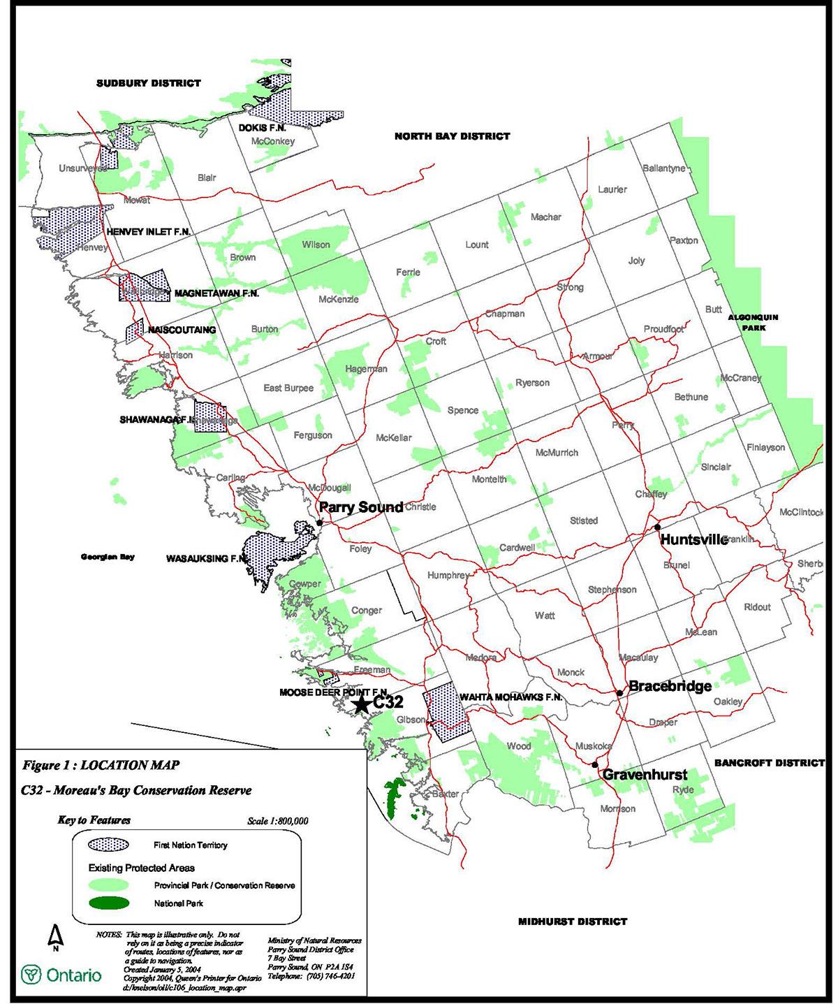
Moreau’s Bay Conservation Reserve is a 141 hectare area of Crown land in the north-west corner of Gibson Ward (with a small portion in Freeman Ward) in the Area Municipality of the Township of Georgian Bay in the District Municipality of Muskoka. It lies approximately 18 kilometres southwest of the hamlet of MacTier, and encompasses the Crown lands on Tate Lake and Iron City Bay, as well as a small stretch of shoreline of eastern Georgian Bay. There are a number of adjacent shoreline lots that are privately owned; these are not a part of the conservation reserve, and will remain privately owned.
The landscape of the site is characterized by bedrock plain, with wetlands lying between bedrock knobs. Portions of the shoreline provide excellent habitat for Atlantic Coastal Plain flora, and contain several rare plants and animals. The site contains excellent pike, muskellunge and bass spawning habitat.
The area, which is in ecological Site District 5E -7, has been identified as a Muskoka Heritage Area. Tate Lake and two other small areas that border, or are included in the conservation reserve, have been identified as having the potential of being provincially significant wetlands, through the use of satellite imagery and other available wetlands information.
Moreau’s Bay Conservation Reserve is one of 378 new protected areas approved through Ontario’s Living Legacy Land Use Strategy, aimed, in part, at completing Ontario’s system of parks and protected areas. It is part of the Great Lakes Heritage Coast, a signature site identified through Ontario’s Living Legacy Land Use Strategy. The Great Lakes Heritage Coast is designed to protect the coastal environment and provide for recreational and tourism opportunities associated with the natural environment.
During the "Lands for Life" planning process, the public was widely consulted and provided valuable input into what became Ontario’s Living Legacy Land Use Strategy. During consultation related to the formal Public Lands Act regulation of the boundaries of this conservation reserve (in 1999 and 2000) a number of minor boundary changes were made to reduce resource management conflicts, and to ensure the boundaries reflected areas requiring protection. Comments received during the consultation were generally supportive of the protection of this area. Stakeholders who provided comment during the earlier consultation for this site were subsequently consulted regarding the draft Statement of Conservation Interest and their comments were considered in the finalization of this document.
This Statement of Conservation Interest provides guidance for the management of the conservation reserve and provides the basis for the ongoing monitoring of activities. More detailed direction is not anticipated at this time. Should more complex resource management or conservation issues arise or significant facility development be considered, then a detailed Resource Management Plan will be prepared with full public consultation.
Moreau’s Bay Conservation Reserve is managed under the direction of the District Manager and the Parry Sound Area Supervisor of the Ministry of Natural Resources, Parry Sound District.
Approved by:
R. Griffiths
District Manager
Parry Sound District
Approved by:
Ron Running
Regional Director
Southern Region
Figure 1: Location of Moreau’s Bay Conservation Reserve

Enlarge Figure 1: Location of Moreau’s Bay Conservation Reserve
1.0 Introduction
Ontario’s Living Legacy, the result of an extensive planning process that began in early 1997, culminated in the approval in July 1999 of a Land Use Strategy that identifies the intended strategic direction for Crown land, including the completion of Ontario’s system of parks and protected areas. This process, which included extensive public consultation, resulted in the recommendation for regulation of 378 new protected areas, including Moreau’s Bay Conservation Reserve (C32). Ontario’s Living Legacy also identified Georgian Bay as part of the Great Lakes Heritage Coast. The Great Lakes Heritage Coast is designed to protect the coastal environment and provide for recreational and tourism opportunities associated with the natural environment.
Moreau’s Bay Conservation Reserve is a 141 hectare area of Crown land in the northwest corner of Gibson Ward in the Area Municipality of the Township of Georgian Bay in the District Municipality of Muskoka. It lies approximately 18 kilometres southwest of the hamlet of MacTier. The site is situated in the Go Home Bay area just north of Big Island, and encompasses the Crown lands on Tate Lake and Iron City Bay, as well as a small stretch of shoreline of eastern Georgian Bay. There are a number of adjacent shoreline lots that are privately owned; these are not a part of the conservation reserve, and will remain privately owned. The municipal road allowances, including the shoreline road allowance along Sand Run, Moreaus Bay and Iron City Bay are not a part of the conservation reserve.
Moreau’s Bay Conservation Reserve protects a network of wetlands surrounded by upland forest and rock barren communities. The area, which is in ecological Site District 5E -7, has been identified as a Muskoka Heritage Area. Tate Lake and two other small areas that border, or are included in the conservation reserve, (as well as a large area of wetlands to the east of the site) have been identified as having the potential of being provincially significant wetlands, through the use of satellite imagery and other available wetlands information.
Moreau’s Bay Conservation Reserve protects several examples of significant communities as well as habitat and populations of at least eight provincially rare species and numerous locally significant flora and fauna. The site also provides protection of ideal Atlantic Coastal Plain flora habitat.
Conservation reserves are established under the authority of the Public Lands Act, Ontario Regulation 805/94. Moreau’s Bay Conservation Reserve was established by Ontario Regulation 86/01 on April 6, 2001.
A Statement of Conservation Interest (SCI) is prepared under the direction of Procedural Guideline A – Resource Management Planning (PL. Procedure 3.03.05). The purpose of this SCI is to identify and describe the values of Moreau’s Bay Conservation Reserve. The SCI also outlines the activities that currently occur within the conservation reserve and provides guidelines for the management of current and future activities in the context of protecting the natural, recreational and cultural values.
1.1 Background information:
| Name | Moreau’s Bay Conservation Reserve (C32) |
|---|---|
| Site Region/District | 5E-7 |
| OMNR Administrative Region/District/Area | Southern Region/Parry Sound District/ Parry Sound Area |
| Total Area (ha.) | 141 hectares |
| Regulation Date | April 6, 2001 (O. Reg. 86/01) |
| First Nations | Robinson-Huron Treaty and Williams Treaty |
| OBM map sheets | 10 17 5800 49800, 5800 49850 |
| Topographic Map | Lake Joseph 31E/4 |
| UTM co-ordinates | 17T 58325 498300 (Centroid) |
1.2 Representation:
Earth science representation:
Bedrock
- Gneisses intruded by younger granitic plutons of the Go Home Domain, Algonquin Terrane in the Proterozoic Central Gneiss Belt of the Grenville Province
Surficial
- Bedrock plain with organic terrain between rock knobs. Surficial deposits are not considered significant
Life science representation:
Moreau’s Bay Conservation Reserve supports 9 different landform-vegetation types: 1 forest type; 1 rock barren type; and 7 wetland types; all within one biophysical unit. This site provides protection for an undisturbed peatland complex that provides habitat for more than 20 locally and provincially uncommon or rare species. The site also provides ideal Atlantic Coastal Plain flora habitat, with extensive emergent shoreline conditions during low water.
Cultural resources representation:
Neither detailed cultural research nor inventory has been carried out for this conservation reserve. Recent regional evaluation (OMNR, 2003) shows that this conservation reserve contains areas that have a high potential for cultural heritage sites.
Recreational opportunities:
A recreational inventory report was prepared for this site based on existing knowledge and data sources of MNR staff, recent site visits and also reflecting field observations made during the preparation of the life science report (Jalava, 2003). Adjacent Moreaus Bay and Iron City Bay offer boating opportunities, and the shoreline adjacent to this site has been used traditionally for mooring of watercraft. These adjacent waters offer angling opportunities. There is a potential of related picnicking and camping along the shoreline. Tate Lake is accessible by canoe or kayak. There are no roads or trails within the site, and no evidence that it is used by snowmobiles or all-terrain vehicles.
1.3 Survey work:
| Survey Level | Earth Science | Life Science | Cultural | Recreational | Other |
|---|---|---|---|---|---|
| Reconnaissance | Blackburn, 2003 | Cooper, 2001 | OMNR, 2003 | Brown, 2003 | None |
| Detailed | None | Reid/Bergsma, 1994 | None | None | None |
| Requirement | None | Monitor the status/presence of significant species and associations. | Research to be encouraged. | Monitor use impacts | None |
2.0 Values to be protected
This conservation reserve is located within Hills' (1959) ecological Site District 5E-7. Values include earth science, life science and recreational/aesthetic values, with an emphasis on the life sciences.
2.1 Earth science:
(Earth science information, unless otherwise noted, is taken from Blackburn, 2003)
Bedrock:
Moreau’s Bay Conservation Reserve lies within the Go Home Domain, Algonquin Terrane, in the Central Gneiss Belt of the Proterozoic Grenville Province. The Go Home Domain is divided into two gneiss associations, neither of which appears represented by this site. Younger intrusive granitic plutons (Go Home Complex) apparently underlie this site (Culshaw et al, 1991), but there may also be a presence of metasedimentary rocks. (Lumber & Vertolli, 2000).
The Grenville Province is the product of thrusting and imbrication of the crust to the northwest as it collided with a continental landmass to the southeast. The Grenville Orogeny, circa 1140 to 1070 million years ago, culminated more than 500 million years of crustal evolution. The eroded roots of the products of these events are displayed in the complexly metamorphosed and deformed rocks of the region (Easton, 1992b).
The Algonquin Terrane is one of four lithotectonic terranes of the Central Gneiss Belt. Within the Algonquin Terrane, the Go Home Domain is one of twelve structural domains. This geological environment is part of the modern organization of the complex products of the mid-Proterozoic Grenville orogenic events (Easton, 1992a & b). As such, their representation in Moreau’s Bay Conservation Reserve contributes to the conservation of the Grenville continental accretion theme outlined by Davidson (1981).
Within the Ontario Provincial Park system, the rocks of Moreau’s Bay Conservation Reserve have local significance in their representation of the Go Home Domain, Algonquin Terrane.
Surficial:
This conservation reserve lies in the Georgian Bay fringe physiographic region of southern Ontario, characterized by very shallow soil and bare rock knobs and ridges (Chapman and Putnam, 1984). Trusler (2004) observes that the sparse surficial deposits, dominated by bevelled sandy ice contact stratified drift, are likely primarily developed from a valley train esker, or possibly a bevelled kame. This view is based on observations in the area of the conservation reserve, as well as regional observations in the areas of Sandy Island and the Watcher Islands. The surficial geological features are not considered significant to the earth science conservation programme.
2.2 Life science:
(Life science information, unless otherwise noted, is taken from Cooper, 2001)
Representation:
Moreau’s Bay Conservation Reserve protects a network of wetlands surrounded by upland forest and rock barren communities. The south perimeter of the site includes an extensive area of sheltered shoreline with water generally less than two metres deep. Upland vegetation is predominantly oak-red maple forest with pockets of open rock barrens. Major depressions support a range of wetland community types, dominated by several leatherleaf (Chamaedaphne calyculata), sweet gale (Myrica gale ) and Virginia chain fern (Woodwardia virginica) peatlands.
According to current Ontario Ministry of Natural Resources (OMNR) digital biophysical mapping, Moreau’s Bay Conservation Reserve is located within one biophysical unit, "Weakly broken bare bedrock plain (organic)" (VIIa-7), thus representing part of the extensive tract of exposed bedrock along the Georgian Bay coastline (Noble 1983). Beaver activity has allowed for the creation of numerous wetland communities wi thin Tate Lake and other smaller areas along Sand Run and within Iron City Bay. As water levels change, the amount of open water in these wetland areas varies, exposing more or less substrate and accordingly, causing an increase or decrease in vegetation cover. These conditions and the extensive sheltered shoreline are ideal habitat for Atlantic Coastal Plain species.
The upland portions of Moreau’s Bay Conservation Reserve support two main vegetation community types, 'dry-fresh oak-red maple deciduous forest' and 'dry open acidic rock barren'. The forest community surrounds each of the wetland communities. It is dominated by red oak (Quercus rubra) and red maple (Acer rubrum ) with eastern white pine (Pinus strobus) as an associate. In some areas, ea stern white pine increases in dominance, resulting in small patches of white pine – oak forest. Common understorey vegetation includes lowbush blueberry (Vaccinium angustifolium), wild sarsaparilla (Aralia nudicaulis) and wild-lily-of-the-valley (Maianthemum canadense). Generally the soil is dry-fresh with an increase in moisture as the community grades from upland forest to meadow marsh shoreline. Where the soil moisture is higher, saplings and seedlings of sugar maple (Acer saccahrum ) are common, an indicator of richer soils.
Just east of Tate Lake, a minor depression within the oak – red maple forest community supports a small 'mountain holly organic thicket swamp'. Besides mountain holly (Nemopanthus mucronatus ), winterberry (Ilex verticillata) is also common, with reed-like three-way sedge (Dulichium arundinaceum ) and cinnamon fern (Osmunda cinnamomea) dominant species in the understorey.
Throughout the forest community several patches of open rock barrens are present, ranging in size from less than 0.5 hectare to 1.5 hectares. Generally, these communities are open, with bryophyte and lichen cover (Polytrichum spp, Cladina rangiferina) ranging between 15% and 40%. Of those that support tree growth, cover is less than 10% and dominant species are red oak and eastern white pine. Vegetation in these outcrop communities is predominantly limited to small localized patches, most commonly sheep sorrel (Rumex acetosella) with rough hair grass (Agrostis scabra), acuminate panic grass (Panicum acuminatum ) and crinkled hairgrass (Deschampsia flexuosa) as associates. Occasionally, localized shrub patches are found, with common juniper (Juniperus communis) and narrow-leaved meadow-sweet (Spiraea alba) frequently occurring as co-dominants. Several of these rock outcrop patches are adjacent to large wetland communities, providing ideal habitat for killdeer nesting, and two provincially rare reptile species, five-lined skink (Eumeces fasciatus ) and eastern massasauga rattlesnake (Sistrurus catenatus catenatus).
The upland forest and rock barren communities support a variety of characteristic Georgian Bay coast breeding birds. Representative species include veery (Catharus fuscescens ), vireo (Vireo spp ), flycatcher (Empidonax spp) and several warbler species (Dendroica spp). Several interior bird species are also found in this area including ovenbird (Seiurus aurocapillus ) and red-shouldered hawk (Buteo lineatus ).
Within Moreau’s Bay Conservation Reserve are three major depressions, supporting a variety of wetland communities. The largest of the three is located in the area known as Tate Lake. The drainage of Tate Lake occurs through an outlet to the south, which connects the lake to Iron City Bay and Sand Run, eventually leading out to open Georgian Bay. Open water within Tate Lake was minimal, making up less than 20% of the entire wetland community. The majority of the lake is covered with a complex of leatherleaf (Chamaedaphne calyculata) fen and bog types, varying in dominance and associated species. 'Leatherleaf – forb deciduous fen' type is the most common of these wetland types. This wetland type is found along virtually the entire perimeter of the lake with the exception of a few localized areas at the southern and eastern end that support small examples of other wetland types. As the community extends to the northern limits of the lake, an increase in sapling cover of eastern white pine and tamarack (Larix laricina ) grades into a 'white pine mineral coniferous swamp'. Leatherleaf continues to be an associate; however more patchy distribution allows for increased dominance in the herbaceous cover, with few-seeded sedge (Carex oligosperma ) and Virginia chain fern as the dominant species.
The western portion of the lake is made up of 'leatherleaf – sweet gale – graminoid shore fen' along the immediate shoreline, grading into 'leatherleaf – forb deciduous fen' approaching the centre of the lake. Tamarack forms a very open canopy in the 'leatherleaf – forb deciduous fen' and occurs in occasional patches throughout both communities. Leatherleaf is continuously dominant in both communities however patchy distribution allows some areas to be dominated exclusively by herbs; beaked sedge (Carex utriculata), common bogbean (Menyanthes trifoliata) and slender sedge (Carex lasiocarpa) are the most dominant. Both communities provide habitat for Atlantic Coastal Plain species such as Carolina yellow-eyed grass (Xyris difformis ). In addition breeding birds characteristic of this community include: common yellowthroat (Geothlypis trichas ), yellow warbler (Dendroica petechia ), swamp sparrow (Melospiza georgiana), alder flycatcher (Empidonax alnorum ), cedar waxwing (Bombycilla cedrorum ) and eastern kingbird (Tyrannus tyrannus ). Locally uncommon to rare bird species occurring in this community include Virginia rail (Rallus limicola), sedge wren (Cistothorus platensis) and sandhill crane (Grus canadensis ). The open water of the lake supports hooded merganser (Lophodytes cucullatus), ring-necked duck (Aythya collaris), A merican black duck (Anas rubripes ) and common loon (Gavia immer ). This extensive wetland supports a variety of amphibian and reptile species, including: large populations of green frog (Rana clamitans ) and bullfrog (R. catesbeiana), eastern ribbon snake (Thamnophis sauritus ) and midland painted turtle (Chrysemys picta marginata). This community also supports a variety of dragonfly and damselfly species.
The eastern portion of the lake is also dominated by 'leatherleaf – forb deciduous fen' however this area also supports a number of localized communities, including 'open graminoid shore fen' and 'sweet gale deciduous shrub fen type'. Both of these communities are open, with no tree cover. The 'open graminoid shore fen' is dominated by slender sedge with several occurrences of dragon’s mouth (Arethusa bulbosa), rose pogonia (Pogonia ophioglossoides ) and grass pink (Calopogon tuberosus ). The 'sweet gale deciduous shrub fen type' is dominated by sweet gale with slender sedge, twig-rush (Cladium mariscoides ) and common bogbean as associates. Combined, these two communities cover less than 15% of the entire Tate Lake wetland community.
Although the majority of Tate Lake is made up of fen communities, the southern portion of the lake is covered by a 'leatherleaf shrub bog' community. The dominant species is leatherleaf, with sweet gale an associate and localized patches of beaked sedge common in the herb layer.
The two other smaller wetlands within the site are located in inlets along Sand Run and in Iron City Bay. The dominant community type in these wetlands is 'sweet gale deciduous shrub fen type', with slender sedge the associate species and localized patches of common bogbean. In flooded areas, 'white pine mineral coniferous swamp' occurs, dominated by both eastern white pine and tamarack in the canopy layer and mountain holly, winterberry and sweet gale in the understorey. Habitat for swamp sparrow (Melospiza georgiana ) and northern leopard frogs (Rana pipiens ) is provided in this community type.
Condition:
The sheltered shoreline found along the south perimeter of the site and the western shoreline of the Tate Lake wetland complex provide ideal, undisturbed habitat for Atlantic Coastal Plain species.
Although there are a few cottage lots nearby, low water conditions prevent easy access to most of the site, ensuring minimal if any, human disturbance to the site. However, during periods of higher water, when Sand Run is navigable, Pittsburgh Channel and adjoining Iron City Bay are both subject to a considerably higher volume of boat traffic.
Despite potential for high use of the adjacent areas for cottage and associated recreational activities the site has an extremely low percentage of non-native species. Only one such species, the widespread sheep sorrel, was found and it was restricted to one community type, 'dry open acidic rock barren'. Upland forest and rock barren communities show no obvious disturbance; and wetland communities have, and continue to be affected by changes in water levels, resulting in flooding or the emergence of vegetation.
Diversity:
Moreau’s Bay Conservation Reserve supports 9 different landform-vegetation types: 1 forest type; 1 rock barren type; and 7 wetland types; all within one biophysical unit.
As documented during the 2001 field season, the site supports at least 138 different vascular plants, only one of which is not native to Ontario. In addition this site supports at least 39 species of breeding birds, 2 species of non-breeding birds, 5 species of reptiles (2 of which are provincially rare), 3 amphibian species and 11 species of Odonata (dragonflies and damselflies) 2 of which are provincially rare.
Ecological considerations:
Moreau’s Bay Conservation Reserve, protecting a network of wetlands surrounded by upland forest and rock barren communities, has previously been identified by the District Municipality of Muskoka as the Moreaus Bay Muskoka Heritage Area. (Reid & Bergsma, 1994) The conservation reserve provides protection for an undisturbed peatland complex, which provides habitat for more than 20 locally/provincially uncommon and/or rare species. The site also provides protection of ideal Atlantic Coastal Plain habitat, with extensive emergent shoreline conditions during low water.
Tate Lake and two other small areas that border, or are included in the conservation reserve, (as well as a large area of wetlands to the east of the site) have been identified as having the potential of being provincially significant wetlands, through the use of satellite imagery and other available wetlands information (Ducks Unlimited Canada and OMNR, 2003).
Special features:
Moreau’s Bay Conservation Reserve provides significant representation of the provincially and globally rare leatherleaf -forb shrub fen community, which is the dominant community of the Tate Lake wetland complex.
The conservation reserve protects populations of several provincially rare species, including: stiff yellow flax (Linum medium var medium ); elfin skimmer (Nanothemis bella); and sphagnum sprite (Nehelenia gracilis).
2.3 Cultural values:
No specific cultural studies or inventories have been undertaken within the conservation reserve, and no major cultural resource values have been evaluated or identified to date. Recent regional evaluation (OMNR, 2003) shows that this conservation reserve contains areas that have a high potential for cultural heritage sites.
2.4 Recreational/aesthetic values:
(Recreational information, unless otherwise noted, is taken from Brown, 2003)
This conservation reserve is accessible by boat only, as there are no roads or trails to it or within its boundaries. Adjacent Sand Run, Moreaus Bay and Iron City Bay offer good fish habitat, and are used for angling. There is also a tradition of mooring along this stretch of shoreline, with access to the shore for tying up, and for picnicking and possibly camping. Such activities are usually confined to the municipally owned shoreline road allowance, and have little impact on the conservation reserve itself. The amount of boat traffic in the immediate vicinity is determined by Georgian Bay water levels. Access is somewhat limited during periods of low water. Tate Lake, within the boundaries of the site, is accessible by canoe or kayak, and offers potential for angling. However, the nature of the shoreline on this lake (low and wet) precludes access to land for picnicking or camping.
The distance of this conservation reserve from urban areas has resulted in a relatively pristine night sky, which enhances the sense of remoteness and wilderness of this site. Pristine night skies are considered a significant value, given the increasingly limited areas of southern and central Ontario which are not heavily affected by light pollution.
3.0 Management guidelines
3.1 Land tenure:
Background:
Moreau’s Bay Conservation Reserve comprises 141 hectares of Crown land in the northwest corner of Gibson Ward (with a small portion in Freeman Ward) in the Area Municipality of the Township of Georgian Bay in the District Municipality of Muskoka. It encompasses the Crown lands on Tate Lake and Iron City Bay, as well as a small stretch of shoreline of eastern Georgian Bay. There are a number of adjacent shoreline lots that are privately owned; these are not a part of the conservation reserve, and will remain privately owned. The municipal road allowances, including the shoreline road allowance along Sand Run, Moreaus Bay and Iron City Bay are not part of the conservation reserve. Neither is the bed of adjacent Georgian Bay a part of this site.
The conservation reserve is located within OMNR Bear Management Area, PS-46-17. There are also two OMNR registered traplines (PS 182 and PS 184) that have portions of their harvest areas within the conservation reserve. The conservation reserve lies within two commercial Bait Fish Blocks (PS0183 & PS0213).
There are no authorized recreation camps or recreation trails within the conservation reserve.
Guideline:
The sale of Crown lands within the conservation reserve generally is not permitted. Exceptions will only be considered under unusual circumstances, such as where an adjacent privately owned parcel has inadequate area for the installation of a septic system.
There are no plans by the MNR to acquire private lands to add to the conservation reserve.
The commercial bear hunting service associated with the current Bear Management Area is allowed to continue. Fur harvest is permitted to continue in the registered trapline areas. The Bait Fish Blocks are permitted to continue.
New recreation camps are not permitted.
3.2 Development:
Background:
There are no Crown owned buildings or other facilities within the conservation reserve.
There are no roads or recreation trails within the site. Access to the area is by boat.
Guideline:
This site contributes to the Great Lakes Heritage Coast initiative by providing important protection to the coastal environment. As well, the site and areas immediately adjacent may provide opportunities for improved boating facilities such as mooring, day use and camping.
Implementation of the Great Lakes Heritage Coast may provide for the future consideration of upgrading recreational and interpretive facilities including access, trails, camp sites, as well as boating and mooring facilities. New facilities will only be considered where either long-term funding is available, or a long-term partnership will provide for long-term management of the facilities. All facility improvements will ensure the protection of natural values of this site, will meet MNR's Environmental Assessment Act requirements, including requirements for public consultation, and will comply with Procedural Guideline B – Land Uses - Test of Compatibility (see Appendix 1). Major new facility development will involve public consultation.
New roads for resource extraction and/or private use will not be permitted. There is no intention to develop roads outside of the conservation reserve to improve access to this site.
New recreational trails may be considered on a case by case basis provided that they meet Procedural Guideline B – Land Uses – Test of Compatibility (see Appendix 1) and the MNR's Environmental Assessment Act requirements. Public consultation will generally be required during the consideration of changes to existing trails, and will always be required for new trails. New recreational trails will not be permitted in or within 120 metres of the wetlands that have been assessed as having high potential to be provincially significant wetlands unless it has been demonstrated that there will be no negative impacts on the natural features or the ecological functions of the wetland.
New recreational trails for motorized vehicles will not be permitted, unless the following have been demonstrated:
- there is a community need for the trail, as well as community support
- there are no alternative suitable locations outside the conservation reserve
- the trail location would be acceptable and suitable for four-season use
- the trail would meet the requirements applicable to all trails, as ident ified in the preceding paragraph
The use of this site will be monitored to ensure that conservation reserve values are not being adversely impacted.
Unauthorized works within the conservation reserve will be handled in accordance with the Public Lands Act, and any required removal of improvements will be at the expense of those responsible.
No mineral exploration is permitted within this conservation reserve. This policy decision is based on a commitment made by the Ministry of Natural Resources and the Ministry of Northern Development and Mines in March 2002. This policy direction replaces that identified in the 1999 Ontario’s Living Legacy Land Use Strategy, which stated that controlled mineral exploration would be permitted in new conservation reserves which were identified as having provincially significant mineral potential.
Any new development must meet MNR's commitments to protect cultural heritage values (see Section 3.7).
While there is no intent at present to provide or permit any new development in this conservation reserve that would require lighting, should this be considered at some point in the future the MNR will not allow unnecessary, undirected light pollution. This commitment recognizes the wilderness values provided by a pristine night sky.
3.3 Recreational activities:
Background:
The nature of this site, and the lack of access, limit the potential of this site for recreational use.
Sport fishing occurs adjacent to and within the site’s boundaries. The adjacent navigable waters have the potential for recreational boating, and mooring in the sheltered waters of Moreaus Bay may occur, particularly when higher Georgian Bay water levels allow easier access into the area. Related use of the shoreline for shore access, picnicking and camping may also occur.
It is likely (though not documented) that some hunting occurs within the site.
There is little evidence of the use of the conservation reserve by hikers, birdwatchers, canoeists, mountain bikers, skiers, or snowshoers, and little opportunity for these activities because of the nature of the site, and the lack of access.
Guideline:
Sport fishing is permitted to continue within and adjacent to the conservation reserve. Recreational use such as hiking, wildlife viewing, snowshoeing, and cross-country skiing, while currently very limited in extent and therefore not managed, will be allowed to occur in the conservation reserve.
Hunting is also a permitted activity within the conservation reserve. Off-trail use of snowmobiles and all-terrain vehicles is only permitted for the direct retrieval of game. Such use will be monitored to ensure that the conservation reserve values are not being adversely impacted.
Mooring, camping and picnicking will be allowed to continue on conservation reserve lands. These uses will be monitored. Where overuse develops, or where these uses threaten the values for which these sites were established, specific use areas may be limited, or closed.
As discussed in Section 3.2 Development, new recreational trails may be considered on a case by case basis provided that they meet Procedural Guideline B – Land Uses – Test of Compatibility (see Appendix 1) and the MNR's Environmental Assessment Act requirements. Public consultation will generally be required during the consideration of changes to existing trails, and will always be required for new trails. New recreational trails will not be permitted in or within 120 metres of the wetlands that have been assessed as having high potential to be provincially significant wetlands unless it has been demonstrated that there will be no negative impacts on the natural features or the ecological functions of the wetland. Any new trails must meet MNR's commitments to protect cultural heritage values (see Section 3.7).
New recreational trails for motorized vehicles will not be permitted, unless the following have been demonstrated:
- there is a community need for the trail, as well as community support
- there are no alternative suitable locations outside the conservation reserve
- the trail location would be acceptable and suitable for four-season use
- the trail would meet the requirements applicable to all trails, as identified in the preceding paragraph
New recreational activities will be considered on a case by case basis provided they are consistent with maintaining the values of the conservation reserve and comply with Procedural Guideline B – Land Uses – Test of Compatibility (Appendix 1). Emphasis will be placed on activities that have a low impact on the environment of the conservation reserve.
Monitoring of existing and permitted activities will be undertaken as required to ensure that the conservation reserve values are not being adversely impacted.
3.4 Commercial activities:
Background:
There has been no recent commercial forest harvesting or mining activity within the conservation reserve.
Commercial fur harvesting is authorized through registered traplines. The guiding of non-resident bear hunters is authorized through the Bear Management Area, and bait fish harvesting is authorized through Bait Fish Block licences that extend into the conservation reserve. These activities were discussed in Section 3.1 Tenure – Background.
Guideline:
Fur harvesting, bear hunting services and bait fish harvesting operations will be allowed to continue within the conservation reserve. New trapline cabins are not permitted within conservation reserves.
Mineral exploration is not allowed in this conservation reserve, as discussed in Section 3.2.
Conservation reserve regulations do not permit mining, commercial forest harvesting, hydroelectric power development, the extraction of aggregate and peat or other industrial uses (Public Lands Act, Ontario Regulation 805/94). Other new commercial activities must meet the requirements of Procedural Guideline B – Land Uses – Test of Compatibility (see Appendix 1).
While commercial timber harvesting is not allowed within conservation reserves, there are limited situations in which adjacent land owners can harvest firewood for use on their adjacent property. Specifically, property owners and recreation camp permittees who have no road access to their properties can apply for permits to cut limited amounts of firewood in the conservation reserve for their own use. This situation would apply only to water access cottages or recreation camps that are immediately adjacent to conservation reserve boundaries, and that do not have road access.
3.5 Aboriginal interests:
Background:
This site is known to be of interest to many First Nation communities. There are 2 treaties associated with the area: the Robinson – Huron Treaty of 1850 and the Williams Treaty. A Supreme Court decision in 1994 (Howard) validated that the Williams Treaty surrendered hunting, fishing and trapping rights of those First Nations affiliated with that treaty.
Guideline:
The regulation and management of this conservation reserve will not impede the exercise of existing aboriginal or treaty rights. These rights include hunting, fishing, fur harvesting, gathering of plants for a variety of purposes, and the use of ceremonial sites. It is recognized that the manner in which these rights are carried out is not limited to the manner in which they were carried out in the past, but has evolved over time with changes in technology.
While there are no existing First Nation land claims that extend to this site, it is recognized that at some point in the future there is a possibility of a land claim in this area. If such a land claim is determined to be valid, the conservation reserve designation is not irreversible and does not preclude consideration of these lands in the settlement of a claim. If deregulation of part or all of a conservation reserve occurs as part of the settlement of a claim, this will be carried out at no cost to First Nations.
3.6 Natural Resource Stewardship:
Background:
Vegetation management for specific purposes is not known to have occurred in the past. Wildlife and fisheries management, particularly sport fishing, hunting and fur harvesting, have been occurring according to the prevailing policies and legislation.
It is noted that the wetlands of this site have been identified as having the potential of being provincially significant wetlands, through the use of satellite imagery and other available wetland information. Management and protection emphasis will be on ensuring that these wetlands and other natural values of the conservation reserve are not negatively affected by current and future activities. Therefore, applications for new specific uses will be carefully studied and reviewed. Necessary studies may be undertaken by proponents, the Ministry, and/or partner organizations.
Guideline – vegetation:
The intent of this site is to allow the existing vegetation communities to evolve naturally. The Ministry will continue to monitor for the status/presence of significant species and associations.
The OMNR recognizes fire as an essential process fundamental to the ecological integrity of this conservation reserve. In accordance with existing conservation reserve policy and the Forest Management Strategy for Ontario, forest fire protection will endeavour to use "light on the land" techniques, which do not unduly disturb the landscape, in this conservation reserve. Examples of light on the land techniques may include limiting the use of heavy equipment, and limiting the number of trees felled during fire response efforts. Input from the local MNR Area Supervisor would be solicited if a forest fire threatens the area. Opportunities for prescribed burning to achieve resource management objectives may be considered. Plans for any prescribed burning will be developed in accordance with the OMNR Prescribed Burn Planning Manual.
Programs may be developed to control forest insects and diseases in the conservation reserve where these threaten significant values in or adjacent to the site. Where insects or disease threaten significant values, in or adjacent to the site, and MNR determines that control is warranted, control within the conservation reserve will be directed by the MNR as narrowly as possible to the specific insect or disease. Biological control will be used wherever possible. In all cases, regard shall be had for Procedural Guideline B – Land Uses – Test of Compatibility (see Appendix 1).
Guideline – wildlife and fisheries:
The relevant Ontario hunting and fishing regulations will guide hunting and fishing within Moreau’s Bay Conservation Reserve. Fur harvesting and bait fishing will be managed through the maintenance of the current licensing system.
The Ministry will monitor the impacts of use of this site on the natural values of the conservation reserve.
3.7 Cultural Resource Stewardship:
Background:
Recent regional evaluation (OMNR, 2003) shows that this conservation reserve contains areas that have a high potential for cultural heritage sites. However, no specific studies or inventories have been undertaken within the conservation reserve, and no specific significant cultural resource values have been evaluated or identified to date.
Guideline:
Should the MNR consider either carrying out or permitting new structural development, significant clearing of vegetation or altering of land within this conservation reserve, the MNR will adhere to the cultural heritage resource screening process as is identified in its Memorandum of Understanding (MOU) with the Ministry of Culture. While the purpose of this MOU is to provide a process to identify and protect cultural heritage resources when the MNR is reviewing work permits or disposing of Crown rights under the authority of the Public Lands Act, the considerations and criteria would also enable the MNR to identify high potential cultural heritage areas for other purposes within conservation reserves. If the screening process indicates that the site of a proposed activity is within an area of high cultural heritage potential, the MNR will consult with the Ministry of Culture to determine the appropriate cultural heritage assessment requirements and will undertake a preliminary archaeological assessment if appropriate.
Interested partners will be encouraged to undertake inventories, studies, and research to document the histories of First Nations, settlement, resource harvest/management and recreation in the area. The MNR will discuss the appropriateness of any proposed archaeological assessment with local First Nations and the Ministry of Culture.
3.8 Client services:
Background:
Access to the conservation reserve has generally been confined to traditional uses for the current commercial and recreational activities. There are no Crown facilities or services developed on or adjacent to the conservation reserve. The information fact sheet for this conservation reserve is currently available to the public through the Parry Sound District Office, or via the Internet at www.ontarioslivinglegacy.com (link no longer active) .
Guideline:
The focus will remain on low key information and self-interpretation of conservation reserve values and features. Consideration will be given to the preparation of an information brochure (with map) to highlight the features for which the area was identified and appropriate uses to ensure the protection of those features.
Consideration will be given to the strategic location of identity signs on the shoreline where there is evidence of mooring, picnicking or camping.
3.9 Research:
Background:
Research to date has included the preparation of a number of check sheets to document life science values, earth science values, and recreation potential and values, and the recent identification of wetlands with potential of being provincially significant. The area was also studied under the Natural Heritage Evaluation of Muskoka, Muskoka Heritage Areas Program, which led to its identification as the Moreaus Bay Muskoka Heritage Area.
Guideline :
Research will be encouraged on the wetlands of this site, and their significant species and habitats. This will include evaluation of the wetlands using the Ontario Wetland Evaluation System Northern Manual (1993), to confirm their potential as provincially significant wetlands.
Research focusing on the assessment of use and activity impacts on sensitive species and habitats will be encouraged.
Research focusing on the prehistoric and historic use of the conservation reserve and its vicinity will be encouraged.
All research will be carried out in a non-destructive manner. Research proposals must follow Procedural Guideline C – Research Activities in Conservation Reserves (Appendix 3).
3.10 Marketing:
Background:
There has been no marketing of this conservation reserve to date. Promotion and information about this site has been primarily through the Ontario’s Living Legacy planning process and recent MNR Parry Sound District public consultation regarding the boundaries of this site.
Guideline:
Marketing activities of this conservation reserve will be kept to a minimum. This site may be the subject of marketing efforts for the Great Lakes Heritage Coast.
4.0 Implementation
Administrative responsibility for this conservation reserve belongs to the Parry Sound Area Office of the Parry Sound District of the Ministry of Natural Resources. The Area Office will continue to have the custodial care of Moreau’s Bay Conservation Reserve. Emphasis will be placed on awareness information highlighting reserve values, and monitoring and managing the current approved uses.
Priorities will include:
- Ensure compliance to prescribed management direction of the approved Statement of Conservation Interest
- Encourage research and studies focusing on the prehistoric and historic use of the conservation reserve and its vicinity
- Monitor and evaluate existing and allowed recreational and commercial use levels and impacts as required to ensure that conservation reserve values are not being adversely impacted
- Encourage further inventory and research of the significant life science resources of the conservation reserve
- Encourage research about significant flora and fauna species and communities, and potential impact on these by various recreation activities
- Encourage evaluation of the wetlands using the Ontario Wetland Evaluation System Northern Manual (1993), to confirm its potential as a provincially significant wetland
- Support cooperative ongoing education of resource users with respect to resource and land stewardship values, in order to maintain the ecological integrity of the site and to provide long term recreational opportunities
- Implement future initiatives associated with the Great Lakes Heritage Coastline; and
- Provide client services (e.g. brochure or fact sheet) at nearby MNR offices
5.0 Review and revision of the Statement of Conservation Interest
This Statement of Conservation Interest will be amended through a standard process of minor and major amendments. Minor amendments will be processed in a relatively informal manner and will require the approval of the Area Supervisor. These amendments will deal with uses and activities that do not affect any of the policies in this SCI (e.g. new uses and/or activities that are consistent with existing permitted uses).
Uses and/or activities that were not anticipated in the approved SCI and which may have an impact on the values of the conservation reserve will require a major amendment. This will include an opportunity for public comment and input, and will require the approval of the District Manager and Regional Director.
6.0 References
Blackburn, C. E. 2003. C32 Moreau’s Bay Conservation Reserve. Earth Science Report, OMNR Peterborough.
Brown, B. 2003 Recreation Resource Inventory Report. Moreau’s Bay Conservation Reserve. OMNR Parry Sound.
Chapman, L. J. and Putman, D. F. 1984. Ontario Geological Survey, Special Volume 2, The Physiography of Southern Ontario, Third Edition. OMNR.
Cooper, W. L. 2001. Natural Heritage Area – Life Science Checksheet Moreau’s Bay Conservation Reserve (C32). OMNR, Parry Sound.
Culshaw, N. G., Check, G., Corrigan, D., Drage, D., Gower, R., Haggart, M. J., Ketchum, J., Wallace, P., Wodocka, N. 1991, Unpublished. Bedrock Geology, Lake Joseph, NTS 31/E4 Canada/Ontario Mineral Development Agreement, Scale 1:50,000.
Davidson, R. J. 1981. A framework for the conservation of Ontario’s earth science features. Ontario Ministry of Natural Resources, Toronto.
Ducks Unlimited Canada and OMNR. 2003. Enhanced Wetland Mapping and Evaluation for Ontario’s Forested Shield. In Preparation for the District of Muskoka.
Easton, R. M. 1992a. The Grenville Province and the Proterozoic history of central and southern Ontario; in Geology of Ontario, Ontario Geological Survey , Special Volume. 4, Part 2.
1992b. Tectonic evolution of Ontario. Part 3: Mesoproterozoic evolution of the southeast margin of Laurentia; in Geology of Ontario, Ontario Geological Survey, Special Volume 4, Part 2.
Hills, G. A. 1959. A Ready Reference to the Description of the Land of Ontario and its Productivity. Ont. Dept. of Lands and Forests, Division of Research, Maple, Ontario.
Lumbers, S. B. and Vertolli, V. M. 2000. Precambrian geology, Lake Joseph Area; Ontario geological Survey, Preliminary Map P3412, Scale 1:50,000.
Noble, T. W 1983. Biophysiographic Analysis, Site Region 5E, Algonquin Region, Ministry of Natural Resources. Algonquin Region, Huntsville.
Ontario Ministry of Natural Resources. 1999. Ontario’s Living Legacy: Land Use Strategy. Queen’s Printer for Ontario.
2003. Cultural Heritage Registered Site Reserves and Areas of High Potential, Parry Sound District, Scale 1:150000.
Reid, R. and B. Bergsma. 1994. Natural Heritage Evaluation of Muskoka. Muskoka Heritage Areas Program. Bracebridge, Ontario.
Trusler, J., 2004. March 26, 2004 E-mail to Dorothy Shaver, MNR, re Moreau’s Bay Conservation Reserve Statement of Conservation Interest.
Appendices
Appendix 1 procedural guideline B – Land Uses – Test of Compatibility (PL procedure 3.03.05)
The conservation reserve policy provides broad direction with regard to the permitted uses. The policy provides only an indication of the variety of uses that will be considered acceptable in conservation reserves. The only caution is that "any new uses, and commercial activities associated with them, will be considered on a case by case basis, and, they must pass a test of compatibility to be acceptable." What does a 'test of compatibility' mean?
An examination of this must start from the premise of why an area is set aside – specifically, its representative natural heritage values. Criteria are then identified to guide compatibility considerations. These criteria apply to the long-term acceptability of both existing uses and new uses.
-
Conformity to SCI/RMP: SCI describe values for which an area has been set aside and the range of appropriate uses that will be permitted in the area. SCI may also speak to the acceptability of other 'new' uses currently not occurring in the area.
The first 'test' is: "do proposed new land uses and/or commercial activities conform to the direction of the SCI/RMP for the conservation reserve? Would the new use(s) depart from the spirit of appropriate indicator land uses in the SCI/RMP?"
- Impact Assessment: If the proposed use(s) pass test 1 it is important to determine their impact on the area before they are approved. This should include the following:
- Impact on natural heritage values: "will the new use(s) impact any natural values in the area? If so how and to what degree? Is it tolerable?"
- Impact on cultural values: "will the new use(s) impact an historical or archaeological values in the area?"
- Impact on research activities: "will the new use(s) affect research activities in the area?"
- Impact on current uses: "will the new use(s) have any negative impact on the array of current uses?"
- Impact on area administration: "will the new use(s) increase administrative costs and/or complexity?" (For example, the cost of area monitoring, security and enforcement).
- Impact on accommodating the use outside the conservation reserve: "Could the use(s) be accommodated as well or better outside the conservation reserve?"
- Impact on socio-economics of the area: "will the new use(s) affect the community(ies) surrounding the area in a positive or negative way?" (For example, will the new use make an area less remote thereby affecting a local tourism industry that is dependent on the area’s remoteness for its appeal?"
- Impact on area accessibility: "does the new use(s) give someone exclusive rights to the area or a portion of the area to the exclusion of other existing uses?"
The following table (Appendix 2) provides a guide of indicator uses for the consideration of uses that may be permitted within conservation reserves. For any specific conservation reserve that test of compatibility should be applied to determine which specific uses are acceptable.
Appendix 2 Indicator uses for Conservation Reserves:
Generic and specific
Recreation
| Activities | Generic Policy Permitted? Existing |
Generic Policy Permitted? New |
Specific Application in Moreau’s Bay Conservation Reserve C32 |
|---|---|---|---|
| Sport fishing | Yes | Yes | Yes |
| Sport hunting | Yes | Yes | Yes |
| Food gathering | Yes | Yes | YesA |
| Facility infrastructure | Maybe | Maybe | Maybe |
| Off-trail snowmobiling | No1 | No1 | No1 |
| Off-trail all-terrain vehicle use | No1 | No1 | No1 |
| Rock climbing/caving | Maybe | Maybe | N/A |
| Canoeing/kayaking | Yes | Yes | Yes |
| Motorized boating | Yes | Yes | Yes |
| Picnicking | Yes | Yes | Yes |
| Camping | Yes | Yes | Yes |
| Trails: Hiking | Yes | Maybe | MaybeB |
| Trails: X country skiing | Yes | Maybe | MaybeB |
| Trails: Cycling | Yes | Maybe | MaybeB |
| Trails: Horse riding | Yes | Maybe | MaybeB |
| Trails: Snowmobiling | Yes | Maybe | MaybeB |
| Trails: All-Terrain Vehicles | Yes | Maybe | MaybeB |
Science, education & heritage appreciation
| Activities | Generic Policy Permitted? Existing |
Generic Policy Permitted? New |
Specific Application in Moreau’s Bay Conservation Reserve C32 |
|---|---|---|---|
| Research | Yes | Yes | Yes |
| General walking | Yes | Yes | Yes |
| Photography & Painting | Yes | Yes | Yes |
| Wildlife viewing | Yes | Yes | Yes |
| Outdoor Education/Interpretation | Yes | Yes | Yes |
| Collecting | No | Maybe2 | Maybe2 |
Commercial activities
| Activities | Generic Policy Permitted? Existing |
Generic Policy Permitted? New |
Specific Application in Moreau’s Bay Conservation Reserve C32 |
|---|---|---|---|
| Food harvesting | Maybe | Maybe | No |
| Fishing | Maybe | Maybe | No |
| Baitfish harvesting | Yes2 | Maybe | Yes |
| Fur Harvesting | Yes2 | Maybe | Yes |
| Trap cabins | Yes | No | MaybeC |
| Resort – outpost camp | Yes2 | No | NoC |
| Outfitting – bear management | Yes2 | No | Yes |
| Wild rice harvesting | Yes | Maybe | Maybe |
Resource management
| Activities | Generic Policy Permitted? Existing |
Generic Policy Permitted? New |
Specific Application in Moreau’s Bay Conservation Reserve C32 |
|---|---|---|---|
| Inventory monitoring | Yes | Yes | Yes |
| Featured species management | Maybe | Maybe | Maybe |
| Natural systems management | Maybe | Maybe | Maybe |
| Insect and disease control | Maybe | Maybe | Maybe |
Industrial activities
| Activities | Generic Policy Permitted? Existing |
Generic Policy Permitted? New |
Specific Application in Moreau’s Bay Conservation Reserve C32 |
|---|---|---|---|
| Timber harvesting | No | No | No |
| Mineral exploration | No | No | No |
| Mining | No | No | No |
| Hydro generation | No | No | No |
| Energy transmission corridors | Yes | No4 | No4 |
| Communications corridors | Yes | No4 | No4 |
| Public Transportation corridors | Yes | No4 | No4 |
| Resource access roads | Maybe | No | No |
| Private access roads | Maybe | No | No |
Other activities
| Activities | Generic Policy Permitted? Existing |
Generic Policy Permitted? New |
Specific Application in Moreau’s Bay Conservation Reserve C32 |
|---|---|---|---|
| Land Disposition | Maybe6 | No6 | No6 |
| Recreation Camps | YesC | No3 | No |
Notes:
On generic policy application in conservation reserves:
1For direct retrieval of game only.
2Only as a part of an approved research project.
3Transfer requests will be considered in the context of the Statement of Conservation Interest or Resource Management Plan for each conservation reserve.
4Existing use is permitted to continue. New transportation corridors, communications lines, and transmission lines are discouraged in conservation reserves except under unusual circumstances where there are no other viable alternatives.
5New private roads, including additions to existing roads, will not be permitted except where there are existing commitments.
6Sale of Crown lands in conservation reserves is not permitted, except for certain minor dispositions (e.g. sale of small parcel of land where adjacent private lot is too small to enable installation of a septic system, or to facilitate legal title to lands where there has been a long-standing encroachment of a dwelling on Crown land) where they do not detrimentally affect the values an area is intended to protect.
On specific policy application in Moreau’s Bay Conservation Reserve:
AFood gathering is permitted for personal consumption only and must be conducted in a sustainable manner, and such that it does not harm the values of the conservation reserve.
BB. Existing authorized recreational trails are permitted to continue in conservation reserves as long as there are no significant environmental impacts and they do not impair the natural features and values for which the area is identified. Additional high impact recreational trails are discouraged, but new trails may be considered on a case by case basis, provided they comply with Procedural Guideline B – Land Uses – Test of Compatibility (Appendix 1) and the MNR's Environmental Assessment Act requirements.
CExisting authorized uses can continue. New cabins, outpost camps and private recreation camps are not permitted.
DExisting authorized recreation camps are eligible for enhanced tenure, but not for the purchase of lands. A decision to grant enhanced tenure or to transfer recreation camps will be addressed through a screening process.
Appendix 3 Procedural Guideline C
Research activities in Conservation Reserves (PL procedure 3.03.05)
Purpose
To encourage contributions to the goal of conservation reserves by:
- Providing direction for research activities associated with conservation reserves; and
- Establishing a process for the review and approval of proposals by researchers, which could have an impact on the values protected by the conservation reserve
Definition
Research means any investigation or study of the natural, cultural, economic, management or other features or characteristics of conservation reserves.
Guidelines
Research will be encouraged to provide a better understanding of the natural values protected by a conservation reserve and to advance their protection, planning and management. The Statement of Conservation Interest will define, for each conservation reserve, the key research issues, set out the parameters within which research may occur and identify research needs.
Applications and approvals
Researchers must apply in writing to the Area Supervisor for permission to conduct research. The request letter must contain a statement explaining why the proposed research should be undertaken in the particular conservation reserve in preference to another location.
Proposals will be reviewed and approved by the Area Supervisor, guided by the SCI prepared for each reserve (see Guideline A – Resource Management Planning) and using Guideline B – Land Uses – Test of Compatibility. Permission must be granted in writing, including any conditions to be met in conducting the research, prior to the undertaking of any research project.
Term and conditions
Permission to conduct research under this policy will be valid for a period of 12 consecutive months from the date of issue. Permission to continue a research project for an additional period of 12 months or less may be granted upon submission of a written request and a progress report. The Ministry may require the posting of collateral to assure that the terms and conditions of granting permission are met.
The Area Supervisor may suspend or revoke permission at any time for failure on the part of the researcher to meet:
- The intent of this policy
- The requirements under the Public Lands Act, Ontario Regulation 805/94, including all amendments, where applicable
- The requirements under any other Act or regulations of Ontario or Canada, including those governing the taking, handling, storing, confining, fur harvesting, excavating and marketing any specimen, artefact, information or action (for example, scientific collector’s permit)
- The conditions and agreements specified in granting permission
Final report
The researcher will submit copies of reports, publications and theses following the results of the project to the Area Supervisor.