Mount Moriah Conservation Reserve Management Statement
This document provides policy direction for the protection, development and management of the Mount Moriah Conservation Reserve and its resources.
Statement of Conservation Interest
March 9, 2004
Approval statement
We are pleased to approve this Statement of Conservation Interest (SCI) for the Mount Moriah Conservation Reserve (C18). It is one of 378 new protected areas approved through Ontario’s Living Legacy, a land use strategy aimed, in part, at completing Ontario’s system of parks and protected areas.
The Mount Moriah Conservation Reserve consists of a 2319 hectare area of Crown land, located in Hastings County about 30 kilometers north of the Village of Tweed. The site is in the geographic township of Grimsthorpe.
This conservation reserve, located in Ecodistrict 5E-11, is the most dramatic landscape feature in southcentral Hastings County, rising hundreds of feet above the surrounding land, which is predominantly undeveloped. Where forests exist, they are often scrubby Red Oak and Aspen. There are also vast areas of open rock barrens, extensive granite barrens, steep bedrock slopes, small cliffs and outcrops. This diverse topography has trapped water in many shallow ponds, poor fens and flooded areas. Mount Moriah was recommended for designation as a provincially significant Area of Natural and Scientific Interest (ANSI) by Brunton in 1990 for its provincially significant representation of a wild area of undisturbed dry-site upland forest and barrens.
The site has a history of recreational use and resource management prior to being recommended as a conservation reserve through Ontario’s Living Legacy. It has been used for remote recreational activities, mining exploration and forest management, and has been managed under policies and legislation applicable to Crown land.
This Statement of Conservation Interest provides guidance for the management of the Mount Moriah Conservation Reserve and provides the basis for the ongoing monitoring of activities.
Administrative responsibility for the Mount Moriah Conservation Reserve lies with the Ministry of Natural Resources through the Mazinaw Area Team in Bancroft District.
Approved by:
Monique Rolf von den Baumen-Ciark
District Manager
Bancroft District
Approved by:
Ron Running
Regional Director
Southern Region
1.0 Introduction
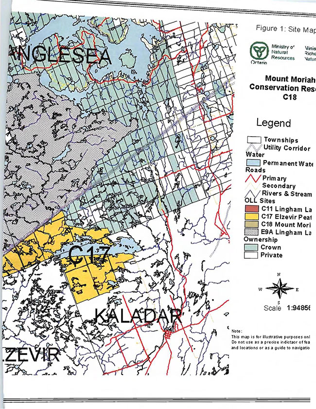
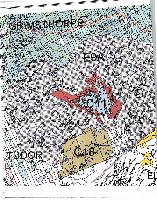
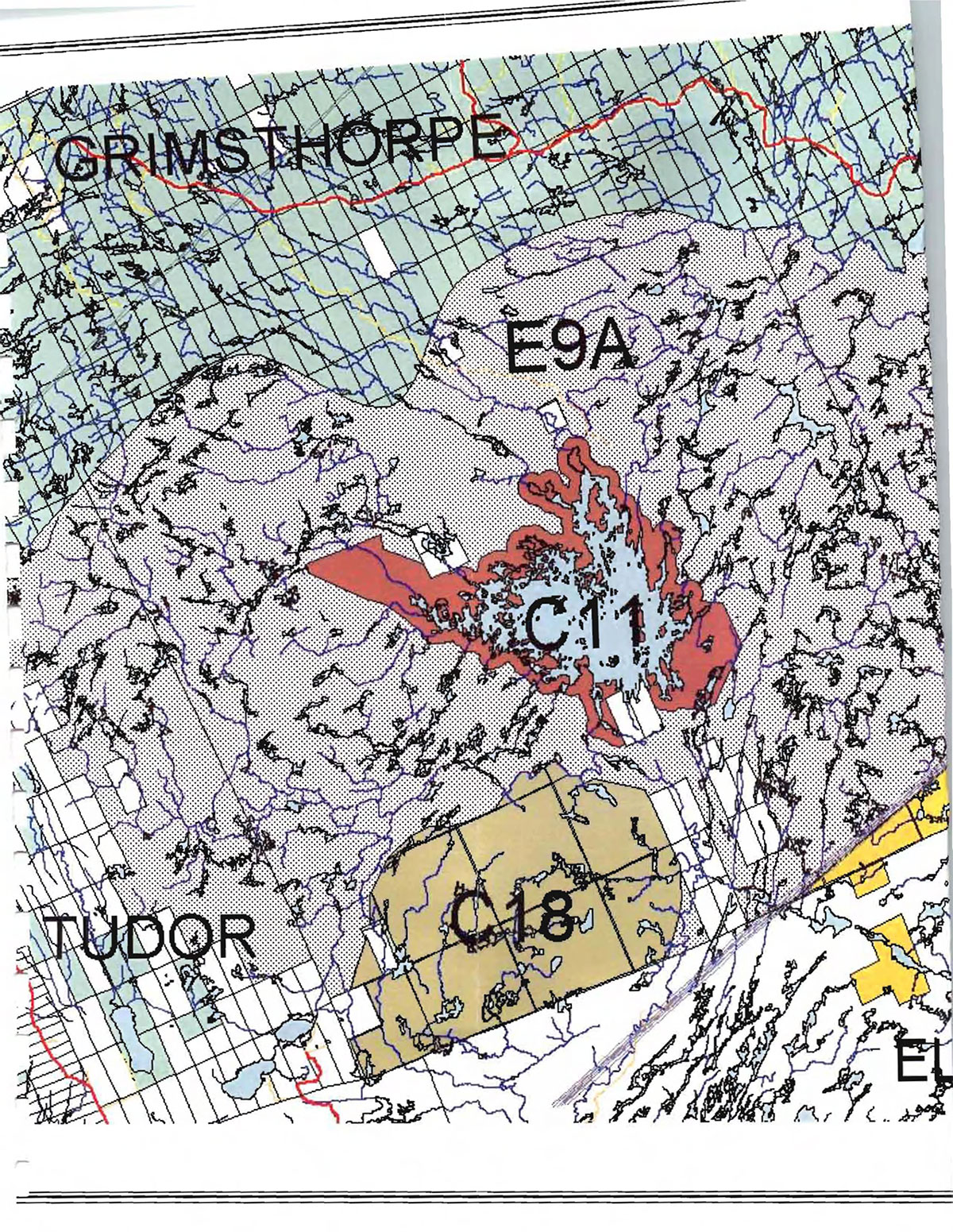
The Mount Moriah Conservation Reserve (C18) is a 2319 hectare area of Crown land, located in Hastings County, in the geographic township of Grimsthorpe about 30 kilometers north of the Village of Tweed. This conservation reserve, located in Ecodistrict 5E-11 (previously known as Site District 5E-11), is the most dramatic landscape feature in southcentral Hastings County, rising hundreds of feet above the surrounding land. It lies between the west and east arms of the Black River and is southwest of Lingham Lake Conservation Reserve (see Figure 1: Site Map). The conservation reserve includes nearly all of Mount Moriah. Private lands adjacent to or near the reserve boundary are not part of the reserve.
Mount Moriah was recommended for designation as a provincially significant Area of Natural and Scientific Interest (ANSI) by Brunton in 1990 for its provincially significant representation of undisturbed dry-site upland forest and barrens.
The site has a history of recreational use and resource management prior to being recommended as a conservation reserve through Ontario’s Living Legacy. It has been used for remote recreational activities, mining exploration and forest management (managed under policies and legislation applicable to Crown land).
The purpose of this Statement of Conservation Interest (SCI) is to identify and describe the values of the Mount Moriah Conservation Reserve. The SCI also outlines the activities that occur within the reserve and provides guidelines for the management of current and future activities in the context of protecting the natural and cultural values.
Conservation Reserves are established by Regulation under the Public Lands Act. Statements of Conservation Interest are prepared under the authority of Procedural Guideline A - Resource Management Planning (PL Procedure 3.03.05).
1.1 Background information
| Name | Mount Moriah Conservation Reserve |
|---|---|
| Ecoregion/Ecodistrict | 5E/5E-11 |
| OMNR Administrative Region/District/Area | Southern Region / Bancroft District / Mazinaw Area |
| Total Area | 2319 hectares |
| Regulation Date | March 2003 |
| First Nations Interests | Potentially Alderville First Nation, Hiawatha First Nation and Kawartha Nishnabae |
| OBM map sheets | 10 18 3050 49500 10 18 3100 49500 10 18 3050 49550 10 18 3000 49500 |
| UTM Coordinates | Zone 18 4954000N 308000E (NAD 83) |
Figure 1: Site Map
(11x17 insert)
1.2 Representation/targets
This section provides a summary of the earth science, life science and cultural values represented in the site. It also outlines existing and potential recreational opportunities available.
Earth science representation:
The conservation reserve contributes the following earth science representation to Ontario’s system of protected areas:
Bedrock
The bedrock geology of undersaturated felsic plutonic and mafic volcanic supracrustal components of the Grimsthorpe Domain of the Elzevir Terrane has regional significance (Duba and Frey, 2002).
This representation also contributes to the conservation of the Grenville continental accretion theme outlined by Davidson (1981, p.107-111).
Surficial geology
The surficial geology of Quaternary glacial deposits including ground moraine of sandy till (often thinly deposited) and postglacial bog [or poor fen] deposits and recent lowland organic deposits is locally significant (Duba and Frey, 2002).
Life science representation:
The representation of a wilderness area of undisturbed dry-site upland forest and barren ecological communities is considered provincially significant (Brunton, 1990).
The site also contains xerophytic vegetation and diverse wetlands communities including marsh, fen and swamp.
Recreational resource representation
Recreational opportunities are considered locally significant. Activities include hunting, nature viewing, hiking, All Terrain Vehicle (ATV) riding, summer camping and berry picking. Trail use is low on Mount Moriah Conservation Reserve. (Scott, 2003)
Proximity to two other conservation reserves, Lingham Lake Conservation Reserve and Elzevir Peatlands Conservation Reserve, may enhance the recreational appeal of Mount Moriah for those that are seeking to have multiple and varied experiences with minimal distances between sites.
Cultural resources representation:
Cultural resources inventories have not been completed for this conservation reserve.
The conservation reserve is not situated within an area encompassed by a currently accepted land claim area. First Nation groups that may have an interest in this area include Alderville First Nation and Hiawatha First Nation, both members of the Williams Treaty and the Kawartha Nishnabae. (Pers. comm. Lee, 2004)
Although this is not a feature represented in the Mount Moriah Conservation Reserve, it is worth noting that the mountain is significant to the community using the Palyul Monastery, a Buddhist temple at the southeast base of the mountain. The location and placement of Buddhist temples are carefully selected; sites are chosen by how they relate to landscape features such as mountains, valleys and streams.
1.3 Survey information
This section provides an overview of the inventories completed, their level of detail and any further inventory work required.
| Survey Level | Earth Sciences | Life Sciences | Cultural | Recreational | Other |
|---|---|---|---|---|---|
| Reconnaissance | Checksheet. Duba, D. and E. Frey, 2002. | Checksheet. Mainguy, S. 2002. | Report. Scott, S. 2003 | ||
| Detailed | Inventory Report. North-South Environmental Inc., 2002. | ||||
| Requirement (as resources permit) | None anticipated. | Search for rare and SAR on site. Encourage study of the area of provincially significant representation | Reconnaissance inventory highly recommended. | Monitor impacts of use. Document winter use. Document trails using GPS. | Monitor for issues related to access. |
*Note: all survey work requires permission to be granted prior to commencing (see Appendix 2 Procedural Guidehne C Research Guidelines in Conservation Reserves.)
2.0 Values to be protected
This section provides a description of the key natural heritage values of the site and their condition relative to past and present resource use and management activities. It also addresses the sensitivity of these values to future land use and management activities.
2.1 Earth science
Earth science values are focused on features (bedrock and surficial) that represent the chronology of earth history in the province (Davidson, 1981).
The Mount Moriah Conservation Reserve, an area of high, annular hummocky topography, contains Mount Moriah and other curvilinear bedrock-controlled ridges interspersed with numerous small lakes and wetlands. The dominant rock types are Mount Moriah hornblende syenite and mafic metavolcanic and pyroclastic rocks of the Grimsthorpe Domain, Elzevir Terrane in the central part of the Central Metasedimentary Belt of the Proterozoic Grenville Province.
The Elzevir Terrane is one of five lithotectonic terranes of the Central Metasedimentary Belt. Within the Elzevir Terrane, the Grimsthorpe Domain is one of three structural domains. This geological environment is part of the modern organization of the complex products of the mid-Proterozoic Grenville orogenic events (Easton in Duba and Frey, 2002). As such, its representation in the Mount Moriah Conservation Reserve contributes to the conservation of the Grenville continental accretion theme outlined by Davidson (1981).
Surficial geology of the Mount Moriah Conservation Reserve includes quaternary glacial deposits that are Late Wisconsinan in age, similar to other areas of southeastern Ontario. The regional ice flow direction was to the southwest. Uplands are covered by very thin and discontinuous sand till deposited as ground moraine on bedrock. It is usually stoney and sandy with the clasts reflecting local geology. Recent organic deposits occur mainly around the numerous small lakes and drainages.
Within the Ontario Provincial Park system, the geology of the Mount Moriah Conservation Reserve has regional significance in its representation of undersaturated felsic plutonic and mafic volcanic supracrustal components of the Grimsthorpe Domain of the Elzevir Terrane. The surficial geology is locally significant. (Duba and Frey, 2002)
2.2 Life science
The Mount Moriah Conservation Reserve is located within Hill’s (1959) ecological Site District 5E-11, recently renamed Ecodistrict 5E-11.
Representation:
Mount Moriah was recommended for designation as a provincially significant Area of Natural and Scientific Interest (ANSI) by Brunton in 1990 for its provincially significant representation of a wild area of undisturbed dry-site upland forest and barrens.
The terrain is dominated by a high bedrock outcrop with an open forest of scrubby red oak (Quercus rubra) and a subcanopy of white pine (Pinus strobus), interspersed with rock barrens and numerous small lakes. Forests are approximately 50-75 years old. The very-shallow-to-bedrock areas are classified as White Pine-Largetooth Aspen-Red Oak (Ecosite 14), typified by open canopies and blueberry and bracken fern in the understorey. However, many of the forest stands are Sugar Maple-Beech-Red Oak (Ecosite 25), a type with higher crown closure, diversity, and productivity. (North-South Environmental Inc., 2002). Thin soils support juniper (Juniper communis) and blueberries (Vaccinum sp.) (OMNR, 1999).
Rock barrens with deeper soil are vegetated mainly with hair grass (Deschampsia flexuosa) and low sweet blueberry (Vaccinium angustifolium). Mosses and lichens dominate rock surfaces with little or no soil. Cliff communities are represented and tend to share the same species composition as the rock barrens. (North-South Environmental Inc., 2002)
Lakes are generally vegetated by aquatic marsh species dominated by floating pondweed (Potamogeton natans) and yellow water lilies (Nuphar variegatum). Minor seepage areas support wetland species such as Canada bluejoint (Calamagrostis canadensis) and dark-green bulrush (Scirpus atrovirens). Thicket swamps and poor fens (occasionally grading into bogs) are common. Many of the wetlands are bedrock controlled. (North-South Environmental Inc., 2002)
Wildlife and further plant species at the site are discussed below under Diversity.
Condition:
Natural disturbance factors that are apparent include a history of fire and beaver activity. Beaver have a significant impact on the drainage of the area (North-South Environmental Inc., 2002) creating the diversity of wetlands documented at the site. Insect damage, disease and wind throw also occur, but large impacts from these disturbances are not evident.
The conservation reserve is relatively unfragmented by human activity. On its periphery, it benefits from being embedded in a rather remote wilderness area. (It is mostly surrounded by a remote access Enhanced Management Area (E9a) to the north and west, and mostly by private land to the south and east.) There are no major roads within the conservation reserve itself, and the landscape appears to have only minor road or trail impacts from an aerial view (North-South Environmental Inc., 2002). The most predominant trail through the conservation reserve is the trail starting at the Palyul Monastery on private land. Several small ATV trails branch off across the rock barrens from this major trail (Scott, 2003).
There are campfire rings and graffiti on some ledges and rock faces. Non-native plant species are found in many of the rock barrens. The remains of a collapsed fire tower are found on the southeast high point. (North-South Environmental Inc., 2002)
Diversity:
Mount Moriah supports habitats such as dry rock barrens and open forests, poor fens and shallow marshes. Forest cover is predominantly red oak, followed by red maple (Acer rubrum). It also provides a broad representation of vegetation communities on nutrient poor bedrock. Field searches by North-South Environmental Inc. located two significant plant species in the reserve: Spear Wild Licorice (Galium Lanceolatum) is regionally rare in Ecoregion 5E (Grins, 2002a); and Fragrant Sumac (Rhus aromatica) is locally rare in Ecodistrict 5E-11 (Grins, 2002b). (North-South Environmental Inc., 2002)
Forest bird species represent the most diverse assemblage of wildlife in the reserve. There are many bird species of scrub thickets in rock barrens and in 2001, thirty-seven bird species were documented in the reserve (North-South Environmental Inc., 2002). Great blue herons (Ardea herodias) have been reported to nest on Mount Moriah in large numbers (Brunton 1990). Golden Eagle (Aquila chrysaetos) is rumoured to have nested there (Brunton, 1990) but nesting has not been confirmed and the site is significantly south of the known nesting range.
Five-lined skink (Eumeces faciatus), a provincially rare species and provincial and national species at risk (NHIC, 2004), has been reported from Mount Moriah (Palyul Foundation in North-South Environmental Inc., 2002). The range of five-lined skink and the habitat at the site are appropriate to support this observation.
Other wildlife present include white-tailed deer (Odocoileus virginianus), American black bear (Ursus americanus), moose (Aices alces), ruffed grouse (Bonasa umbel/us) and several furbearing mammals, including beaver (Castor canadensis) (Scott, 2003). Wolf (Canis lupus) or wolf/coyote hybrids may be using the site; sign (scat and tracks) leading to this assumption was observed in the reserve in 2001 (North-South Environmental Inc., 2002). A life science report by North-South Environmental Inc. (2002) contains detailed species and community lists that include those from Mount Moriah.
Ecological considerations:
Lichen communities on rock barrens are very sensitive to physical disturbance.
Fire and beaver activity are natural parts of the ecosystem that have contributed to the development and maintenance of the current ecosystem.
The remoteness of the reserve contributes to the conservation of values in the reserve. The remoteness helps to maintain native plant species by minimizing potential for the introduction of exotic species, and provides habitat for species needing large home ranges, interior or remote habitat. At present, the area is thought to support wolves and forest interior birds, and shows minimal introduction of non-native plants.
Although the percentage of non-native species in the reserve is low (North-South Environmental Inc., 2002), non-native species are found on the rock barrens (Mainguy, 2002). Rock barrens are particularly susceptible to influx of exotic species because they are more easily traveled and therefore more frequented by users, thus increasing the opportunity for exotic seed introduction. As well, non-native species are often well adapted to live and compete in harsh conditions such as those in the rock barrens.
The undeveloped character of the remote access Enhanced Management Area (E9a) and Crown land surrounding the site enhance and contribute to the remote character of the site.
Special features:
The rock barrens on the site are among the most extensive rock barren habitats in Ecodistrict 5E-11.
Five-lined skink, a provincial and national species at risk (NHIC, 2004) has been reported from Mount Moriah (North-South Environmental Inc., 2002). As well, Mount Moriah contains plant species considered rare in Ecoregion 5E and Ecodistrict 5E-11.
Large numbers of great blue herons have been reported to nest on Mount Moriah (Brunton, 1990).
Significance:
The undisturbed dry-site upland forest and barrens is provincially significant (Brunton, 1990).
The reserve provides habitat for nationally and provincially rare species and national and provincial species at risk. (North-South Environmental Inc., 2002).
2.3 Recreational values
As one of the most dramatic features on the landscape, Mount Moriah is locally appreciated for its scenic value and remoteness. The demand for remote wilderness experiences such as is offered by Mount Moriah will likely increase as populations and development increase.
Recreational development is minimal. Access into the site is extremely limited, contributing to its remote character. There is no road leading to or through the conservation reserve and no designated entry site. There is one main trail used by hikers and ATVs, which begins at private property. Several trails extend from this main trail. ATV use is usually associated with recreation camp access, game trails and game retrieval (Fabian in Scott, 2003).
Features with recreational value nearby include Lingham Lake Conservation Reserve (C11), Elzevir Peatlands Conservation Reserve (C17) including Deerock Lake, and the southeast to northwest utility corridor which is traveled by ATVs.
Recreational activities are described in 3.3 Recreational Activities.
3.0 Management guidelines
3.1 Land Tenure
Background:
The Mount Moriah Conservation Reserve consists entirely of Crown land. The reserve is composed of thirteen parcels that are contiguous with one another with the exception of the municipal road allowances that pass through the site. There are five municipal road allowances through the site and one that runs along the southern border, none of which are part of the conservation reserve. On the west side of the reserve, Lot 31, Con 3 is nearly enveloped by Parts 6, 7 and 8 of the conservation reserve, but it (Lot 31, Con 3) is not part of the conservation reserve. (Office of the Surveyor General, 2003)
There are two recreation camps authorized by land use permits within the reserve.
There is one bear management area (TW-61-005) and three registered trap lines (TW01-N008-01, lW01-N005-01 and lW01-N004-01) within the reserve.
Other than the above mentioned, there are no land use permits, licenses or easements that apply to Crown land within the conservation reserve.
Lands adjacent to the conservation reserve are a mix of Crown land, Conservation Authority property and private lands. Crown land east and north of the conservation reserve are designated as the Lingham Lake Remote Access Enhanced Management Area (E9a) in the Ministry’s Ontario’s Living Legacy Land Use Strategy (OMNR, 1999). The land use intent for Enhanced Management Area E9a is to:
Maintain the remote access characteristics of this area, while also managing the area for forest management, recreation and other compatible uses. Road and other access to be limited to existing traditional access - any new roads will be retired and closed to new public travel. (OMNR, 1999)
Quinte Conservation Authority also owns and manages a parcel of land northeast of the site from which they control (by dam) flow levels of the Black River which runs east of, but not through, Mount Moriah Conservation Reserve.
Private lands adjacent to the reserve are not part of the reserve (see Figure 1: Site Map).
The nearest parks and protected areas are Lingham Lake Conservation Reserve (approximately 1km away) and Elzevir Peatlands Conservation Reserve (approximately 3km away) and Bon Echo Provincial Park (approximately 15km away).
Guideline:
Sale of Crown land within the conservation reserve is not permitted.
The conservation reserve will continue to be managed under the Public Lands Act. All activities within the conservation reserve shall be consistent with the Ministry’s conservation reserve policies and procedures and Ontario’s Living Legacy Land Use Strategy (OMNR 1999).
Existing private recreation camps are eligible for enhanced tenure but not for the purchase of lands. A decision to grant enhanced tenure or to transfer recreation camps will be addressed through a screening process. Should a recreation camp be voluntarily surrendered to the Ministry by the permittee, the Ministry will consider the long term benefit to this protected area of either removing the improvements and may or may not re-issue the permit for a new recreation camp outside of the conservation reserve boundary.
Renewals of existing leases, land use permits or agreements are permitted.
New trails, or the relocation of trails within the conservation reserve, may be considered through planning exercises where no significant conflicts can be demonstrated.
In regards to site access, new public access roads are not permitted in the adjacent Enhanced Management Area E9a (as outlined under Background in this section) and the Trespass to Property Act, giving landowners the right to restrict access to their property, continues to be applicable to private lands. Regulation of the conservation reserve does not change this in any way.
3.2 Existing/proposed development
Background:
The majority of the land surrounding the conservation reserve is Crown land. The Crown land north, west and east of the conservation reserve is designated the Lingham Lake Remote Access Enhanced Management Area (E9a) in the Ministry’s Ontario’s Living Legacy Land Use Strategy (OMNR, 1999). The land use intent for this enhanced management area is described in 3.1 Land Tenure.
Access to the vicinity of the conservation reserve is gained by the Lingham Lake [municipal] Road, located south of the reserve. Hydro lines also run south of the conservation reserve in a southwest/northeast direction. The dirt track running east of the reserve in a north/south direction from Lingham Lake Road is on private land and does not lead to Mount Moriah.
There are no roads in or into the conservation reserve.
Existing development on Mount Moriah is limited to informal trails and recreation camps (see 3.1 Land Tenure). There are no designated camping sites.
Guideline:
Development or the relocation of trails for a variety of activities may be considered through planning exercises where no significant conflicts can be demonstrated. Motorized vehicle use off trails is generally not permitted; ATV and snowmobile use off trail for direct retrieval of game is permitted.
Mount Moriah Conservation Reserve is immediately adjacent to Enhanced Management Area E9a. The construction of roads in remote access enhanced management areas is not permitted, except for industrial purposes. New roads will be restricted from public use. This will limit opportunities for development in the conservation reserve.
Development that protects the values of the site or enhances recreational value or safety without detrimental impact on significant or sensitive values of the conservation reserve is permissible. Procedural Guideline B-Land Uses-Test of Compatibility (PL Procedure 3.03.05) (Appendix 1) can assist in assessing this.
3.3 Recreational activities
Background:
Access to the site is very limited, consequently restricting opportunities for recreational use, and maintaining the remote character of the site. As discussed under 2.3 Recreational Values and 3.2 Existing/Proposed Development there is no designated public access point and no roads to or through the reserve. Known activities within the site are associated with ATVs or hiking.
Known recreational activities include hunting, nature viewing, ATV travel, hiking, summer camping and berry picking. Hunting and nature viewing are ranked as the two most popular activities in the conservation reserve (Scott, 2003). ATV use is the highest in fall, due to increased use by hunters (Fabian in Scott, 2003). Although winter activities have not been documented, snowmobiling may be an activity at the site.
There are two recreation camps within the conservation reserve and four on the surrounding Crown land.
The Palyul Foundation of Canada has a monastery and retreat located at the base of the mountain on private land; they and visitors to the retreat use the mountain for hiking, remoteness and viewing.
As discussed in 3.2 Existing/Proposed Development, there is evidence of camping in the area (fire rings) but use of the site for camping appears minimal.
Guideline:
Existing recreational uses will be permitted to continue as long as they do not negatively impact the features needing protection.
Sport hunting will continue to be permitted, as outlined in 3.6 Natural Resource Stewardship. The existing recreation camps, authorized by land use permits may continue as described in 3.1 Land Tenure.
Motorized vehicle use (i.e. ATV, snowmobile) off trails is generally not permitted; ATV and snowmobile use off trail is only permitted for direct retrieval of game.
New trails, or the relocation of trails, including the development of public access points, may be considered through planning exercises where no significant conflicts can be demonstrated (see 3.2 Existing/Proposed Development).
To preserve the remote nature of the conservation reserve, site development will be minimal. If site use increases, signage may be used to direct site use (e.g. appropriate camping locations) in order to protect sensitive features.
3.4 Commercial activities
Background:
There are three registered trap lines in the conservation reserve (1W01-N008-01, 1W01-N005-01 and 1W01-N004-01).
There is one Bear Management Area (lW-61-005) in the reserve.
Mining activities are not known to have occurred within the reserve.
There are no tourist operations within the reserve.
Guideline:
Existing land use permits may be renewed.
Fur harvest will be authorized to continue within the conservation reserve.
Bear Management Areas will continue to be authorized through existing regulations.
Conservation reserves do not permit mining, commercial forest harvesting, hydroelectric power development, the extraction of aggregate, peat, soils, or other industrial use. (Public Lands Act, Ontario Regulation 805/94).
New commercial activities must meet the requirements of Procedural Guideline B - Test of Compatibility (PL Procedure 3.03.05) (Appendix 1).
3.5 Aboriginal interests
Background:
The conservation reserve is not situated within an area encompassed by a currently accepted land claim area.
Cultural resource inventories have not been completed for this conservation reserve.
First Nations groups that may have an interest in this area include Alderville First Nation and Hiawatha First Nation, both members of the Williams Treaty, and the Kawartha Nishnabae (pers. comm. Lee, 2004).
Guideline:
Future inventories and consultations with First Nations groups may help to identify new values in the Mount Moriah Conservation Reserve.
Hunting and fishing are permitted uses in conservation reserves.
It is recommended that the site be inventoried for cultural values (Andersen in Scott, 2003). Research in the conservation reserve must be approved prior to commencement (see 3.9 Research).
3.6 Natural Resource Stewardship
3.6.1 General
This conservation reserve will be managed with an emphasis on ensuring that the natural ecosystems and processes of the reserve are not negatively affected by current and future activities. Therefore, applications for specific uses will be carefully reviewed.
3.6.2 Vegetation management and fire management
Background:
Soils at the site are generally thin, supporting vast expanses of rock barren vegetation communities on outcrops, steep bedrock slopes and large and small cliffs. Where forests exist, the predominant species are red oak, an upland species that prefers dry to fresh sites, followed by red maple, a species tolerating all moisture regimes (Chambers et al. 1996). The topography of the conservation reserve has also created many shallow ponds, poor fens and flooded areas.
Fire and beaver activity are recognized as natural components of ecosystems in this area. Much of the vegetation of the rock communities is very sensitive to disturbance and is extremely slow to regenerate.
Guideline:
In accordance with existing Conservation Reserve Policy and the Forest Fire Management Strategy for Ontario, forest fire protection will be carried out as on surrounding lands.
Whenever feasible, the MNR fire program will endeavour to use "light on the land" techniques, which do not unduly disturb the landscape, in this conservation reserve. Examples of light on the land techniques may include limiting the use of heavy equipment or limiting the number of trees felled during fire response efforts.
Opportunities for prescribed burning to achieve ecological or resource management objectives may be considered. These management objectives will be developed with public consultation prior to any prescribed burning, and reflected in the document that provides management direction for this conservation reserve. Plans for any prescribed burning will be developed in accordance with the MNR Prescribed Burn Planning Manual, and the Class Environmental Assessment for Provincial Parks and Conservation Reserves (approval pending).
Programs may be developed to control forest insects and diseases in the conservation reserve where these threaten significant values in or adjacent to the site. Similarly, programs may be developed to control exotic species in the conservation reserve where these threaten significant values in or adjacent to the site. Control will be directed to be as specific as possible to the insect, disease or exotic species. Biological control will be used wherever possible.
3.6.3 Fish and wildlife management
Background:
Wildlife species are discussed in 2.2 Life Science - Diversity.
Commercial and recreational activities related to wildlife are listed in 3.3 Recreational Activities and 3.4 Commercial Activities.
The reserve provides habitat for a nationally and provincially rare species at risk (NHIC, 2004).
Guideline:
The management of game and furbearing species in the Mount Moriah Conservation Reserve will continue to be consistent with Wildlife Management Unit 61 within which it lies. The management of fish species will continue to be consistent with the fisheries management program in the surrounding area.
Significant or rare species and their habitat will be protected through appropriate planning and management of the conservation reserve, including but not limited to the monitoring of impacts on the site and review of development proposals as per Procedural Guideline B - Test of Compatibility (PL Procedure 3.03.05) (Appendix 1).
3.7 Cultural Resource Stewardship
Background:
The remains of a fire tower are located on the southeast peak of Mount Moriah.
No other cultural resource values have been identified within the Mount Moriah Conservation Reserve to date.
Guideline:
Where appropriate, interested partners will be encouraged to undertake inventories and studies of the area. Any research in the conservation reserve must be approved prior to commencement (see 3.9 Research).
3.8 Client service
Background:
Client service for Mount Moriah Conservation Reserve is currently limited to an Ontario Living Legacy fact sheet that is available at the Ministry of Natural Resources, Bancroft District Office.
There is no signage identifying the site, no public access point, no official trails or trail maintenance nor privies or campsites. To date, trails have been maintained by users of the site.
Access to the site may become an issue in the future since the conservation reserve does not have a public access site and it is surrounded by private lands and Remote. Access Enhanced Management Area E9a, which does not permit the development of new roads except for industrial purposes.
There are no roads through the conservation reserve, and therefore it is accessible only by foot, mountain bicycle, ATV or snowmobile.
Guideline:
Although there is no proposal to build facilities or expand services from the current level, development that enhances resource protection or recreational value/safety may be considered (see 3.2 Development).
At present, the focus of client service at the site will remain on the provision of low-key information and self-guided interpretation of conservation reserve values.
3.9 Research
Background:
Since the Ontario’s Living Legacy Land Use Strategy (OMNR, 1999) designation of the site as a conservation reserve, several surveys and checklists have been completed by the Ministry. A reconnaissance Earth Science Checksheet (Duba and Frey, 2002), a reconnaissance Life Science Checksheet (Mainguy, 2002) and a Recreation Report (Scott, 2003) were completed based on field surveys. Mount Moriah was also included in a detailed inventory including three conservation reserves (Lingham Lake, Elzevir Peatlands, and Mount Moriah) and the intervening lands (NorthSouth Environmental Inc., 2002).
Guideline:
Authorized inventory of cultural/historic and archeological values is encouraged so that these values can be appropriately protected. The potential for existing cultural and historical sites as well as for archeological features warrants a cultural survey (Andersen in Scott 2003).
Continued monitoring and research of recreational use and natural heritage values is encouraged. Recommended studies are outlined in a chart in 1.2 Survey Information.
All research proposals and activities must follow Procedural Guideline C- Research Activities in Conservation Reserves (PL. Procedure 3.03.05) (Appendix 2).
3.10 Marketing
Background:
There has been no direct marketing of the Mount Moriah Conservation Reserve to date. Promotion and information about this site has been primarily through the Ontario’s Living Legacy land use planning process, and recent MNR public consultation (2003) regarding regulation and boundary refinement of this site.
Guideline:
Fact sheets about this conservation reserve will continue to be available to inform the public about the special values of this area and the role of this conservation reserve in Ontario’s protected area system. Further marketing of the site is not anticipated.
4.0 Implementation
Administrative responsibility for the Mount Moriah Conservation Reserve lies with the Ministry of Natural Resources through its Mazinaw Area office in Bancroft District.
Implementation of this Statement of Conservation Interest will primarily involve survey and monitoring activities to ensure adherence to the management guidelines. These activities will be considered for implementation as resources and opportunity permit.
Implementation priorities include:
- survey for cultural values
- consult with First Nations that may have an interest in the site
- monitor site use and impacts of use (i.e. campsites, vegetation, trespass issues on adjacent land)
- continue recreation assessment and documentation: i.e. map trails and assess winter usage
- survey for additional natural heritage values (e.g. species at risk), preferably in partnership with reserve users or researchers; and
- continue to provide a fact sheet on Mount Moriah Conservation Reserve at Ontario Ministry of Natural Resources, Bancroft District Office.
5.0 Review and revision of the Statement of Conservation Interest
The Mount Moriah Conservation Reserve Statement of Conservation Interest will be reviewed on an ongoing basis.
If changes are required to the Statement of Conservation Interest, they will occur through a standard process of minor and major amendments. Minor amendments will be processed in a relatively informal manner and will require the approval of the Mazinaw Area Supervisor. These amendments will deal with uses and activities that do not affect any of the policies in this SCI, such as new uses and/or activities that are consistent with existing policies.
Uses and/or activities that were not anticipated in the approved SCI and which have the potential to have a negative impact on the values of this conservation reserve will require a major amendment. This will include an opportunity for public comment and input, and will require the approval of the Bancroft District Manager and Regional Director, Southern Region, MNR.
References
Brunton, D. 1990. Life Science Areas of Natural and Scientific Interest in Site District 5-11. Ontario Ministry of Natural Resources, Eastern Region, Kemptville.
Chambers, B. et al. 1996. Forest Plants of Central Ontario. Lone Pine Publishing & Queen’s Printer for Ontario.
Crins, W.J. 2002a. Regionally Rare Vascular Plants- Site Region 5E. Ontario Ministry of Natural Resources, Peterborough.
Crins, W.J. 2002b. Locally Rare Vascular Plants- Site District 5E-11. Ontario Ministry of Natural Resources, Peterborough.
Duba, D. and E. Frey. 2002. Earth Science Report, Mount Moriah Conservation Reserve (C18). Ontario Ministry of Natural Resources, Bancroft.
Davidson, R.J. 1981. A framework for the conservation of Ontario’s earth science features. Ontario Ministry of Natural Resources, Toronto.
Hills, G.A. 1959. A ready reference to the description of the land of Ontario and its productivity. Ontario Department of Lands and Forests, Division of Research, Maple, Ontario.
Lee, S. 2004. Personal Communication with Scott Lee, Resource Liaison Specialist. Ontario Ministry of Natural Resources, Kemptville. February 25, 2004.
Mainguy, S. 2002. Life Science Checksheet, Mount Moriah Conservation Reserve (C18). Ontario Ministry of Natural Resources, Bancroft.
Municipality of Tweed. 2001. Municipality of Tweed website. Accessed: January 16, 2004.
NHIC. 2004. Natural Heritage Information Center (NHIC) Database: /page/natural-heritage-information-centre . Accessed: January, 2004.
North-South Environmental Inc. 2002. Lingham Lake- Elzevir Peatlands-Mount Moriah Life Science Inventory. Unpublished report and CD data for the Ontario Ministry of Natural Resources, Bancroft District.
Noble, T.W. 1983. Biophysiographic Analysis of Site Region 5E. Central (Algonquin) Region, Ontario Ministry of Natural Resources.
Office of the Surveyor General. 2003. Plan of C18 Mount Moriah Conservation Reserve, January, 2003. Ontario Ministry of Natural Resources. (Note: not a plan of survey)
OMNR. 1983. Tweed District Land Use Guidelines. Tweed District, Algonquin Region, Ontario Ministry of Natural Resources.
OMNR. 1999. Ontario’s Living Legacy, Land Use Strategy, July 1999. Ontario Ministry of Natural Resources, Peterborough.
OMNR. 2003. Mount Moriah Conservation Reserve (C18) Fact Sheet, July 2003. Ontario Ministry of Natural Resources, Bancroft District.
OMNR. 2004. Natural Resource Values Information System (NRVIS). Accessed: January, 2004.
Scott, S. 2003. Recreation Inventory Report, Mount Moriah Conservation Reserve (C18). Ontario Ministry of Natural Resources, Bancroft.
Appendix 1
Procedural guideline B- Land Uses- Test of Compatibility (PL procedure 3.03.05)
The Conservation Reserve policy provides broad direction with regard to the permitted uses. The policy provides only an indication of the variety of uses that will be considered acceptable in Conservation Reserves. The only caution is that "any new uses, and commercial activities associated with them, will be considered on a case by case basis, and, they must pass a test of compatibility to be acceptable."
What does a 'test of compatibility' mean? An examination of this must start from the premise of why an area is set aside - specifically, its representative natural heritage values. Criteria are then identified to guide compatibility considerations. These criteria apply to the long-term acceptability of both existing uses and new uses.
-
Conformity to SCI/RMP: SCI describes values for which an area has been set aside and the range of appropriate uses that will be permitted in the area. SCI may also speak to the acceptability of other 'new' uses currently not occurring in the area.
The first 'test' is: "do proposed new land uses and/or commercial activities conform to the direction of the SCI/RMP for the Conservation Reserve? Would the new use(s) depart from the spirit of appropriate indicator land uses in the SCI/RMP?"
- Impact Assessment: If the proposed use(s) pass test 1 it is important to determine their impact on the area before they are approved. This should include the following:
- Impact on natural heritage values: "will the new use(s) impact any natural values in the area? If so how and to what degree? Is it tolerable?"
- Impact on cultural values: "will the new use(s) impact on historical or archaeological values in the area?"
- Impact on research activities: "will the new use(s) affect research activities in the area?"
- Impact on current uses: "will the new use(s) have any negative impact on the array of current uses?"
- Impact on area administration: "will the new use(s) increase administrative costs and/or complexity?" (For example, the cost of area monitoring, security and enforcement).
- Impact on accommodating the use outside the Conservation Reserve: "Could the use(s) be accommodated as well or better outside the Conservation Reserve?"
- Impact on socio-economics of the area: "will the new use(s) affect the community (ies) surrounding the area in a positive or negative way?" (For example, will the new use make an area less remote thereby affecting a local tourism industry that is dependent on the area’s remoteness for its appeal?"
- Impact on area accessibility: "does the new use(s) give someone exclusive rights to the area or a portion of the area to the exclusion of other existing uses?
Indicator uses for Conservation Reserves
Industrial activities
| Activity | Generic OLL Policy Permitted? Existing |
Generic OLL Policy Permitted? New |
Specific Application In Mount Moriah Conservation Reserve Existing |
Specific Application In Mount Moriah Conservation Reserve New |
|---|---|---|---|---|
| Commercial timber harvest | No | No | No | No |
| Cutting of trees by leaseholders and property owners for fuelwood and small-scale uses | Maybe | Maybe | Maybe | Maybe |
| Timber salvage/sunken log retrieval | Maybe | Maybe | Maybe | Maybe |
| Mineral exploration | No | No | No | No |
| Mining | No | No | No | No |
| Extraction of peat, soil, aggregate, other materials | No | No | No | No |
| Forest renewal | Maybe1 | Maybe1 | Maybe1 | Maybe1 |
| Hydro power generation | No | No | No | No |
| Communications corridors | Yes | No2 | Yes | No2 |
| Energy transmission corridors | Yes | No2 | Yes | No2 |
| Transportation corridors | Yes | No | Yes | No2 |
| Resource access roads | Maybe2 | Maybe2 | Maybe2 | Maybe2 |
| Private access roads | Yes | No3 | Yes | No3 |
Recreation activities
| Activity | Generic OLL Policy Permitted? Existing |
Generic OLL Policy Permitted? New |
Specific Application In Mount Moriah Conservation Reserve Existing |
Specific Application In Mount Moriah Conservation Reserve New |
|---|---|---|---|---|
| Sport fishing | Yes | Yes | Yes | Yes |
| Sport hunting | Yes | Yes | Yes | Yes |
| Facility development | Maybe | Maybe | Maybe | Maybe |
| Non-trail snowmobiling | Maybe4 | Maybe4 | Maybe4 | Maybe4 |
| Non-trail ATV use | Maybe4 | Maybe4 | Maybe4 | Maybe4 |
| Motorized boating | Yes | Yes | Yes | Yes |
| Camping | Maybe | Maybe | Yes | Maybe |
| Trails: - hiking - snowmobiling -cycling - horse riding - cross-country skiing |
Yes | Maybe | Yes | Maybe |
| Private recreation camps | Yes5 | No | Yes5 | No |
Commercial activities
| Activity | Generic OLL Policy Permitted? Existing |
Generic OLL Policy Permitted? New |
Specific Application In Mount Moriah Conservation Reserve Existing |
Specific Application In Mount Moriah Conservation Reserve New |
|---|---|---|---|---|
| Fishing | Yes6 | Maybe | Yes6 | Maybe |
| Bait-fish harvesting | Yes6 | Maybe | Yes6 | Maybe |
| Commercial fur trapping | Yes6 | Maybe | Yes6 | Maybe |
| Trapping cabin | Yes | No | Yes | Maybe |
| Out-post camps/tourism facilities | Maybe7 | Maybe7 | No | Maybe7 |
| Commercial bear hunting (tourist operators) | Yes | No | Yes | No |
| Wild rice harvesting | Yes6 | Maybe | Yes6 | Maybe |
| Food harvesting | Maybe | Maybe | Maybe | Maybe |
Resource management activities
| Activity | Generic OLL Policy Permitted? Existing |
Generic OLL Policy Permitted? New |
Specific Application In Mount Moriah Conservation Reserve Existing |
Specific Application In Mount Moriah Conservation Reserve New |
|---|---|---|---|---|
| Resource inventorying | Yes | Yes | Yes | Yes |
| Resource monitoring | Yes | Yes | Yes | Yes |
| Fire protection | Yes | Yes | Yes | Yes |
| Insect and disease | Maybe | Maybe | Maybe | Maybe |
| Featured species management | Maybe | Maybe | Maybe | Maybe |
Other activities
| Activity | Generic OLL Policy Permitted? Existing |
Generic OLL Policy Permitted? New |
Specific Application In Mount Moriah Conservation Reserve Existing |
Specific Application In Mount Moriah Conservation Reserve New |
|---|---|---|---|---|
| Research | Yes | Yes | Yes | Yes |
| Collecting | Maybe8 | Maybe8 | Maybe8 | Maybe8 |
| Food gathering | Yes | Yes | Yes | Yes |
| Land disposition | Yes9 | Maybe9 | Yes9 | Maybe9 |
| Habitat management for wildlife | Maybe 10 | Maybe10 | Maybe | Maybe |
1If a new conservation reserve has been recently cut, companies have an obligation to proceed with renewal. It can be conducted where it will be of net benefit to the protected area and to, the greatest extent possible, it should be designed to replicate natural conditions.
2The intent is to actively discourage these uses, but it is recognized that in some circumstances these will be no alternative; this will be determined through planning.
3New private access roads, including additions to existing roads, will not be permitted except where there are previous commitments that were made prior to March 29, 1999. Such commitments will be subject to the completion of a public planning process.
4Use may be permitted for the direct retrieval of game only.
5Existing private recreation camps are eligible for enhanced tenure but not for the purchase of lands. A decision to grant enhanced tenure, or to transfer recreation camps will be addressed though a screening process.
6Existing use permitted to continue, unless there are significant demonstrated conflicts. New operations can be considered, subject to the 'test of compatibility.'
7Existing authorized tourism facilities can continue unless there are demonstrated conflicts. The operators of tourism facilities can apply to upgrade tenure from LUP. to lease. New tourism facilities can be considered during planning for a conservation reserve.
8Must be part of an authorized research project.
9Sale of lands is not permitted with the exception of some minor types of dispositions where it does not detrimentally affect the values an area is intended to protect. Renewals of existing leases or land use permits are permitted. Requests for transfer of tenure will be considered in the context of the SCI. New leases or land use permits will be allowed for approved activities.
10A specific policy was not identified in the OLL Land Use Strategy, although specific management prescriptions will be identified in the context of an SCI.
Appendix 2
Procedural guideline C- Research activities in Conservation Reserves
Purpose
To encourage contributions to the goal of conservation reserves by:
- providing direction for research activities associated with conservation reserves; and
- establishing a process for the review and approval of proposals by researchers, which could have an impact on the values protected by the conservation reserve?
Definition
Research means any investigation or study of the natural, cultural, social, economic, management or other features or characteristics of conservation reserves.
Guidelines
Research will be encouraged to provide a better understanding of the natural values protected by a conservation reserve and to advance their protection, planning and management. The Statement of Conservation Interest will define, for each conservation reserve, the key research issues. set out the parameters within which research may occur and identify research needs.
Applications and approvals
Researchers must apply in writing to the Area Supervisor for permission to conduct research. The request letter must contain a statement explaining why the proposed research should be undertaken in the particular conservation reserve in preference to another location.
Proposals will be reviewed and approved by the Area Supervisor, guided by the Statement of Conservation Interest prepared for each reserve (see Guideline A - Resource Management Planning) and using Guideline B - Land Uses - Test of Compatibility. Permission must be granted in writing, including any conditions to be met in conducting the research, prior to the undertaking of any research project.
Terms and conditions
Permission to conduct research under this policy will be valid for a period of 12 consecutive months from date of issue. Permission to continue a research project for additional periods of 12 months or less may be granted upon submission of a written request and progress report. The Ministry may require the posting of collateral to assure that the terms and conditions of granting permission are met.
The Area Supervisor may suspend or revoke permission at any time for failure on the part of the researcher to meet:
- The intent or conditions of this policy
- The requirements under the Public Lands Act, including all amendments, where applicable
- The requirements under any other Act or Regulations of Ontario or Canada, including those governing the taking, handling, storing, confining, trapping, excavating and marketing any specimen, artifact, information or action (for example, scientific collector’s permit)
- The conditions and agreements specified in granting permission
Final report
The researcher will submit copies of reports, publications and theses following from the results of the project to the Area Supervisor.
Figure 1 of 2: Site map in Mount Moriah Conservation Reserve C18
Enlarge Figure 1 of 2: Site map in Mount Moriah Conservation Reserve C18
Figure 2 of 2: Site map in Mount Moriah Conservation Reserve C18
Enlarge Figure 2 of 2: Site map in Mount Moriah Conservation Reserve C18