Mowat Township Hemlock Forest and Pakeshkag River Forest Conservation Reserve Management Statement
This document provides policy direction for the protection, development and management of the Mowat Township Hemlock Forest and Pakeshkag River Forest Conservation Reserves and their resources.
Mowat Township Hemlock Forest Conservation Reserve (C109)
And
Pakeshkag River Forest Conservation Reserve (C118)
Statement of Conservation Interest
Ministry of Natural Resources
Parry Sound District
Prepared with the assistance of:
Meteek & Company
Huntsville, Ontario
March, 2003
Approval statement
We are pleased to approve this Statement of Conservation Interest for Mowat Township Hemlock Forest Conservation Reserve (C109) and Pakeshkag River Forest Conservation Reserve (C118).
Mowat Township Hemlock Forest Conservation Reserve is a relatively small area (197 hectares) in Mowat Township in the Territorial District of Parry Sound. The site is located about one kilometre south of the Pickerel River and about 1½ kilometres east of Grundy Lake Provincial Park. This conservation reserve, in Hill’s ecological Site District 5E -7 is significant for its mature hemlock forests in a relatively flat terrain with sandy soils. Other habitats include and hardwood forests on silt/clay deposits, bare patches of bedrock, and a few graminoid/sedge wetlands.
Pakeshkag River Forest Conservation Reserve is a 1299 hectare area of Crown land also in the Territorial District of Parry Sound. It lies partially within Mowat Township and partly within Blair Township, and is about 1 kilometre to the south and east of Mowat Towns hip Hemlock Forest Conservation Reserve. This conservation reserve is also within ecological Site District 5E -7, and protects white birch, white cedar, hemlock, sugar maple stands growing on low hills of sandy soil, and similar forests growing on bare bedrock and areas of flat fine sand deposits. About one third of this conservation reserve is wetlands of the Pakeshkag River flood plain.
Both of these conservation reserves offer winter deer range containing deer yards which are a part of the greater Loring deer wintering area.
Both areas used for a variety of traditional uses, including hunting, fishing, and fur harvesting.
These conservation reserves are two of 378 new protected areas approved through Ontario’s Living Legacy Land Use Strategy, aimed, in part, at completing Ontario’s system of parks and protected areas.
During the "Lands for Life" planning process, the public was widely consulted and provided valuable input into what became Ontario’s Living Legacy Land Use Strategy. During consultation related to the formal Public Lands Act, (Ontario Regulation 805/94) regulation of the boundaries of these conservation reserves (2001) a number of minor boundary changes were made to reduce resource management conflicts, and to ensure the boundaries reflected areas requiring protection. Comments received during the public consultation were generally supportive of the protection of these areas. Stakeholders who provided comment during the earlier consultation for these sites were subsequently consulted regarding the draft Statement of Conservation Interest and their comments were considered in the finalization of this document.
This Statement of Conservation Interest provides guidance for the management of the conservation reserves and provides the basis for the ongoing monitoring of activities. More detailed direction is not anticipated at this time. Should more complex resource management or conservation issues arise or significant facility development be considered, for either reserve, then a detailed Resource Management Plan will be prepared with full public consultation.
Mowat Township Hemlock Forest and Pakeshkag River Forest Conservation Reserves are managed under the direction of the District Manager and the Parry Sound Area Supervisor of the Ministry of Natural Resources, Parry Sound District.
Approved by:
R. Griffiths
District Manager
Parry Sound District
Approved by:
Ron Running
Regional Director
Southcentral Region
1.0 Introduction
Ontario’s Living Legacy, the result of an extensive planning process that began in early 1997, culminated in the approval in July 1999 of a Land Use Strategy that identifies the intended strategic direction for Crown land, including the completion of Ontario’s system of parks and protected areas. This process, which included extensive public consultation, resulted in the recommendation for regulation of 378 new protected areas, including Mowat Township Hemlock Forest Conservation Reserve (C109) and Pakeshkag River Forest Conservation Reserve (C118).
Mowat Township Hemlock Forest and Pakeshkag River Forest conservation reserves are areas of Crown land in unincorporated parts of the Territorial District of Parry Sound. Mowat Township Hemlock Forest lies totally within Mowat Township, and Pakeshkag River Forest Conservation Reserve is mainly in Mowat Township, and extends into western Blair Township. Close to Grundy Lake Provincial Park and its proposed additions, these areas are surrounded by the North Parry Sound Enhanced Management Area - Recreation (E119r), which is a multiple use area intended to be managed for its high quality recreation, forest management, wildlife management and tourism values.
Both conservation reserves are within ecological Site District 5E -7. Mowat Township Hemlock Forest Conservation Reserve was identified during the Ontario’s Living Legacy selection process primarily for its mature eastern hemlock (Tsuga canadensis) stands on deep glacial deposits of sand. Pakeshkag River Forest Conservation Reserve was identified for its variety of landform and vegetation features including deep glacial sands over bedrock, rolling hills of bare bedrock, and extensive wetlands associated with the Pakeshkag River.
Both areas provide inland habitat with significant potential for the nationally and provincially threatened eastern massasauga rattlesnake (Sistrurus catenatus catenatus) and eastern hognose snake (Heterodon platyrhinos).
These conservation reserves and their surroundings are used for a variety of traditional uses, including hunting, fishing and fur harvesting. Deer yards, a part of the greater Loring deer wintering area, occupy portions of both of these reserves.
Conservation reserves are established under the authority of the Public Lands Act, Ontario Regulation 805/94. Mowat Township Hemlock Forest and Pakeshkag River Forest conservation reserves were established by Ontario Regulation 148/02, an amendment of the Public Lands Act, on May 8, 2002.
A Statement of Conservation Interest (SCI) is prepared under the authority of Procedural Guideline A – Resource Management Planning (PL. Procedure 3.03.05). The purpose of this SCI is to identify and describe the values of the Mowat Township Hemlock Forest and Pakeshkag River Forest conservation reserves. The SCI also outlines the activities that currently occur within these conservation reserves and provides guidelines for the management of current and future activities in the context of protecting the natural, recreational and cultural values.
1.1 Background information:
| Name | Mowat Township Hemlock Forest Conservation Reserve (C109) and Pakeshkag River Forest Conservation Reserve (C118) |
|---|---|
| Site Region/District | 5E-7 |
| OMNR Administrative Region/District/Area | Southcentral Region/Parry Sound District/ Parry Sound Area |
| Total Area (ha.) | Mowat Township Hemlock Forest CR - 197 hectares Pakeshkag River Forest CR - 1299 hectares |
| Regulation Date | May 8, 2002 (O. Reg. 148/02) |
| First Nations | Robinson-Huron Treaty |
| OBM map sheets | 20 17 540 0 50800, 20 17 5400 50900 |
| Topographic Map | Noganosh Lake 41 H/16 |
| UTM co-ordinates | Mowat - 17T 54170 508920 (Centroid) Pakeshkag - 17T 54620 508870 (Centroid) |
1.2 Representation:
Earth science representation:
Mowat Township Hemlock Forest Conservation Reserve
At the time of preparation of this Statement of Conservation Interest, an earth science inventory check sheet was not available for Mowat Township Hemlock Forest Conservation Reserve. It is expected that this will be finalized later in 2003.
Pakeshkag River Forest Conservation Reserve
Bedrock - highly deformed felsic and intermediate gneisses of uncertain protolith in the Britt Domain, Algonquin Terrane, of the Central Gneiss Belt of the Proterozoic Grenville Province.
Surficial - The dominant surficial deposit underlying more than 75% of the total area is a thin (< 1m) ground moraine of discontinuous till over bedrock of ground moraine. These Quaternary deposits are Late Wisconsinan in age. The recent organic deposit covers low relief areas of drainages and wetlands.
Life science representation:
Mowat Township Hemlock Forest Conservation Reserve
- Older hemlock forests on sandy soils
- Immature hardwood stands on silt/clay soils
- Small patches of bare bedrock
- A small representation of graminoid/sedge wetlands
Pakeshkag River Forest Conservation Reserve
- Young intolerant hardwood forest stands
- Tolerant forest stands in areas of deeper soils with a higher moisture regime
- A few small old coniferous stands (circa 100 to 150 years)
- Bedrock barrens
- Pure stands of eastern white cedar (Thuja occidentalis) and eastern hemlock on Pakeshkag River flood lands
- Extensive palustrine and riverine wetland areas
Cultural resources representation:
Neither detailed cultural research nor inventory has been carried out for either of these conservation reserves. There is physical evidence of logging activity spanning a long period, and anecdotal evidence would indicate that these conservation reserves, and much of the surrounding lands, would have been part of traditional First Nations resource harvest areas. Recent regional evaluation (OMNR 2003) shows that these conservation reserves contain some areas that have a high potential for cultural heritage sites. There is a registered cultural heritage site identified to the north of the Pakeshkag River Forest Conservation Reserve.
Recreational opportunities:
Recreational inventory reports were prepared for both sites based on existing knowledge and data sources of MNR staff, and reflecting field observations made during the preparation of the life science report (Brown, 2002). Both conservation reserves and the general area are recognized as providing big and small game hunting in a relatively remote area. Both of these conservation reserves are in the larger North Parry Sound Enhanced Management Area (E119r), which is a multiple use area intended to be managed for its high quality recreation, forest management, wildlife management and tourism values.
All-terrain vehicle use occurs on trails that appear to be associated with hunting activity in both conservation reserves.
Specific to Pakeshkag River Forest Conservation Reserve, sport fishing opportunities are provided on the Pakeshkag River, which provides suitable brook trout (Salvelinus fontinalis) habitat.
1.3 Survey work:
Mowat Township Hemlock Forest Conservation Reserve
| Survey Level | Earth Science | Life Science | Cultural | Recreational | Other |
|---|---|---|---|---|---|
| Reconnaissance | To be completed in 2003 | Blythe & Assoc., 2002 | OMNR, 2003 | Brown, 2002; ( Inventory Report) | None |
| Detailed | None | None | None | None | None |
| Requirement | None | Monitor the status/presence of significant species and associations. | Research to be encouraged. | Monitor use impacts | None |
Pakeshkag River Forest Conservation Reserve
| Survey Level | Earth Science | Life Science | Cultural | Recreational | Other |
|---|---|---|---|---|---|
| Reconnaissance | Duba & Frey, 2001 | Blythe & Assoc., 2002 | OMNR, 2003 | Brown, 2002; (Inventory Report) | None |
| Detailed | None | None | None | None | None |
| Requirement | None | Monitor the status/presence of significant species and associations. | Research to be encouraged. | Monitor use impacts | None |
2.0 Values to be protected
Both conservation reserves are located entirely within Hills' (1959) ecological Site District 5E -7. Values include earth science, life science and recreational/aesthetic values, with an emphasis on the life sciences.
2.1 Earth science:
(Earth science information, unless otherwise noted, is taken from Duba & Frey, 2001)
Mowat Township Hemlock Forest Conservation Reserve
An earth science check sheet was not available for this conservation reserve. It is expected that this will be completed later in 2003. The area is overlain with glacial and post-glacial deposits of silt, clay and sand over bedrock. There are limited exposures of bedrock within the reserve.
Pakeshkag River Forest Conservation Reserve
Bedrock:
Pakeshkag River Forest Conservation Reserve is a low relief area divided by the Pakeshkag River and bedrock barrens. The dominant rock types observe d are highly deformed felsic and intermediate gneisses of uncertain protolith in the Britt Domain, Algonquin Terrane, of the Central Gneiss Belt of the Proterozoic Grenville Province.
The Grenville Province is the product of thrusting and imbrication of the crust to the northwest as it collided with a continental landmass to the southeast. The Grenville Orogeny, circa 1140 to 1070 million years ago, culminated more than 500 million years of crustal evolution. The eroded roots of the products of these events are displayed in the complexly metamorphosed and deformed rocks of the region (Easton, 1992b, p.1302).
The Algonquin Terrane is one of four lithotectonic terranes of the Central Gneiss Belt. Within the Algonquin Terrane the Britt Domain is one of twelve structural domains. This geological environment is part of the modern organization of the complex products of the mid-Proterozoic Grenville orogenic events (Easton, 1992a & b). As such, its representation in Pakeshkag River Forest Conservation Reserve contributes to the conservation of the Grenville continental accretion theme outlined by Davidson (1981).
Within the Ontario Provincial Park system, the bedrock geology of Pakeshkag River Forest Conservation Reserve has regional significance in its representation of highly deformed felsic to intermediate gneisses of uncertain origin within the Britt Domain of Algonquin Terrane.
Surficial:
The Quaternary deposits of the conservation reserve are typical components of Late Wisconsinan Stage of the Quaternary Era in southwestern Ontario. The dominant surficial deposit underlying more than 75% of the total area is a thin (< 1m) ground moraine of discontinuous till over bedrock of ground moraine. Recent organic deposits cover low relief areas of drain ages and wetlands.
The surficial geological features are locally significant.
2.2 Life science:
(Unless otherwise noted, life science information for these four conservation reserves is taken from Blythe & Associates, 2002)
In late May 1997, the Ministry of Natural Resources (Natural Heritage Information Centre and Natural Heritage Section) carried out a natural heritage "gap analysis" project for Site District 5E-7 and 5E-8, in conjunction with Ontario Living Legacy’s Land Use Planning. The purpose of the gap analysis was to identify different vegetation and landform combinations that were not included in protected areas at that time. Geographic Information Systems technology was used and applied to the following criteria:
- representation of land form-vegetation patterns;
- diversity;
- condition;
- ecological considerations; and
- special features (Crins and Kor 1998).
These two conservation reserves were identified through this gap analysis.
Mowat Township Hemlock Forest Conservation Reserve
Representation:
The Mowat Township Hemlock Forest Conservation Reserve encompasses a modest area of 197 hectares of primarily forested land lying in relatively flat terrain of sandy soils, with some areas of silt/clay soils. The sandy soils support mature coniferous forests, while the silt/clay soils generally support immature stands of hardwoods.
The predominant eastern hemlock forests grow on the sandy soil areas. They contain lesser components of white spruce (Picea glauca), yellow birch (Betula al leghaniensis), eastern white cedar and white pine (Pinus strobus). Recent field investigation (Blythe & Associates, 2002) suggests these stands average 100 years in age. They have dense understories of eastern hemlock with balsam fir (Abies balsamea) and white pine. Typical forest floor vegetation in these acidic, nutrient poor soils include: assorted club mosses (Lycopodium spp.), wintergreen (Gaultheria procumbens), gold thread (Coptis trifolia spp. groenlandica) and twinflower (Linnaea borealis).
Silt/clay soil area support intolerant hardwood stands, most of which are in early successional stages because of recent logging activity. The oldest hardwood stands consist of pure black ash (Fraxinus nigra) around fifty years old. The remaining hardwood stands range in age from 15 to 30 years, and include yellow birch, and red maple (Acer rubrum) on the wetter sites. Sugar maple (Acer saccharum) and basswood (Tilia americana) are part of the species mix on drier sites. Understory on these richer soils includes a greater variety of species, including wild leek (Allium tricoccum ), long beech fern (Phegopteris connectilis), bladder sedge (Carex intumescens) and Virginia creeper (Parthenocissus inserta).
There are a few areas of bare bedrock, and of graminoid/sedge wetlands within this conservation reserve.
Condition:
The area shows a long history of timber harvesting, from the late 19th century to the late 20th century. It is accessed by two old logging roads, one that crosses the north portion of the site, an d one that crosses the south portion of the site. Both provide access by all-terrain vehicles, and a network of trails leads from each throughout the conservation reserve.
Diversity:
Botanical diversity is limited in Mowat Township Hemlock Forest Conservation Reserve by the acidic and nutrient poor soils. The most significant feature is the mature hemlock forest, which provides winter range for white-tailed deer (Odocoileus virginianus ). This forest also offers preferred habitat for a number of warblers (Dendroica spp.).
The immature hardwood stands on silt/clay soils offer the greatest botanical variety.
The area offers suitable range for wildlife species typical of the region, such as white-tailed deer, moose (Alces alces), coyote (Canis latrans), eastern grey wolf (Canis lupus lycaon), beaver (Castor canadensis) and raccoon (Procyon lotor).
Ecological considerations:
This conservation reserve, in combination with adjacent Grundy Lake Provincial Park and its proposed additions, Pakeshkag River Forest Conservation Reserve, and proposed French River Provincial Park additions form a series of protected lands in the French and Pickerel River systems. This has the potential to protect wildlife corridors linking Georgian Bay with the interior lands between these two rivers.
The linkage with the Georgian Bay coastal zone is particularly noteworthy in connection with the provincially and nationally threatened eastern massasauga rattlesnake and the provincially threatened eastern hognose snake. Both species have been reported in nearby Grundy Lake Provincial Park.
Special features:
Mowat Township Hemlock Forest Conservation Reserve has high potential to support populations of eastern hognose snake and eastern massasauga rattlesnake.
Pakeshkag River Forest Conservation Reserve
Representation:
Pakeshkag River Forest Conservation Reserve was identified during the Ontario’s Living Legacy selection process because of its diversity of landform and vegetation features. These include deep glacial deposits of sand overlaying bedrock, rolling hills of bare bedrock, occasional lowland deposits of silt and clay and extensive wetlands associated with the Pakeshkag River.
Intolerant hardwood forests are the most extensive forest type represented in this reserve. Showing the influence of past logging and fire disturbances, these valley forests are dominated by large stands of white birch (Betula paperifera), red maple (Acer rubrum), white spruce (Picea glauca) and trembling aspen (Populus tremuloides). Relatively open forest stand conditions provide a favourable environment for a variety of herbaceous species including wild sarsaparilla (Aralia nudicaulis), long awned wood grass (Brachyelytrum erectum), intermediate woodfern (Dryopteris intermedia), assorted asters (Aster spp.) and Canada mayflower (Maianthemum canadensis).
Deeper sandy soils and occasional deposits of silt/clay support a range of tolerant hardwood stands that include sugar maple (Acer saccharum ), yellow birch (Betula alleghaniensis), red maple, and black ash (Fraxinus nigra). The forest floor vegetation is similar to that in the intolerant forest stands. Burr oak (Quercus macrocarpa) is an interesting component of both intolerant and tolerant forest stands. It occurs as well on areas of rock barrens.
Some mature small old coniferous stands are found in the northwest corner of the conservation reserve. These are eastern hemlock and white pine (Pinus strobus) stands, with some specimens of large old eastern white cedar. These stands contain large old trees with vigorous understories of hemlock, balsam fir and red maple.
In the west central portion of the site several almost pure stands of eastern white cedar and eastern hemlock are located on the flood plain of the Pakeshkag River.
Wetlands comprise almost one third of the conservation reserve area. Small palustrine wetlands are dominated by common cattail (Typha latifolia). The large riparian wetlands of the Pakeshkag River are dominated by low shrubs such as sweet gale (Myrica gale) and leatherleaf (Charmaedaphnea calycuta).
Condition:
A large power transmission line forms part of the northeastern boundary of this conservation reserve, and it bisects the main body of the site running in a north-south direction. This 120 metre wide corridor has been managed for vegetation control, using both herbicidal and mechanical means.
Most of the hardwood forests of the conservation reserve are between 30 to 70 years old, reflecting past logging activity.
Access to the conservation reserve is provided by the North Pickerel Road, which touches the western boundary, and the Camp 7 Road, which forms part of the eastern boundary. There are indications that all-terrain vehicles trails gain access to the site from these roads; however, steep slopes and extensive wetland areas limit their use of the conservation reserve.
Diversity:
While the varied terrain of the conservation reserve, and the presence of deep deposits of sands and some silts and clays provide for a moderate degree of diversity, the majority of species observed during recent field inventory work were relatively common.
Rock barren habitats, with an abundance of water, scattered shrubs and stunted trees are favoured as nesting habitat by a large number of bird species. Early successional stage open grown forests are favoured breeding habitat for a number of species of warblers (Dendroica spp.). The extensive riverine wetland of the Pakeshkag River may be an important waterfowl staging area.
The area offers suitable range for wildlife species typical of the region, such as white-tailed deer, moose, coyote eastern grey wolf, beaver and raccoon.
This area contains a winter deer yard, part of the greater Loring deer wintering area.
Ecological considerations:
This conservation reserve contains significant groundwater recharge areas in the form of deep deposits of sand. This contributes to the maintenance of a coldwater thermal regime in local watercourses.
As is the case with Mowat Township Hemlock Forest Conservation Reserve, this conservation reserve, in combination with adjacent Grundy Lake Provincial Park and its proposed additions, Mowat Township Hemlock Forest Conservation Reserve, and proposed French River Provincial Park additions form a series of protected lands in the French and Pickerel River systems. This has potential in the protection of wildlife corridors linking Georgian Bay with the interior lands between these two rivers.
The linkage with the Georgian Bay coastal zone is particularly noteworthy in connection with the provincially and nationally threatened eastern massasauga snake and the provincially threatened eastern hognose snake. Both species have been reported in nearby Grundy Lake Provincial Park.
The 120 metre wide Hydro One power transmission corridor that bisects this conservation reserve may impede the travel and distribution patterns of small mammals and herpetofaunal species.
Special features:
The conservation reserve provides a large area of potential inland habitats for the eastern hognose snake and eastern massasauga rattlesnake.
2.3 Cultural values:
Mowat Township Hemlock Forest Conservation Reserve
While no specific cultural studies or inventories have been undertaken within the conservation reserve, and no major cultural resource values have been evaluated or identified to date, there is physical evidence of a long period of logging throughout this conservation reserve.
The proximity of the historically rich French and Pickerel Rivers would indicate that this conservation reserve, and much of the surrounding lands, would have been part of traditional First Nations resource harvest areas. Recent regional evaluation (OMNR, 2003) shows that this conservation reserve contains some areas that have a high potential for cultural heritage sites.
Pakeshkag River Forest Conservation Reserve
As with Mowat Township Hemlock Forest Conservation Reserve, no specific studies or inventories have been undertaken within the reserve, and no major cultural resource values have been evaluated or identified to date. However, there is physical evidence of logging activity spanning a long period, throughout this conservation reserve.
The proximity of the historically rich French and Pickerel Rivers and the presence of the Pakeshkag River would indicate that this site, and much of the surrounding lands, would have been part of traditional First Nation resource harvest areas. Recent regional evaluation (OMNR, 2003) shows that this conservation reserve contains some areas that have a high potential for cultural heritage sites. There is a registered cultural heritage site identified to the north of this conservation reserve.
2.4 Recreational/aesthetic values:
Both of these conservation reserves are surrounded by the larger North Parry Sound Enhanced Management Area (E119r), which is a multiple use area intended to be managed for its high quality recreation, forest management, wildlife management and tourism values. Individual zones within this over-all area will provide for the needs related to semi-remote recreation, access, natural resource protection and extraction. These two conservation reserves contribute to three of the four of these needs, excluding only extraction. (OMNR 1999)
Mowat Township Hemlock Forest Conservation Reserve
Hunting appears to be the primary recreational activity that has traditionally occurred within this site’s boundaries. There are no authorized recreation camps within the conservation reserve, but there are several in the vicinity, and several temporary camps (tents/trailers) are set up during hunting seasons.
The conservation reserve supports the usual populations of large and small game. Most hunting activity within the reserve is focused on white-tailed deer, moose and black bear (Ursus americanus).
The area has several all-terrain vehicle trails throughout, and it is assumed that most of this activity is associated with hunting activity.
There are no authorized snowmobile trails within Mowat Township Hemlock Forest Conservation Reserve, and it is unknown whether the all-terrain vehicle trails are also used for snowmobiling.
Pakeshkag River Forest Conservation Reserve
Hunting and fishing appear to be the primary recreational activities that have traditionally occurred within this site’s boundaries. There are three authorized recreation camps within the conservation reserve and several others near the conservation reserve on adjacent Crown land. In addition, a number of temporary camps are set up along nearby roads during hunting seasons.
This site supports the usual populations of large and small game. Most hunting activity within the conservation reserve is focused on white-tailed deer (Odocoileus virginianus), moose, and black bear (Ursus americanus), as well as ruffed grouse (Bonasa umbellus).
Sport fishing opportunities are provided on the Pakeshkag River, which provides suitable brook trout (Salvelinus fontinalis) habitat.
A Trans Ontario Provincial connector Trail #C105D runs roughly along the east boundary of this reserve along the Camp 7 Road. No authorized trails enter the conservation reserve, but travel in the site by snowmobile, and some all-terrain vehicle use, are known to originate from this road/trail.
3.0 Management guidelines
3.1 Land Tenure:
Background:
Mowat Township Hemlock Forest Conservation Reserve (197 hectares) and Pakeshkag River Forest Conservation Reserve (1299 hectares) are completely surrounded by Crown lands, with no adjacent or nearby parcels of private lands.
Mowat Township Hemlock Forest Conservation Reserve lies within OMNR Bear Management Area (PS-47-003) and is divided between two registered trapline areas (PS-118 and PS-137). There is one known trappers cabin within the conservation reserve. The majority of this conservation reserve lies within one commercial Bait Fish Blocks (Mowat 3), which is currently assigned. Its northern portion lies in an unassigned Bait Fish Block, (Mowat 2).
There are no authorized recreation camps within this conservation reserve but several are located in the vicinity on Crown land.
During a recent field inventory an apparent unauthorized occupation was identified, and is being investigated.
Pakeshkag River Forest Conservation Reserve lies within two Bear Management Areas (PS-47-003 and PS-47-005), and is divided between two registered trapline areas (PS-118 and PS-137). It is a part of two assigned Bait Fish Blocks (Mowat 3 and Blair 1).
Four authorized recreation camps are located in this conservation reserve, and several more are located on nearby Crown land.
The Hydro One power transmission line borders part of Pakeshkag River Forest Conservation Reserve, and bisects the south-easterly portion on a north-south axis. This 120 metre wide corridor is authorized by Licence of Occupation.
Guideline:
The sale of Crown lands within conservation reserves is not permitted.
Several areas of road allowance are located within the boundaries of the two conservation reserves. MNR proposes to stop up and close these in the near future, to ensure that they remain within the conservation reserves should these areas at some point be incorporated into a municipality.
The commercial bear hunting service associated with the current Bear Management Areas is allowed to continue. Fur harvest is permitted to continue in the registered trapline areas. The Bait Fish Blocks, which are currently assigned, are permitted to continue. Bait Harvest Areas, which are currently unassigned, may be re-assigned to future applicants subject to the "test of compatibility".
Existing recreation camps in Pakeshkag River Forest Conservation Reserve are permitted to continue. They may be eligible for "enhanced" tenure, but are not eligible for purchase of land. (See Appendix 4)
New recreation camps are not permitted in either conservation reserve.
3.2 Development:
Background:
There are no Crown owned buildings or other facilities within either conservation reserve.
Access to Mowat Township Hemlock Forest Conservation Reserve is via the North Pickerel Road, and west along Kidd’s Landing Trail; it is suitable for all-terrain vehicle use. Another trail enters the southern portion of the conservation reserve, where it gives rise to a number of other all-terrain vehicle trails within the site. Most all-terrain vehicle use appears to be associated with hunting activity from nearby recreation camps and temporary hunt camps established during the hunting seasons.
Pakeshkag River Forest Conservation Reserve can be accessed from the North Pickerel Road to the west and north or from the Camp 7 Road which forms part of its eastern boundary. The Ontario Federation of Snowmobile Clubs (OFSC) Trans Ontario Provincial Connector Trail, C105D, borders the site, following the Camp 7 Road corridor. Some all-terrain vehicle trails appear to enter the conservation reserve from these roads and snowmobile trail.
The most significant development in the conservation reserve is the Hydro One power transmission corridor, which borders part of Pakeshkag River Forest Conservation Reserve, and bisects it on a north-south axis. This 120 metre wide corridor is authorized by Licence of Occupation.
Surrounded by North Parry Sound Enhanced Management Area (E119r), both of these conservation reserves contribute to the management intent of providing for needs related to semi-remote recreation, access, and natural resource protection.
Guideline:
New roads for resource extraction and/or private use will not be permitted, nor will additions to existing roads, or upgrading of existing roads be permitted.
No mineral exploration is permitted within these conservation reserves. This policy decision is based on a commitment made by the Ministry of Natural Resources and the Ministry of Northern Development and Mines in March 2002. This policy direction replaces that identified in the 1999 Ontario’s Living Legacy Land Use Strategy which stated that controlled mineral exploration would be permitted in new conservation reserves which were identified as having provincially significant mineral potential.
In general, existing authorized recreational trails may be permitted to continue in conservation reserves as long as they do not impair the natural features and values for which the area is identified and as long as there are no significant environmental impacts. Accordingly, the authorized snowmobile trail that runs alongside Pakeshkag River Forest Conservation Reserve will continue to be authorized. Use originating from this trail and entering the conservation reserve will be monitored to ensure that conservation reserve values are not being adversely impacted.
In keeping with the management intent of the surrounding North Parry Sound Enhanced Management Area regarding semi-remote recreation and access, additional recreational trails are discouraged. They may be considered on a case by case basis. Public consultation will be an important part of the consideration of any new trails, and they would also be required to comply be consistent with North Parry Sound Enhanced Management Area management direction as well as with Procedural Guideline B – Land Uses – Test of Compatibility (Appendix 1) and the MNR's Environmental Assessment Act requirements.
While there is no intent at present to provide or permit any new development in these two conservation reserves that would require lighting, should this be considered at some point in the future the MNR will not allow unnecessary, undirected light pollution. This commitment recognizes the wilderness values provided by a pristine night sky.
3.3 Recreational activities:
Background:
Hunting appears to be the primary recreational activity that has traditionally occurred in both of these conservation reserves. These sites and the surrounding area support the usual populations of large and small game. Most hunting activity within the conservation reserves is focused on white-tailed deer, moose and black bear.
Sport fishing also occurs adjacent to and within Pakeshkag River Forest Conservation Reserve.
As previously noted, there is one snowmobile trail that traverses the east side of Pakeshkag River Forest Conservation Reserve, but no authorized snowmobile trails enter or cross either conservation reserve.
All-terrain vehicle trails, mostly associated with hunting activity are present in the conservation reserves. Although their use appears primarily seasonal, associated with the fall hunting season, there is potential for increased use of these trails by all-terrain vehicles. There are geographic limitations in parts of Pakeshkag River Forest Conservation Reserve, namely extensive wetlands and steep slopes, which limit its potential for all-terrain vehicle use.
There is little evidence of the use of either conservation reserve by hikers, birdwatchers, canoeists, mountain bikers, skiers, or snowshoers.
Guideline:
Hunting and sport fishing are permitted to continue within the conservation reserves.
Recreational use such as hiking, wildlife viewing, snowshoeing, and cross-country skiing, while currently very limited in extent and therefore not managed, will be allowed to occur in the conservation reserve.
The authorized snowmobile trail that runs alongside Pakeshkag River Forest Conservation Reserve will continue to be authorized. Use originating from this trail and entering the conservation reserve will be monitored to ensure that conservation reserve values are not being adversely impacted.
New recreational trails and changes to the existing routes are not permitted without prior MNR authorization. As discussed in Section 3.2, new trails are discouraged from both of these conservation reserves. They may be considered on a case by case basis. Public consultation will be an important part of the consideration of any new trails; they would also be required to comply with North Parry Sound Enhanced Management Area management direction, as well as with Procedural Guideline B – Land Uses – Test of Compatibility (Appendix 1) and the MNR's Environmental Assessment Act requirements.
Pre-existing recreation trails will be documented. The use of existing unauthorized recreation trails, and any increase in use of all-terrain vehicles, will be monitored to ensure that conservation reserve values are not being adversely impacted. Depending on the results of monitoring, some trails may need to be redirected from sensitive areas or eliminated completely. Otherwise, there is no intent to mark or upgrade these trails. Off-trail use of snowmobiles and all-terrain vehicles is only permitted for the direct retrieval of game.
Other new recreational activities will be considered on a case by case basis provided they are consistent with maintaining the values of the conservation reserve and comply with Procedural Guideline B - Land Uses - Test of Compatibility (Appendix 1). Emphasis will be placed on activities that have a low impact on the environment of the conservation reserve.
3.4 Commercial activities:
Background:
There has been no recent commercial forest harvesting or mining activity within either conservation reserve.
Commercial fur harvesting is authorized through registered traplines. The guiding of non-resident bear hunters is authorized through Bear Management Areas, and bait fish harvesting is authorized through Bait Fish Block licences within both conservation reserves.
The Hydro One power transmission corridor is a long-standing use that crosses the Pakeshkag River Forest Conservation Reserve.
Guideline:
Fur harvesting, bear hunting services and bait fish harvesting operations are allowed to continue within both conservation reserves.
Mineral exploration is not allowed in either conservation reserve, as discussed in Section 3.2.
Conservation reserve regulations do not permit mining, commercial forest harvesting, hydroelectric power development, the extraction of aggregate and peat or other industrial uses (Public Lands Act, Ontario Regulation 805/94). Other new commercial activities must meet the requirements of Procedural Guideline B (see Appendix 1).
The Hydro One power transmission corridor in Pakeshkag River Forest Conservation Reserve is recognized as an accepted existing use. Changes to this transmission corridor, such as the addition of additional tower lines, must meet the requirements of Procedural Guideline B (see Appendix 1). Traditional access to this corridor for maintenance and inspection is allowed to continue.
3.5 Aboriginal interests:
Background:
These sites are located within the area of the Robinson – Huron Treaty of 1850, and as such the general area of these conservation reserves is known to be of interest to various First Nations.
Guideline:
The regulation and management of these conservation reserves will not impede the exercise of existing aboriginal or treaty rights. These rights include hunting, fishing, fur harvesting, gathering of plants for a variety of purposes, and the use of ceremonial sites. It is recognized that the manner in which these rights are carried out is not limited to the manner in which they were carried out in the past, but has evolved over time with changes in technology.
While there are no existing First Nation land claims that extend to these sites, it is recognized that at some point in the future there is a possibility of a land claim in this area. If such a land claim is determined to be valid, the Conservation Reserve designation is not irreversible and does not preclude consideration of these lands in the settlement of a claim.
3.6 Natural Resource Stewardship:
Except for historic logging, vegetation management for specific purposes is not known to have occurred in the past in either conservation reserve. Wildlife and fisheries management, particularly sport fishing, hunting and fur harvesting, have been occurring according to the prevailing policies and legislation.
The emphasis will be on ensuring that the natural values of the conservation reserves are not negatively affected by current and future activities. Therefore, applications for new specific uses will be carefully studied and reviewed. Necessary studies may be undertaken by proponents, the Ministry, and/or partner organizations.
Guideline – vegetation:
The intent of these sites is to allow the existing vegetation communities to evolve naturally. The Ministry will continue to monitor for the status/presence of significant species and associations.
An exception to the above may occur in portions of either conservation reserve that are located within winter deer yards. The Ontario’s Living Legacy Land Use Strategy (Appendix A - Land Use Intent) provides direction that "Vegetation management (deer habitat) to be provided for and addressed in Statements of Conservation Interest". Such land use and resource management policy direction for vegetation management and featured species management (deer in this case) is consistent with Conservation Reserve Policy PL 3.03.05.
The purpose of habitat management would be preservation and in some cases regeneration of the conifer trees, especially hemlocks, which provide cover from winter conditions, along with the creation of areas of browse in close proximity to conifer cover. It is anticipated that this habitat management would occur during the winter, thereby alleviating the need for any new/upgraded roads to undertake this activity.
Prior to work of this nature being done, a vegetation management plan would be completed by MNR and approved by the MNR District Manager. This vegetation management plan would be directed by local MNR specialists (e.g. area forester, area wildlife biologist) and reviewed with life science specialists/ecologists of Ontario Parks, to ensure that the habitat management would not adversely affect the natural heritage and ecological representation values of this conservation reserve. The habitat management prescriptions would generally be consistent with the approved Area of Concern provisions used for forestry operations in identified deer yards in the French-Severn Forest Management Plan, which in turn is derived from Forest Management Guidelines for the Provision of White-Tailed Deer Habitat OMNR 1997, except where modifications are needed to protect certain heritage values or features of this site.
The vegetation management plan could be implemented in several ways; for example, volunteer labour can be used if available or a commercial operator could be contracted by the MNR. In either case, it is expected that harvested forest products could be marketed commercially to offset the costs of the work.
The OMNR recognizes fire as an essential process fundamental to the ecological integrity of these conservation reserves. In accordance with existing conservation reserve policy and the Forest Management Strategy for Ontario, forest fire protection will endeavour to use "light on the land" techniques, which do not unduly disturb the landscape, in these conservation reserves. Examples of light on the land techniques may include limiting the use of heavy equipment, and limiting the number of trees felled during fire response efforts. Input from the local MNR Area Supervisor would be solicited if a forest fire threatens either of these areas. Opportunities for prescribed burning to achieve resource management objectives may be considered.
Plans for any prescribed burning will be developed in accordance with the OMNR Prescribed Burn Planning Manual.
Programs may be developed to control forest insects and diseases in the conservation reserve where these threaten significant values in or adjacent to the site. Where insects or disease threaten significant values, in or adjacent to the site, control will be directed as narrowly as possible to the specific insect or disease. Biological control will be used wherever possible. In all cases, regard shall be had for Procedural Guideline B (see Appendix 1).
Guideline – wildlife and fisheries:
The relevant Ontario hunting and fishing policy and legislation of the time will guide hunting and fishing within these conservation reserves. Fur harvesting and bait fishing will be managed through the maintenance of the current licencing system.
As noted above, both of these conservation reserves contain winter deer yard areas. Although there is little evidence that the deer yards have been used in recent years, management for white-tailed deer may involve vegetation management, as discussed above.
3.7 Cultural Resource Stewardship:
Background:
There is evidence of logging throughout these conservation reserves beginning in the late 19th century and lasting until the late 20th century. There is also anecdotal information on the subject of historic First Nations use of this area as a resource harvest area. However, no specific cultural studies or inventories have been undertaken within these conservation reserves, and no specific significant cultural resource values have been evaluated or identified to date. Recent regional evaluation (OMNR 2003) shows that these conservation reserves contain some areas that have a high potential for cultural heritage sites. There is a registered cultural heritage site identified to the north of the Pakeshkag River Forest Conservation Reserve.
Guideline:
Should the MNR consider either carrying out or permitting new structural development, significant clearing of vegetation or altering of land within these conservation reserves, the MNR will adhere to the cultural heritage resource screening process as is identified in its Memorandum of Understanding (MOU) with the Ministry of Tourism, Culture and Recreation (MTCR). While the purpose of this MOU is to provide a process to identify and protect cultural heritage resources when the MNR is reviewing work permits or disposing of Crown rights under the authority of the Public Lands Act, Ontario Regulation 805/94, the considerations and criteria would also enable the MNR to identify high potential cultural heritage areas for other purposes within conservation reserves. If the screening process indicates that the site of a proposed activity is within an area of high cultural heritage potential, the MNR will consult with the MTCR to determine the appropriate cultural heritage assessment requirements and will undertake a preliminary archaeological assessment if appropriate.
Interested partners will be encouraged to undertake inventories, studies, and research to document the First Nations, resource harvest/management and recreation history in the area. The MNR will discuss the appropriateness of archaeological assessment with local First Nations and the Ministry of Tourism, Culture and Recreation.
3.8 Client services:
Background:
Access to these conservation reserves has generally been confined to traditional uses for the current commercial and recreational activities. There are no Crown facilities or services developed on or adjacent to either conservation reserve. The information fact sheet for both conservation reserves is currently available to the public through the Parry Sound District Office, or via the internet at www.ontarioslivinglegacy.com (link no longer active).
Guideline:
The focus will remain on low key information and self-interpretation of conservation reserve values and features. Consideration will be given to the preparation of information brochures (with map) to highlight the features for which the areas were identified and appropriate uses to ensure the protection of those features.
Consideration will be given to the strategic location of identity signs where roads, the authorized snowmobile trail, and other trails meet or form part of conservation boundaries. There are no other plans for structural development within these conservation reserves.
3.9 Research:
Background:
Research to date has included the preparation of a number of check sheets to document life science values, an earth science values, and recreation potential and values.
Guideline:
Research focusing on the prehistoric and historic use of these conservation reserves and its vicinity will be encouraged.
Research focussing on the assessment of use/activity impacts on sensitive species and habitats will be encouraged.
All research will be carried out in a non-destructive manner. Research proposals must follow Procedural Guideline C – Research Activities in Conservation Reserves (Appendix 3).
3.10 Marketing:
Background:
There has been no marketing of these conservation reserves to date. Promotion and information about these sites has been primarily through the Ontario’s Living Legacy planning process and recent MNR Parry Sound District public consultation regarding the boundaries of the sites.
Guideline:
Marketing activities of these conservation reserves will be kept to a minimum.
4.0 Implementation
Administrative responsibility for both conservation reserves belongs to the Parry Sound Area Office of the Parry Sound District of the Ministry of Natural Resources. The Area Office will continue to have the custodial care of both reserves. Emphasis will be placed on awareness information highlighting reserve values, and monitoring and managing the current approved uses.
Priorities will include:
- Ensure compliance to prescribed management policies of the approved SCI
- GPS location of existing trails, and classify their status and condition
- Encourage research and studies focusing on the prehistoric and historic use of the conservation reserves and their vicinity
- Monitor and evaluate recreational and commercial use levels and impacts
- Encourage further inventory and research of the significant life science resources of the conservation reserves
- Encourage research about use/activity impacts on wildlife species and habitats
- Encourage research about the role of fire in the creation and maintenance of the major vegetation/landform complexes of these reserves
- Support cooperative ongoing education of resource users with respect to resource and land stewardship values, in order to maintain the ecological integrity of these sites and to provide long term recreational opportunities; and
- Provide client services (e.g. brochure or fact sheet) at nearby MNR offices
5.0 Review and revision of the Statement of Conservation Interest
This Statement of Conservation Interest will be amended through a standard process of minor and major amendments. Minor amendments will be processed in a relatively informal manner and will require the approval of the Area Supervisor. These amendments will deal with uses and activities that do not affect any of the policies in this SCI (e.g. new uses and/or activities that are consistent with existing permitted uses).
Uses and/or activities that were not anticipated in the approved SCI and which may have an impact on the values of the reserve will require a major amendment. This will include an opportunity for public comment and input, will require the approval of the District Manager and Regional Director.
6.0 References
Blythe, C. and Associates. 2002. Natural Heritage Area – Life Science Checksheets for Mowat Township Hemlock Forest Conservation Reserve and Pakeshkag River Forest Conservation Reserves. OMNR, Parry Sound.
Brown, B. 2002 Recreation Resource Inventory Reports for Mowat Township Hemlock Forest Conservation Reserve and Pakeshkag River Forest Conservation Reserves. OMNR, Parry Sound.
Brunton, D. F. 1993. Life Science Areas of Natural and Scientific Interest in Site District 5E-7. OMNR, Algonquin Region, Huntsville.
Chapman, L. J. 1975. The Physiography of the Georgian Bay-Ottawa Valley Area of Southern Ontario. Ontario Division of Mines, GR 128, 35p. Accompanied by Map 2228, scale 1 inch to 4 miles or 1:253,440.
Chapman, L. J. and Putman, D. F. 1966. The Physiography of Southern Ontario (second edition). University of Toronto, Toronto.
Chapman, L. J. 1984. Ontario Geological Survey, Special Volume 2, The Physiography of Southern Ontario, Third Edition. OMNR.
Crins, W. J. and Kor, P. S. G. 1998. Natural Heritage Gap Anal ysis Methodologies Used by the Ontario Ministry of Natural Resources. Unpublished Paper. Peterborough: OMNR.
Davidson, R. J. 1981. A framework for the conservation of Ontario’s earth science features. Ontario Ministry of Natural Resources, Toronto, 262 p.
Duba, D. and Frey, E. D. 2001. Pakeshkag River Forest Conservation Reserve. Earth Science Report, OMNR Peterborough.
Easton, R. M. 1992a. The Grenville Province and the Proterozoic history of central and southern Ontario; in Geology of Ontario, Ontario Geological Survey, Special Volume. 4, Part 2, p.715-904.
1992b. Tectonic evolution of Ontario. Part 3: Mesoproterozoic evolution of the southeast margin of Laurentia; in Geology of Ontario, Ontario Geological Survey, Special Volume 4, Part 2, p.1302-1314.
Hills, G. A. 1959. A Ready Reference to the Description of the Land of Ontario and its Productivity. Ont. Dept. of Lands and Forests, Division of Research, Maple, Ontario.
Hoffman, D. W., Wicklund R. E. and Richards N. R. 1962. Soil Survey of Parry Sound District. Report No. 31 of the Ontario Soil Survey. Research Branch, Canadian Department of Agriculture and the Ontario Agricultural College.
Kor, P. S. G. and Delorme, R J. 1989. Quaternary Geology of the Magnetawan Area, Southern Ontario: Ontario Geological Survey, Preliminary Map P. 3134, Scale 1:50,000
Noble, T. W 1983. Biophysiographic Analysis, Site Region 5E, Algonquin Region, Ministry of Natural Resources. Algonquin Region, Huntsville.
Ontario Ministry of Natural Resources. 1999. Ontario’s Living Legacy: Land Use Strategy. Queen’s Printer for Ontario.
Ontario Ministry of Natural Resources. 2003. Cultural Heritage Registered Site Reserves and Areas of High Potential, Parry Sound District, Scale 1:150000.
Appendices
Appendix 1 procedural guideline B – Land Uses – Test of Compatibility (PL procedure 3.03.05)
The conservation reserve policy provides broad direction with regard to the permitted uses. The policy provides only an indication of the variety of uses that will be considered acceptable in conservation reserves. The only caution is that "any new uses, and commercial activities associated with them, will be considered on a case by case basis, and, they must pass a test of compatibility to be acceptable." What does a 'test of compatibility' mean?
An examination of this must start from the premise of why an area is set aside – specifically, its representative natural heritage values. Criteria are then identified to guide compatibility considerations. These criteria apply to the long -term acceptability of both existing uses and new uses.
-
Conformity to SCI/RMP: SCI describe values for which an area has been set aside and the range of appropriate uses that will be permitted in the area. SCI may also speak to the acceptability of other 'new' uses currently not occurring in the area.
The first 'test' is: "do proposed new land uses and/or commercial activities conform to the direction of the SCI/RMP for the conservation reserve? Would the new use(s) depart from the spirit of appropriate indicator land uses in the SCI/RMP?"
- Impact Assessment: If the proposed use(s) pass test 1 it is important to determine their impact on the area before they are approved. This should include the following:
- Impact on natural heritage values: "will the new use(s) impact any natural values in the area? If so how and to what degree? Is it tolerable?"
- Impact on cultural values: "will the new use(s) impact an historical or archaeological values in the area?"
- Impact on research activities: "will the new use(s) affect research activities in the area?"
- Impact on current uses: "will the new use(s) have any negative impact on the array of current uses?"
- Impact on area administration: "will the new use(s) increase administrative costs and/or complexity?" (For example, the cost of area monitoring, security and enforcement).
- Impact on accommodating the use outside the conservation reserve: "Could the use(s) be accommodated as well or better outside the conservation reserve ?"
- Impact on socio-economics of the area: "will the new use(s) affect the community(ies) surrounding the area in a positive or negative way?" (For example, will the new use make an area less remote thereby affecting a local tourism industry that is dependent on the area’s remoteness for its appeal?"
- Impact on area accessibility: "does the new use(s) give someone exclusive rights to the area or a portion of the area to the exclusion of other existing uses?"
The following table (Appendix 2) provides a guide of indicator uses for the consideration of uses that may be permitted within conservation reserves. For any specific conservation reserve that test of compatibility should be applied to determine which specific uses are acceptable.
Appendix 2 indicator uses for Conservation Reserves:
Generic and specific
Recreation
| Activity | Generic Policy Permitted? Existing |
Generic Policy Permitted? New |
Specific Application in Mowat Township Hemlock Forest and Pakeshkag River Forest Conservation Reserves |
|---|---|---|---|
| Sport fishing | Yes | Yes | Yes |
| Sport hunting | Yes | Yes | Yes |
| Food gathering | Yes | Yes | YesA |
| Facility infrastructure | Maybe | Maybe | Maybe |
| Non-trail snowmobiling | No1 | No1 | No1 |
| Non-trail all-terrain vehicle use | No1 | No1 | No1 |
| Rock climbing/caving | Maybe | Maybe | N/A |
| Canoeing/kayaking | Yes | Yes | Yes |
| Motorized boating | Yes | Yes | Yes |
| Picnicking | Yes | Yes | Yes |
| Camping | Maybe | Maybe | Yes |
| Trails: Hiking | Yes | Maybe | MaybeB |
| Trails: X country skiing | Yes | Maybe | MaybeB |
| Trails: Cycling | Yes | Maybe | MaybeB |
| Trails: Horse riding | Yes | Maybe | MaybeB |
| Trails: Snowmobiling | Yes | Maybe | MaybeB |
| Trails: All-Terrain Vehicles | Yes | Maybe | MaybeB |
Science, education & heritage appreciation
| Activity | Generic Policy Permitted? Existing |
Generic Policy Permitted? New |
Specific Application in Mowat Township Hemlock Forest and Pakeshkag River Forest Conservation Reserves |
|---|---|---|---|
| Research | Yes | Yes | Yes |
| General walking | Yes | Yes | Yes |
| Photography & Painting | Yes | Yes | Yes |
| Wildlife viewing | Yes | Yes | Yes |
| Outdoor Education/Interpretation | Yes | Yes | Yes |
| Collecting | No | Maybe2 | Maybe2 |
Commercial activities
| Activity | Generic Policy Permitted? Existing |
Generic Policy Permitted? New |
Specific Application in Mowat Township Hemlock Forest and Pakeshkag River Forest Conservation Reserves |
|---|---|---|---|
| Food harvesting | Maybe | Maybe | No |
| Fishing | Maybe | Maybe | No |
| Baitfish harvesting | Yes | Maybe | Yes3 |
| Fur harvesting | Yes | Maybe | Yes3 |
| Trap cabins | Yes | No | MaybeC |
| Resort – outpost camp | Yes | No | N/A |
| Outfitting – bear management | Yes | No | Yes3 |
| Wild rice harvesting | Yes | Maybe | Maybe |
Resource management
| Activity | Generic Policy Permitted? Existing |
Generic Policy Permitted? New |
Specific Application in Mowat Township Hemlock Forest and Pakeshkag River Forest Conservation Reserves |
|---|---|---|---|
| Inventory monitoring | Yes | Yes | Yes |
| Featured species management | Maybe | Maybe | Maybe |
| Natural systems management | Maybe | Maybe | Maybe |
Industrial activities
| Activity | Generic Policy Permitted? Existing |
Generic Policy Permitted? New |
Specific Application in Mowat Township Hemlock Forest and Pakeshkag River Forest Conservation Reserves |
|---|---|---|---|
| Timber harvesting | No | No | No |
| Mineral exploration | No | No | No |
| Mining | No | No | No |
| Hydro generation | No | No | No |
| Energy transmission corridors | Yes | No4 | No4 |
| Communications corridors | Yes | No4 | No4 |
| Public transportation corridors | Yes | No4 | Maybe4 |
| Resource access roads | Maybe | No | No |
| Private access roads | Maybe | No5 | No5 |
Other activities
| Activity | Generic Policy Permitted? Existing |
Generic Policy Permitted? New |
Specific Application in Mowat Township Hemlock Forest and Pakeshkag River Forest Conservation Reserves |
|---|---|---|---|
| Land Disposition | Maybe6 | No6 | No6 |
| Recreation Camps | YesC | No | YesC,D |
Notes:
On generic policy application in conservation reserves:
1For direct retrieval of game only.
2Only as a part of an approved research project.
3Transfer requests will be considered in the context of the Statement of Conservation Interest or Resource Management Plan for each conservation reserve.
4Existing use is permitted to continue. New transportation corridors, communications lines, and transmission lines are discouraged in conservation reserves except under unusual circumstances where there are no other viable alternatives.
5New private roads, including additions to existing roads, will not be permitted except where there are existing commitments.
6Sale of Crown lands in conservation reserves is not permitted, except for certain minor dispositions (e.g. sale of small parcel of land where adjacent private lot is too small to enable installation of a septic system, or to facilitate legal title to lands where there has been a long-standing encroachment of a dwelling on Crown land) where they do not detrimentally affect the values an area is intended to protect.
On specific policy application in Mowat Township Hemlock Forest and Pakeshkag River Forest Conservation Reserves:
AFood gathering is permitted for personal consumption only and must be conducted in a sustainable manner, and such that it does not harm the values of the conservation reserve.
BExisting authorized recreational trails are permitted to continue in conservation reserves as long as there are no significant environmental impacts and they do not impair the natural features and values for which the area is identified. Additional high impact recreational trails are discouraged, but new trails may be considered on a case by case basis, provided they comply with Procedural Guideline B – Land Uses – Test of Compatibility (Appendix 1).
CExisting authorized uses can continue. New cabins, outpost camps and private recreation camps are not permitted.
D Existing authorized recreation camps are eligible for enhanced tenure, but not for the purchase of lands. A decision to grant enhanced tenure or to transfer recreation camps will be addressed through a screening process.
Appendix 3 procedural guideline C
Research activities in Conservation Reserves (PL procedure 3.03.05)
Purpose
To encourage contributions to the goal of conservation reserves by:
- Providing direction for research activities associated with conservation reserves; and
- Establishing a process for the review and approval of proposals by researchers, which could have an impact on the values protected by the conservation reserve
Definition
Research means any investigation or study of the natural, cultural, economic, management or other features or characteristics of conservation reserves.
Guidelines
Research will be encouraged to provide a better understanding of the natural values protected by a conservation reserve and to advance their protection, planning and management. The Statement of Conservation Interest will define, for each conservation reserve, the key research issues, set out the parameters within which research may occur and identify research needs.
Applications and approvals
Researchers must apply in writing to the Area Supervisor for permission to conduct research. The request letter must contain a statement explaining why the proposed research should be undertaken in the particular conservation reserve in preference to another location.
Proposals will be reviewed and approved by the Area Supervisor, guided by the SCI prepared for each reserve (see Guideline A – Resource Management Planning) and using Guideline B – Land Uses – Test of Compatibility. Permission must be granted in writing, including any conditions to be met in conducting the research, prior to the undertaking of any research project.
Term and conditions
Permission to conduct research under this policy will be valid for a period of 12 consecutive months from the date of issue. Permission to continue a research project for an additional periods of 12 months or less may be granted upon submission of a written request and a progress report. The Ministry may require the posting of collateral to assure that the terms and conditions of granting permission are met.
The Area Supervisor may suspend or revoke permission at any time for failure on the part of the researcher to meet:
- The intent of this policy
- The requirements under the Public Lands Act, Ontario Regulation 805/94 including all amendments, where applicable
- The requirements under any other Act or regulations of Ontario or Canada, including those governing the taking, handling, storing, confining, fur harvesting, excavating and marketing any specimen, artifact, information or action (for example, scientific collector’s permit)
- The conditions and agreements specified in granting permission
Final report
The researcher will submit copies of reports, publications and theses following the results of the project to the Area Supervisor.
Appendix 4 recreation Camp Tenure
Existing recreation camps within conservation reserves are generally permitted to continue. They may be eligible for "enhanced" tenure, but are not eligible for purchase of land. There are 2 forms of enhanced tenure that may be considered (as per September 22, 2000 direction from MNR's Assistant Deputy Ministers of Natural Resource Management and of Field Services):
- upgrade in the nature or type of tenure (e.g. from a Land Use Permit to a lease); and/or
- an extension in the term of the tenure (e.g. from 1 year to 10 years).
Applications for enhanced tenure will be approved if determined acceptable using these screening criteria:
- Must follow the review process identified in MNR's land disposition policies:
- MNR District Manager must ensure that there will be no serious, foreseeable resource management or user conflicts as a result of the enhanced tenure
- The intended use/activity will not likely impact on Goal 1, 2 or 3 of the Provincial Policy Statement, issued under Section 3 of the Planning Act
- The site conforms with the MNR's land use planning direction
- The disposition is reviewed under the Environmental Assessment Act’s Exemption Order MNR 26/7
- The site is not within a Provincial Significant Wetland (PSW). If the site is adjacent to a PSW it must be determined that the proposed enhancement of tenure will not have a negative impact on the function or natural features of the wetland
- If the site is on lake trout lake, a lease will only be considered after such time as the policy on development on such lakes has been approved
- Would not result in increased negative impact on natural heritage, cultural heritage or recreational values of the conservation reserve, or on existing authorized land uses
- Must be subject to consultation with affected First Nations, and be consistent with any aboriginal land claim negotiations or protocol agreements
- All rents, taxes, fees, rates or charges must be paid up
A change in tenure does not convey a commitment to provide for, or agree to, a change in the type or the standard of existing access to the recreation camp.
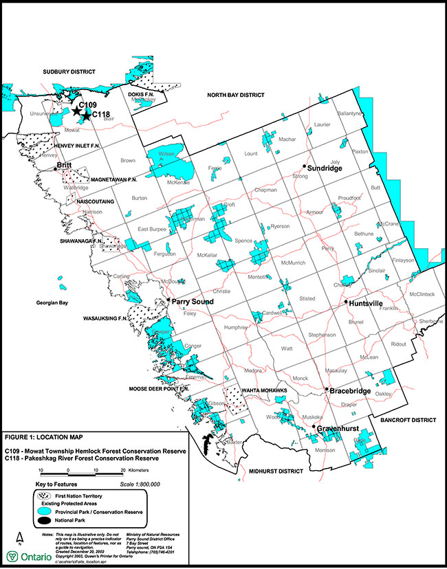
Figure 1: Location of Mowat Township Hemlock Forest and Pakeshkag River Forest Conservation Reserve
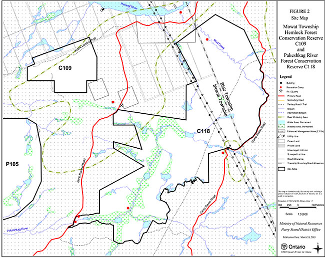
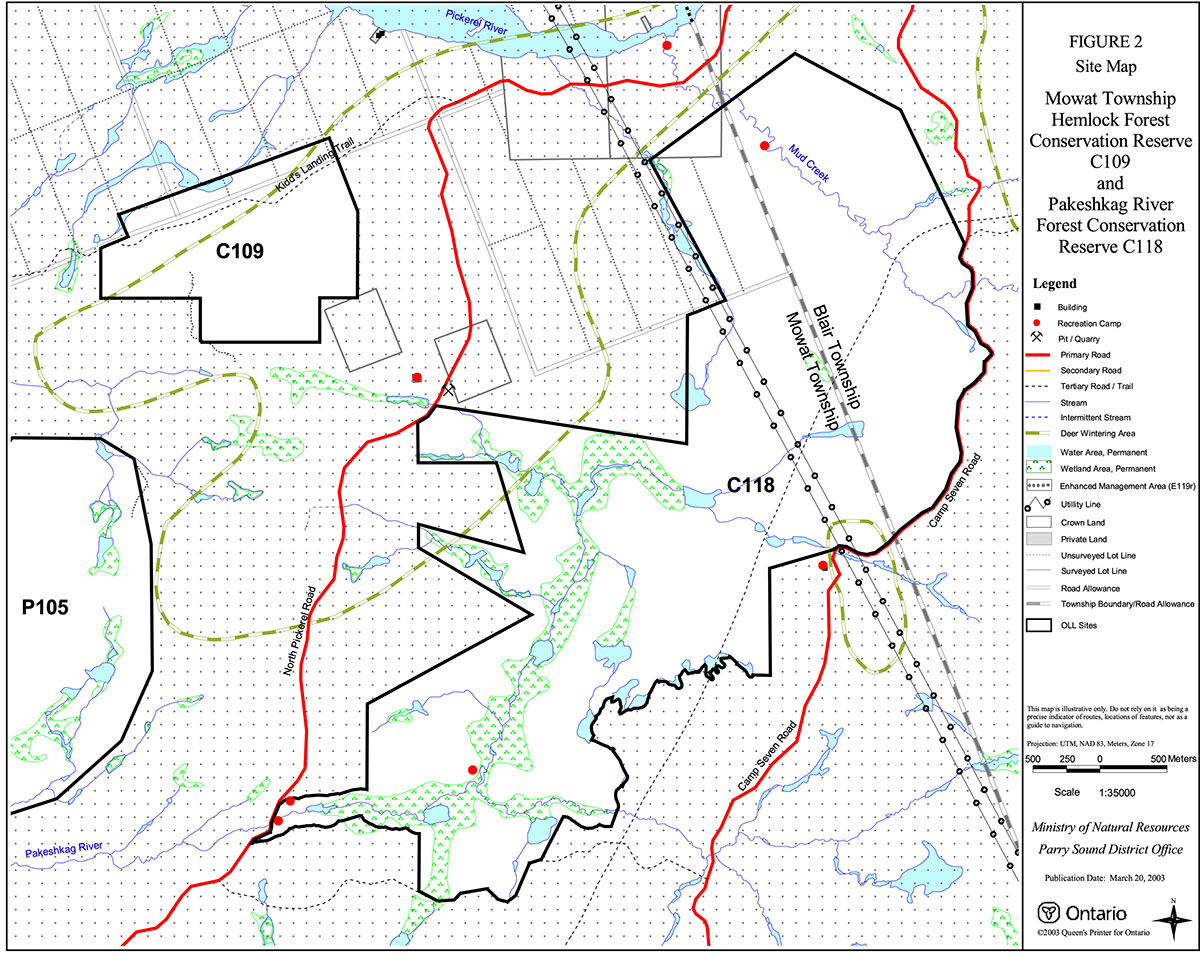
Figure 2: Site Map –Mowat Township Hemlock Forest and Pakeshkag River Forest Conservation Reserve