Nearshore community index netting instructions
Describes the standard methods and technical information necessary to conduct the nearshore community index netting field program.
Mark R. Stirling
Ontario Ministry of Natural Resources
Lake Simcoe Fisheries Assessment Unit
R.R. #2
Sutton West, Ontario
L0E 1R0
© 1999, Queen’s Printer for Ontario
Printed in Ontario, Canada
51268
(0.2K P.R., 1999 03 15)
ISBN 0-7778-8400-3
Copies of this publication are available from:
Ontario Ministry of Natural Resources
Fish and Wildlife Branch
P.O. Box 7000
300 Water Street
Peterborough, ON K9J 8M5
Cette publication specialisee n’est disponsible qu’en anglais
1.0 Introduction
Nearshore Community Index Netting (NSCIN) is a standard live release trap netting program designed to evaluate abundance and other attributes of fish species that inhabit the littoral zone of Ontario lakes. A properly conducted NSCIN program should, at a minimum, provide fisheries managers with mean catch and fish length data that can be used to make relative comparisons to provincial benchmark values from other lakes in Ontario. These benchmark values are presented in the Fisheries Assessment Unit (FAU) Network Report 1997-1 entitled “Nearshore Community Index Netting (NSCIN) in Ontario: Year 5 Update” (Willox et al. 1997). Additional netting effort can supply more precise mean catch estimates sufficient to statistically test for differences between years (trend through time analyses) or lake characteristics (habitat indices). This program also provides project leaders with an opportunity to collect additional fish attribute data (e.g., age, weight, etc.), which may be useful at the local level, and could lead to more meaningful provincial benchmark values when included in the provincial NSCIN database.
This manual describes the standardized methods and provides the technical information necessary for project leaders and field crews to conduct the NSCIN field program. Standard NSCIN data collection techniques have been designed to be compatible with the software package Fishnet2 provided by the Ontario Fisheries Information System (OFIS) of the Ontario Ministry of Natural Resources (OMNR).
The NSCIN program was originally developed for the FAU network of the OMNR to provide trend through time information on warmwater and coolwater fish species, that would be comparable with other FAU lakes. Field sampling was first conducted in 1991 on Lake Joseph and Lake Simcoe, in the south-central region of Ontario, and expanded to include 25 different lakes across the province by 1995. Many lakes were sampled more than once, providing a total of 47 NSCIN projects that were used to develop the current provincial benchmarks offish abundance and size classification. These benchmarks will be improved, and new benchmarks may be developed, as more projects are submitted to the provincial NSCIN database.
NSCIN may not be suitable for all lake or fish community types. The standard trap nets used are size selective. Small fish that are less than approximately 90 mm fork length can pass through the mesh, and extremely large fish may be excluded by the limiting 25 x 25 cm tunnel entrance. Lake size, littoral zone slope, and the amount of aquatic vegetation are just three factors that may limit the number of acceptable netting sites for the NSCIN standard trap nets. Anyone considering this standard netting program should familiarize themselves with this manual’s Gear Description (section 4.0) and Site Selection (sections 5.1 and 6.1) sections to determine if the NSCIN program is suited to the lake and fish community they wish to study. Examination of a lake contour map, or an actual visit to the lake, may be required to determine whether a particular lake is suitable for assessing with this program.
2.0 Survey design
A successful index netting program requires stringent standardization of gear and methods in order to reduce sampling variability. A study to assess fish abundance usually requires many netting efforts, but does not require the collection of fish attribute data. Conversely, a study to collect fish attributes is usually designed to obtain large catches offish from a minimal amount of netting effort. The objective of this program is to provide both an index of fish abundance and fish attribute data from one field survey program, such that the results are comparable between lakes and/or over time.
The NSCIN program was designed with consideration for the following criteria:
- Sampling should occur during a time when fish distribution is least affected by environmental conditions or fish behavior.
- The sampling gear should be standardized, effective at catching common nearshore fish species, relatively easy to move and set, and preferably non-lethal to the fish captured.
- The net setting criteria should be standardized while allowing for some versatility to accommodate different netting sites.
- Sampling sites should be selected in a spatially random fashion to avoid any biases in the site selection process (e.g., to avoid selecting sites that are closest to the lakes access point or sites that represent preferred habitat for a particular fish species).
To satisfy the above criteria, the following key components of the NSCIN survey design were selected:
- The field sampling season is from August 1st to whenever the surface water temperature cools to 13 degrees Celsius (usually late September in south-central Ontario).
- Each net set duration is approximately 24 hours (i.e., overnight sets).
- The sampling gear used is a standardized six-foot trap net (see section 4.2).
- Standard net setting criteria have been developed (e.g., water depths, minimum net separation distances, guidelines for reuse of sites, gear orientation from shore, etc.). The sampling specifications provide both target values and acceptable ranges (see sections 6.1 and 6.3).
- Sampling sites are randomly selected (see section 5.1).
Netting site descriptions, set descriptions, lift information, and fish catch information is documented separately for each netting effort on standard NSCIN data forms. Acronyms (in square brackets) identify Fishnet2 field names on all NSCIN forms to facilitate the data entry process. The acceptable ranges of the net setting criteria (in round brackets) are also included on the forms to provide a quick reference for field crews. The required data collection for each netting effort has been selected and designed to minimize observational error and subjectivity, without requiring an inordinate amount of field collection time.
In an attempt to explain catch variability, information about the sampling site substrate, available fish cover, and weather conditions is also recorded for each netting effort. All users of the NSCIN program should collect this information to improve the provincial NSCIN database. Eventually, these easily collected data elements may be useful in explaining catch variability and may provide new benchmark standards for comparisons between lakes and/or over time (e.g., compare catches from similar substrate or cover categories).
Substrate is categorized into one of six categories and all observed substrate types within the visible area 100 meters on each side of the net are documented. This approach allows for post-stratification by substrate category and could also allow for more detailed analysis by substrate composition. Actual quantitative measures of substrate (i.e., percent composition) were experimented with in the original NSCIN design, but these techniques were found to be very subjective and not repeatable. Less subjective techniques of assessing habitat were thought to be too time consuming for such a netting program. If substantial substrate information exists for a given study lake, then the sampling effort could be allocated to the different substrate categories based on their actual proportions in the lake.
Fish cover is categorized by how much cover is present (e.g., low, medium, high) and all observed cover types within the visible area 100 meters on each side of the net are documented. This approach allows for post-stratification by amount of cover and could also allow for more detailed analysis by cover types. Effects from weather are measured at each sampling site by recording temperatures, wave heights, cloud cover, precipitation, and wind when the trap net is sampled. A general weather observation is conducted to describe the conditions that occur at each site over the duration of the netting effort. These observations have been designed to be as descriptive and repeatable as possible, without requiring an inordinate amount of sampling time.
A crew of two people should be able to lift, process the fish, and reset at least two spring-haul trap nets per day. At that rate, at least 16 random sites could be sampled in 9 consecutive working days or in 2 standard 5-day work weeks. Time requirements are directly affected by travel distances (i.e., between sites and/or to and from the lake) and fish sampling targets (i.e., amount of fish caught plus the amount of fish sampling required). On small lakes with low to moderate catch rates, crews could likely handle up to 4 spring-haul trap nets per day.
Spring-haul trap nets cost about $2,250 to $2,500 each (see section 4.2), and should easily last 15 or more years ($150 to $167 per year). If gear costs are a deterrent to conducting NSCJN, trap nets may be available from other users of the NSCJN program. The FAU network has some standardized spring-haul trap nets available for others interested in conducting NSCJN studies.
3.0 Sample size
While sample size is affected by costs and other logistical considerations, appropriate sample size for assessing fish abundance depends on the purpose of the survey. If the purpose is to statistically test a hypothesis, then sample size should be chosen so that the test is performed at a reasonable level of power. Power is the probability of detecting a difference if it exists.
If the purpose of the survey is not to test a specific hypothesis, but to obtain estimates of fish abundance at a point in time (i.e., a “snap shot”), then sample size should be dictated by a desired level of precision in estimating the mean catch. For instance, a fisheries manager may want to know if a lake fits into a “good” or “bad” category for a certain fish species, compared to other lakes in the province. Relative comparisons based on such categories usually require less precision and therefore fewer net sets than most hypothesis testing analyses. When the number of samples per lake increases, the precision level increases. Therefore, the appropriate number of samples to collect (i.e., nets to set) depends on the purpose for doing the NSCIN program.
A minimum sample size of 16 sets per lake is recommended for making relative comparisons of fish abundance (i.e., comparing results to provincial benchmark categories). More sampling should be considered for relatively large lakes and spatial stratification may also be advantageous to reduce the logistical problems associated with long travel distances between sites. Based on within-year variability in catch from previous NSCIN projects, 16 sets per lake will usually produce (on average) a 95% confidence interval whose total width is approximately 100% of the mean. Increasing the sample size to 20 sets per lake should produce 95% confidence intervals that are approximately 88% of the mean.
A minimum sample size of 30 sets per lake is recommended where higher precision is required (e.g., FAUs statistically testing for differences between years or lake characteristics). For high precision targets, increasing the sample size to 30 sets per lake should produce 95% confidence intervals that are approximately 70% of the mean.
In addition to the number of sets per lake, it is recommended that NSCIN be conducted on each study lake for at least 2 consecutive years. Using the mean of two years greatly increases the chances of obtaining a mean catch value that more accurately reflects the actual population abundance, rather than a mean catch value influenced by unique weather conditions or some other phenomena that occurred during only one sampling period.
A detailed discussion of sample size is presented in the FAU Network Report 1997-1 entitled. “Nearshore Community Index Netting (NSCIN) in Ontario: Year 5 Update” (Willox et al. 1997).
4.0 Gear description
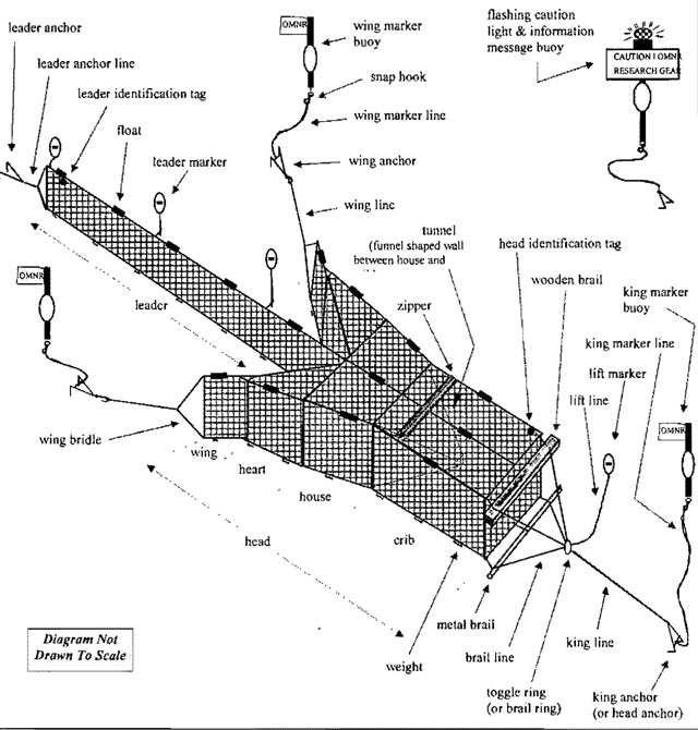
A trap net is a passive fishing device that entraps fish as a result of their own movement and subsequent reactions to the net. The net consists of two main parts, a leader, and a head. The leader, constructed of mesh netting, is designed to impede the normal movements of fish and subsequently lead fish out to the head. The head, also constructed of mesh netting, is designed to capture fish by funneling them into a box-shaped crib. The most common type of trap net used to conduct the NSCIN program is a spring-haul trap net. Spring-haul refers to the method of setting the net without the use of pulleys (down-hauling), lifting the net by bringing it in over the boat, and the location of the zipper near the house end of the crib. Down-haul trap nets may also be used, but are not recommended due to the extra rigging and net handling time required. For this reason, the gear requirements and net handling methodology presented in this manual are based on the spring-haul trap net (see Figure 1).
Figure 1: Spring-haul trap net
4.1 How fish are captured
Fish moving in the littoral zone often travel parallel to shore and lake bottom contours where they encounter the trap net leader that is set perpendicular to shore. Very small fish may pass through the mesh leader, while larger fish swim around or away from the obstacle. Other fish may actually be attracted to the net as it offers a source of cover, and some fish may be attracted to fish already trapped in the net. Eventually, some of these larger fish will encounter the heart or wing of the trap net. To follow the heart, wing or leader away from the net requires that the fish swims back towards shore. Alternatively there is a gap between the leader and heart. Fish that pass through the gap enter into the heart and house of the net where they may continue to move about. Due to the shape and location of the gap opening created by the trap net hearts, fish rarely encounter the gap opening at the appropriate angle to exit the nets enclosure. The funnel-shaped tunnel at the back of the house gradually leads fish into the narrow restricted end of the tunnel where there is another opening. Fish dart through the final tunnel opening and into the crib. Once trapped in the box-shaped crib, the only available escape route is the tunnel opening suspended in the middle of the crib. Due to the shape and location of the tunnel, fish following the crib walls rarely encounter the tunnel opening and thus rarely escape.
The entire net must be set properly in order for fish to successfully make the journey along the leader, through the gap, through the tunnel, and into the crib. A proper set requires that the leader is relatively straight, tight, and not twisted. The gap opening must be held open by the heart and wings that are relatively tight, at proper angles, and not twisted. The sides of the heart and house should be taut. The tunnel must be clear of obstructions and suspended in the crib. There must not be any holes in the mesh netting that will allow fish to escape from any area of the net. The net should be well secured with anchors to prevent wind and wave action from loosening the net and thus reducing its efficiency.
4.2 The standard NSCIN trap net
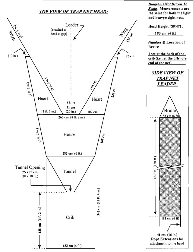
Any trap net (e.g., spring-haul or down-haul) used to conduct the NSCIN program should conform to the standard set of specifications. These standard mesh sizes, colours, measurements, etc., are provided on the following two Standard Trap Net Description Forms (see Figures 2 and 3). Mesh size and colour should be identical to the NSCIN standards. Net dimensions should be within at least 10 percent of the standards. If your trap nets do not conform to these standards, then your fishing results will not be valid for comparative purposes.
The spring-haul NSCIN trap net can be constructed using either heavyweight or lightweight materials. The lightweight net is less bulky and about 18 percent lighter and may be preferred for lakes where access is more difficult (e.g., fly-in or portage access lakes) or when smaller boats are being used. The heavyweight net is likely more durable and is recommended for more severe conditions when strong winds and hard lake bottoms can result in greater net wear.
The lightweight trap net is about 10 percent cheaper to build at approximately $2250, while the heavyweight net costs approximately $2500 (as of 1996). Two net builders in Ontario that can supply these specific NSCIN trap nets are:
Niagara Netting
1838 Port Robinson Road
RR #1 Port Robinson, Ontario
L0S 1K0
(905) 384-9807
Net Builder: Mr. John Radford
Superior Net and Twine Company
2095 B Paquette Road
Thunder Bay, Ontario
P7B 5E2
(807) 767-4064
Net Builder: Mr. George Sameluk
The specifications in the following Standard Trap Net Description Forms provide the information necessary to build either version:
Figure 2: Standard specifications for NSCIN trap nets - form 1
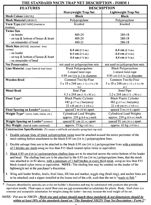
Figure 3: Standard specifications for NSCIN trap nets - form 2
5.0 Pre-field activities
Before beginning the field work, the following activities should be performed to ensure that the field crew is properly prepared.
5.1 Random site selection
Prior to the random site selection process, field crews may want to visit the lake or examine lake contour maps and/or aerial photographs to eliminate littoral zone areas that are definitely not suitable for setting trap nets (see section 6.1). This technique can save the field crew a considerable amount of time, as they will not be traveling long distances to obviously unsuitable locations (e.g., too deep, too shallow, marine hazard, etc.). Be careful not to eliminate areas that are marginal, as the sampling specifications do allow some flexibility and site conditions will often vary depending on seasonal water levels and recreational activity.
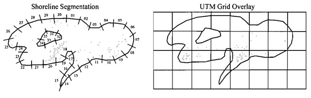
The first step in the site selection process is to partition or divide the shoreline into sampling sites or units. Two common methods include dividing the shoreline into equal length segments or delineating sites based on the boundaries of Universal Transverse Mercator (UTM) grids.
The shoreline segment method requires some preparation time to measure, draw, and number the equal length segments on a lake map (see Figure 4). On large lakes, this task can be quite time consuming. The length of the segments must be determined such that there are enough segments to allow for the required number of net sets, each segment provides some leeway within the site for net placement, and the segments are at a workable scale. For Fishnet2 data entry compatibility, segment numbers should not exceed 4 characters in length. Common shoreline segments used on previous NSCIN projects range from 100 to 250 meters in length.
The UTM grid system is provided on both Topographic Maps (Canada Department of Energy, Mines and Resources) and Ontario Base Maps (OMNR). The UTM grid system is geographically referenced, which can simplify the process of transferring the netting sites and associated data into a Geographic Information System (GIS). Use of UTM grids will result in netting sites of different sizes, depending on the shoreline orientation with the UTM grid system (note the different lengths of shoreline in each grid on the island in Figure 4). UTM grids are 1000 meters or 1 kilometer long on each side of the grid. The UTM grids may be divided into smaller sub-grids which are more suitable for the size of waterbody being sampled (e.g., 4 sub-grids500 m per side, 16 sub-grids 250 m per side, 100 sub-grids 100 m per side). A convenient method to divide a UTM grid is to use a clear plastic overlay sheet with the sub-grid boundaries marked on it. The grids or sub-grids that actually overlay or intersect the lake shoreline must be labeled with a numeric code and recorded on a list for the random site selection process. For Fishnet2 compatibility, the numeric codes used to identify grids and sub-grids should not exceed 4 characters in length. The NSCIN Fishnet2 data template can be modified to accept a 12 character coordinate in a data field called SILOC, and the Area #, Grid #, and Site # fields on the NSCIN Effort/Catch Form provide enough space to record these coordinates. However, use of the three Fishnet2 fields, Area, Grid, and/or Site, appears to be the most common method to record NSCIN trap net locations.
Figure 4: Random site selection by shoreline segments and UTM grid overlay
The second step of the site selection process is to randomly select the appropriate amount of numbered segments or numbered grids (or sub-grids) using a random table of numbers. Randomly selected sites can then be used to prepare a sampling schedule that will direct the field crew about which sites to use on each sampling day. Remember to select more sites than the target number of net sets, as some sites may be unsuitable when visited in the field, and alternate sites may be required. Avoid selecting the same site more than once (i.e., make selection without replacement) unless the number of useable sites on your lake is severely limited. If the same site is selected more than once and when preparing the sampling schedule, keep in mind that a trap net must not be reset within 500 meters of where it or any other trap net was set over the previous 48 hour period (see section 6.1 ).
Project leaders should provide the field crew with copies of both the lake map and sampling schedule for field use- where the field crew will ultimately determine the specific netting location.
5.2 Fish sampling requirements
The minimum fish sampling required for the NSCIN program is to record the number of fish caught per species per net, and the associated fork length class (10 mm size classes) from as many of the fish as possible. Ideally, all fish should be measured and length classed by species from each net sampled. Sometimes, exceptionally large catches are encountered that require too much processing time. In these cases, after randomly length classing a predetermined (by the project leader) minimum sample size, (e.g., 300 fish per species per lift), the remainder of the catch for that species would be counted only. Therefore, the number length class tallied, plus the number counted only, would be added together to calculate the total catch, for that species, from that particular net set. This information should provide fish abundance and fish size information that can be compared to the NSCIN benchmark values from other NSCIN projects.
One of the benefits of this program is that after collecting the above fish information, other fish attributes can also be sampled. It is highly recommended that project leaders also plan to collect some weight, age, and more precise length data. This additional data can provide a clearer picture of the fishery being sampled by providing a host of other indicators (e.g., mortality, growth, condition, age structure, etc.). Also, there is a need for more fish age and weight data to be submitted to the provincial NSCIN database to develop potentially more meaningful benchmark values.
There may not be enough time for field crews to collect all this additional data, from all the fish captured, while handling two to four nets per day. Therefore, most field crews sub-sample their catch to reduce the number of additional samples required per net and yet provide a suitable number of weights, ages, etc.. The most common method of sub-sampling tends to be size stratification for species of interest. Project leaders identify which species to collect the additional information from and then identify a quota of samples required by size class. If for example, a quota of 15 smallmouth bass per size class were sampled across the duration of the program (i.e., all catches combined) for weight and age data, and quotas were filled from 10 different size classes, then a total of 150 weight and age samples would be available for further analysis.
Prior to beginning the NSCIN field work, project leaders should determine what (if any) additional fish attribute samples (e.g., weights, age tissue, etc.) will be collected from which fish (i.e., Which species to sample? Use size stratified sampling? If size stratifying, what should the quota per size class be? What is the best size class interval to use?). Be careful when developing a fish sampling regime for additional attributes that your sampling method does not introduce a sampling bias. Do not rely on the field crew’s ability to select a random sample from the net or fish holding tub. A good sampling regime should provide representative samples from the entire size range offish captured. Document your sampling regime to provide clear direction to the field crew. Determine where the field crew will record this data (e.g., scale envelopes) and how they will keep track of any sampling quotas (e.g., additional attribute summary forms or tally sheets).
The appropriate sampling regime (i.e., species to sample, age tissue to collect, precision of lengths and weights, size class quota, size class interval) for additional fish attribute data depends on the unique concerns the project leader has for each particular lake. This manual does not attempt to instruct project leaders about what additional information to collect or how to collect it. However, considering the expense of conducting any field project, it is highly recommend that this opportunity for data collection should not be overlooked.
5.3 Preparing a public information sheet
If working on a lake with extensive shoreline development, it is a good idea to prepare an Information Sheet to give to property owners and other members of the public when encountered near your sampling sites (see Figure 5). Public Information Sheets can be left on docks or between doors of residents that appear to be away for the day. These Information Sheets tend to satisfy most people’s curiosity and significantly reduce the occurrence of negative reactions which can lead to net tampering or unnecessary complaints.
In some cases, project leaders may want to contact local interest groups (e.g., cottage associations, First Nations, angler groups, etc.) prior to conducting the field program, to inform them about the NSCIN program that will be taking place on the lake.
A typical Information Sheet or contact letter should identify who is conducting the NSCIN program, why, for how long, and provide a telephone number to contact for more information. Be sure to mention that NSCIN is a live release program.
Figure 5: Example of a public information sheet
[Reproduced text below]
5.4 Preparing the field forms
Prior to the first field sampling day, crews will need to prepare enough NSCJN Effort/Catch Forms and NSCIN Length Class Tally Forms to record their results while in the field (see sections 6.3, 6.5, and 6.7). One Effort/Catch Fonn and several Length Class Tally Forms will be required for each net set. Blank copies of these standard NSCIN forms, and tips on photocopying and printing, are included at the back of this manual in the Forms section.
If additional fish sampling is required (e.g., scale samples, weights, etc.), then the appropriate paperwork for that task should also be prepared at this time. All paperwork (forms, manual, maps, schedule, scientific collectors permit, information sheets, scale envelopes, etc.) should be placed in plastic bags and sealed in a suitable storage container for protection from wind and water damage.
NSCIN forms can be printed (laser printers only) or photocopied on weatherproof or waterproof paper for working in inclement weather. It is recommended that a small set of weatherproof or waterproof forms be made available to the field crew for the days when such forms would be required. A supplier of both weatherproof photocopy paper (“Rite in the Rain" Copier Pak@ $18.75 US/200 sheets) and waterproof photocopy paper ("Rite in the Rain” Dura-Copy@ $52.45 US/100 sheets) is the J.L. Darling Corp., 2614 Pacific Highway East, Tacoma, Washington, USA, 98424-1017 (253) 922-5000.
5.5 Equipment list
The following gear should be checked, serviced, and organized in preparation for the field activities:
- Standard NSCJN trap nets (see section 4.2)
- Trap net anchors (4 per net- 1 king, 2 wings, and 1 on leader+ 1 for caution/info. buoy)
- Marker buoys (5 to 6 per net- 1 king, 2 wings, and 2 to 3 along leader)
- Flashing caution light and information buoy (light used to warn boaters during poor visibility)
- Snap hooks (optional- to attach marker buoys &/or wing anchors)
- Plastic cable ties (to sea/the trap net zipper)
- Sounding line (at least 5 m long with 0.1 m graduations)
- Depth sounder (optional - simplifies the site selection process)
- Thermometer (attach 1 m string if using a hand held model for water temperatures)
- Tete-thermometer (pptional- excellent for water temperatures)
- Compass (to measure wind direction)
- Anemometer (optional- provides accurate wind speeds)
- Dip net (recommend a fine knotless mesh to capture small fish)
- Fish holding tuh (fish packers, large coolers, or mesh holding pens work well)
- Pail (recommend 10 litre plastic pails- for filling & cmptying the fish tub)
- Fish measuring board [metric)
- Cotton gloves (assists fish handling and protects hands while pulling nets and anchor lines)
- Measuring tape (back-up for measuring board -long enough to measure large.fish)
- Net twine ( # 15 treated black nylon twine -for minor net repairs)
- Twine shuttle (net needle) (.optional- simpflifies net mending process)
- Spare rope (0.95 cm (3⁄8 in) polypropylene 3-strand twist)
- Spare batteries (for caution lights, depth sounder, tele-thermometer, anemometer, etc.)
- Knife &/or wire cutters (to remove the plastic cable ties which seal the trap net zipper)
- Watch
- Clipboard
- HB pencils (recommend several pencils & a pencil sharpener)
- NSCIN Manual Of lnstructions
- NSCIN Effort/Catch Forms (one per net set)
- NSCIN Length Class Tally Forms (both small and large fish sizes, several per net set)
- Sampling schedule (list of randomly selected /rap net sites)
- Sampling lake map (with trap net site boundaries, i.e., shoreline segments or UTM grids)
- Fish identification reference key (optional- may assist inexperienced crews)
- List of user designed fish acronyms or OMNR fish species code numbers (optional)
- Storage box and plastic bags (to protect forms and other gear from water damage)
- Boat/Outboard motor/Gasoline/Safety equipment (as appropriate for the waterbody)
- Optional fish sampling equipment (knives, scale envelopes, weigh scales, weigh bags, etc)
- Personal gear (rain suit, rubber boots, sun block lotion, hat, sun glasses, lunch, etc.)
5.6 Rigging the trap net
Before selecting any trap net for use in NSCIN it must be checked to ensure that it conforms to NSCIN standards. NSCIN Trap Net Description Forms (see Forms section) should be completed for each trap net and compared to the Standard NSCIN Trap Net Description (see section 4.2). Mesh size and colour should be identical to the standard NSCIN trap net. Net building is a hand craft that results in slight variations between nets, however, all net measurements (except mesh size) should be within at least 10 percent of the NSCIN Standard Trap Net Description. Both the leader and head should be labeled with a unique identifier to ensure that the performance of each net can be tracked and its history of use and repairs documented.
Before using the trap nets in the field, the nets must be inspected for any rips or holes in the mesh. Minor repairs to the mesh and lashing can be made during the pre-field inspection using size 15 treated black nylon twine. Spring-haul trap nets should come from the supplier complete with wood and metal brails, braillines, toggle ring (brail ring), lift line, lift marker, king line, leader bridle, wing bridles, and wing lines (see Figure 1, section 4.0). If any of these parts are missing from the net, they can be attached during the pre-field inspection using polypropylene 3- strand twist rope, 0.95 cm (3⁄8 in.) in diameter. Make sure the rope used on the wing lines will float when not submerged by an.anchor. The above mentioned polypropylene is good for this purpose.
Marker buoys, snap hooks, marker lines, anchors, yellow flashing lights, information message signs or flags, identification tags, and leader markers are usually manufactured and purchased separately from the rest of the trap net (see Figure 1, section 4.0). Also, most of these items (except identification tags) are not attached to the net until it is being set in the water. The king anchor and wing anchors should be rigged prior to field use by attaching the marker lines and then wrapping the marker line around the tines of the anchor. Optional snap hooks can be rigged at this time and used in the field to attach wing anchors and marker buoys. These quick release snap hooks will make attaching and removing these items faster and simpler. On large bodies of water, it may be necessary to attach a steel thimble to a braided loop in the rope where the snap hook is repeatedly attached. This will provide protection from the chafing that occurs between the metal snap hook and the rope caused by the movement of the wave action. An information message, identifying the nets owner, address, and contact telephone number, should be prepared in the fonn of a sign or flag attached to a highly visible marker buoy. To warn boaters traveling in poor visibility conditions (e.g., in fog or at night), a flashing caution light can be attached to the information message buoy. The flashing light should be pre-assembled, tested, and affixed to the information buoy. On large bodies of water, the bulky flashing light and message buoy should be rigged to be anchored separately, such that the extensive wave action on this buoy will not affect the net set. The light sensitive switch on the flashing light can be turned off until the first day of use. Lastly, the net’s zipper should be closed and sealed (plastic cable ties work well) prior to packing the net for transportation to the lake. These ties prevent the zipper from coming undone accidentally and indicate if tampering has occurred.
When packing or setting a spring-haul trap net, the standard procedure is to ensure that the wooden brail is at the bottom of the bundle and is closest to the shore (i.e., “wood to shore”). This practice ensures that the head will not be accidentally set upside-down after setting the leader.
5.7 Training
This manual describes the techniques and provides the infonnation necessary to conduct the. NSCIN field program. However, to successfully perform this survey, at least one of the field crew members should have the following skills and knowledge:
Safe boat operation
This program requires a host of safe boating skills and knowledge to successfully maneuver the boat while setting and lifting trap nets, and to navigate between netting sites. Such tasks involve operating a vessel, often very close to shore, and often near its maximum load capacity, while coping safely with the effects of inclement weather and high waves. While setting the trap net, the boat is often reversed with the transom traveling directly into large on-shore waves which, if large enough, can swamp the boat. Therefore, extreme care, good judgment, and safe boating practices should be exercised at all times. This manual does not include safe boating instructions nor does it attempt to identify the legally required marine safety equipment.
First aid
As with any field project, professional medical services are seldom close by. Therefore, all staff should receive standard first aid training before beginning their field work. Likewise, all crews should carry a fully equipped first aid kit.
Knowledge of applicable laws
This program involves both fishing and boating activities that require knowledge of a variety of legislation. These include, but are not limited to, the Canadian Fisheries Act, Fish and Wildlife Conservation Act, Canadian Boating Regulations, Trespass To Property Act, etc. Field crews should be fully aware of their responsibilities with issues such as Scientific Collectors Penn its, setting nets that may interfere with boat traffic, speed limits on lakes, proper safety equipment required aboard a vessel, etc..
Fish identification
It is essential that field crews are able to identify the fish they capture. Project leaders should take the time before field work begins to ensure that the field crew can identify the fish species that are likely to be caught. A reference identification key may be a useful tool to include in the crew’s field gear. If a unique species is encountered that is new to the lake or difficult to identify, then a reference sample could be collected.
6.0 Field procedures
These standard procedures must be followed to properly conduct the field portion of the NSCIN program.
6.1 Site selection
Use the sampling schedule and lake map prepared in section 5.1 (Random Site Selection) to determine where and when to set each trap net. On reaching the predetermined random site, assess whether the location is suitable by observing the area for marine hazards (e.g., high traffic area, swim area, dock access, etc.). If the site is free from marine hazards, then measure the water depth at a distance offshore approximately equal to the length of the trap net leader. Use the water depth and offshore distance values to determine whether this random site is a suitable sampling location as per the following NSCIN criteria:
Table 1: NSCIN Sampling Specifications
| Criteria | Target | Acceptable |
|---|---|---|
| Trap Net Separation Distance | 500 m (1640 ft.) | 500 m (1640 ft.) |
| Reuse Of Trap Net Sites | no reuse of sites | after 2 nights net free |
| Trap Net Set Duration | 24 hours | overnight (usually average - 22 hrs.) |
| Leader Length In Water | 46 m (150 ft.) | 30 to 46 m (100 to 150 ft.) |
| Leader To Shore Distance | 0 m | 0 to 20 m (0 to 65 ft.) |
| Leader Angle From Shore | 90 degrees | 70 to 90 degrees |
| Leader Start Depth | 0 to 0.3 m (0 to 1 ft.) | 0 to 1.0 m (0 to 3 ft.) |
| Water Depth At Gap | 2.0 to 2.5 m (6 ½, to 8 ft.) | 1.7 to 3.5 m (5 ½, to 11 ½, ft.) |
Refer to the Set Description portion of section 6.3 (Information To Record At Set) for a detailed description of the last 5 net setting criteria from Table 1.
If the site is not suitable then use a predetermined method to select an alternate site. An alternate site selection method must not introduce a bias to the selection process and should be easy to execute. A common method is to assess the two adjacent sites, and if neither of these is acceptable, then go to the next closest randomly selected site that is a suitable distance away from any other sets. A trap net must not be reset within 500 meters (1640 ft.) of where it or any other trap net was set over the previous 48 hour period (i.e., after 2 nights net free). This is to eliminate over-fishing an area by providing at least a 2 net-night break from sampling the same lake area.
6.2 Setting the net
- Survey the site to ensure that you are aware of all obstacles that may affect the trap net set. Estimate 46 meters (150 ft.) offshore and measure the water depth there with a graduated sounding line or depth sounder to determine a suitable placement for the trap net gap. Use the offshore distance and water depth measurement to develop a net setting plan which will ensure that the trap net will be set within the acceptable NSCIN sampling specifications, and as close to the target specifications as possible (see section 6.1).
- For a new set, with the spring-haultrap net laying “wood to shore” across the bow of the boat, untie the rope that was used to pack the net bundle during transportation and use this rope to attach the leader anchor to the shore end of the leader. If resetting, the leader anchor will still be attached from the previous set. To reset, the trap net does not have to be orientated across the bow, but rather it can be reset out over the side of the boat (the reverse of how it was retrieved).
- Set the leader anchor as close to shore as possible such that the gap will be located within the target or acceptable depth ranges. Set the leader by reversing the boat away from shore while maintaining a course that is as close to perpendicular from shore as possible. Guide the leader material out to ensure that it does not get twisted, tangled, or snagged on the boat. In some cases, the leader can be tied directly to a tree or stump along the shoreline- however, this method should only be practiced on Crown Land.
- Once the leader is set, check the water depth before setting the wings to ensure that the gap will indeed be set within the acceptable depth range. If the depth is unacceptable, retrieve the leader and adjust the leader anchor accordingly. If the depth looks good, throw the wings out on their appropriate sides of the leader and as far out as possible to avoid any chance of tangling. Ensure that the wing Jines are floating freely as they must be retrieved later in the net setting process.
- Continue to reverse the boat while letting out the remainder of the trap net head. When it is time to let out the brails, make sure the braillines are free from tangles and not looped an extra turn or two around the ends of the brails. While holding the four brails lines, this is a good time to double check that the zipper is indeed closed and sealed. If all looks good (i.e., no tangles, zipper sealed), ease the brails into the water and grasp the king line.
- If the lake bottom is at all rough and not conducive to allowing the head to slide along the bottom - then this is a good place to carefully pull the net tight, in a straight line, while the head is being pulled up off the lake bottom. Carefully use the power of the reversing boat in combination with a few strong arm pulls to achieve a taut set.
- With king line in hand, double check that the king line knot at the toggle ring (brail ring) is secure, and throw out the lift marker and line ensuring that it too is not tangled as this marker must be floating for future retrieval. If setting the net for the first time (i.e., not resetting)- then this is a good time to attach the king anchor to the offshore end of the king line. A clove hitch with a locking half hitch is recommended for securing the king anchor. Attach the king marker buoy to the king marker line with a secure knot or optional snap hook and unravel the marker line from the tines of the king anchor so that the whole rig can be dispatched without any interruptions.
- While maintaining some tension on the king line, continue to reverse the boat and let the king line out. When you reach the king anchor, carefully pull the entire net tight so that the leader float line, head center line, and king line all fonn one long straight line.
Note: On some boats, this pulling can be done by hooking the anchor tines inside the front bow and letting the carefully controlled reversing boat motor do all the work (be prepared to release the anchor by lifting the king marker line). Otherwise, the crew member will have to hold the anchor while their partner carefully reverses the boat. When using a low powered motor, the motors weak reverse thrust can be improved by surging the boat back and forth. With a firm grip on the anchor and your feet well planted, while the boat motor is thrusting backwards, pull the anchor towards you about an arms length, and then relax letting the motor surge backward with the slack rope you created, until the rope pulls tight again. Continue this procedure until the boat’s momentum has pulled the net tight and straight. Be careful, this surging technique requires sure footing, good balance, and a strong back - boat drivers must always pay close attention to the net setter and be prepared to quickly reduce the amount of reverse thrust.
- When the net is tight and straight, continue to slowly reverse while letting the anchor sink to the bottom by carefully letting out the king marker line. Ensure that the king anchor does not get flipped upside-down while being lowered if you are using one-sided anchors. When the anchor hits bottom, give it a couple of tugs in order to drag it back along the bottom as far as possible before releasing the marker line with the marker buoy attached.
Note: If the reverse tugging method does not result in a tight set, then the king line may be tightened at the toggle ring (brail ring) by dragging the anchor towards the net, so that the anchor tines will dig in or get caught on something. This method is sometimes necessary in lakes with extremely soft or hard bottoms (i.e., the anchor tines fail to dig into the substrate or the substrate in not stable enough to hold the tines). Be careful not to lift the toggle ring (brail ring) too high when untying the king line knot. Pull the king line through the toggle ring (brail ring) until the net is tight and then re-tie the king line. Be careful not to drag the king anchor too close to the net- long king lines are usually more helpful in poor anchoring situations.
- While traveling to the wing line, prepare a wing anchor by unraveling the marker line from the anchor’s tines and attach the marker buoy with a secure knot or snap hook.
- Retrieve one of the floating wing lines with the boat orientated so that you can reverse away from the gap/wing area at about a 45° angle towards shore and away from the leader (i.e., extend the wing away from the net). Pull the wing line and wing mesh to the water’s surface to ensure that the wing is not twisted or tangled. If the wing is not twisted, attach the wing anchor to the wing line using either a clove hitch with a locking half hitch or a large, heavy load snap hook.
- Reverse away from the net while lowering the wing anchor by means of the marker line so that the anchor is dragged along bottom until the wing is snug. Ensure that the anchor does not get flipped upside-down and be careful not to over pull this line as it can sometimes pull the head out of shape and cause a slack leader.
- Repeat steps 10 to 12 for the other wing.
- Carefully approach the net near the gap to verify that the net is properly set. Ensure that the leader is not slack or bowed. The wings should be tight and at the correct angles such that the gap opening in not restricted. The house and crib should form a box that is not collapsed or slack on any side. If adjustments are required, the leader and head can usually be straightened and/or tightened by pulling the king marker line and resetting the king anchor. A wing can be adjusted by simply dragging the wing anchor to the correct location by pulling on the wing marker buoy.
- The trap net can now be classified as set and fishing. Note the set time. While at the gap, take this opportunity to accurately measure the gap water depth with a graduated hand line. Continue by attaching or setting any extra markers (i.e., leader markers and flashing caution light with information message) and then measure, observe, and record the appropriate net set information (see section 6.3).
6.3 Information to record at set
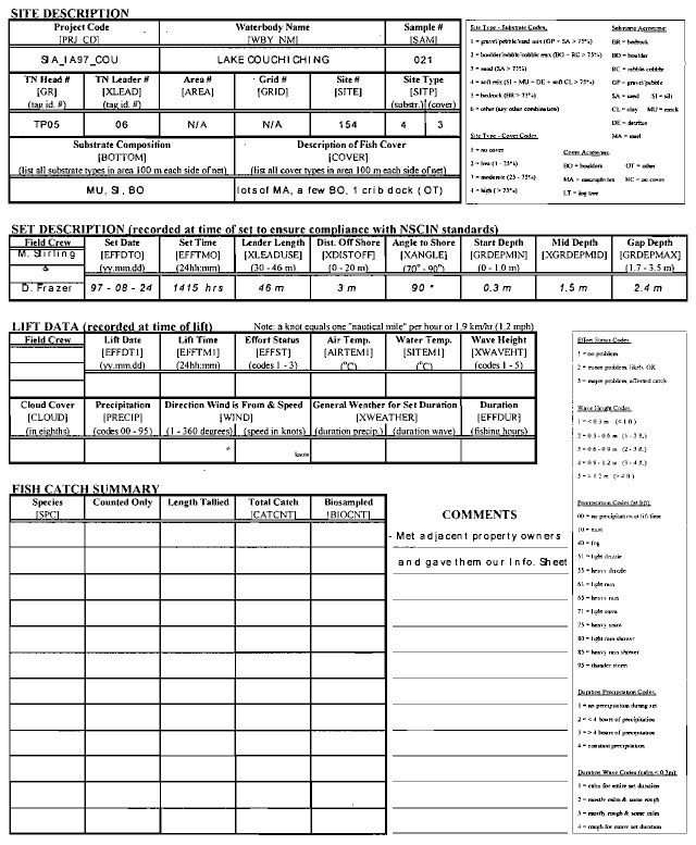
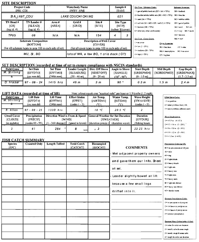
Net set information is recorded in the field with an hb pencil on the standard NSCIN Effort/Catch Form (see Figure 6). For each trap net sampling effort, one Effort/Catch Form is completed to document: The site description; the set description; the lift data; the fish catch summary; and comments. The first part of this form is filled out at the time of set, while the remainder of the form is used on the following day to record the lift and catch data. The acronyms in square brackets on all NSCIN forms correspond to the data entry field names in Fishnet2. The set information should be completed on the NSCIN Effort/Catch Form as follows:
Site description → These 11 fields identify which net was set, and where.
- Project code [PRJ_CD]
- Record the unique project code that has been assigned to your NSCIN project. Project codes are created by combining the Fisheries Office acronym, the Project Type acronym (IA for index adult with NSCIN with the Year, and the user defined Project Identification code or acronym (e.g., SIA_IA97_COU).
- Waterbody name [WBY_NM]
- Record the official name of the waterbody in which the trap net was set (e.g., Lake Couchiching).
- Sample # [SAM]
- Record the sequential fishing effort number that refers to each particular net set (i.e., the first set of the project would be Sample # 001, and the next set would be Sample # 002).
- TN Head # [GR]
- Record the trap net head identification tag number or code that specifies which head was set (e.g., TP05).
- TN Leader # [XLEAD]
- Record the trap net leader identification tag number or code that specifies which leader is attached to the trap net head (e.g., 06).
- Area # [AREA]
- Record the number or code (field length equals 2 characters) used to define the area of the waterbody (e.g., sector 03). This field is usually only used on large lakes that are spatially stratified. If the waterbody is not spatially stratified, record N/A to indicate that this field is “not applicable” to this project.
- Grid # [GRID]
- If using the UTM grid method of shoreline partitioning, record the UTM reference number (field length equals 4 characters) used to identify the specific geographic location of the netting site (e.g., 0802). If not using the UTM grid method, record N/A to indicate that this field is “not applicable” to this project.
- If using the UTM grid method of shoreline partitioning, this field can be used to record a sub-grid location within the larger UTM grid reference number recorded in the above Grid # field (e.g., C13). If using the UTM grid method without any sub-grids, then this field may not be applicable. Record N/A if Site # is “not applicable” to your project.
- Note: The NSCIN Fishnet2 data template can be modified to accept a 12 character coordinate in a data field called SILOC. The Area #, Grid #, and Site # fields on the NSCIN Effort/Catch Form provide enough space to record these coordinates. However, use of the three Fishnet2 fields, AREA, GRID, and/or SITE, appears to be the most common method to record NSCJN trap net locations.
- Site # [SITE]
- If using the shoreline segment method of shoreline partitioning, record the segment number (field length equals 4 characters) used to identify the specific geographic location of the netting site (e.g., 154).
Site type [SJTP]
Record the substrate code and cover code that best describe the lake bottom materials and availability of fish cover for the visible area 100 m (328 ft.) on each side of the net. If water clarity is limited such that you can not see the lake bottom out to the depth of the - trap net gap, then describe the site based on the limited observations available in the shallow water and/or use terrestrial indicators (e.g., emergent vegetation, shoreline substrate, etc.). Note any limited visibility situations in the comments section of the Effort/Catch Form. Use the following Site Type - Substrate Codes and Site Type - Cover Codes as found on the NSCJN Effort/Catch Form to categorize the area in which the trap net is fishing:
Site type - substrate codes:
- 1 = gravel/pebble/sand mix
At least 75% of the area must be represented by a combination of gravel/pebble and sand mixed together. If sand alone makes up more than 75% of the area substrate, then use code number 3 (sand). - 2 = boulder/rubble/cobble mix
At least 75% of the area must be represented by boulder or rubble/cobble or any combination of these two substrate types. - 3 = sand
At least 75% of the area must be represented by sand substrate only. - 4 = soft mix
At least 75% of the area must be represented by silt or muck or detritus or soft clay or any combination of these four substrate types. - 5 = bedrock
At least 75% of the area must be represented by bedrock substrate only. - 6 = other
At least 75% of the area must be represented by a substrate type or a combination of substrate types that do not fit into any of the above five categories (e.g.,> 75% marl or 30% bedrock & 30% sand & 40% muck).
Site Type - Cover Codes:
- 1 = no cover
The area does not provide any cover for fish. - 2 = low
1 to 25% of the area provides cover for fish. - 3 = moderate
25 to 75% of the area provides cover for fish. - 4 = high
More than 75% of the area provides cover for fish.
Substrate acronyms:
- BR = bedrock
Exposed bedrock with no overburden (i.e., solid bedrock, not individual rocks). - BO = boulder
Large rocks estimated to be over 25 cm (10 in.) in diameter. Visualize rocks larger than volleyballs. - RC = rubble/cobble
Stones estimated to be 8 to 25 cm (3 to 10 in.) in diameter. Visualize stones ranging in size from tennis balls to volley balls. - GP = gravel/pebble
Small stones estimated to be 0.2 to 8 cm (1112 to 3 in.) in diameter. Visualize stones smaller than tennis balls. - SA = sand
A grit like material of crystalline rock origin estimated to be less than 0.2 cm (1112 in.) in diameter, but large enough to be palpable as grit. Sand feels gritty and settles quickly in water. - SI = silt
A fine inorganic material of various origins, but not palpable as grit and without a greasy or sticky feel. Silt is like a very fine powder, almost impossible to mold or feel in the water, but when dried it has a floury feel. Silt is easily stirred-up in the water where it remains suspended for a considerable length of time. - CL = clay
A very fine material of inorganic origin with a greasy or sticky feel and often a moldable plasticity. - MU = muck
A soft material consisting of well-decomposed organic matter intermixed with mineral matter such as silt and clay, but not sand or gravel. Muck is dark in colour, often gaseous, and feels like a very soft mud. - DE = detritus
An organic material in which large pieces of sticks, leaves, decaying aquatic plants, etc. form at least 85% of the total mass. Detritus is like partly decayed compost. - MA = marl
A calcareous material composed principally of carbonates derived from mollusk shells and the photosynthetic activity of algae. It is primarily light gray in colour. It is not a widely distributed substrate type.
- Substrate Composition [BOTTOM]
- Record a list of all the substrate types identified within the visible area 100 m (328 ft.) on each side of the net. If water clarity is limited such that you can not see the lake bottom out to the depth of the trap net gap, then describe the site based on the limited observations available in the shallow water and/or use terrestrial indicators (e.g., emergent vegetation, shoreline substrate, etc.). Note any limited visibility situations in the comments section of the Effort/Catch Form. The following substrate descriptions have been taken from the OMNR Manual Oflnstructions for Aquatic Habitat Inventory Surveys OMNR 1987) and expanded for quick effective field assessment. Use the following Fishnet2 substrate acronyms as found on the NSCIN Effort/Catch Form to record the substrate composition:
- BO = boulder
- If boulders (see substrate composition) are large enough and distributed such that they provide cover to fish, include “BO” in the description of fish cover.
- LT = log/tree
- If fallen trees, logs, stumps, and large branches that are sunken or floating are providing cover for fish, include “LT” in the description of fish cover. Old logs that are partially buried in the substrate are not included unless they offer cover to fish.
- MA = macrophytes
- If aquatic vegetation is large enough and distributed such that it provides cover to fish, include “MA” in the description offish cover.
- OT = other
- If any other type of structure provides cover for fish (e.g., docks, rafts, boathouses, overhanging terrestrial vegetation, abandon cribs, etc.), then that specific cover type should be described and recorded. In Fishnet2, enter “OT” in the cover field and use the comments field to describe the other cover types.
- NC = no cover
- If there are no cover types in the area, record “NC” to confirm your observation.
- Description of Fish Cover [COVER]
- Record a list to describe all the cover types identified within the visible area 100 m (328 ft.) on each side of the net. If water clarity is limited such that you can not see the lake bottom out to the depth of the trap net gap, then describe the site based on the limited observations available in the shallow water and/or use terrestrial indicators (e.g., emergent vegetation, shoreline substrate, etc.). Note any limited visibility situations in the comments section of the Effort/Catch Form. The following list of cover types has been taken from the Stream Surveys section of the OMNR Manual Of Instructions for Aquatic Habitat Inventory Surveys OMNR 1987). Only those cover types that apply to lake habitat, and the size offish captured by the trap nets, have been included. Use the following Fishnet2 cover acronyms as found on the NSCIN Effort/Catch Form to record the cover description. If any cover types fit into the “other” category, be sure to describe those cover types in the comments section of the form.
- Set description
- These 9 fields describe who set the net, when, and how.
- Field Crew
- Record the names or initials of the field crew members that set the net (e.g., M Stirling & D. Frazer).
- Set Date [EFFDTO]
- Record numerically the date that the trap net was set, in the order year. month, day (i.e., August 24, 1997 would be recorded as 97-08-24).
- Set Time [EFFTMO]
- Record the time that the trap net began fishing to the nearest ¼ hour (15 minutes) on the 24 hour clock (i.e., 2:15 p.m. would be recorded as 1415 hrs.). This time is noted after both wings have been anchored and the net has been checked at the gap to verify that it is indeed properly set (see section 6.2, step # 15).
- Leader Length [XLEADUSE]
- Record the length of leader that was set in the water to the nearest meter. Ideally, it is best to use the entire length of leader. If absolutely necessary, up to 16 meters (52 ft.) of leader can be piled on shore in situations where there is a significant lack of ideal sites. If less than the full46 meter (150 ft.) leader was used, calculate the length of leader used by subtracting the estimated length of leader piled on shore from the full leader length (i.e., if 6 meters of leader is not used, then the leader length would be 46 minus 6 and recorded as 40 m).
- Dist. Off Shore [XDISTOFF]
- Record the estimated distance between the shore and the start (shore end) of the leader to the nearest meter. Short distances less than 1 meter should be recorded to the nearest 0.1 meter (e.g., 0.5 m). Ideally, it is best to start the leader at the shoreline. To accommodate shallow netting areas, the start (shore end) of the leader can be set up to 20 meters (65 ft.) off shore provided that it starts in an acceptable depth of water (see Start Depth).
- Angle To Shore [XANGLE]
- Record the estimated angle between the leader and the shore in degrees (e.g., 90°). The objective is to set the leader such that it intersects the bottom contours at right angles. To accommodate irregular shorelines, deep, or windy netting areas, the leader can be set up to 20° off perpendicular to shore - making the acceptable range 70° to 90° from shore.
- Start Depth [GRDEPMIN]
- Record the measured water depth at the start (shore end) of the leader to the nearest 0.1 meter (e.g., 0.3 m). Ideally, it is best to start the leader at the shoreline. To accommodate steep shorelines (small cliff edges) and off-shore sets, the start (shore end) of the leader can be set in depths up to 1.0 meter (3.3 ft.).
- Mid Depth [XGRDEPMID]
- Record the measured water depth mid way along the length of the leader to the nearest 0.1 meter (e.g., 1.5 m). There is no target or acceptable depth specifications for this measurement. However, crews should avoid setting in areas where the leader drops into a deep hole or runs up over a very shallow shoal, even though the start depth and gap depth are within acceptable ranges.
- Gap Depth [GRDEPMAX]
- Record the measured water depth at the gap of the trap net to the nearest 0.1 meter (e.g., 2.4 m). Ideally, the gap should be set in 2.0 to 2.5 meters (6 ½, to 8 ft.) of water. To accommodate more variable sites, the gap can be set in 1.7 to 3.5 meters (5 ½ to 11 ½ ft.) of water. An efficient NSCIN trap net set should be in water deep enough to allow the head to be fully expanded, but less than twice the height of the head.
Comments → This field is used to document any useful descriptions or additional information.
- Crews should provide any information that may help to explain the uniqueness of a site, the net set, or events that took place while at this netting location (e.g., Met adjacent property owners and gave them our Public Information Sheet).
Figure 6: Information recorded at set on the NSCIN effort/catch form
6.4 Lifting the net
- To lift the spring-haul trap net for fish removal, approach the lift marker at a 90° angle to the king line and retrieve the lift marker. Using the lift line, bring the braillines and king line up and over the bow of the boat and slide the lines back until they are across the boat amidship.
- Tum the outboard motor off, note the lift time and status of the net set. With a person on each side of the braillines, pull the boat sideways towards the brails. Continue to pull the boat toward the zipper by lifting the brails up across the boat and over the other side.
Note:Keep the net up high enough to allow fish to slide back towards the zipper side of the net. Do not allow any fish to cross over to the other side of the boat. - Continue pulling the net over the boat until the net zipper is accessible alongside the gunwale. At this point the fish should be concentrated in a bag of netting formed by the wall separating the house and crib (tunnel netting) and the crib floor which has been pulled up over the boat. This bag will work as a holding pen while you remove portions of the catch for processing.
Note: Only fish that were captured by passing through the tunnel and into the crib can be considered part of the catch. Other improperly caught fish (e.g., trapped in hearts, gilled in leader, etc.) are not considered as part of the catch. - Prepare a fish holding tub with fresh lake water. Remove the zipper seal (plastic cable tie) and open the zipper. Use a dip net to remove as many fish as can be readily processed and place them in the holding tub.
Note: The tunnel mesh is usually over top of the fish in the middle ofthe bagged holding pen area. This tunnel tends to interfere with the dip netting process. Therefore, the mesh of the tunnel will often need to be pulled off to one side, to create a large enough area to scoop up the fish with the dip net.
If the fish that remain in the trap net are at all stressed due to overcrowding (common with large catches or high sided boats), then close the zipper and lower the trap net further into the water by simply sliding the net back over the nearshore side of the boat. Keep the net up over the boat such that the tunnel opening is out of the water to prevent any fish from entering or exiting the crib. Some crews prefer to remove all the fish at once and place them in a large mesh holding pen alongside the boat. - Record the appropriate net lift information (see section 6.5) and sample the catch (see sections 6.6 and 6.7).
- After the fish have been removed from the crib of the net, pull the remainder of the crib area into the boat to verity that all the fish have been removed. Close the zipper and seal it (plastic cable ties work well) in preparation for the next sampling occasion.
Note: If you want to leave this net where it is, but you do not want it to continue fishing, then the tunnel can be sealed off. This technique is valuable when the net must be abandoned due to severely inclement weather. To seal off the tunnel, simply tie a rope tightly around the tunnel which is accessible through the zipper opening. A method that does not require breaking the zipper seal, is to wrap a rope around the entire house area and cinch the rope tight. - When you are ready to remove the trap net from this site, return the net to the water by simply sliding the net off over the bow of the boat. Begin removing the net immediately as otherwise it will begin to catch fish again (see section 6.8).
6.5 Information to record at lift
Net Tift information is recorded at the time of lift on the NSCIN Effort/Catch Form (see Figure 7).The first part of this form is filled out at the time of set on the previous day. The same form is therefore required in the field, on lift day, to complete the lift data and fish catch summary sections. The lift data section should be completed as follows:
Lift Data
These 11 fields describe who lifted the net, when, and under what conditions.
Field Crew
Record the names or initials of the field crew members that lifted the net (e.g., M Stirling & R. Allen).
Lift Date [EFFDT1]
Record numerically the date that the trap net was lifted, in the order year. month. Dav (i.e., August 25, 1997 would be recorded as 97-08-25).
Lift Time [EFFTMI]
Record the time that the trap net was lifted to the nearest quarter hour (15 minutes) on the 24 hour clock (i.e., 1:30 p.m. would be recorded as 1330 hrs.). This time is noted after the net has been lifted and before the fish are processed (see section 6.4, step #5).
Effort Status [EFFST]
Record the condition of the set as per the codes found on the NSCIN Effort/Catch Form:
Effort Status Codes:
1= no problem (i.e., the net fished properly.)
2 = minor problem, likely Ok (e.g., small log drifted into the leader.)
3 = major problem, affected catch (e.g., the net was tampered with.)
Note: If codes 2 or 3 are used, record an explanation in the comments section.
Air Temp. [AIRTEMl]
Record the air temperature in degrees Celsius as measured with a dry thermometer, at the time of lift, beside the trap net, over the shady side of the boat, and near the water surface.
Water Temp. [SITEMl]
Record the surface water temperature in degrees Celsius as measured with a thermometer or tele-thermometer, at the time of lift, beside the trap net, and at a depth of 0.3 to 0.5 meters (1 to 1½,ft.).
Wave Height [XWAVEHT]
Record the estimated height of the waves from trough to crest as per the codes found on the NSCIN Effort/Catch Form:
Wave Height Codes:
1= less than 0.3 meters (< 1 ft.)
2 = 0.3 to 0.6 meters (1 to 2 ft.)
3 = 0.6 to 0.9 meters (2 to 3 ft.)
4 = 0.9 to 1.2 meters (3 to 4 ft.)
5 =greater than 1.2 meters (> 4 ft.)
Cloud Cover [CLOUD]
Record the estimated fraction of the sky, in eighths, that is covered by cloud at the time of lift- as per the following descriptions:
0 = sky is clear (no clouds)
1 = 1⁄8 of sky is covered by cloud
2 = 2⁄8 of sky is covered by cloud
3 = 3⁄8 of sky is covered by cloud
4 = 4⁄8 of sky is covered by cloud
5 = 5⁄8 of sky is covered by cloud
6 = 6⁄8 of sky is covered by cloud
7 = 7⁄8 of sky is covered by cloud
8 = sky is totally covered by clouds
9 = sky obscured by fog, snow, etc. (cloud cover cannot be estimated)
Precipitation [PRECIP]
Record the type of precipitation, fog, or mist, occurring at the time of lift, as per the following codes found on the NSCIN Effort/Catch Form:
Precipitation Codes (at lift):
00 =none
10 =mist
40=fog
51 =slight drizzle
55 = heavy drizzle
61 =light rain
65 = heavy rain
71 = light snow
75 = heavy snow
80 = light rain shower
85 = heavy rain shower
95 = thunderstorm
Direction Wind is From & Speed [WIND]
Record the wind direction, expressed in degrees, and the wind speed, expressed in knots, at the time of lift. Use a compass to measure the direction that the wind is coming from. Record the wind direction to the nearest degree (e.g., a wind originating slightly south of due west may be measured and recorded as 264"). While measuring the wind direction, estimate (or measure with an anemometer) the velocity of the wind. Record the wind speed to the nearest knot (e.g., 7 knots). A knot equals one nautical mile per hour, or 1.9 kilometers per hour (1.2 mph).
General Weather for Set Duration [XWEATHER]
Use the following Duration Precipitation Codes and Duration Wave Codes as found on the NSCIN Effort/Catch Form to document the weather that occurred at the trap net site over the duration of the net set:
Duration Precipitation Codes:
1 =no precipitation occurred during the entire set duration
2 =precipitation occurred for less than 4 hours during the set
3 = precipitation occurred for more than 4 hours during the set
4 =constant precipitation during the entire set duration
9 =unknown
Duration Wave Codes:
1 =calm waters (wave height< 0.3 meters) for the entire set duration
2 =mostly calm waters with some rough periods during the set duration
3 = mostly rough waters with some calm periods during the set duration
4 =rough waters (wave height> 0.3 meters) for the entire set duration
9= unknown
Duration [EFFDUR]
Calculate and record the total duration that the trap net was fishing in hours (e.g., the number of hours that passed from EEFTMO of 1415 hrs. until EFFTMI of 1330 hrs. equals 23.25 hrs.). At the project leader’s discretion, the Duration field on the NSCIN Effort/Catch Form can be competed at the time of lift, or at another more convenient time (e.g., at the end of the day, at the end of the field program, or during the computer data entry process).
Comments
This field is again used to document any useful descriptions or information.
Crews should provide any information that may help to explain the uniqueness of the net set (e.g., Leader slightly bowed at lift because a few small logs drifted into it).
Figure 7: Information recorded at lift on the NSCIN effort/catch form
6.6 Fish Sampling
- Designate one person as the data recorder and another person as the fish handler.
- The data recorder initiates the fish sampling process by completing the header on the NSCIN Length Tally Form. Record the Waterbody, Lift Date, Sample #, and Net Location as they correspond to the information on the NSCIN Effort/Catch Form for that set (see section 6.7).
- Have a look in the fish holding tub or holding pen to identity the majority of the species caught. Use this information to set-up the NSCIN Length Class Tally Form by recording an appropriate species acronym or species number code at the top of each Species column (see section 6.7).
- The fish. handler should select a fish from the fish holding tub or holding pen, identify the fish species, and call out the species name to the data recorder.
-
Place that fish on the measuring board such that the snout is snug against the zero end of the board and the fish is laying flat across the graduated ruler (see Figure 8).
Figure 8: Measuring The Fork Length
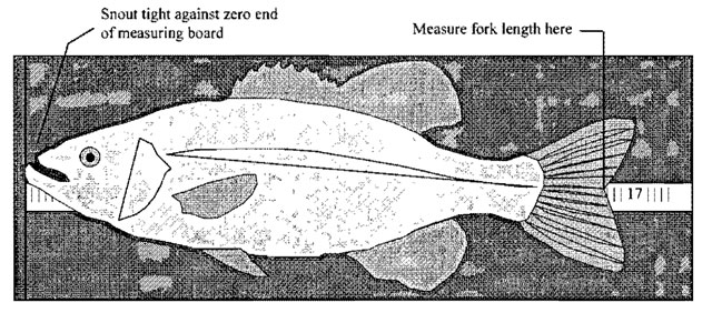
- Keeping the fish snug against the end and flat across the ruler, measure the fork length to the nearest 10 millimeter (1 centimeter) size class. Call out the size class to the data recorder as per the NSCIN Length Class Tally Form categories (e.g., a 312 mm fish would be called a 310 or a 31 - depending on the crew’s preference for conversing length classes in millimeters or centimeters).
- The data recorder must record that measurement by placing a tally dot in the appropriate size class under the appropriate species column (see section 6.7).
- If additional fish sampling is required by the project leader (e.g., weights, age tissue collections, etc.), then the fish handler proceeds to collect that additional information while the data recorder documents the data separately from the length class tallies (e.g., on scale envelopes).
- When all the required information has been collected, release the fish by gently tossing it back into the water on the offshore side of the boat. If fish are released on the nearshore side of the boat, they may remain around the gap and heart of the trap net and thus may be recaptured during the net removal procedure.
- Continue the length class sampling by species until the entire catch (i.e., all fish that were captured in the crib) has been processed.
Note: Sometimes, exceptionally large catches are encountered that require too much processing time. In these cases, after length classing a predetermined (by the project leader) minimum sample size (e.g., 300 fish per species per lift), the remainder of the catch for that species would be counted only. Therefore, the number length class tallied, plus the number counted only, are added together to calculate the total catch, for that species, from that particular net set. - Once all the fish have been processed, the fish handler resumes net handling by closing the zipper and re-sealing it (see section 6.4, steps 6 and 7). The data recorder totals the tally sheet(s) and transfers the totals to the Fish Cateh Summary section of the NSCJN Effort/Catch Form (see section 6.7).
6.7 Recording fish data
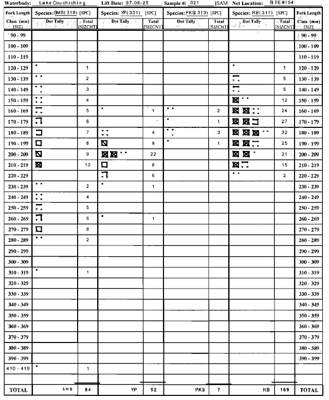
Fish catch information is recorded with an hb pencil, while processing the catch, on NSCIN Length Class Tally Forms (see Figure 9). After sampling the entire catch (i.e., all fish that were captured in the crib) of a particular net set, a catch summary is completed on the NSCIN Effort/Catch Form (see Figure 10). The following is a description of each of these forms:
NSCIN Length Class Tally Forms
There are two Length Class Tally Forms to cover the wide range offish sizes: One for small fish (less than 400 millimeters fork length) and one for large fish (greater than 399 millimeters fork length). There are also blank size class rows on each tally form to enable the crew to assign unique size classes if/when exceptionally small or large fish are encountered. Each tally form has four species columns. Therefore, if more than four species are captured, more than one tally form will be required. The NSCIN Length Class Tally Forms should be completed as follows:
Waterbody
Record the official name of the waterbody in which the trap net was set (e.g., Lake Couchichjng). This field must correspond to the NSCIN Effort/Catch Form.
Lift Date
Record numerically the date that the trap net was lifted, in the order year, month, day (i.e., August 25, 1997 would be recorded as 97-08-25). This field must correspond to the NSCIN Effort/Catch Form
Sample # [SAM]
Record the unique and sequential fishing effort number that refers to the particular net set (i.e., the first set of the project would be Sample # 001, and the next set would be Sample # 002). This field must correspond to the NSCIN Effort/Catch Form
Net Location
Record the shoreline segment number or UTM reference number used to identify the specific geographic location of the netting site (e.g., Site #154 or Grid #0802-Site #Cl3). This field must correspond to the information recorded on the NSCIN Effort/Catch Form.
Species [SPC]
Record the appropriate heading to identify the fish species tallied in that column. This field is relatively short as it is designed to record a fish acronym or number code (e.g., SMB or 316 for smallmouth bass). Some crews prefer to use their own series of distinguishable acronyms for recording fish species in the field, as fish number codes can be difficult to remember and easily confused. If acronyms are used in the field, they must be converted into OMNR fish species numbers at, or before, the Fishnet2 data entry process. See Appendix A for a complete list of OMNR fish species codes.
Dot Tally
Use this space to record a dot tally on the appropriate size class rows. Use the “box ten” method (i.e., four dots in a square, then four lines to connect the dots, then two lines crossed in the middle of the box to form an X).
Total [SIZCNT]
Record the sum for each species size class row (i.e., count the dot tally and record the total number offish measured, in each size class, for each species).
Use the bottom row of this column to record the total number of fish, of each particular species, that were length class tallied (i.e., combine all size classes per species). Each species total is copied to the Length Tallied column on the Fish Catch Summary section ofthe NSCIN Effort/Catch Form.
Note: Only fish that were captured by passing through the tunnel and into the crib can be considered part ofthe catch. Other improperly caught fish (e.g., trapped in hearts, gilled in leader, etc.) should be recorded as a comment only.
Figure 9: A completed NSCIN length class tally form for small fish (< 400 mm)
NSCIN Effort/Catch Form
The first part of the NSCIN Effort/Catch Form is filled out at the time of set on the previous day. Therefore, the same form is required in the field to complete the lift data and fish catch summary sections. The NSCIN Length Class Tally Forms that are completed to record fish data at a specific net set should correspond and be attached to the NSCIN Effort/Catch Form for that lift. The Fish Catch Summary section of the NSCIN Effort/Catch Form should be completed as follows:
Fish Catch Summary
These 5 fields summarize the catch by fish species.
Species [SPC]
Record the appropriate heading to identify the fish species represented in that row. This field is relatively short as it is designed to record a fish acronym or number code (e.g., SMB or 316 for small mouth bass). Some crews prefer to use their own series of distinguishable acronyms for recording fish species in the field, as fish number codes can be difficult to remember and easily confused. If acronyms are used in the field, they must be converted into OMNR fish species numbers at, or before, the Fishnet2 data entry process. See Appendix A for a complete list of OMNR fish species codes.
Counted Only
Record the total number of fish per species that were counted only (i.e., these fish are not included in the Length Tallied column).
Length Tallied
Record the total number offish per species that were length tallied as per the totals on the NSCIN Length Class Tally Form.
Total Catch [CATCNT]
Record the total number offish per species that were captured in the crib of the trap net (i.e., the sum of the Counted Only and Length Tallied columns for that species).
Biosampled [BIOCNT]
This is an optional column used to record the number offish per species that were sampled for additional biological information (i.e., the total number offish per species that had weights and/or scales, etc. collected).
Comments
This field is again used to document any useful descriptions or information.
Crews should provide any more information that may help to explain the uniqueness of the catch. (e.g., 3 SMB released from TN heart were not included in the total catch).
Figure 10: A completed NSCIN effort/catch form
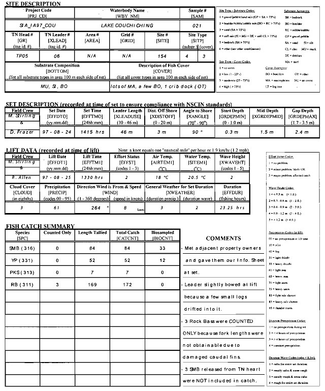
6.8 Moving Or Removing The Net
- To remove the spring-haul trap net for use at another site, lift one wing buoy and its marker line and retrieve the anchor from the lake bottom. Remove the anchor from the wing line. Cast the wing line back into the water. While traveling to the next wing, separate the recently retrieved marker buoy from its marker line, neatly wrap the marker line around the tines of the anchor, and safely place the anchor and buoy out of your way (some prefer to hang the anchors on the inside of the gunwale). Repeat this step for the other wing.
- Retrieve the king anchor by lifting its marker line and pull the boat towards the net along the king line. The king anchor and marker buoy can remain attached if you are simply moving to another site to reset the net. Lay the king line and brail lines neatly on the floor of the boat while you pull the boat up parallel to the brails.
Note:If you are removing the net for transportation to another lake or back to the office, remove the king anchor and marker buoy, and safely store the gear out of your way. - With a person at each end of the brails, grasp the metal brail in one hand, the wooden brail in the other hand, and pull the brails into the center of the boat. Spread the brails about 1 meter apart (3 ft.) to provide a platform to lay the rest of the net on.
Note:If removing the net for transportation, a tighter bundle can be created by flipping the brail formed platform over twice to retain the “wood to shore” arrangement. Keep the brails 1 meter apart (3 ft.) while flipping. This wraps the mesh of the crib around the brails and creates a more sturdy platform. - Neatly place the king line and brails lines on top of the mesh platform.
- Grasping the net’s side lines (float and lead lines along each side of the net), quickly pull the net into the boat and continue piling it on the platform created between the two brails. A fast net retrieval will reduce the amount of drifting caused by the wind and thus reduce the probability of net tangles and snags. In extremely windy and wavy conditions, the leader anchor can be removed first while the boat is being controlled by the field crew. This allows the crew to retrieve and pile the net without having to get too close to shore. Following the side lines, you should retrieve the net working your way along the outside of the crib, house, heart, and wings.
Note: A few fish may be trapped in the hearts and should be shaken back down the heart to the gap where you can reach in and pull the fish out. These fish are not part of the catch as they did not find their way into the crib via the tunnel. Be careful not to lift the heart too high when shaking fish towards the gap. There is a chance that you could shake fish down into the tunnel and eventually into the crib. The crib is buried under the piled net and sealed shut, .making the removal of these fish very difficult. - Continue retrieving the wings, placing each wing separately on each side of the pile, so that you will not be confused about which wing belongs to which side of the net when resetting. Similarly, continue retrieving the wing lines and place them on top of their respective wing.
- With one person pulling on the float line and the other person pulling on the lead line, retrieve the leader folding it neatly back and forth on top of the net pile. Be sure not to allow a twist to occur in the leader at this point.
- Lastly, pull in the leader anchor and safely place it on the floor or over the inside of the gunwale. This anchor can usually remain attached for the next set.
Note: If removing the trap net for transportation to another lake or back to the office, untie the leader anchor and place it safely out of your way. A tight carrying bundle can be created by laying the last meter (3 ft.) of leader over the net pile, like a “hair net”, and tucking the sides and ends in under the mesh piled on the platform. This helps to keep pieces of the net from falling out of the bundle.
Note: Next, use a reasonable length of rope (leader anchor line works well) to wrap around the bundle. Starting at one end, wrap the rope around the bundle and link each subsequent wrap with one tum around the previous wrap. Use a wrap about every 30 to 40 cm (12 to 16 in.) along the length of the bundle. Pull each wrap tight to make the bundle as small and compact as possible. One person can help to steady the net and provide enough room to get the rope around the bundle by lifting one end at the brails. Wrap any extra rope around the ends of the bundle where most of the weights or floats are packed.
7.0 Post-field activities
The following activities should be conducted within a couple days of completing the field portion of the NSCIN program.
7.1 Net storage
Trap nets must be thoroughly dried before being transported to another waterbody to prevent transporting any exotic plant or animal species (e.g., Eurasian watermilfoil, spiny water flea, zebra mussel, etc.). If the trap nets are clean at the end of the field work, they can be dried by being blocked up in a warm storage room. Make sure that each net is exposed to the air all the way around the bundle, and that any water running off will drain away from the net. Ensure that your storage room is sealed to prevent mice or squirrels from getting to the nets. These nuisance animals tend to damage the nets by chewing on the netting materials, and will often build nests and over-winter in the net bundles.
If a net has weeds or algae clinging to it, the net should be unpacked and cleaned by pressure spraying and/or hanging on a drying rack. If quickly dried, algae will break down and fall off the net. If drying outside, do not expose the net to the sunlight for a long period of time, as the sun will deteriorate the netting materials. Do not leave a dirty net tightly bundled. The plants and algae will hold moisture in the bundle and cause the net to rot. Polypropylene nets are more resistant to rotting than other traditional materials and will last much longer if properly maintained and stored in a building where they are protected from sunlight, moisture, and nuisance animals.
The trap nets must be carefully inspected during the off season for rips and tears. This inspection should be completed at the beginning of the storage period to provide ample time to conduct, or budget for, the appropriate repairs. Watch for areas where the mesh has separated from the lead line (bottom of net) as a result of damaged lashing. When feasible, major repairs should be done by the manufacturer to ensure that the correct techniques and materials are used.
7.2 Gear log
Trap net inspections, repairs, and field seasons, should be recorded in a trap net gear log to document the net’s status and history. Since these nets are often stored for long periods of time and/or loaned to other users, it is very useful and informative to keep track of what happens to each net. In this way, project leaders are less likely to be surprised with costly repair expenses, scheduling conflicts, or biased fishing results that can arise from being unaware of a net’s status.
8.0 Data management
The information recorded on the NSCJN forms are in a format compatible with the software package Fishnet2- provided by the Ontario Fisheries Information System (OFIS). Therefore, data entry can be done directly from the NSCJN forms. A copy of the Fishnet2 NSCIN Project Template (a modified Index Adult template), and data entry assistance, can be obtained from the Lake Simcoe Fisheries Assessment Unit (LSFAU)- see section 9.0 (Project Assistance) for their address and telephone number.
Completed projects should be copied onto computer diskettes and forwarded to the LSFAU for submission in the provincial NSCIN database (see section 9.0). The LSFAU will ensure that copies of completed projects are forwarded to OFIS annually for submission in the fishnet data archive called fisharc.
9.0 Project assistance
Please contact the LSFAU (address below) for assistance in any of the following areas:
- Information on borrowing NSCIN standard trap nets.
- Copies of the Fishnet2 NSCIN Project Template (modified Index Adult template).
- Fishnet2 data entry procedures for NSCIN
- Submission of completed projects to the provincial NSCIN database.
- Copies of the standard NSCIN forms (in colour if preferred- computer file available).
- Any other NSCIN inquiries.
Ontario Ministry Of Natural Resources Lake Simcoe Fisheries Assessment Unit R.R. #2, Park Road
Sutton West, Ontario
L0E JR0
Telephone (905) 722-5512
Fax (905) 722-3797
Acknowledgements
The original NSCIN design evolved thanks to the commitment of all program participants. Development of the NSCIN program from 1991 to 1997 was a cooperative effort involving OMNR staff from FAUs, Fisheries Research, OFIS, and District Offices.
Sample Size recommendations and other NSCJN results were previously reported in the FAU Network Report 1997-1 entitled “Nearshore Community Index Netting (NSCIN) in Ontario: Year 5 Update” (Willox et al. 1997).
Some information on the background of the NSCIN program was taken from the Lake Simcoe FAU Internal Report 1992-10 entitled “Near-Shore Community Index Netting On FAU Lakes: A Proposal For Standardizing Methodologies” (Willox 1992).
The Standard NSCIN Trap Net Description was previously reported in a FAU Network Update entitled "FAU Network Recommends Trap Net Standard for NSCIN quot; (Allen and Willox 1998).
Portions of the Gear Description and Field Procedures were adapted from previous FAU manuals (Allen 1992, Fulford 1993, and MacKay 1996). Many of the classifications and data coding conventions were adapted from standards reported in the OMNR fishnet User Manual (Lester et al. 1996) and the OMNR Manual Of Instructions for Aquatic Habitat Inventory Surveys OMNR 1987).
Special thanks go to the following list of individuals who provided constructive reviews of earlier drafts of this manual: Ron Allen, Chuck Brady, Mike Fruetel, Frank Hicks, Peter Hulsman, Brian Jackson, Butch (Wayne) LaFrance, Mike Powell, Henk Rietveld, and Cam Willox.
Bibliography
Allen, R.J. 1992. Lake Simcoe Nearshore Community Index Netting Manual. Ontario Ministry Of Natural Resources. Lake Simcoe Fisheries Assessment Unit File Report 1992-14. 20p.
Allen, R., and C. Willox. 1997. FAU Network Recommends Trap Net Standard for NSCIN Ontario Ministry Of Natural Resources. Fisheries Assessment Unit Network Update. 6p.
Fulford, P.J. 1993. Nearshore Community Index Netting (NSCIN): 1993 Sampling Methods. Ontario Ministry Of Natural Resources. Lake Simcoe Fisheries Assessment Unit Report 1993-1. 13p.
Hubert, W.A. 1996. Passive Capture Techniques. Pages 157-192 in B.R. Murphy and D.W. Willis, editors. Fisheries Techniques, 2nd Edition. American Fisheries Society, Bethesda, Maryland.
Lester, N.P., P. Chen, M.E. Daniels, C. Deary, R. Korver, R. Kushneriuk, and F. McNeil. 1996. Ontario Fisheries Information System: fishnet User Manual. Ontario Ministry of Natural Resources.
Lester, N.P., W .I. Dunlop and C.C. Willox. 1996. Detecting Changes In The Nearshore Fish Community. Pages 391-402 in Canadian Journal of Fisheries and Aquatic Sciences Volume 53 Supplement I. National Research Council of Canada
MacKay, L. 1996. Field Manual: Near Shore Community Index Netting Program 1996. Ontario Ministry Of Natural Resources. Muskoka Lakes Fisheries Assessment Unit File Report 1996-5. 27p.
Monroe, B. 1997. The Role Of Mesh Size In The Size Distribution Of Fish Caught In 5-Foot And 6-Foot Trapnets. Ontario Ministry Of Natural Resources. Algonquin Fisheries Assessment Unit Report. 12p.
Ontario Ministry of Natural Resources. 1987. Aquatic Habitat Inventory Surveys: Manual oflnstructions. Queens Printers for Ontario. 248 p.
Willox, C. 1992. Near-Shore Community Index Netting On FAU Lakes: A Proposal For Standardizing Methodologies. Ontario Ministry Of Natural Resources. Lake Simcoe Fisheries Assessment Unit Internal Report 1992-10. 13p.
Willox, C.C., M. Fruetel, and N.P. Lester. 1997. Nearshore Community Index Netting (NSCIN) in Ontario: Year 5 Update. Ontario Ministry of Natural Resources. Fisheries Assessment Unit Network Report 1997-1: 29p.
Willox, C.C. and N.P. Lester. 1994. Development Of Netting Standards for Ontario Lakes. Ontario Ministry Of Natural Resources. Fisheries Assessment Unit Network Report 1994-1. 10p.
Appendix A: Master list of species codes and common names of Ontario fish (May 1998)
010. Petromyzontidae - lampreys
- 011. American brook lamprey - Lampetra appendix
- 012. northern brook lamprey - lchthyomyzon fossor
- 013. silver lamprey - Ichthyomyzon unicuspis
- 014. sea lamprey - Petromyzon marlnus
- 015. lchthyomyzon sp.
- 016. chestnut lamprey - lcthyomyzon castaneus
020. Polyodontidae - Paddlefishes
- 021. paddlefish - Polyodon spathula
030. Acipenseridae - Sturgeons
- 031. lake sturgeon - Acipenser fufvescens
- 032. caviar
040. Lepisosteidae - Gars
- 041. longnose gar - Lepisosteus osseus
- 042. spotted gar - Lepisosteus ocutatus
- 043. Lepisosteus sp.
050. Amiidae - Bowfins
- 051. bowfin - Amia calva
060. Clupeidae - Herrings
- 061. alewife - Alosa pseudoharengus
- 062. American shad - Alosa sapidissima
- 063. Gizzard shad - Dorosoma cepedianum
- 064. Alosa sp.
Salmonidae -Trouts:
070. Salmoninae - Salmon and Trout subfamily
- 071. pink salmon - Oncorhynchus gorbuscha
- 072. chum salmon - Oncorhynchus keta
- 073. coho salmon - Oncorhynchus kisutch
- 074. sockeye salmon - Oncorhynchus narka
- 075. chinook salmon - Oncorhynchus tshawytscha
- 076. rainbow trout - Oncorhynchus mykiss
- 077. Atlantic salmon - Salmo salar
- 078. brown trout - Salmo trutta
- 079. Arctic char - Safvelinus alpinus
080. brook trout - Safvelinus fontinalis
- 081. lake trout - Salvelinus namaycush
- 082. splake - Salvelinus fontinalis x Salvelinus namaycush
- 083. Aurora trout - Salvelinus fontinalis timagamiensis
- 084. Oncorhynchus sp.
- 085. Salmo sp.
- 086. Salvelinus sp.
090. Coregoninae - Whitefish subfamily
- 091. lake whitefish - Coregonus clupeaformis
- 092. longjaw cisco - Coregonus alpenae
- 093. cisco (lake herring) - Coregonus artedi
- 094. bloater - Coregonus hoyi
- 095. deepwater cisco - Coregonus johannae
- 096. kiyi - Coregonus kiyi
- 097. blackfin cisco - Coregonus nigripinnis
- 098. Nipigon cisco - Coregonus nipigon
- 099. shortnose cisco - Coregonus reighardi
- 100. shortjaw cisco - Coregonus zenithicus
- 101. pygmy whitefish - Prosapium caulteri
- 102. round whitefish - Prasapium cylindraceum
- 103. chub - Careganus sp.(Cisco species other than C. artedi)
- 106. Careganus sp.
- 107. Prosapium sp.
110. Thymallinae - Grayling subfamily
- 111. Arctic grayling - Thymallus arcticus
120. Osmeridae - Smetts
- 121. rainbow smelt - Osmerus mordax
130. Esocidae - Pikes
- 131. northern pike - Esox lucius
- 132. muskellunge - Esox masquinongy
- 133. grass pickerel - Esox americanus vermiculatus
- 134. Esox sp.
- 135. chain pickerel - Esax niger
140. Umbridae - Mudminnows
- 141. central mudminnow - Umbra limi
150. Hiodontidae - Mooneyes
- 151. goldeye - Hiodon alosoides
- 152. mooneye - Hiodon tergisus
160. Catostomidae - Suckers
- 161. quillback - Carpiades cyprinus
- 162. longnose sucker - Catostomus catostomus
- 163. white sucker - Catostomus commersoni
- 164. lake chubsucker - Erimyzon sucetta
- 165. northern hog sucker - Hypentelium nigricans
- 166. bigmouth buffalo - Ictiobus cyprinellus
- 167. spotted sucker - Minytrema melanops
- 168. silver redhorse - Moxostoma anisurum
- 169. black redhorse - Moxostoma duquesnei
- 170. golden redhorse - Moxostoma erythrurum
- 171. shorthead redhorse - Moxostoma macrolepidotum
- 172. greater redhorse - Moxostoma valenciennesi
- 173. river redhorse - Moxostoma carinatum
- 174. black buffalo - Ictiobus niger
- 176. Catostomus sp.
- 177. Moxostoma sp.
- 178. Ictiobus sp.
180. Cyprinidae - Carps and Minnows
- 181. goldfish - Carassius auratus
- 182. northern redbelly dace - Phoxinus eos
- 183. finescale dace - Phoxinus neogaeus
- 184. redside dace - Clinostomus elongatus
- 185. lake chub - Couesius plumbeus
- 186. common carp - Cyprinus carpio
- 187. gravel chub - Erimystax x-punctatus
- 188. cutlips minnow - Exoglossum maxillingua
- 189. brassy minnow - Hybognathus hankinsoni
- 190. eastern silvery minnow - Hybognathus regius
- 191. silver chub - Macrhybopsis storeriana
- 192. hornyhead chub - Nocomis biguttatus
- 193. river chub - Nocomis micropogon
- 194. golden shiner - Notemigonus crysoleucas
- 195. pugnose shiner - Notropis anogenus
- 196. emerald shiner - Notropis atherinoides
- 197. bridle shiner - Notropis bifrenatus
- 198. common shiner - Luxilus cornutus
- 199. blackchin shiner - Notropis heterodon
- 200. blacknose shiner . Notropis heterolepis
- 201. spottail shiner - Notropis hudsonius
- 202. rosyface shiner - Notropis rubellus
- 203. spotfin shiner - Cyprinella spiloptera
- 204. sand shiner - Notropis stramineus
- 205. redfin shiner - Lythrurus umbratilis
- 206. mimic shiner - Notropis volucellus
- 207. pugnose minnow - Opsopoeodus emiliae
- 208. bluntnose minnow - Pimephales notatus
- 209. fathead minnow - Pimephales promelas
- 210. blacknose dace - Rhinichthys atratulus
- 211. longnose dace - Rhinichthys cataractae
- 212. creek chub - Semotilus atromaculatus
- 213. fallfish - Semotilus corporalis
- 214. pearl dace - Margariscus margarita
- 215. silver shiner - Notropis photogenis
- 216. central stoneroller - Campostoma anomalum
- 217. striped shiner - Luxilus chrysocephalus
- 218. ghost shiner - Notropis buchanani
- 219. grass carp - Ctenopharyngodon idella
- 220. rudd - Scardinius erythrophthalmus
- 221. Phoxinus sp.
- 222. Hybognathus sp.
- 223. Nocomis sp.
- 224. Notropis sp.
- 225. Pimephales sp.
- 226. Rhinichthys sp.
- 227. Semotilus sp.
- 228. Hybopsis sp.
- 229. Luxilus sp.
230. Ictaluridae - Bullhead Catfishes
- 231. black bullhead - Ameiurus melas
- 232. yellow bullhead - Ameiurus natalis
- 233. brown bullhead - Ameiurus nebulosus
- 234. channel catfish - lctalurus punctatus
- 235. stonecat - Noturus flavus
- 236. tadpole madtom - Noturus gyrinus
- 237. brindled madtom - Noturus miurus
- 238. margined madtom - Noturus insignis
- 239. flathead catfish - Pylodictis olivaris
- 241. lctalurus sp.
- 242. Noturus sp.
- 243. Ameiurus sp.
- 244. northern madtom - Noturus stigmosus
250. Anguillidae - Freshwater Eels
- 251. American eel - Anguilla rostrata
260. Cyprinodontidae - Killifishes
- 261. banded killifish - Fundulus diaphanus
- 262. blackstripe topminnow - Fundulus notatus
270. Gadidae - Cads
- 271. burbot - Lota lota
280. Gasterosteidae - Sticklebacks
- 281. brook stickleback - Culaea inconstans
- 282. threespine stickleback -.Gasterosteus aculeatus
- 283. ninespine stickleback - Pungitius pungitius
- 284. fourspine stickleback - Apeltes quadracus
290. Percopsidae - Trout-perches
- 291 trout-perch - Percopsis omiscomaycus
300. Percichthyidae - Temperate Basses
- 301. white perch - Marone americana
- 302. white bass - Marone chrysops
- 303. Marone sp.
310. Centrarchidae - Sunfishes
- 311. rock bass - Ambloplites rupestris
- 312. green sunfish - Lepomis cyanellus
- 313. pumpkinseed - Lepomis gibbosus
- 314. blue gill - Lepomis macrochirus
- 315. longear sunfish - Lepomis megalotis
- 316. smallmouth bass - Micropterus dolomieu
- 317. largemouth bass - Micropterus salmoides
- 318. white crappie - Pomoxis annularis
- 319. black crappie - Pomoxis nigromaculatus
- 320. Lepomis sp.
- 321. Microplerus sp.
- 322. Pomoxis sp.
- 323. wannouth - Lepomis gulosus
- 324. orangespotted sunfish - Lepomis humilis
330. Percidae - Perches
- 331. yellow perch - Perea flavescens
- 332. sauger - Stizostedion canadense
- 333. blue pike (blue pickerel) - Stizostedion vitreum glaucum
- 334. walleye (yellow pickerel) - Stizostedion vitreum
- 335. eastern sand darter - Ammocrypla pellucida
- 336. greenside darter - Etheostoma blennioides
- 337. rainbow darter - Etheostoma caeruleum
- 338. Iowa darter - Etheostoma exile
- 339. fantail darter - Etheostoma flabellare
- 340. least darter - Etheostoma microperca
- 341. johnny darter - Etheostoma nigrum
- 342. logperch - Percina caprodes
- 343. channel darter - Percina copelandi
- 344. blackside darter - Percina maculata
- 345. river darter - Percina shumardi
- 346. tessellated darter - Etheostoma olmstedi
- 347. Stizostedion sp.
- 348. Etheostoma sp.
- 349. Percina sp.
- 350. ruffe - Gymnocephalus cemuus
360. Atherinidae - Silversides
- 361. brook silverside - Labidesthes sicculus
365. Gobiidae - Gobies
- 366. round goby - Neogobius melanostomus
- 367. tubenose goby - Proterorhinus marmoratus
370. Sciaenidae - Drums
- 371. freshwater drum - Aplodinotus grunniens
380. Cottidae - Sculpins
- 381. mottled sculpin - Cottus bairdi
- 382. slimy sculpin - Cottus cognatus
- 383. spoonhead sculpin - Cottus ricei
- 384. deepwater sculpin - Myoxocephalus thompsoni
- 385. Cottus sp.
- 386. Myoxocephalus sp.
- 387. fourhorn sculpin - Myoxocephalus quadricomis
390. Cyclopteridae - Lumpfishes
- 391. lumpfish - Cyclopterus lumpus
395. Pleuronectidae - Righteye Flounders
- 396. European Flounder - Platichthys flesus
400. Salmonidae - Hybrids
420. Salmoninae - Hybrids
450. Coregoninae - Hybrids
500. Esocidae - Hybrids
- 501. Esox lucius x Esox americanus vermiculatus
- 502. Esox lucius x Esox masquinongy
550. Catostomidae - Hybrids
- 551. Icliobus hybrids
600. Cyprinidae - Hybrids
- 601. Carassius auratus x Cyprinus carpio
- 602. Phoxinus hybrids
- 603. Phoxinus eos x Phoxinus neogaeus
- 604. Phoxinus eos x Margariscus margarita
- 605. Phoxinus neogaeus x Margariscus margarita
- 610. Notropis hybrids
- 611. Luxilus comutus x Notropis rubellus
- 612. Luxilus comutus x Semotilus atromaculatus
- 620. Pimephales promelas x Pimephales notatus
650. Ictaluridae - Hybrids
- 651. Ameiurus melas x Ameiurus nebulosus
700. Centrarchidae - Hybrids
- 701. Lepomis hybrids
- 702. Lepomis gibbosus x Lepomis macrochirus
- 703. Lepomis cyanellus x Lepomis gibbosus
- 704. Lepomis cyanellus x Lepomis megalotis
- 705. Lepomis cyanelfus x Lepomis macrochirus
- 706. Pomoxis annularis x Pomoxis nigromaculatus
750. Percidae - Hybrids
- 751. Stizostedion canadense x Stizostedion vitreum
800. Cottidae - Hybrids
- 801. Cottus bairdi x Cottus cognatus
Appendix B: NSCIN Forms
The following blank copies of the NSCIN forms are required to record the results from your NSCIN program. To facilitate direct photocopying for field use, the forms are full size and intentionally not labeled with the instruction manual page numbers. Save these forms as master copies for use in future NSCIN field programs.
- NSCIN Trap Net Description - Form 1
- NSCIN Trap Net Description - Form 2
- NSCIN Effort/Catch Form
- NSCIN Length Class Tally Form - Small Fish (< 400 mm)
- NSCIN Length Class Tally Form - Large Fish (> 399 mm)
Electronic computer copies of the NSCIN forms are available for re-printing purposes (see sections 5.4 and 9.0). Photocopied or laser printed versions are often more field worthy than versions made with ink printers. Ink printed versions tend to smear and the ink will run if the forms get wet The toner used in photocopiers and laser printers tends to hold up very well to water damage.