Northern McConkey Conservation Reserve Management Statement
This document provides policy direction for the protection, development and management of the Northern McConkey Conservation Reserve and its resources.
Northern McConkey Conservation Reserve (C121)
Statement of Conservation Interest
Ministry of Natural Resources
Parry Sound District
Prepared with the assistance of:
Meteek & Company
Huntsville, Ontario
March, 2003
Approval statement
We are pleased to approve this Statement of Conservation Interest for Northern McConkey Conservation Reserve (C121).
Northern McConkey Conservation Reserve is a 1,245 hectare area of Crown land, lying in the unincorporated area of McConkey Township in the Territorial District of Parry Sound. It is located about 70 kilometres southwest of North Bay and about 70 kilometres northeast of the Town of Parry Sound. The conservation reserve is bordered on the south by Wolf River and Dollars Lake and on the north by Blaney Creek.
This site contains about two dozen different combinations of vegetation and landforms representative of Hill’s ecological Site District 5E -5. These include hilly bedrock uplands with treed wetlands and stands of poplar, white birch, sugar maple and white pine. There are also less hilly stretches of bedrock with meadows, alder swales, treed wetlands, and stands of white birch, red maple and white cedar. The site contains portions of two deer yards, and offers suitable habitat for several wildlife species typical of the area.
The conservation reserve and surrounding area are used for a variety of traditional activities, including hunting, fishing, fur harvesting, canoeing and boating.
Much of Northern McConkey Conservation Reserve is adjacent to a pre-existing Restricted Access Area of the Parry Sound District.
Northern McConkey Conservation Reserve is one of 378 new protected areas approved through Ontario’s Living Legacy Land Use Strategy, aimed, in part, at completing Ontario’s system of parks and protected areas.
During the "Lands for Life" planning process, the public was widely consulted and provided valuable input into what became Ontario’s Living Legacy Land Use Strategy. During consultation related to the formal Public Lands Act (Ontario Regulation 805/94) regulation of the boundaries of this conservation reserve (in 2000 and 2001), a number of minor boundary changes were made to ensure the boundaries reflected areas requiring protection. Comments received during public consultation were generally supportive of the protection of this area. Stakeholders who provided comment during the earlier consultation for this site were subsequently consulted regarding the draft Statement of Conservation Interest and their comments were considered in the finalization of this document.
This Statement of Conservation Interest provides guidance for the management of the conservation reserve and provides the basis for the ongoing monitoring of activities. More detailed direction is not anticipated at this time. Should more complex resource management or conservation issues arise or significant facility development be considered, then a detailed Resource Management Plan will be prepared with full public consultation.
Northern McConkey Conservation Reserve is managed under the direction of the District Manager and the Parry Sound Area Supervisor of the Ministry of Natural Resources, Parry Sound District.
Approved by:
R. Griffiths
District Manager
Parry Sound District
Approved by:
Ron Running
Regional Director
Southcentral Region
Figure 1: Location of Northern McConkey Conservation Reserve
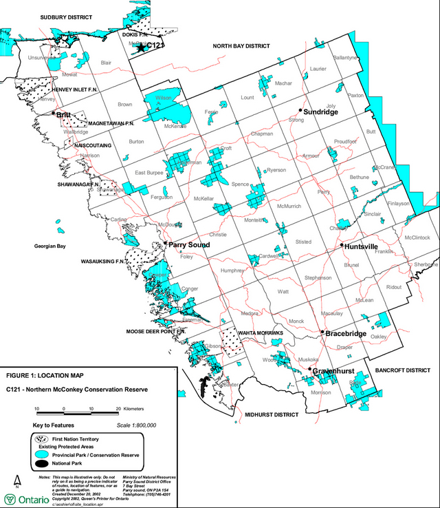
Enlarge Figure 1: Location of Northern McConkey Conservation Reserve
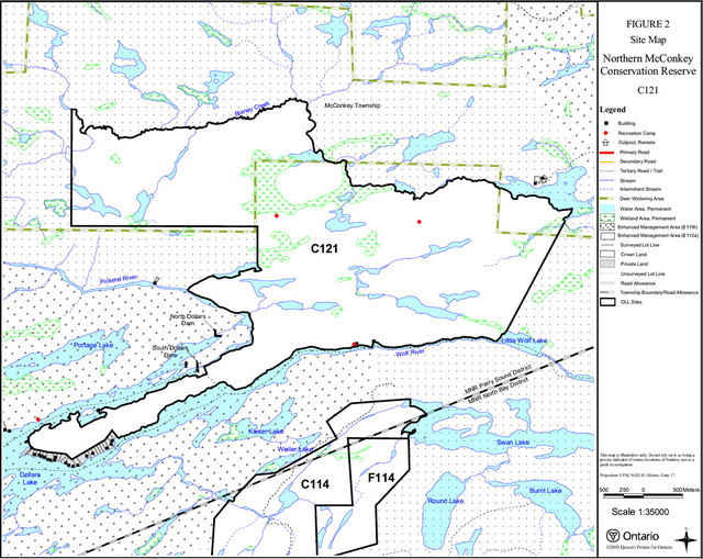
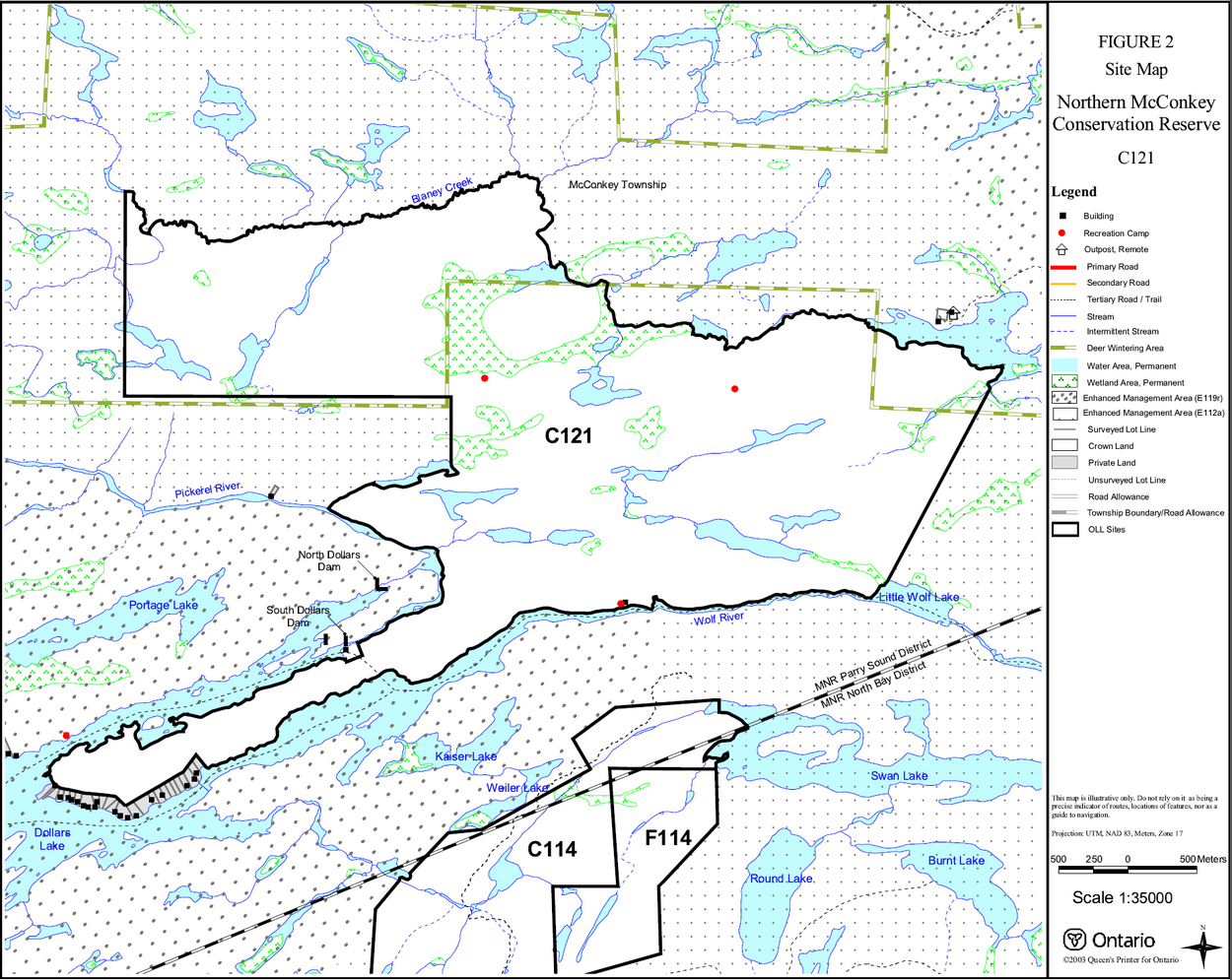
Figure 2: Site Map – Northern McConkey Conservation Reserve (C121)
Enlarge Figure 2: Site Map – Northern McConkey Conservation Reserve (C121)
1.0 Introduction
Ontario’s Living Legacy, the result of an extensive planning process that began in early 1997, culminated in the approval in July 1999 of a Land Use Strategy that identifies the intended strategic direction for Crown land, including the completion of Ontario’s system of parks and protected areas. This process, which included extensive public consultation, resulted in the recommendation for regulation of 378 new protected areas, including Northern McConkey Conservation Reserve (C121).
Northern McConkey Conservation Reserve is located in the unincorporated area of McConkey Township in the Territorial District of Parry Sound. It lies roughly equidistant between Provincial Highway 11 to the east and 69 to the west, and about 8 kilometres northeast (by water) from Ess Narrows on Highway 522. There are no roads that provide access to this conservation reserve, and most of the site is adjacent to the North Pickerel River Enhanced Management Area - Remote Access (E112a) (OMNR 1999), which was formerly a Restricted Access Area in the Parry Sound District Land Use Guidelines (OMNR 1983). The policies that applied to Restricted Access Areas, primarily prohibiting new public access roads and new trails, will continue to apply to the adjacent E112a, as well as this conservation reserve. The lands immediately west of this site are within the North Parry Sound Enhanced Management Area - Recreation (E119r), which is a multiple use area intended to be managed for its high quality recreation, forest management, wildlife management and tourism values.
Northern McConkey Conservation Reserve encompasses a large area that contains diverse botanical and wildlife habitats within Hill’s ecological Site District 5E -5. It contains a landscape of low-relief bedrock uplands interspersed with small lakes, ponds and wetlands. The area has a history of logging and forest fires, (including an old (circa 1920s) mill site). The resultant forests have been influenced by this past activity. The conservation reserve also contains parts of the Portage Lake and Etta Lake deer yards although there is no evidence of deer wintering there within the last 20 years.
Although there is no road access close to this conservation reserve, there are many trails and the area is used extensively by snowmobiles and all-terrain vehicles. This use is apparently in conjunction with hunting and fishing in the area, and with the use of a number of cottages located at the western end of the peninsula between the Wolf and Pickerel Rivers at Dollars Lake.
The Wolf River and Pickerel River are part of a traditional canoe route.
Conservation reserves are established under the authority of the Public Lands Act, Ontario Regulation 805/94. The Northern McConkey Conservation Reserve was established by Ontario Regulation 148/02, an amendment of the Public Lands Act, on May 8, 2002.
A Statement of Conservation Interest (SCI) is prepared under the authority of Procedural Guideline A – Resource Management Planning (PL. Procedure 3.03.05). The purpose of this SCI is to identify and describe the values of Northern McConkey Conservation Reserve. The SCI also outlines the activities that currently occur within the conservation reserve and provides guidelines for the management of current and future activities in the context of protecting the natural, recreational and cultural values.
1.1 Background information:
| Name | Northern McConkey Conservation Reserve (C121) |
|---|---|
| Site Region/District | 5E-5 |
| OMNR Administrative Region/District/Area | Southcentral Region/Parry Sound District/ Parry Sound Area |
| Total Area (ha.) | 1,245 hectares |
| Regulation Date | May 8, 2002 (O. Reg. 148/02) |
| First Nations | Robinson-Huron Treaty |
| OBM map sheets | 20 17 5600 50800, 20 17 5600 50900 |
| Topographic Map | Noganosh 41H/16 |
| UTM co-ordinates | 17T 56770 509210 (Centroid) |
1.2 Representation:
Earth science representation:
Bedrock - Paragneiss of the Britt Domain, Algonquin Terrane, in the Central Gneiss Belt of the Proterozoic Grenville Province.
Surficial - The surficial topography has been heavily influenced by glacial scouring, followed by erosion and reworking by the receding waters of post-glacial Lake Algonquin.
Life science representation:
A large remote area with a diversity of botanical and wildlife habitats, including:
- Intolerant hardwood forest dominated by white birch (Betula paperifera), red maple (Acer rubrum), white spruce (Picea glauca) and trembling aspen (Populus tremuloides)
- Large area of tolerant hardwood forest, including sugar maple (Acer saccharum), red maple, yellow birch (Betula alleghaniensis), black ash (Fraxinus nigra) and white spruce
- Coniferous forests on sands and tills over bedrock, with white pine (Pinus strobus), red pine (Pinus resinosa) and eastern hemlock (Tsuga canadensis), and including some sugar maple and yellow birch
- Graminoid/sedge marshes
Cultural resources representation:
Neither detailed cultural research nor inventory has been carried out for this conservation reserve. However, there is ample evidence of early logging activity (including an old mill site), probably ending by the 1940s. The proximity of the conservation reserve to the Pickerel and French Rivers suggests that this area may have a long history as part of traditional harvest areas and travel ways. Recent regional evaluation (OMNR 2003) shows that this conservation reserve contains areas that have a high potential for cultural heritage sites.
Recreational opportunities:
A recreational inventory report was prepared for this site, based primarily on existing knowledge and data sources of MNR staff, and reflecting field observations made during the preparation of the life science report. The area is recognized as providing many recreation opportunities. It is used for big and small game hunting, sport fishing, canoeing, snowmobiling, and all-terrain vehicle travel. Three recreation camps, authorized by MNR under the Public Lands Act, Ontario Regulation 805/94, are located within the conservation reserve, and approximately a dozen cottages are located adjacent to the site on the south -western part of the peninsula where Wolf River joins Dollars Lake. It is presumed that much of the use of the conservation reserve comes from these sources. The Wolf and Pickerel River are part of a traditional canoe route, so camping by canoeists may occur.
1.3 Survey work:
| Survey Level | Earth Science | Life Science | Cultural | Recreational | Other |
|---|---|---|---|---|---|
| Reconnaissance | Duba & Frey, 2000 | Blythe & Assoc., 2002 | OMNR 2003 | Brown, 2002 | None |
| Detailed | None | None | None | None | None |
| Requirement | None | Monitor the status/presence of significant species and associations. | Research to be encouraged. | Document current activity and monitor use impacts | None |
2.0 Values to be protected
The conservation reserve is located entirely within Hills' (1959) ecological Site District 5E -5. Values include earth science, life science and recreational/aesthetic values, with an emphasis on the life sciences.
2.1 Earth science:
(Earth science information, unless otherwise noted, is taken from Duba & Frey, 2000)
Bedrock:
The Northern McConkey Conservation Reserve is a low relief area of sparse hilltop bedrock outcrop. The dominant rock type is paragneiss of the Britt Domain, Algonquin Terrain, in the Central Gneiss Belt of the Proterozoic Grenville Province.
The Grenville Province is the product of thrusting and imbrication of the earth’s crust to the northwest as it collided with a continental land mass to the southeast. The Grenville Orogeny, circa 1140 to 1070 million years ago, culminated more than 500 million years of crustal evolution. The eroded roots of the products of these events are displayed in the complexly metamorphosed and deformed rocks of the region (Easton, 1992b).
The Algonquin Terrane is one of four lithotectonic terranes of the Central Gneiss Belt. Within the Algonquin Terrane, the Britt Domain is one of twelve structural domains. This geological environment is part of the modern organization of the complex products of the mid-Proterozoic Grenville orogenic events (Easton, 1992a & b). As such, its representation in Northern McConkey Conservation Reserve contributes to the conservation of the Grenville continental accretion theme outlined by Davidson (1981).
Within the Ontario Provincial Park system, the bedrock geological features observed in Northern McConkey Conservation Reserve have local significance in its representation of paragneiss typical of a large part of the Britt Domain.
Surficial:
The glacially deposited tills and deposits of silt and clay are typical components of the Late Wisconsinan Stage of the Quaternary Era in southwestern Ontario.
Organic deposits of drainages and wetlands underlie the low relief terrain between uplands.
2.2 Life science:
(Life science information, unless otherwise noted, is taken from Blythe & Associates, 2002)
In late May 1997, the Ministry of Natural Resources (Natural Heritage Information Centre and Natural Heritage Section) carried out a natural heritage "gap analysis" project for Site District 5E-7 and 5E-8, in conjunction with Ontario Living Legacy’s Land Use Planning. The purpose of the gap analysis was to identify different vegetation and landform combinations that were not included in protected areas at that time. Geographic Information Systems technology was used and applied to the following criteria: 1) representation of landform-vegetation patterns; 2) diversity; 3) condition; 4) ecological considerations; and 5) special features (Crins and Kor 1998). Northern McConkey Conservation Reserve was identified through this gap analysis.
Representation:
Northern McConkey Conservation Reserve encompasses a large area of remote forest habitat. Owing to its relatively large size of 1,245 hectares, the conservation reserve contains a diversity of landform and vegetation features.
The topography of this site features bedrock hills, areas of glacially deposited till, and deposits of silt and clay. The surficial topography has also been heavily influenced by glacial scouring, followed by erosion and reworking by the receding waters of post-glacial Lake Algonquin. These factors, in combination with logging activities of the late 19th to mid 20th centuries and the influence of one or more large post -logging forest fires, have created the present day conservation reserve environment with its variety of forest types.
The most extensive type of forest is the intolerant hardwood forest, which had its genesis in the history of logging and fires. It is dominated by large stands of white birch, red maple, white spruce and trembling aspen. The relatively open forest floor of these stands supports a large number of herbaceous species, including wild sarsaparilla (Aralia nudicaulis), long-awned wood grass (Brachyelytrum erectum), intermediate woodfern (Dryopteris intermedia), oak fern (Gymnocarpium dryopteris), assorted asters (Aster spp.) and Canada mayflower (Maianthemum canadensis).
Some large areas of tolerant hardwood forest usually associated with richer silt/clay soils are located north of Wolf River. The predominant species here include sugar maple, red maple, yellow birch, black ash and white spruce. The understory found in the forest is similar to that found in the intolerant hardwood portions of the conservation reserve.
There is also a significant component of coniferous forests found associated with higher elevations, deposits of sand and areas of shallow till over bedrock. These forests have a mixture of white pine, red pine, eastern hemlock, and to a lesser degree, sugar maple and yellow birch.
Throughout the area there are sporadic large specimens of older white pine and eastern hemlock, presumably left behind during earlier periods of timber harvest.
There are a few examples of graminoid/sedge meadows within the reserve. The dominant species in these wetlands are Canadian bluejoint grass (Calamagrostis canadensis), woolgrass (Scripus cyperinus) and nodding sedge (Carex gynandra).
Condition:
While there is ample evidence of early logging throughout the site, there has been no recent commercial timber harvesting in the conservation reserve and such activities are no longer permitted under the terms of the conservation reserve regulations. Numerous large white pine stumps suggest that this area was logged for that species in the late 19th century. Remnants of a sawmill on the north shore of the Wolf River are believed to date to hardwood operations in the 1920s. Forest fires also appear to have had an influence on the area.
There are no established roads providing access to the conservation reserve. The area is accessible by water (Wolf and Pickerel Rivers) and over ice. There is, however, an extensive network of all-terrain vehicle and snowmobile trails throughout the site, some of these have only recently been cut, and trail use appears heavy, particularly in the summer. Erosional damage is evident both in low-lying wet areas and on steep slopes.
There are three recreation camps located in the conservation reserve, and a dozen or so private cottages or camps immediately adjacent to its boundaries on the south-western side of the peninsula between Wolf and Pickerel Rivers, at the east end of Dollars Lake. Some of the trail use can be attributed to these sources.
Diversity:
The vast majority of the plants observed in the conservation reserve during the 2002 life sciences inventory are relatively common, and many were species that favour disturbed sites. An exception to this was the round -lobed hepatica (Hepatica americana) which is relatively rare on a local and regional level. Another species of note was burr oak (Quercus macrocarpa). This relatively uncommon member of the white oak group is found scattered throughout the hardwood forests of the conservation reserve.
In general, the richest sites in the conservation reserve are those fertile deposits of silt/clay just north of Wolf River. These areas show a moderate degree of biological diversity, compared to the remainder of the conservation reserve.
The area offers suitable range for wildlife species typical of the region, including moose (Alces alces), white-tailed deer (Odocoileus virginianus), coyote (Canis latrans), eastern gray wolf (Canis lupus lycaon), beaver (Castor C) and racoon (Procyon lotor). The predominance of an early successional stage of open growth, shade intolerant forest also provides favoured breeding habitat for many bird species, including the wood warblers (Dendoica spp.).
Ecological considerations:
The fire history of this area has apparently limited the development of diversity in the hardwood forest, and most of the reserve is lacking in botanical species richness.
In spite of a lack of road access, the entire area seems to be accessible and frequently used by all-terrain vehicles and snowmobiles. Erosional damage from this use is evident.
Special features:
There is one small great blue heron (Ardea herodius) nesting colony site within the reserve.
2.3 Cultural values:
While no specific cultural studies or inventories have been undertaken within the conservation reserve, and no major cultural resource values have been evaluated or identified to date, there is physical evidence of early logging (late 19th and early 20th century), including an old mill site on Wolf Lake.
The proximity of the area to the historically rich Pickerel and French Rivers would indicate that this site and much of the surrounding lands might have been part of the traditional travel and resource harvest areas of First Nations people. Hunting, fishing, plant and fruit gathering probably took place here historically, on a seasonal basis. Recent regional evaluation (OMNR 2003) shows that this conservation reserve contains areas that have a high potential for cultural heritage sites. There are registered cultural heritage sites identified to the east of the conservation reserve near Dunchurch.
2.4 Recreational/aesthetic values:
The remote nature of the conservation reserve and its surrounding area is of value in its provision of "wilderness-like" recreational experiences.
Hunting and fishing appear to be the primary recreational activities that have traditionally occurred within the conservation reserve’s boundaries. As previously noted, there are three authorized recreation camps within the conservation reserve and a number of cottages or camps are located on adjacent private lots. The site supports the usual populations of large and small game. Most hunting activity within the site is focused on white-tailed deer, moose, and black bear.
The adjacent Wolf and Pickerel Rivers are used for canoe tripping. It is not known at this time if the conservation reserve shoreline provides campsites for this activity.
Snowmobiling and all-terrain use is evident in the conservation reserve and the surrounding area. Some of this may be associated with hunting and fishing activity, and some with the provision of access to remote cottage and camps that are otherwise accessible only by water.
3.0 Management guidelines
3.1 Land tenure:
Background:
Northern McConkey Conservation Reserve comprises 1249 hectares of Crown land, within a much larger area of Crown land. The only nearby private lands are a number of shoreline lots, some with cottages or camps that are immediately adjacent to the conservation reserve’s boundary at the south-western end of the peninsula between Wolf and Pickerel Rivers, where they meet Dollars Lake.
The conservation reserve is divided between three OMNR Bear Management Areas: PS-49-005, PS-4 9-008 and PS-49-009. There are also three OMNR registered traplines (PS-60, PS-84, and PS-61) that have portions of their harvest areas within the conservation reserve. The conservation reserve lies within parts of two commercial Bait Fish Blocks (McConkey 1 & 2) which are currently licenced.
There are three recreation camps within the conservation reserve authorized by Land Use Permits under the authority of the Public Lands Act, Ontario Regulation 805/94. Although not within the conservation reserve, a commercial outpost camp under Crown Lease occupational authority is located near the northeastern boundary.
There are no authorized snowmobile trails within the conservation reserve. A number of other trails are known to exist.
Guideline:
The sale of Crown lands within the conservation reserve is generally not permitted. Exceptions will only be considered under unusual circumstances, such as where an adjacent privately owned parcel has inadequate area for the installation of a septic system.
There are no plans by the MNR to acquire private lands to add to the conservation reserve.
The commercial bear hunting service associated with the current Bear Management Areas is allowed to continue. Fur harvest is permitted to continue in the registered trapline areas. The Bait Fish Blocks are currently assigned, and are permitted to continue.
Existing recreation camps are permitted to continue. They may be eligible for "enhanced" tenure, but are not eligible for purchase of land. (See Appendix 4)
New recreation camps are not permitted.
3.2 Development:
Background:
There are no Crown owned buildings or other facilities within the conservation reserve. The remains of an old saw mill, (circa 1920s) can still be seen on the North side of Wolf River.
As noted before, there are a number of trails within the conservation reserve. Their use appears to be current and active, some showing signs of recent maintenance. There is some erosional damage resulting from all-terrain vehicle use.
Most of the boundaries of Northern McConkey Conservation Reserve are surrounded by the extensive pre-existing area designated by the Parry Sound District Land Use Guidelines as a Restricted Access Area intended "to maintain an area of the Parry Sound District which provides both opportunities for recreation in a relatively remote setting and opportunities for resource extraction" (OMNR 1983). The Ontario’s Living Legacy Land Use Strategy (OMNR 1999) reconfirmed this direction with the establishment of the former restricted access zone as the North Pickerel River Enhanced Management Area - Remote Access (E112a). Accordingly, public access for recreational purposes to the conservation reserve or surrounding crown lands is limited to present (i.e. as of 1983) means of access.
The lands to the immediate west of this site are within the North Parry Sound Enhanced Management Area – Recreation (E119r), which is a multiple use area intended to be managed for its high quality recreation, forest management, wildlife management and tourism values.
Guideline:
New roads are not permitted, nor are additions to existing roads, or up grading of existing roads permitted. The only exception would be that new roads necessary to enable mineral exploration and development of mining claims and leases outside of the conservation reserve are permitted, with appropriate consideration for the protection of conservation reserve values.
No mineral exploration is permitted within this conservation reserve. This policy decision is based on a commitment made by the Ministry of Natural Resources and the Ministry of Northern Development and Mines in March 2002. This policy direction replaces that identified in the 1999 Ontario’s Living Legacy Land Use Strategy which stated that controlled mineral exploration would be permitted in new conservation reserves which were identified as having provincially significant mineral potential.
In keeping with the Parry Sound District Land Use Guidelines and Ontario Living Legacy direction for remote access areas, no new trails, extensions to existing trails or up-grading of existing trails will be authorized.
While there is no intent at present to provide or permit any new development in this conservation reserve that would require lighting, should this be considered at some point in the future the MNR will not allow unnecessary, undirected light pollution. This commitment recognizes the wilderness values provided by a pristine night sky.
3.3 Recreational activities:
Background:
Existing recreational uses include hunting, sport fishing and snowmobiling and all-terrain vehicle use.
As noted in Section 2.4, hunting for white-tailed deer, moose and black bear is an important recreational activity within the conservation reserve.
Sport fishing also occurs in the waterbodies adjacent to the site’s boundaries. Adjacent Dollars Lake is known to support northern pike (Esox lucius), muskellunge (Esox masquinongy), walleye (Stizostedion vitreum), smallmouth bass (Micropterus dolomieui), largemouth bass (Micropterus salmonoides) and cisco (Coregonus artedii). Although not within the conservation reserve, a commercial outpost camp under Crown Lease occupational authority is located near the northeast boundary.
There are several existing land routes or all-terrain vehicle trails. Recreation camp users have developed a network of trail systems that cover a portion of the conservation reserve. Some of the trails that are used today by local snowmobilers and all-terrain vehicle users were used initially for logging. One of these trails, once called the Thirty Mile Road, which ran from Loring to Kidds Landing, was used as a depot road at the turn of the century (R. Brooks, 2002).
Camping may occur on the shorelines of the Wolf and Pickerel River, related to the traditional canoe route along these watercourses.
There is little evidence of the use of the conservation reserve by hikers, birdwatchers, mountain bikers, skiers, or snowshoers.
Guideline:
Hunting and sport fishing are permitted to continue within the conservation reserve.
Recreational use such as hiking, wildlife viewing, snowshoeing, and cross-country skiing, while currently very limited in extent and therefore not managed, will be allowed to occur in the conservation reserve.
In keeping with the Parry Sound District Land Use Guidelines and Ontario’s Living Legacy direction for remote access areas (see Section 3.1), new recreational trails and extensions to existing trails will not be authorized within the conservation reserve, nor upgrading of existing trails.
Pre-existing recreation trails will be documented. Trail and off-trail use, and any increase in use of all-terrain vehicles, will be monitored to ensure that conservation reserve values are not being adversely impacted. Depending on the results of monitoring, some trails may need to be redirected from sensitive areas or eliminated completely. Otherwise, there is no intent to mark or upgrade these trails. Off-trail use of snowmobiles and all-terrain vehicles is only permitted for the direct retrieval of game.
Other new recreational activities will be considered on a case by case basis, provided they are consistent with maintaining the values of the conservation reserve and with the Parry Sound District Restricted Access guidelines, and comply with Procedural Guideline B - Land Uses - Test of Compatibility (Appendix 1). Emphasis will be placed on activities that have a low impact on the environment of the conservation reserve.
3.4 Commercial activities:
Background:
There has been no recent commercial forest harvesting or mining activity within the conservation reserve.
Commercial fur harvesting is authorized through registered traplines. The guiding of non-resident bear hunters is authorized through Bear Management Areas. Bait fish harvesting is authorized through Bait Fish Block licences within the conservation reserve.
Guideline:
Fur harvesting, bear hunting services and bait fish harvesting operations are allowed to continue within the conservation reserve.
Mineral exploration is not allowed in this conservation reserve, as discussed in Section 3.2.
Conservation reserve regulations do not permit mining, commercial forest harvesting, hydroelectric power development, the extraction of aggregate and peat or other industrial uses (Public Lands Act, Ontario Regulation 805/94). Other new commercial activities must meet the requirements of Procedural Guideline B (see Appendix 1).
While commercial timber harvesting is not allowed within conservation reserves, there are limited situations in which adjacent land owners can harvest firewood for use on their adjacent property. Specifically, property owners who have no road access to their properties can apply for permits to cut limited amounts of firewood in the conservation reserve for their own use. This situation would apply to authorized recreation camps within the conservation reserve, and water access cottages/camps immediately adjacent to conservation reserve boundaries.
3.5 Aboriginal interests:
Background:
This site is located within the area of the Robinson-Huron Treaty of 1850, and as such the general area of this conservation reserve is known to be of interest to various First Nations.
Guideline:
The regulation and management of this conservation reserve will not impede the exercise of existing aboriginal or treaty rights. These rights include hunting, fishing, fur harvesting, gathering of plants for a variety of purposes, and the use of ceremonial sites. It is recognized that the manner in which these rights are carried out is not limited to the manner in which they were carried out in the past, but has evolved over time with changes in technology.
While there are no existing First Nation land claims that extend to this site, it is recognized that at some point in the future there is a possibility of a land claim in this area. If such a land claim is determined to be valid, the Conservation Reserve designation is not irreversible and does not preclude consideration of these lands in the settlement of a claim.
3.6 Natural Resource Stewardship:
Except for historic logging, vegetation management for specific purposes is not known to have occurred in the past. Wildlife and fisheries management, particularly sport fishing, hunting and fur harvesting, have been occurring according to the prevailing policies and legislation.
The majority of the conservation reserve shows evidence of a past fire influenced ecosystem.
The emphasis will be on ensuring that the natural values of the conservation reserve are not negatively affected by current and future activities. Therefore, applications for new specific uses will be carefully studied and reviewed. Necessary studies may be undertaken by proponents, the Ministry, and/or partner organizations.
Guideline – Vegetation:
The intent of this site is to allow the existing vegetation communities to evolve naturally. The Ministry will continue to monitor for the status/presence of significant species and associations.
An exception to the above may occur in the north-eastern and north-western portions of Northern McConkey Conservation Reserve, which are located within the Portage Lake and Etta Lake deer yards. The Ontario’s Living Legacy Land Use Strategy (Appendix A -- Land Use Intent) provides direction that "Vegetation management (deer habitat) to be provided for and addressed in Statements of Conservation Interest". Such land use and resource management policy direction for vegetation management and featured species management (deer in this case) is consistent with Conservation Reserve Policy PL 3.03.05.
The purpose of habitat management would be preservation and in some cases regeneration of the conifer trees, especially hemlocks, which provide cover from winter conditions, along with the creation of areas of browse in close proximity to conifer cover. It is anticipated that this habitat management would occur during the winter, thereby alleviating the need for any new/upgraded roads to undertake this activity.
Prior to work of this nature being done, a vegetation management plan would be completed by MNR and approved by the MNR District Manager. This vegetation management plan would be directed by local MNR specialists (e.g. area forester, area wildlife biologist) and reviewed with life science specialists/ecologists of Ontario Parks, to ensure that the habitat management would not adversely affect the natural heritage and ecological representation values of this conservation reserve. The habitat management prescriptions would generally be consistent with the approved Area of Concern provisions used for forestry operations in identified deer yards in the French-Severn Forest Management Plan, which in turn is derived from Forest Management Guidelines for the Provision of White-Tailed Deer Habitat OMNR 1997, except where modifications are needed to protect certain heritage values or features of this site.
The vegetation management plan could be implemented in several ways; for example, volunteer labour can be used if available or a commercial operator could be contracted by the MNR. In either case, it is expected that harvested forest products could be marketed commercially to offset the costs of the work.
The OMNR recognizes fire as an essential process fundamental to the ecological integrity of this conservation reserve. In accordance with existing conservation reserve policy and the Forest Management Strategy for Ontario, forest fire protection will endeavour to use "light on the land" techniques, which do not unduly disturb the landscape, in this conservation reserve. Examples of light on the land techniques may include limiting the use of heavy equipment, and limiting the number of trees felled during fire response efforts. Input from the local MNR Area Supervisor would be solicited if a forest fire threatens the area. Opportunities for prescribed burning to achieve resource management objectives may be considered. Plans for any prescribed burning will be developed in accordance with the OMNR Prescribed Burn Planning Manual.
Programs may be developed to control forest insects and diseases in the conservation reserve where these threaten significant values in or adjacent to the site. Where insects or disease threaten significant values, in or adjacent to the site, control will be directed as narrowly as possible to the specific insect or disease. Biological control will be used wherever possible. In all cases, regard shall be had for Procedural Guideline B (see Appendix 1).
Guideline – Wildlife and fisheries:
The relevant Ontario hunting and fishing policy and legislation of the time will guide hunting and fishing within Northern McConkey Conservation Reserve. Fur harvesting and bait fishing will be managed through the maintenance of the current licencing system.
As noted above, this conservation reserve has portions within the Portage Lake and Etta Lake deer yards. Although there is little evidence that these deer yards have been used in recent years, management for white- tailed deer may involve vegetation management, as discussed above.
3.7 Cultural Resource Stewardship:
Background:
There is evidence of early logging throughout this conservation reserve, including an old mill site. The area is known to have archaeological potential, as it lies close to the historically rich Pickerel and French Rivers, and has probably been within historical seasonal hunting, fishing and gathering areas of First Nation people.
Otherwise, no specific studies or inventories have been undertaken within the conservation reserve, and no specific significant cultural resource values have been evaluated or identified to date. Recent regional evaluation (OMNR 2003) shows that this conservation reserve contains areas that have a high potential for cultural heritage sites.
Guideline:
Should the MNR consider either carrying out or permitting new structural development, significant clearing of vegetation or altering of land within this conservation reserve, the MNR will adhere to the cultural heritage resource screening process as is identified in its Memorandum of Understanding (MOU) with the Ministry of Tourism, Culture and Recreation (MTCR). While the purpose of this MOU is to provide a process to identify and protect cultural heritage resources when the MNR is reviewing work permits or disposing of Crown rights under the authority of the Public Lands Act, Ontario Regulation 805/94, the considerations and criteria would also enable the MNR to identify high potential cultural heritage areas for other purposes within conservation reserves. If the screening process indicates that the site of a proposed activity is within an area of high cultural heritage potential, the MNR will consult with the MTCR to determine the appropriate cultural heritage assessment requirements and will undertake a preliminary archaeological assessment if appropriate.
Interested partners will be encouraged to undertake inventories, studies, and research to document the First Nations, travel and exploration, resource harvest/management and recreation history in the area. The MNR will discuss the appropriateness of archaeological assessment with local First Nations and the Ministry of Tourism, Culture and Recreation.
3.8 Client Services:
Background:
Access to the conservation reserve has generally been confined to traditional uses for the current commercial and recreational activities. There are no Crown facilities or services developed on or adjacent to the conservation reserve. The information fact sheet for this conservation reserve is currently available to the public through the Parry Sound District Office, or via the Internet at www.ontarioslivinglegacy.com (link no longer active).
Guideline:
The focus will remain on low key information and self-interpretation of conservation reserve values and features. Consideration will be given to the preparation of an information brochure (with map) to highlight the features for which the area was identified and appropriate uses to ensure the protection of those features.
Consideration will be given to the strategic location of identity signs where the well used snowmobile or all-terrain vehicle trails and other trails cross the conservation reserve boundary. There are no other plans for structural development within this conservation reserve.
3.9 Research:
Background:
Research to date has included the preparation of a number of check sheets to document life science values and earth science values.
Guideline:
Consideration will be given for additional inventory and documentation of natural values.
Research focussing on the assessment of use/activity impacts on sensitive species and habitats will be encouraged.
Historical and archaeological research will be encouraged.
All research will be carried out in a non-destructive manner. Research proposals must follow Procedural Guideline C – Research Activities in Conservation Reserves (Appendix 3).
3.10 Marketing:
Background:
There has been no marketing of this conservation reserve to date. Promotion and information about this site has been primarily through the Ontario’s Living Legacy planning process and recent MNR Parry Sound
District public consultation regarding the boundaries of this site.
Guideline:
Marketing activities of this conservation reserve will be kept to a minimum.
4.0 Implementation
Administrative responsibility for this conservation reserve belongs to the Parry Sound Area Office of the Parry Sound District of the Ministry of Natural Resources. The Area Office will continue to have the custodial care of the Northern McConkey Conservation Reserve. Emphasis will be placed on awareness information highlighting reserve values, and monitoring and managing the current approved uses.
Priorities will include:
- Ensure compliance to prescribed management policies of the approved SCI.
- GPS location of existing trails, and classify their status and condition
- Encourage further inventory and research of the significant life science resources of the conservation reserve
- Encourage research about use/activity impacts on wildlife species and habitats.
- Monitor and evaluate recreational and commercial use levels and impacts
- Support cooperative ongoing education of resource users with respect to resource and land stewardship values, in order to maintain the ecological integrity of the site and to provide long term recreational opportunities; and
- Provide client services (e.g. brochure or fact sheet) at nearby MNR offices
5.0 Review and revision of the Statement of Conservation Interest
This Statement of Conservation Interest will be amended through a standard process of minor and major amendments. Minor amendments will be processed in a relatively informal manner and will require the approval of the Area Supervisor. These amendments will deal with uses and activities that do not affect any of the policies in this SCI (e.g. new uses and/or activities that are consistent with existing permitted uses).
Uses and/or activities that were not anticipated in the approved SCI and which may have an impact on the values of the reserve will require a major amendment. This will include an opportunity for public comment and input, will require the approval of the District Manager and Regional Director.
6.0 References
Blythe, C. and Associates. 2002. Natural Heritage Area – Life Science Checksheet Northern McConkey Conservation Reserve. OMNR, Parry Sound.
Brown, B. 2002. Recreation Resource Inventory Report. Dutcher Lake Conservation Reserve. OMNR Parry Sound.
Chapman, L. J. 1975. The Physiography of the Georgian Bay-Ottawa Valley Area of Southern Ontario. Ontario Division of Mines, GR 128, 35p. Accompanied by Map 2228, scale 1 inch to 4 miles or 1:253,440.
Chapman, L. J. and Putman, D. F. 1984. Ontario Geological Survey, Special Volume 2, The Physiography of Southern Ontario, Third Edition. OMNR.
Crins, W. J. and Kor, P. S. G. 1998. Natural Heritage Gap Analysis Methodologies Used by the Ontario Ministry of Natural Resources. Unpublished Paper. Peterborough: OMNR.
Davidson, R. J. 1981. A framework for the conservation of Ontario’s earth science features. Ontario Ministry of Natural Resources, Toronto, 262 p.
Duba, D. and Frey, E. D. 2000. C121 Northern McConkey Conservation Reserve. Earth Science Report, OMNR Peterborough.
Easton, R. M. 1992a. The Grenville Province and the Proterozoic history of central and southern Ontario; in Geology of Ontario, Ontario Geological Survey, Special Volume. 4, Part 2, p.715-904.
1992b. Tectonic evolution of Ontario. Part 3: Mesoproterozoic evolution of the southeast margin of Laurentia; in Geology of Ontario, Ontario Geological Survey, Special Volume 4, Part 2, p.1302-1314.
Hills, G. A. 1959. A Ready Reference to the Description of the Land of Ontario and its Productivity. Ont. Dept. of Lands and Forests, Division of Research, Maple, Ontario.
Kor, P. S. G. and Delorme, R J. 1989. Quaternary Geology of the Magnetawan Area, Southern Ontario: Ontario Geological Survey, Preliminary Map P. 3134, Scale 1:50,000
Noble, T. W 1983. Biophysiographic Analysis, Site Region 5E, Algonquin Region, Ministry of Natural Resources. Algonquin Region, Huntsville.
Ontario Ministry of Natural Resources. 1983. Parry Sound District Land Use Guidelines.
Ontario Ministry of Natural Resources. 1999. Ontario’s Living Legacy: Land Use Strategy. Queen’s Printer for Ontario.
Ontario Ministry of Natural Resources. 2003. Cultural Heritage Registered Site Reserves and Areas of High Potential, Parry Sound District, Scale 1:150000.
Appendices
Appendix 1 Procedural Guideline B – Land Uses – Test of Compatibility (PL Procedure 3.03.05)
The conservation reserve policy provides broad direction with regard to the permitted uses. The policy provides only an indication of the variety of uses that will be considered acceptable in conservation reserves. The only caution is that "any new uses, and commercial activities associated with them, will be considered on a case by case basis, and, they must pass a test of compatibility to be acceptable." What does a ‘test of compatibility' mean?
An examination of this must start from the premise of why an area is set aside – specifically, its representative natural heritage values. Criteria are then identified to guide compatibility considerations. These criteria apply to the long-term acceptability of both existing uses and new uses.
-
Conformity to SCI/RMP: SCI describe values for which an area has been set aside and the range of appropriate uses that will be permitted in the area. SCI may also speak to the acceptability of other 'new' uses currently not occurring in the area.
The first 'test' is: "do proposed new land uses and/or commercial activities conform to the direction of the SCI/RMP for the conservation reserve? Would the new use(s) depart from the spirit of appropriate indicator land uses in the SCI/RMP?"
- Impact Assessment: If the proposed use(s) pass test 1 it is important to determine their impact on the area before they are approved. This should include the following:
- Impact on natural heritage values: "will the new use(s) impact any natural values in the area? If so how and to what degree? Is it tolerable?"
- Impact on cultural values: "will the new use(s) impact an historical or archaeological values in the area?"
- Impact on research activities: "will the new use(s) affect research activities in the area?"
- Impact on current uses: "will the new use(s) have any negative impact on the array of current uses?"
- Impact on area administration: "will the new use(s) increase administrative costs and/or complexity?" (For example, the cost of area monitoring, security and enforcement).
- Impact on accommodating the use outside the conservation reserve: "Could the use(s) be accommodated as well or better outside the conservation reserve?"
- Impact on socio-economics of the area: "will the new use(s) affect the community(ies) surrounding the area in a positive or negative way?" (For example, will the new use make an area less remote thereby affecting a local tourism industry that is dependent on the area’s remoteness for its appeal?"
- Impact on area accessibility: "does the new use(s) give someone exclusive rights to the area or a portion of the area to the exclusion of other existing uses?"
The following table (Appendix 2) provides a guide of indicator uses for the consideration of uses that may be permitted within conservation reserves. For any specific conservation reserve that test of compatibility should be applied to determine which specific uses are acceptable.
Appendix 2 Indicator uses for Conservation Reserves: generic and specific
Recreation
| Activities | Generic Policy Existing |
Generic Policy New |
Specific Application in Northern McConkey Conservation Reserve C121 |
|---|---|---|---|
| Sport fishing | Yes | Yes | Yes |
| Sport hunting | Yes | Yes | Yes |
| Food gathering | Yes | Yes | YA |
| Facility infrastructure | Maybe | Maybe | Maybe |
| Non-trail snowmobiling | No1 | No1 | No1 |
| Non-trail all-terrain vehicle use | No1 | No1 | No1 |
| Rock climbing/caving | Maybe | Maybe | Not applicable |
| Canoeing/kayaking | Yes | Yes | Yes |
| Motorized boating | Yes | Yes | Yes |
| Picnicking | Yes | Yes | Yes |
| Camping | Maybe | Maybe | Yes |
| Trails: Hiking | Yes | Maybe | MaybeB |
| Trails: X country skiing | Yes | Maybe | MaybeB |
| Trails: Cycling | Yes | Maybe | MaybeB |
| Trails: Horse riding | Yes | Maybe | MaybeB |
| Trails: Snowmobiling | Yes | Maybe | MaybeB |
| Trails: All-Terrain Vehicles | Yes | Maybe | MaybeB |
Science, education & heritage appreciation
| Activities | Generic Policy Existing |
Generic Policy New |
Specific Application in Northern McConkey Conservation Reserve C121 |
|---|---|---|---|
| Research | Yes | Yes | Yes |
| General walking | Yes | Yes | Yes |
| Photography & Painting | Yes | Yes | Yes |
| Wildlife viewing | Yes | Yes | Yes |
| Outdoor Education/Interpretation | Yes | Yes | Yes |
| Collecting | No | Maybe2 | Maybe2 |
Commercial activities
| Activities | Generic Policy Existing |
Generic Policy New |
Specific Application in Northern McConkey Conservation Reserve C121 |
|---|---|---|---|
| Food harvesting | Maybe | Maybe | No |
| Fishing | Maybe | Maybe | No |
| Baitfish harvesting | Yes | Maybe | Yes3 |
| Fur harvesting | Yes | Maybe | Yes3 |
| Trap cabins | Yes | No | MaybeC |
| Resort – outpost camp | Yes | No | Not applicable |
| Outfitting – bear management | Yes | No | Yes3 |
| Wild rice harvesting | Yes | Maybe | Maybe |
Resource management
| Activities | Generic Policy Existing |
Generic Policy New |
Specific Application in Northern McConkey Conservation Reserve C121 |
|---|---|---|---|
| Inventory monitoring | Yes | Yes | Yes |
| Featured species management | Maybe | Maybe | Maybe |
| Natural systems management | Maybe | Maybe | Maybe |
Industrial activities
| Activities | Generic Policy Existing |
Generic Policy New |
Specific Application in Northern McConkey Conservation Reserve C121 |
|---|---|---|---|
| Timber harvesting | No | No | No |
| Mineral exploration | No | No | No |
| Mining | No | No | No |
| Hydro generation | No | No | No |
| Energy transmission corridors | Yes | No4 | No4 |
| Communications corridors | Yes | No4 | No4 |
| Public transportation corridors | Yes | No4 | Maybe4 |
| Resource access roads | Maybe | No | No |
| Private access roads | Maybe | No5 | No5 |
Other activities
| Activities | Generic Policy Existing |
Generic Policy New |
Specific Application in Northern McConkey Conservation Reserve C121 |
|---|---|---|---|
| Land Disposition | Maybe6 | No6 | No6 |
| Recreation Camps | YesC | No | YesC,D |
Notes:
On generic policy application in conservation reserves:
1 For direct retrieval of game only.
2 Only as a part of an approved research project.
3 Transfer requests will be considered in the context of the Statement of Conservation Interest or Resource Management Plan for each conservation reserve.
4 Existing use is permitted to continue. New transportation corridors, communications lines, and transmission lines are discouraged in conservation reserves except under unusual circumstances where there are no other viable alternatives.
5 New private roads, including additions to existing roads, will not be permitted except where there are existing commitments.
6 Sale of Crown lands in conservation reserves is not permitted, except for certain minor dispositions (e.g. sale of small parcel of land where adjacent private lot is too small to enable installation of a septic system, or to facilitate legal title to lands where there has been a long-standing encroachment of a dwelling on Crown land) where they do not detrimentally affect the values an area is intended to protect.
On specific policy application in Northern McConkey Conservation Reserve:
A Food gathering is permitted for personal consumption only and must be conducted in a sustainable manner, and such that it does not harm the values of the conservation reserve.
B Existing authorized recreational trails are permitted to continue in conservation reserves as long as there are no significant environmental impacts and they do not impair the natural features and values for which the area is identified. New recreational trails, extensions to existing trails, and up-grading of existing trails are not allowed, based on the pre-existing direction of the Parry Sound District Land Use Guidelines.
C Existing authorized uses can continue. New cabins, outpost camps and private recreation camps are not permitted.
D Existing authorized recreation camps are eligible for enhanced tenure, but not for the purchase of lands. A decision to grant enhanced tenure or to transfer recreation camps will be addressed through a screening process.
Appendix 3 Procedural guideline C: Research activities in Conservation Reserves (PL Procedure 3.03.05)
Purpose
To encourage contributions to the goal of conservation reserves by:
- Providing direction for research activities associated with conservation reserves; and
- Establishing a process for the review and approval of proposals by researchers, which could have an impact on the values protected by the conservation reserve
Definition
Research means any investigation or study of the natural, cultural, economic, management or other features or characteristics of conservation reserves.
Guidelines
Research will be encouraged to provide a better understanding of the natural values protected by a conservation reserve and to advance their protection, planning and management. The Statement of Conservation Interest will define, for each conservation reserve, the key research issues, set out the parameters within which research may occur and identify research needs.
Applications and approvals
Researchers must apply in writing to the Area Supervisor for permission to conduct research. The request letter must contain a statement explaining why the proposed research should be undertaken in the particular conservation reserve in preference to another location.
Proposals will be reviewed and approved by the Area Supervisor, guided by the SCI prepared for each reserve (see Guideline A – Resource Management Planning) and using Guideline B – Land Uses – Test of Compatibility. Permission must be granted in writing, including any conditions to be met in conducting the research, prior to the undertaking of any research project.
Term and conditions
Permission to conduct research under this policy will be valid for a period of 12 consecutive months from the date of issue. Permission to continue a research project for an additional periods of 12 months or less may be granted upon submission of a written request and a progress report. The Ministry may require the posting of collateral to assure that the terms and conditions of granting permission are met.
The Area Supervisor may suspend or revoke permission at any time for failure on the part of the researcher to meet:
- The intent of this policy
- The requirements under the Public Lands Act, Ontario Regulation 805/94 including all amendments, where applicable
- The requirements under any other Act or regulations of Ontario or Canada, including those governing the taking, handling, storing, confining, fur harvesting, excavating and marketing any specimen, artefact, information or action (for example, scientific collector’s permit)
- The conditions and agreements specified in granting permission
Final report
The researcher will submit copies of reports, publications and theses following the results of the project to the Area Supervisor.
Appendix 4 Recreation camp tenure
Existing recreation camps within conservation reserves are generally permitted to continue. They may be eligible for "enhanced" tenure, but are not eligible for purchase of land. There are 2 forms of enhance d tenure that may be considered (as per September 22, 2000 direction from MNR's Assistant Deputy Ministers of Natural Resource Management and of Field Services):
- upgrade in the nature or type of tenure (e.g. from a Land Use Permit to a lease); and/ or
- an extension in the term of the tenure (e.g. from 1 year to 10 years)
Applications for enhanced tenure will be approved if determined acceptable using these screening criteria:
- Must follow the review process identified in MNR's land disposition policies:
- MNR District Manager must ensure that there will be no serious, foreseeable resource management or user conflicts as a result of the enhanced tenure
- The intended use/activity will not likely impact on Goal 1, 2 or 3 of the Provincial Policy Statement, issued under Section 3 of the Planning Act
- The site conforms with the MNR's land use planning direction
- The disposition is reviewed under the Environmental Assessment Act’s Exemption Order MNR 26/7
- The site is not within a Provincial Significant Wetland (PSW). If the site is adjacent to a PSW it must be determined that the proposed enhancement of tenure will not have a negative impact on the function or natural features of the wetland
- If the site is on lake trout lake, a lease will only be considered after such time as the policy on development on such lakes has been approved
- Would not result in increased negative impact on natural heritage, cultural heritage or recreational values of the conservation reserve, or on existing authorized land uses
- Must be subject to consultation with affected First Nations, and be consistent with any aboriginal land claim negotiations or protocol agreements
- All rents, taxes, fees, rates or charges must be paid up
A change in tenure does not convey a commitment to provide for, or agree to, a change in the type or the standard of existing access to the recreation camp.