Ontario Watershed Information Tool (OWIT)
Learn how to make watershed maps and calculate watershed characteristics.
Overview
The Ontario Watershed Information Tool (OWIT) is used to calculate information about Ontario’s watersheds, which are areas of land where surface water converges to a single point.
OWIT is used by water professionals in the public and private sectors and academia to better understand water flow in Ontario. It is also used by the general public for educational or general interest purposes.
You can use the tool to:
- create a map of a watershed
- characterize the watershed
- extract land cover information
How to use the tool
This tool is used to create watershed boundaries and calculate watershed information within the land boundary of Ontario. Watersheds are areas of land where surface water converges to a single point.
You can use the tool to:
- create a map of a watershed
- characterize the watershed
- extract land cover information
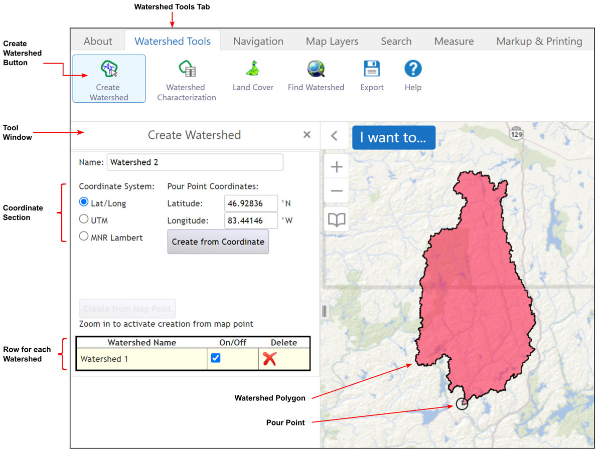
Steps to run the Create Watershed tool
- Click the Watershed Tools tab at the top left of the window.
- Click the Create Watershed button below the Watershed Tools tab.
- Create a pour point by a mouse click on a mapped hydrology feature. To do this, zoom in until the Create from Map Point button becomes enabled (turns from grey to black). The mouse click must be within 90 metres of a mapped stream or lake.
- The generated watershed is added to the bottom row of the tool window and the map display will zoom to the watershed extent.
- Multiple watersheds can be created. Each additional watershed will be added to a new row at the bottom of the tool window and to the map.
- Several options are available for each watershed row.
- Click on a row to select (The row will be highlighted.)
- The watershed can be turned on and off in the map display by clicking the On/Off checkbox.
- The watershed and pour point can be deleted by clicking the Delete icon.
- The watershed and pour point can be downloaded by clicking the Export button.
Click on image for larger version.
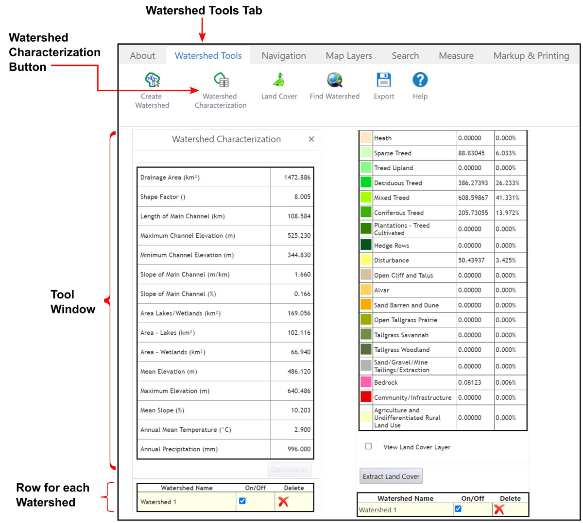
Steps to run the Watershed Characterization tool
- At least one watershed must be generated before using the Watershed Characterization tool.
- Click the Watershed Characterization button located below the Watershed Tools tab to open the tool window.
- Click the desired watershed row to calculate in the bottom section of the tool window. (The selected watershed row will be highlighted.)
- Click the Calculate button to the right of each characterization or click the Calculate All button for all characterizations.
- To extract land cover click the Land Cover button in the Watershed Tools tab and then click the Extract Land Cover button.
Click on image for larger version.
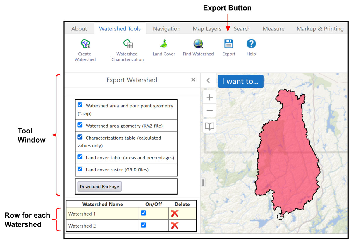
Steps to export data
- Click the Export button located on the right side of the Watershed Tools tab to open the Export Watershed window.
- Click a watershed row, if you have created more than one watershed, to export the data for that watershed.
- Check each checkbox for desired items to include in the export.
- Click the Download Package button.
Click on image for larger version.
Additional information
Use the following options for more information:
- metadata record and user guide
- contact Geospatial Ontario at geospatial@ontario.ca
Email us if you have questions or if you’ve found a problem with the application (include a screen capture showing the issue).