Oxbow Lake Forest Conservation Reserve Management Statement
This document provides policy direction for the protection, development and management of the Oxbow Lake Forest Conservation Reserve and its resources.
Statement of Conservation Interest (C50)
Ministry of Natural Resources
Parry Sound District
Prepared with the assistance of:
Meteek & Company
Huntsville, Ontario
March 2005
Approval statement
We are pleased to approve this Statement of Conservation Interest for Oxbow Lake Forest Conservation Reserve (C50).
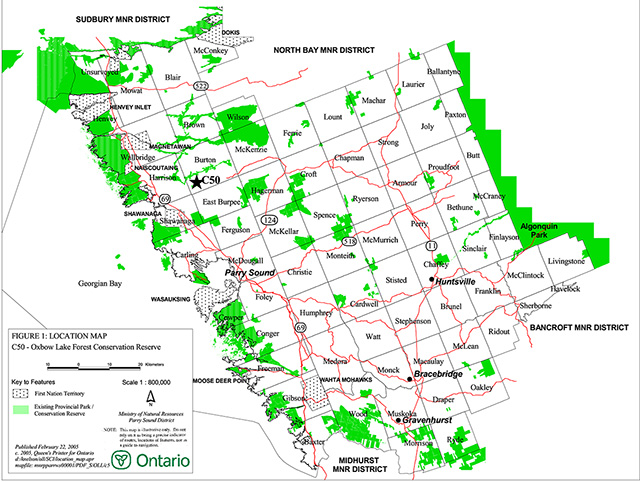
Oxbow Lake Forest Conservation Reserve is located about 35 kilometres north-west of the Town of Parry Sound, in the Territorial District of Parry Sound, about 10 kilometres east of Highway 69. It is located in the south-west corner of Burton Township, immediately to the west of Oxbow Lake (Figure 2), within the Municipality of Whitestone. The conservation reserve consists entirely of Crown land, and it is totally surrounded by Crown land.
This conservation reserve is located within the ecological Site District 5-E7. It provides ecological representation of a rich white birch forest on a low sandy till plain with bare bedrock outcroppings. The site may also provide inland habitat for the nationally and provincially threatened eastern Massasauga rattlesnake.
Oxbow Lake Forest Conservation Reserve is one of 378 new protected areas approved through Ontario’s Living Legacy, a land use strategy aimed, in part, at completing Ontario’s system of parks and protected areas.
During the "Lands for Life" planning process, the public was widely consulted and provided valuable input into what became Ontario’s Living Legacy Land Use Strategy. Comments received during that time, and during consultation related to the formal Public Lands Act regulation of the boundaries of this conservation reserve, were generally supportive of the protection of this area. Stakeholders who provided comment during the earlier consultation for this site were subsequently consulted regarding the draft Statement of Conservation Interest and any comments were considered in the finalization of this document.
This document replaces the Statement of Conservation Interest that was approved in March 2001, to reflect one change in provincial direction (regarding mineral exploration) and to also improve the clarity as to MNR's intent for this site. This Statement of Conservation Interest provides guidance for the management of the conservation reserve and provides the basis for the ongoing monitoring of activities. More detailed direction is not anticipated at this time. Should significant facility development or other uses be considered or complex issues arise which require additional studies, more defined management direction, or special protection measures, then a detailed Resource Management Plan will be prepared with full public consultation.
Oxbow Lake Forest Conservation Reserve is managed under the direction of the District Manager and the Parry Sound Area Supervisor of the Ministry of Natural Resources, Parry Sound District.
Approved by:
R. Griffiths
District Manager
Parry Sound District
Approved by:
Ron Running
Regional Director
Southern Region
Figure 1: Location map - Oxbow Lake Forest Conservation Reserve (C50)
Enlarge figure 1: Location map - Oxbow Lake Forest Conservation Reserve (C50)
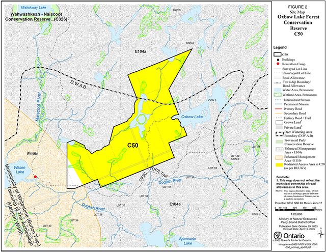
Figure 2: Site map – Oxbow Lake Forest Conservation Reserve (C50)
Enlarge figure 2: Site map – Oxbow Lake Forest Conservation Reserve (C50)
1.0 Introduction
Ontario’s Living Legacy, the result of an extensive planning process that began in early 1997, culminated in the approval in July 1999 of a Land Use Strategy that identifies the intended strategic direction for Crown land in central and northern Ontario, including the completion of Ontario’s system of parks and protected areas. This process, which included public consultation, resulted in the recommendation for regulation of 378 new protected areas, including Oxbow Lake Forest Conservation Reserve (C50).
Oxbow Lake Forest Conservation Reserve is located about 35 kilometres north-west of the Town of Parry Sound, in the Territorial District of Parry Sound, about 10 kilometres east of Highway 69. It is located in the south-west corner of Burton Township, immediately to the west of Oxbow Lake (Figure 1), within the Municipality of Whitestone. The conservation reserve consists entirely of Crown land, and is totally surrounded by Crown land.
Oxbow Lake Forest Conservation Reserve provides representation of a rich white birch forest on a low sandy till plain with bare bedrock outcroppings. Although white birch is the dominant forest type, the site also contains a limited amount of poplar. The conservation reserve provides winter habitat for both moose and deer in addition to inland habitat for a variety of other species including bear, small mammals, birds and the threatened eastern Massasauga rattlesnake. Hunting is the primary recreational activity within this conservation reserve.
Most of this conservation reserve lies within a Restricted Access Area, as identified in the 1983 Parry Sound District Land Use Guidelines. With the approval of the Ontario’s Living Legacy Land Use Strategy in 1999, the Restricted Access Area policies were carried forward into the Land Use Strategy, and continue to apply to all of this conservation reserve, except the extreme south western corner. Adjacent to the conservation reserve, the former Restricted Access Area is now within Parry Sound Interior Enhanced Management Area (E104a). The intent of the Restricted Access Area and E104a is to maintain the remote access characteristics of the vicinity. The Crown lands adjacent to the south-western portion of the conservation reserve are within North Parry Sound Recreation Enhanced Management Area (E119r).
Conservation reserves are established under the authority of the Public Lands Act, Ontario Regulation 805/94. Oxbow Lake Forest Conservation Reserve was established by Ontario Regulation 461/00 on August 10, 2000.
A Statement of Conservation Interest (SCI) is prepared under the direction of Procedural Guideline A – Resource Management Planning (PL. Procedure 3.03.05). The purpose of this Statement of Conservation Interest is to identify and describe the values of Oxbow Lake Forest Conservation Reserve. The Statement of Conservation Interest also outlines the activities that currently occur within the conservation reserve and provides guidelines for the management of current and future activities in the context of protecting the natural, recreational and cultural values, under the authority of Procedural Guideline A – Resource Management Planning (PL Procedure 3.03.05).
1.1 Background information
| Name | Oxbow Lake Forest Conservation Reserve. |
|---|---|
| Ecological site region/site district | Georgian Bay Site Region, Site District 5E-7 |
| OMNR administrative region/district/area | Southern Region/Parry Sound District/Parry Sound Area |
| Total area (hectares) | 383 |
| Regulation date | August 10, 2000, by Ontario Regulation 461/00 |
| First Nations | Robinson-Huron Treaty and Williams Treaty |
| OBM map sheets | 10 17 5550 50500, 5600 50500 |
| UTM coordinates | 17T 56115 505216 (Centroid) |
1.2 Representation/targets
Earth science representation:
Bedrock
- Britt Domain, Algonquin Terrane of the Central Gneiss Belt, in the Proterozoic Grenville Province. (Easton, 1992a)
- Contains leucocratic granitic gneiss, common in the Britt Domain
Surficial
- Shallow glacial sediments
Life science representation:
The following landform types are found in the conservation reserve (Rouse, 2000):
- Ia-23 Weakly broken shallow sandy till plain (bare bedrock, organic)
- Vlla-7 Weakly broken bare bedrock plain (organic)
The predominant vegetation community associated with these landform types is a rich white birch forest.
Cultural resources representation:
No specific cultural studies or inventories have been undertaken within this conservation reserve, and no specific significant cultural resource values have been evaluated or identified to date. Recent regional evaluation (OMNR, 2003) provides generalized broad-brush mapping which shows that this conservation reserve contains areas that have a high potential for cultural heritage sites.
Recreational opportunities:
A recreational inventory report was prepared for this site based on a site visit and existing knowledge and data sources of MNR staff (Benvenuti, 2004). This report and an earlier checklist (Parent & Rouse, 2000) indicate that the area accommodates hunting, and that snowmobiling and all-terrain vehicle use occur, although there are no authorized trails within the conservation reserve. A multipurpose Ontario Federation of Snowmobile Clubs (OFSC) recreational trail travels east-west immediately outside the southern boundary of the conservation reserve, and cuts through the south-western corner of the site.
1.3 Survey work
| Survey level | Earth sciences | Life sciences | Cultural | Recreational | Other |
|---|---|---|---|---|---|
| Reconnaissance | Frey & Duba, 2000 | Rouse, 2000; Noble, 1983 | None | Benvenuti, 2004 Parent & Rouse, 2000; | |
| Detailed | None | None | None | None | |
| Requirement | None | Monitor status of the threatened eastern Massasauga rattlesnake | Research to be encouraged | Monitor use impacts |
2.0 Values to be protected
The conservation reserve is located entirely within Hills (1959) ecological Site District 5E-7. Values include earth science, life science, cultural and recreational/aesthetic values, with an emphasis on the life sciences.
2.1 Earth science
(Earth science information, unless otherwise noted, is taken from Frey & Duba, 2000)
Earth science values are focused on features (bedrock and surficial) that represent the chronology of earth history in the province (Davidson, 1981).
Bedrock:
Oxbow Lake Forest Conservation Reserve is a very small, low relief area of small upland bedrock outcrops. The dominant rock type is granitic gneiss of the Britt Domain, Algonquin Terrane, in the western part of the Central Gneiss Belt of the Proterozoic Grenville Province. The Grenville Province is the product of thrusting and imbrication of the crust to the northwest as it collided with a continental landmass to the southeast.
The Grenville Orogeny, circa 1140 to 1070 million years ago, culminated more than 500 million years of crustal evolution. The eroded roots of the products of these events are displayed in the complexly metamorphosed and deformed rocks of the region (Easton, 1992b, p.1302).
The Algonquin Terrane is one of four lithotectonic terranes of the Central Gneiss Belt. Within the Algonquin Terrane the Britt Domain is one of twelve structural domains. This geological environment is part of the modern organization of the complex products of the mid-Proterozoic Grenville orogenic events (Easton, 1992a & b). As such, its representation in Oxbow Lake Forest Conservation Reserve contributes to the conservation of the Grenville continental accretion theme outlined by Davidson (1981).
From an earth science perspective, the geology of the conservation reserve has local significance in its representation of supracrustal and gneissic rocks, highly deformed in the Parry Sound shear zone at the western margin of the Parry Sound Domain.
Surficial:
Oxbow Lake Forest Conservation Reserve is located in an area of bare bedrock plain, with shallow glacial sediments.
2.2 Life science
(Life science information, unless otherwise noted, is taken from Rouse, 2000)
The conservation reserve is located within Hills' (1959) ecological Site District 5E-7. The assessment of life sciences is primarily focused on landform type and the vegetation communities that occur thereon within the context of an ecological site district. Oxbow Lake Forest Conservation Reserve lies within landform type Ia-23, which is a weakly broken plain surfaced by shallow sandy till, with bare bedrock and pockets of organic materials. It also touches the edge of landform type Vlla-7, a weakly broken bare bedrock plain with scattered organic-filled basins (Noble, 1983)
Representation:
The site is characterized by a rich white birch forest that lies on a low sandy till and bare bedrock plain. Steep slopes occur particularly within the southerly portion of the conservation reserve, with topography ranging from around 235 to 256 metres above sea level. The white birch forest occupies about 75 percent of the conservation reserve; poplar forest occupies about 6 percent; bare rock represents about 10 percent of the area; water about 7 percent; and wetlands (muskeg, brush and alder) about 2 percent.
Condition:
No commercial forest or mining activity has occurred within the conservation reserve within the past 80 years, and no roads exist in the site. Sport hunting occurs in and around the conservation reserve, which is also included in a trapline area (PS-72). An OFSC Trans-Ontario Provincial Snowmobile (TOPS) multipurpose recreational trail extends east-west immediately outside the south boundary of the conservation reserve, and cuts through a small portion of the site’s south-western corner. There is also an unauthorized trail branching north off the TOPS trail that leads into the conservation reserve.
These activities are not considered to have any significant impact on the quality of life science representation.
Diversity:
Detailed inventory has not been conducted. It is expected that floral and faunal diversity is typical of this combination of landform-vegetation complexes.
Ecological considerations:
Aerial moose surveys conducted by Ontario Ministry of Natural Resources (1996, 1999) found moose to be present in the general area around Oxbow Lake Forest Conservation Reserve. The area provides winter habitat for moose.
Special features:
Although the presence of eastern Massassauga rattlesnake (Sistrurus c. catenatus) is unconfirmed, Oxbow Lake Forest Conservation Reserve provides potential inland habitat for this threatened species (COSEWIC – Threatened; OMNR – Threatened).
Significance:
Oxbow Lake Forest Conservation Reserve provides provincially significant representation of a rich white birch forest on an inland bedrock terrain in ecological Site District 5E-7.
2.3 Cultural values:
While no specific cultural studies or inventories have been undertaken within the conservation reserve, and no major cultural resource values have been evaluated or identified to date, recent regional evaluation using generalized broad-brush mapping (OMNR 2003), shows there is an area identified as having high cultural heritage potential along the extreme southern boundary of the site around a tributary of the Dogfish River.
The existing OFSC TOPS trail off Dumont Road follows the path of an old east-west single wire telephone line. This telephone line allowed for communication between two fire towers located in Ardbeg and Pointe au Baril. The line was patrolled in the early 20th century by fire rangers travelling between the towers. Prior to construction of the telephone line, the trail was originally an old cadge road used by wagons and sleighs to service lumber camps in the broader area (Macfie 2004).
2.4 Recreational/aesthetic values:
Oxbow Lake Forest Conservation Reserve lies within an existing Restricted Access Area (OMNR, 1983), that is intended to provide opportunities for recreation in a relatively remote setting. The access restrictions in this site also apply to most of the surrounding lands, which are in the Parry Sound Interior Remote Access Enhanced Management Area, E104a. The purpose of this restricted access is to allow opportunities for recreation in a relatively remote setting; public access for recreation purposes in this area is restricted to the trails and means of access that were in place in 1983, and to boat-in, fly-in or walk-in means. The lands immediately southwest of this site fall within the North Parry Sound Recreation Enhanced Management Area, E119r.
Although no specific studies have been undertaken, the conservation reserve is known to be used for hunting and some recreational activities, specifically, the use of all-terrain vehicles (in association with hunting activity) and snowmobiles. These occur at relatively low numbers, consistent with the "remote" nature of the site and the conditions of the Restricted Access Area.
The lack of significant water bodies within the conservation reserve precludes the potential for recreational fishing, although there may be fishing opportunities in adjacent Oxbow Lake. An unauthorized trail extends from the OFSC TOPS recreational trail, and provides access to Oxbow Lake.
The conservation reserve also has potential for providing opportunities for solitude, general outdoor/exploring activities, and general nature activities.
The current and expected levels of recreational activities within Oxbow Lake Forest Conservation Reserve have local significance.
The distance of this conservation reserve from urban areas has resulted in a relatively pristine night sky, which enhances the sense of remoteness and wilderness of this site. Pristine night skies are considered a significant value, given the increasingly limited areas of southern and central Ontario that are not heavily affected by light pollution.
3.0 Management guidelines
MNR's Class Environmental Assessment for Provincial Parks and Conservation Reserves came into effect on January 10, 2005. All new MNR projects in conservation reserves, and any new approvals or permits issued, must meet the legal requirements of this Class Environmental Assessment, and any relevant amendments.
3.1 Land tenure
Background:
Oxbow Lake Forest Conservation Reserve consists entirely of Crown land, and it is surrounded on all sides by Crown land. Except for a registered trapline (PS-72) which includes this area, there are no land use permits, licenses or easements that apply to land within the conservation reserve.
The conservation reserve is excluded from the surrounding Bear Management Area PS-49-003.
There are no municipal road allowances cutting through this site, since portions of the road allowances between Concessions 2 and 3 and between Lots 35 and 36 were stopped up and closed prior to incorporation of this area into the Municipality of Whitestone, These lands were included within the regulated conservation reserve.
Guideline:
Sale of Crown lands within the conservation reserve will not be considered.
Land tenure will continue for trapping through the registered trapline areas. Neither new trapper’s cabins nor new recreation camps are permitted in conservation reserves.
This site, or portions of it, cannot be incorporated into a Bear Management Area.
3.2 Development
Background:
There are no existing buildings, structures, or constructed facilities within the conservation reserve. There are no existing roads in the conservation reserve, although there are trapline trails used in conjunction with the registered trapline area. An OFSC TOPS recreational trail runs very close to the southerly boundary of the conservation reserve, and crosses through a small portion of the site’s southwest corner. An unauthorized trail extends from this trail providing access to Oxbow Lake.
All of this conservation reserve, except the south-west corner, lies within an extensive pre-existing Restricted Access Area, intended "to maintain an area of the Parry Sound District, which provides both opportunities for recreation in a relatively remote setting and opportunities for resource extraction". (OMNR, 1983) Adjacent to the conservation reserve, the former Restricted Access Area is now within the Parry Sound Interior Enhanced Management Area (E104a). The intent of the Restricted Access Area and E104a is to maintain the remote access characteristics. The south-western corner of the conservation reserve is adjacent to a Recreation Enhanced Management Area (North Parry Sound Enhanced Management Area – E119r). The intent of that land use designation is to provide for semi-remote recreation, access, natural resource protection and extraction.
Guideline:
Consistent with the Restricted Access Area, new roads established for resource management or extraction in the E104a areas surrounding the conservation reserve will be closed to recreational use.
New private access or resource access roads, and additions to or upgrading of existing roads are not permitted within the conservation reserve.
In keeping with the pre-existing Restricted Access Area, no new trails, extensions to existing trails or upgrading of existing trails will be authorized in E104a, or within the Restricted Access Area portions of the conservation reserve.
The use of unauthorized trails that predate this conservation reserve will be monitored. Depending on the results of monitoring, some or all of the unauthorized trails may need to be redirected from sensitive areas or eliminated completely. Otherwise, there is no intent to mark or upgrade these trails.
Unauthorized works within the conservation reserve will be handled in accordance with the Public Lands Act, and any required removal of these works will be at the expense of those responsible.
No mineral exploration is permitted within this conservation reserve. This policy direction is based on a commitment made by the Ministry of Natural Resources and the Ministry of Northern Development and Mines in March 2002. This direction replaces that identified in the 1999 Ontario’s Living Legacy Land Use Strategy (OMNR, 1999), which stated that controlled mineral exploration would be permitted in new conservation reserves which were identified as having provincially significant mineral potential.
Any new development must meet MNR's commitments to protect cultural heritage values (see Section 3.7).
While there is no intent at present to provide or permit any new development in this conservation reserve that would require lighting, should this be considered at some point in the future the MNR will not allow unnecessary, undirected light pollution. This commitment recognizes the wilderness and biological values provided by a pristine night sky.
3.3 Recreation activities
Background:
Existing known recreational activities are limited to sport hunting, some general exploring and snowmobile and all-terrain vehicle use.
Oxbow Lake Forest Conservation Reserve can be accessed from an Ontario Federation of Snowmobile Clubs (OFSC) Trans Ontario Provincial System (TOPS) trail via Dumont Road (formerly Wilson Lake Road) off Highway 69. The trail runs east-west immediately outside the southern boundary of the conservation reserve and cuts into the site in its extreme southwest corner. There is also an unauthorized trail branching north off the TOPS trail that leads into Oxbow Lake. While the conservation reserve does not contain water bodies suitable for angling, adjacent Oxbow Lake may provide some angling opportunities.
There are no Crown land recreation camps situated in the site; however there are a number of camps located outside the boundary of the site within close proximity.
Guideline:
Hunting is permitted to continue within the conservation reserve.
Recreational uses such as hiking, wildlife viewing, snowshoeing, and cross-country skiing, while currently very limited in extent and therefore not managed, are allowed to occur in the conservation reserve.
The use of pre-existing recreational trails (trails that existed at the time of regulation of this conservation reserve), and any increase in use of snowmobiles or all-terrain vehicles will be monitored to ensure that conservation reserve values are not being adversely impacted. Depending on the results of monitoring, those pre-existing trails may need to be redirected from sensitive areas or eliminated completely. There is no intent to mark or upgrade these trails.
New recreational trails for non-motorized use may be considered on a case by case basis only in the extreme southwest portion of the conservation reserve, provided that they meet Procedural Guideline B - Land Uses - Test of Compatibility (see Appendix 1) and the MNR's Environmental Assessment Act requirements. Public consultation will generally be required during the consideration of changes to existing trails, and will always be required for new trails.
New recreational trails for motorized vehicles will generally not be permitted within this conservation reserve, nor realignments of the existing OFSC TOPS trail. An exception to this would apply only to consideration of realignment of the TOPS trail in the extreme south-western corner of the site, outside of the Restricted Access Area. Any realignment must meet the requirements identified in the preceding paragraph.
Off-trail use of snowmobiles and all-terrain vehicles is not permitted, except for the direct retrieval of game.
New recreational activities will be considered on a case by case basis provided they are consistent with maintaining the values of the conservation reserve and comply with Procedural Guideline B – Land Uses – Test of Compatibility (Appendix 1). Emphasis will be placed on activities that have a low impact on the environment of the conservation reserve.
Monitoring of existing and permitted activities will be undertaken as required to ensure that the conservation reserve values are not being adversely impacted.
3.4 Commercial activities
Background:
Current commercial use of the conservation reserve is limited to trapping (PS-72). A Bear Management Area surrounds the conservation reserve, but the conservation reserve is excluded from this Bear Management Area. Forest management activities have not occurred within the conservation reserve area for over 80 years. Likewise, mining activities have not occurred within the conservation reserve.
Guideline:
Trapping will continue to be allowed in the conservation reserve. If the surrounding Commercial Bait Fish Block is assigned in the future, bait fish harvesting operations within the conservation reserve may be considered providing they meet the requirements of Procedural Guideline B – Test of Compatibility.
Conservation reserve regulations do not permit mineral exploration mining, commercial forest harvesting, hydroelectric power development, the extraction of aggregate and peat or other industrial uses (Public Lands Act, Ontario Regulation 805/94). Other new commercial activities must meet the requirements of Procedural Guideline B – Land Uses – Test of Compatibility (Appendix 1).
3.5 Aboriginal interests
Background:
This site is known to be of interest to First Nation communities. There are 2 treaties associated with the area: the Robinson – Huron Treaty of 1850 and the Williams Treaty, (although a Supreme Court decision in 1994 (Howard) validated that the Williams Treaty surrendered hunting, fishing and trapping rights of those First Nations affiliated with that treaty).
Guideline:
The regulation and management of this conservation reserve will not impede the exercise of existing aboriginal or treaty rights. These rights include hunting, fishing, fur harvesting, gathering of plants for a variety of purposes, and the use of ceremonial sites. It is recognized that the manner in which these rights are carried out is not limited to the manner in which they were carried out in the past, but has evolved over time with changes in technology.
The designation of this area as a conservation reserve or the preparation of this Statement of Conservation Interest will not affect any future First Nation land claim settlement. The conservation reserve designation does not preclude consideration of these lands in the settlement of a claim. If deregulation of part or all of a conservation reserve occurs as part of the settlement of a claim, this will be carried out at no cost to First Nations.
3.6 Natural Resource Stewardship
Background:
Vegetation management for specific purposes is not known to have occurred in the past. Wildlife management and fisheries management have been occurring according to the prevailing policies and legislation.
Guideline – general:
The emphasis will be on ensuring that the natural values of the conservation reserve are not negatively affected by current and future activities. Therefore, applications for new specific uses will be carefully studied and reviewed. Necessary studies may be undertaken by proponents, the Ministry, and/or partner organizations.
Guideline – vegetation:
It is recognized that forest fire has been a part of this system in the past. Without future renewal by forest fire, it is anticipated that the rich white birch forest, which predominates in this conservation reserve, will gradually change, and evolve into another vegetation type. However, at this time it is not anticipated that fire will be used as a tool for the management of the site’s vegetative communities. The intent of this site is to allow the existing vegetation communities to evolve naturally.
In accordance with existing conservation reserve policy and the Fire Management Strategy for Ontario, forest fire protection will endeavour to use "light on the land" techniques, which do not unduly disturb the landscape, in this conservation reserve. Examples of light on the land techniques may include limiting the use of heavy equipment, and limiting the number of trees felled during fire response efforts. Input from the local MNR Area Supervisor would be solicited if a forest fire threatens the area. Opportunities for prescribed burning to achieve resource management objectives may be considered. Plans for any prescribed burning will be developed in accordance with the OMNR Prescribed Burn Planning Manual.
Programs may be developed to control forest insects and diseases in the conservation reserve where these threaten significant values in or adjacent to the site. Where insects or disease threaten significant values, in or adjacent to the site, and MNR determines that control is warranted, control within the conservation reserve will be directed by the MNR as narrowly as possible to the specific insect or disease. Biological control will be used wherever possible. In all cases, regard shall be had for Procedural Guideline B – Land Uses – Test of Compatibility (Appendix 1).
Guideline – wildlife:
The management of game and fur species in Oxbow Lake Forest Conservation Reserve will continue consistent with the wildlife management unit (WMU-49), trapline areas (PS-76 and PS 085), and Bear Management Area (PS-49-007) within which it lies.
While the presence of eastern Massasauga rattlesnake (Sistrurus c. catenatus) has not been confirmed in the conservation reserve, the area is recognized as potential habitat for this threatened species. Management activities and proposals for new activities will have regard for the protection of this species and its habitat.
3.7 Cultural Resource Stewardship
Background:
No specific cultural studies or inventories have been undertaken within this conservation reserve, and no specific significant cultural resource values have been evaluated or identified to date. Recent regional evaluation (OMNR 2003) provides generalized broad-brush mapping which shows that this conservation reserve may contain areas that have a high potential for cultural heritage sites.
Guideline:
Should the MNR consider either carrying out or permitting new structural development, significant clearing of vegetation or altering of land within this conservation reserve, the MNR will adhere to the cultural heritage resource screening process as is identified in its Memorandum of Understanding (MOU) with the Ministry of Culture. While the purpose of this MOU is to provide a process to identify and protect cultural heritage resources when the MNR is reviewing work permits or disposing of Crown rights under the authority of the Public Lands Act, the considerations and criteria would also enable the MNR to identify high potential cultural heritage areas for other purposes within conservation reserves. If the screening process indicates that the site of a proposed activity is within an area of high cultural heritage potential, the MNR will consult with the Ministry of Culture to determine the appropriate cultural heritage assessment requirements and will undertake a preliminary archaeological assessment if appropriate.
Interested partners will be encouraged to undertake inventories, studies, and research to document the histories of First Nations, settlement, resource harvest/management and recreation in the area. The MNR will discuss the appropriateness of any proposed archaeological assessment with local First Nations and the Ministry of Culture.
Under the Ontario Heritage Act, a licence is required to carry out any archaeological field work. This includes altering or removing any artefact or any other physical evidence of past human activity.
3.8 Client services
Background:
Access to the conservation reserve has generally been confined to traditional uses for the current commercial and recreational activities. There are no Crown facilities or services developed on or adjacent to the conservation reserve. The information fact sheet for this conservation reserve is currently available to the public through the Parry Sound District Office or via MNR's Internet site, /page/ministry-natural-resources-and-forestry. Information about the values of this conservation reserve is available at the Parry Sound District Office.
Guideline:
The focus will remain on low key information and self-interpretation of conservation reserve values and features. Consideration will be given to the strategic location of identity signs where unauthorized trails, which exit from the OFSC TOPS trail, approach or cross the conservation reserve boundary. Consideration will be given to the preparation of an information brochure (with map) to highlight the features for which this area was identified and appropriate uses to ensure the protection of those features.
3.9 Research
Background:
Research to date has consisted of reconnaissance surveys and checklists of the earth science, life science and recreation values of the conservation reserve. Additional assessment is not planned at present, though may occur if future opportunities are presented.
Guideline:
The Ministry will consider whether there is a need for further inventory and documentation of natural values, and assessment of use/activity impacts on the conservation reserve. All research will be carried out in a non-destructive manner. Research proposals must follow Procedural Guideline C – Research Activities in Conservation Reserves (Appendix 3).
3.10 Marketing
Background:
There has been no direct marketing of Oxbow Lake Forest Conservation Reserve to date. Promotion and information about this site has been primarily through the Ontario’s Living Legacy planning process, and Parry Sound District public consultation regarding the boundaries of the site.
Guideline:
Because the majority of Oxbow Lake Forest Conservation Reserve is located within an extensive Restricted Access Area which is intended to remain relatively inaccessible and to provide for opportunities for recreation in a relatively remote setting, marketing efforts to increase use are not appropriate, and will be kept to a minimum. The future will see continued use of fact sheets to inform the public about the role of the conservation reserve in a provincial system, and about its specific values.
4.0 Implementation
Administrative responsibility for Oxbow Lake Forest Conservation Reserve lies with MNR's Parry Sound Area, Parry Sound District. Implementation of this Statement of Conservation Interest will primarily involve monitoring activities to ensure adherence to the management guidelines. Other activities will include distribution of a fact sheet highlighting the important natural heritage values of the site, and responding to inquiries. Emphasis will be placed on awareness information highlighting reserve values, and monitoring and managing the current approved uses.
Priorities will include:
- Ensure compliance to prescribed management direction of the approved Statement of Conservation Interest
- Ensure compliance with applicable legislation and regulations
- Monitor and evaluate existing and allowed recreational and commercial use levels and impacts as required to ensure that conservation reserve values are not being adversely impacted
- Actively seek partnerships with interested stakeholders
- Encourage further inventory and research of the life science and cultural resources of the conservation reserve; and
- Provide client services (e.g. fact sheet) at nearby MNR offices
5.0 Review and revision of the Statement of Conservation Interest
This Statement of Conservation Interest will be amended through a standard process of minor and major amendments. Minor amendments will be processed in a relatively informal manner and will require the approval of the Area Supervisor; these minor amendments will deal with uses and activities that do not affect any of the policies in this Statement of Conservation Interest (e.g. new uses and/or activities that are consistent with existing permitted uses).
Uses and/or activities that were not anticipated in the approved Statement of Conservation Interest and which may have an impact on the values of the conservation reserve will require a major amendment. This will include an opportunity for public comment and input, and will require the approval of the District Manager and Regional Director.
6.0 References
Benvenuti, J. 2004. Recreation Resource Inventory Report. Oxbow Lake Forest Conservation Reserve. OMNR Parry Sound.
Davidson, R. J. 1981. A framework for the conservation of Ontario’s earth science features. Ontario Ministry of natural Resources, Toronto.
Easton, R. M. 1992a. The Grenville Province and the Proterozoic history of central and southern Ontario; in Geology of Ontario, Ontario Geological Survey, Special Volume 4, Part 2, p715-904.
Easton, R. M. 1992b Tectonic evolution of Ontario. Part 3: Mesoproterozoic evolution of the southeast margin of Laurentia; in Geology of Ontario, Ontario Geological Survey, Special Volume 4, Part 2, p1302-1314.
Frey, E. & Duba D. 2000. Earth Sciences Checksheet, Oxbow Lake Forest Conservation Reserve.
Hills, G. A. 1959. A ready reference to the description of the land of Ontario and its productivity. Ontario Department of Lands and Forests, Division of Research, Maple, Ontario.
Macfie, John. September 2004. Personal communication, Benvenuti-Macfie.
Noble, T. W. 1983. Biophysiographic Analysis of Site Region 5E. Central (Algonquin) Region, Ontario Ministry of Natural Resources.
OMNR. 1993. Parry Sound District Land Use Guidelines.
OMNR. 1999. Ontario’s Living Legacy, Land Use Strategy, July 1999. Ontario Ministry of Natural Resources, Peterborough.
OMNR. 2003. Cultural Heritage Registered Site Reserves and Areas of High Potential, Parry Sound District, Scale 1:150,000.
Parent, C. & Rouse J. D. 2000. Recreation Inventory Checklist. Oxbow Lake Forest Conservation Reserve.
Rouse, J. D. 2000 Life Sciences Checksheet. Oxbow Lake Forest Conservation Reserve.
Appendices
Appendix 1 - Procedural Guideline B – Land Uses – Test of Compatibility (PL Procedure 3.03.05)
The conservation reserve policy provides broad direction with regard to the permitted uses. The policy provides only an indication of the variety of uses that will be considered acceptable in conservation reserves. The only caution is that "any new uses, and commercial activities associated with them, will be considered on a case by case basis, and, they must pass a test of compatibility to be acceptable." What does a 'test of compatibility' mean?
An examination of this must start from the premise of why an area is set aside – specifically, its representative natural heritage values. Criteria are then identified to guide compatibility considerations. These criteria apply to the long-term acceptability of both existing uses and new uses.
-
Conformity to SCI/RMP: SCI describe values for which an area has been set aside and the range of appropriate uses that will be permitted in the area. SCI may also speak to the acceptability of other 'new' uses currently not occurring in the area.
The first 'test' is: "do proposed new land uses and/or commercial activities conform to the direction of the SCI/RMP for the conservation reserve? Would the new use(s) depart from the spirit of appropriate indicator land uses in the SCI/RMP?"
- Impact Assessment: If the proposed use(s) pass test 1 it is important to determine their impact on the area before they are approved. This should include the following:
- Impact on natural heritage values: "will the new use(s) impact any natural values in the area? If so how and to what degree? Is it tolerable?"
- Impact on cultural values: "will the new use(s) impact an historical or archaeological values in the area?"
- Impact on research activities: "will the new use(s) affect research activities in the area?"
- Impact on current uses: "will the new use(s) have any negative impact on the array of current uses?"
- Impact on area administration: "will the new use(s) increase administrative costs and/or complexity?" (For example, the cost of area monitoring, security and enforcement).
- Impact on accommodating the use outside the conservation reserve: "Could the use(s) be accommodated as well or better outside the conservation reserve?"
- Impact on socio-economics of the area: "will the new use(s) affect the community(ies) surrounding the area in a positive or negative way?" (For example, will the new use make an area less remote thereby affecting a local tourism industry that is dependent on the area’s remoteness for its appeal?"
- Impact on area accessibility: "does the new use(s) give someone exclusive rights to the area or a portion of the area to the exclusion of other existing uses?"
The following table (Appendix 2) provides a guide of indicator uses for the consideration of uses that may be permitted within conservation reserves. For any specific conservation reserve that test of compatibility should be applied to determine which specific uses are acceptable.
Appendix 2 - Indicator uses for Conservation Reserves: generic and specific
Recreation
| Activities | Existing generic policy permitted? | New generic policy permitted? | Specific Application in Oxbow Lake Forest Conservation Reserve C50 |
|---|---|---|---|
| Sport fishing | Yes | Yes | Yes |
| Sport hunting | Yes | Yes | Yes |
| Food gathering | Yes | Yes | YesA |
| Facility infrastructure | Maybe | Maybe | Maybe |
| Off-trail snowmobiling | No1 | No1 | No1 |
| Off-trail all-terrain vehicle use | No1 | No1 | No1 |
| Rock climbing/caving | Maybe | Maybe | Maybe |
| Canoeing/kayaking | Yes | Yes | Yes |
| Motorized boating | Yes | Yes | N/A |
| Picnicking | Yes | Yes | Yes |
| Camping | Maybe | Maybe | Yes |
| Trails: Hiking | Yes | Maybe | MaybeB |
| Trails: X-country skiing | Yes | Maybe | MaybeB |
| Trails: Cycling | Yes | Maybe | MaybeB |
| Trails: Horse riding | Yes | Maybe | MaybeB |
| Trails: Snowmobiling | Yes | Maybe | MaybeB |
| Trails: All-terrain vehicles | Yes | Maybe | MaybeB |
Science, education & heritage appreciation
| Activities | Existing generic policy permitted? | New generic policy permitted? | Specific Application in Oxbow Lake Forest Conservation Reserve C50 |
|---|---|---|---|
| Research | Yes | Yes | Yes |
| General walking | Yes | Yes | Yes |
| Photography & Painting | Yes | Yes | Yes |
| Wildlife viewing | Yes | Yes | Yes |
| Outdoor Education/Interpretation | Yes | Yes | Yes |
| Collecting | No | No2 | No2 |
Commercial activities
| Activities | Existing generic policy permitted? | New generic policy permitted? | Specific Application in Oxbow Lake Forest Conservation Reserve C50 |
|---|---|---|---|
| Food harvesting | Maybe | Maybe | No |
| Fishing | Maybe | Maybe | No |
| Bait Fish harvesting | Yes | Maybe | Maybe |
| Fur harvesting | Yes | Maybe | Yes3 |
| Trap cabins | Yes | No | No |
| Resort – outpost camp | Yes | No | No |
| Outfitting – bear management | Yes | No | No |
| Wild rice harvesting | Yes | Maybe | N/A |
Resource management
| Activities | Existing generic policy permitted? | New generic policy permitted? | Specific Application in Oxbow Lake Forest Conservation Reserve C50 |
|---|---|---|---|
| Inventory monitoring | Yes | Yes | Yes |
| Featured species management | Maybe | Maybe | Maybe |
| Natural systems management | Maybe | Maybe | Maybe |
| Insect and disease control | Maybe | Maybe | Maybe |
Industrial activities
| Activities | Existing generic policy permitted? | New generic policy permitted? | Specific Application in Oxbow Lake Forest Conservation Reserve C50 |
|---|---|---|---|
| Timber harvesting | No | No | No |
| Mineral exploration | No | No | No |
| Mining | No | No | No |
| Hydro generation | No | No | No |
| Energy transmission corridors | Yes | No4 | No4 |
| Communications corridors | Yes | No4 | No4 |
| Public transportation corridors | Yes | No4 | No4 |
| Resource access roads | Maybe | No | No |
| Private access roads | Maybe | No5 | No |
Other activities
| Activities | Existing generic policy permitted? | New generic policy permitted? | Specific Application in Oxbow Lake Forest Conservation Reserve C50 |
|---|---|---|---|
| Land Disposition | Maybe6 | Maybe6 | Maybe6 |
| Recreation Camps | YesC | No | No |
Notes:
On generic policy application in conservation reserves:
1For direct retrieval of game only.
2Only as a part of an approved research project.
3Transfer requests will be considered in the context of the Statement of Conservation Interest or Resource Management Plan for each conservation reserve.
4Existing use is permitted to continue. New transportation corridors, communications lines, and transmission lines are discouraged in conservation reserves except under unusual circumstances where there are no other viable alternatives.
5New private roads, including additions to existing roads, will not be permitted except where there are existing commitments.
6Sale of Crown lands in conservation reserves is not permitted, except for certain minor dispositions (e.g. sale of small parcel of land where adjacent private lot is too small to enable installation of a septic system, or to facilitate legal title to lands where there has been a long-standing encroachment of a dwelling on Crown land) where they do not detrimentally affect the values an area is intended to protect.
On specific policy application in Oxbow Lake Forest Conservation Reserve:
AFood gathering is permitted for personal consumption only and must be conducted in a sustainable manner, and such that it does not harm the values of the conservation reserve.
BUnauthorized recreational trails that pre-dated this conservation reserve and pre-date the 1983 Restricted Access Area may permitted to continue in this conservation reserves as long as there are no significant environmental impacts and they do not impair the natural features and values for which the area is identified. In keeping with the pre-existing Restricted Access Area surrounding the majority of the conservation reserve, new trails, extensions to existing trails or up-grading of existing trails will not be authorized, except that a realignment of the existing TOPS trail could be considered in the extreme south-west corner of the conservation reserve.
CWhile existing authorized recreation camps within conservation reserves are generally permitted to continue, new recreation camps are not permitted.
Appendix 3 - Procedural Guideline C - Research Activities in Conservation Reserves (PL Procedure 3.03.05)
Purpose
To encourage contributions to the goal of conservation reserves by:
- Providing direction for research activities associated with conservation reserves; and
- Establishing a process for the review and approval of proposals by researchers which could have an impact on the values protected by the conservation reserve.
Definition
Research means any investigation or study of the natural, cultural, economic, management or other features or characteristics of conservation reserves.
Guidelines
Research will be encouraged to provide a better understanding of the natural values protected by a conservation reserve and to advance their protection, planning and management. The Statement of Conservation Interest will define, for each conservation reserve, the key research issues, set out the parameters within which research may occur and identify research needs.
Applications and approvals
Researchers must apply in writing to the relevant Area Supervisor(s) for permission to conduct research. The request letter must contain a statement explaining why the proposed research should be undertaken in the particular conservation reserve in preference to another location.
Proposals will be reviewed and approved by the relevant Area Supervisor(s), guided by the Statement of Conservation Interest prepared for each reserve (see Guideline A – Resource Management Planning) and using Guideline B – Land Uses – Test of Compatibility. Permission must be granted in writing, including any conditions to be met in conducting the research, prior to the undertaking of any research.
Terms and conditions
Permission to conduct research under this policy will be valid for a period of 12 consecutive months from the date of issue. Permission to continue a research project for an additional period of 12 months or less may be granted upon submission of a written request and a progress report. The Ministry may require the posting of collateral to assure that the terms and conditions of granting permission are met.
The Area Supervisors may suspend or revoke permission at any time for failure on the part of the researcher to meet:
- The intent of this policy
- The requirements under the Public Lands Act, Ontario Regulation 805/94 including all amendments, where applicable
- The requirements under any other Act or regulations of Ontario or Canada, including those governing the taking, handling, storing, confining, fur harvesting, excavating and marketing any specimen, artefact, information or action (for example, scientific collector’s permit)
- The conditions and agreements specified in granting permission
Final report
The researcher will submit copies of reports, publications and theses following the results of the project to the relevant Area Supervisor(s).